
Cora Gold Limited / EPIC: CORA.L / Market: AIM / Sector: Mining
16 November 2021
Cora Gold Limited (‘Cora’ or ‘the Company’)
Updated Mineral Resource Estimate at Sanankoro Gold Project
Cora Gold Limited, the West African focused gold company, is pleased to announce an updated Mineral
Resource Estimate (‘MRE’) prepared by CSA Global (UK) Ltd in accordance with The JORC Code (2012 Edition)
for the Sanankoro Gold Project (‘Sanankoro’ or ‘the Project’) in Southern Mali. The updated MRE follows the
recently completed ~43,000m drilling campaign at Sanankoro which focussed on Mineral Resource growth
and upgrading existing Mineral Resources to higher confidence categories.
HIGHLIGHTS
● +200% increase in total ounces from maiden MRE in December 2019 and significant upgrade to
Indicated category using a 0.4g/t cut off and a US$1,800/oz optimised pit shell
● Pit constrained Mineral Resource Estimate of 21.9 million tonnes (‘t’) at 1.15 grams per tonne (‘g/t’)
gold (‘Au’) for a total of 809.3 thousand ounces (koz) of Au, including:
o 540.6 koz @ 1.33 g/t Au in the Indicated category
o 268.7 koz @ 0.90 g/t Au in the Inferred category
o All deposits remain open in all directions
o Maiden Mineral Resource at Zone C
● The Company’s strategy was to deliver open pit-able, free-digging oxide-focussed ounces for the on-
going Definitive Feasibility Study (‘DFS’) – this MRE supports that potential with:
o 67% of total ounces in the Indicated category
o 77% of the gold is in the oxide zone with a further 22% in the transitional zone
o Previous metallurgical testwork shows +94% recoveries (RNS dated 29 September 2020)
o Base of oxidation ranges from 60m to 207m deep
● MRE based on around 7.5km surface expression of the total 33 linear km strike length of the potential
mineralised zones identified in the 2018 Exploration Target of up to 2 Moz potential within 100 m of
surface at Sanankoro (SRK, 2018)
● There are multiple higher grade ore shoots within the deposits which offer the potential for higher
grade production in early years of mining
● Work on the DFS is gaining momentum following appointment of consultants and completion is
expected in H1 2022
Bert Monro, CEO of Cora, commented, “I am delighted with the updated Mineral Resource Estimate at
Sanankoro which has exceeded our expectations from the start of the drill programme and is a major step in
our development plan, which is focussed on delivering a DFS during H1 2022. Not only has the total Mineral
Resource been expanded by over 200% from our maiden Mineral Resource but there has also been an excellent
conversion from Inferred to Indicated Mineral Resources. Furthermore, nearly all of the MRE mineralisation is
in the oxide and transitional zones and is in line with the Company’s strategy of delivering an open pit, free
digging, high-recovery gold mine at Sanankoro.
“In September 2021 the Company signed a revised term sheet with Lionhead for US$25m Project Finance to
support the development of the Sanankoro Gold Project on completion of the DFS in 2022. This Mineral
Resource update is the first step towards delivering that strategy and the Company is extremely pleased to be
moving towards a construction decision.”
DETAILS
The Company continues to focus on developing Sanankoro towards the construction of an open pit, oxide
focussed, gold mine anticipated H2 2022. The Company drilled ~43,000 m during 2021 to enable this updated
MRE to build on the maiden MRE of December 2019. Having received the final assay results in October (see
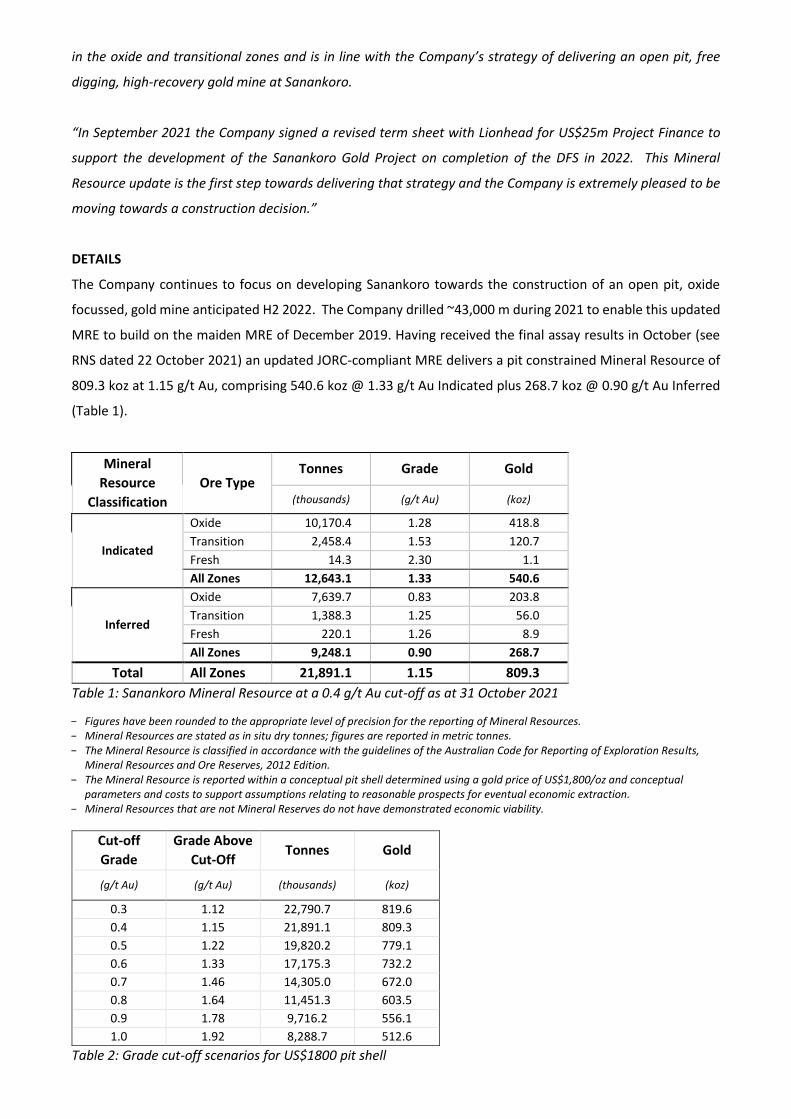
RNS dated 22 October 2021) an updated JORC-compliant MRE delivers a pit constrained Mineral Resource of
809.3 koz at 1.15 g/t Au, comprising 540.6 koz @ 1.33 g/t Au Indicated plus 268.7 koz @ 0.90 g/t Au Inferred
(Table 1).
Mineral
Resource
Classification
Ore Type Tonnes Grade Gold
(thousands) (g/t Au) (koz)
Indicated
Oxide 10,170.4 1.28 418.8
Transition 2,458.4 1.53 120.7
Fresh 14.3 2.30 1.1
All Zones 12,643.1 1.33 540.6
Inferred
Oxide 7,639.7 0.83 203.8
Transition 1,388.3 1.25 56.0
Fresh 220.1 1.26 8.9
All Zones 9,248.1 0.90 268.7
Total All Zones 21,891.1 1.15 809.3
Table 1: Sanankoro Mineral Resource at a 0.4 g/t Au cut-off as at 31 October 2021
− Figures have been rounded to the appropriate level of precision for the reporting of Mineral Resources. − Mineral Resources are stated as in situ dry tonnes; figures are reported in metric tonnes. − The Mineral Resource is classified in accordance with the guidelines of the Australian Code for Reporting of Exploration Results,
Mineral Resources and Ore Reserves, 2012 Edition. − The Mineral Resource is reported within a conceptual pit shell determined using a gold price of US$1,800/oz and conceptual
parameters and costs to support assumptions relating to reasonable prospects for eventual economic extraction. − Mineral Resources that are not Mineral Reserves do not have demonstrated economic viability.
Cut-off
Grade
Grade Above
Cut-Off Tonnes Gold
(g/t Au) (g/t Au) (thousands) (koz)
0.3 1.12 22,790.7 819.6
0.4 1.15 21,891.1 809.3
0.5 1.22 19,820.2 779.1
0.6 1.33 17,175.3 732.2
0.7 1.46 14,305.0 672.0
0.8 1.64 11,451.3 603.5
0.9 1.78 9,716.2 556.1
1.0 1.92 8,288.7 512.6
Table 2: Grade cut-off scenarios for US$1800 pit shell

An increase in cut-off grade shows the potential for higher-grade material.
Area Classification Tonnes Grade Gold
(thousands) (g/t Au) (koz)
Zone A
Indicated 3,478.4 1.33 149.2
Inferred 743.8 0.62 14.8
Total 4,222.2 1.21 164.0
Zone B
Indicated 2,605.1 1.30 108.8
Inferred 3,470.8 0.79 87.9
Total 6,075.9 1.01 196.7
Selin
Indicated 6,559.6 1.34 282.6
Inferred 1,430.8 0.99 45.7
Total 7,990.4 1.28 328.3
Zone B North Inferred 2,428.5 0.93 72.3
Total 2,428.5 0.93 72.3
Zone C Inferred 1,174.2 1.27 48.0
Total 1,174.2 1.27 48.0
All Zones
Indicated 12,643.1 1.33 540.6
Inferred 9,248.1 0.90 268.7
Total 21,891.1 1.15 809.3
Table 3: Sanankoro Mineral Resource by Deposit
Gold mineralisation was interpreted and modelled from a combination of structural and assay data for each
of the Sanankoro areas (Zone A, B, B North, C and Selin) as indicated below (Figure 1). The mineralisation,
hosted predominantly in the oxide zone, dips between 75° and 88° to the east and ranges from a few metres
to 60 m thick.

Figure 1: Drilling campaign (left) and deposit at Sanankoro modelled at a 0.2 g/t Au threshold (right)
The following cross sections show the geometry of the mineralisation, drill hole orientation and the reporting
pit shells at US$1800/oz for each of the mineralised areas at Zone A, Zone B and Selin (Figures 2 to 4).
Gold grade was estimated by ordinary kriging from 2m composites into 5m x 20m x 20m (XYZ) blocks within
mineralised domains. Bulk density was determined using a water displacement technique on wax-coated core
and assigned to the model based on oxidation and geology, such that the duricrust cap has a density of
2.23 t/m3, the mottled zone 1.95 t/m3, oxide material 1.86 t/m3, transitional material 2.58 t/m3 and fresh rock
2.74 t/m3.

Figure 2: Cross-section looking north showing mineralisation at Zone A and US$1800 RPEEE reporting pit shell (15 m
clipping)
Figure 3: Cross-section looking north showing mineralisation at Zone B and US$1800 RPEEE reporting pit shell (15 m
clipping)

Figure 4: Cross-section looking north showing mineralisation at Selin and US$1800 RPEEE reporting pit shell (15 m
clipping)
A Mineral Resource is a concentration or occurrence of solid material of economic interest in or on the Earth’s
crust in such form, grade, and quantity that there are reasonable prospects for eventual economic extraction
(RPEEE). To satisfy the requirement of RPEEE by open pit mining, reporting pit shells were determined based
on conceptual parameters and costs using an US$1800/oz gold price (Figure 5 and Table 4).
Figure 5: Oblique view looking northeast showing the estimated block model at Selin (2.7km strike length) and US$1,800
RPEEE reporting pit shell

Table 4: Mining and cost parameters use to determine reasonable prospects for eventual economic extraction
Parameter Units Value
Production
Production Rate Tonnes per annum (tpa) 1,000,000 or any
Geotechnical (Overall Pit Slope)
Zone A and C Degrees 35
Zone B and Zone B north Degrees 42
Selin Degrees 42
Mining Factors
Dilution Regularised block model (2.5 * 2.5 * 5 m) - no
flat dilution rate 0
Recovery Regularised block model (2.5 * 2.5 * 5 m) - no
flat dilution rate 0
Processing Recovery
Hardcap - all zones % 80.0
Saprolite + Saprock - Zone A and Zone B % 95.7
Saprolite + Saprock - Zone B North and Selin % 92.9
Fresh rock - all zones % 80.0
Operating Costs
Base Mining Cost
Ore USD/t 2.50
Waste - Free dig USD/t 2.00
Waste - Drill & blast USD/t 2.60
Bench advance mining cost USD/t per 20 m bench height 0.04
Processing Cost USD/tore 10.00
GA USD/tore 5.00
Selling Cost - Only royalty % 5
Metal Price
Au USD/oz 1,800
The Mineral Resource was classified into Indicated and Inferred categories as defined by The Australasian Code
for Reporting of Exploration Results, Mineral Resources and Ore Reserves. Mineral Resource classification
considered the quality and quantity of available data, geological continuity, grade continuity and confidence
in the grade estimates. Indicated Mineral Resources were classified from data that were deemed acceptable
for Mineral Resource estimation and reporting, and where data were sufficient to model mineralisation and
estimate grade with a reasonable level of confidence for Indicated Mineral Resources. To classify Indicated
Mineral Resources, data were generally spaced at 35 x 35 m in Zones A and B and at 40 x 40 m at Selin. The

mineralisation at Selin is deemed to be more continuous, hence the wider spacing allowed for Indicated.
Indicated Mineral Resources have slope of regression values ≥0.75, demonstrating an acceptable level of
confidence in the estimate. Indicated Mineral Resources are reported at Zone A, Zone B and Selin. The
mineralisation at Zone B North and Zone C was deemed to be less continuous, and data were wider spaced
relative to Zones A, B and Selin.
Inferred Mineral Resources were classified beyond the 35 x 35 m (Zones A, B, B North and C) and 40 x 40 m
(Selin) data spacing. Mineral Resources were constrained by the US$1800 RPEEE pit, below which
mineralisation was not classified and therefore not reported (Figure 6).
Figure 6: Oblique view looking northeast showing the classified block model at Zones A to C within the US$1,800 RPEEE
reporting pit shell

Background on the Geology
Sanankoro is located on the leading western edge of the Yanfolila-Kalana Volcanic Belt, which is the western-
most expression of the cratonic Baoulé-Mossi domain, on the major transcrustal margin with the Siguiri Basin.
There is major deep-seated structural architecture across the district which links the major gold mines at
Siguiri, Lero, Tri-K, Kalana and Yanfolila.
On a project scale, Sanankoro is characterised by the 2 km wide Sanankoro Shear Zone, which can be traced
over 30 km from Kabaya South in the western Yanfolila Mine to north of the Niger River beyond Selin and onto
Karan. Within the project area, each of the prospects are underpinned by a strong linear parallel, and where
strong mineralisation is developed, a pronounced localised NE-SW focused zone of en-echelon veining and
associated sulphide development.
Selin Geology
Selin is hosted on the eastern margin of the Sanankoro Shear Zone in the north-eastern corner of the
Sanankoro permit. The Selin deposit has a typical interference node control but with the additional positive
impact of a strong, rheological diorite intrusive host. The gold geology at Selin is anchored along this linear,
en-echelon or possibly folded, diorite igneous intrusive which cores the volcaniclastic thrust assemblage and
focuses the gold deposition.
Recent core drilling into Selin has enlightened the genetic model for this deposit by discovering 4-6 multiple
early/pre-D3 dykes of diorite intruding the 65-80° W dipping axial trace of a western hanging-wall F3 anti-form
on this major reactivated D2 east-verging thrust. The >100 m wide Selin Shear Zone may be a regional back-
thrust and the dominant eastern margin of the regional west-verging Sanankoro thrust. The largest diorite unit
is demonstrably discordant and sits immediately west and adjacent to a major early ductile, 10-30 m wide
footwall carbonaceous shear. Progressive deformation has folded, warped and possibly cross-faulted the
diorite units prior to gold deposition. The early footwall shear fabrics are overprinted by later semi-brittle to
brittle graphitic faults which locally convert all protolith to graphitic schist on sub-metre scale. The diorite units
exhibit multi-phase veining interference and sulphide development. The dominant sulphide is pyrite with
occasional arsenopyrite and a scattering of chalcopyrite. Alteration minerals are predominantly sericite, silica,
fuchsite, ankerite, graphite and calcite.
Zone A, Zone B and Zone C Geology
Zone A is the second major deposit at Sanankoro behind Selin and shores up the southern limit of the
11.5 km mineralised corridor, which forms the backbone to the Sanankoro Project. Zone A is the southernmost
expression of the 010o trending central axis of the Sanankoro Shear Zone, which is located 900 m west of the
Selin Boundary Shear and hosts the 5.8 km chain of deposits from Zone A through Zone B to Target 3 (Zone B
North). The deposits of this central trend verge westward mimicking the regional sense of thrusting.

Zone B is the third major deposit at Sanankoro behind Selin and Zone A. It is the strike extension of Zone A,
located 800 m to the north. The Sanankoro Main Trend strikes for 6 km from the south end of Zone A to the
north end of Target 3 (Zone B North). Detailed sectional drilling is required along the length of this major
generative gold system. The local structural facing and stratigraphy of Zone B is very similar to Zone A with the
western footwall sequences hosting more crystalline volcanic tuffaceous units and the eastern, hanging wall
assemblages being more basinal sediments. Zone B hosts an impressive scale of hydrothermal activity and the
broad horizontal widths of mineralisation observed in the recent drilling bodes well for future discovery
potential along the central and southern sections of the Sanankoro Main Shear Zone (SMSZ).
Zone C is located 650 m southwest of Zone A on the parallel, +7 km long Sanankoro West Shear Zone (SWSZ)
which can be traced along a chain of surface workings to the Excavator Prospect, 1.5 km NNW of Target 3
(Zone B North).
Zones A, B and C deposits are identical in style and typical of Siguiri Basin Deposits, fold-thrust controlled
within pelitic and psammitic sediments and very deeply weathered (>120 m from surface). There is a highly
evolved weathering profile with a pronounced 8-10 m thick duricrust-laterite ferro-cap, grading downward
into a well-developed mottled zone until 20-25 m and remains highly weathered until beyond 130 m vertically
within the central mineralised fault zone. Below the saprolite lies a 35-40 m thick transition zone ending in
top of fresh rock at between 160 to 170 m.
All of the host oxide lithologies are weathered to kaolin with only highly corroded quartz vein material
remaining in-situ to mark the main gold faults. Diamond core shows the host lithologies to be predominantly
variably grained basinal pelites and sandstones with minor horizons of small quartz clast, matrix-supported
greywacke inter-bedded within the sequence. A minor intercept of diorite has been identified but does not
form an important control to the mineralisation currently drill tested at Zone A or C. The primary sulphide is
pyrite disseminated around central vein networks and enveloped by a broader hydrothermal halo of silica
flooding, sericite and ankerite.
Permit information
The Sanankoro Gold Project (area 341.87 sq km) is located in the Yanfolila Gold Belt of southern Mali.
Sanankoro comprises five contiguous gold exploration permits, being Bokoro II (area 63.1 sq km; expiry date
25 August 2023), Bokoro Est (area 100 sq km; expiry date 18 September 2028), Dako II (area 44.66 sq km;
expiry date 31 December 2027), Kodiou (area 50 sq km; expiry date 15 May 2023) and Sanankoro II (see below).
This MRE and the ongoing DFS are both focussed on resources within the Sanankoro II gold exploration permit.
In accordance with the 2019 Mining Code of the Republic of Mali, the 84.11 sq km Sanankoro II gold
exploration permit was awarded to Cora Resources Mali SARL on 2 March 2021. Cora Resources Mali SARL is
registered in the Republic of Mali. The duration of the permit is three years, renewable twice at the holder's
request, the duration of each renewal period is extended to three years as such the full term expiry date of
the Sanankoro gold exploration permit is 2 March 2030. Cora Resources Mali SARL is a wholly owned

subsidiary of Sankarani Ressources SARL which in turn is a 95% subsidiary of Cora Gold Limited. Sankarani
Ressources SARL is registered in the Republic of Mali. Cora Gold Limited is registered in the British Virgin
Islands. The residual 5% interest in Sankarani Ressources SARL may be acquired from a third party for the sum
of US$1 million. In addition, the Sanankoro II permit is subject to a third party 1% Net Smelter Return (‘NSR’)
royalty. All fees due to the government in respect of the Sanankoro II gold exploration permit have been paid
and the permit is in good standing.
Competent persons statement:
The Mineral Resource estimate was carried out by Mr. Anton Geldenhuys (MEng), a registered Professional
Natural Scientist (SACNASP, membership number 400313/04) of CSA Global (Pty) Ltd., who is an independent
Competent Person (CP) as defined by The Australasian Code for Reporting of Exploration Results, Mineral
Resources and Ore Reserves. Mr. Geldenhuys is a geoscientist and is qualified as a geologist (Honours) and
engineer (Masters) and has over 20 years of relevant industry experience. Mr. Geldenhuys is member in good
standing of the South African Council for Natural Scientific Professions (SACNASP) and has sufficient
experience relevant to the commodity, style of mineralisation and activity which he is undertaking to qualify
as a CP under The JORC Code. Mr. Geldenhuys has reviewed and approved the scientific and technical
information in this news release.
Market Abuse Regulation (‘MAR’) Disclosure
This announcement contains inside information for the purposes of Article 7 of the Market Abuse Regulation
(EU) 596/2014 as it forms part of UK domestic law by virtue of the European Union (Withdrawal) Act 2018
("MAR"), and is disclosed in accordance with the company's obligations under Article 17 of MAR.
**ENDS**
For further information, please visit http://www.coragold.com or contact:
Bert Monro
Craig Banfield
Cora Gold Limited +44 (0) 20 3239 0010
Christopher Raggett
Charlie Beeson
finnCap Ltd
Nomad & Joint Broker
+44 (0) 20 7220 0500
Andy Thacker
James Pope
Turner Pope Investments
Joint Broker
+44 (0) 20 3657 0050
Susie Geliher
Selina Lovell
St Brides Partners
Financial PR
Notes
Cora Gold is an emerging West African gold developer with three principal de-risked project areas within two
known gold belts in Mali and Senegal covering over +1,100 sq km. Led by a team with a proven track record

in making multi-million-ounce gold discoveries that have been developed into operating mines, its primary
focus is on developing the Sanankoro Gold Project in the Yanfolila Gold Belt, Southern Mali, where Cora hopes
to commence construction of an open pit oxide focussed gold mine in 2022. An updated mineral resource
estimate on the Project was published in November 2021 which increased the Resources by over 200% (from
the 2019 Maiden resource) to 809,300ozs Au. A Definitive Feasibility Study is expected to be completed in
H1 2022.

Glossary of Terms and Abbreviations
Mineral Resource a concentration or occurrence of solid material of economic interest in or on
the Earth’s crust in such form, grade (or quality), and quantity that there are
reasonable prospects for eventual economic extraction. The location,
quantity, grade (or quality), continuity and other geological characteristics of
a Mineral Resource are known, estimated or interpreted from specific
geological evidence and knowledge, including sampling. Mineral Resources
are sub-divided, in order of increasing geological confidence, into Inferred,
Indicated and Measured categories
Inferred Mineral Resource that part of a Mineral Resource for which quantity and grade (or quality) are
estimated on the basis of limited geological evidence and sampling. Geological
evidence is sufficient to imply but not verify geological and grade (or quality)
continuity. It is based on exploration, sampling and testing information
gathered through appropriate techniques from locations such as outcrops,
trenches, pits, workings and drill holes. An Inferred Mineral Resource has a
lower level of confidence than that applying to an Indicated Mineral Resource
and must not be converted to an Ore Reserve. It is reasonably expected that
the majority of Inferred Mineral Resources could be upgraded to Indicated
Mineral Resources with continued exploration.
Indicated Mineral Resource that part of a Mineral Resource for which quantity, grade (or quality),
densities, shape and physical characteristics are estimated with sufficient
confidence to allow the application of Modifying Factors in sufficient detail to
support mine planning and evaluation of the economic viability of the deposit.
Geological evidence is derived from adequately detailed and reliable
exploration, sampling and testing gathered through appropriate techniques
from locations such as outcrops, trenches, pits, workings and drill holes, and
is sufficient to assume geological and grade (or quality) continuity between
points of observation where data and samples are gathered. An Indicated
Mineral Resource has a lower level of confidence than that applying to a
Measured Mineral Resource and may only be converted to a Probable Ore
Reserve.
Strike the course or bearing of the outcrop of an inclined bed, vein, or fault plane on
a level surface; the direction of a horizontal line perpendicular to the direction
of the dip.
JORC Code The Australasian Code for Reporting of Exploration Results, Mineral
Resources and Ore Reserves, 2012 Edition, Prepared by the Joint Ore Reserves
Committee of The Australasian Institute of Mining and Metallurgy, Australian
Institute of Geoscientists and Minerals Council of Australia (“JORC”).
Drillhole technically, a circular hole drilled by forces applied percussively; loosely and
commonly, the name applies to a circular hole drilled in any manner.
Drilling the operation of making deep holes with a drill for prospecting, exploration,
or valuation.
Core a solid, cylindrical sample of rock typically produced by a rotating drill bit, but
sometimes cut by percussive methods.
Ore Reserves is the economically mineable part of a Measured and/or Indicated Mineral
Resource. It includes diluting materials and allowances for losses, which may
occur when the material is mined or extracted and is defined by studies at Pre-
Feasibility or Feasibility level as appropriate that include application of
Modifying Factors. Such studies demonstrate that, at the time of reporting,
extraction could reasonably be justified.
Competent Person A ‘Competent Person’ is a minerals industry professional who is a Member or
Fellow of The Australasian Institute of Mining and Metallurgy, or of the
Australian Institute of Geoscientists, or of a ‘Recognised Professional
Organisation’ (RPO), as included in a list available on the JORC and ASX
websites. These organisations have enforceable disciplinary processes
including the powers to suspend or expel a member. A Competent Person
must have a minimum of five years relevant experience in the style of
mineralisation or type of deposit under consideration and in the activity which
that person is undertaking. If the Competent Person is preparing
documentation on Exploration Results, the relevant experience must be in
exploration. If the Competent Person is estimating, or supervising the
estimation of Mineral Resources, the relevant experience must be in the
estimation, assessment and evaluation of Mineral Resources. If the
Competent Person is estimating, or supervising the estimation of Ore
Reserves, the relevant experience must be in the estimation, assessment,
evaluation and economic extraction of Ore Reserves.
Dip the angle at which a bed, stratum, or vein is inclined from the horizontal,
measured perpendicular to the strike and in the vertical plane.
Grade the relative quantity or the percentage of ore-mineral or metal content in an
orebody.
Wireframe three dimensional solids representing geological/mineralogical domains.

Cut - off grade The lowest grade of mineralised material that qualifies as Mineral Resource.
Deposit An occurrence of economically interesting minerals.
Exploration The act of investigation for the location of undiscovered mineral deposits.
Assay Measure of gold content.
Mineralisation The process by which minerals are introduced into a rock. More generally, a
term applied to accumulations minerals in quantities ranging from weakly
anomalous to economically recoverable.
Sulphide A sulphur bearing mineral.
Block Model A three-dimensional structure into which variables are interpolated and
extrapolated during the Mineral Resource estimation process.
Saprock Partially weathered bedrock, consisting of a combination of partially
weathered minerals and unweathered minerals, with all the fabric and
structural features of the bedrock maintained.
Saprolite Chemically weathered bedrock, which still retains the original lithological
fabric, but is more altered than saprock.
Hardcap An indurated or hardened layer in or on a soil.
Oxide In the context of this release, all weathered rock, including the saprock,
saprolite and hardcap material.
Exploration Target A statement or estimate of the exploration potential of a mineral deposit in a
defined geological setting where the statement or estimate, quoted as a range
of tonnes and a range of grade (or quality), relates to mineralisation for which
there has been insufficient exploration to estimate a Mineral Resource.
Mt Million tonnes

Au Gold
g/t Grams per tonne
oz Troy ounce
Moz Million troy ounces
MRE Mineral Resource Estimate
RC Reverse circulation
AC Air core
RAB Rotary air blast
CP Competent Person, as defined by the JORC Code

JORC Code, 2012 Edition – Table 1 report
Section 1 Sampling Techniques and Data
(Criteria in this section apply to all succeeding sections.)
Criteria JORC Code explanation Commentary
Sampling techniques
• Nature and quality of sampling (eg cut channels, random chips, or specific specialised industry standard measurement tools appropriate to the minerals under investigation, such as down hole gamma sondes, or handheld XRF instruments, etc). These examples should not be taken as limiting the broad meaning of sampling.
• Include reference to measures taken to ensure sample representivity and the appropriate calibration of any measurement tools or systems used.
• Aspects of the determination of mineralisation that are Material to the Public Report.
• In cases where ‘industry standard’ work has been done this would be relatively simple (eg ‘reverse circulation drilling was used to obtain 1 m samples from which 3 kg was pulverised to produce a 30 g charge for fire assay’). In other cases more explanation may be required, such as where there is coarse gold that has inherent sampling problems. Unusual commodities or mineralisation types (eg submarine nodules) may warrant disclosure of detailed information.
• The Mineral Resource estimate (MRE) is based on reverse circulation chip and diamond drill core sampling. The 2021 programme was composed of 39,791 metres of RC and 3,406.6 metres of DD.
• RC was ubiquitously sampled on 1m intervals. Each rod string is 6m in length and is checked and marked with grease every 1m to allow personnel to observe sampling and drill progress. The driller will sound a horn at the end of each 1 m interval, warning the samplers to switch bags at the cyclone.
• All industry standard RC sample quality procedures were applied and each shift a geologist was present to insure sample quality was maintained, holes were not stopped in mineralisation and activity reporting monitored cost control. No detailed logging or sampling was conducted at the rigs.
• All bulk 1m samples were transported immediately upon hole completion to a central bag farm next to the Sanankoro camp. No samples were left in the field. All samples drilled were shipped to the bag farm for splitting and logging under controlled and secured conditions.
• The 1m bulk samples are riffle split down to 5-6kg using a 3 Tier 75:25 riffle splitter and a duplicate pair of 2-3kg samples are then generated using a 2 tier 50:50 riffle splitter. One sample is sent to the lab and the duplicate is stored for any future re-assay or reference.
• All RC holes are photographed on chip tables and chip trayed after

Criteria JORC Code explanation Commentary
sampling and logging.
• All RC holes are geologically logged and panned for visible gold on 1 m intervals concurrently with sampling.
• The logging and panning results dictate whether the logging or senior geologist will instruct compositing in less favourable intersections of a hole. Composites of 4 m are possible in barren intersections.
• Sampling of DD core aims to maintain a standard 1 m interval but can be sampled from 0.5 m to 1.5 m in length, depending upon the interval required to reach the mineralised contact or select the vein width.
• All core is saw cut. Sample interval ends are saw cut pre-sampling to ensure sampling intervals are adhered to.
• All core boxes are metal.
• All core boxes are photographed wet and dry upon receipt at the core shed from the rig.
• The RC samples were sent to an accredited laboratory where they were pulverised to 85% passing 75 micron in a Labtechnics LM2 puck pulveriser and sub-sampled to provide 2 kg for CN Bottle Roll and/or a 50 g aliquot for fire assay. Bottle roll is the preferred assaying method for oxide materials and fire assay for fresh or sulphide-rich material.
• RAB, aircore and aircore hammer were sampled and analysed as per the RC procedure.
• The DD samples are sent to an accredited laboratory where they were jaw-crushed 95% passing 2 mm, then pulverised down to 85% passing 75 micron in an Labtechnics LM2 puck pulveriser and sub-sampled to provide 2 kg for CN Bottle Roll and/or a 50 g aliquot for fire assay. Bottle roll is the preferred assaying method for oxide

Criteria JORC Code explanation Commentary
materials and fire assay for fresh or sulphide-rich materials.
• Vertical auger drilling was conducted to gain a sample of the interface material below transported surface gravels. Auger holes ranged from 0.5-5.0 m and were sent to an accredited laboratory where they were pulverised to 85% passing 75 micron in a Labtechnics LM2 puck pulveriser and sub-sampled to provide 2 kg for CN Bottle Roll and or a 50 g aliquot for fire assay. Bottle roll is the preferred assaying method for oxide materials and fire assay for fresh or sulphide-rich material.
Drilling techniques
• Drill type (eg core, reverse circulation, open-hole hammer, rotary air blast, auger, Bangka, sonic, etc) and details (eg core diameter, triple or standard tube, depth of diamond tails, face-sampling bit or other type, whether core is oriented and if so, by what method, etc).
• Various drilling techniques have been used at Sanankoro – auger, RAB, air core, aircore hammer, RC and diamond core.
• The database was supplied as two parts, an exploration database consisting of auger, RAB, aircore and aircore hammer; and a Mineral Resource database consisting of RC and diamond drilling.
• All core intervals are orientated using a WELLFORCE DV8 iCORE ORI instrument when geologically possible.
• DD core was drilled on an average of 3 m rod pulls but depending upon ground conditions 1.5 m or 6 m rod pulls could have been applied. PQ was used through the soft, friable oxide from surface normally to between 40 and 80 m. The drill string was reduced subsequently to HQ. NQ was not drilled in 2021.
• RC was drilled using a 5 3/8” face-sampling hammer
• All drilling details and dates are recorded on hole logs and are stored in the COLLAR file on DATASHED™.
Drill sample recovery
• Method of recording and assessing core and chip sample recoveries and results assessed.
• Measures taken to maximise sample recovery and ensure representative nature of the samples.
• Whether a relationship exists between sample recovery and
• DD core was drilled on an average of 3 m rod pulls but depending upon ground conditions 1.5 m or 6 m rod pulls could have been applied. PQ was used through the soft, friable oxide from surface normally to between 40 and 80 metres. The drill string was reduced subsequently to HQ. NQ was not drilled in 2021.
• DD core recoveries were estimated on industry standard methods of

Criteria JORC Code explanation Commentary
grade and whether sample bias may have occurred due to preferential loss/gain of fine/coarse material.
direct tape measure on core reconstructed on a triple-length angle-iron cradle, locked where possible and corrected for stick-up errors.
• RC was drilled using a 5 3/8” face-sampling hammer leading a 41/2“ standard rod string. Auxiliary booster-compressor air packs were used on deeper holes, normally > 110m, to ensure dry sample quality and recovery.
• The RC drilling was sampled on a standard 1 m interval and recoveries assessed quantitively by weighing each sampled metre. A total of 40,640 RC sample weights were recorded in 2021. The practice of weighing drill chip samples immediately from recovery at the rig is Cora Gold standard practice for all RAB, air core and RC drilling.
• Sample quality and recovery are monitored at the rig during drilling shift both observationally by the geologist checking the moisture content, possible contamination and relative recovery along the bag line and quantitively by weighing each of the bulk 1 m samples direct from the cyclone before layout.
• Diamond core and RC recoveries are logged and recorded in the database. Overall recoveries are >90% for the diamond core and >70% for the RC; there are no core loss issues or significant sample recovery problems. A geologist is always present at the rig to monitor and record sample quality.
• The Mineral Resource is defined by DD and RC drilling, which have high sample recoveries. No relationship between sample recovery and grade have been identified at the project. The consistency of the mineralised intervals and density of drilling is considered to preclude any issue of sample bias due to material loss or gain.
Logging • Whether core and chip samples have been geologically and geotechnically logged to a level of detail to support appropriate Mineral Resource estimation, mining studies and metallurgical studies.
• All RC holes are logged, panned and sampled on a standard 1 m resolution. Every 1 m drilled is logged and panned before being sampled.
• 4 m compositing may be instructed in barren sections of drilled hole

Criteria JORC Code explanation Commentary
• Whether logging is qualitative or quantitative in nature. Core (or costean, channel, etc) photography.
• The total length and percentage of the relevant intersections logged.
based on the results of the detailed logging.
• All RC holes are photographed on chip tables and chip trayed after sampling and logging.
• All DD core is transported to the core shed located at the main Sanankoro Camp for full RQD, geotechnical logging and density/PLT determinations prior to being released for geological logging and sampling from top to bottom of hole.
• All core boxes are photographed wet and dry upon receipt at the core shed from the rig.
• The level of detail in the logging is deemed appropriate for Mineral Resource estimation and reporting.
Sub-sampling techniques and sample preparation
• If core, whether cut or sawn and whether quarter, half or all core taken.
• If non-core, whether riffled, tube sampled, rotary split, etc and whether sampled wet or dry.
• For all sample types, the nature, quality and appropriateness of the sample preparation technique.
• Quality control procedures adopted for all sub-sampling stages to maximise representivity of samples.
• Measures taken to ensure that the sampling is representative of the in situ material collected, including for instance results for field duplicate/second-half sampling.
• Whether sample sizes are appropriate to the grain size of the material being sampled.
• All RC chip samples were weighed and riffle split to 2-3kg for submission to the lab. All RC holes are sampled in bulk, logged and panned on a standard 1 m interval. Compositing to 4 m may occur in barren geology.
• All DD core is saw cut and half core sampled. DD sample intervals can range from 0.5 m to 1.5 m, depending on geology.
• A standard 5 in 25 sample QAQC was used throughout 2021, composed of 1 standard, 1 blank, 2 duplicates and 1 triplicate. The 2021 assay stream had a routine 20% QAQC component.
• The database manager monitors all sampling and QAQC vetting of the assay stream.
• Field duplicates assist in determining the representivity of sub-samples.
• QC Category ratios
QC Category DH Sample
Count
QC Sample
Count
Ratio of QC Samples to
DH Samples
Field duplicate 31,600 2,928 1:11

Criteria JORC Code explanation Commentary
Triplicate (Second Field
duplicate) 31,600 1,371 1:23
• Sub-samples are deemed appropriate for Mineral Resource estimation and reporting.
Quality of assay data and laboratory tests
• The nature, quality and appropriateness of the assaying and laboratory procedures used and whether the technique is considered partial or total.
• For geophysical tools, spectrometers, handheld XRF instruments, etc, the parameters used in determining the analysis including instrument make and model, reading times, calibrations factors applied and their derivation, etc.
• Nature of quality control procedures adopted (eg standards, blanks, duplicates, external laboratory checks) and whether acceptable levels of accuracy (i.e. lack of bias) and precision have been established.
• Sample preparation involved oven drying, jaw crushing core P70 passing 2 mm, followed by total pulverisation through an LM2 puck pulveriser to a nominal 85% passing 75 microns.
• Historically it has been proven that the nuggety, highly weathered nature of the Sanankoro oxide mineralisation is best head assayed by 2 kg Bottle Roll/AAS with a 50 g Fire Assay/AAS on the BR tail residue. The bulk of the MRE assay database is completed by this method.
• The fresh sulphide mineralisation is assayed by standard total fusion 50 g Fire Assay/AAS. A total of 18,430 fire assays were reported.
• A total of 29,899 Bottle Roll (Leachwell) assays were reported with 7,561 Fire Assay/AAS Tails
• A standard 5 in 25 sample QAQC was used throughout 2021, composed of 1 standard, 1 blank, 2 duplicates and 1 triplicate. The 2021 assay stream had a routine 20% QAQC component.
• Laboratory summary
Laboratories ALS
Burkina Faso
VERITAS
Cote
d’Ivoire
SGS_
Burkina
Faso
SGS
Mali
No. of Batches 164 3 52 5
No. of DH Samples 22836 165 7782 817
No. of QC Samples 6664 45 1095 124
No. of Standard
Samples 7226 83 2839 159
• Standard type ratios

Criteria JORC Code explanation Commentary
Standard Type DH Sample
Count
Standard
Type
Count
Standard
Sample
Count
Ratio of QC
Standard to
DH Samples
BLANK 31600 1 1702 1:19
CRM 31600 22 1495 1:21
• CRM standards were sourced from accredited suppliers Geostats Pty Ltd. and Rocklabs. CRM standards were used ranging from 0.1 ppm to 78.81 ppm
Std Code Exp Value Exp SD No of Samples Supplier
G301-9 10.47 0.44 97 Geostats
G314-5 5.29 0.17 98 Geostats
G314-8 1.03 0.04 12 Geostats
G315-5 0.1 0.01 12 Geostats
G316-1 0.31 0.02 12 Geostats
G318-3 0.72 0.03 12 Geostats
G320-1 78.81 3.96 99 Geostats
G912-2 2.51 0.11 97 Geostats
G917-1 48.37 1.53 98 Geostats
G917-2 24.36 0.73 98 Geostats
HISILK4 3.463 0.09 24 Rocklabs
OXD151 0.43 0.009 174 Rocklabs
OXE150 0.658 0.016 60 Rocklabs
OXF162 0.832 0.027 49 Rocklabs
OXG140 1.019 0.022 116 Rocklabs
OXH149 1.279 0.035 77 Rocklabs
OXJ161 2.501 0.054 63 Rocklabs
OXK160 3.674 0.078 216 Rocklabs
OXP154 15.262 0.27 13 Rocklabs

Criteria JORC Code explanation Commentary
OXQ115 25.22 0.59 18 Rocklabs
SJ111 2.812 0.068 33 Rocklabs
SL76 5.96 0.192 17 Rocklabs
• Following review of the QAQC, the data are deemed appropriate for Mineral Resource estimation and reporting.
Verification of sampling and assaying
• The verification of significant intersections by either independent or alternative company personnel.
• The use of twinned holes.
• Documentation of primary data, data entry procedures, data verification, data storage (physical and electronic) protocols.
• Discuss any adjustment to assay data.
• The CP has visually verified significant intersections in diamond core and RC drilling during the site visit.
• Geology and sampling data were logged into Excel format templates and sent via e-mail to the database manager. Files were imported into Datashed via configured importers and passed through stringent validation. Validation included:
• Logging codes checked against approved code lists
• Interval overlaps and gaps
• Records beyond end-of-hole
• All digital files received were archived on the workstation hosting the database. This was located on site with the database manager. Scheduled daily backups of the database and file archive were made to a NAS solution located at the same site. Nightly scheduled offsite backups were conducted to a verified backup service provider. All offsite backups are encrypted.
• During 2021 MRE drill program, historical Goldfields RC and DD intercepts were twinned, along with previous Cora Gold aircore and RAB intercepts and previous important DD intercepts which correlated with sections of poor DD core recoveries.
• The Goldfields twin holes correlated closely, under-writing the use of the Goldfields Mineral Resource data in the MRE.
• Overall, the drilling, logging, sampling, assaying and QAQC procedures are considered to be consistent with industry standard practice.

Criteria JORC Code explanation Commentary
• No adjustments or calibrations were made to any assay data used in this estimate.
Location of data points
• Accuracy and quality of surveys used to locate drill holes (collar and down-hole surveys), trenches, mine workings and other locations used in Mineral Resource estimation.
• Specification of the grid system used.
• Quality and adequacy of topographic control.
• Grid System: WGS84 UTM zone 29N (EPSG: 32629)
• All surface survey features were surveyed with a LEICA GS18-T RTK DGPS to within a proven accuracy of 30 cm; Cora Gold conducted the DGPS work. All new and historical Mineral Resource drill collars were located and resurveyed by CG-LEICA in 2021.
• A large number of well distributed ground control points and features were used for the TERRABOTICS satellite survey. All points were set-out or picked-up using CG-LEICA.
• TERRABOTICS UK produced a site specific 139 km2 DTM with 0.3 m RL accuracy using tasked MAXAR orthorectified WV3 imagery flown in Nov-Dec 2020. The DTM was provided in February 2021 and utilised throughout the latest drill programme from March to August 2021.
• The TERRABOTICS DTM proved accurate from on-going survey work to be within 30-50 cm RL. DGPS easting and northing showed better resolution.
• The TERRABOTICS DTM is an acceptable topographic model for Sanankoro which defines the surface relief and maps the artisanal pits across the 139km2 area of interest (AOI) accurately. The WV3 imagery maps the full cadastral and natural features across the project area.
• The 2021 drilling utilised a WELLFORCE CHAMP north-seeking gyro throughout and every drilled RC and DD hole has a detailed gyro DTH survey file. Historically, DTH surveys where conducted, used a REFLEX EZ-TRAC.
• The 2021 DD drilling utilised a WELLFORCE DV8 iCORE ORI

Criteria JORC Code explanation Commentary
orientation tool.
Data spacing and distribution
• Data spacing for reporting of Exploration Results.
• Whether the data spacing and distribution is sufficient to establish the degree of geological and grade continuity appropriate for the Mineral Resource and Ore Reserve estimation procedure(s) and classifications applied.
• Whether sample compositing has been applied.
• The nominal drillhole collar spacing is 50 m x 25 m and 50 m x 50 m.
• Due to the orientation of drill traces on section, data between drillholes can be spaced as close as 10 m in places.
• The mineralised domains have demonstrated sufficient continuity in both geology and grade to support the definition of Inferred and Indicated Mineral Resources as per JORC 2012 guidelines.
Orientation of data in relation to geological structure
• Whether the orientation of sampling achieves unbiased sampling of possible structures and the extent to which this is known, considering the deposit type.
• If the relationship between the drilling orientation and the orientation of key mineralised structures is considered to have introduced a sampling bias, this should be assessed and reported if material.
• The bulk of the drilling is orientated 090o or 270o orthogonal to the strike of the mineralised domains. Structural logging based on oriented core indicates that the main mineralisation controls are +/-20o from 000 north and largely perpendicular to drill direction.
• No orientation-based sampling bias has been identified in the dataset.
Sample security
• The measures taken to ensure sample security. • The full chain of custody is managed by Cora Gold. Samples collected daily from the rigs and transported to the central bag farm and sample processing area next to the main Sanankoro camp where the bulk samples are logged, split and prepared for onward transport to the various labs.
• The samples are stored on site and a truck collects available samples weekly and transports them to Cora Gold office in Bamako for registration and verification prior to onward delivery to either SGS Ouagadougou or ALS Ouagadougou.
• The labs sign sample submissions as evidence of receipt.
• Completed assay files and pdf certificates were distributed to the approved recipients by Lab LIMS. Assay files were imported as received to Datashed and then archived on the workstation hosting the database.
• Database management software used is DATASHED version 4.6.4.2

Criteria JORC Code explanation Commentary
with DB version 4.6.5 with MSSQL Server SQL2017 backend.
Audits or reviews
• The results of any audits or reviews of sampling techniques and data.
• Cora Gold’s Head of Exploration visited each of the labs in November and December 2020 before signing contracts. No issues were identified during the visit.
Section 2 Reporting of Exploration Results
(Criteria listed in the preceding section also apply to this section.)
Criteria JORC Code explanation Commentary
Mineral tenement and land tenure status
• Type, reference name/number, location and ownership including agreements or material issues with third parties such as joint ventures, partnerships, overriding royalties, native title interests, historical sites, wilderness or national park and environmental settings.
• The security of the tenure held at the time of reporting along with any known impediments to obtaining a license to operate in the area.
• The Sanankoro Gold Project (area 341.87 sq km) is located in the
Yanfolila Gold Belt of southern Mali. The Sanankoro Gold Project
comprises five contiguous gold exploration permits, being Bokoro II
(area 63.1 sq km; expiry date 25 August 2023), Bokoro Est (area 100
sq km; expiry date 18 September 2028), Dako II (area 44.66 sq km;
expiry date 31 December 2027), Kodiou (area 50 sq km; expiry date
15 May 2023) and Sanankoro II (see below). The Definitive Feasibility
Study is focused on Mineral Resources within the Sanankoro II gold
exploration permit.
• In accordance with the 2019 Mining Code of the Republic of Mali,
the 84.11 sq km Sanankoro II gold exploration permit was awarded
to Cora Resources Mali SARL on 02 March 2021 (Arrêté no. 2021-
0590-MMEE/SG). Cora Resources Mali SARL is registered in the
Republic of Mali. The duration of the permit is 3 years, renewable
twice at the holder's request, the duration of each renewal period is
extended to 3 years - as such the full-term expiry date of the
Sanankoro gold exploration permit is 02 March 2030. Cora
Resources Mali SARL is a wholly owned subsidiary of Sankarani
Ressources SARL which in turn is a 95% subsidiary of Cora Gold
Limited. Sankarani Ressources SARL is registered in the Republic of

Criteria JORC Code explanation Commentary
Mali. Cora Gold Limited is registered in the British Virgin Islands. The
residual 5% interest in Sankarani Ressources SARL may be acquired
from a third party for the sum of US$1 million. In addition, the
Sanankoro II permit is subject to a third party 1% Net Smelter Return
(‘NSR’) royalty. All fees due to the government in respect of the
Sanankoro II gold exploration permit have been paid and the permit
is in good standing.
• A gold exploration permit over the same area as that covered by the Sanankoro II gold exploration permit was previously held by Sankarani Ressources SARL. This permit expired on 01 February 2020, having been initially awarded on 01 February 2013
Exploration done by other parties
• Acknowledgment and appraisal of exploration by other parties. • Exploration activities on the original Sanankora permit by previous
workers have included geological mapping, rock chip sampling,
termite sampling, trench sampling geophysical surveys and surface
drilling - auger, RAB, air core, reverse circulation and diamond core.
• There were two previous companies who conducted work at
Sanankoro i.e. Randgold between 2004 to 2008 and Goldfields
between 2008 until 2012.
• 2004-2008 RANDGOLD conducted successive programs of soils and
termites geochemical sampling on iterative 500 m, 200 m and 100 m
grids. Broad blocks of Gradient Array IP (GAIP) were completed to
assist drill targeting on the broad regional-scale surface anomalies.
They drilled broad spaced 400 m x 100m auger and RAB fences in
search for bedrock targets.
• 2008-2012 GOLDFIELDS conducted infill soils and termite sampling
down to 100 m x 25 m resolution. They conducted large blocks of
regional Gradient Array IP (GAIP) and three main phases of drilling
ranging from 400 m x 100 m RAB with follow-up air core down to
50 m x 25 m RC and RC with diamond core tails, dependent upon

Criteria JORC Code explanation Commentary
results discovered.
• CORA GOLD acquired the Sanankoro Permit in April 2017 and started
exploration termite sampling in May 2017. Chris Barrett SRK UK -
Principal Exploration Geologist visited Sanankoro March 27th to 30th,
2017 to bless the deal. SRK UK, however, never returned to site to
do any CP due diligence for the 2019 MRE, due to security concerns.
Geology • Deposit type, geological setting and style of mineralisation. • Sanankoro is located on the leading western edge of the Yanfolila-
Kalana Volcanic Belt, which is the western-most expression of the
cratonic Baoulé-Mossi domain, on the major transcrustal margin
with the Siguiri Basin. There is major deep-seated architecture
across the district which links the major gold mines at Siguiri, Lero,
Tri-K, Kalana and Yanfolila.
• On a project scale, Sanankoro is characterised by the 2 km wide
Sanankoro Shear Zone, which can be traced over 30 km from Kabaya
South in the western Yanfolila Mine to north of the Niger River
beyond Selin and onto Karan. Within the project area, each of the
prospects are underpinned by a strong linear parallel, and where
strong mineralisation is developed, a pronounced localised NE-SW
focused zone of en-echelon veining and associated sulphide
development.
• There are five main areas which currently define the Sanankoro Gold
project, which in order of significance are Selin, Zone A, Zone B,
Zone B North and Zone C.
• Selin is hosted on the eastern margin of the Sanankoro Shear Zone in
the north-eastern corner of the Sanankoro permit. The Selin deposit
has a typical interference node control but with the additional
positive impact of a strong, rheological diorite intrusive host. The
gold geology at Selin is anchored along this linear, en-echelon or
possibly folded, diorite igneous intrusive which cores the

Criteria JORC Code explanation Commentary
volcaniclastic thrust assemblage and focuses the gold deposition.
Recent core drilling into Selin has enlightened the genetic model for
this resource deposit by discovering 4-6 multiple early/pre-D3 dykes
of diorite intruding the 65-80°W dipping axial trace of a western
hanging-wall F3 anti-form on this major reactivated D2 east-verging
thrust. The >100 m wide Selin Shear Zone may be a regional back-
thrust and the dominant eastern margin of the regional west-verging
Sanankoro Thrust. The largest diorite unit is demonstrably
discordant and sits immediately west and adjacent to a major early
ductile, 10-30 m wide footwall carbonaceous shear. Progressive
deformation has folded, warped and possibly cross-faulted the
diorite units prior to gold deposition. The early footwall shear fabrics
are overprinted by later semi-brittle to brittle graphitic faults which
locally convert all protolith to graphitic schist on sub-metre scale.
The diorite units exhibit multi-phase veining interference and
sulphide development. The dominant sulphide is pyrite with
occasional arsenopyrite and a scattering of chalcopyrite. Alteration
minerals are predominantly sericite, silica, fuchsite, ankerite,
graphite and calcite.
• Zone A shores up the southern limit of the 11.5 km mineralised
corridor, which forms the backbone to the Sanankoro Project. Zone
A is the southern-most expression of the 010° trending central axis
of the Sanankoro Shear Zone, which sits 900 m west of the Selin
Boundary Shear and hosts the 5.8 km chain of open pit resources
from Zone A through Zone B1, B2, B3 to Target 3. The deposits of
this central trend verge westward mimicking the regional sense of
thrusting.
• Zone B is the strike extension of Zone A, located 800 m to the north.
The Sanankoro Main Trend runs for 6 km from south end of Zone A
to the north end of Target 3. Detailed sectional drilling is required

Criteria JORC Code explanation Commentary
along the length of this major generative gold system. The local
structural facing and stratigraphy of Zone B is very similar to Zone A
with the western footwall sequences hosting more crystalline
volcanic tuffaceous units and the eastern, hanging wall assemblages
being more basinal sediments. Zone B hosts an impressive scale of
hydrothermal activity and the broad horizontal widths of
mineralisation observed in the recent drilling bodes well for future
discovery potential along the central and southern sections of the
Sanankoro Main Shear Zone (SMSZ).
• Zone C is located 650 m southwest of Zone A on the parallel, >7 km
long Sanankoro West Shear Zone (SWSZ) which can be traced along
a chain of surface workings to the Excavator Prospect, 1.5 km NNW
of Target 3. The SWSZ is high in the priority list for drilling in the
2022 programme and a number of SWSZ targets, beyond Zone C, will
be tested for surface potential.
• Zones A, B and C deposits are identical in style and typical of Siguiri
Basin Deposits, fold-thrust controlled within pelitic and psammitic
sediments and very deeply weathered (>120 m from surface). There
is a highly evolved weathering profile with a pronounced 8-10 m
thick duricrust-laterite ferro-cap, grading downward into a well-
developed mottled zone to 20-25 m depth and remains highly
weathered until beyond 140 m vertically within the central
mineralised fault zone. Zone B1 has extremely deep weathering
with shallow oxide densities measured to depths of 190 m down-dip
within the ore zone trough.
• All of the host oxide lithologies are weathered to kaolin with only
highly corroded quartz vein material remaining in-situ to mark the
main gold faults. Diamond core shows the host lithologies to be
predominantly variably grained basinal pelites and sandstones with
minor horizons of small quartz clast, matrix-supported greywacke

Criteria JORC Code explanation Commentary
inter-bedded within the sequence. A minor intercept of diorite has
been identified but does not form an important control to the
mineralisation currently drill tested at Zone A or C. The primary
sulphide is pyrite disseminated around central vein networks and
enveloped by a broader hydrothermal halo of silica flooding, sericite
and ankerite.
Drill hole Information
• A summary of all information material to the understanding of the exploration results including a tabulation of the following information for all Material drill holes:
o easting and northing of the drill hole collar
o elevation or RL (Reduced Level – elevation above sea level in metres) of the drill hole collar
o dip and azimuth of the hole
o down hole length and interception depth
o hole length.
• If the exclusion of this information is justified on the basis that the information is not Material and this exclusion does not detract from the understanding of the report, the Competent Person should clearly explain why this is the case.
• Significant intercepts that form the basis of the MRE have been
released to the AIM in previous announcements (available on the
Cora Gold website) with appropriate tables incorporating Hole ID,
Easting, Northing, From, Depth and Intercept Assay Data.
Appropriate maps and plans accompany this MRE.
• Previous drilling completed by Cora Gold, Goldfields and Randgold is
documented herein and in the publicly available reports "A Mineral
Resource Estimate on the Sanankoro Gold Project, Mali" and “A
Report for the Mining Scoping Study on the Sanankoro Gold Project,
Mali” both prepared by SRK Consultants UK and dated December
2019.
• A complete listing of all drillhole details is not necessary for this
report which describes the Sanankoro Gold Project Resources and in
the Competent Person's opinion the exclusion of this data does not
detract from the understanding of this report.
• The 2021 programme twinned important historical Goldfields and
early Cora Gold, smaller diameter, air core and RC intercepts.
Historical Energold DD NQ core holes exhibited sections of
unacceptably poor recoveries, especially in the deeply oxidised
deposits of Zone A and Zone B1, which were twinned using the deep
RC rig.

Criteria JORC Code explanation Commentary
Data aggregation methods
• In reporting Exploration Results, weighting averaging techniques, maximum and/or minimum grade truncations (eg cutting of high grades) and cut-off grades are usually Material and should be stated.
• Where aggregate intercepts incorporate short lengths of high grade results and longer lengths of low grade results, the procedure used for such aggregation should be stated and some typical examples of such aggregations should be shown in detail.
• The assumptions used for any reporting of metal equivalent values should be clearly stated.
• All RC intersections are sampled and assayed on 1 m intervals but could be composited up to 4 m in areas interpreted to be barren.
• DD core sampling can be 0.5-1.5 m in length depending on geological contacts.
• Significant intercepts have previously been reported using a cut-off grade of 0.5 g/t, without top cuts.
• Mineralised intervals are reported with a maximum of 3 m of consecutive internal dilution of less than 0.5g/t Au. Mineralised intervals are reported on a length-weighted average basis.
• No metal equivalents are reported.
Relationship between mineralisation widths and intercept lengths
• These relationships are particularly important in the reporting of Exploration Results.
• If the geometry of the mineralisation with respect to the drill hole angle is known, its nature should be reported.
• If it is not known and only the down hole lengths are reported, there should be a clear statement to this effect (eg ‘down hole length, true width not known’).
• The orientation of the mineralised zone has been established and the majority of the drilling was planned to intersect the mineralised structures orthogonally or as close as practicable.
• Existing artisanal workings, buildings, sacred sites and drainage sometimes created obstacles which prevented perfect intersection and some holes were required to be drilled at less-than-ideal orientations.
• For the bulk of drillholes, site preparations were carried out and 50 m x 25 m drill spacing applied and acceptable intersection orientations were achieved.
Diagrams • Appropriate maps and sections (with scales) and tabulations of intercepts should be included for any significant discovery being reported These should include, but not be limited to a plan view of drill hole collar locations and appropriate sectional views.
• The appropriate plans and sections are included in this document.
Balanced reporting
• Where comprehensive reporting of all Exploration Results is not practicable, representative reporting of both low and high grades and/or widths should be practiced to avoid misleading reporting of Exploration Results.
• All grades, high and low, are reported accurately with “from” and “to” depths and “hole identification” shown.
Criteria JORC Code explanation Commentary
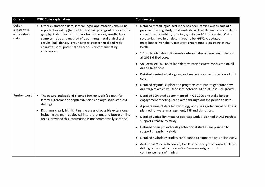
Other substantive exploration data
• Other exploration data, if meaningful and material, should be reported including (but not limited to): geological observations; geophysical survey results; geochemical survey results; bulk samples – size and method of treatment; metallurgical test results; bulk density, groundwater, geotechnical and rock characteristics; potential deleterious or contaminating substances.
• Detailed metallurgical test work has been carried out as part of a previous scoping study. Test work shows that the ore is amenable to conventional crushing, grinding, gravity and CIL processing. Oxide recoveries have been determined to be >95%. A updated metallurgical variability test work programme is on-going at ALS Perth.
• 1.068 detailed dry bulk density determinations were conducted on all 2021 drilled core.
• 589 detailed UCS point load determinations were conducted on all drilled fresh core.
• Detailed geotechnical logging and analysis was conducted on all drill core.
• Detailed regional exploration programs continue to generate new drill targets which will feed into potential Mineral Resource growth.
Further work • The nature and scale of planned further work (eg tests for lateral extensions or depth extensions or large-scale step-out drilling).
• Diagrams clearly highlighting the areas of possible extensions, including the main geological interpretations and future drilling areas, provided this information is not commercially sensitive.
• Detailed ESIA studies commenced in Q2 2020 and stake holder engagement meetings conducted through out the period to date.
• A programme of detailed hydrology and civils geotechnical drilling is planned for water management, TSF and plant sites.
• Detailed variability metallurgical test work is planned at ALS Perth to support a feasibility study.
• Detailed open pit and civils geotechnical studies are planned to support a feasibility study.
• Detailed hydrology studies are planned to support a feasibility study.
• Additional Mineral Resource, Ore Reserve and grade control pattern drilling is planned to update Ore Reserve designs prior to commencement of mining.

Section 3 Estimation and Reporting of Mineral Resources
(Criteria listed in section 1, and where relevant in section 2, also apply to this section.)
Criteria JORC Code explanation Commentary
Database integrity
• Measures taken to ensure that data has not been corrupted by, for example, transcription or keying errors, between its initial collection and its use for Mineral Resource estimation purposes.
• Data validation procedures used.
• Cora Gold (CG) have a dedicated, 30 year experienced Data Manager consultant Mr. Tim Kelemen who devised and built the central Datashed™ database with standardised data collection templates, lookup tables and validation routines for all exploration logging, spatial and sampling data.
• Data collection is updated nightly by the Senior Project Geologist and e-mailed as a quicklog to Tim in Brisbane for upload, validation and reporting. The quicklog Excel file contains DRILL ACTUAL VS PLAN, COLLAR, DTH SURVEY, SAMPLING, GEOLOGY, VG LOGGING, WATER TABLE, INTERCEPTS and LAB SUBMISSION sheets.
• Sample numbers are unique and pre-numbered bags are used.
• CG project geologists validate assays returned back to the drill logged geology in chips and core, previous section intercepts and on-going 3D interpretation within MICROMINE™.
• The MRE data was further validated on import into MICROMINE™ mining software.
• CG employed routine 20% QAQC throughout all of the 2021 assaying stream, involving 1 standard, 1 blank, 2 duplicates and 1 triplicate which were inserted for every 25 samples submitted (5:25)
• Detailed re-splits of important positive and negative intercepts were taken as directed by the Head of Exploration, re-assayed at various labs and cross-checked against original assays as selective QAQC.
• A full record of access and database keystrokes is maintained within Datashed.
• Tim Kelemen is the sole person with access to the Master

Criteria JORC Code explanation Commentary
DATASHED™ database, which consequently is held remotely in Brisbane and backed-up to the cloud nightly.
Site visits • Comment on any site visits undertaken by the Competent Person and the outcome of those visits.
• If no site visits have been undertaken indicate why this is the case.
• The Competent Person (CP) for the MRE, Mr. Anton Geldenhuys, visited the Sanankoro Project in October 2021. The visit included inspection of geology offices, RC Chip Library, DD Core Shed and Library, geotech rock lab and viewing sample/pulp stores, central bag farm, sampling sheds, drill sites, artisanal workings and local surface geology.
• DD coring was on-going at Zone A and Zone B at the time of visit and the CP observed geological/geotechnical logging and density determinations. A number of RC chip trays and diamond core holes were reviewed which form part of this MRE.
Geological interpretation
• Confidence in (or conversely, the uncertainty of) the geological interpretation of the mineral deposit.
• Nature of the data used and of any assumptions made.
• The effect, if any, of alternative interpretations on Mineral Resource estimation.
• The use of geology in guiding and controlling Mineral Resource estimation.
• The factors affecting continuity both of grade and geology.
• The diorite intrusive at Selin plays a significant role in controlling the distribution and tenor of the mineralisation and consequently has been modelled as solid units within the enveloping gold mineralisation wireframe. The diorite intrusion precedes the gold mineralisation event and dips 70-85o to the west
• The main host protolith at Zone A, Zone B, Zone C, Target 3 and surrounding the diorite at Selin are predominantly pelitic sediments and graphitic shears which similarly dip at moderate to high angles to the east
• Overprinting the strong linear N-S lithological architecture is a flat weathering stratigraphy which is characterised from surface with an iron indurated cap of laterite +/- duricrust down to 12-17 m, with an underlying mottled zone of soft plastic clay and highly kaolinized laterite for a further 6-12 m. Below the mottled zone is the saprolite, a highly weathered discernible rock which is present, but down to highly variable depths, across the deposits, reaching depths of >170 m at Zone B. The saprolite can be observed to freshen into transition material relatively rapidly but extends to depths normally between 170 m and 200 m at Zone A and Zone B, in the highlands, before

Criteria JORC Code explanation Commentary
becoming true fresh rock.
• At Selin, the weathering profile is suppressed, probably by the massive siliceous nature of the diorite, with the transition material occurring from 60 m in certain highly siliceous, veined mineralisation locations. The transition diorite mineralisation tends to maintain good CN recoveries.
• Zone A and Zone B exhibit a very pronounced deep trough weathering profile whereas Zone C, Target 3 and Selin seem to host less pronounced weathering probably because of host rock types and topographically low relief positions.
• Mineralisation was modelled using a 0.2 g/t Au threshold value for all areas. The threshold is deemed to be an indicator of mineralised material.
• Higher grade zones were investigated, but these proved to not be sufficiently continuous for modelling and estimation purposes.
• The mineralisation model was guided by local dip and strike trends.
Dimensions • The extent and variability of the Mineral Resource expressed as length (along strike or otherwise), plan width, and depth below surface to the upper and lower limits of the Mineral Resource.
• The Selin mineralisation model is 2.8 km in length along strike, a maximum of 270 m in depth, and is anything from a few to 50 m wide. Selin has a maximum base of oxidation of 80m and is reported to a maximum depth of 180 m below surface.
• The Zone A mineralisation model is 1.2 km in length along strike, a maximum of 245 m in depth, and is anything from a few to 50 m wide Zone A has a maximum base of oxidation of 140m and is reported to a maximum depth of 140 m below surface.
• The Zone B mineralisation model is 1.7 km in length along strike, a maximum of 215 m in depth, and is anything from a few to 50 m wide. Zone B has a maximum base of oxidation of 207m and is reported to a maximum depth of 150 m below surface.
• The Zone C mineralisation model is 750 m in length along strike, a maximum of 160 m in depth, and is anything from a few to 50 m
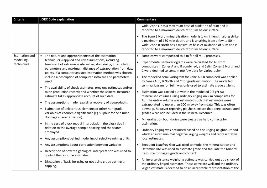
Criteria JORC Code explanation Commentary
wide. Zone C has a maximum base of oxidation of 60m and is reported to a maximum depth of 110 m below surface.
• The Zone B North mineralisation model is 1 km in length along strike, a maximum of 130 m in depth, and is anything from a few to 50 m wide. Zone B North has a maximum base of oxidation of 80m and is reported to a maximum depth of 120 m below surface.
Estimation and modelling techniques
• The nature and appropriateness of the estimation technique(s) applied and key assumptions, including treatment of extreme grade values, domaining, interpolation parameters and maximum distance of extrapolation from data points. If a computer assisted estimation method was chosen include a description of computer software and parameters used.
• The availability of check estimates, previous estimates and/or mine production records and whether the Mineral Resource estimate takes appropriate account of such data.
• The assumptions made regarding recovery of by-products.
• Estimation of deleterious elements or other non-grade variables of economic significance (eg sulphur for acid mine drainage characterisation).
• In the case of block model interpolation, the block size in relation to the average sample spacing and the search employed.
• Any assumptions behind modelling of selective mining units.
• Any assumptions about correlation between variables.
• Description of how the geological interpretation was used to control the resource estimates.
• Discussion of basis for using or not using grade cutting or capping.
• Samples were composited to 2 m for all MRE processes.
• Experimental semi-variograms were calculated for Au from composites in Zones A and B combined, and Selin. Zones B North and C were deemed to contain too few data for variography.
• The modelled semi-variogram for Zone A + B combined was applied to Zones A, B, B North and C for grade estimation. The modelled semi-variogram for Selin was only used to estimate grade at Selin.
• Estimation was carried out within the modelled 0.2 g/t Au mineralised volumes using ordinary kriging on 2 m composites for Au. The entire volume was estimated such that estimates were extrapolated no more than 100 m away from data. This was often downdip, however reporting pit shells ensure that deep extrapolated grades were not included in the Mineral Resource.
• Mineralisation boundaries were treated as hard contacts for estimation.
• Ordinary kriging was optimised based on the kriging neighbourhood which ensured minimal negative kriging weights and representative local estimates.
• Seequent Leapfrog Geo was used to model the mineralisation and Datamine RM was used to estimate grade and tabulate the Mineral Resource tonnages, grade and content.
• An Inverse distance weighting estimate was carried out as a check of the ordinary kriged estimates. These correlate well and the ordinary kriged estimate is deemed to be an acceptable representation of the

Criteria JORC Code explanation Commentary
• The process of validation, the checking process used, the comparison of model data to drill hole data, and use of reconciliation data if available.
insitu Au grade.
• No by-products or deleterious elements were considered in the MRE.
• The parent cell size is 5x20x20 m (XYZ). Collars were drilled at 50x50 m or 50x25 m spacing. The block is deemed to be appropriate relative to the data configuration.
• Search distance was roughly aligned to the variogram range (44 m) for all zones.
• SMUs were not considered in the estimation.
• Composite Au grades were capped for estimation according to area, based on statistics and outliers. Selin composites were capped to 34 g/t Au, Zone A composites were capped to 20 g/t Au, Zone B composites were capped to 21 g/t Au, Zone B North composites were capped to 8.5 g/t Au and Zone C composites were capped to 6 g/t Au.
• Au grade estimates were validated by means of global statistics, swath plots and visual sectional checks of grade in the model vs grade of the composites.
Moisture • Whether the tonnages are estimated on a dry basis or with natural moisture, and the method of determination of the moisture content.
• The tonnages in the estimate are for dry tonnage with no factoring for moisture.
Cut-off parameters
• The basis of the adopted cut-off grade(s) or quality parameters applied.
• The Mineral Resource is reported at a cut-off grade of 0.4 g/t Au, which is what was previously used to report the 2019 Mineral Resource.
• The cut-off grade is in line with other similar reported styles of gold mineralisation.
Mining factors or assumptions
• Assumptions made regarding possible mining methods, minimum mining dimensions and internal (or, if applicable, external) mining dilution. It is always necessary as part of the
• The Mineral Resource is deemed to be amenable to open pit extraction.
• Reasonable prospects for eventual economic extraction was

Criteria JORC Code explanation Commentary
process of determining reasonable prospects for eventual economic extraction to consider potential mining methods, but the assumptions made regarding mining methods and parameters when estimating Mineral Resources may not always be rigorous. Where this is the case, this should be reported with an explanation of the basis of the mining assumptions made.
determined using conceptual mining parameters and a long-term gold price of US$1800/oz.
• The parameters and long-term gold price were used in Whittle to determine a LOM pit shell for reporting the Mineral Resource.
Metallurgical factors or assumptions
• The basis for assumptions or predictions regarding metallurgical amenability. It is always necessary as part of the process of determining reasonable prospects for eventual economic extraction to consider potential metallurgical methods, but the assumptions regarding metallurgical treatment processes and parameters made when reporting Mineral Resources may not always be rigorous. Where this is the case, this should be reported with an explanation of the basis of the metallurgical assumptions made.
• Metallurgical test work conducted upon Selin, Zones A & B gold ore composites - ALS Perth Report No. A21106, March 2021
• Results indicated +95% recoveries from grinding P80 passing 75-micron, gravity and direct CIL.
• As significant programme of metallurgical variability test work is on-going at ALS Perth and will be incorporated into the forthcoming DFS study.
Environmental factors or assumptions
• Assumptions made regarding possible waste and process residue disposal options. It is always necessary as part of the process of determining reasonable prospects for eventual economic extraction to consider the potential environmental impacts of the mining and processing operation. While at this stage the determination of potential environmental impacts, particularly for a greenfields project, may not always be well advanced, the status of early consideration of these potential environmental impacts should be reported. Where these aspects have not been considered this should be reported with an explanation of the environmental assumptions made.
• Metallurgical Test work conducted upon Selin, Zones A & B Gold Ore
Composites - ALS Perth Report No. A21106, March 2021
• The Acid Mine Drainage prediction analysis for all four composite
samples indicated that none would be net acid-producers.
• As significant programme of AMS test work is on-going at ALS Perth
and will be incorporated into the forthcoming DFS study.
• A full DFS-level ESIA study commenced in June 2020 by Digby Wells
and will be incorporated into the forthcoming DFS study.
Bulk density • Whether assumed or determined. If assumed, the basis for the assumptions. If determined, the method used, whether wet or dry, the frequency of the measurements, the nature, size and representativeness of the samples.
• The bulk density for bulk material must have been measured
• Dry bulk density determinations were made using the water displacement method 6 as outlined in AusIMM Monograph 30 – Measurement of Bulk Density for Resource Estimation (Lipton & Horton)
• Dried for 24 hours at 110oC, waxed and weighed using LTB 6002e 0.1

Criteria JORC Code explanation Commentary
by methods that adequately account for void spaces (vugs, porosity, etc), moisture and differences between rock and alteration zones within the deposit.
• Discuss assumptions for bulk density estimates used in the evaluation process of the different materials.
g electronic balance.
• A total of 1,068 dry bulk density determinations were made on full PQ and HQ core samples.
• Bulk density was analysed according to weathering domain by removing outlier values and determining mean values from representative data.
• Mean values were applied to the weathering domains as follows: duricrust cap 2.23 t/m3; mottled zone 1.95 t/m3; oxide 1.86 t/m3; transition 2.58 t/m3 and fresh 2.74 t/m3.
Classification • The basis for the classification of the Mineral Resources into varying confidence categories.
• Whether appropriate account has been taken of all relevant factors (i.e. relative confidence in tonnage/grade estimations, reliability of input data, confidence in continuity of geology and metal values, quality, quantity and distribution of the data).
• Whether the result appropriately reflects the Competent Person’s view of the deposit.
• The Mineral Resource was classified into Indicated and Inferred categories as defined by The Australasian Code for Reporting of Exploration Results, Mineral Resources and Ore Reserves ('the JORC Code').
• Mineral Resource classification considered the quality and quantity of available data, geological continuity, grade continuity and confidence in the grade estimates.
• Indicated Mineral Resources were classified from data that was deemed acceptable for Mineral Resource estimation and reporting, and where data were sufficient to model mineralisation and estimate grade with a reasonable level of confidence for Indicated Mineral Resources. Data was generally spaced at 35x35 m in Zones A, B, B North and C, and at 40x40 at Selin. The mineralisation at Selin is deemed to be more continuous, hence the wider spacing allowed for Indicated. Indicated Mineral Resources have slope of regression values ≥0.75, demonstrating an acceptable level of confidence in the estimate.
• Inferred Mineral Resources were classified beyond the 35x35 m (Zones A, B, B North and C) and 40x40 m (Selin) data spacing.
• Mineral Resources were constrained by the reasonable prospects for eventual economic extraction pits, below which any mineralisation

Criteria JORC Code explanation Commentary
was not classified and therefore not reported.
Audits or reviews
• The results of any audits or reviews of Mineral Resource estimates.
• No Mineral Resource audit or review by the CP Mineral Resources, however a site visit was carried out to review the data acquisition and processing practices.
Discussion of relative accuracy/ confidence
• Where appropriate a statement of the relative accuracy and confidence level in the Mineral Resource estimate using an approach or procedure deemed appropriate by the Competent Person. For example, the application of statistical or geostatistical procedures to quantify the relative accuracy of the resource within stated confidence limits, or, if such an approach is not deemed appropriate, a qualitative discussion of the factors that could affect the relative accuracy and confidence of the estimate.
• The statement should specify whether it relates to global or local estimates, and, if local, state the relevant tonnages, which should be relevant to technical and economic evaluation. Documentation should include assumptions made and the procedures used.
• These statements of relative accuracy and confidence of the estimate should be compared with production data, where available.
• The level of accuracy in the Mineral Resource is represented by the classification categories assigned to block model.
• Indicated Mineral Resources can be considered as reasonable local estimates.
• Inferred Mineral Resources are deemed to be global in nature.
• No commercial production has taken place and therefore no production data is available for Mineral Resource reconciliation.


