Geospatial Information Authority of Japan (GSI)
UN‐GGIMand
National SDI StrategyHiroshi Murakami
Deputy AdministratorGeospatial Information Authority of Japan
MSDI Open Forum on 26th January 2016 “Contributing to the successful delivery of MSDI”
Geospatial Information Authority of Japan (GSI)
Outline
1. NSDI in Japan2. New Challenges3. Why UN‐GGIM?4. What is UN‐GGIM Doing?5. UN‐GGIM and National SDI Strategy6. Summary
Geospatial Information Authority of Japan (GSI)
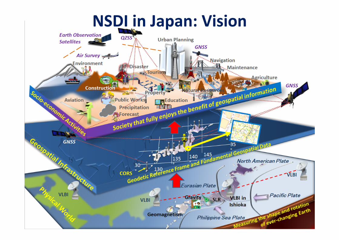
NSDI in Japan: Vision

Geospatial Information Authority of Japan (GSI)
NSDI in Japan: GoalTechnology, policies, and people necessary to promote geospatial data sharing throughout all levels of government, the private and non‐profit sectors, and academia. (http://www.fgdc.gov/nsdi/nsdi.html)
GovernmentsCentral
Municipalities
State
Industry
Academia
NPOs
CitizensGeospatial Information
Technology
Policies
People
Geospatial Information

Geospatial Information Authority of Japan (GSI)
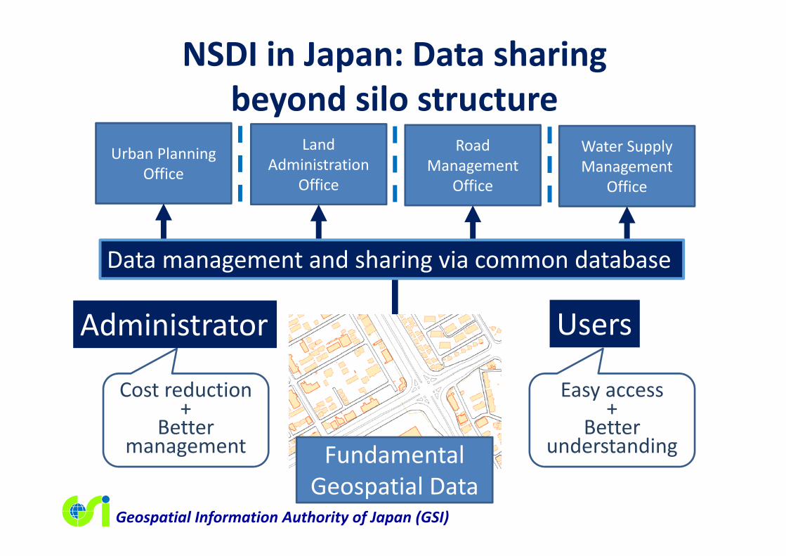
NSDI in Japan: Reality=Silos
Urban Planning Office
Land Administration
Office
Road Management
Office
Water Supply Management
Office
AdministratorDuplicated costs
Inefficient data sharing
Difficult to understand what’s going on in the organization
UsersStop duplicated efforts
Share data with us
Where is the data we need?
I’m not in trouble.
Different standards. Not for
disclosure.
Not in digital form.
Geospatial Information Authority of Japan (GSI)
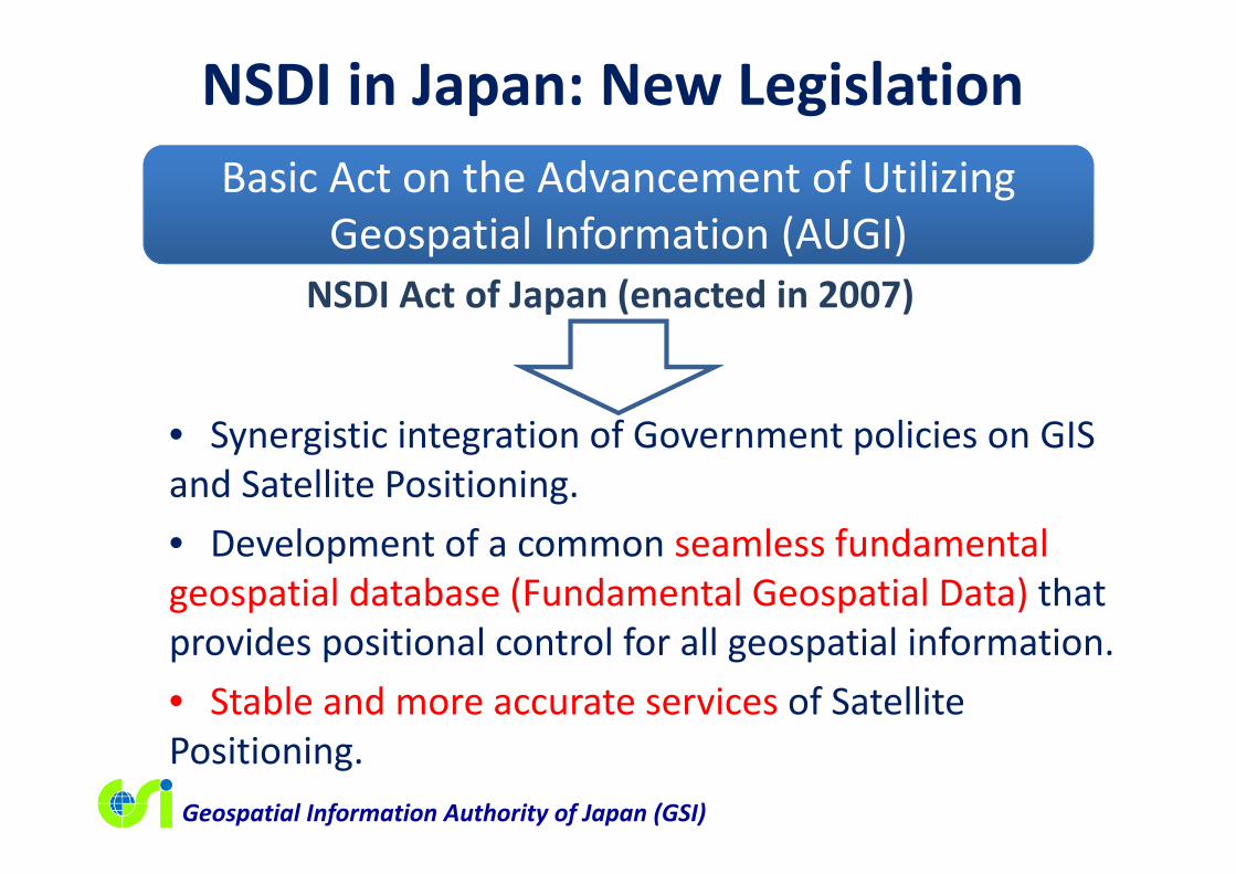
• Synergistic integration of Government policies on GIS and Satellite Positioning.• Development of a common seamless fundamental geospatial database (Fundamental Geospatial Data) that provides positional control for all geospatial information.• Stable and more accurate services of Satellite Positioning.
NSDI Act of Japan (enacted in 2007)
NSDI in Japan: New LegislationBasic Act on the Advancement of Utilizing
Geospatial Information (AUGI)
Geospatial Information Authority of Japan (GSI)
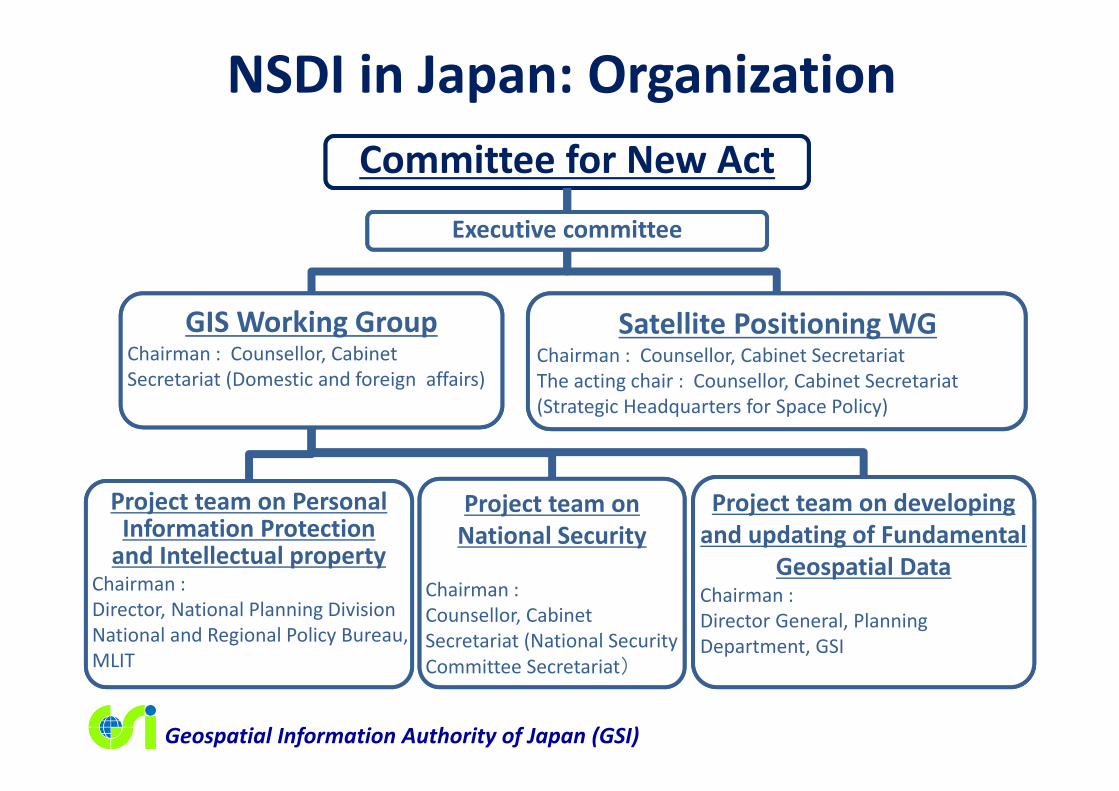
NSDI in Japan: OrganizationCommittee for New Act
Executive committee
GIS Working GroupChairman : Counsellor, Cabinet Secretariat (Domestic and foreign affairs)
Project team on Personal Information Protectionand Intellectual property
Chairman : Director, National Planning Division National and Regional Policy Bureau, MLIT
Satellite Positioning WGChairman : Counsellor, Cabinet SecretariatThe acting chair : Counsellor, Cabinet Secretariat(Strategic Headquarters for Space Policy)
Project team on National Security
Chairman : Counsellor, Cabinet Secretariat (National Security Committee Secretariat)
Project team on developing and updating of Fundamental
Geospatial DataChairman : Director General, Planning Department, GSI

Geospatial Information Authority of Japan (GSI)
Fundamental Geospatial Data
Geospatial Information Authority of Japan (GSI)
NSDI in Japan: Data sharing beyond silo structure
Urban Planning Office
Land Administration
Office
Road Management
Office
Water Supply Management
Office
Cost reduction+
Better management
Easy access+
Better understandingFundamental
Geospatial Data
Data management and sharing via common database
Administrator Users

UN-GGIM - What is it?

UN-GGIM - What is it?• GGIM: Global Geospatial Information management• UN initiative that provides a forum to liaise and
coordinate among Member States, and between Member States and international organizations in order to set the agenda for the development of global geospatial information and to promote its use to address key global challenges.
• Main forum: UN Committee of Experts on GGIM established by ECOSOC in July 2011.
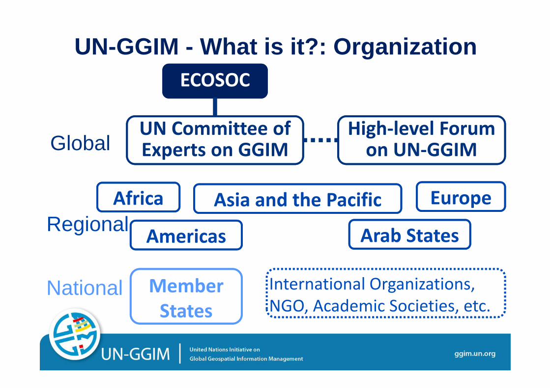
UN-GGIM - What is it?: Organization
UN Committee of UN Committee of Experts on GGIM
ECOSOC
level Forum High‐level Forum on UN‐GGIMGlobal
Africa
Americas
Asia and the Pacific
Arab States
EuropeRegional
NGO, Academic Societies, etc.International Organizations, NGO, Academic Societies, etc.
National Member States
Why UN-GGIM?
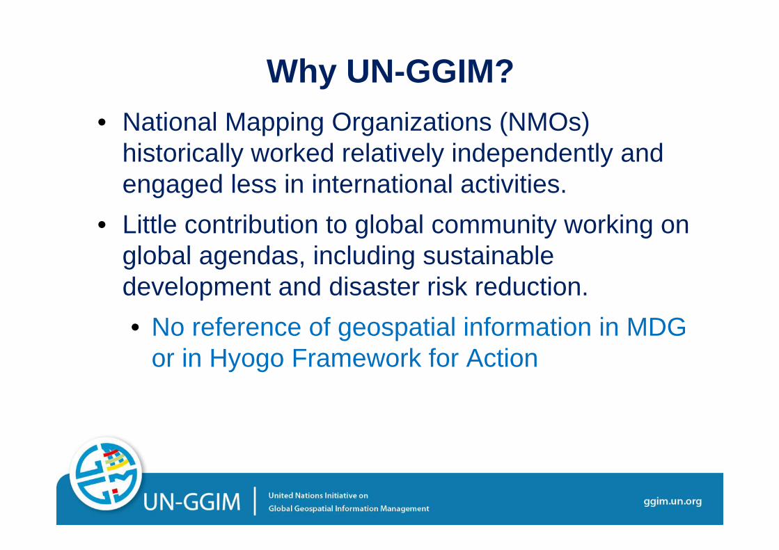
Why UN-GGIM?• National Mapping Organizations (NMOs)
historically worked relatively independently and engaged less in international activities.
• Little contribution to global community working on global agendas, including sustainable development and disaster risk reduction.• No reference of geospatial information in MDG
or in Hyogo Framework for Action
Why UN-GGIM?
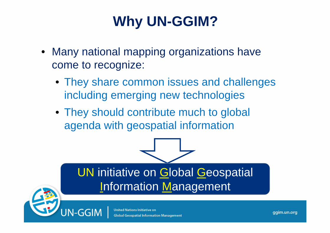
• Many national mapping organizations have come to recognize:• They share common issues and challenges
including emerging new technologies• They should contribute much to global
agenda with geospatial information
UN initiative on Global Geospatial Information Management
What is it Doing?
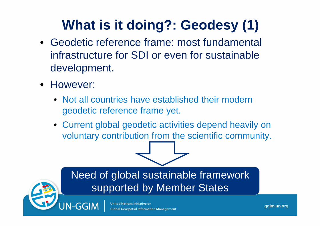
What is it doing?: Geodesy (1)• Geodetic reference frame: most fundamental
infrastructure for SDI or even for sustainable development.
• However:• Not all countries have established their modern
geodetic reference frame yet.• Current global geodetic activities depend heavily on
voluntary contribution from the scientific community.
Need of global sustainable framework supported by Member States

What is it doing?: Geodesy (2)• UNGA resolution (A/RES/69/266) “A Global
Geodetic Reference Frame for Sustainable Development” was adopted on 26 Feb. 2015.• Calling for greater multilateral cooperation on
geodesy, including the open sharing of geospatial data, further capacity-building in developing countries and the maintenance of appropriate national geodetic infrastructure.

What is it doing?: 2030 Agenda (1)• UN-GGIM engaged in post-2015 development
agenda starting from Rio+20 in 2012.• “We further recognize the importance of comprehensive
hazard and risk assessments, and knowledge and information sharing, including reliable geospatial information.”
• Not successful in putting specific reference of geospatial information in Sustainable Development Goals (SDGs).

What is it doing?: 2030 Agenda (2)• A reference was included in “2030 Agenda for
Sustainable Development.”• 76. We will support developing countries, particularly African
countries, LDCs, SIDS and LLDCs, in strengthening the capacity of national statistical offices and data systems to ensure access to high-quality, timely, reliable and disaggregated data. We will promote transparent and accountable scaling-up of appropriate public-private cooperation to exploit the contribution to be made by a wide range of data, including earth observation and geo-spatial information, while ensuring national ownership in supporting and tracking progress.
• UN-GGIM set up a working group to follow up on the indicators development.
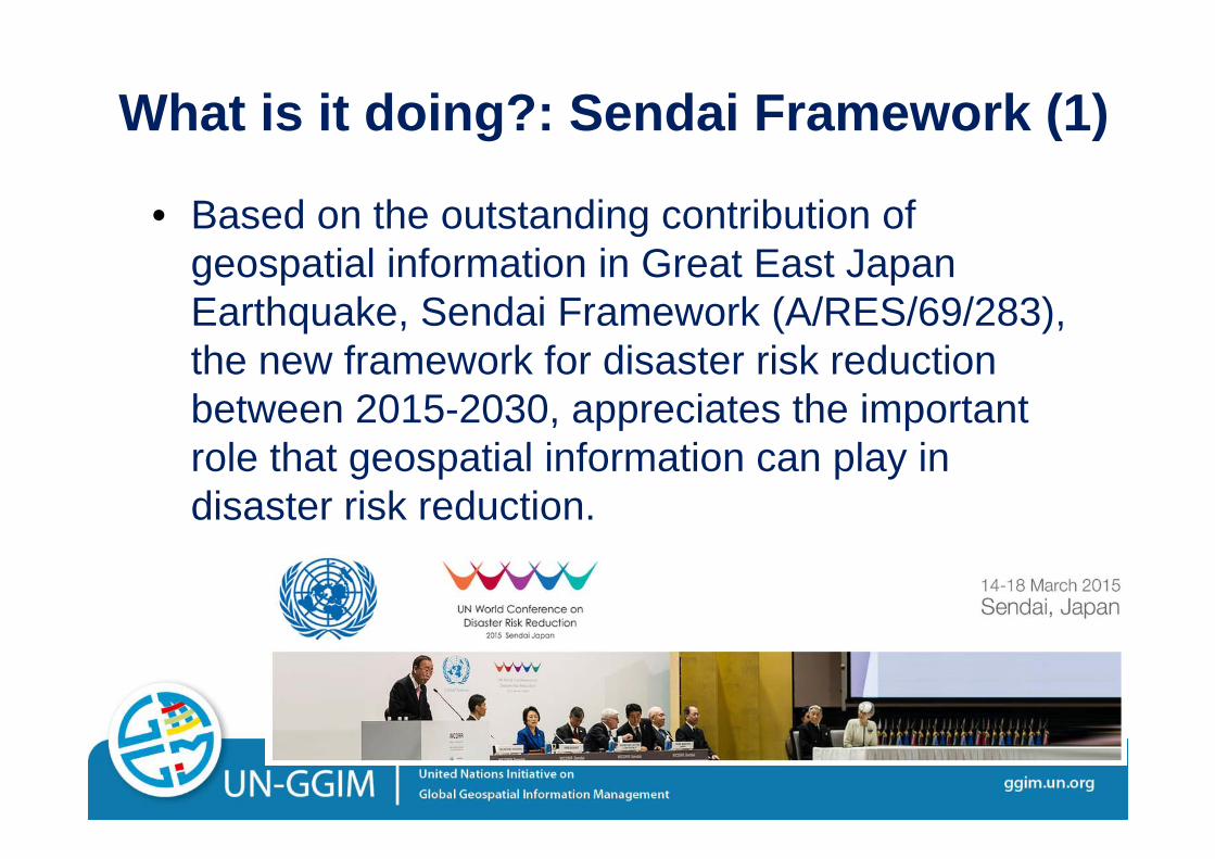
What is it doing?: Sendai Framework (1)
• Based on the outstanding contribution of geospatial information in Great East Japan Earthquake, Sendai Framework (A/RES/69/283), the new framework for disaster risk reduction between 2015-2030, appreciates the important role that geospatial information can play in disaster risk reduction.

What is it doing?: Sendai Framework (2)• Sendai Framework includes four specific
references on geospatial information.• “It is important to … Develop, periodically update and
disseminate, as appropriate, location-based disaster risk information, including risk maps, to decision makers, the general public and communities at risk of exposure to disaster in an appropriate format by using, as applicable, geospatial information technology.”
• UN-GGIM established a working group to study how the international community will be able to better prepare for and respond to emergencies.

What is it doing?: Other Topics (1)• Legal and policy frameworks
• Innovative geospatial services vs. privacy• Suitable legal framework for drones
• Standards for the global geospatial information community• Global dissemination of established technical
standards developed by ISO/TC211, OGC, IHO
• Global fundamental geospatial data themes• Most commonly used data themes among different
countries and regions
What is it doing?: Other Topics (2)• Integration of geospatial, statistical and other
information• Crucial element for successful implementation of
2030 Agenda.• In some countries, a single government organization
is in charge of both geospatial and statistical information.
• Land administration and management• Much interest expressed from developing countries.• In some countries, a single government organization
is in charge of both geospatial information and land management.
Geospatial Information Authority of Japan (GSI)
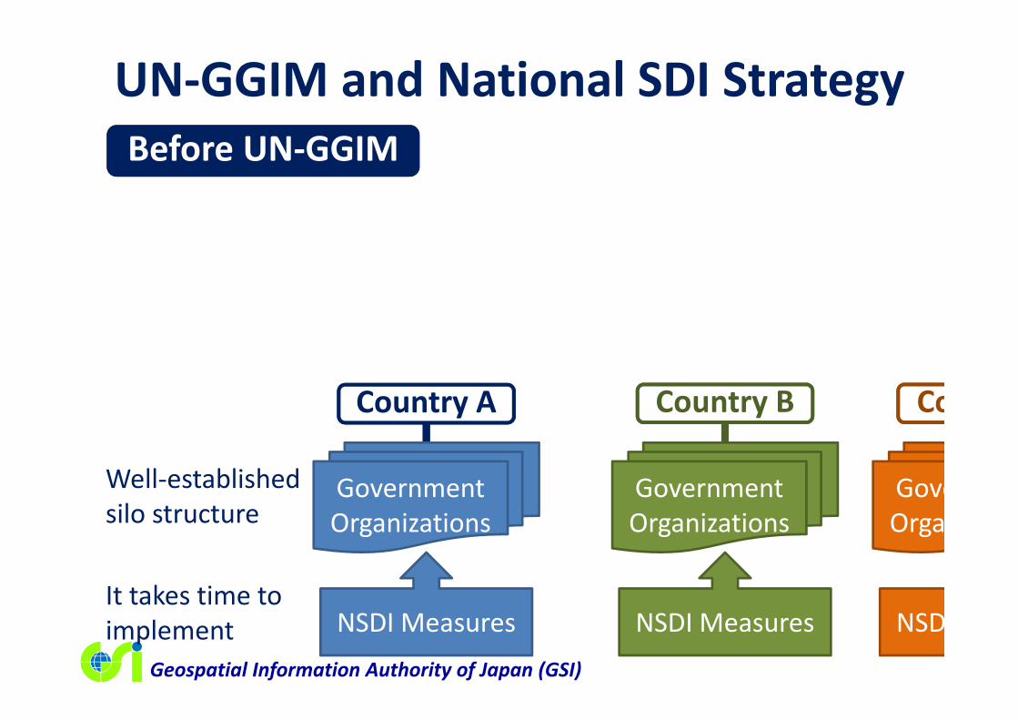
UN‐GGIM and National SDI StrategyBefore UN‐GGIM
Country A Country B
GovernmentOrganizations
NSDI Measures
Well‐established silo structure
It takes time to implement
GovernmentOrganizations
NSDI Measures
Co
GoveOrga
NSD

Geospatial Information Authority of Japan (GSI)
UN‐GGIM and National SDI StrategyAfter UN‐GGIM
Country A Country B
GovernmentOrganizations
NSDI Measures
Better understanding on NSDI
Accelerated implementation
GovernmentOrganizations
NSDI Measures
Co
GoveOrga
NSD
UNGA Resolutions, Best Practices, Global Standards, etc.
Geospatial Information Authority of Japan (GSI)
Summary• It takes time to fully implement SDI, particularly, in a well‐established governments and societies.
• UN‐GGIM, a newly established intergovernmental mechanism, will empower national mapping organizations to contribute more to national SDI development.
• UN‐GGIM will also contribute to the implementation of global agendas including 2030 Agenda and Sendai Framework.

Geospatial Information Authority of Japan (GSI)
Thank you!


