
GEOLOGICAL SURVEY W. E. Wrather, Director
Bulletin 935-D
TUNGSTEN DEPOSITS ISLA DE PINOS, CUBA
BY
LINCOLN R. PAGE AND JAMES F. McALLISTER
Geologic Investigation!! in tbe American Republics ' (Pages 177-246)
UNITED STATES
GOVERNMENT PRINTING OFFICE
WASHINGTON : 1944
For mle by tbe Superintendent of Doaonents. U. & GorennaeBt Fruiting Office. Waahingtott. D. C.Price $L25


CONTENTS
Abstract................................................ 177Introduction............................................ 178Geology................................................. 181
Rock formations..................................... 183Schist and quartzite............................ 183Pegmatite and quartz bodies..................... 184Feldspar-quartz porphyry........................ 185Rhyolite porphyry............................... 186Veins, breccias, silicified rocks, and tourma-
linized rocks................................. 187Mantle-.......................................... 187
Structure........................................... 188Folds........................................... 188Faults.......................................... 189Joints.......................................... 190
Summary of geologic events.......................... 190Ore deposits ...................................o.......o 191
Veins............................................... 192Quartz-tourmaline veins......................... 192Tourmalinized rock.............................. 193Silicified rocks................................ 194Ferberite-bearing breccia....................... 194
Placer deposits..................................... 196Mineralogy.... 0 .................................H .... 198Origin.............................................. 203Localization........................................ 204Size and grade...................................... 206Reserves............................................ 209
Mining and prospecting.................................. 210Lela claim.......................................... 210
Lela mine....................................... 210Pruneda shaft................. '. ................. 220Pruneda adit.................................... 223Calvache shaft.................................. 225No. 2 adit...................................... 226No. 3 adit...................................... 227Breccia area.................................... 231Northwestern area............................... 233Vanadium Corporation workings ................... 234
Genaro claim........................................ 236 'Aguedita claim...................................... 238Mercedes claim...................................... 240Ancash claim........................................ 241Fer-Mi claim........................................ 243Guido claim......................................... 244San Antonio and Rolando claims...................... 245Colorado claim...................................... 245
III
ILLUSTRATIONS
Page Plate 32. Index map, Siguanea district, Isla de Pinos,
Cuba....................................... 18033. Geologic map of the Siguanea district, Isla
de Pinos, Cuba........................ In pocket34. Geologic map and section of the Lela claim,
Isla de Pinos, Cuba................... In pocket35. Tourmalinized feldspar-quartz porphyry....... 18836. Detailed map of porphyry dikes north of the
- No. 2 adit on the Lela claim, Isla dePinos, Cuba................................ 188
37. Tourmalinized breccia........................ 19638. Coarse ferberite ore......................... 20439. Geologic map of the No. 1 adit, Lela claim,
Isla de Pinos, Cuba........................ 22040. Geologic map of the 125-foot and 225-foot
levels, Lela mine, Isla de Pinos, Cuba.................................. In pocket
41. Geologic map of the Pruneda adit, Lelaclaim, Isla de Pinos, Cuba................. 228
42. Geologic map of the No. 2 and No. 3 adits,Leia claim, Isla de Pinos, Cuba............ 228
43. Detailed map of the ferberite breccia area onthe Lela claim, Isla de Pinos, Cuba... In pocket
TABLES
Table 7. Dimensions of mineralized bodies, Lela mine,
IV
Page 207

TUNGSTEN DEPOSITS, ISLA DE PINOS, CUBA
By Lincoln R. Page and James F. McAllister
ABSTRACT
The tungsten deposits of the Isla de Pinos, Cuba, occur in the southwestern part of the island, near the Lonas de Siguanea. They are about 30 miles (50 km.)!/ by dirt road south of Nueva Gerona, the main port of the island. The Pan- American Tungsten Corporation (Corporacion Pan-Americana de Tungsteno, S. A.), which owns the Lela or Mina Lela claim, is the only operator in the Siguanea district. Nine other claims have been staked in the district, but development has been limited to small prospect trenches and pits.
The dominant rocks of the district are isoclinally folded fissile biotite and muscovite schists, which in places grade imperceptibly into quartz-mica schists and quartzites. These rocks vary in strike and, in general, dip 20° to 30°. They have been cut by small faults and in places are strongly brec- ciated. One of the most common structures in the schists and quartzites is a well-developed system of joints (sheeting) that strike N. 10°-25° E. and dip 75° to 90°.
Igneous rocks of three ages have been intruded into the metamorphic rocks of the district. The oldest are thin pegma tite dikes, which are associated with large barren quartz masses. The most abundant igneous ro'ck is feldspar-quartz porphyry, which occurs in dikes that strike from.a few degrees west of north to about N. 30° E. and dip as much as 75° to 9.0°. It is older than the tungsten veins, and the veins are cut by dikes of rhyolite porphyry, which were intruded along the veins and along fractures that strike II. 45°-55° W. The rhyolite is rarely well exposed, being easily weathered.
The chief ore mineral, ferberite, occurs in quartz-tourma line veins and in tourmalinized and silicified breccia, feld spar-quartz porphyry, schist, and quartzite. A little scheel- ite.has been formed by alteration of ferberite. Some allu vial, residual, and marine sedimentary deposits may contain appreciable amounts of detrital ferberite.
The tungsten deposits are foxind in an area about 12,000 feet (3'.7 km.) long and 5,000 feet (1.5 km.) wide, but most occurrences of possible economic importance are localised in an area approximately 6,000 feet (1.8 Ion.) long and 2,800 feet (0.05 km.) wide. Northeast of this.area the mineral deposits are of the sulfide type and are indicated on the surface as gossan. Many veins are exposed in the district, and 37 of the most promising, all on the Lela claim, have been described in
\J Where the English measures represent rough estimates, their metric equivalents ere given only approximately and usually In round numbers.
177

178 GEOLOGIC INVESTIGATIONS IN THE AMERICAN REPUBLICS
detail. The veins strike from a few degrees west of north to N. 40° E., but most of them strike between N. 10° E. and N. 25° E. and form a fanlike pattern diverging to the north east. In general the veins dip 50° or more toward the central part of the mineralized area, but there are many exceptions. Most of the veins are less than 5 feet (1.5 m.) thick, but some are about 12 feet (3.6 m.) thick. The individual veins differ greatly in length, but some can be traced as much as 1,500 feet (460 m.) along the strike.
In the Lela mine at least six tungsten-bearing quartz bodies have been prospected by more than a mile of underground workings at the 125- and 225-foot levels. The only other development work of importance is on the Pruneda vein, about 1,400 feet (425 m.) west of the Lela mine. Here a shaft has been sunk to the 200-foot level and is being connected with the Lela workings. The property is equipped with a 200- to 250-ton mill, which has not yet begun prodxiction.
The tungsten reserves of the Siguanea district appear to be fairly large, but at the time of the examination not enough work had been done to serve as a basis for satisfactory esti mation of potential tonnages and grade. At that time the reserve of tungsten ore was roughly estimated, without benefit of sampling data, at 55,000 tons containing about 750 tons of WOs- On the basis of recent developments, however, it appears probable that the reserve of ore is larger than this, and with continued development even larger reserves may be proved.
INTRODUCTION
Isla de Pinos, with an area of 1,214 square miles, is
about 60 miles (100 km.) south of the main island of Cuba,
between 21° and 22° north latitude and 82° and 83° 15' west
longitude. Tungsten deposits occur on the southwestern part
of the island, near Lomas de Siguanea, which is at the head of
the Ensenada de la Siguanea (pi. 32).
Tungsten is being developed only at the Lela mine, oper
ated by the Pan-American Tungsten Corporation (Corporacion
Pan-Americana de Tungsteno, S. A.). The settlement of
Siguanea is connected by 30 miles (50 km.) of dirt road with
Nueva Gerona, the -main port, which is at the north end of the
island. All equipment and supplies used on the island are
shipped from Habana or other ports on the island of Cuba by
railroad to Batabano, where they are reshipped by boat. The
mining supplies used by the Pan-American "Tungsten Corporation
are now transported by truck from Nueva Gerona, although some ,
of the heavier machinery was brought on small fishing schoon
ers to a dock within 3 kilometers of the mine.

TUNGSTEN DEPOSITS, ISLA DE PINOS, CUBA 179
Unconfirmed reports indicate that tungsten minerals were
first recognized on the Lela claim as early as 1900, but the
first known discovery of these minerals was made by George
Tower, Laurence Litchfield, and T. C. Denton while they were
prospecting the island in the summer of 1927 for the company
operating the Field gold mine, in the western part of the
Island. In the summer of 1928 a claim was staked by Litch
field and Denton, who optioned the property to the Vanadium
Corporation of America. In 1929, after a few prospect
trenches and pits had been dug, the claim was allowed to
lapse. In 1938, Engineer Antonio Calvache, of Habana, Cuba,
recognized tungsten minerals in samples from this area submit
ted by Jesus A. Estrella, Guido Calvache, and Rafael Rivis,
and advised them of its economic possibilities. Estrella
immediately located the claim now known as the Mina Lela or
Lela claim. The Molybdenum Corporation of America did a lit
tle prospecting on the claim in the fall of 1938. In February
1939, the property was acquired from the-Cuban interests by
S. C. E. Melkman, and the -Pan-American Tungsten Corporation
(Corporacion Pan-Americana de Tungsteno, So A.) was then
formed. Underground development was started immediately and a
mill was erected, which in 1939 produced about 2 tons of con
centrates. In 1940 the control of the company passed to
Mr. W. M. Archibald, who is at present directing mining opera
tions. The mill, which has been shut down since the initial
period of operation, was redesigned in 1941 and 1942 to handle
as much as 200 to 250.tons of crude ore per day.
After the discovery of the Lela property, Jesus A. Estrella
staked the claims known as the Genaro, Rolando, Ancash, and
Fer-Mi on recommendation of Engineer Calvache, and .on his own
initiative restaked the Guido and Cancio claims. At about the
same time, Eduardo Escribano staked the Aguedita and Louis
Pozo the Mercedes claim.

180 GEOLOGIC INVESTIGATIONS IN THE AMERICAN REPUBLICS
2/ The tungsten deposits were described "by Calvache ' in
1939 and 1940, and were later mentioned by Corral.^/ The gen
eral- geology of the island is incompletely known, but some
phases of it have been discussed by Hayes, Vaughan, and
Spencer, / Alien, / Suarez llurias, / Brown and 0 f Connell, '
Allende, ' But ten, / and Schuchert. =/ Maps of the island were
published l>y Pernandez de Castro and Salterain y Legarra in
1844, in the bulletin of the Commision del llapa Geologico de
Espana, Madrid, and also by Lewis. /
The tungsten deposits of the Siguanea district were exam
ined by the Geological Survey during a four-month period
extending from July to November 1941. The work formed a part
of the Department of State's program of cooperation with Amer
ican ^Republics, and was done in collaboration with the Direc-
cion de Monies, HInas, y Aguas of the Cuban Government. A
topographic and geologic map, representing an area of about one
square mile (259 hectares) which Included the Lela claim, was
made with the telescopic alidade and plane table on a scale of
200 feet to the Inch (1:2,400), and a map on a scale of 1,000
£/ Cfilvache, .Antonio, Ttm^teno en Isla de Pinos: Bevista de Agricul ture, no. 22, pp. 41-44, :Enero 1939; Estado de la minerie en Cuba al finalizer el EDO 1939, p. 9, JJabana. Editora de libros y Folletos, 1940.
_3/ Corral, Jose Isaac del, la miners Cubans: sus industries racion- ales. flevista de la Soc. Cubans de Ing,, no. 37, pp. 43-43, 1942.
4/ Hayes, 3. W., Yaughen, T.. C,, and Spencer, A. C., Report on a geo logical reconnaissance of Cuba. Made under the direction of General Leonard Wood, in civil report of Brig.-Gen. Xeonard Wood, military gover nor of Cuba, for the period irom January 1 to December 31, 1901, vol. 1, pp. 9-10, pp. 112-117, 1901.
5/ Alien, G. M., Fossil mammals from Cuba: flarvard Coll., Mus, Comp. Zool., Bull. 62, pp. 133-148, 1918.
_&/ Suarez liuriBS, E. U., Visits de inspeciou a la Isla de Pinos, Cuba: Direc. de Montes y Miaas,. Hal. Minas, no, 6, pp. 24-28, 1920.
7/ Brown, Barnuta, anfi 0^Cornell, TJIajorie, Correlation of the Jurassic formations of western Cuba: Geol. Soc. America, Bu]l., vol. 33, pp. 539- 654, 1922.
B/ Allende, Roque, Estudio tecnico de los yacimientos minerales de Isla de Pinos, Cuba: Direc. de Monies y Minas, Bol. Minas, no, 7, pp. 51-67, 1923.
9/ Eutten, L. Ti3. P., Geology of Isla fle Pinos, Cuba: K. Akad. Wetensch Amsterdam, Sec. Sci,. Proc,, vol. 37, no. 7, pp. 401-406, 1934.
10/ Schuchert, Charles, Historical 4geology of the Antillcan-Caribbean region, pp. 48B-4B9, p, 518, pp. 523-525, Itew York, 1935.
ll/ Lewis, J, Whitney,-eeology of Cuba: ^m, Assoc. Petroleum Geolo gists Bull., vol. 16, pp. 533-£5a, 1932.

GEOLOGICAL SURVEY BULLETIN 935 PLATE 32
SIGUAN DISTRICT
Ensenada de laSiguanea
aoMiles ' Millas
25 Kilometers ~* Kildmetros
INDEX MAP, SIGUANEA DISTRICT, ISLA DE PINOS, CUBA MAP A INDICE, GOTO DE LA SIGUANEA, ISLA DE PINOS,
CUBA

181
feet to the inch (1:12,000) was made of a tract % to 1 mile
(0.8 to 1.6 km.) wide and 5 miles (0 km.) long, which forms' a
northeastward extension of the mineralized area. Underground
maps were made on a scale of 50 feet to the inch (1:600). All
reported occurrences of tungsten minerals were examined in the
Genaro, Aguedita, San Antonio, Rolando, Ancash, Fer-Hi, Guido,
Cancio, Mercedes, and Colorado claims, but only the more prom
ising areas were mapped in detail.
The writers are indebted to the officials of the Pan-
American Tungsten Corporation, especially Mr. W. M. Archibald
and Senor Louis Pozo, president of the corporation, for their
cooperation throughout the period of field work and for fur
nishing the party with living quarters. Information relative
to the development work done on their property since comple
tion of the field work has been made available by Mr. Archi
bald. Senor Antonio Calvache kindly lent maps from his per
sonal files and gave detailed information concerning the early
history and development of the district, and courteously gave
his assistance, as representative of the Cuban Government, in
arranging necessary interviews. Transportation between Habana
and Isla de Pinos was furnished by the Cuban Government.
Senor Eduardo Escribano, of Nueva Gerona, Mr. Nesbit S. Alien,
of Habana, Senor Jesus A. Estrella, and others who owned
claims in the district kindly made available information con
cerning their respective properties.
GEOLOGY
The metamorphic rocks that make up a large part of Isla de
Pinos include a wide variety of schists interbedded with
quartzites and marbles. / In the district studied, the cal
careous members are absent. Here the rocks are fissile bio-
tite and muscovite schists, which in places grade imperceptibly
lg/ Rutten, L. M. R., op. cit.
562263 O - 4 3 - 2

182 GEOLOGIC INVESTIGATIONS IN THE. AMERICAN REPUBLICS
into quartz-mica schists and quartzites. These rocks, proba
bly marine sediments originally, were called the Santa Pe
13/ schist and Genaro marble by Hayes. ' More recent writers
have correlated them, entirely on the basis of lithologic sim
ilarity, with the San Cayetano formation of Pinar del Rio
Province, on the island of Cuba. The San Cayetano formation
14 / has been supposed to contain Middle Jurassic fossils, ' but
there has been a controversy as to whether the diagnostic fos
sils are from the San Cayetano formation or from the overlying
Vinales limestone. '
The metamorphic rocks of Isla de Pinos are intruded by
igneous rocks of at least three and perhaps four different
ages. The oldest of these, called diorite schist by Hayes /
17/ and araphibolite by Rutten, ' was intruded before the regional
metamorphism, which in Pinar del Rio Province is believed to
be of late Jurassic age-. It has been found southeast of Santa
Fe but was not observed in the Siguanea district, where the
oldest igneous rocks are thin pegmatite dikes, associated with
large barren quartz masses. The most abundant dike rock is
feldspar-quartz porphyry. This rock is older than the tung
sten veins, but the veins are cut by younger dikes of rhyolite
porphyry.
The tungsten deposits, which are all characterized by fer-
berite, are quartz-tourmaline veins and tourmalinized and
silicified breccias, schist, and quartzite. The rocks adja
cent to the veins are well jointed, faulted, and partly
replaced by quartz and tourmaline.
13/ Hayes, C. W,, Vaughan, T. C., and Spencer, T. W., op. cit., pp. 114-1L5.
14/ Dickerson, R. E., and Butt, W. H., Cuban Jurassic: Am. Assoc. Petroleum Geologists Bull., vol. 19, pp. 116-118, 1935.
Irolay, R. W., Late Jurassic fossils from Cuba and their economic significance: U. S. Ceol. Survey, manuscript in preparation, 1942.
15/ Brown, 3arnum, and O'Connell, Marjorie, op. cit.16/ Hayes, C. W., Veughan, T. W., and Spencer, A. C., op. cit., p. 115.IT/ Rutten, L. M. R., op. cit., p. 403.

TUNGSTEN DEPOSITS, ISLA DE PINOS, CUBA 183
Erosion has reduced the greater part' of the island to a
gently rolling plain, 50 to 200 feet (15 to 60 m.) above sea
level, but around its fringes marine deposits of sand, clay,
and gravel extend to altitudes of 20 to 30 feet (6 to 9m.).
These marine deposits merge with alluvium at their upper edge
and include areas of ferruginous conglomerate, thought to have
formed by precipitation of iron oxide in swamps or from spring
water.
Rock formations
Schist and quartzite.--Mica schists underlie the larger
part of the areas mapped (see pis. 33 and 34). In general
these are poorly exposed; the observed outcrops are mostly of
schist that is rich in quartz or has been silicified or tour-
malinized by hydrothermal solutions. The fresh rock obtained
from underground workings is dark gray to black and contains
biotite, musoovite, and quartz> together with less feldspar,
staurolite, kyanite, zircon, titanite, and apatite. The rela
tive abundance of these minerals differs in different beds,
but by far the greatest difference between beds is in the per
centage of quartz. The schists have been weathered in places
to a depth of 150 feet (45 m.), and are usually stained yel
lowish to red with iron oxide. Near the' veins, introduction
to tourmaline along the bedding or foliation planes,has in
places produced tourmaline schists and gneisses composed
almost entirely of quartz and tourmaline. Sillcification
along the veins has converted the schists into hard cherty
rocks which in places are similar to the quartzites.
The quartzites are most prominent east of the brecciated
zone shown on plate 34, in the southeastern part of the Lomas
de Siguanea, and along the southern edge of the adjacent hills.
Quartzite is also exposed along the boundary between the

184 GEOLOGIC INVESTIGATIONS IN THE AMERICAN REPUBLICS
Genaro and Aguedita claims, In the Ancash claim, and as thick
beds in cliffs on the Sierra de la Canada.
The quartzites are for the most part micaceous and grade
both laterally and vertically into schists. The beds of
quartzite are lenticular and it was found impracticable to map
them separately, but the approximate distribution of the
quartzite is shown on the map. The fresh rock is light-gray
to buff; upon weathering it becomes lighter colored except
where stained by iron oxide.
Pegmatite and quartz bodies.--Numerous thin quartz-feld
spar pegmatite dikes and associated small barren massive
quartz lenses lie parallel to the bedding and foliation of the
schists in the underground workings on the Lela claim. The
pegmatite rarely contains muscovite, and feldspar usually
forms less than half of the rock, being in places entirely
absent. The dikes, where observed, are usually less than a
foot (0.3 m.) thick, and in cross section they appear as a
series of connected or disconnected lenses or podlike bodies.
Pegmatite was not definitely recognized on the surface, but it
may be represented by similarly shaped bodies of quartz, which
before weathering may have contained feldspar.
Other areas (pi. 33),'particularly the Guido claim, con
tain many large lenticular to tabular bodies of barren milky
quartz, some of which are as much as 700 feet (210 m.) long
and 60 feet (18 m.) wide, although in general they are less
than 25 feet (7.5 m.) wide. The smaller bodies lie parallel
to the foliation of the schists, but many of the larger ones
cut across the structure.
Cassiterite is said to be present in one of these quartz
bodies on the Guido claim-, i2/ but none was observed by the
writers, who found only black tourmaline, fractured and veined
with quartz, rutile, and occasional muscovite as original
18/ Calvache, Antonio, oral discussion.

TUNGSTEN DEPOSITS, ISLA DE PINOS, CUBA 185
minerals accompanying the quartz. Iron oxides are sparingly
present, and green tourmaline in thin needlelike crystals and
aggregates may be seen in a few of the outcrops, being most
abundant where the sulfide-tourmaline veins cross or intersect
the quartz masses. In some places\there are cavities contain
ing euhedral crystals of quartz, which may be coated with
these needles of tourmaline.
Feldspar-quartz porphyry.--The feldspar-quartz porphyry
dikes (pi. 34) are irregular in shape, but most of them are
tabular and strike from a few degrees west of north to about
N. 30° E. A few strike as much as 45° west of north. Accu
rate dips on most of the dikes are not obtainable because of
poor exposures and local irregularities of the contacts, but
many of the dikes have dips as steep as 75° and some appear to
be nearly vertical. On the map (pi. 34) some of them are
represented as branching, but at some places it is not possi
ble to determine whether a dike actually forks or two dikes
cross one another.
The older dikes of feldspar-quartz porphyry consist mainly
of conspicuous phenocrysts of orthoclase and quartz in a greenish-gray, very fine grained groundmass, but they contain
smaller phenocrysts of sericitized oligoclase and partly
chloritized biotite. Their groundmasses consist of very small
grains (commonly 0.03 mm.) of orthoclase and quartz, with
accessory garnet. In composition the older porphyry is proba
bly in part latitic, and in part rhyolitic. It is distin
guished from the younger rhyolite porphyry by its coarser tex
ture, its more abundant and larger phenocrysts, and the pre
dominance of feldspar phenocrysts over quartz.phenocrysts.
Some of the feldspar-quartz porphyry was altered during
the tungsten mineralization In such a way that tourmaline has
replaced the groundmass without altering the phenocrysts; in
some of it, on the other hand, the feldspar phenocrysts have

186 GEOLOGIC INVESTIGATIONS IN THE AMERICAN REPUBLICS
been selectively replaced by tourmaline, making them conspicu
ous in a white groundmass that has not been replaced (see pi.
35). Some of the well-defined quartz-tourmaline veins, where
they enter the porphyry, split up into numerous tourmaline
veinlets, which lose their identity in a broader mass of black
mineralized porphyry.
In the silicified areas on the south side of Lomas de la
Siguanea, the porphyry crops out as a greenish to white cherty
rock that shows the original texture and minerals in various
degrees of preservation. In the more completely silicified
areas the porphyry cannot be distinguished from silicified
metamorphic rock. .
Rhyolite porphyry. The rhyolite porphyry of the later
dikes is the youngest igneous rock in the Siguanea district.
As shown in plates 34 and 36, it cuts the feldspar-quartz por
phyry and the tungsten-bearing veins. Some of these dikes
follow fractures that diagonally cross the vein system,
whereas others have followed the Pruneda and other veins,
splitting a vein in the middle at some places instead of fol
lowing either wall. One dike of this group (pi. 36) has a
peculiar blocky outcrop and ends abruptly on the surface,
though it apparently continues underground without a change in
thickness.
The rhyolite porphyries are more regular in strike and dip
than the feldspar-quartz porphyries, and their position can be
predicted fairly successfully in advance of mining. The regu
larity is illxxstrated in the Lela mine (pi. 40), where a 3- to
4-foot (0.9 to 1.2 m.) dike maintains a nearly straight course
of H. 55° W. and dips 80° SW. to 80° NE. across the explored
area.
The rhyolite porphyry is rarely well exposed, for it is
easily weathered, being completely decomposed even on the 125-
foot level of the Lela mine. The weathered rock is a buff to

TUNGSTEN DEPOSITS, ISLA DE PINOS, CUBA 187
light-gray, fine-grained porphyry with scattered phenocrysts
of quartz and*kaolinized feldspar. Dark grains of iron oxide,
derived from completely altered biotite or hornblende, are
disseminated in a very fine grained groundmass of secondary
quartz. Dark-reddish to purplish iron oxide usually stains
the surface exposures. At one place on the ridge northeast of
the No. 3 adit, a little tourmaline, apparently introduced,
was observed in a dike of this rock.
The least altered specimen, from a dike on the 225-foot
level of the Lela mine, is buff to brown and fine-grained. It
contains scattered phenocrysts of quartz, rounded and corroded,
in a matrix of carbonate, fine-grained quartz, iron oxide, and
sericite. The lathlike shape of the original feldspar crys
tals is preserved by aggregates of sericite and quartz. This
rock may be a hydrothermally altered latite porphyry.
Veins, breccias, silicified rocks, and tourmalinized
rocks.--(See pis. 33, 34, and 43). The ferberite-bearing
quartz-tourmaline veins and associated sulfide veins, ferber
ite-bearing breccias, and silicified and tourmalinized rocks
are described in detail in the section of this report dealing
with ore deposits, pages 191 to 210.
Mantle. Surface deposits of clay, sand, gravel, bog iron,
and ferruginous conglomerate cover a considerable part of the
Siguanea. district. On the map of the district (pi. 33) only
the ferruginous conglomerate is distinguished by a special
pattern, all the other surficial deposits being represented by
one other pattern. Clay, sand, and gravel, at least in part
marine, cover most of the surface below the 20-foot contour,
above which clay and fine sand extend up shallow, nearly flat
valleys to an altitude of 100 feet (30 m.-) or more. The
gentle slopes near the divides are paved with residual gravel,
as much as 3 feet (1m.) thick, from which the fine material
has been removed by sheet wash. Some of the gravel,

188 GEOLOGIC INVESTIGATIONS IN THE AMERICAN REPUBLICS
irregularly distributed between 20 and 55 feet (6 and 15 n.)
above sea level, is cemented by iron oxide derived from
springs.and perhaps bogs.
The alluvium shown on the map of the Lela claim (pi. 34)
includes some marine deposit's and iron-cemented conglomerate.
Slope rubble and residual material cover parts of areas desig
nated as schist and quartzite.
Structure
The isoclinally folded schists and quartzites of the
Siguanea district appear to be on the eastern flank of a large
anticlinal or arched structure. Poor exposures, limitations
of time, and absence of good horizon markers in the metamor-
phic rocks made it impossible to map even the major structures
in detail. These structures are complicated by at least three
systems of faults and fractures and by three groups of igneous
intrusions.
Folds.--It was probably at the end of the Jurassic period
that the rocks of the Siguanea district were metamorphosed and
isoclinally folded. The foliation, which is essentially par
allel to the bedding, is followed by many of the pegmatite
dikes and by the associated thin quartz lenses.
The structure in the Lomas de Siguanea, though complicated
by many minor isoclinal folds and faults, appears to be in
general anticlinal. In the western part of this area most of
the schist strikes N. 10°-35° W. and dips 20°-30° SW., but
eastward its attitude gradually changes, so that in the east
ern part of the area it strikes N. 60°-80° E. and dips 20°-30°
SE. The broad low ridge extending northeastward from Siguanea
to the Sierra de la Canada may be on the axis of this anti
cline, ^but minor folds, faults, and lack of outcrops make the
structure at this locality obscure. The schists in the south
eastern part of Sierra de la Canada have, in general, a strike

GEOLOGICAL SURVEY BULLETIN 935 PLATE 35
f* *--v'£?feJ
TOURMALIMZED FELDSPAR-QUARTZ PORPHYRY.
Feldspar-quartz porphyry showing feldspar phenocrysts replaced hy tourmaline (black); rounded and corroded quartz phenocryets (gray); and kaolinized groundraass (white).From the 225-foot level of the Lela mine.

GEOLOGICAL SURVEY BULLETIN 986 PLATE 86
100 i Pies
10LL
10 30 Metros
EXPLANATION
Schist and quartzite
Feldspar-quartz porphyry
Rhyolite porphyry
Quartz-tourmaline veins
Tourmalinized rock
Silicified rock
Strike and dip of bedding and foliation
Fault, showing dip
Pit
Triangulation station
60
EXPLICA CION
Esquistos y cuarcita
Porfido de teldespato y cuarzo
Porfido riolftico
Vet as de cuarzo y fur ma I in a
Roca furma/in/zada
Roc a silicificado
Rum,bo y buzamiento .de estra- tificacion y foliacion
Fa I la, indicando su buzamiento
Calicata
Ve'rtice de triangulacio'n
DETAILED MAP OF PORPHYRY DIKES NORTH OF THE NO. 2 ADIT ON THE LELA CLAIM, ISLA DE PINOS, CUBA
PLANO DETALLADO DE LOS DIQUES DE PORFIDO AL NORTE DEL SOCAVON NO. 2, CONCESION LELA, ISLA DE PINOS, CUBA

TUNGSTEN DEPOSITS, ISLA DE PINOS, CUBA 189
of N. 10°-20° W. and dip 20°-25° NE.; those in the northern
part strike N. 60°-70° W. and dip 5°-20° NE. Minor isoclinal
folds are well exposed in the underground workings on the Lela
claim. The pitch of their axes, where measured, is 15°-25° SE.
Faults.--A number of faults were observed in the Siguanea
district, but their exposures are discontinuous and do not in
most places permit accurate determination of the attitude or
amount of offset. There is evidence of at least three main
periods of faulting and fracturing, which followed the meta-
morphism and folding of the original rocks. The earliest
fracture system, probably developed'shortly after the folding,
localized the pegmatite and barren qxiartz bodies that cross
the structure of the schists in the Guido and other claims.
The second period of faulting started before the tungsten
mineralization and continued intermittently until the last of
the vein-forming minerals" were deposited. The earliest stage
of this deformation probably was marked by the formation of
breccia bodies and of the fractures along which the feldspar-
quartz porphyry dikes were intruded. Later the porphyry dikes
were cut by faults with offsets of a few feet. The fan-shaped
system of faults and fractures now filled with quartz-tourma
line veins was superimposed on these earlier structures.
After deposition of the early quartz and ferberite of the
veins, fracturing and faulting was renewed, for this early
vein material is brecciated. Sheeting structures were proba
bly developed at this time and were later mineralized with
tourmaline, ferberite, and sulfides. Faulting and fracturing
occurred along these same trends after the introduction of
tourmaline. Strike faults extend along many of the veins, but
there is little displacement on them. Some are filled by late
rhyolite porphyry dikes, and sulfides have been introduced
along others. The wide brecciated zone, now heavily iron-
stained, east of the Lela shaft, was probably formed at this
562263 O - 43 - 3

190 GEOLOGIC INVESTIGATIONS IN THE AMERICAN REPUBLICS
time. Probably at the same time, also, the fractures and
faults striking N. 35°-55° W. were formed that in some places
cross the veins and feldspar-quartz porphyry dikes. In the
Lela mine one of these is followed by a rhyolite porphyry dike.
Joints.--One of the structures most common in the schists
and quartzites is a well-developed system of joints that
strike N. 10°-25° E. and dip 75°-90° SE. or NW. Where the
joints are especially numerous and closely spaced 1 to 3
inches (2.5-7.5 cm.) apart they have been called sheeting.
Sheeting is especially prominent in the rocks on the 125-foot
level of the Lela mine, where it makes a small angle with the
veins. Here tourmaline, ferberite, sulfides, and, more rarely,
silicification, have followed the sheeting. Sheeting is not
as prominent on the lower level of the mine.
Less regularly spaced joints cross the sheeting but are
not numerous. The porphyries are not sheeted; they are broken
into large irregular blocks by unsystematic joints, which are
so open that the dikes act as channelways for large quantities
of water.
Summary of geologic events
Although field relations observed within the Siguanea dis
trict make it possible to work out the sequence of geologic
events in the district, they do not serve to date these events
according to the geologic time table. All geologic dates are
necessarily based on similar tentative correlation with rocks
on the mainland of Cuba, where the seqxience of events has been
worked out by other writers. The sequence as indicated by
evidence in the Siguanea and adjacent areas is as follows:
1. Deposition of a thick series of interbedded sand,
clay, and sandy clay, probably in Jurassic time.
2. Intrusion of diorite.

TUNGSTEN DEPOSITS, ISLA DE PINOS, CUBA '191
3. Regional nietamorphism and deformation of the sediments
and diorite, probably at the end of Jurassic tine.
4. Emplacement of massive quartz bodies and pegmatites
along foliation planes, isoclinal folds, and fractures.
5. Brecciation and faulting, closely, followed by intru
sion of feldspar-quartz porphyry, which was probably accompa
nied by some silicification of breccias and other rocks. The
age of the intrusions is unknown but may be late Cretaceous or
early Tertiary.
6'. Additional faulting and hydrothermal alteration,
including the main tungsten mineralization of the area.
Quartz-ferberite veins were formed and were later fractured
and brecciated. The sheeting structure was developed before
the final introd\iction of tourmaline, ferberite, quartz,
arsenides, and sulfides. Fractures and faults that were
formed after the deposition\of most of the tourmaline were\
later mineralized with pyrite.
7. Intrusion of rhyolite porphyry dikes, both along the
strike and diagonally across the trend of the vein system,
marking the end of the main period of mineralization. The
presence of carbonates in the dikes suggests some later hydro-
thermal alterations.
8. Subaerial erosion and the deposition of marine sands
and gravels.
9. Deposition of alluvial material, formation of residual
deposits, ferruginous conglomerates, and gossan caps.
ORE DEPOSITS
The most promising tungsten deposits are in the southern
part of the Siguanea district Ferberite and scheelite
formed during late stages of the mineralization occur in
quartz-tourmaline veins, tourmalinized breccia, silicified

192 GEOLOGIC INVESTIGATIONS IN THE AMERICAN REPUBLICS.
breccia, silicified and tourmalin!zed schist, quartzite, and
feldspar-quartz porphyry. Some ferberite occurs in the surfi-
cial deposits derived from these altered rocks.
Veins
Quartz-tourmaline veins. The quartz-tourmaline veins are
best exposed in the Lomas de la Siguanea (pi. 34), where sur
face indications of more than 50 veins were found by travers
ing the top of the main northwest-trending ridge. A number of
other veins do not cross this ridge, so that the total number
of distinct veins in the area must be very large. These veins
are not all of commercial size or grade, nor were tungsten
minerals observed in all of them, but they were all formed in
the same period of mineralization, and it is probable that
many of them intersect, as shown in section A-A' (pi. 34),
along their strike or dip with veins that contain tungsten.
Some of them may contain ore bodies that do not crop out. The
mineralized ground appears to be limited, for the most part,
by an iron-stained brecciated zone east of the Lela shaft, and
it dies out to the northeast. . No tungsten minerals were
observed in veins north of the central part of the Genaro and
Aguedita claims. It is significant that the greenish and
brownish fine-grained crystalline tourmaline that character
izes the veins in the southern part of the area is present in
only a few places north of the center of the area comprising
these claims. Iron sulfides become increasingly abundant in
the veins along the trend of the mineralized zone to the
northeast, and north of the Lela claim the veins are charac
terized by limonite gossans.
The veins strike from a few degrees west of north to about
N. 40° E., but most of them strike 'between N. 10° E. and N. 25°
E. and form a fanlike pattern diverging northward. In general
the veins dip toward the Pruneda vein in the central part of

TUNGSTEN DEPOSITS, ISLA DE PINOS, CUBA 193
the mineralized area, but as shown in section A-A' (pi. 34)
there are many exceptions. On the edges of the vein system
the dips are mostly 50° to 60°, but rarely they are as low as
30°. Subsidiary veins of steeper dip diverge from those of
lower dip, and surface exposures as well as recent underground
developments indicate that these subsidiary veins al-so diverge
to the north.
The veins fill fractures in the schists, quartzite, and
feldspar-quartz porphyry. In some places they have well-
defined walls, in others they fill openings in narrow tabular
breccia zones, and some have been formed primarily by replace
ment of the wall rocks. Silicification and tourmalinization
of the wall rocks have made it impossible to define the exact
limits of many of the veins. In general they are lenticular
in section,, both horizontally and vertically, and the thicker
parts show an overlapping or echelon arrangement. In general
the veins are less than 5 feet (1.5 m.) thick, but some are as
much as 10 to 12 feet (3 to 3.G m.) thick. The individual
veins differ widely in length. Some closely related vein
structures may be traced with only minor interruption for as
much as 1,500 feet (460 m.) along the strike.
Tourmalinized rock.--Large irregular to tabular bodies of
tourmalinized schist, quartzite, quartz-feldspar porphyry, and
breccia have been mapped in the Lela claim (pi. 34). This
more or less completely tourmalinized rock is partly on the
strike of veins that have rather sharply defined walls, and it
probably represents vein matter in which tourmalinization has
been complete. Other masses less sharply defined and less
regular in shape appear to cross the normal structure of the
veins. Some of these have a trend of N. 30°-45° W. and show
no relation to the main vein system. These bodies are all
east of the iron-stained brecciated zone and south of the cen
tral part of the Genaro and Aguedita claims.

194 GEOLOGIC INVESTIGATIONS IN THE AMERICAN REPUBLICS
The rock is dark green to black^ very fine grained, hard,
and resistant to weathering. Most of it is composed of green
to brown tourmaline with subordinate quartz. Where it is less
completely tourmalinized, especially along the walls of the
veins, the rock is massive and shows its original structure.
The weathe'red surface is usually iron-stained and is rough,
pitted, and clinkery in appearance. No tungsten minerals were
observed in these large irregular masses or in the tourmaline
zones that trend across the vein structures, but some were
seen in similar rock within veins and masses of breccia.
Silicified rocks.--Large irregularly shaped masses of
silicified rocks have been mapped in the south-central part of
the Lela claim (pi. 34). These include schist, quartzite,
feldspar-quartz porphyry, and breccia that has been partly or
completely altered to a white, gray, or greenish fine-grained
cherty rock that occasionally contains ferberite. In places
the .alteration is so complete that individual rock types are
no longer recognizable in the field. The silicified rock is
very resistant to weathering and has governed the topography
in these areas. Minor silicification has occurred along the
veins, and in a few places the silicified material is wide
enough to be indicated by a pattern on the detailed map of the
Lela claim, but in general such material has been mapped as
part of the vein.
Ferberite-bearing breccia.--A pre-mineralization breccia
cuts the schists and quartzites on the Lela, Genaro, Aguedita,
and Ancash claims. After the intrusion of the feldspar-quartz
porphyry this breccia was silicified and tourmalinized, espe
cially on the Lela claim, by hydrothermal solutions. Irregu
lar to veinlike bodies of this rock, in part containing coarse
to fine ferberite, crop out in the south-central part of the
Lela claim, northeast of the Colorado claim. The larger bod
ies form prominent, isolated pock-inarked knobs. Minor masses

TUNGSTEN DEPOSITS, ISLA DE PINOS, CUBA 195
occur near the southern end of the Calvache vein, and narrow
veinlike bodies, too small to show separately on the map but
Included with veins, occur on the eastern hills and also on
the Genaro, Aguedita, and Ancash claims.
The contacts, between breccia and country rock are fairly
sharp, especially where the matrix has been tourmalinized, but
there are no visible fault planes. Some of the contacts are
sharp because of later intrusion of quartz-feldspar porphyry, .
which may have sealed preexisting fault planes. The finer-
grained breccia in some places forms dikelike masses a few
inches wide, which may end abruptly in the schists and qxiartz-
ites.
The breccia, as shown in plate 37, consists of fragments
of light-colored schist and quartzite, and rarely porphyry, in
a matrix of darker, finer-grained particles. Commonly the
fragments have been partly or completely silicified and the
matrix has been tourmalinized. The matrix is dark-gray,
greenish-black, or black depending on the amount of tourmaline
introduced. Small needles of tourmaline cross the boundaries
between the matrix and fragments, but the fragments are only
in small part replaced. The ropk contains cavities up to a
foot in size, which are lined with quartz, tourmaline, and
ferberite. Coarse crystals of ferberite may line or fill the
cavities in either the tourmalinized or silicified breccia.
Ferberite is rarely visible in the fine-grained matrix, but
irregular masses commonly fill cavities in the matrix. Two
rounded grains of ferberite were observed in breccia that
appears to flow around them. It is possible that these grains
were formed prior to the end of brecciation and owe their
shape to rolling movements, but it seems more likely that
their shape reflects the original shape of the cavities in
which they formed.

196 GEOLOGIC INVESTIGATIONS IN THE AMERICAN REPUBLICS
s* The beat ferberite is in completely tourmalinized rock
that lines cavities, but other masses may be found in adjacent
less altered parts of the breccia.
Evidence as to the age of the breccia is contradictory in
that, although some of the porphyry clearly cuts the breccia, >
a few fragments of porphyry appear to be enclosed in it. It
is possible that these fragments are Irregular projections
from adjacent dikes that cut the breccias, sheared off by
later movement, but it may be that part of the porphyry is
slightly earlier than the brecciation.
Placer deposits
There are several areas of material in the district that
may be workable as placer deposits,' but none of them have yet
been prospected or tested. These potential placers may be f
divided into three groups alluvial deposits, residual depos
its near veins, and marine deposits. The most promising allu
vial areas that might contain commercial detrital ferberite
are as follows (see pi. 34):
1. The gulches between exposures of the No. 7 and No. 6
veins and between No. 14 and No.. 15 veins contain ferberite-
bearing alluvium. The northern and eastern limits of produc
tive ground cannot, be estimated without testing. The depth of
the alluvium is indicated in the drainage ditch, where up to
5 feet (1.5 m.) of poorly sorted sandy and gravelly material
is exposed. No bedrock and few cobbles more than 4 inches
(10 cm.) in diameter were observed in the cuts. j
2. The alluvium in the gulch that heads 300 feet (90 m.)
southeast of the Pruneda adit might well be expected to con
tain ferberite at least as far north as the Pruneda shaft. I
3. Ferberite float was found in preparing foundations for j
a house in the alluvial area 400 feet (120 m.) northwest of
the Pruneda adit. The most promising part of the area appears
I

GEOLOGICAL SURVEY BULLETIN 935 PLATE 37
101 liVlALLM/.KI) BRECCIA.
The different shades of gray represent different quantities of introduced tourmaline. The dark pitted areas in the matrix and fragments may contain ferberite.

TUNGSTEN DEPOSITS, ISLA DE PINOS, CUBA 197
to be near the southwest edge, near the front of the Lomas de
Siguanea.
4. Southeast of the Calvache shaft is a small area of
alluvium derived from a slope on which the Calvache and other
veins crop out. This area is promising, at least in the nar
row part of the valley.
5. Alluvium in the valley east of the No. 3 adit, and in
the branch that projects toward the Pruneda vein, have possi
bilities of producing placer ferberite.
6. A small patch of alluvium in the valley, 600 feet (180
m.) north of the southeast corner of the Colorado claim, prob
ably contains some placer ground, for the float on the sides
of the valley nearby shows coarse ferberite.
The alluvium in other valleys, especially around the
southeastern part of the Lela claim, does not appear favor
able, as there is no appreciable quantity of ferberite in the
veins on adjacent slopes. These areas should not, however, be
neglected entirely in prospecting.
On other claims in the district there are no indications
of workable placer deposits, but there may be some ferberite
in alluvium near veins now exposed.
The residual placer deposits are much more difficult to
delimit than the alluvial placers. Probably the two inter-
grade and could be worked together. The residual placers must
be limited to areas near veins of high ferberite content and
can hardly be more than 1 to 2 feet (0.3 to 0.6 m.) thick.
The best possibilities for commercial deposits of this mate
rial may be outlined as follows:
1. Residual ferberite probably occurs southwest of the
Lela shaft, between the No. 1 and No. 14 veins, especially
below the 140-foot contour. Narrow areas might be expected to
extend south to the top of the hill on either side of vein
No. 11.
562263 O - 43 - 4

198 GEOLOGIC INVESTIGATIONS IN THE AMERICAN REPUBLICS
2. A strip 100 feet (30 m.) wide in the vicinity of the
No. 14-A raise, along the east edge of the valley, might be
expected to contain ferberite derived from the No. 14 vein.
3. On both sides of the Pruneda vein there appears to be
considerable ferberite float, and commercial quantities might
be proved by testing.
4. Probably some workable residual deposits would occur
along the Calvache vein, especially within 500 to 600 feet
(150 to 180 m.) of the shaft.
5. Along the ridge between the Calvache vein and the
Pruneda vein, many small veins very rich in ferberite crop
out. Certain areas on the sides of this ridge contain much
float, and there may be workable deposits here.
Small residual deposits of this nature may be expected
near tungsten-bearing veins in other.claims in the district.
The marine sands on the south side of the hills may con
tain ferberite concentrations, but the overburden is probably
great and there is almost no indication as to where such con
centrations might be found.
In .general the placers will probably be of low grade, and,
as the alluvium shows little sorting of material, the chance
for concentration of ferberite at any particular horizon is
slight.
Mineralogy
The chief ore mineral is ferberite, the iron-rich member
of the hubnerite-ferberite series (iron-manganese tungstates),
though small quantities of scheelite (calciiim tungstate) are
found in some veins. The ferberite is called wolframite in
the district, but analyses show that the percentage of iron is
too high and that of manganese too low to justify that name.
An analysis, made by F. S. Grimaldi in the Chemical Labora
tories of the Geological Survey, of coarse ferberite from a

TUNGSTEN DEPOSITS, ISLA DE FINDS, CUBA 199
tourmaline vein 1,900 feet (580 m.) southeast of the Calvache
shaft, on the Lela claim, gives the following result:
76.30 percent FeO 21.35 MnO 1 . 79 CaO .20 NgO . .25
99.89
The ferberite is widely, distributed in the .veins as crys
tals lining cavities and as irregular masses filling vugs and
surrounding euhedral quartz crystals. It also forms irregular
to rounded grains in breccia, irregular grains and veinlets
replacing and cutting schist and quartzite, massive aggregates
in quartz or tourmaline, and very fine grains widely dissemi
nated in both the vein filling and the replaced wall rocks.
The masses and grains of ferberite vary widely in size. Many
masses up to 5 inches (12.5 cm.) across have been found; vein-
lets of nearly solid ferberite an inch (2.5 cm.) or more thick
have been followed for a few feet; cavities a foot or two (0.3
or 0.6 m. ) long with an inch or more of ferberite on the walls
are common in one locality; and individual crystals 2 inches
(5 cm.) across have been observed. ' The average diameter of
the grains, however, is less than three-eighths o£,an inch (1
cm. ) and in some veins much of the mineral is in grains of
almost microscopic size. <
The distribution of ferberite in the veins is erratic,
certain parts of the veins being rich and others lean. There
is no way of predicting where rich pockets will be found, but
many occur where the adjacent part of the vein might be rich
enough to mine even without them. In some places ferberite is
confined to narrow discontinuous streaks, in others it is
rather uniformly distributed throughout the vein. In some
places most of the ferberite appears to be in the quartz of
the vein; in other places most of it 'is in the tourmaline or
in silicified or tourmalinized wall rock. The largest and

2QO GEOLOGIC INVESTIGATIONS IN THE AMERICAN REPUBLICS
most abundant ferberite crystals are generally in the vuggy
parts of the vein or of the mineralized breccia.
Scheelite, the calcium tungstate, occurs in small grains
and aggregates that are closely associated with ferberite. On
the 225-foot level of the Lela mine, the No. 11 vein contains
considerable scheelite that encircles irregular grains of fer
berite, and some grains* of ferberite up to a quarter of an
inch in diameter have been completely replaced by scheelite.
Many other veins in the Siguanea district contain small quan
tities of this mineral.
The principal gangue minerals are quartz and tourmaline.
They are accompanied by smaller quantities of arsenopyrite,
pyrite, chalcopyrite, pyrrhotite, specular hematite, a bismuth
mineral (probably bismuthinite), and carbonate. Sphalerite
also has been reported. In oxidized vein matter limonite and
other iron oxides are fairly abundant and native copper, mala
chite, and a yellow tungstic oxide occur in smaller amounts.
The tourmaline in the ferberite veins is colored in vari
ous shades of blue, brown, green, gray, and black, biit all of
it has similar optical properties. Black tourmaline also
occurs in some of the pegmatites and massive quartz bodies,
but this is the variety schorlite, of distinctive occurrence
and optical properties. The tourmaline of the veins is partly
in fine-grained dense aggregates, usually dark-colored; partly
in fine, fibrous to needlelike, greenish or bluish crystals
coating grains of quartz, ferberite, and arsenopyrite; and
partly in brownish radial masses and aggregates several inches
in length. Individual crystals are rarely so much as one-
sixteenth of an inch (1.5 mm.) in diameter. The schorlite in
the quartz lenses and pegmatites is in much coarser crystals
and is commonly fractured and cut by veinlets of quartz.
The quartz in the veins is partly massive and partly
euhedral. The veins east of the iron-stained brecciated zone

TUNGSTEN DEPOSITS, ISLA DE PINOS, CUBA 201
are for the moat part made up of a loose mesh-work of quartz
crystals from an inch to several inches long. In the tungsten-
bearing veins the vuggy structure of the quartz has been
obscured by fillings of tourmaline and ferberite, and in some
places euhedral quartz crystals are isolated in a matrix of
these minerals. Much of the quartz, especially in silicified
country rock, is fine-grained and cherty.
The ars-enopyrlte forms euhedral crystals in quartz and
cavity fillings around euhedral crystals. Specular hematite
occurs in thin plates at the edges of quartz crystals. Pyrite,
ehalcopyrite, pyrrhotite, and carbonate usually occur as vein-
lets crossing the vein quartz, but they also fill cavities
that are lined with other minerals.
The relative quantity of each mineral differs from vein to
vein and also from place to place in indlvidxial veins. Some
veins consist mainly of qiiartz, in part milky, in part massive
or vuggy, with ferberite filling spaces between the quartz
crystals. Others consist of fine-grained, dense, massive
quartz arid silicified schist, with ferberite disseminated
throughout the entire width; still others consist of dense,
black, fine-grained tourmalinized rock with disseminated fer
berite. Especially common are quartz veins that grade along
the strike into tourmaline veins and grade laterally into
either silicified or toxmnalinized rock.
The sequence of minerals, in the ferberite-bearing veins,
as 'determined by textural relations, is similar to that
deduced from the broader field relations. Mineralization
began with the introduction of silica, which continued to be
deposited until the end' of hydrothermal activity in the dis
trict. Much of the massive and vuggy quartz in the ferberite-
bearing veins, and the larger areas.of silicified rock, proba
bly formed before the deposition of ferberite. Both massive
quartz and silicified wall rock have been replaced and veined

202 GEOLOGIC INVESTIGATIONS IN THE AMERICAN REPUBLICS
by ferberite, which also filled cavities around euhedral
qtiartz crystals. A later generation of quartz cuts the fer
berite of some veins (pi. 38). The silicifIcation of the wall
rocks is believed in part to have preceded tourmalinization
and in part to have followed it. In silicifled feldspar-
quartz porphyry, veinlets of cherty silica are cut by tourma-
linized breccia; in other places tourmalinized rock is silici-
fied and crossed by veinlets of quartz.
Ferberite, the second mineral to be introduced, started to
crystallize soon after the quartz and was closely followed by
arsenopyrite and specular hematite. The veins were fractured"
and brecciated after much of the quartz and ferberite had
formed, but before the tourmaline and more ferberite were
introduced. Thus a brecciated ore was formed, in which quartz
and ferberite fragments were cemented by tourmaline and a
second generation of ferberite.
The widespread tourmalinization of the district began
after this period of fracturing and brecciation and continued
until the sulfides started to form. Perberite continued to be
deposited during the earlier part of this period, but its
deposition had ceased before the sulfides were introduced.
A second fracturing and faulting, which occurred near the
end of the tourmalinization, followed earlier lines of weak
ness. Along the fractures thus formed, pyrite, chalcopyrite,
pyrrhotite, spalerite, and carbonate form separate veinlets
and replace the earlier vein material. Much of the high-
sulfide ore in the Calvache and other veins and in the iron-
stained brecciated zone east of the Lela shaft belongs to this
part of the mineralization. The alteration of ferberite to
scheelite in some of the veins may be related to this last
stage of mineralization.
In the upper parts of the veins the primary minerals have
been oxidized by meteoric waters to limonite and other iron

TUNGSTEN DEPOSITS, ISLA DE PINOS, CUBA 203
oxides, malachite, native copper, and yellow tungstic oxides.
The ferberite ores were deposited by hydrothermal solu
tions, which were probably derived from the parent magma of
the quartz-feldspar and rhyolite porphyry dikes. It appears
likely that the solutions came from a moderately deep source
below the southern part of the district, and that they
migrated upward and northeastward along.a complicated fan-
shaped system of fractures and open breccia masses. The large
outcrops of silicified and tourmalinized rocks in the south-
central part of the Lela claim suggest that the source of the
solutions that formed most of the veins was underneath this
area. The Calvache and associated veins may have been derived
from another buried center of hydrothermal activity. The
character of the veins east of the iron-stained brecciated
zone suggests that they either were derived from still another
center or were formed at a different time than the ferberite-
bearing veins.
The divergence of the veins from the large area of silici
fied rock on the Lela claim suggests that this area was also
the center of the deformation that produced the mineralized
fracture system. A fracture system of this type might have
developed as a result of faulting or folding, or it might per
haps have been formed above the top of an igneous mass forci
bly intruded-below this area. The intense' alteration in this
area, as well as the presence of coarse ferberite in cavities
in tourrnalinized rock, indicate that solutions were more abun
dant, and the temperature at which the ferberite formed was
longer maintained here than in the veins farther to the north.
In the district as a whole, there is a general decrease north
eastward in the quantity of ferberite and tourmaline along the
trend of any single group of veins. No ferberite and little

204 GEOLOGIC INVESTIGATIONS IN THE AMERICAN REPUBLICS
tourmaline was found 12,000 feet (3.7 Ion.) beyond the strongly
silicified area. At the edges of the mineralized area, the
maximum distance of known tungsten mineralization from the
supposed source is only 8,000 feet (2.4 km.). The northern
extension of the tungsten vein system is represented by sul-
fide veins and by sulfides disseminated in schist and quartz-
ite. It is supposed from these field relations that the sul
fides crystallized at lower temperature than the ferberite.
As the sulfide veinlets cut across the ferberite-bearing veins
near the silicified area, they must have been formed late in
the period of mineralization.
One reasonable explanation of the facts would seem to be
that the solutions emanated from the southern part of the dis
trict and moved northeastward, depositing ferberite in favor
able places near the source and sulfides at greater distances.
Yet it is also possible that the change in the character of
the veins is related not to the horizontal distance from a
small area in the southern part of the district but to the
vertical distance down to an igneous mass that underlies the
entire vein zone and that is farther below the surface at the
northern than it is at the southern end. The former view
would imply a horizontal zoning, whereas the latter view would
imply a vertical zoning of minerals. There is no evidence to
eliminate either possibility, and both conditions may well
coexist.
ft
Localization
Perberite has been observed throughoxit an area 12,000 feet
(3.7 km.) long and 5,000 feet (1.5 km.) wide, but most occur
rences having possible economic importance are localized in an
area approximately 2,800 feet (0.8 km.) wide and 6,000 feet
(1.8 km.) long. This area appears to be limited on the west
by the Calvache vein and on the east by the iron-stained

GEOLOGICAL SURVEYBULLETIN 935 PLATE 38
COARSE FERBEK1TE ORE (BLACK) VEINED WIT}! QUART/.

TUNGSTEN DEPOSITS, ISLA DE PINOS, CUBA .205
brecciated zone. Most of the veins found to the east of this
zone are composed of a mesh-work of euhedral quartz and con
tain little tourmaline or ferberite. Most of the tourmaline
is in the matrix of narrow breccia bands, along fault planes,
and in narrow veins near the iron-stained breccia'ted zone. A
few grains of ferberite were observed in one of these veins.
Ferberite was observed in a vein west of the Calvache
vein, on the Genaro claim. Other veins west of the Calvache
vein system appear to be of favorable structure and composi
tion, so that they may well contain ferberite.
No mineralogic type of vein can be definitely eliminated
as a possible source of ferberite, but it seems likely, from
examination In the field and development work to date (Novem
ber 1941) that the veins east of the iron-stained brecciated
zone, which are composed almost entirely of euhedral quartz,
are barren of ferberite. Some of the streaks of hard, dense,
tourmalinized rock that trends.'across the structure of the
veins may perhaps be eliminated as possible sources of ore
bodies, but ferberite is difficult to observe in such rocks,
especially on weathered outcrops. Tourmalinized breccias and
veins appear to offer more promise of containing ore bodies,
Silicified rocks adjacent to veins, especially silicified
breccia, may be expected to contain ore bodies, but the larger
areas of silicified rock are probably barren.
The distribution of small high-grade ore bodies' in tourma
linized or silicified breccia is controlled by the open spaces
that existed prior to introduction of hydrothermal solutions.
Many of the breccias observed in the area had a very fine
grained, dense matrix of rock grains and fragments before
alteration, and these breccias do not contain visible ferber
ite. The breccias that contained cavities before the addition
of silica and tourmaline, or in which solution cavities devel
oped during alteration, may contain small ore bodies. The
562263 O - 43 - 5

206 GEOLOGIC INVESTIGATIONS IN THE AMERICAN REPUBLICS
ferberite in these ore bodies will be limited to the breccia
except for minor quantities formed by the replacement of adja
cent wall rock.
Development work up to November 1941 had not been suffi
cient to reveal the shape and localization of the mineralized
bodies in the quartz-tourmaline veins. The bodies are lentic
ular, and in places they appear to pitch southward. .Ore is
exposed on the No. 1 adit level 100 feet (30 m.) north of the
Lela shaft, but is not exposed north of the shaft on the 125-
foot level though cut by the shaft at 96 feet (29 m.). Like
wise, other bodies cut on the 125-level were not cut by the
No. 201 crosscut W. on the 225-foot level. There is evidence
also that some of the bodies may pitch north, or that one edge
of a body may pitch south and the other north. These mineral
ized bodies may be either in the quartz-rich or in the tourma
line-rich parts of the vein. Within any particular shoot
there will be both high-grade pockets and barren masses. The
shoots in general appear to be in the thicker parts of the
veins, although in the No. 11 vein, north of the No. 4 cross
cut W., the ore contains closely spaced stringers of ferberite
and quartz.
Size and grade
No ore body in the Siguanea- district has been completely
delimited, but from surface indications and present develop
ment it seems likely that some may be as much as 1,000 feet
(300 m.) long, and for short distances some are as much as 10
or 12 feet (3 or 3.6 m.) wide. The longest continuous verti
cal exposure at present in the underground workings is 170
feet (52 m.), but some of the veins may well extend vertically
more than 250 feet (75 m.). Table 7, page 207, shows the
dimensions of possible ore bodies indicated by development
work in the Lela mine. It will be noted that in vein No. 11

Tab
le
7. D
imensi
ons
of
min
era
lized bodie
s,
Lela
m
ine
Vein
No.
1
No.
2
No.
6
No.
6A
No.
7
No.
7A
No.
7B
No.
11
No.
14
Length on 125-foot level
Vein
(fee
t)
340
(400
) st
445
110
(250)
(75)
'360
-(500)
(115
)(35)
515
(675
)
75
(350
)
Ore
shoots
Number 2 1 1 1 2 1 1 1 1
Total
length
(feet)
190
(250)
300
(100)
(50)
290
(350)
. (115)
(35)
300
(400)
(70)
Width (inches)
Minimum 12 12
8
10 12 1210 6
24
Maximum
48 36 15 12 66 36 10
60 24
Average 24 24 12 10
18,
30
24 10
18 24.
Average
vertical
distance
to surface
(feet) 140
100
120
100
160
8080
160
100
Remarks
Southern limit unknown.
100 feet on 225-foot level.
1-5
feet th
ick.
Limits of ore body unknown.
Southern limit of ore body unknown.
Limits of ore body unknown.
Limits of ore body unknown.
Southern limit unknown.
Some ore in
closely spaced stringers and on
225-foot level.
High-sulfide ore 5 feet thick where
cut on 225-foot level.
Also
parallel vein 40 feet west with
48 inches of ore.
* T
he fi
gure
s in
pare
nth
ese
s giv
e to
tals
'in
cludin
g w
ork
rep
ort
ed
by
W
. M
. A
rchib
ald
aft
er
exam
inat
ion
by
th
e G
eolo
gic
al
Su
rvey
.
208 GEOLOGIC INVESTIGATIONS IN THE AMERICAN REPUBLICS
the largest mineralized body developed is 400 feet (122 m.)
long, 160 feet (49 n.) in vertical dimension, and 5 feet (1.5
m.) in greatest thickness. Not enough development work has
been dorje on veins beyond the limits of the Lela claim to give
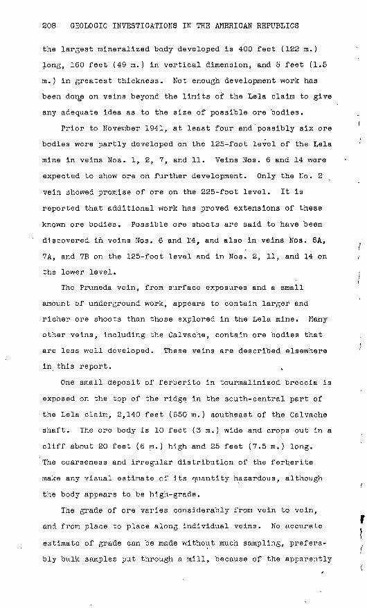
any adequate idea as to the size of possible ore bodies.
Prior to November 1941, at least four and possibly six ore
bodies were partly developed on the 125-foot level of the Lela
mine in veins Nos. 1, 2, 7, and 11. Veins Nos. 6 and 14 were
expected to show ore on further development. Only the No. 2
vein showed promise of ore on the 225-foot level. It is
reported that additional work has proved extensions of these
known ore bodies. Possible ore shoots are said to have been
discovered in veins Nos. 6 and 14, and also in veins Noa. 6A,
7A, and 7B on the 125-foot level and in Nos. 2, 11, and 14 on
the lower level.
The Pruneda vein, from surface exposures and a small
amount of underground work, appears to contain larger and
richer ore shoots than those explored in the Lela mine. Many
other veins, including the Calvache, contain ore bodies that
are less well developed. These veins are described elsewhere
in this report.
One small deposit of ferberite in tourmalinized breccia is
exposed on the top of the ridge in the south-central part of
the Lela claim, 2,140 feet (650 m.) southeast of the Calvache
shaft. The ore body is 10 feet (3 m.) wide and crops out in a
cliff about 20 feet (6 m.) high and 25 feet (7.5 m.) long.
The coarseness and irregular distribution of the ferberite
make any visual estimate of its quantity hazardous, although
the body appears to be high-grade.
The grade of ore varies considerably from vein to vein,
and from place to place along individual veins. No accurate
estimate of grade can be made without much sampling, prefera
bly bulk samples put through a mill, because of the apparently

TUNGSTEN DEPOSITS, ISLA DE PINOS, CUBA 209
spotty nature of the ore. It is hoped that heads containing
at least 1 percent WOg can be maintained.
The grade of the possible placer deposits is unknown, but
it is believed that much of the alluvial material in the dis
trict is worth testing. Small amounts of residual debris near
some of the vein outcrop might be expected to produce ferber-
ite.
Reserves
Not enough development work had been done at the time the
writers made their examination (1941) to permit satisfactory
estimation of potential tonnage and grade. At that time the
probable reserve of tungsten ore was estimated as about 55,000
tons containing approximately 750 tons of WOg. These figures
were based on visual estimates of grade plus a very few
assays, made available by W. M-. Archibald, and calc\ilations
from the grade of the few tons of ore mined and milled in
1939. Additional development work at the Lela mine is
reported to have disclosed ore in at least seven veins, most
of which do not appear on the surface above the workings. The
bodies observed have been extended by drifts, and ore has been
blocked out by raising. From these reports it appears likely
that the tonnage of probable ore is greater than estimated,
and that with continued development even larger reserves will
be proved.
The tonnage of possible ore present in the district is
fairly large, for, in addition to the 37 veins described in3
this report, there are other veins in which further under
ground exploration might be expected to reveal ore bodies.
Past experience shows that in this district even the smallest
of veins may widen to commercial size along either its strike
or dip.
210 GEOLOGIC INVESTIGATIONS IN THE AMERICAN REPUBLICS
The placer deposits on the Lela property might yield a
fairly large quantity of ferberite concentrates. There is
nearly 400,000 square yards of surface underlain by alluvium
that might possibly yield alluvial tungsten.
MINING AND PROSPECTING
The Lela claim is by far the most thoroughly prospected
portion of the Siguanea district and includes the only active
mine. Development work on the .other claims of the district
has been limited to shallow, unsystematic surface trenching.
Lela claim
The main workings on the Lela claim are the Lela mine and
Pruneda shaft. Two other prospect shafts, three adits, and a
number of pits and trenches prospect other parts of the prop
erty.
Lela mine.--The Lela mine (pi. 40) consists of a 240-foot
(73 m.) three-compartment shaft, from which lateral workings
extend oh the 125- and 225-foot levels. At the time of the
writers' examination, in November 1941, the workings included
995 feet (303 m.) of crosscuts and 1,920 feet (505 m.) of
drifts on the 125-foot v level; 550 feet (168 m.) of crosscuts
and 25 feet (7.5 m.) of drift on the 225-foot level; and three
raises, totaling 330 feet (100 m.) between the 125-foot level
and the surface. Additional development work done since that
time includes 415 feet (127 m.) of crosscuts and 1,050 feet
(320 m.) of drifts on the 125-foot.level, and three raises
from that level to the surface; on the 225-foot level, 60 feet
(18 m.) of crosscuts, 175 feet (53 m.) of drifts, and two
raises to the 125-foot level have been made.
Two small stopes were made in 1939 In the No. 2 drift N.
and the No. 1 drift S., from which about 100 tons of rock was
taken. The stope on the No. 2 vein is 15 to 18 feet (4.5 to

TUNGSTEN DEPOSITS, ISLA DE PINOS, CUBA 211
5.5 m.) high, about 80 feet (24 m.) long, 'and 6 to 8 feet (1.8
to 2.4 m.) wide; that on the No. 1 vein is 40 feet (12 m.)
long, 6 to 8 feet high, and 6 to 8 feet wide. It is said that
chutes have been prepared for stoping operations in the No. 1
drift N., No. 2 drift N., No. 6 drift S., No. 7 drift N. and
S., No. 11 drift'N. and S., and No. 14 drift S.
The country rocks are strongly jointed and sheeted mica
schist, quartz-mica schist, and quartzite, intruded by dikes
of feldspar-quartz porphyry. The rocks are thoroughly weath
ered on the 125-foot level, but are fresh on the lower level
except for minor weathered zones aloftg fractures and veins.
The schists and quartzites in the upper levels, especially
near the veins, are so strongly jointed that the rock breaks
into small pieces, and in places the veins themselves are
similarly jointed. This condition will be a material handicap
in stoping.
The porphyry dikes, though somewhat irregular, have a more
easterly trend than the veins. A vein, after paralleling the
dikes for a short distance, may pass through the porphyry,
where it breaks down into thin stringers and ill-defined
masses of tourmalinized rock, then resumes its usual character
on re-entering the schist. The porphyries act as channelways
for considerable quantities of water. One rhyolite porphyry
dike, 3 to 4 feet (.0.9 to 1.2 m.) wide, crosses the veins
exposed in the No. 1, No. 6, No. 7, and No. 11 drifts with a
straight course of N. 55° W. This dike was also identified in
the lower level.
Six veins containing ore bodies were observed on the 125-
foot level and two on the 225-foot level. Development work in'
the No. 3 crosscut W., completed after the examination, found
either extensions of these or three entirely new veins. A 5-
foot (1.5 m.) vein was also reported in the No. 9 crosscut E.
The No. 4 crosscut W. crosses four other veins, 6 to 12 inches
212 GEOLOGIC INVESTIGATIONS IN THE AMERICAN REPUBLICS
(15 to 30 cm.) thick, which might be expected to become
stronger along the strike or dip. In addition to all these,
more than 38 veins 1 to 6 inches (2.5 to 15 cm.) thick are
crossed by the workings. Only the important veins need be
described individually.
The No. 1 vein (pis. 34, 39, and 40) can be traced for 420
feet (128 m.) on the surface, for 230 feet (70 m.) on the No.
1 adit level, and for 400 feet (122 m.) in the No. 1 drift S.
It is followed by the No. 1-A raise, and it is also inter
sected by the shaft at 96 feet (29 m.), but it feathers out
northward and appears in the No. 3 crosscut as a group of nar
row stringers. This vein was not recognized on the 225-foot
level.
On the surface, where the vein is locally as much as 5
feet (1.5 m.) thick, it is composed of silicified and tourma-
linized schist with a center of massive to crystalline quartz.
North of the No. 1-A raise it consists of silicified breccia 3
to 4 feet (0.9 to 1.2 m.) thick. It appears to intersect the
vein designated as No. 1-A near the water tank. The No. 1-A
vein, though poorly exposed, probably persists under the flat
northeast of the old Vanadium Corporation trenches to the
silicified and brecciated vein zone in the Mercedes claim. To
the south, scattered outcrops of vein quartz, tourmalin!zed
and silicified porphyry, and schist suggest that this vein
extends across the hills. It may represent one of the main
channelways followed by the ore solution. It also marks the
western edge of the ir^on-stained brecciated zone. Outcrops
suggest that there are other subsidiary veins.
On the adit level the No. 1 vein is composed of vuggy
quartz, which is 40 inches (1 m.) thick in places, and of
brecciated quartz in a tourmaline matrix. Perberite was
observed in both the quartzose and the tourmaline-rich

^ TUNGSTEN DEPOSITS, ISLA DE FINDS, CUBA 213
> " " ' ' ^^ Imaterial. Similar material is 'found on the 125-foot level,
but here the vein rarely exceeds 30 inches (76 cm.) in thick
ness.
In the Ho. 1 adit (pi. 39)>this vein strikes N. 5° E.
except at the north end, where lit strikes N. 25° E., and dips
55° to 60° NW. At the south end of the adit it splits; the
main vein south of the fork strikes N. 15° W. and dips 55° SW.
and the lesser branch strikes N. 3^5° E. and dips 75° SE. On
the 125-foot level the vein strikes N. 10° E.. and dips 55° to
60° NW. in the northern end of the'No. 1 drift S., and strikes
N. 20° E. arid dips 60° to 90° NW. in. the southern part of the
same drift.
Where it is crossed by prominent sheeting zones, the vein
is brecciated and consists largely of tourmaline. In these
places the rocks adjacent to the vein are impregnated with
quartz and tourmaline. The less brecciated ve4^u»frt^eT? is
mainly quartz, but ferberite and a little sulfide are visible
in most of the exposed portion. The vein is in part weath
ered, and near the No. 4 crosscut W. it carries large quanti
ties of iron oxide, in which wires of native copper occur. On
the 125-foot level the ore body is at least 250 feet (76 m.)
long and 12 to 48 inches (30 to 122 cm.) thick, averaging 24
inches (60 cm.).
The vein called the No. 2 on the 125-foot level cannot be
definitely identified on the surface, and the vein thus desig
nated in plate 34 may be the subsidiary vein No. 2-A, which is
also exposed on the 125-foot level. It can be traced on the
surface for 160 feet (50 m.) and contains 6 to 10 inches (15
to 25 cm.) of quartz with ferberite.
On the 125-foot level (pi. 40) the No. 2 vein is exposed
for 445 feet (135 m. ) in the No. 2 drifts N. and S-. and is
also exposed in the No. 2-A raise. The ore body is about 300

214 GEOLOGIC INVESTIGATIONS lit THE AMERICAN REPUBLICS
f - )' feet (91 m.) long. The middle,150 feet (46 m.^-of "the ore
body is mainly quartz and 30 to 36 inches (7\6 to 91 cm. )
thick; the ends are largely brecciated quartz and tourmaline.
The vein pinches out in both directions and is represented in
the No. 4 crosscut W. by 1- to /2- inch (2.5. to 5 cm.) string- -
ers. The vein strikes about N, 20° E. and dips 50° to 60°
NW., though there are local dips as high as 70°. Perberite isi
present throughout the length of therein, but the deposit
will probably suffer some dilution in stoping because of' the
highly fractured nature of the wall rock. A composite sample
of ore mined from this vein in 1939 is said to have assayed
slightly over 1 percent of WOg, and calculations of concen
trates recovered and los^sejs in milling checked this, figure.
In. the No. 201 crosscut (pi. 40) this vein, where it was
cut 142 feet (43 m.} west of the shaft, was 12 inches (30'cm.)
wide and ' Qoztt-ain&d. coarse ferberite, sulfides, quartz, andx'
tourmaline. It is reported that on .drifting 35 feet .(10.6 m. )
north the vein was found to widen to 5 feet (1.5 m.), but it
narrowed at 100 feet (30 m.), where a raise was started. The
wide part of the vein and the drift south are reported to be
in ore.
The" No. 6 vein, 150 feet (45 m.) west of the No. 1 vein,
is poorly exposed on the surface, but it can be seen to be a
quartz vein, containing ferberite where its walls are schist,
and a tourmalinized zone where it crosses feldspar-quartz por
phyry. On the 125-foot level (pi. 40) it strikes about N. 10°
E. and dips 80° NW., and is exposed for about 250 feet (76 m.)i
as an 8- to 15-inch (20 to 38 cm.), highly fractured and
sheared quartz vein containing sulfides and ferberite. Recent
development is reported to have disclosed a mineralized shoot
150 feet (45 m.) long. This vein may intersect the No. 1 vein
down dip and along the strike to the south; to the north it
may connect down dip with the No. 2 vein. The No. 2-A vein is

TUNGSTEN DEPOSITS, ISLA DE PINOS, CUBA 215
probably an offshoot of the No. 6. Although narrow, it con
tains considerable ferberite.
In the No. 3 crosscut W., a vein along the west aide of a
porphyry dike, designated as the No. 6-A vein, is reported to
contain 10 inches (25 cm.) of quartz with WOg. This is said
to die out southward against porphyry and to widen northward.
It strikes about N. 10°-15° E. and dips 80° NW., probably con
necting with vein No. 2 at depth.
The No. 7 vein is exposed on the surface at the east end
of the long east-west trench 450 feet (137 m.) southwest of
the Lela shaft. There are two small offshoots on the hanging-
wall side, 20 feet (6 m.) north and 100 feet (30 m.) south of
the trench, which may be traced toward the No. 11 vein for 50
feet (15 m.). The main No. 7 vein can be ̂ traced'140 feet (42
m.) northward to its intersection with porphyry, where it is
covered with alluvium, and 100 feet (55 m.) southward to the
No. 7-A raise, where it is almost on the porphyry contact.
South of the raise it cannot be definitely traced,' but it
probably is represented by vein outcrops 100 feet south, which
intersect the No. 11 vein near the top of the hill.
Underground the No. 7 vein (pi. 40) is exposed for approx
imately 500. feet (152 m.) in the No» 7 drift, but possible ore
is limited to 350 feet (106 m.). There are two separate min
eralized bodies, one of which begins 80 feet (25 m.) north of
the No. 4 cro.sscut W. and extends 70 feet (21 m. ) along the
No. 7 drift S. A body of schist 40 feet (12 m.) long and up
to 5 feet (1.5 m.) wide is enclosed in ore 30 to 36 inches (75
to 90 cm.) thick. South of this schist the vein is 20 to 36
inches (50 to 90 cm.) thick; just to the north it is 48 inches
(120 cm.) thick, but it thins rapidly northward and splits
north of the rhyolite dike. South of the No. 4 crosscut W.
the vein dips 70° NW., but to the north it is nearly vertical.

216 GEOLOGIC INVESTIGATIONS IN THE AMERICAN REPUBLICS
At the north end of the drift the vein is represented by
stringers that dip 70° to 75° SE.
The second mineralized body starts 40 feet (12 m.) south
of the one described above and is at least 200 feet (60 m.)
long. It has been followed to the surface by the No. 7-A
raise. In the drift the vein is 12 to 36 inches (30 to 90
cm.) wide, averaging 18 inches (45 cm.), but in the raise it
is reported to average 24 inches (60 cm.) and to be, in
places, as much as 5 fe*et (1.5 m.) thick. The ore shoot dips
70° to 75° NW., and it may be connected, above the 125-foot
level, with the other ore shoot, as the vein between appears
to have been thinned by postmineral faulting. Iron sulfides
are abundant on these faults.
In the No. 9 crosscut E. there is said to be a 5-foot (1.5
m.) vein that may be an offshoot of the No. 7. Two other
promising veins, No. 7-A and No. 7-B, are said to be exposed
in the No. 3 crosscut W. The No. 7-A vein is 1 to 3 feet (0.3
to 1m.) thick and has been exposed for 115 feet (35 m.) in
the drift. The No; 7-B is 10 inches (25 cm.) wide and has
been drifted on for 35 feet (10 m.). Both dip 80° NW. and
both contain ferberite. These are represented on the 225-foot
level by narrow stringers.
The map suggests that the No. 7 vein may be expected to
join the No. 11 vein about 350 feet (107 m.) south of the
present workings, almost directly beneath the intersection of
these ve^ins on the surface. This vein is similar in'mineral
composition to the others in the Lela mine, but in its wider
parts it contains a larger proportion of silicified and tour-
malinized wall rock. Assays are said to show that this min
eralized wall rock contains as high a percentage of tungsten
as the parts of the veins that appear to "be fracture fillings.
The postmineral fault fissures are occupied by pyrite veins,
but these do not contain ferberite.

TUNGSTEN DEPOSITS, ISLA £>E PINOS, CUBA 217
The No. 11 vein, 120 feet (36 n.) west of the No. 7, can
be traced almost continuously on the surface for at least
1,400 (425 m.) and possibly 1,700 feet (520 m.). Through a
vertical range of 180 feet. (55 m.) the vein, which contains as
much as 24 inches (60 cm.) of quartz, is in the middle of a
tourmalinized, silicified, and brecciated zone 15 feet (4,5
m.) in maximum width. In places the wall rocks have been
altered to tourmaline schist or^gneiss. Ferberite was
observed only on the north side of the hill; none was seen in
the veins, east of the No. 11 vein and roughly parallel to it,
that are well exposed on the south side of the hill.
The No. 11 vein has been explored by drifting on both the
125- and 225-foot levels. Throughout most of the No. 11 drift
the vein consists of a single quartz-tourmaline vein whose
wall rocks are more or less replaced, but in the northern part
of the drift the vein splits or "horsetails out" into a number
of thin stringers, many of them rich in ferberite. Between
these stringers the schist is strongly silicified. The thick
ness of the vein ranges from 6 to 60 inches (15 to 150 cm.),
averaging 18 inches (45 cm.) between the face and a point 80
feet (24 m.) north of the No. 4 crosscut W. North of this
point one to four stringers, up to1 6 inches (15 cm.) thick,
occur in a silicified zone 6 to 12 feet (1.8 to 3.6 m.) wide.
Small parts of this section may be rich enough to stope, for
some of these narrow veins contain as much as 50 percent fer
berite. A snail mass of schist included in the vein just
north of the No. 4 crosscut W. splits the 60-inch (1.5 m.)
vein into two parts. South of the schist the thickness of the
vein is f rorn' 12 to 30 inches (30 to 76 cm.) except for a 25-
foot (7.5 m.) section that is thinned to 6 or 8 inches (15 or
20 cm.) by faulting. The vein dips 70° to 80° NW. except on
the footwall split north of the schist inclusion, where the
dip is 80° to 90° NW.

218 GEOLOGIC INVESTIGATIONS IN THE AMERICAN REPUBLICS
The No. 11-A raise, 200 feet (61 m.) south of the No. 4
crosscut W., followed the vein to the surface. Here the vein
averaged 18 inches (45 cm.) in thickness but in places it was
4 to 5 feet (1.2 to 1.5 m. ) thick. It i's said that a 35-foot
(10.6 m.) section just below the surface contained high-grade
ferberite, although the average ore in the vein was not high-
grade .
On the 225-foot level the^No. 11 vein is exposed in the
No. 202 drift S. In the No. 201 crosscut W. it is 2 to 5
inches (5 to 13 cm.) thick and contains ferberite, in part
altered to scheelite. Here it strikes N. 35° E. and dips 55°
SE., but in the drift to the south it becomes stronger and has
the same attitude as on the 125-foot level. A raise on this
vein shows ore.
The No. 14 vein has been traced continuously on the sur
face for 1,000 feet (305 m.) south of the No. 14-A raise. It
does not crop out strongly for the first 300 feet (91 m.),
but it is prominent farther south, where it consists of 8 to
24 inches (20 to 60 cm.) of quartz in an altered zone up to 5
feet (1.5 m.) thick. The No. 14 vein has been exposed for 350
feet (107 m.) on the 125-foot level and is said to be exposed
in the No. 201 crosscut W. on the 225-foot level. In the No.
4 crosscut W. it is a zone of dark, dense, tourmalinlzed and
silicified schist 4 feet (1.2 m.) wide. South of the No. 14-A
raise the vein averages 24 inches (60 cm.) thick and contains
from 10 to 18 inches (25 to 45 cm.) of quartz. One ore shoot,
165 feet (50 m.) south of the crosscut, continues to the south
for 70 feet (21 m.). Specimens reported to come from this ore
shoot indicate that the 10-irich (25 cm.) quartz center may
contain considerable WOg. There is some fine-grained ferber
ite in the tourmalinized walls. On the 225-foot level, this
vein is up to 4 feet (1.2 m.) wide and contains very fine
grained ferberite and considerable iron and copper sulfide.

TUNGSTEN DEPOSITS, ISLA DE PINOS, CUBA . 219
The No. 14-A vein, 40 feet (12 m.) west of the No. 14, is 4
feet (1.2 m.) thick, and has good possibilities of ore.
On the surface, about 90 feet (27 m.) east of the No. 14-A
raise, a 12-inch (30 cm.) quartz vein, the No. 12, strikes N.
10° E. and dips 60° to 65° NW. toward the No. 14 vein. Fer-
berite is present in the float of the No. 12 vein for a dis
tance of 240 feet (73 m.), and this vein would seem to be one
of the more promising from its surface exposures, although it
is not of commercial size on the 125-foot level.
The No. 4 shaft,' 1,080 feet (330 m.) N. 6° W. of the Lela
shaft, is probably on either the No. 15 or a subsidiary vein
of the same group. This is a 10- by 6-foot (3 by 1.8 m.)
prospect shaft about 20 feet (6 m.) deep, inclined 70° to the
southeast. It was sunk on a mineralized zone 6 feet (1.8 m.)
wide which strikes N. 38° E. The hanging wall of the vein is
porphyry and the footwall gray quartz schist. Ferberite was
observed at the point where the shaft started but did not con
tinue with depth.
The No. 15 vein crops out 300 feet (91 m.) west of the No.
14-A raise as a well-defined rib of ferberite-bearing quartz
and silicified schist. It strikes N. 30° E. and dips 75° SE.
Where cut by the No. 4 crosscut W. on the 125-foot level, it
is 10 to 12 feet (3 to 3.6 m.) wide but is split by rhyolite
porphyry. Its western part contains some ferberite. This
vein appears to be in a major fracture, from which at least
four strong ferberite-bearing veins split off, as indicated in
structure section A-A' in plate 34. The No. 15 vein probably
intersects the No. 14 vein about 500 feet (152 m.) below the
surface. The No. 1G and No. 15 veins may intersect south of
the exposures of the No. 15 vein.
The No. 16 vein is exposed for 400 feet (122 m.) about 80
feet (24 m.) west of vein No. 15, along the north side of the
hill. The northern part of the outcrop shows a strike of

220 GEOLOGIC INVESTIGATIONS IN THE AMERICAN REPUBLICS '
N. 18° E.; in the southern part the strike is N. 23° E. and
the dip 80° SE. About 150 feet (45 m.) of the vein is in
schist and the remainder in porphyry. This vein has not been
cut by underground workings.
Small exposures and float on the trend of this vein, 360
feet (110 m.) east of the Pruneda shaft, contain considerable
ferberite.
Pruneda shaft. The Pruneda two-compartment shaft, 1,390
feet (423 m.) northwest of the Lela shaft, prospects the
Pruneda or No. 18 vein. It was about 160 feet (50 m.) deep at
the time of examination. Two short crosscuts extend west from
it to the vein on the 60- and 100-foot levels. It is planned
to continue the shaft to 200 feet (60 m.) and to connect it by
means of lateral workings with the No. 201 crosscut W. of the
Lela mine, and also to prospect the ferberite-bearing vein
that crops out 200 feet west of the Pruneda vein. The Pruneda
vein has been stripped for 130 feet (40 m.) south and 60 feet
(18 m.) north of the shaft, and also along a stretch 260 to
440 feet (80 to 135 m.) north of the shaft. Cross trenches
have been made 190, 280, 330, 420, 500, 650, and 780 feet (58,
85, 100, 128, 152, 198, and 238 m.) south of the shaft.
The Pruneda vein (pi. 34) is the most promising member of
the largest vein system in the area. The system includes
veins No. 18 (Pruneda), 18-A, 19, 19-A, 19-B, 19-C, and 20, as
well as unnumbered vein outcrops northeast of the shaft, and
it can be traced intermittently for about 4,400 feet (1,340
m.). The Pruneda vein is traceable for 1,500 feet (457 m.)
between its outcrop above the Pruneda adit and the place where
it feathers out northeast of the shaft. The ore bodies "are
probably a series of closely spaced overlapping lenses rather
than a single continuous vein filling. They occur in a zone 6
to 8 feet (1.8 to-2.4 m. )

GEOLOGICAL SURVEY BULLETIN 935 PLATE 89
ALTITUDE OF PORTAL -,J, // ? er ALTUNA DE LA BOCA '*' '' °°
LELA SHAFT TIRO LELA
CO
i-h
If?erf-
IUJ [ 2LU
Quartz pegmatite lens Lentes de pegmatita. cuarcifera
50 1 i i
5 0i i i i i i
5i
0 i
i i
Feet 50 Pies
_,- Meters , i Metros
EXPLANATION
Biotite-quartz schist
Wolframite -quartz veins (Stippling indicates brec- ciatea and tourmolinized part)
Fissure, showing dip
Strike and dip of foliation and bedd ing
Shaft
Winze
Raise
B
EXPLICACION
Esquistos de cuarzo y biotita
Vet as de cuarzo y wolf- f ram it a. (Las pore i ones punteadas indican zonas de brecha y turmalina)
Fractura, indicando su buzam iento
Rum bo y buzamiento de foliacio'n y estratificacion
Tiro
Pozo
Contra pozo
GEOLOGIC MAP OF THE NO. 1 ADIT, LELA CLAIM ISLA DE PINOS, CUBA
PLANO GEOLOGICO DEL SOCAVON NO. 1, CONCESION LELA, ISLA DE PINOS, CUBA

TUNGSTEN DEPOSITS, ISLA DE FINDS, CUBA 221
The most northerly trench on the vein exposes 180 feet (55
m.) of vein material from 2 to 4 feet (0.6 to 1.2 m.) thick.
At the southern end of this trench a vertical quarts lens, 6
to 12 inches (15 to 30 cm.) wide and 30 feet (9 m.) long,
occupies the center of a 2-foot (0.6 m.). zone of silicified
and tourmalinized schist. To the north, the vein is 4 feet
(1.2 in.) wide and composed of black tourmaline rock that
strikes N. 13°-30° E. and dips 75° NW. Ferberite was not
observed in place but was found on the dumps. Immediately
north of the shaft a trench exposes two lenses of vein mate
rial separated by 3 feet (1 m.) of schist. The western lens,
which strikes N. 18° E., consists of 12 to 18 inches (30 to 45
cm.) of quartz enclosing a little tourmaline. The other,
which crops out only in the northern end of the trench, is 12
inches thick, consists mainly of quartz, and dips 75° 1IW. The
long trench south of the shaft was filled with water and caved
at the time of examination, but the main vein there is said to
have been 5 to 6 feet (1.5 to 1.8 m.) thick. Near the shaft
the vein strikes N. 27° E. and is vertical; in the southeast
corner of the trench it strikes N. .23° E. Apparently the vein
was irregular and had numerous stringers projecting from its
eastern wall. In the crosscut on the 60-foot level the vein
is about 5 feet (1.5 m.) wide and is mainly tourmaline and
silicified rock, but on the 100-foot level, where the vein is
5 feet thick, it is largely quartz, with some tourmaline rock
at the edges. At a point 10 feet (3 m.) west of the shaft,
where the vein'strikes N. 18° E. and dips 85° NW., the foot-
wall is cut by a fracture striking N. 23° E. and dipping 65°
NW., and a 12-inch rhyolite porphyry dike, dipping 70° NW.,
splits the vein along the middle. Ferberite is present
throughout the mineralized zone in these underground expo
sures; large masses of it fill cavities lined with euhedral

222 GEOLOGIC INVESTIGATIONS IN THE AMERICAN REPUBLICS
quartz, and small grains are disseminated in the massive
quartz and in the tourmalinized part of the vein. Arsenopy-
rite fills cavities and is enclosed in the quartz. Seams of
pyrite, chalcopyrite, arid greenish or brown tourmaline cut the
other minerals.
Between the Pruneda adit and the shaft the vein is exposed
in seven cross trenches, but these were filled with water and
slumped so that no detailed examination of them was possible.
There are many exposures between the trenches, but they are
all small. A composite sample from vein material in the
trenches is reported to have 1 assayed about 2 percent of WOg.
The first trench, 190 feet (58 m.) south of the shaft, shows
vuggy quartz and ferberite, which may be followed by float and
small outcrops S. 8° W. to the second and third trenches,
where 2 feet (6.6 m.) of crystalline quartz, tourmaline, and
ferberite is exposed. In the fourth trench the vein is split
by 2 feet of red clay, probably representing a weathered rhyo-0
lite porphyry dike that strikes N. 24° E. and dips 80° NW.
The vein material east of the red clay is 2^- feet (0.7 m.)
thick and that west of it 1 foot (0.3 m.) thick. In the east
ern part there is 12 inches (30 cm.) of massive quartz,
enclosed in dark green to brown tourmaline containing scat
tered euhedral quartz crystals. Ferberite is present in both
the'quartz and tourmaline. South of the trench the vein is
mostly tourmaline, with 25 to 30 percent of scattered euhedral
quartz. It can be traced to the fifth trench, where it is
also split by red clay; here the eastern part is 12 inches
thick and the western part 1 to 2 feet (0.3 to 0.6 rn. ) thick.
On the south side of the alluvium-filled gulch a trench
exits three veins. Here again the Pruneda vein is divided into
two parts by 10 to 36 inches (45 to 90 cm.) of red clay. The
western part, 2 feet (0.6 m.) thick," is separated by 2^ feet
(0.7 m.) of schist from a 3-jg-foot (1 in.) vein, striking

TUNGSTEN DEPOSITS, ISLA DE PINOS, CUBA 223
N. 13° E., which has been designated as No. 18-A. Another
vein, 6 inches (15 cm.) thick, striking N. 28° E., and dipping
75° SE., is 6 feet (1.8 m.) west of the No. 18-A. Other
trenches, 120 feet (36.4 m.) to the south, started just west ;
of the Pruneda vein and cut two 3- to 4-inch (7.G to 10 cm.)
veins, separated by 6 inches of schist, that strike N. 23° E.
and dip 70° SE. The Pruneda vein continues as a 2- to 4-foot
(0.6 to 1.2 m. ) sili'cified and tourmalinized zone from east of
these pits to the Pruneda adit and vein No. 19.
Pruneda adit. The Pruneda adit (pi. 41), 1,100 feet (335
m.) south of the Pruneda shaft, started on the Pruneda vein,
which thins southward to a narrow stringer 125 feet (38 m.) in
from the portal. About 600 feet (100 m.) of crosscuts and
drifts explore three weak veins in feldspar-quartz porphyry
and schist. A raise to the surface followed the most easterly
of these veins, but the vein is said to have been lost where
it passed out of the porphyry. On the adit level, 10 feet (3
m.) east of the Pruneda vein, this vein is 15 inches (38 cm.)
wide, strikes about N. 30° E., and dips 75° SE. In places it
attains a thickness of 30 inches (75 en.), made up largely of
quartz, but it thins to a narrow stringer outside the por
phyry. Near the southern end of this vein and 25 feet (7.5
m..) east of it, a crosscut exposes a 4-foot (1.2 m. ) zone of
tourmaline veinlets in porphyry. This zone also dies out to
the south on entering schist, although thin ferberite-bearing
veins are exposed near the face of the drift.
The veins exposed in the adit are part of the Pruneda sys
tem. They underlie the No. 19 vein, which on the surface may
be followed intermittently for about 1,200 feet (365 m.)
southward from a point 100 feet (30 m.) southwest of the
Pruneda adit. The No. 19 vein is represented in the large
trench at the top of the hill by very thin veins of quartz and
tourmaline with ferberite in a mineralized zone 5 feet (1.5 m'. )

224 GEOLOGIC INVESTIGATIONS IN THE AMERICAN REPUBLICS
wide. North of the trench this zone consists primarily of
silicified a'nd tourmalinized schist, in which no ferberite was
observed. At the trench another vein, No. 19-B, splits off in
a northeasterly direction, and in outcrops 100 feet (30 m.) to
the northeast it contains ferberite. The No. 19 vein crops
out strongly for 175 feet (53 m.) south of the trench as a 2-
foot quartz-tourmaline vein. Float may be.traced for 200 feet
(60 m.) to the southwest, down a spur along which there are
outcrops of massive quartz. Intermittent exposures extend
S. 35° W. to a strong outcrop 125 feet.(38 m.) long, in por
phyry. South of this outcrop the vein is obscured by debris,
but it may steepen in dip and extend to the tourmalinized
breccia in the bottom of the gully. The breccia merges with a
strong 7-inch (18 cm.) quartz vein, which follows the north
east contact of a porphyry dike for 150 feet (45 m.). No fer
berite was observed in the No. 19 vein except above 250 feet
(75 m.) in altitude, though it occurs in the two subsidiary
veins, Nos. 19-A and 19-B.
At the top of the hill another vein, No. 17, 25 feet (7.5
m.) east of the No. 19 vein, is exposed in two cross trenches.
In the southern trench, 4 feet (1.2 m.) of fine-grained gray
breccia is cut by four fluted and slickenslded fault fissures
striking N. 23° E. and dipping 60° SE. The quartz-mica schist
strikes N. 80° E. and dips 45° SE. on the footwall and strikes
N. 50° E. and dips 45° SE. on the hanging wall. A 3-inch (7.6
cm.) quartz vein that strikes N. 25° E. and dips 75° NW., cuts
the schists 2 feet (0.6 m.) below the fault zone, and there is
an 8-inch (20 cm.) vein, which strikes N. 30° E. and dips 90°,
4 feet (1.2 m.) east of the hanging wall. The fault probably
follows the main vein, and, as the tourmaline is slickensided,
the faulting must have occurred later than the mineralization.
In a trench 85 feet (26 m.) to the north, a 2-foot gray brec
cia zone strikes N. 31° E. and dips 65° SE. On the footwall

TUNGSTEN DEPOSITS, ISLA DE PINOS, CUBA 225
there is in places as much as 5 feet (1.5 m.) of silicified
schist with veins of tourmaline and quartz that strike N. 33°
E. and dip 75° SE.; and on the hanging wall there is 2 feet
(0.6 m.) of vein material. Large blocks of ferberite-bearing
quartz on the dump at the eastern end of the trench suggest
that a vuggy quartz vein 1 to 2 feet (0.3 to 0.6 m.) wide and
rich in ferberite was cut. North of this trench the vein
zone, 6 to 8 feet (1.8 to 2.4 m.) wide splits near a dike of
porphyry. The No. 17 vein trends.N. 45° E., and the No. 17-A
may be seen to trend N. 18° E. for 50 feet (15 m.) to a point
where it dies out or is covered by debris.
Calvache shaft. The Calvache shaft, 3,000 feet (915 m.)
west of the Lela shaft, started by the Molybdenum Corporation
of America in 1939, is reported to have reached a depth of 60
feet (18 m.) and to have cut the Calvache, or No. 28, vein at
50 feet (15 m.). Surface exposures of this vein are pros
pected by trenches 120 feet (36 m.) north and also 125 feet
(38 m.) and 500 feet (152 m.) south of the shaft. Eight other
trenches have been made in the low area west of the settlement
of Siguanea on what appears to be the Calvache vein or other
members of the same vein system.
At the shaft the Calvache vein strikes- N. 23° E. and dips
40° to 70° SE. Intermittent outcrops suggest that this vein
may extend as much as 700 feet (213 -m.) south of the shaft as
a brecciated, silicified, tounnalinized zone with a discontin
uous center of quartz up to 12 inches (30 cm.) thick. Ferber
ite is present as coarse grains in vuggy quartz and occurs
also in the'tourmaline rock. A number of poorly exposed veins
farther east appear to be branch veins that trend northward
towards the Calvache vein. Of these, vein No. 28-A appears to
be the only one of possible economic value. This vein strikes
N. 13° E. and dips 70° SE. It is exposed in two outcrops,
each about 100 feet (30 m.) long, which are 120 feet (37 m.)

226 GEOLOGIC INVESTIGATIONS IN THE AMERICAN REPUBLICS
apart and connected by abundant vein float. The vein consists
predominantly of silicified and tourmalinized rock and has a
quartz-ferberite center up to 3 inches (7.6 cm.) thick.
In poor exposures extending 400 feet (120 m.) north of the
shaft, the Calvache is a vuggy quartz vein 6 to 12 inches (15
to 30 cm.) wide that carries ferberite. Other parts of the
vein, up to 3 feet (1 m.) thick, consist of tourmalinized and
silicified rock, which is in part brecciated. The northern
continuation of this vein is indefinite, but a number of iso
lated outcrops and ferberite-bearing vein float may be fol
lowed northeastward to a strong vein at the northwest end of
the hills. Other scattered outcrops of vein material suggest
that the main vein continues north to the northern part of the
Lela and the southern part of the Genaro claim, passing
through the trenches 1,600 and 1,900 feet (490 and 580 m.) N.
23° E. of the shaft.
No. 2 adit.--The No. 2 adit (pi. 42), 415 feet (125 m.)
northeast of the Calvache shaft, was started on the best sur
face showing of ore that had been found up to 1939, when the
Pan-American Tungsten Corporation acquired the property. A
ton or more of high-grade ore is said to have been taken out
of the open pit. It carne from an ore shoot about 80 feet (24
m.) long, which is said to have ended abruptly about 30 feet
(9 m.) south of'the portal. The shoot was in feldspar-quartz
porphyry; it is now covered with debris.
Above the portal of the adit, stringers of tourmaline and
quartz, which strike N. 30° E. and dip 50° SE., are exposed in
the porphyry for 30 feet (9 m.), and a silicified zone contin
ues for another'70 feet (21 m.) to a place where well-defined
quartz veins are exposed. In the trenches at the top^of the
ridge small lenses of ferberite-bearing vein material are
truncated by rhyolite porphyry and faults. The mineralized
zone is not continuous down the north slope of the ridge, but

TUNGSTEN DEPOSITS, ISLA DE PINOS, CUBA 227
small isolated lenses of vein matter are exposed in the
trenches.
The adit, which is 235 feet (72 m.) long, was made in an
attempt to find the continuation of the .high-grade ore body
exposed in the open cut. A tourmaline vein dipping 30° SE.
was intersected 30 feet (9 n.) northeast of the portal, and ;
one small mass of high-grade ore was found. This vein is 12
to 15 inches (30 to 38 cm.) in width and has a 2-inch (5 cm.)
quartz center. It dies out to the north where the tunnel
turns eastward. Two other small veins and a rhyolite porphyry
dike were intersected by the tunnel. The easternmost vein was
cut by a fault, striking N. 15° W. and dipping 65° SW., along
which there is 12 inches of gouge.
Ho. 5 adit.--The No. 3 adit (pi. 42), 340 feet (104 m.)
southeast of the No. 2 adit, prospects the No. 26 vein, which
is reported to have contained considerable ferberite where
mined in the open cut. Specimens of coarse-grained ferberite
(see pi. 38) in quartz are found on the dumps, but the vein is
now covered with debris. The outer part of the adit follows a
fault that parallels the vein and is marked by gouge and con
torted schist. Fifty feet (15 m.) from the portal the vein
splits or is repeated by faulting, and the eastern segment,
which is followed by the adit, pinches out within a few feet.
The remainder of the adit is in schist cut by a few very thin
stringers of quartz.
On the surface the identity of the vein followed by the
adit is lost about 25 feet (7.5 m.) north of the portal in a
silicified and tourmalinized zone about 30 feet (9 m.) wide,
but float of coarse vein quartz with ferberite is abundant.
Another vein, the No. 26-A,' forms the western edge of this
zone. It has been traced S. 30° W. for 175 feet (53 m.).
Eight inches (20 cm.) of ferberite-bearing quartz is exposed

228 GEOLOGIC INVESTIGATIONS IN THE AMERICAN REPUBLICS
at the southern end of the outcrop; in some places this fer-
berite-bearing quartz is 12 inches (30 cm.) thick.
A weak vein, probably the southward extension of No. 26,
was traced for 135 feet (41 m.) S. 15° W. from the dump.
Another vein, No. 26-B, just west of the dump, trends S. 25°
W. for 140 feet (43 m.); and what is perhaps the same vein,
displaced 20 feet (6 m.) to the west, extends S. 28° E. for
165 feet (50 m.), then turns S. 5° VJ. and dies out in silici-
fied schist. The northern segment of the vein, part of which
is 2 feet (0.6 m.) thick, contains coarse ferberite in quartz.
A brecciated tourmalinized schist separates this from a part
of the vein in which tourmaline predominates over quartz. The
.southern segment, which is 2 feet (0.6 m.) thick where exposed
in a trench, strikes N. 20° E. and dips 45° SE. South of the
trench the vein outcrop shows irregular, discontinuous lenses
of quartz.
Trenches northeast of the No. 3 adit reveal four veins
containing coarse ferberite. One of the strongest veins is
Ho. 26-C, east of No. 26. Outcrops of this vein extend for
475 feet (145 m.) over the top of the hill, and the vein has
been traced by float and poor outcrops down the north side of
the hill. At some places on the south slope of the hill it is
as much as 5 feet (1.5 m.) thick. It is 2 feet (0.6 m.) wide
in the trench at the north end of its outcrop, and has 8
inches (20 cm.) of quartz in the middle. This vein consists
largely'Of silicified rock and quartz with little toxirmaline.
Coarse ferberite is most abundant in the southern part where
the vein is over 2 feet wide.
Between the No. 26-C and the No. 25 veins are several nar
row veins that do not contain visible ferberite. THe No. 25
vein is a series of discontinuous thin lenses of quartz and
tourmaline containing coarse ferberite. The lenses occur in a
zone 20 feet (6 m.) wide and 150 feet (45 m.) long. At the

GEOLOGICAL SURVEY BULLETIN 935 PLATE 41
EXPLANATION
Schist and quartzite
Feldspar- quartz porphyry
Quartz-tourmaline vein
Strike and dip of bedding and foliation
Strike and dip of sheeting
Strike of vertical sheeting
Strike and dip of contact
Strike of vertical contact
Winze
Open pit
50 Feet ______j Pies
80
-e-
70y
EXPLICACION
Equistos / cuarcita
Porfido de feldespato y cuarzo
Veto de cuarzo y fur ma lino
Rum bo y buzamiento de estratificacidn y fo/iacidn
Rumbo y buzamiento de sistema de fractures pa r ale las y contiguas
Rumbo de sistema vertical de fracturas parole las y contiguas
Rumbo / buzamiento del contacto
Rumbo del contacto vertical
Pozo
To jo a bier to
Meters Metros
GEOLOGIC MAP OF THE PRUNEDA ADIT, LELA CLAIM, ISLA DE PINOS, CUBA PLANO GEOLOGICO DEL SOCAVON PRUNEDA, CONCESION LELA,
ISLA DE PINOS, CUBA

GEOLOGICAL SURVEY BULLETIN 936 PLATE 4 2
Adit No.3 Socavon No.3
10I
100Pees
on MetersMetros
JO
EXPLANATION
Rhyolite porphyry
Quartz-tourmaline vein, showing dip
Feldspar-quartz porphyry
Quartz-mica schist and quartzite
Strike and, dip of bedding and foliation
Fault,showing dip
Strike and dip of sheeting
EXPLICACION
Porfido riolitico
Vet as de cuarzo y turmalina, indicando su buzamiento
Porfido de cuarzo y feldespato
Esquistos de cuarzo ym/ca,y cuarcita
Rumbo y buzamiento de estratificacidn y foliacio'n
Falla, indicando su buzamiento
Rumbo y buzamientode sisfema de fracturas paralelasy configuas
Adit No.2 Socavon No.2
GEOLOGIC MAP OF THE NO. 2 AND NO. 3 ADITS, LELA CLAIM,ISLA DE PINOS. CUBA
PLANO GEOLOGICO DE LOS SOCAVONES NO. 2, Y NO. 3, CONCESION LELA, ISLA DE PINOS, CUBA

TUNGSTEN DEPOSITS, ISLA DE PINOS, CUBA 229
south end of the trench the vein, which crops out for 30 feet
(9 m.) and is up to 1 foot (0.3 m.) thick, strikes N. 20° E.
and dips 50° SE. At the north end of the trench a segment of
this vein strikes N. 28° E. and dips 80° SE. Ferberite was
observed in both places.
The No. 24 vein, about 225 feet (68 m.) east of the No.
25, has been prospected near its north end by a cross trench.
Here the vein strikes N. 33° E. and dips 65° SE. It is pre
dominantly tourmaline but contains ferberite. About 75 feet
(23 n.) south of the trench the vein is apparently offset.10
feet (3 m.) to the west; beyond this offset its outcrop con
tinues for 320 feet (97 m.) farther southward. On the top of
the ridge and on the south slope the vein dips as steeply as
80° SE. Here it is as much as 5 feet (1.5 m.) wide and has a
quartz center 6 to 12 inches (15 to 30 cm.) thick, which is
rich in ferberite. This vein gives some promise of producing
ore.
Between the No. 24 vein and the No. 23 vein, which is 140
feet (43 m.) farther east, there are two parallel, rather
prominent veins and a number of minor southward-trending
veins, some of which contain ferberite. They are crossed by a
zone of tourmalinized rock 15 feet (4.5 m.) wide that trends
N. 30° W. At the south they are covered with alluvium, but
south of the alluvium possible continuations of these veins,
striking about N. 20° E., may be followed for a few hundred
feet.
The No. 23 vein strikes N. 28° E. and dips steeply to the
wes't. It can be followed by the aid of intermittent outcrops
and float for 520 feet (160 m.). On the north slope of the
ridge the vein has a 3- to 4-inch (7.5 to 10 cm.) center of
coarse vuggy quartz in a siiicified zone up to 5 feet (1.5 m.)
in thickness. On the south slope this zone attains a thick
ness of 10 feet (3m.). At the southernmost outcrop coarse

230 GEOLOGIC INVESTIGATIONS IN THE AMERICAN REPUBLICS
ferberite occurs in 12 inches (30 cm.) of quartz at the center
of the altered zone, and.ferberite was observed elsewhere in
this vein.
About 135 feet (41 m.) east of the No. 23 vein, a rhyolite
porphyry dike, 15 feet (4.5 m.) wide, crosses and splits a
prominent vein, called the No. 22. The vein strikes about N.
25° E. and dips 85° W. The vein is 4 to 5 feet (1.2 to 1.5
m.) wide and has a central rib 2 feet (0.6 m.) thick of coarse,
vuggy, euhedral to subhedral quartz coated with greenish tour
maline needles. The bordering silicified zone is in places as
much as 15 feet (4.5 m.) wide. No ferberite was observed in
this vein. Debris near the base of the ridge makes it impos
sible to trace this vein more than 500 feet (152 m.). A
branch vein, 35 feet (11 m.) west, appears to be dipping
southeastward near the top of the ridge but strikes N. 25° E.
and dips 90° near the base of the south slope.
Between the No. 22 vein and the Pruneda system of veins at
least five veins crop out along the ridge. Two of these, No.
21 and No. 20, show ferberite. The No. 21 vein, which strikes
about N. 25° E. and dips 75° NW., contains ferberite in dis-i
continuous, overlapping lenses of quartz up to 1 foot (0.3 m.)
thick with minor quantities of .tourmaline. A 50-foot (15 m.)
segment of this vein extending from the top of the ridge
northward may contain ore. A poorly exposed parallel vein 75
feet (23 m.) to the east, which dips 75° to 80° NW., contains
ferberite in its southern part.
The No. 20 vein, 100 feet (30 m.) east of the No. 21,
strikes about N. 30° E., dips 75° NW., and is moderately well
exposed for 100 feet (30 m.) north of the ridge top. Float
from this vein has been traced about 800 feet (245 m.). The
vein is up to 10 feet (3 in.) wide, but on the northern slope
the ferberite is concentrated in a 6- to 18-inch (15 to 45 cm.)
quartz center. Some greenish tourmaline coats the quartz

TUNGSTEN DEPOSITS, ISLA DE PINOS, CUBA 231
crystals in vugs. A small parallel vein 20 feet (6m.) to the
east also contains coarse quartz and tourmaline along a 200-
foot (60 m.) outcrop.
To summarize: The veins between No. 20 and No. 24 seem to
dip westward toward the No. 24 vein, which dips eastward.
This group of veins also shows a tendency to converge south
ward, and the strike swings from northeast to southwest toward
the large silicified area at the south end of the hills.
Breccia area. A group of four trenches (pi. 43), 1,800
feet (550 m.) S. 15° W. of the Pruneda adit, prospect a high-
grade ore body exposed in a 20-foot (6 m.) cliff of tourmalin-
ized br.eccia.
One trench, at an altitude of 160 feet (50 m.), is in the
feldspar-quartz porphyry cut by irregular tourmaline seams,
some containing ferberite. A trench at the southwest end of
the outcrop appears to be close to the limit of the high-grade
ore body, but the contact was not actually exposed. The two
cross trenches north of the high-grade ore body indicate that
the breccia body fingers out to the north, where there are
four wedges of breccia that contain a little ferberite.
The high-grade ore body, exposed vertically for 20 feet .
(6 m.), is 10 feet (3 m.) wide and about 25 feet (7.5 n.)
long. The ferberite forms subhedral crystals, and masses up
to 2 inches (5 cm.) in diameter, coating or filling Irregular
cavities a few inches wide and up to a foot (0.3 m.) or more
in length. The wall rock is a fine-grained dense greenish-
black tourmalinized rock, which does not preserve the texture
of the breccia. Scattered grains of ferberite were observed
in the less tourmalinized material and also in the silicified
breccia, but perhaps not enough to pay the cost of mining.
This high-grade ore body may be cut off by porphyry at no
great distance below the present surface. Ore was deposited
here because the breccia contained open spaces or easily

232 GEOLOGIC INVESTIGATIONS IN THE AMERICAN REPUBLICS
replaced material, and further prospecting should seek another
segment of the breccia which may have been separated -from the
observed ore body of porphyry.
South of this high-grade ore body another breccia outcrop
is exposed (see pi. 43). Feldspar-quartz porphyry apparently
filled, at least in part, the open spaces between schist and
quartzite fragments in the breccia. Tourmalinization and some
silicification has altered the porphyry, the mixed porphyry-
breccia rock, and the schist-quartzlte breccia. No ferberite
was observed in this outcrop.
North of the high-grade ore body, along the ridge, a num
ber of veins extend toward those of the Pruneda system and
toward the No. 15 and' No. 16 veins. These veins contain a few
grains of ferberite, but only the No. 30 vein shows appreci
able quantities. This vein is up to 18 inches (45 cm.) thick
and is composed of radiating masses of brown tourmaline in
quartz. In places a yellowish secondary mineral, probably a
tungstic oxide, rims the ferberite.
Two veins east of the ferberite-bearing breccia, Nos. 29
and 29-A, contain occasional coarse grains of ferberite in
drusy and vuggy quartz in silicified zones that are comnonly 3
to 5 feet (0.9 to 1.5 m.) wide. These are only intermittently
exposed, but the No. 29-A vein may extend to a small ferberite
showing 350 feet (106 m.) to the south.
On the knob 400 feet (120 m.) west of the ferberite-bear
ing breccia, coarse ferberite was found in float from the No.
31 vein, but none was seen in place. About 130 feet (40 m.)
west of the No. 31 vein, a strong tourmaline-q\iartz vein, 2 to
3 feet (0.6 to 0.9 m.) thick called No. 32 crops out for 400
feet. Parts of the vein are quartz but others are almost
entirely tourmaline. Ferberite was noted in a few places on
the south slope of the knob.

TUNGSTEN DEPOSITS, ISLA DE FINDS, CUBA 233
A large pit was dug 1,050 feet (320 m.) southwest of the
ferberite-bearing breccia, in an attempt to find the source of
some very coarse ferberite float. A .little ferberite was
observed in a veinlet cutting silicified quartzite in the bot
tom of the trench, and 80 feet (24 m.) to the northeast there
is a mass of ferberite 8 inches (20 cm.) long in silicified
breccia. Grains and crystals of ferberite up to 1 inch (2.5
cm.) in diameter were seen in a tourmalinized breccia near the
top of the hill, 160 feet (50 m.) northeast of this pit.
Northwestern area.--West of the camp at Siguanea a number
of trenches have explored veins that are in line with those of
the Calvache system. The largest, called the No. 33 vein,
apparently has a number of branches that extend southwestward,
and some of these have also been prospected. Trie No. 33 vein
is exposed in trenches on either side of the road from
Siguanea to the beach. These were partly filled with water at
the time of examination, but ferberite was observed in place
and on the dumps. In the trench north of the road, the vein
strikes N. 23° E. and' dips 65° SE., and is split by a sheet of
buff to gray clay 4 feet (1.2 m.) thick. This clay is derived
by weathering from a rhyolite porphyry dike that strikes N.
13° E. and dips 55° SE. About 1 foot (0.3 m.) of vein mate
rial lies east of the dike and 1 to 3 feet (0.3 to 1m.) west
of it. In the trench south of the road, 2 feet (0.6 m.) of
vein lies east and 1 foot west, of the porphyry. Outcrops, and
float of vein material that consists predominantly of vuggy,
crystalline quartz with silicified and tourmalinized walls may
be traced for 250 feet (75 m.) southward along the strike.'
This section of the No. 33 vein gives considerable promise of
containing commercial ore.
Three trenches, 250 feet (75 m.) further south prospect
the No. 33 vein and also the intersection of two subsidiary
quartz-tourmaline veins.' These two veins,.12 to 20 inches (30

234 GEOLOGIC INVESTIGATIONS IN THE AMERICAN REPUBLICS
to 50 cm.) thick, strike N. 18° E. and N. 43° E. and dip 60°
SE. There is tungsten ore on the dump. The northern trench
on the No. 33 vein exposes at least 2 feet (0.6 m.) of rhyo-
lite porphyry, with 2 to 3 feet (0.6 to 0.9 m.) of vein mate
rial dipping 70° SE., below it. In the southern trench there
is 2 to 3 feet '(0.6 to 0.9 m. ) of vein above and 1 foot (0.3
m.) below the porphyry, which at this point is 6 feet (2m.)
thick, strikes N. 10° E. and dips 52° SE.
The central part of the No. 33 vein, opened up by another
trench, shows a 5-foot (1.5 m.) zone of black tourmaline rock
.that strikes N. 13° E. and dips 65°-70° SE., below a porphyry
dike that strikes north and dips 50° SE. Above the porphyry a
second tourmaline vein 6 feet (1.8 m.) thick is exposed. This
is probably a branch vein but may be a part of the No. 33
split off by the porphyry. The 5-foot (1.5 m.) vein may be
traced 260 feet (80 m.) south to another trench, but beyond
this trench it appears to feather out. The tourmaline-rich
part of the No. 33 vein may contain ferberite, but none was
observed.
The other trenches in this area are on subsidiary veins
that do not appear promising. Northwest of these subsidiary
veins there are other vein outcrops. No ferberite was
observed at the time of the examination, but recent reportso
indicate that it is present.
Vanadium Corporation- workings.--Several pits and trenches,
the first of which are said to have been made by the Vanadium
Corporation of America in 1928-29, explore some veins about
600 feet (180 m.) N. 30° E. of the Lela shaft. Seven cross
trenches, from 15 to 160 feet (4.5 to 50 m.) long, and five
trenches along the outcrops prospect what are believed to be
the No. 2 vein and two mempers of the No. 1 vein system. A
cross trench, 110 feet (35 m.) long, south of the brook, shows

TUNGSTEN DEPOSITS, ISLA DE PINOS, CUBA 235
at least 8 feet (2.4 m.) of alluvium but apparently did not
cut vein material.
The westernmost vein, probably No. 2, is exposed in a 17-t ' "
foot (5m.) cross trench. It is 12 inches (30 cm.) wide,
strikes N. 23° E. and dips 50° SE. It consists of ferberite-
bearing quartz. The country rock is quartz-mica schist that
strikes N. 62° W. and dips 35° SW. Three feet (0.9 m.) east
of the vein a reverse fault, which strikes N. 12° W. and dips
60° NE., cuts the schist, which is crumpled in the hanging
wall. No veins were found in the cross trench to the west,
which, however, shows a 3-foot lens of barren quartz lying
parallel to the foliation of the schists. Recent work is
reported to have uncovered a porphyry dike between these two
trenches.
A vein 100 feet (30 m.) east of the No. 2 has been
stripped for about 200 feet (60 m.) and has been traced for a
total distance of 380 feet (115 m.). The southern part of
this vein strikes about N. 30°'E. and dips steeply southeast.
It is mainly tourmaline but con-tains in places as much as 4
feet (1.2 m.) of quartz. The vein was mined out in the large
trench at the south end, where it is reported to have been a
fairly high grade lenticular ore body that pinched out at both
ends. The middle section of the vein strikes about N. 45° E.
and the northern end N. 35° E.
Trenches 80 to 120 feet (24 to 36 m.) east of this vein
explore another vein for a distance of at least 260 feet (80
m.). A triangular trench at the southern end of these out
crops is in an iron-stained tourmalinized breccia made up of
schist fragments, and appears to be at the intersection of two
veins striking N. 70° E. and N. 35° E.^ Ferberite was observed
in, the material taken from this pit, but none was seen in
place. In the cross trench 35 feet (10 m.) to the north, 2

236 . GEOLOGIC INVESTIGATIONS IN THE AMERICAN REPUBLICS
feet (0.6 m.) of ferberite-bearing quartz was observed. This
is apparently part of the same tourmaline vein 4 to 5 feet
(1.2 to 1.5 m.) thick, that is exposed in the trenches to the
north. The vein is somewhat arcuate in ground plan. Small
outcrops of a silicified and tourmalinized vein zone 60 feet
(18 m.) to the east are possibly a continuation of the No. 1-A
vein.
Genaro claim
Adjoining the Lela claim on the north is the Genaro claim,
500"hectares in area, which is owned by Sefior Luis Pozo and
others. On this claim 13 trenches and 1 shallow prospect
shaft have explored 11 veins. Ferberite is visible in two of
the veins, and has recently been reported from a third. Five
other veins, all barren, were mapped in the claim.
Locality 1 (pi. 33) includes three prospect trenches,
caved and filled with water at the time of the examination, in
which there is exposed a vein of dense, fine-grained, gray
quartz containing considerable <>fine-grained arsenopyrite, in
part altered to scorodite, and a few grains of ferberite. The
vein attains a width of 12 feet (3.6 m.), strikes about N. 60°
E., and dips 25°-40° SE. The wall rock is mica schist, which
weathers into spheroidal boulders, each of which contains a
network of seams stained with iron oxide which form a septar-
ian pattern. A porphyry dike is exposed 25 feet (7.5 m.)
northwest of the vein.
The vein appears to pinch out to the east, but offshoots
of it may be picked up in pits at' locality 2, where it is rep
resented by a zone of limonitic gossan and iron-stained schist
up to 5 feet (1.5 m.) wide.
The pits at localities 3 and 4 (pi. 33) are in an iron-
stained gravel, 3 to 4 feet (0.9 to 1.2 m.) thick, overlying'
limonite-stained schist. The limonite, which pervades the

TUNGSTEN DEPOSITS, ISLA DE PINOS, CUBA -237
schist in'veinlets, was probably formed by oxidation of sul-
fides disseminated in schist. At locality 5, two veins that
apparently intersect have been prospected by a 30-foot (9m.)
cross trench. One vein, striking N. 15° E., is composed of
brecciated schist impregnated with limonite and in part silic
ified; the other, striking N. 35° E., contains tourmaline. In
the trench the silicified and breaciated schist is 25 feet
(7.5 m.) wide, but to the north it attains a width of 65 feet
(20 m.'). Perberite was observed south of the trench in the
N. 15° E. vein. A small breccia outcrop 700 feet (215 m.) to
the north, on the .N. 15° E. trend, is believed to be part of
the same vein.
A pit 600 feet (180 m.) N.. 35° E. of locality 5 was filled
with water. There was no vein material on the dumps.
The pit at locality 6 shows a few pieces of toiirmalinized
milky quartz but no vein.
The 10-foot (3m.) shaft at locality 7 is on an 8- to 10-
foot (2.4 to 3 m.) zone of tourmalin!zed and silicified
schist. The alteration appears to be irregular and no ferber-
ite was observed.
At locality 8 light-colored, cherty, silicified schist, 11
feet (3.3 m.) thick is criss-crossed by seams of greenish to
brown tourmaline. Arsenopyrite, scorodite,'and pyrite occur
here, but no ferberite was observed. This locality may be on
an extension of one of the tourmaline veins exposed in the
northeast corner of the Lela claim.
A trench at locality 9 exposes a gray, cherty, quartz-
pyrite vein, 12 feet (3.6 m.) wide and 190 feet (58 m.) long,
in schist and quartzite. This vein strikes due north and dips
60° E. It weathers white to gray, but the adjacent rocks are
heavily iron stained. The pyrite is evenly disseminated
throughout the vein. No tungsten minerals were observed.

23,8 GEOLOGIC INVESTIGATIONS IN THE AMERICAN REPUBLICS
The most promising vein in the claim is in the east-
central portion and is crossed by a trench at locality 10.
Here a narrow veinlet parallel to a feldspar-quartz porphyry
dike strikes N. 30° E. and dips 75° SE. Only 50 feet (15 m.)
to the south, in the schist, its width has increased to 15
f.eet (4.5 m.). The outcrops are heavily oxidized and stained
with limonite. The vein zone appears originally to have con
tained considerable pyrite, which was disseminated in the
schist and also formed thin veinlets that cut the porphyry.
It has been traced along the east side of the porphyry dike
for more than 1,700 feet (520 m.) and is displaced by small
east-west faults. Perberite was not observed, but the oxi
dized material showed stains that suggested tungsten minerali
sation. After .the completion of the field work, specimens
reported to have come from this vein were examined and found
to contain considerable ferberite. This vein may be part of
the Calvache system but the exposures are too widely spaced to
serve as proof.
Another vein, 3 to 10 feet (0.9 to 3m.) thick, lying 350
feet (106 m.) west of locality 10, has been traced for 550
feet (170 m.). This vein is mineralogically similar to the
longer one described above, and it likewise extends along the
west side of a porphyry dike. No ferberite was observed, but
some might be found by additional prospecting. Neither of
these veins adjacent to porphyry dikes is a clear-cut fracture
filling; each is made up of many thin ramifying veinlets.
Ap^iedita claim .
The Aguedita claim (pi. 33), comprising 375 hectares, is
controlled by Edwardo Escribano of Nueva Gerona. It adjoins
the Genaro claim on the west and the Mercedes on the south.
Much of its eastern part is covered with sand and ferruginous
conglomerate.

TUNGSTEN DEPOSITS, ISLA DE PINOS, CUBA 239
At locality 2, thirteen pits and trenches explore five
quartz-tounnaline-sulfide veins and one barren mass of quartz.
Ferberite was observed only at locality 1, in the southwest
corner of the claim, where seven cross trenches prospect a
vein for 200 feet (60 m.). Most of the pits were caved and
full of water at the time of examination but in the largest
trench a mineralized zone 6 feet (2 m.) wide strikes N. 23° E.
The ferberite was limited to a 2-foot streak that trends about
N. 38° E. Pyrite, now altered to limonite, was abundant in
disseminated crystals and in thin ramifying veinlets of quartz
up to 3 inches (7.5 cm.) thick. Some high-grade- ore specimens
have been taken from this locality, but not enough prospecting
has been done to show whether or not the property contains an
ore body.
Two small trenches, 70 feet (21 m.) apart, at locality 3
reveal two parallel veins that strike N.. 23° E. The eastern
vein, 12 to 18 inches (30 to 45 cm.) wide, consists of dark
bluish-gray breccia similar to that at locality 3 on the
Ancash claim (p. 242). The western vein, at least 12 inches
(30 cm.) and possibly 36 inches (90 cm.) thick, is primarily
aillcified schist cut by veinlets of tourmaline and of pyrite,
which has altered to limonite. The weathered portions contain
yellow alteration minerals that are probably tungstic oxides.
At locality 4, about 350 feet (105 m.) northwest of this
pit, a zone of mineralized schist 10 to 15 feet (3 to 4.5 m.)
wide, striking N. 28° E. and dipping 70° SE., is exposed for
more than 500 feet (150 m.). Pyrite is disseminated in par
tially silicified schist, which is also cut by a few dense
tourmaline veins up to 3 inches (7.5 cm.) thick. The weath
ered portion is a sintery, siliceous, limonitic gossan. No
tungsten minerals were observed. What is probably the same
zone crops out 2,500 feet (760 m.) to the -northeast, at local
ity 6, from where it can be traced. N; 28° E. for 2,700 feet

240 GEOLOGIC INVESTIGATIONS IN THE AMERICAN REPUBLICS
(820 m.). The mineralized zone here is silicified, partly
tourmalinized schist breccia, 2 to 5 feet (0.6 to 1.5 m. ) wide
in most exposures. Most of the breccia fragments are less
than 1 inch in diameter. Very fine grained quartz impregnates
the rock but does not form veins. The lighter-colored silici
fied fragments of the breccia are surrounded with iron oxides.
No tungsten minerals were found. A few feet north of the
Aguedita claim this iron-stained breccia, where exposed in a
trench, is divided into two zones by 5 feet (1.5 m.) of schist;
the western segment is 4 feet (1.2 m.) thick and the eastern
one 5 feet thick.
The mineralized zone noted at locality 5 is at least 2
feet (0.6 m.) wide. Sporadic patches of pyrite are here dis
seminated in quartzite on either side of a heavily pyritized
zone.
Several other veins.crop out in the claim, but they are
poorly exposed. Prospecting of this claim, especially the
southwestern part, might reveal other tungsten-bearing veins,
but it would be expensive because of the almost universal
cover of sand, gravel, or ferruginous conglomerate.
DIercedes claim
The Mercedes claim (pi. 33), owned by the Pan-American
Tungsten Corporation, covers 700 hectares adjoining the
Aguedita on the north and the Lela claim on the east, south,
and west. Most of the claim is covered with marine sand and
gravel or with alluvium and ferruginous conglomerates; only a
small corner of the claim, therefore, was mapped in detail.
In the northwestern part, adjoining the Lela, Genaro, and
Aguedita claims, -a vein that may be an extension of the No. 1
system of the Lela claim has been prospected by three shallow
workings near the old San Pedro-Siguanea road. A sjaaft was
started in the central trench but was abandoned at 10 feet

TUNGSTEN DEPOSITS, ISLA DE PINOS, CUBA 241
(3 m.). The shaft, now filled with water, is on a 2- to 4-
foot (0.6 to 1.2 m.) silicified, brecciated vein, strongly
stained with limonite derived from disseminated sulfides. The
vein was traced at least 300 feet (90 m.) northeastward from
the shaft, mostly along the southeast side of a quartz-feld
spar porphyry dike 10 to 20 feet (3 to 6m.) thick, which the
vein locally crosses. South of the shaft the same zone can be
followed for about '200 feet (60 m.) to the southernmost pit.
Here the iron-stained brecciated zone, which in general
strikes N. 38° E., is 15 to 20 feet (4.5 to 6m.) wide, but
within it are narrower silicified zones that trend N. 23° IS.
Ferruginous conglomerate has been deposited along the vein
zone. No ferberite Tvas observed, nor was any reported from
this vein.
Ancash claim
The Ancash claim (pi. 33), of 373 nectares, is owned by
Jesus A. Estrella, Nesbit S. Alien, and others. It extends N.
30° E. from the northeast corner of the Aguedita to the south
east corner of the Guido claim. Twelve pits and trenches have
"been dug in gossans derived from sulfide veins and from layers
of sulfide-bearing schist. There are few outcrops in the
claim except those of gossan, barren quartz, and ferruginous
conglomerate, but a few small areas of scnist and quartzite
are exposed. Host of the surface is covered with residual
gravels and fine sand. Uo tungsten minerals were observed on
the claim.
In the southwestern part of the claim five trenches pros
pect a zone of brecciated scnist 2,500 feet (760 m.) long and
10 to 15 feet (3 to 4.5 m.) wide, which trends northward
across the southwest corner of the claim. The breccia marks a
fault zone, perhaps of considerable magnitude. In the trench
at locality 4 there are two breccia zones 10 to 12 feet (3 to

242 GEOLOGIC INVESTIGATIONS IN THE AMERICAN REPUBLICS
3.6 in.) wide, and striking N. 13° E., separated by 15 feet
(4.5 m.) of schist. The breccia consists of fragments of
silicified schist and quartzite up to 8 inches (20 cm.) long,
in a loose matrix of limonite and other iron oxides. South of
this pit the breccia zones join, and at locality 3 they are 6
to 8 feet (1.8 to 2.9 m.) thick. Here the white silicified
schist and quartz fragments are embedded in a matrix of black
to dark-gray fine-grained material that contains a little
sulfide.
The other excavations on the claim have been located on
gossans most of which extend only a few feet below the sur
face. At locality 7 two trenches explore the same gossan
zones. The northern trench shows two zones separated by 10
feet (3 m.) of crumpled and drag-folded schist, with thin
quartz veins paralleling the schistosity. In general the
schists dip 35° to 45° SE. and the gossans 70° SB- to verti
cal. The absence of any visible quartz-sulfide veins suggests
that these zones are the result of deposition of iron oxides
in fractures or fault zones in the schist.
A pit at locality 8 exposes about 5 feet (1.5 m.) of gos
san that strikes N. 15° W. and dips 35° NE., which is also the
attitude of the replaced schists. The schist along the gossan
zone is highly crumpled and folded, and the gossan follows, in
general, the contorted structure but in places it passes into
less contorted rock. To the southeast, six other isolated
gossan outcrops, 50 to 165 feet (15 to 50 m.) long, strike N.
30° E. to N. 65° W. and are arranged in such a way as to sug
gest the partial replacement of two folded beds of schist
about 5 feet (1.5 m.) thick. No quartz veins are visible in
them.
The gossan at locality 9 caps a 15- to 18-inch (38 to 45
cm.) quartz-pyrite-chalcopyrite vein which is exposed* in the
pits. The vein strikes N. 8° W. and dips 45° NE. It crops

TUNGSTEN DEPOSITS, ISLA DE PINOS, CUBA 243
out for 100 feet (30 in.) to the northwest, and it may extend
southeastward to a gossan zone that appears to dip 20° NE.
The other two gossan zones mapped to the south and northeast
appear to be iron oxide derived from pyrite in schist.
At'locality 10 there is a limonite zone 15 feet (4.5'm.)
wide, striking N. 25° E., and dipping 40° SE., that appears to
have formed by replacement of schists. North of the trench
one part trends N. 20° W. and the other N. 25° E. For 550
feet (170 m. ) south of the trench, discontinuous outcrops 5 to
10 feet (1.5 to 3 m.) wide appear to follow a folded or
faulted band of schist. A similar gossan 100 feet long (30
m'.) crops out at locality 11.
Schist and quartz breccia heavily stained with iron oxide
crop out as a zone 1 foot (0.3 m.) wide and 200 feet (60 m.)
long, trending N. 20° E., at locality 6. This zone dies out
in a quartzite schist cut by numerous veinlets of quartz. It
may be part of the zone that crops out at locality 6 on the
Aguedita claim.
Fer-Mi claim
The Fer-Mi claim (pi. 33), comprising 255 hectares, is
controlled by Jesus A. Estrella, Nesbit S. Alien, and others.
It adjoins the Ancash claim on the southeast. The workings
include 12 trenches and pits in gossan deposits, which are
most conspicuous along the Siguanea-Nueva Gerona road, near
the southeastern edge of the Ancash claim. Two zones in an
area 700 feet (210 m.) long and 300 feet (90 m.) wide contain
the largest gossan deposits in the^district. These zones are
prospected by 10 trenches. The eastern zone is a limonite
band 3 to 5 feet (0.9 to 1.5 m.) wide that dips from 75° NW.
to 80° SE. except at the surface, where a thin veneer several
feet wide has formed along a fracture striking N. 35°-45° E.
Narrower concentrations occur on fractures to the east of

244 GEOLOGIC INVESTIGATIONS IN THE AMERICAN REPUBLICS
this, and the highly crumpled schists are impregnated for a
few feet down from the surface. The limonite grades downward
from the surface and laterally into partially altered schists.
The western zone, prospected by 5 cross-trenches, contains
similar material and in places is as much as 40 feet (12 m.)
wide. Two other pits, 2,200 feet (670m.) to the'southwest,
prospect limonite caps and impregnated schist. (
These deposits are too limited in extent to be of value as
a source of iron ore, and no other mineral is abundant enough
in them to be of economic importance. No ferberite or other
tungsten minerals were observed.
Guido claim
The Guido claim (pi. 33), 400 hectares in extent, is owned
by Senor Higuel Tarafa and others. It is at the north end of
the Ancash and Rolando claims. Five trenches and pits were
observed in the area mapped. Large bodies of milky white
quartz, barren of tungsten minerals, characterize the mapped
area, and they are apparently as numerous in the unmapped area
to the east, west, and north. Sulfide mineralization occurs
in the southern part of the claim but is very weak. No fer-,
berite was observed and the veins do not look promising. In
two places veins of this type cut barren quartz masses, and
here the quartz is associated with fine-grained greenish tour
maline similar to that -in the veins at Lomas de Siguanea.
This type of tourmaline also forms coatings on euhedral quartz
in barren quartz masses at localities 1, 3, and 4. A black
tourmaline, usually fibrous to prismatic, and crossed by
quartz veinlets, also occurs in the quartz but this is differ
ent in composition from the other and is older, being an orig- »
inal mineral in these quartz bodies. At locality 5 a little
muscovite was noted in the barren quartz. A single crystal of

TUNGSTEN DEPOSITS, ISLA DE PINOS, CUBA 245
cassiterite was found by Antonio Calvache -= at locality 4,
but none was observed by the writers.
Gossan zones were mapped at localities 2, 6, and 7. The
largest one, at locality 7, is an irregular limonite zone in
the schist that underlies a somewhat isolated knob on a side
road, 1,200 feet (365 m.) west of the Siguanea-Nueva Gerona
road. It is about 200 feet (60 m.) wide at the southern end,
and 300 feet (90 m.) north its width has narrowed to about 50
feet (15 m.). A similar deposit at locality 7, 600 feet (180
m.) farther north, consists of brecciated massive quartz and
schist. This deposit is 20 . to 30 feet (6 to 9m.) wide and is
exposed for 400 feet (120 m.) along its trend of N. 70° E.
About 100 feet (30 m. ) from the southern end it broadens to
about 50 feet (15 m.) and a branch extends westward for
another 100 feet.
San Antonio and Rolando claims
The San Antonio and Rolando claims (pi. 33), owned by
Jesus A. Estrella, Nesbit S. Alien, and others, contain 150
and 388 hectares respectively.
The Rolando claim is adjoined on the east by the Ancash
claim and on the west by the San Antonio claim. Time did not
permit detailed examination of these claims except for small
areas in their southeastern parts. On the Rolando claim two
pits, both exploring ferruginous conglomerate, were mapped.
Two small limonite veins cut the schist in the southern part
of the claim, but there is no indication that these contain
valuable minerals .
The Colorado claim, said to be owned by S. C. E. Melkman,
lies southwest of the Lela claim (pi. 33). The entire claim
19/ Personal discussion.

246 GEOLOGIC INVESTIGATIONS IN THE AMERICAN REPUBLICS
is covered with marine and alluvial deposits and consequently
was not mapped in detail. A number of trenches have been made
but none of these reached bedrock. It is possible that the
Calvache and some of the other veins, which have been mapped
on the Lela claim, may extend as far south as the Colorado
claim, but there are no surface indications to prove that it
does so.
O


