
Looking Forward to Summer!
It seems we’re all looking forward to the sunshine and warmer temperatures that summer
will bring. While the “official” Severe Weather Awareness Week in New York State was
April 28-May 4, it’s never too late to be prepared. Check out our website www.weather.gov/
safety for tips on lightning, thunderstorm and tornado safety. In addition, for those enjoying
the local waterways, there’s safety information about Beach Hazards, Rip Currents and Safe
Boating.
Speaking of being prepared – kudos to Ontario County and the State University of New York
at Buffalo! Both have recently been recognized as StormReady by the NWS. The StormReady
program is voluntary and provides communities with clear-cut advice from a partnership be-
tween local National Weather Service forecast offices and state and local emergency manag-
ers.
We at the NWS Buffalo office have also made our “summer preparations”. We held our an-
nual Spring Weather Workshop where forecasters dusted off
A Note from the Meteorologist in Charge
By Judith Levan
Meet the Observer—Bill Gregway, Coop Observer, Oswego, NY By Dan Kelly
On November 1st 2018, Bill Gregway, a very dedicated
Cooperative Observer in Oswego, hit 50 years of report-
ing weather observations for the National Weather Ser-
vice! A life-long resident of Oswego, Mr. Gregway has
always had a passion for weather which was nurtured by
his uncle (who served as a Weather Observer in WWII)
and his high school science teacher (a pilot in WWII). In
1968, the position of Cooperative Weather Observer
came open in Oswego, NY and Bill was ecstatic for the
position and has been taking observations ever since!
Weather observations in Oswego, NY date back to the
mid 1840s, when the weather observations were taken at
Fort Ontario, about three quarters of a mile from Mr.
Gregway’s location. In 1870, weather observations trans-
ferred to the US Signal Service and moved about two
thirds of a mile to downtown Oswego. In 1891, the offi-
Spring 2019 Volume 2, Issue 1 Welcome to the latest
issuance of The Lake
Breeze.
The persistent rain has
made for a green and lush
spring across the region.
Summer is fast approach-
ing but before we get
there, let’s take a look at
what’s been going on at
NWS Buffalo. Enjoy!
- Heather Kenyon, Editor
Table of Contents
A Note from the
MIC 1-2
Meet the Observer 1-2
Q&A with NWS
Buffalo 3
2019 Summer Out-
look 4
Growing Season 4-5
2019 Spring Work-
shop 5-6
2018-2019 Winter
Summary 6-7
Safe Boating 7-8
10th Anniversary of
Gowanda Flood 8-9
SKYWARN News 10 (continued next page)
Bill Gregway (left) receives the Edward H Stoll award for 50 years of service as a Cooperative Observer. (Photo Credit:
Brandon Wood, Palladium Times)
NATIONAL WEATHER SERVICE BUFFALO, NY
FORECAST OFFICE
The Lake Breeze
Photo Credit: David Church
(continued on page 2)

their summer convective weather forecasting skills. Remember: a “Watch”
means you should watch the sky and if threatening weather approaches take shel-
ter immediately; when a “Warning” is issued.
Lastly, we’ve added a new forecaster to our ranks. Jason Alumbaugh (shown on
the right) has been promoted to Lead Forecaster at NWS Buffalo. He’s no
stranger to Great Lakes weather as he comes to us from the Forecast Office in
Marquette, Michigan. Welcome Jason!
Meet the Observer (continued)
cial weather observations for Oswego transferred to the US Weather Bureau and remained in downtown Oswego.
In the 1950s, the station moved to the Oswego State Teachers College (now SUNY Oswego.) The weather station
moved a few more times before reaching Mr. Gregway’s house. Throughout history, the weather station has re-
mained within a few miles of its current location, allowing it to earn the rank in the Historical Climate Network, a
group of sites with very little to no missing or erroneous data and a history of more than 80 years. Oswego is a
unique site in that the liquid in glass maximum and minimum thermometers are still used, not electronic temperature
equipment.
Aside from 3 years in the Army, Bill has lived most of his life in Oswego. He met his ex-wife, who was from New-
foundland, at an Army Camp. They raised four daughters and one son, and traveled to Newfoundland a fair amount.
Despite his travels, weather observations continued because his friends and family filled in for him. From 1955 to
1958, Mr. Gregway was a Draftsman and Clerk for the US Army Construction Engineers Battalion. Following his Mili-
tary Service, he was fortunate to continue as a Draftsman in Oswego, working as a Surveyor and Construction
Draftsman for the US Army Corps of Engineers. His draftsman work was all done by hand, before the widespread use
of computers.
Mr. Gregway has always been very active in his community over the years. For several years, he served as the presi-
dent of the United Way of Oswego County. Bill was also very active in the Jaycees and, in 1964, he was instrumental
in establishing the 4th of July Parade and festivities in Oswego, which continues to this day. Additionally, Bill was a
founding member of the Heritage Foundation, and helped to establish the Marine Museum in Oswego, to educate
future generations of the long rich history of Oswego, and its contributions to shipping on the Great Lakes and the
building of the United States.
Due to the proximity to
Lake Ontario, Oswego cer-
tainly has a variety of
weather, from frequent
snow squalls and lake effect
snow, averaging 141 inches
in the winter, to spectacular
sunsets. We are very fortu-
nate to have such a diligent
reliable observer as Bill
Gregway. Thank you for
over 50 years of dedicated
service as a Cooperative
Observer!
Page 2 The Lake Breeze
A Note from the MIC (continued)
Here is an example of one of Mr. Gregway’s daily weather observations from Feb 6, 2007. Note the 24
hour snowfall on this particular day was 26.0 inches, with a liquid content of 0.80” (snow water ratio of
1:32.5)! Also, note Bill’s exquisite penmanship.

How and when did you become interested in meteorology? My interest in weather started at an early age, around 7 or 8 years old. Our school district in southeast Pennsylvania
was notorious for canceling or delaying classes with very minimal snowfall, so anytime there was a mere mention of
snow in forecast I turned into a weather geek. I would scan the radio for the various forecasts, which would widely
vary because of our usual proximity to the rain/snow line within our Nor’easter’s. While my hometown had an annual
snowfall of roughly 40 inches, we would experience the occasional Nor’easter that would bury us with a couple feet of
heavy, wet snow. This would close down our school for up to a week! As a pre-teen, I can remember running
around with friends on a particular New Years Eve in the pouring rain…only to wake up the following morning with
two feet of snow on the ground. That peaked my interest and pointed me to a place where I could usually get my fill
of snow…western New York.
What is the best part of being a meteorologist? I like the challenge of being able to predict Mother Natures next move. It’s no fun when the
forecast goes astray, but it’s a great feeling when the weather works out and you know that
you have probably helped out someone that was depending on a solid forecast. I place myself
‘in the shoes’ of the public and envision the forecast from that perspective. For example, an
anxious father planning his daughters outdoor wedding, or someone looking forward to an
outdoor concert the next evening. That expectation of being accurate drives me to under-
stand the processes even more and express it as best possible. The day to day variety of
weather is nice too, as there is typically something different to contend with each shift.
What is the most challenging part of the job? Without a doubt, the most challenging part of the job is getting ‘it’ right! That not only means an accurate forecast,
but being able to express it to the public so that it can be digested in the most useful way. Not everyone looks at a
forecast the same way, as we all have different needs and backgrounds. In western New York, there is also the added
difficulty of forecasting near the Great Lakes. Unlike anywhere else in the country, this adds a tremendous amount of
local influence to the weather that is experienced. This forces the local meteorologist to rely even more on experi-
ence and understanding of the processes. While this can make the job a little tougher, it can also makes it more satis-
fying.
During your career as a meteorologist, what weather event stands out and why? My most memorable weather event was the January 1998 ice storm across the St Lawrence Valley and portions of the
Adirondacks and North Country. This was an event, that in my opinion, was biblical in nature. Large areas ended up
experiencing three to as much as five inches of rain! Ice storms typically include amounts of an inch, maybe two…but
when was the last time you heard of an area receiving FIVE inches of ice? Needless to say the storm was devastating
to that area. There were areas that had no power for more than month, and this came at a time when temperatures
averaged below zero! I not only worked the event as a meteorologist, but traveled to the affected area and worked
several days as a ham radio operator…relaying information in and out of the region. Being able to experience the
after-effects and working directly with the people made this storm much more personal.
What do you like to do outside of work?
I strive to spend as much time as I can with my family, but that has become increasingly challenging due to twin boys
attending college in different parts of the country. I would be considered a hockey junkie by many…spending count-
less evenings watching or attending many college, minor league and NHL games. During the ‘off-season’, I do a lot of
bicycling and spend a lot of time outdoors hiking or enjoying the family cabin where I can target shoot and relax.
Q & A with NWS Buffalo - Bob Hamilton, Meteorologist By Heather Kenyon
Page 3 The Lake Breeze
Page 4 The Lake Breeze
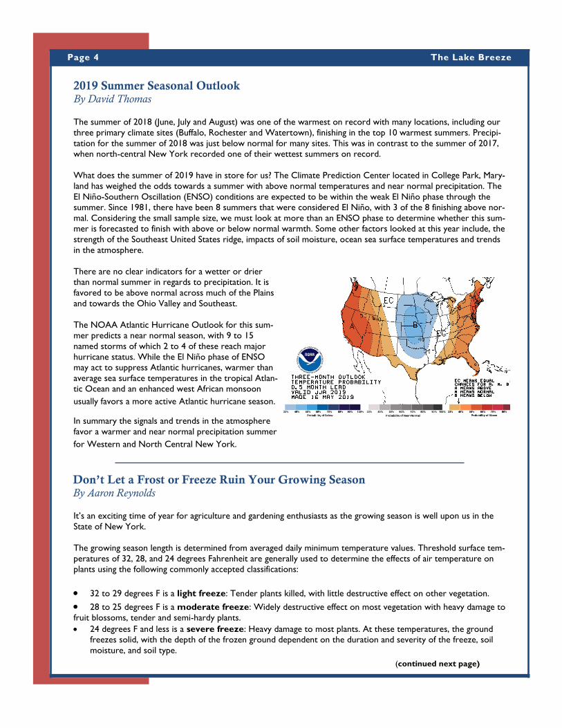
2019 Summer Seasonal Outlook By David Thomas
The summer of 2018 (June, July and August) was one of the warmest on record with many locations, including our
three primary climate sites (Buffalo, Rochester and Watertown), finishing in the top 10 warmest summers. Precipi-
tation for the summer of 2018 was just below normal for many sites. This was in contrast to the summer of 2017,
when north-central New York recorded one of their wettest summers on record.
What does the summer of 2019 have in store for us? The Climate Prediction Center located in College Park, Mary-
land has weighed the odds towards a summer with above normal temperatures and near normal precipitation. The
El Niño-Southern Oscillation (ENSO) conditions are expected to be within the weak El Niño phase through the
summer. Since 1981, there have been 8 summers that were considered El Niño, with 3 of the 8 finishing above nor-
mal. Considering the small sample size, we must look at more than an ENSO phase to determine whether this sum-
mer is forecasted to finish with above or below normal warmth. Some other factors looked at this year include, the
strength of the Southeast United States ridge, impacts of soil moisture, ocean sea surface temperatures and trends
in the atmosphere.
There are no clear indicators for a wetter or drier
than normal summer in regards to precipitation. It is
favored to be above normal across much of the Plains
and towards the Ohio Valley and Southeast.
The NOAA Atlantic Hurricane Outlook for this sum-
mer predicts a near normal season, with 9 to 15
named storms of which 2 to 4 of these reach major
hurricane status. While the El Niño phase of ENSO
may act to suppress Atlantic hurricanes, warmer than
average sea surface temperatures in the tropical Atlan-
tic Ocean and an enhanced west African monsoon
usually favors a more active Atlantic hurricane season.
In summary the signals and trends in the atmosphere
favor a warmer and near normal precipitation summer
for Western and North Central New York.
It’s an exciting time of year for agriculture and gardening enthusiasts as the growing season is well upon us in the
State of New York.
The growing season length is determined from averaged daily minimum temperature values. Threshold surface tem-
peratures of 32, 28, and 24 degrees Fahrenheit are generally used to determine the effects of air temperature on
plants using the following commonly accepted classifications:
32 to 29 degrees F is a light freeze: Tender plants killed, with little destructive effect on other vegetation.
28 to 25 degrees F is a moderate freeze: Widely destructive effect on most vegetation with heavy damage to
fruit blossoms, tender and semi-hardy plants. 24 degrees F and less is a severe freeze: Heavy damage to most plants. At these temperatures, the ground
freezes solid, with the depth of the frozen ground dependent on the duration and severity of the freeze, soil
moisture, and soil type.
Don’t Let a Frost or Freeze Ruin Your Growing Season By Aaron Reynolds
(continued next page)

Page 5 The Lake Breeze
NWS Buffalo Hosts Spring Workshop and Environment and Climate Change Canada By Mike Fries
It should be noted that temperatures near the ground may be significantly lower than official observed temperatures
that are measured near 6 feet. If you have a green thumb and like gardening you know this too well. However, if you
are just getting started, it’s important to keep track of the weather and get to know your local climate, since a frost
or freezing temperatures can quickly kill or damage tender plants. In the spring, the National Weather Service here
in Buffalo, New York begins the frost and freeze program in early May. This program
is designed to help you protect those sensitive plants against the potential danger of
a frost or freeze.
This program begins May 1st for Niagara, Orleans, Monroe, Wayne, Cayuga,
Oswego, Genesee, Wyoming, Livingston, Ontario, Erie, and Chautauqua counties. It
begins May 11th for Cattaraugus, Allegany, Lewis, and Jefferson counties. However,
across Western and North Central New York, we have what’s called micro climates
which can widely influence temperatures. Close proximity to lakes, in particular
Lake Erie and Lake Ontario, can create a stark temperature difference between the
immediate lakeshores and inland areas.
The Buffalo National Weather Service issues three products designed to assist your
gardening interests when temperatures plummet overnight. Freeze Watch: This product is designed to heighten your awareness about a possible freeze, with surface low
temperatures below 32F.
Freeze Warning: This product means that a Freeze is imminent.
Frost Advisory: This product is issued when surface temperatures are forecast to be in the mid to upper 30s on
nights with good radiational cooling conditions (e.g. light winds and clear skies).
As each winter moves into spring, most National Weather Ser-
vice offices in the country host refresher training for the forecast
staff in order to refine our skills that revolve around forecasting
and detecting severe thunderstorms and tornadoes. This year,
NWS Buffalo hosted this training on April 2 and invited our fel-
low forecasters from Environment and Climate Change Canada’s
(ECCC) Ontario Storm Prediction Centre (OSPC) to attend.
Because of this, the workshop afforded both the opportunity to
hone our severe weather skills and to do it directly with our col-
leagues we collaborate with day-to-day across Lake Ontario at
OSPC.
Presentations were made by NWS staff on topics ranging from
tornadogenesis (the development of tornadoes), radar storm in-
terrogation, utilizing lightning data, new satellite data, hydrology, aviation, social media in severe weather operations,
and last year’s severe weather season’s verification. Staff from OSPC also presented on severe weather operations at
their office and updated the NWS staff on the evolution of the Canadian radar system to updated technology that is
currently occurring across the country.
Don’t Let your Frost or Freeze Ruin Your Growing Season (continued)
Don’t let your hard work be a victim of cold temperatures
NWS Buffalo and Environment and Climate Change
Canada Meteorologists
(continued next page)

Page 6 The Lake Breeze
NWS Buffalo and Environment and Climate Change Canada (continued)
The weather is starting to get active this spring. This has afforded opportunity to put updated knowledge on severe
weather forecasting and radar techniques to use. By hosting these workshops annually upon the change of season,
your NWS will continue to be prepared to issue timely warnings to help save lives and protect property going into
the summer season. Further, a second face-to-face meeting with forecasters from ECCC in the past 12 months af-
fords better opportunity for cross border forecast alignment and warning continuity when severe weather is im-
pending.
2018-2019 Winter Summary By NWS Buffalo Winter Team (Bob Hamilton, Jon Hitchcock, David Thomas and Steve Welch)
The winter of 2018-19 was manageable,
with near to above normal snowfall and
fluctuating temperatures that finished
the winter season at or just below nor-
mal across Western and North Central
New York. Overall the winter season
did not fair much different from the pre-
vious season. The winter season began
with below normal temperatures in No-
vember, and within this cold regime the
season started much snowier than nor-
mal. A mild December and below nor-
mal snowfall eroded the early winter
snowpack. The heart of the winter sea-
son occurred in January with several
large snow events that brought a deeper
snowpack to portions of Western and
North Central New York. A quiet Feb-
ruary and March finished the winter sea-
son.
Temperatures alternated between below and above normal through the winter season, with November, January and
March below normal for most areas. November’s temperature strayed the most from normal, and through the win-
ter there only a handful of temperature records at the primary climate sites.
The 13 lake effect snow events this season was 3 more than normal. There were 4 lake effect snow events each in
the January and February months. There were two blizzard events this winter. The first blizzard event occurred
across Erie, Wyoming and Genesee counties, as well as across Jefferson and Lewis counties on January 30th. The sec-
ond event occurred February 24th and 25th across counties east of Lake Ontario.
Despite the fluctuating temperatures there was little ice jam flooding across the region this winter. There were sev-
eral Lake Erie seiche events deep into the winter season that sent ice over the ice boom and creating flooding along
the immediate Niagara River. Lake Erie froze January 23rd, just a few days past normal and then thawed with ice out
of the Lake near Buffalo on April 29th which is about two weeks past normal.
Snowfall
Snowfall for the winter of 2018-2019 was well above normal for some areas such as Buffalo and Water-
town, but near to slightly below normal for other areas such as Rochester. Generally areas just east or northeast of
(continued next page)

Page 7 The Lake Breeze
2018-2019 Winter Summary (continued)
either Lake Erie or Lake Ontario experienced above normal snowfall for the winter, with some areas like Buffalo
and the Watertown area having two feet or more above normal snowfall for the season. Areas south of the lakes
or farther inland from the lakes received near normal snowfall with a few locations having well below normal snow-
fall. With 118.7 inches of snow, Buffalo had its 12th snowiest winter on record and was 24 inches above the normal
of 94.7 inches. With 96.8 inches of snow, Rochester was slightly below the 99.5 inch normal for the season. The
118.7 inches of snow for the winter of 2018-2019 at the Buffalo Airport ranks as the second snowiest winter in the
last decade and fourth snowiest winter since the winter of 2000-2001.
The pace for the above normal snowfall that did occur in some locations was started in November 2018 when most
locations across the Buffalo forecast area received well above normal snowfall for November. December 2018 was
the only month of the winter where snowfall was below normal for all climate and Cooperative Observer locations.
Many areas received less than half the normal snowfall expected in the month of December, resulting in some of
these areas having below normal snowfall amounts for the winter. January and February 2019 for most areas was
near normal snowfall levels. The exception being well above normal snow amounts in January northeast of Lake Erie
and Lake Ontario, primarily due to a large lake effect event with blizzard conditions at the end of the month. Snow
totals for the season were generally above normal in the lake effect areas and below normal elsewhere. This was
primarily due to a repetitive feed of the very cold air into the nations mid section and Upper Great Lakes that later
moved into our forecast area. Direct shots of arctic air into the Lower Great Lakes are more favorable to multiple
band events that cover a larger area versus larger snowfalls in the lake snow-belts.
Temperatures
Temperatures for the winter of 2018-2019 were near normal for all three climate locations and most of the Buffalo
forecast area. Buffalo and Watertown were slightly colder than normal at 1.1F and 0.7F below normal respectively.
Rochester was 0.1F above normal for the winter. Temperatures at all three climate locations for November 2018
ran between four to five degrees Fahrenheit below normal. Temperatures in December 2018 were between three
and four degrees Fahrenheit above normal for Rochester and
Buffalo, while Watertown was one degree above normal. Tem-
peratures for the three climate locations for the rest of the win-
ter were within a few degrees Fahrenheit of normal.
Winter Statistics for Buffalo, Rochester and Watertown
Buffalo
Average Temperature, November – March: 30.1F (1.1F below
normal)
Snowfall: 118.7” (12th snowiest)
Days with 1.0” or more of snowfall accumulation: 31
Days with 1” or more on ground: 67
Rochester
Average Temperature, November – March: 31.3F (0.1F above
normal)
Snowfall: 96.8” (42nd snowiest)
Days with 1.0” or more of snowfall accumulation: 29
Days with 1” or more on ground: 80
Visibile satellite imagery from Terra MODIS showing ice
cover on Lake Erie and Lake Ontario and an organized
lake effect band over Lake Ontario (February 1, 2019.)
Safe Boating By Tony Ansuini
With warmer weather right around the corner, many Western New Yorkers will enjoy boating with friends and
(continued next page)

Page 8 The Lake Breeze
family during the summertime. The National Weather Service
and the National Safe Boating Council will once again partner
to support boating safety by creating safety-specific messages
for National Safe Boating Week, held from May 18-24, 2019.
The goal of the campaign is to increase boating safety aware-
ness. Each day of the week a new topic will be discussed on
our social media platforms.
Sunday: Life Jackets: Wearing a life jacket is one of the
most effective and simple life-saving strategies for safe recrea-
tional boating. The most important thing is this: remember to grab a life jacket and "Wear It!"
Monday: Fire Extinguishers: U. S. Coast Guard approved, marine-type fire extinguishers are required on boats
where a fire hazard could be expected from the engines or fuel system. The boater shouldn't have to travel more
than half the length of their boat to get to the fire extinguisher
Tuesday: Boating under the Influence: There are many dangers to boating under the influence. Protect your life and
others – never BUI!
Wednesday: Cold Water Safety: Warm air doesn’t necessarily mean the water is warm. Survival time is greatly
diminished for someone immersed in water below 70 degrees. Being prepared for an outing on cold water means be-
ing prepared for the possibility of suddenly being immersed into cold water. Your ability to survive cold water immer-
sion depends on your ability to stay afloat and to stay warm until help arrives. Below are several things to consider
prior to venturing out on cold water. Always wear a life jacket. Wear cold water protection gear for the water tem-
perature, not the air.
Thursday: Thunderstorms: Thunderstorms can be a mariner's worst nightmare. They can develop quickly and can
produce strong wind, pounding rain, deadly lightning, and hail with very few places for shelter. Even marginal thunder-
storm winds can capsize certain boats and other floating vessels. If you are out on the open water and see clouds
quickly growing in the distance, it may be thunderstorms that are developing. Don’t wait until you can hear thunder or
see lightning. It is best to head to port or safe shelter at the first sign of a developing storm.
Friday: Hurricane Preparedness: Be prepared for hurricane season. Don't wait until a hurricane warning to secure
your boat. By the time a hurricane warning is issued, it's too late to be working on a dock safely. Listen to weather
forecasts and plan ahead. Haul out your boat or add additional lines during a hurricane or tropical storm watch, which
is issued before a warning, 48-hour before the anticipated onset of storm winds.
Saturday: Marine Forecast: Understanding a marine forecast is critical to safe boating. Weather and wave condi-
tions can change suddenly, catching boaters off guard and creating life threatening conditions. Know before you Go!
Visit our website weather.gov/buf each day you plan on heading out the water.
Have a safe and enjoyable boating season!
Safe Boating (continued)
The 10th Anniversary of the Gowanda Flood By David Thomas
This summer will mark the 10-year anniversary of the historic flooding that took place in and around Gowanda in
2009. The catastrophic event was the result of a deluge of rainfall over saturated ground which resulted in flash flood-
ing across the village of Gowanda and nearby Silver Creek. Heavy rain and a rapid rise of water on Cattaraugus
Creek also impacted nearby communities, but to a lesser extent.
(continued next page)

Page 9 The Lake Breeze
A very warm and humid air mass was across Western New York on Sunday August 9th 2009. Dewpoint temperatures rose
into the lower to middle 70s which is an indication of a very moist airmass even by late summer’s standards. Early in the day
of Sunday August 9th, a line of thunderstorms formed near Toronto, Canada and dove southeastward across Western New
York. These severe thunderstorms produced widespread straight line wind damage, and also spawned a tornado near Cuba,
NY in Allegany County. In addition, one to two inches of rain fell with this system, effectively priming the region for the po-
tential for flash flooding.
Another complex of thunderstorms formed over southern Canada and dove
southeastward across Western NY Sunday night and into the early morning
hours of Monday, August 10th, 2009. The airmass remained moist during this
second round of thunderstorms which came only 8 to 10 hours after the first
complex of thunderstorms the day prior. Ahead of this second line of thun-
derstorms, a stationary boundary developed within the warm, humid airmass
and heavy thunderstorms blossomed over a narrow line from Lake Erie
through the Cattaraugus Creek basin. This stationary boundary allowed for
heavy rain to fall continuously over the same area for several hours, before
the second inundation of showers and thunderstorms hit. From 1030 PM
EDT to midnight Sunday August 9th a spotter in nearby Perrysburg N.Y.
measured an astonishing 5.98 inches of rain!
The second wave of thunderstorms advanced across
Western New York during the overnight hours of Sunday
night into Monday morning August 10th. Small tributaries
flooded and peaked in the middle of the night on August
10. One such tributary, Walnut Creek reportedly rose 3
to 4 feet in 30 minutes. As a fury of water flowed down
the steep hill sides, small creeks and streams became roar-
ing rivers which inundated the villages of Gowanda and
Silver Creek with catastrophic flooding.
In Silver Creek, residents were evacuated from a mobile
home community before it was destroyed by the flooding
waters. In Gowanda, patients of the local hospital were
evacuated. Two men lost their lives in the village of Gowanda as a
result of the disaster. It is estimated that nearly 30 percent of the
homes and businesses in Gowanda were damaged by extensive
water and mud. Roughly 80 percent of the roads in the village of
Gowanda had damage and were rebuilt. Three counties in New
York received a Presidential Disaster Declaration, with approxi-
mately $100 million needed to clean up the areas affected by this
flash flood event.
This historic event will long be remembered for the large volume of water that fell over a short period of time, and the dam-
age that was done to several communities of Western New York. Although the Cattaraugus Creek at Gowanda spiked to
historic levels, it was the small tributaries that caused the flooding in Gowanda. The Gowanda and Silver Creek events are a
reminder of how sudden and devastating flash flooding can be. Always remember to heed Flash Flood Warnings and “Turn
around, don’t drown.”
The 10th Anniversary of the Gowanda Flood (continued)
Water levels and discharge from the Cattaraugus Creek at Gowan-
da, NY.
Debris near Gowanda, NY days after the catastrophic
flooding.
“One such tributary,
Walnut Creek reportedly
rose 3 to 4 feet in 30
minutes.”

587 Aero Drive
Cheektowaga, NY 14225 (716) 565-0204
www.weather.gov/buf
Email: [email protected]
SKYWARN® News By Jon Hitchcock, Meteorologist
The spring 2019 SKYWARN severe weather spotter training season is wrapping up as we
prepare for the heart of our severe weather season. This season we held 11 training ses-
sions in 8 different counties across western and north central New York. A total of 258
spotters were trained, including over 70 in our first ever online spring SKYWARN training
session. The online meeting platform worked well, and gave an opportunity to participate in
SKYWARN for those who could not attend one of our in person training presentations.
The SKYWARN training program was started in the 1970’s by the National Weather Service
and partner organizations. The National Weather Service in Buffalo has nearly 1000 trained
SKYWARN spotters in all corners of our forecast area. They relay reports of critical severe
weather information to forecasters at the National Weather Service, allowing for more accu-
rate warnings and forecasts of severe weather impacts to the public. SKYWARN spotters
also relay reports of snow and ice during the winter, helping to better quantify snowfall
amounts and impacts from snowstorms.
During the severe weather season, we ask our volunteer SKYWARN spotters to relay re-
ports of funnel clouds, wall clouds, tornadoes, waterspouts, flooding, hail, and damaging
winds. It is vitally important that our spotters ensure their own safety first during a severe
thunderstorm. Once they are safe, then we ask that they report the severe weather.
Our first severe weather event of the year on
April 14, 2019 proved the value of near real-time
reports from SKYWARN spotters. A Tornado
Watch and several Severe Thunderstorm Warn-
ings had already been issued for Western New
York based on the favorable environmental setup
and radar data. Trained SKYWARN spotters and
the public reported large hail across Chautauqua
County, including some photos shared on social
media. These reports, coupled with radar data,
allowed forecasters to increase the hail size esti-
mates in the Severe Thunderstorm Warnings,
providing more accurate warning information to
the public still in the path of the storms. Thank
you to all our SKYWARN spotters for their help!
NATIONAL
WEATHER SERVICE
BUFFALO NY
The Lake Breeze—Spring 2019 Contributors:
Judith Levan, Meteorologist in Charge
Dan Kelly, Observation Program Leader
Bob Hamilton, Meteorologist
David Thomas, Meteorologist
Aaron Reynolds, Meteorologist
Mike Fries, Warning Coordination Meteorologist
Jon Hitchcock, Meteorologist
Steve Welch, Meteorologist
Tony Ansuini, Meteorologist
Editor:
Heather Kenyon, Meteorologist
“The National
Weather Service
provides weather,
water, and climate
data, forecasts and
warnings for the
protection of life
and property and
enhancement of the
national economy.”
Follow us! US National
Weather Service
Buffalo NY
@NWSBuffalo
Hail and rain shaft (Photo credit: Christy
McVaugh Arkwright)


