
i
THE IMPROVEMENT OF THE RURAL ACCESSIBILITY IN KABULA
LOCATION.
BY: KATIAMBO JUMA AUGUSTINE.
B65/0375/2006.
A PLANNING DEVELOPMENT PROJECT SUBMITTED IN PARTIAL
FULFILLMENT OF THE DEGREE OF BACHELOR OF ARTS IN URBAN AND
REGIONAL PLANNING,
SCHOOL OF THE BUILT ENVIRONMENT,
UNIVERSITY OF NAIROBI.
JULY 2010.
ii
DECLARATION
This Development Project is my original work and has not been presented for a degree in
any other University.
SIGNED……………………………………… DATE:……………………..
KATIAMBO J. AUGUSTINE
(Candidate)
This Development Project has been submitted for examination with my approval as
University supervisor.
SIGNED…………………………………………. DATE………………………
Mr. Z. MALECHE.
(Supervisor)

iii
DEDICATION
To my family members, my parents, my primary school and my home church.
May the Almighty God bless you all.
iv
ACKNOWLEDGEMENTS
This work would not have been successful without the moral, financial and professional
support from various individuals and institutions.
I wish to thank the University of Nairobi through the Department of Urban and Regional
Planning for the support, which made the research project a success. I am particularly
grateful to my supervisor, who is also the project coordinator, Mr. Z. Maleche for his
understanding, professional and moral assistances that enabled me to come this far with
this project.
Lastly, I thank my family for their encouragement, financial and moral support in all
ways. Above all, I give glory to the Almighty God for the sufficient grace and strength,
which enabled me to reach this far and His mercy upon my life for the strength of
working to give this wonderful output.
v
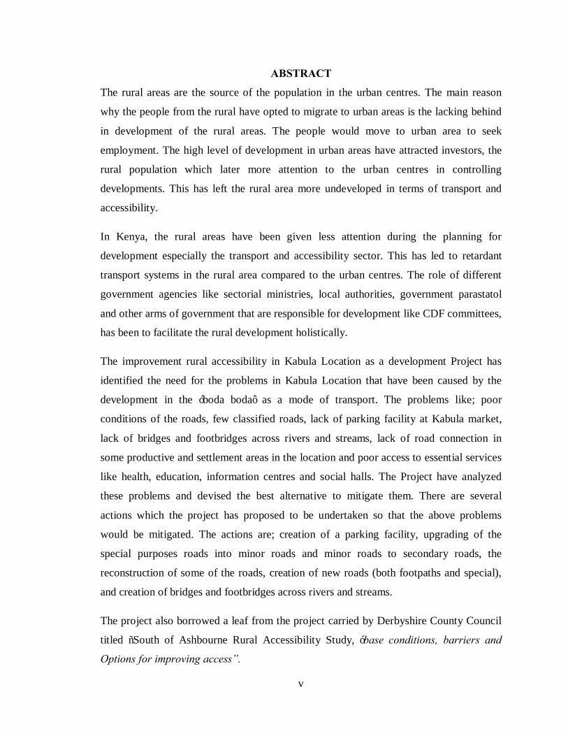
ABSTRACT
The rural areas are the source of the population in the urban centres. The main reason
why the people from the rural have opted to migrate to urban areas is the lacking behind
in development of the rural areas. The people would move to urban area to seek
employment. The high level of development in urban areas have attracted investors, the
rural population which later more attention to the urban centres in controlling
developments. This has left the rural area more undeveloped in terms of transport and
accessibility.
In Kenya, the rural areas have been given less attention during the planning for
development especially the transport and accessibility sector. This has led to retardant
transport systems in the rural area compared to the urban centres. The role of different
government agencies like sectorial ministries, local authorities, government parastatol
and other arms of government that are responsible for development like CDF committees,
has been to facilitate the rural development holistically.
The improvement rural accessibility in Kabula Location as a development Project has
identified the need for the problems in Kabula Location that have been caused by the
development in the ‘boda boda’ as a mode of transport. The problems like; poor
conditions of the roads, few classified roads, lack of parking facility at Kabula market,
lack of bridges and footbridges across rivers and streams, lack of road connection in
some productive and settlement areas in the location and poor access to essential services
like health, education, information centres and social halls. The Project have analyzed
these problems and devised the best alternative to mitigate them. There are several
actions which the project has proposed to be undertaken so that the above problems
would be mitigated. The actions are; creation of a parking facility, upgrading of the
special purposes roads into minor roads and minor roads to secondary roads, the
reconstruction of some of the roads, creation of new roads (both footpaths and special),
and creation of bridges and footbridges across rivers and streams.
The project also borrowed a leaf from the project carried by Derbyshire County Council
titled “South of Ashbourne Rural Accessibility Study, ‘base conditions, barriers and
Options for improving access”.

vi
In achieving the desired goals, several alternatives were generated. The first alternative
focused on no intervention or Nil intervention. Here the situation was left as it is and with
projections made how the Location will appear in future bearing all the problems. A
worse scenario was envisioned in the alternative with some areas being segregated due to
lack of road connections and confusions at the bus stops at Kabula market. The second
alternative has focused its actions on the road reconstruction, construction of new roads,
provision of parking, construction of bridges and footbridges and adding more classified
roads in the location. This alternative is entitled the improvement of accessibility through
road networks in Kabula Location. The third alternative based on the provision of
services at service centres in the Location. This alternative focused on ensuring all the
essential services are provided at all the service centres. The essential services to be
provide were; health services, education through both secondary and tertiary institutions,
information centres, cash points and banks, and social halls and avenues. The best
preferred alternative was chosen that would address immediate development of Kabula
location through the improvement of accessibility.
The project identified several actors that would facilitate the implementation of the
development plan. County Council of Bungoma, central government through Kenya
Rural Roads Authority (KERRA), Ministry of roads, Ministry of public works and
ministry of lands, and Kabula Community are the main actors in the implementation of
the project. CDF, LATF, Kenya roads board and Sugar Companies served by the location
are the main sources of finance to this project.
vii
TABLE OF CONTENTS
Title Pages
DECLARATION ............................................................................................................ ii
DEDICATION .............................................................................................................. iii
ACKNOWLEDGEMENTS ........................................................................................... iv
ABSTRACT ....................................................................................................................v
TABLE OF CONTENTS .............................................................................................. vii
LIST OF FIGURES .........................................................................................................x
LIST OF PLATES ...........................................................................................................x
LIST OF MAPS ..............................................................................................................x
LIST OF TABLES ........................................................................................................ xi
CHAPTER ONE: INTRODUCTION. .............................................................................1
1.1 Findings of the Planning Research Project.............................................................1
1.4 The main recommendations of the Planning Research Project. ..............................2
1.5 The Development Project chosen for implementation. ...........................................4
1.6 Reasons for the choice of the Development Project. ..............................................4
1.7 The location and area coverage of the Development Project. .................................5
1.8 Objectives of the Development Project..................................................................6
1.9 The assumptions of the Development Project. .......................................................6
1.10 The scope of the Development Project. .................................................................6
1.11 Methodology for the Development Project. ...........................................................8
1.11.1 Data needs and sources. .....................................................................................8
1.11.2 Methods of Data collection. ...............................................................................9
1.11.3 Methods of data analysis and Presentation. ...................................................... 10
1.11.4 Limitations of the Development Project. .......................................................... 10
1.12 Definitions of key terms and concepts. ................................................................ 11
CHAPTER TWO: REVIEW OF POLICY GUIDELINES. ............................................ 12
2.0 Introduction. ....................................................................................................... 12
2.1 Policy analysis – identification of various policy guidelines. ............................... 12
2.1.1 Review of the government policy on Rural Development ................................ 12

viii
2.1.2 Role of rural transport network in Development. ............................................. 13
2.2 Planning and design standards, regulatory guideline. ........................................... 21
2.3 The case study .................................................................................................... 23
2.4 Conceptual framework of the Project. ................................................................. 32
CHAPTER THREE: SITUATION ANALYSIS. ............................................................ 34
3.0 Introduction. ....................................................................................................... 34
3.1 Location context and area extent. ........................................................................ 34
3.2 Background and historical context of the project area. ......................................... 37
3.3 Physical and natural environmental characteristics of the study area.................... 37
3.3.1 Topography and relief...................................................................................... 37
3.3.2 Geology and soils. ........................................................................................... 37
3.3.3 Hydrology. ...................................................................................................... 38
3.3.4 Drainage. ......................................................................................................... 38
3.3.5 Climate. ........................................................................................................... 38
3.3.7 Agro-Ecological Zones. ................................................................................... 40
3.4 Population and demographic characteristics. ....................................................... 40
3.5 Economic activities. ............................................................................................ 41
3.5.1 Industrial activities. ......................................................................................... 41
3.5.2 Commercial, trade and services. ...................................................................... 42
3.5.3 Transport network. .......................................................................................... 42
3.6 Level of education............................................................................................... 43
3.7 Land uses in Kabula location. ............................................................................. 43
3.8 Institutional framework of the project. ................................................................ 44
3.8.1 The role of the central government in the rural transport. ................................. 44
3.8.2 The role of the Local Authority in rural transport. ............................................ 45
3.8.3 The role of private sector and Non-governmental organization. ....................... 46
Projected situation in Kabula location. ........................................................................... 47
3.8.4 Summary of the emerging issues in Kabula Location. ...................................... 49
CHAPTER FOUR: PROJECT PLANNING, DESIGN AND IMPLEMENTATION. ..... 50
4.0 Introduction ........................................................................................................ 50
4.1 Expected outputs and outcomes of the Development Projects. ............................. 50

ix
4.2 Development of a spatial plan ............................................................................. 51
4.2.1 Design of alternatives ...................................................................................... 51
4.2.2 Alternative plan proposals. .............................................................................. 52
a. Alternative 1: Improving the accessibility through extension of the road system and parking facility. ............................................................................................................. 52
b. Alternative 2: Servicing of the centres essential service provision. .......................... 55
4.2.3 Evaluation of alternatives and the Preferred plan. ............................................ 58
4.3 Site planning and evaluation. .............................................................................. 59
4.4 Critical site planning challenges and opportunities. ............................................. 59
4.4.1 Opportunities. .................................................................................................. 59
4.4.2 Challenges ....................................................................................................... 63
4.5 Detailed design formulation sections and action plans. ........................................ 64
§ The roads proposed program................................................................................... 64
4.6 Implementation strategies.................................................................................... 70
4.6.1 Implementations schedule. ............................................................................... 73
4.6.2 Implementation schedule- Period, phasing, costing and resource requirements.74
4.6.2.2 The cost of implementing the project. .......................................................... 75
4.6.3 The role of actors/implementing agencies. ....................................................... 76
CHAPTER FIVE.MONITORING AND EVALUATION OF THE PROJECTS. ........... 78
5.0 Introduction ........................................................................................................ 78
5.1 Monitoring and evaluation stage of the implementation of the project. ................ 78
5.2 Indicators of the progress of the project. .............................................................. 79
5.2.1 Guidelines for the implementation process ...................................................... 79
5.2.2 Participation guidelines. .................................................................................. 79
5.2.3 Sustainable parking facility. ............................................................................. 80
5.2.4 Guideline to rural roads and accessibility. ........................................................ 80
5.3 Site / Environment Management plan. ................................................................. 80
5.4 Conclusion .......................................................................................................... 82
REFERENCES AND BIBLIOGRAPHY. ...................................................................... 83
APPENDICES. .............................................................................................................. 85
x
LIST OF FIGURES
Figure 1: The Accessibility Planning Process 24
Figure 2: The steps for addressing accessibility problems in rural areas 25
Figure 3: The graphical representation of conceptual framework. 33
Figure 4:Different stakeholders with their roles in the development project 46
Figure 5: sketch map showing open spaces at Kabula Market 60
Figure 6: the road cross-section of proposed minor road. 68
Figure 7: The plan of Parking Facility at Kabula market 69
LIST OF PLATES
Plate 1: Crop farming and commercial activities in Kabula Location. 43
Plate 2: The elevations of the proposed parking facility 70
LIST OF MAPS
Map 1: Map showing the Kabula Location 5
Map 2: Base Map of Kabula Location as the study area. 7
Map 3: The individual settlements and the minor road network in the districts of DDDC, SDDC and AVDC. 28
Map 4: Key bus services within and around the DDDC 30
Map 5: Location of Bungoma District in National Context 35
Map 6: Location of Kabula in Bungoma District. 36
Map 7: The map of Kabula Location showing population distribution. 41
Map 8: Map of the future projection for nil interventions. 48
Map 9: Map showing alternative 1- the improved roads network. 54
Map 10: Map showing Alternative 2 - upgrading of centres. 57
Map 11: Map 9: Map of the analysis of Kabula Location 62
Map 12: Map of Kabula Location showing roads and service centres 66
Map 13: the selected roads to be upgraded in Kabula Location. 67

xi
LIST OF TABLES
Table 1: the priorities, constraints and strategies on roads by the District Development Plan. 19
Table 2: Guidelines for service centers. 21
Table 3: Universal Road carriageways standards 22
Table 4: Provision for Parking spaces 22
Table 5: The Bungoma district road lengths by the type of the road surface 42
Table 6: Role of Stakeholders in roads development under Bungoma District. 47
Table 7: The proposed distribution and upgrading of service centres in Kabula Location 55
Table 8: The roads proposal and the actions 65
Table 9: The summary of the implementation strategies 71
Table 10: site and environmental management plan. 81
xii
ACRONYMS
CBO – Community Based Organization
KRB – Kenya Roads Board
SPRS – Special Purposes Roads.
KERRA – Kenya Rural Roads Authority
KHRA – Kenya Highway Roads Authority
IMF – International Monetary Fund
EU – European Union.
MoR – Ministry of Roads
MoPW – Ministry of Public Works
NMT – Non- Motorized Transport
RMLF – Road Maintenance Levy Fund
LATF – Local Authority Transfer Fund
KRSA – Kenya Roads Safety Authority
SCDL- Smart Card Driving License
MoRPW – Ministry of Roads and Public Works
LTP – Local Transport Plan.
1
CHAPTER ONE:
INTRODUCTION.
The development of ‘boda boda’ public transport from bicycle to motorcycle mode in
Bumula division with special reference to Kabula location was the research project.
1.1 Findings of the Planning Research Project.
• Bicycles in Kabula location are being replaced by the motorcycles. The
motorcycles have emerged in Kabula location to replace the bicycle and
complement the buses, matatus and taxis in the public transport.
• The economic and accessibility needs of Kabula Location necessitated the
developing of the ‘boda boda’ service’ the need to move people to place of work,
from home to work and from work to home contributed to the development of the
‘boda boda’ .
• The need for movement of people and the luggage from the remote rural where
the motor vehicles don’t reach to the urban centre; and the moving of people back
to the rural areas with their luggage. The moving of the farm inputs from Kabula
Market to the remote rural areas and the farm produce to the market contributes to
the development of the ‘boda boda’ in Kabula Location.
• The need to access the remote rural areas faster than walking and in a decent
manner where there is no motorized vehicles contributed to the growth of the
motorcycles.
• There are many unclassified rural roads which are in poor conditions. These roads
are difficult to be used by the motor vehicle especially during the rainy season.
• The ‘boda boda’ service generates income to those unemployed in the formal
sector within Kabula Location. With the development of the motorcycle, ‘boda
boda’ income to the operators has doubled.
• The ‘boda boda’ business in Kabula location suffers insecurity cases. There have
been several attacks by the robbers and the passengers during late hours especially

2
beyond 10.00 pm or the passenger are robbed their luggage by the operators or
other robber.
• There is lack of parking facility at Kabula market. ‘Boda boda’ parking is at the
bus stop interfering with the motor vehicle transport.
• There are lack of connectivity between the villages across the rivers and streams
through bridges and footbridges.
• There are few classified roads in the location. Only roads classes C33 and E 201
are classified.
• There are only two all weather roads and one tarmac road in the location.
• There are few roads in the location has made some areas inaccessible.
1.4 The main recommendations of the Planning Research Project.
1. The poor roads in the location need to be improved for effective rural accessibility
by upgrading the roads through the graveling of all weather roads in Kabula
location.
2. There has to be a regulation and provision of enough security to the ‘boda boda’
operators to facilitate the easy and comfortable working of the business.
3. The driving hours of the motorcycles ‘boda boda’ service should be strictly
regulated. The operations should run until 9.00 p.m. and start not before 6.00 a.m.
4. The development of a comprehensive modern parking facility at Kabula market
that will accommodate the following
a. The shed for the ‘boda boda’ both the bicycles and the motorcycles. This
shed should include space for the operators, the waiting passengers, and
the motorcycles and bicycles separated within it.
b. This parking should be near the bus park to facilitate smooth transport
transfer from the ‘boda boda’ modes to the PSV modes of traditional
motorized vehicles for public transport.
c. The parking may include a restaurant for the stakeholders to have their
meals and refreshments.
d. The drainage system for the parking and the whole Kabula market controls
storm water and foul waters from the rest of the market.
3
5. The government should reduce the purchase expenses, the license fee, registration
and member plate’s fee, and the taxes imposed on the motorcycle and their spare
parts.
6. Create a ‘boda boda’ operators organization and national body like the MOA-
Matatu Operators Association. The body would serve the following:
a. A body through which the operators and passengers would air out their
grievances and needs.
b. The organization will help to check the behaviors of the ‘boda boda
operators and their misconducts.
c. The body can serve as the entry point for government benefits like grants
and loans.
d. The body would act as a CBO to the ‘boda boda’ operators where their
future may be guaranteed through investment and saving of their daily
earnings.
e. The body would manage the parking place through regulating the ‘boda
boda’ operators.
7. Create identity through either numbers or uniforms or both for the ‘boda boda’
operators especially the motorcyclist. The policy regulation of using the uniforms
to be enforced by the traffic police.
8. Training of motorcycle drivers in maintenance and repairs in order to reduce the
petty expenses incurred by the ‘boda boda’ operators for the maintaining the
business.
9. Initiate frequent training of ‘boda boda’ operators on safety measures and First
Aid assistance to equip them with the ability to handle minor injuries and
emergencies during accidents.
10. Create the insurance cover for the ‘boda boda’ which should be less than the
motor vehicles for affordability.
11. Create the speed limits for the motorcycles ‘boda boda’ operators. The speed limit
should not exceed 50km/hour for they serve the remote rural areas.
12. Initiate restrictions in the carrying capacity of the passengers the type of luggage
to be carried: a maximum of two people with the driver. In case of the children,
4
they should be not more than three and the fragile goods like electronics and the
machines of precious value like power saws, generators and water pumps be
avoided in the system.
13. Construct the footbridges and bridges that would facilitate accessibility across the
rivers and streams and between villages.
14. Construct more roads and upgrade the roads classes in the location to increase the
number of classified roads.
15. Reconstruct the roads’ surfaces, the earth roads to be covered with either murram
or gravel.
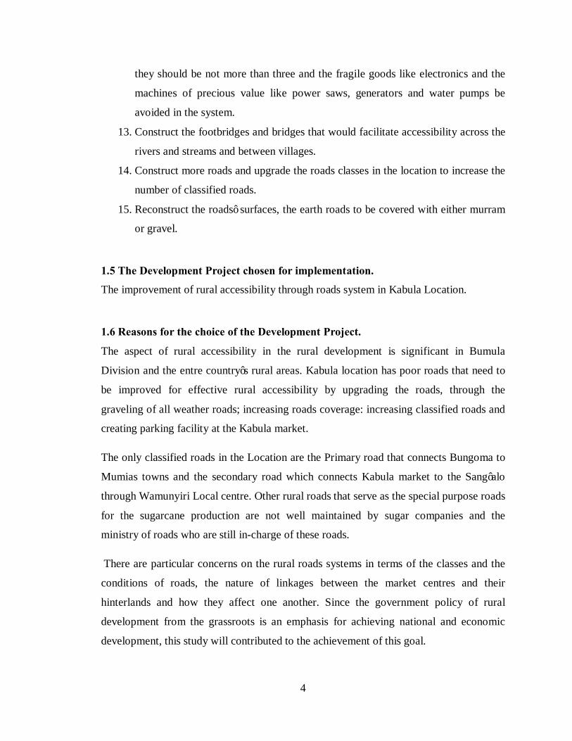
1.5 The Development Project chosen for implementation.
The improvement of rural accessibility through roads system in Kabula Location.
1.6 Reasons for the choice of the Development Project.
The aspect of rural accessibility in the rural development is significant in Bumula
Division and the entre country’s rural areas. Kabula location has poor roads that need to
be improved for effective rural accessibility by upgrading the roads, through the
graveling of all weather roads; increasing roads coverage: increasing classified roads and
creating parking facility at the Kabula market.
The only classified roads in the Location are the Primary road that connects Bungoma to
Mumias towns and the secondary road which connects Kabula market to the Sang’alo
through Wamunyiri Local centre. Other rural roads that serve as the special purpose roads
for the sugarcane production are not well maintained by sugar companies and the
ministry of roads who are still in-charge of these roads.
There are particular concerns on the rural roads systems in terms of the classes and the
conditions of roads, the nature of linkages between the market centres and their
hinterlands and how they affect one another. Since the government policy of rural
development from the grassroots is an emphasis for achieving national and economic
development, this study will contributed to the achievement of this goal.

5
1.7 The location and area coverage of the Development Project.
Map 1: Map showing the Kabula Location
Source: Author June 2010
6
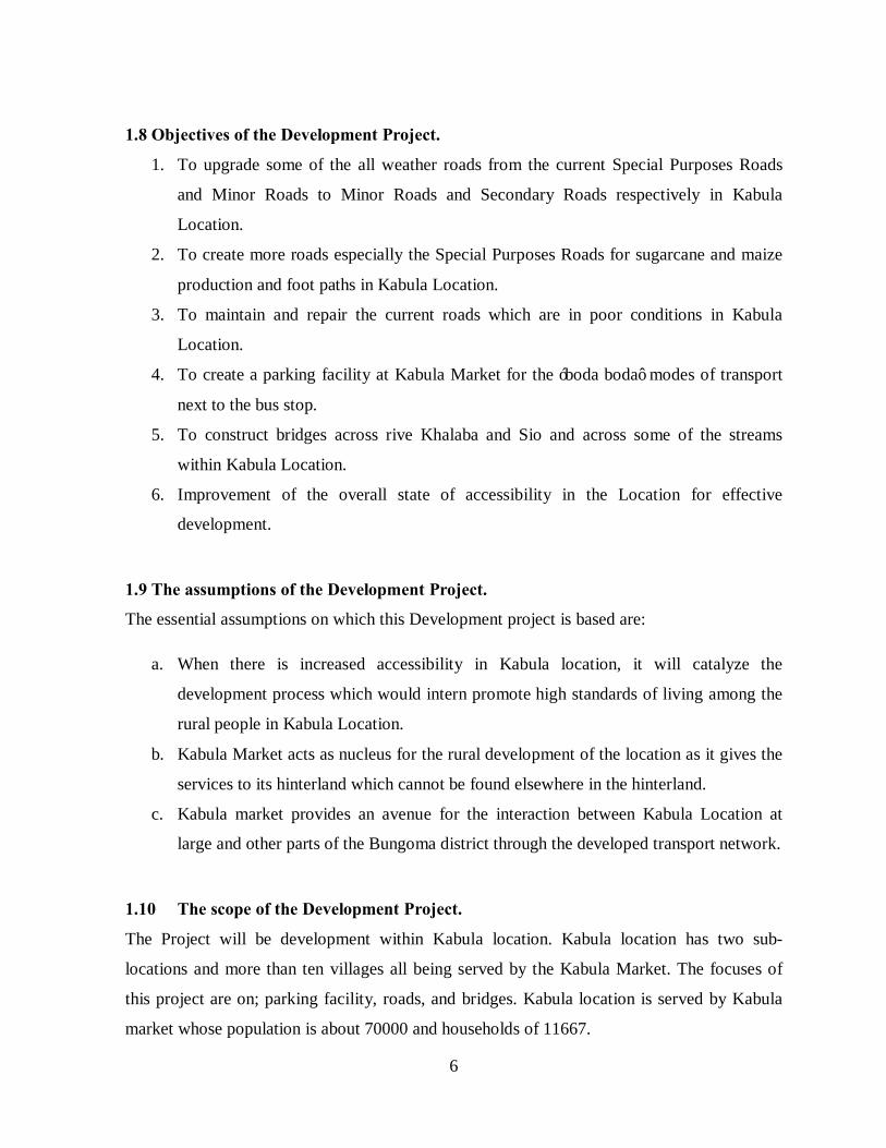
1.8 Objectives of the Development Project.
1. To upgrade some of the all weather roads from the current Special Purposes Roads
and Minor Roads to Minor Roads and Secondary Roads respectively in Kabula
Location.
2. To create more roads especially the Special Purposes Roads for sugarcane and maize
production and foot paths in Kabula Location.
3. To maintain and repair the current roads which are in poor conditions in Kabula
Location.
4. To create a parking facility at Kabula Market for the ‘boda boda’ modes of transport
next to the bus stop.
5. To construct bridges across rive Khalaba and Sio and across some of the streams
within Kabula Location.
6. Improvement of the overall state of accessibility in the Location for effective
development.
1.9 The assumptions of the Development Project.
The essential assumptions on which this Development project is based are:
a. When there is increased accessibility in Kabula location, it will catalyze the
development process which would intern promote high standards of living among the
rural people in Kabula Location.
b. Kabula Market acts as nucleus for the rural development of the location as it gives the
services to its hinterland which cannot be found elsewhere in the hinterland.
c. Kabula market provides an avenue for the interaction between Kabula Location at
large and other parts of the Bungoma district through the developed transport network.
1.10 The scope of the Development Project.
The Project will be development within Kabula location. Kabula location has two sub-
locations and more than ten villages all being served by the Kabula Market. The focuses of
this project are on; parking facility, roads, and bridges. Kabula location is served by Kabula
market whose population is about 70000 and households of 11667.
7
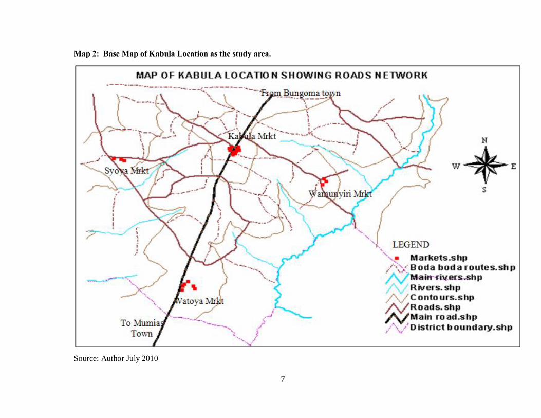
Map 2: Base Map of Kabula Location as the study area.
Source: Author July 2010

8
1.11 Methodology for the Development Project.
In the carrying out of this development Project, the approach used involved several stages.
First stage was the familiarization of the study area with an extra attention on the study
topic. Second stage involved the identification and definition of types of data needed and
their sources. Third stage involved the collection of data on the study area and the study
topic. Fourth stage was the data processing and analysis, and finally the interpretation of the
findings.
1.11.1 Data needs and sources.
In the collecting of the data, the study incorporated two types of data, primary and secondary
data.
There are few sources of data in this project. The main source is the government printer-outs
like the Purple book, human settlement in Kenya, physical planning handbook, Development
plans and District Development Plans. Other sources included the other Development
Projects that addressed the study topic or the study area, the field surveys that was carried
out by the author and the public offices that offer administration on the study topic.
• Primary data.
The primary data was collected through formal interviews by use of questionnaires. Four
sets of questionnaires were administered, bicycle ‘boda boda’, motorcycle ‘boda boda’,
households and traffic police officer. Interviews and discussions were conducted with ‘boda
boda’ operators and personal interviews with the households and other relevant persons and
authorities such as administration officers and the local authority. Personal observations of
the existing situation were also made. Photography was used too.
The data collected were on the status of transport and accessibility, the road status and the
economic activities, the problems of ‘boda boda’ and their challenges in Kabula location.
This helped to achieve the idea situation on the area of study and involve people who would
be affected by this project and get their ownership.

9
• Secondary data
Secondary data was obtained from publications in libraries on past study work, official
documents especially from the District and government offices and County Council. The
data collected was useful in determining the place of rural transport system in the
government in planning policies.
Several data were collected in this type; data on government policy on roads and
accessibility; policy guidelines on parking, road standards and bridges; institutions and
administrative frameworks of the Development projects.
1.11.2 Methods of Data collection.
Sample size and procedures.
The Bumula Division was considered as a planning region. Kabula Location was taken as
the area of study because of the advancements in the ‘boda boda’ services and the road
conditions. In Kabula location the largest urban centre is the Kabula Market which links
with other markets like Syoya, Watoya, Sibembe, Wamunyiri, Malinda and Talitia.
Two sampling techniques were used:
A random sample was done to both ‘boda boda’ cyclists and the motorcyclists in Kabula
location. There are 40 motorcycles ‘boda boda’ and about 46 bicycle ‘boda boda’ within
Kabula location.
There will be a systematic random sample of the households within the Kabula location.
Kabula location has an estimated population of 70,000 with a household size of six persons.
There were 20 questionnaires administered to the households for the research to acquire the
views from the households in Kabula location.
Photography – this involved taking photographs of the road status open spaces and
economic activities.
Questionnaires – the questionnaires were administered to get data from the ‘boda boda’
operators and the households on their demands about the accessibility in the location.
10
1.11.3 Methods of data analysis and Presentation.
There are three methods of data presentation. These involved the maps, figure and the
photographs in form of plates and illustrations, finally there is report writing. The data was
analyzed through the reports graphs and tables.
1.11.4 Limitations of the Development Project.
There are many aspects that were studied as far as the rural transport and accessibility and
development is concerned. The study narrows down to looking at rural transport and
accessibility systems and the modes used in Kabula Location. Besides this the problem
encountered in rural developments that are taken into consideration is the market centre as
nucleus of development for its hinterland, opening opportunities for trade and employment.
The study was carried out with a number of obstacles that hampered the smooth carrying out
of the study while in the field. In collecting information a number of respondents gave
partially true or distorted information with fear of being victimized and other respondents
were illiterate. Taking of photographs was quite a difficult task to accomplish as the study
was met with hostility and suspicions from the respondents.
The study area being located in remote rural had relevant documents and maps unavailable
from the government offices and the County Council. Even though some information was
available in those offices, it was still treated ‘confidential’ and not accessible to the public
especially from the County Council of Bungoma. Therefore data from the large Bungoma
District was used.
The other limitations were finance and time, which resulted into the selection of sample size
of 44 respondents among them 20 households, 13 bicycle ‘boda boda’, 10 motorcycle ’boda
boda’ and one traffic Police officer were interviewed. There were limited financial resources
for field work that researcher assistants and materials used needed, therefore no researcher
assistants used. There was little time for the study to carry out good sample that would give
fair representation of the real situation in the area.

11
1.12 Definitions of key terms and concepts.
Rural: This is a settlement, whose occupation is primarily agrarian, these settlement often
lack basic infrastructure such as electricity, pipe-borne water and good roads.
Rural Accessibility: This is defined as the access from the urban centres and its
surroundings to the rural area through the rural roads systems which includes minor roads
and Special Purposes roads. It also involves availability of basic services to the rural
population.
‘Boda boda’: Public transport taxis system where bicycles and Motorcycles are used on the
basis of hire or on payment of fare.
Market centre: This is an area that serves 60 to 100 square meters in a well populated area
with a minimum population of 15,000 in its hinterland.
Transport: This is the means by which persons and goods and certain services can be
moved from place to another over space.
Rural Development: This is a strategy designed to improve the economic and the social life
of the people who live in the rural area
Special Purposes Roads: These are roads that serve particular schemes or crop growing
region like Sugarcane, Coffee Tea, Flower and Pyrethrum. The roads are usually maintained
by the concerned factories or companies within its jurisdiction.
Minor Roads: These are any roads linking to a minor centre. The roads have a minimum
length of 3.5 kilometers.
12
CHAPTER TWO:
REVIEW OF POLICY GUIDELINES.
2.0 Introduction.
This chapter seeks to examine several government policies that concern the rural
accessibilities and rural transport for that was to enhance the rural development. The role of
accessibility in development is also examined.
2.1 Policy analysis – identification of various policy guidelines.
Several government policies ranging from the previous National Development Plans since
1964- 1970, Bungoma District Development plans and the Human Settlement in Kenya, A
Strategy for Urban ad rural development (Purple book) 1978 were reviewed.
2.1.1 Review of the government policy on Rural Development
a) Growth centers in Kenya
In the Kenyan context, growth centers are an integral part of the concept of physical
Development planning as outlined the 1970-1974 Development Plan. Others see it as a
much broader concept in Kenya in essence it entails a synthesis of development. There are
four main types of designated growth centers: Urban Centre, Rural Centre, Market Centre
and Local Centre in descending order of importance and size. Other types of growth centre
have emerged in Kenya namely the City Centre and the Metropolitan Centre.
Urban centre
These are medium size towns in the Kenya context which have been designed to service as
the focal points for commercial, industrial, administration, recreational, and social services
required by the rural population. Generally, they are meant to contain the District
headquarters. The Development plan estimates to have a residential population of over 5,000
while the catchment of rural hinterland of between 100,000 – 150,000. It should therefore be
the location for a fully equipped hospital, secondary school to Form VI level and other
specialized services. There were 36 designated urban centers in Kenya by the year 1978. In
13
Bungoma district, there were only three urban centers by year 1978 (Purple Book), namely:
Bungoma, Webuye and Kimilili,
Rural centre
They are the next highest level of Designated Service Centre. There are designated for
economic development of the rural areas. They serve at least 40,000 people in the rural and
may have a residential population of 2,000 – 10,000. They will become small towns though
with the high residential population while representing the lowest hierarchy of urban. It is
planed to concentrate administration and other services in these centre and to service them
with public water supply, electricity and all-weather roads of both the Minor and secondary
roads. These rural centers are felt to be the most suited for the development of rural cottage
industries. There were 140 such designated centre in Kenya by the year 1973.in Bungoma
district there were only five Rural centers by year 1978 (Human settlements in Kenya,-
government of Kenya).
Market centre.
They have been designated for development of a lower level of services for a rural
population of at least 15,000. The market centre are well served by a minor road as a
minimum and will have a residential; population of less than 2,000. There were 231 market
centers planned in Kenya, 17 of market centre were in Bungoma district by the year 1978
where Kabula Market from Kabula Location was among them.
Local centre.
The local centre is designed to serve a rural population of at least 5,000. Their residential
population planned was not more that 200 and although they have no administrative
functions. The centers are to be served by minor roads at minimum which are all-weather
roads. There were over 30 local centers in Bungoma district, among them were Sibembe and
Watoya centers from Kabula location.
2.1.2 Role of rural transport network in Development.
Transport plays a very important role in the operation of human settlements as integrating
centers of human activity. The achievement of some level of equitability between different
areas and a more integrated and balanced level of growth between urban and rural areas. It
14
should be realized that no uniform pattern of road network can be achieved. This is because
in Kenya the Physical and Economic conditions and levels of development vary from one
area to another.
The general principles guiding the planning of the transport system in Kenya.
1. All principal towns (growth centre) should progressively be linked by the national
trunk road system as a minimum.
2. All designated urban centre should progressively be linked by means of primary
roads as a minimum.
3. All designated rural centre should progressively be linked by means of secondary
roads as a minimum.
4. All designated market centre should progressively be linked by means of minor
roads as a minimum.
Government Policies on Transport in the Rural Development Plans.
The importance of transport is strikingly clear in the contrast between a village that has
ready access to market and one that is without an all-weather road connection or perhaps any
road whatsoever. In the latter case there is little knowledge of the outside world, no
scientific method of agriculture, no cash coming in the village, no health services, veterinary
services or adequate means f education. Crops are disposed off for what they can bring
locally.
The national Development Plans had the objectives for providing and improving
accessibility to the rural people to overcome these challenges and limitations.
Ø 1964-1970 Development Plan
It was government priority to develop all types of roads to enable communications to keep
pace with the general development in the country. The development of the trunk roads was
emphasized and the secondary roads for the agricultural potential areas.
The priority was to improve the high level roads linking the principal towns in Kenya. The
government policy seamed silent about the development of rural roads that play a role in the
rural development.
15
Ø 1970-1974 Development Plan.
The major emphasis was on the feeder and minor roads in the rural areas. New roads were to
be built to open up the new ones where no roads existed. Secondary and minor road network
were to be reassessed in order to predict the types of construction that would ultimately be
needed for the different routes. This was supposed to involve the reclassification of virtually
the whole road network. The plan acknowledged the urgent need for road maintenance
which was insufficiently done.
Ø 1974-1978 Part II Development Plan.
In this period, the focus was on the construction and maintenance of all classified roads by
the Ministry of Works. The road categories were:
International Trunk Roads (Class A): Roads linking centers of international importance
and crossing international boundaries or terminating at the international ports.
National Trunk Roads (Class B): Roads linking national important centres, such as
municipalities and/or district headquarters.
Primary Roads (Class C): Roads linking the regional/provincial centre to each other or
high class roads. The designated urban centers are linked by these roads in the region.
Secondary Roads (D)- roads linking locally important centers to each other, to a more
important centre or to higher class road.
Minor Roads (E): roads linking local and market centers and the centers with higher class
roads. They range between 3 to 5 kilometers.
Special Purpose Roads: roads that serve particular schemes or agricultural zones. E.g. the
Sugar-cane scheme roads, forest roads and Tea zone roads
Ø 1979-1983 Part I Development Plan,
In this development plan, the government recognized the fact that adequate transport
facilities played an important role in the development of the country, more particularly, the
road transport sector, because the roads can reach the remote parts of the country and a wide
16
variety of people engaged in diverse activities. Therefore the emphasis of the plan was the
development of the rural areas and the classification of the road network so as to permit all-
weather access from the rural farms to the market. With this objective, the government set
up a program of gravelling, bridging and culverting the secondary and minor roads.
Ø 1979-1983 Part II Development Plan.
During this period, the government was to give special attention to the provision of
underdeveloped links and bridges and improvement of existing classified as well as rural
access roads throughout the country.
Ø 1984-1988 Development Plan.
The national road network extended to 5,458 kilometers of which 6,721 were paved. The
total network, about 12% of the roads were classified as international and trunk roads, 14%
as primary roads, 67% as secondary roads and minor roads (including rural access roads),
and 7% as special purpose roads. The plan period was part of an emphasis towards
strengthening of paved roads towards up-grading and maintenance of unpaved roads already
in place. Also the motorized mode of transport was a focus of the government policy.
The role of the private sector was realized as important in the development of the road
transport by the fact that the bulk of the commercial and passenger vehicles were privately
owned.
Ø 1989-1993 Development Plan
During the plan, the previous road was to be upgraded, strengthened and rehabilitated with a
view to improving of transport and accessibility in all corners of the country especially in
rural areas. Priority was to be given to further enhancement of Rural Access Roads and
Minor Roads Programmes. For Bungoma district then, to ease the pressure on road
passenger transport, consideration was to be given to enhancing the contribution of the rail
system to passenger transportation along the Nakuru- Malaba railway line.
17
Ø 1994-1996 Development Plan.
During this period, the government would mainly be concerned with the provision of funds
for additional transport and to cost-effective utilization of the facilities. The goal was to
improve the efficiency and the sustainability of the existing transport system through the
mobilization of human and financial resources and the restructuring of the institutional
framework
Besides, the government, during this period was to pursue a policy framework for the
development of multi-modal transport in Kenya so as to enable the country’s domestic and
external trade to benefit from improved and efficient door to door transport.
Ø 1997-2001 Development Plan.
The policy initiatives that the government was to pursue were, the government was to give
to priority to maintenance and rehabilitation of existing roads. This was to include intensive
efforts on:
i) Improving road maintenance by strengthening the management and institutional
framework for management of roads. Action was to be taken to strengthen the
technical; and policy making capacity of the ministries concerned.
ii) Capacity building and increased reliance on the private sector on road
maintenance and construction.
iii) Provision of adequate funding for road maintenance, including urban roads.
iv) Establishment of guidelines for transport management and use of road
maintenance funds.
v) Modalities for setting priorities for road investments.
vi) Establishment of additional dual carriage ways and replacement of roundabouts
with Flyovers and traffic signals.
vii) Make provisions for pedestrian and bicycle route along future roads.
This plan is skewed towards improving the transportation system in urban areas, with little
emphasis on the rural area. The little indication of concern for the rural area was

18
maintenance and rehabilitation of the roads pedestrian and bicycle routes which however
were still not specific to the rural area.
Ø 2002 – 2008 Development plan.
This plan aimed at giving highest priority to the completion of viable on-going and stalled
projects. The government was also to maintain, rehabilitate and reconstruct existing facilities
as well as upgrading the quality of service delivery. the broads strategies of this plan was to
address infrastructure deficiencies includes application of joint ventures and, streamlining
the tendering and procurement procedures to minimize abuse and promote professionalism
in construction projects. Other strategies in this plan were to liberalization, restructuring,
privatization, improvement and modernization of existing facilities.
The plan identified several bottlenecks for the roads development;
1. Inadequate resources from the government for development and maintenance of
roads due to critical financial constraints.
2. Lack of other infrastructural facilities such as footpaths for pedestrians, separate
lanes for cyclists or non-motorized transport modes (NMT), streetlights, and flyovers
and by-passes to ease traffic congestion.
3. There is high vehicle operating costs, high fares charged for public transport, and
unstable delivery schedules due to poor state of the road infrastructure.
The inception of the Roads Maintenance Levy Funds (RMLF) in 1993 was to address the
financial constraints. Although this fund has grown over the years from Kshs. 2 billions in
1995/96 to 8 billions in 2001/2002. The local authorities also get a share through the Local
Authority Transfer Fund (LATF) for service delivery and road maintenance.
During this plan period, the government was to establish a Kenya Road Safety Authority to
oversee safety matters pertaining to road transport services, introduce new generation Smart
Card Driving License (SCDL); provide technical assistance to traffic police and the Director
of Vehicle Inspection, and train personnel working on road safety related programmes.

19
• Bungoma District Development Plan 2002-2008
This plan had a vision for enhanced and sustainable economic growth, the sector was to
provide physical infrastructure through rehabilitation, improvement and effective
management of the existing infrastructure facilities. The sector was to focus on measures
aimed at improving both quality and quantity of facilities that are likely to generate greater
economic impacts in the economy at a medium term, and in the long run, the sector is
expected to be a leading input in the countries overall goal of poverty alleviation by
providing an efficient basic road network.
The district will endeavour to ensure that the state of the roads and other physical
infrastructure necessary for fostering the growth of the economy is in acceptable condition.
Table 1: the priorities, constraints and strategies on roads by the District Development Plan.
Priorities Constraints Strategies
Routine maintenance of
existing roads network.
(graveling, grading, spot
improvement, bush clearing,
culverts);
open up new roads;
Construction of new bridges
and maintenance of existing
ones.
Financial;
Inadequate plant and
equipment;
Lack of skilled personnel;
Lack of capacity in the
private sector to undertake
contracts.
Undertake minor works
directly by MORPW
especially grading;
Contract out those major
works;
Solicit for adequate funding ;
Promote local contractors.
Source: Bungoma District development Plan 2002-2008
The problems of the Rural Transport in Development.
The problems of rural transport can be classified as supply or demand- related (Ogundana
1986). In the latter, there are at least six elements of rurality which affect an efficient,
effective provision of rural transport facilities. These are the smallness of traffic volume,
distance over which traffic moves, dispersed spatial derivation of traffic, bulkiness and
20
perishability of rural produce, imbalance of inflow and outflow of traffic, marked variability
in demand for rural transport.
The above mentioned features of the rural environment influence the level and structure for
rural transport. For example the agricultural products that are highly perishable will
therefore demand quick action to prevent substantial losses. When transport facilities are
either lacking or are costly, crops that would incur high cost are sometimes abandoned and
left unshipped to urban markets or other urban centre.
Another problem is the dispersed spatial scarcity of traffic. This dispersed pattern puts a
strain on rural transport demand. In addition many of the rural villages are poorly connected,
which can present a free flow of traffic at a low cost.
On the supply side, rural transport is influenced by the route quality, density and the
commercialization of the different media of transport. The quality of roads, imposes special
limitations on transport functioning and serviceability. The head portage system is used
extensively at the household level for carrying low-value products. However in most parts of
the rural area, farmers own or rent bicycles to move their products to market, in the market
centers or urban centers. People also wait at the road side for an available vehicle as well,
either to transport their goods or to procure a ride themselves. Since rural transport is not
coordinated, much time is lost waiting.
The frequency and speed, at which high-order goods circulate in the rural areas especially on
market days, are closely associated with the provision of rural transport environment. A
faster circulatory system of rural products and urban goods and services will generate higher
income. Adequate provision of transport in rural areas can also permit better use of rural
land (Chilsom 1966). Unimproved rural transport could confine rural land use to a narrow
belt, hindering the exploitation of the rural economy in the areas of agriculture. The
agricultural extension workers, traveling doctors, mobile banks and clinics particularly
useful in rural areas where roads are tarred and thus useful year round.
The village with a good road and some degree of dependable bus and truck services presents
a very different picture, seed, fertilizer and other inputs for intensive agriculture finds their
way into settlements. Cash crops are marketed regularly and consumer’s goods can be
21
purchased at the market place. Children travel by bus to school, the agricultural extension
worker and the veterinarian reach their settlement.
2.2 Planning and design standards, regulatory guideline.
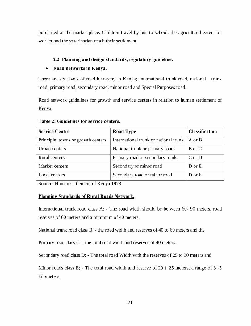
• Road networks in Kenya.
There are six levels of road hierarchy in Kenya; International trunk road, national trunk
road, primary road, secondary road, minor road and Special Purposes road.
Road network guidelines for growth and service centers in relation to human settlement of
Kenya..
Table 2: Guidelines for service centers.
Service Centre Road Type Classification
Principle towns or growth centers International trunk or national trunk A or B
Urban centers National trunk or primary roads B or C
Rural centers Primary road or secondary roads C or D
Market centers Secondary or minor road D or E
Local centers Secondary road or minor road D or E
Source: Human settlement of Kenya 1978
Planning Standards of Rural Roads Network.
International trunk road class A: - The road width should be between 60- 90 meters, road
reserves of 60 meters and a minimum of 40 meters.
National trunk road class B: - the road width and reserves of 40 to 60 meters and the
Primary road class C: - the total road width and reserves of 40 meters.
Secondary road class D: - The total road Width with the reserves of 25 to 30 meters and
Minor roads class E; - The total road width and reserve of 20 – 25 meters, a range of 3 -5
kilometers.

22
Table 3: Universal Road carriageways standards
Road type Carriageway (meters) Footpaths
International trunk and major road. 7.5 2
Commercial and industrial streets 7.0 2
Spine roads and bus routs 7.0 2
Access road (residential urban area) 5.5 2
Source: Physical Planning Handbook 2005.
The standard provision for the footpaths shall be 2 meters wide footway on each sides of the
carriageway.
Pedestrians shall be physically separated from moving vehicles by a barrier such as an up
stand kerb, open drain or wide verge.
Table 4: Provision for Parking spaces
Vehicles Parking area (meters)
Cars 5 -6 by 2.5
Buses 10 by 3.3
Trailers and trucks 30.0 by 4.0
Source: Physical Planning Handbook 2005.
Bikeways and walkways planning.
The planning of bikeways and walkways depends on;
1) Accommodation of the bicyclists and pedestrians
2) Providing appropriate facilities.
3) Creating and maintaining a system of closely spaced interconnect local streets.
4) Overcoming barriers such as freeways crossing intersections, rivers and congou’s
Rural bikeways.
On most rural roadways shoulder, bikeways are appropriate, accommodating cyclists with
few conflicts with major vehicles. Shared roadways are adequate on low-volume rural roads
where motor drivers can safely park, bicycles due to the low, likelihood of encountering on-
coming traffic.

23
However the shoulder bikeways can be added to roads with high bicycle se, such as in semi-
rural residence areas or close to urban areas. It may be appropriate to stripe and mark
shoulders as bike lanes near schools or others areas of high use.
2.3 The case study
South of Ashbourne Rural Accessibility Study:
“Base Conditions, Barriers and Options for Improving Access.”
Derbyshire County Council’s second Local Transport Plan (LTP) had priorities for the
period 2006 – 2011. One of its key priorities was to improve local accessibility. In order to
achieve this, the LTP included an Accessibility Strategy which identified that, in an area to
the south of Ashbourne, there were a large number of villages and hamlets that have limited
access to services and facilities. This was confirmed, independently, through work
conducted by Derbyshire Dales District Council (DDDC) during the preparation of their
Local Development Framework (LDF) Core Strategy.
Scott Wilson Ltd was commissioned by DDDC to:
ü Identify how settlements “cluster” in the provision of services and facilities (i.e. from
where do households living in individual settlements access services and facilities),
ü Assess current ways in which people within the study area access facilities and
services,
ü Identify barriers preventing people within the study area accessing particular
facilities and services,
ü Consider how access to services and facilities from within the study area could be
improved.
Given that the study area falls within Derbyshire County Council, Derbyshire Dales District
Council and South Derbyshire District Council areas, the study was steered by officers from
all three councils in order to provide a cross-border approach. Indeed, the results of this
study was used to inform the development of Derbyshire Dales and South Derbyshire
District Councils’ LDF process, and also to assist in the delivery of the Derbyshire
Accessibility Strategy.
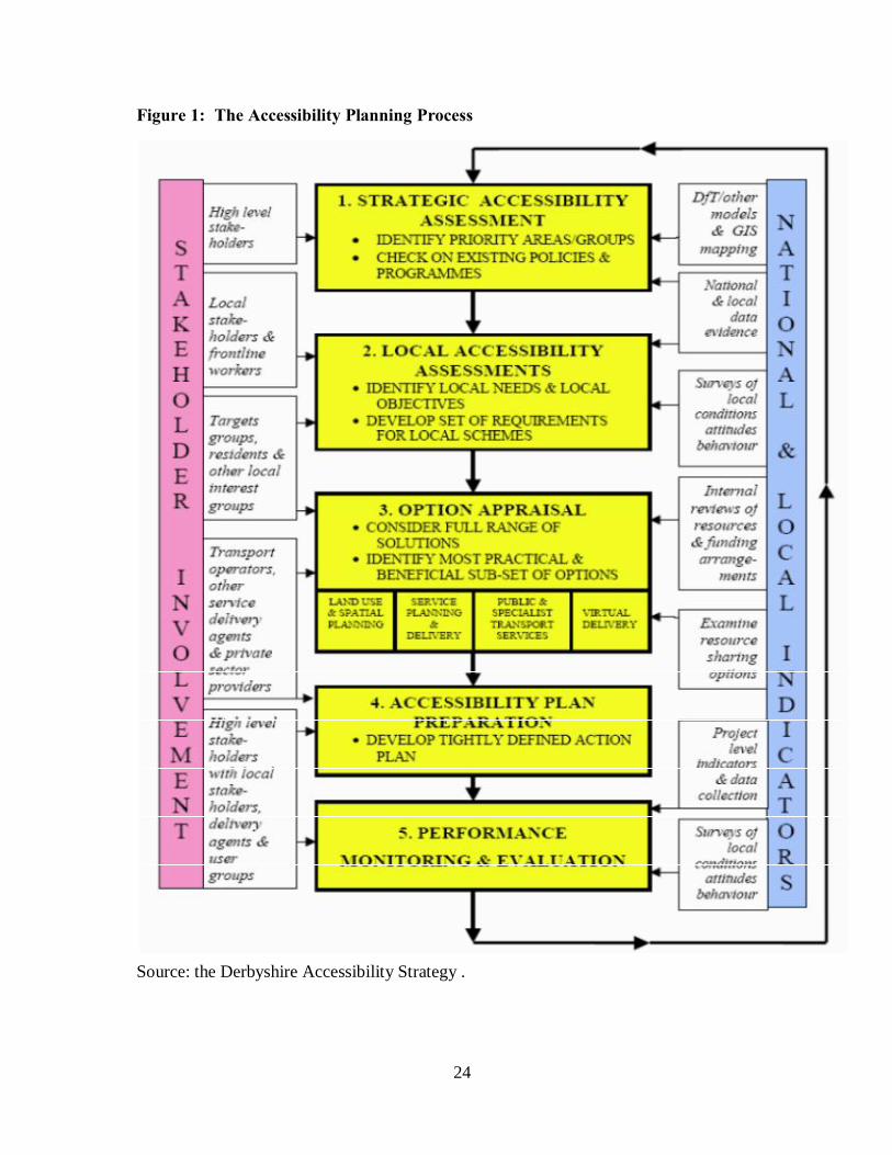
24
Figure 1: The Accessibility Planning Process
Source: the Derbyshire Accessibility Strategy .

25
The Objectives of this study are to:
• Identify how settlements “cluster” in the provision of services and facilities (i.e. from
where do households living in individual settlements access services and facilities),
• Assess current ways in which people within the study area access facilities and
services,
• Identify barriers preventing people within the study area accessing particular
facilities and services,
• Consider how access to services and facilities from within the study area could be
improved.
Methodology
The methodology developed in response to the brief sought to consult both users and
providers of accessibility services. It provides a good fit with the publication “Getting the
Solution Right: A Guide for Improving Access to services for Rural Communities” published
by the Yorkshire and Humberside Assembly. This outlined a seven step system to
addressing accessibility problems in rural areas, which is summarized in Figure below.
Figure 2: The steps for addressing accessibility problems in rural areas
Source: the Derbyshire Accessibility Strategy.
26
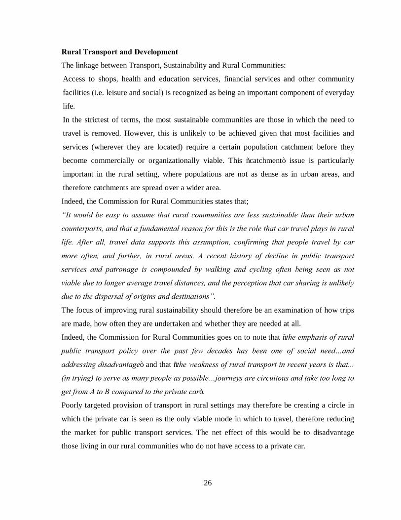
Rural Transport and Development
The linkage between Transport, Sustainability and Rural Communities:
Access to shops, health and education services, financial services and other community
facilities (i.e. leisure and social) is recognized as being an important component of everyday
life.
In the strictest of terms, the most sustainable communities are those in which the need to
travel is removed. However, this is unlikely to be achieved given that most facilities and
services (wherever they are located) require a certain population catchment before they
become commercially or organizationally viable. This “catchment” issue is particularly
important in the rural setting, where populations are not as dense as in urban areas, and
therefore catchments are spread over a wider area.
Indeed, the Commission for Rural Communities states that;
“It would be easy to assume that rural communities are less sustainable than their urban
counterparts, and that a fundamental reason for this is the role that car travel plays in rural
life. After all, travel data supports this assumption, confirming that people travel by car
more often, and further, in rural areas. A recent history of decline in public transport
services and patronage is compounded by walking and cycling often being seen as not
viable due to longer average travel distances, and the perception that car sharing is unlikely
due to the dispersal of origins and destinations”.
The focus of improving rural sustainability should therefore be an examination of how trips
are made, how often they are undertaken and whether they are needed at all.
Indeed, the Commission for Rural Communities goes on to note that “the emphasis of rural
public transport policy over the past few decades has been one of social need…and
addressing disadvantage” and that “the weakness of rural transport in recent years is that...
(in trying) to serve as many people as possible…journeys are circuitous and take too long to
get from A to B compared to the private car”.
Poorly targeted provision of transport in rural settings may therefore be creating a circle in
which the private car is seen as the only viable mode in which to travel, therefore reducing
the market for public transport services. The net effect of this would be to disadvantage
those living in our rural communities who do not have access to a private car.

27
Roles and Responsibilities
1. Within the study area, Derbyshire County Council (DCC) is the local transport
authority. DCC has the responsibility for providing socially necessary services and
public transport infrastructure though, since the 1986 Transport Act, most bus-based
public transport services have been operated on a commercial basis by private
companies.
2. Funding for other specific rural transport schemes are provided by a variety of
bodies, such as regional development agencies.
3. Until recently, most rural regions also had Rural Transport Partnerships, which are a
Countryside Agency initiative aimed to improve the quality of transport in rural
areas. However, none of the Derbyshire Rural Transport Partnerships operated
within the study area.
4. In terms of development, the planning authorities for the area are Derbyshire Dales
District Council (DDDC), South Derbyshire District Council (SDDC) and Amber
Valley District Council (AVDC).
The Study Area
The study area is located in the south of Derbyshire, south of the town of Ashbourne and
west of Derby. It is broadly bounded by the A52, A50 and the River Dove which forms the
Derbyshire / Staffordshire border.
Figure below shows the study area’s relationship to the wider area, with Figure bellow
showing the individual settlements within the study area, the minor road network, and how
the study area is split across the districts of DDDC, SDDC and AVDC.
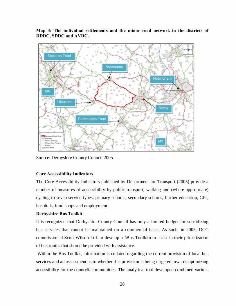
28
Map 3: The individual settlements and the minor road network in the districts of DDDC, SDDC and AVDC.
Source: Derbyshire County Council 2005
Core Accessibility Indicators
The Core Accessibility Indicators published by Department for Transport (2005) provide a
number of measures of accessibility by public transport, walking and (where appropriate)
cycling to seven service types: primary schools, secondary schools, further education, GPs,
hospitals, food shops and employment.
Derbyshire Bus Toolkit
It is recognized that Derbyshire County Council has only a limited budget for subsidizing
bus services that cannot be maintained on a commercial basis. As such, in 2005, DCC
commissioned Scott Wilson Ltd. to develop a “Bus Toolkit” to assist in their prioritization
of bus routes that should be provided with assistance.
Within the Bus Toolkit, information is collated regarding the current provision of local bus
services and an assessment as to whether this provision is being targeted towards optimizing
accessibility for the county’s communities. The analytical tool developed combined various
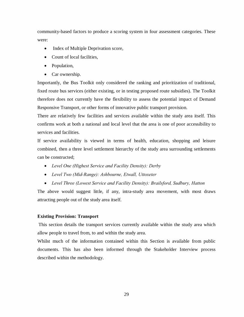
29
community-based factors to produce a scoring system in four assessment categories. These
were:
• Index of Multiple Deprivation score,
• Count of local facilities,
• Population,
• Car ownership.
Importantly, the Bus Toolkit only considered the ranking and prioritization of traditional,
fixed route bus services (either existing, or in testing proposed route subsidies). The Toolkit
therefore does not currently have the flexibility to assess the potential impact of Demand
Responsive Transport, or other forms of innovative public transport provision.
There are relatively few facilities and services available within the study area itself. This
confirms work at both a national and local level that the area is one of poor accessibility to
services and facilities.
If service availability is viewed in terms of health, education, shopping and leisure
combined, then a three level settlement hierarchy of the study area surrounding settlements
can be constructed;
• Level One (Highest Service and Facility Density): Derby
• Level Two (Mid-Range): Ashbourne, Etwall, Uttoxeter
• Level Three (Lowest Service and Facility Density): Brailsford, Sudbury, Hatton
The above would suggest little, if any, intra-study area movement, with most draws
attracting people out of the study area itself.
Existing Provision: Transport
This section details the transport services currently available within the study area which
allow people to travel from, to and within the study area.
Whilst much of the information contained within this Section is available from public
documents. This has also been informed through the Stakeholder Interview process
described within the methodology.
30
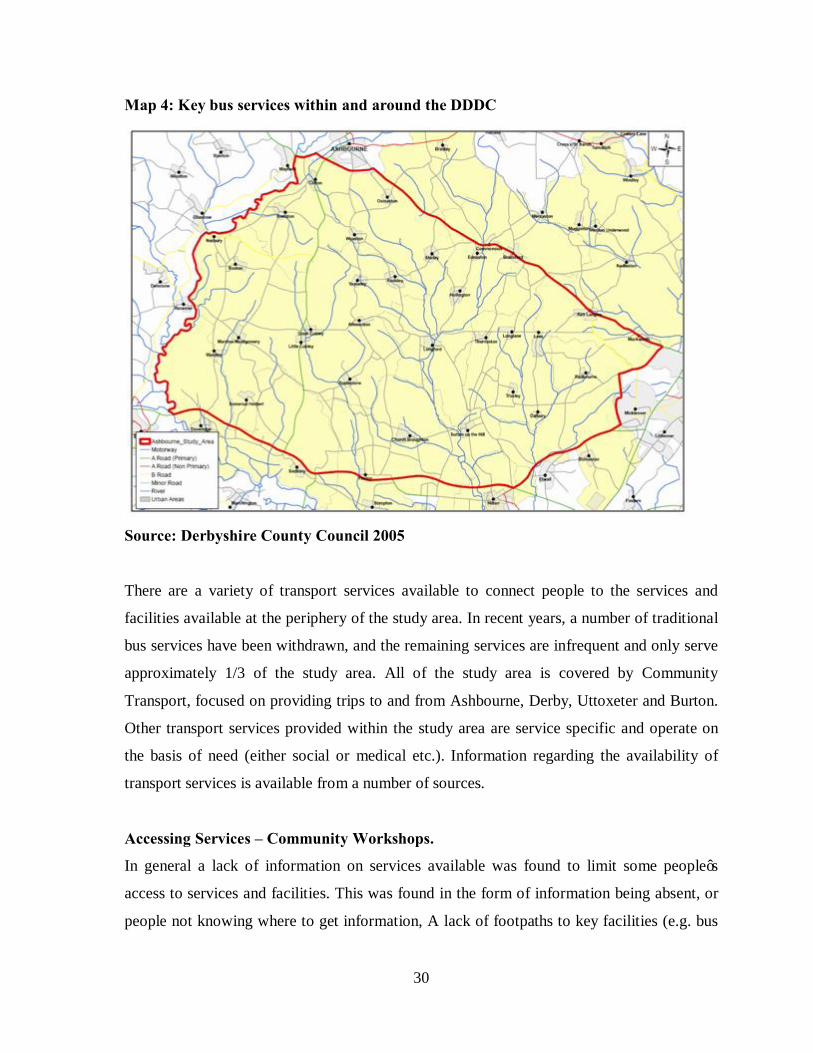
Map 4: Key bus services within and around the DDDC
Source: Derbyshire County Council 2005
There are a variety of transport services available to connect people to the services and
facilities available at the periphery of the study area. In recent years, a number of traditional
bus services have been withdrawn, and the remaining services are infrequent and only serve
approximately 1/3 of the study area. All of the study area is covered by Community
Transport, focused on providing trips to and from Ashbourne, Derby, Uttoxeter and Burton.
Other transport services provided within the study area are service specific and operate on
the basis of need (either social or medical etc.). Information regarding the availability of
transport services is available from a number of sources.
Accessing Services – Community Workshops.
In general a lack of information on services available was found to limit some people’s
access to services and facilities. This was found in the form of information being absent, or
people not knowing where to get information, A lack of footpaths to key facilities (e.g. bus
31
stops, schools, pubs etc) restricted access, particularly as walking on the carriageway is
perceived as dangerous in many places, For access to many facilities / services, the car is
perceived as the only option for travel. Car sharing does take place but is limited to informal
arrangements, “Buses don’t fit” (both destinations and travel-demand times) is a feeling
echoed by many persons as services often run only on specific days during the week,
limiting when people can travel. This increases the potential for people to rely on cars, Inter
village travel, “just doesn’t happen”, Community transport is well used but there is still
some confusion regarding the service available, Transport can be expensive (e.g. home –
hospital rides), Healthcare provision varies, with some medical facilities being mobile,
Education can usually be accessed by school bus but some parents prefer to transport
children by car. After school clubs, adult education and post 16 travel may require car use,
Delivery services are available but vary between settlements. Some services are “thought” to
exist, but not definitively known about. The internet can be useful for shopping but people
may prefer to go out to shop, Different villages have different levels of activity depending
on their character and the organization of their people, Leisure and social time can be village
oriented, but wider trips generally require car use.
Accessing Health Facilities
Suggestions received from the Community Group Participants – Access to Healthcare
A mobile health clinic would be welcomed, so long as it is available at hours that suited
residents, and meets specific needs (e.g. inoculations),
Information on access to health services to be displayed at a local focal point – e.g. Parish
council notice boards. This is seen as an important resource, Also display community
transport information to ensure people are fully aware of services available, Transport
options should be made cheaper.
Accessing Education Facilities.
General Education: Participants felt that using public transport created a time
inconvenience with regards accessing education.
In many locations, it was noted that children cannot walk to school owing to the lack of
footpaths, speed of cars, narrow lanes and the problems with travel if they are running late.
32
Apart from the draw of the Sixth Form in Ashbourne, some children travel into
Staffordshire.
Access to Shops.
If local services are to be sustained then there needs to be regular transport links to
Ashbourne, Mobile shops would be considered for use assuming that the price and quality of
products were suitable, The new radio station for Ashbourne could be used to advertise local
services and facilities,
Community transport needs to be better promoted and more extensive in the service offered.
Access to Leisure & Social Facilities
Demand responsive transport to services may be a good idea. E.g. to facilities at Ashbourne,
Small scale facilities brought into villages, Etwall area – lots of clubs and would like people
to attend – maybe advertise more widely, Provide a footway to the football field in
Longford.
2.4 Conceptual framework of the Project.
In the realization and provision of a plan for the improvement of accessibility in Kabula
Location, the Development project seeks to take a number of measures in terms of time
frame and implementation. The project is perceived to develop the location by improving
the accessibility and the transport system. This will entail the reconstruction and
maintenance/ repair of roads, construction of bridges and creating of the parking bay for
‘boda boda’ vehicles at Kabula market.
To achieve this, the framework has to be applied where the planning guidance and
intervention will try to approach head-on the problems and effects of the decay. The
resultant will be a major improvement in the accessibility that would lead to effective rural
development. This will go a long way in trying to reduce some of the problems such as poor
state of roads, lack of parking facility, lack of market for farm products and low income in
the location among others. This project is based on the notion that increase in accessibility
to the area attracts development. Good transport system attracts investments to a place. It is
the obligation of all stakeholders to benefit from the good accessibility to the rural area. This
will ensure sustainable growth and rural development.

33
The following figure shows the conceptual framework of the development project.
GRAPHICAL PRESENTATION OF THE CONCEPTUAL FRAMEWORK.
Figure 3: The graphical representation of conceptual framework.
Source: the Author June 2010.
34
CHAPTER THREE.
SITUATION ANALYSIS.
3.0 Introduction.
The difficulties of the task to estimate the gap between the producer and consumer,
measured not in kilometers but in terms of the cost, depends to a great extend upon the
geographical features of a region as well as upon its economic structure. Factors such as
topography, climatic conditions incomes and employment levels, human settlement patterns
among others have a significant role in determining the type of transport system in any area.
Basically this chapter deals with physiographical and social-economic conditions that
influence the use of the different modes of transport (bicycles, motorcycles and motor
vehicles) in the study area. This information is valuable in understanding the role transport
modes play in the development of Kabula Location.
3.1 Location context and area extent.
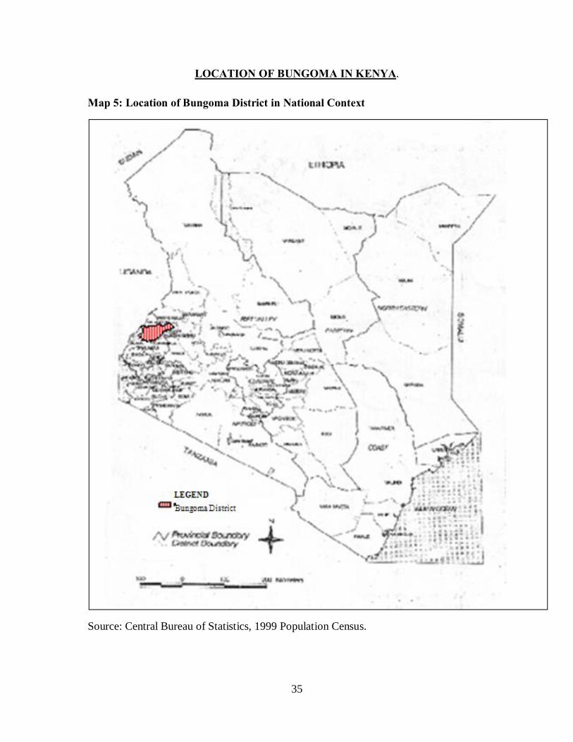
Kabula location is located in Bungoma South District which is one of the districts that make
up the Western Province of Kenya. The district was part of the larger Bungoma District until
2009 when it was created. The district borders Bungoma central to the north and to the east,
Teso district to the west, Busia District to the South West and Mumias to the south.
Kabula location is located in Bumula Division. Bumula Division is one of the 8 divisions in
Bungoma District. Others are: Sirisia, Kanduyi, Webuye, Kimilili, Tongaren and Malakisi.
Kabula market, which is centrally located in Kabula location, is located along the Mumias-
Bungoma road corridor, which is 22 km long. The road is a primary road class C. Along this
corridor is other centre; Musikoma, Sibembe, Bulimbo/Harambee, Panyakoo Mayoni and
Lukoye, in the order from Bungoma to Mumias. Kabula Market is located between Sibembe
and Bulimbo centers and is 10 km from Bungoma town.
35
LOCATION OF BUNGOMA IN KENYA.
Map 5: Location of Bungoma District in National Context
Source: Central Bureau of Statistics, 1999 Population Census.

36
Map 6: Location of Kabula in Bungoma District.
Source: Central Bureau of Statistics, 1999 Population Census
37
3.2 Background and historical context of the project area.
The word ‘Kabula’ in the local language of ‘Bukusu’ means “divide”. The location
separates the ‘Bukusu’ and the ‘Wanga’ communities of the Luhya tribe. Kabula market
is the main centre for Kabula location originally known as ‘Kambi’ that means the
“Camp to one of the early Chiefs for Bukusu called Sudi Namachanja”. The Chief used
this centre for his administrational purpose in pre-colonial periods. His territory covered
the whole of Kabula location and the other neighbouring locations like South Bukusu,
North Bukusu and Musikoma, previously known as South Bukusu Location. The
market’s name changed from Kambi to Kabula because it acted as the centre that
“separated” the Bukusu and Wanga communities.
3.3 Physical and natural environmental characteristics of the study area.
3.3.1 Topography and relief.
The location lies in an altitude ranging between 1100 to 1250 meters above sea level,
from south to the north. The rising of the altitude is affected by both the Sang’alo and
Musikoma hills, which are northward of the location. Kabula location falls within the
Lake Victoria Basin and lies at the southern part of the foothills of Mount Elgon. The
Location is also characterized by valleys and hills due to the various rivers and streams.
There are numerous streams and the undulating topography, which supports agriculture,
but also constrains the development of roads due to large numbers of bridges and culverts
required during road construction. The main rivers are Sio on the western border while
Khalaba is on the eastern border of the study area. The hilly terrain in some parts of the
Location and the sandy soils renders these areas liable to soil erosion which is significant
in road construction.
3.3.2 Geology and soils.
The rocks that form the plateau around the Location belong to the Karirondian system
which occupies not only Bungoma district but also most parts of Western Province. The
area presents an undulating plateau surface occasionally interrupted by some distinct

38
outcrops of numerous rocks pendants of the Karirondian series. Syoya hill, which is to
the western part of the Location, consists of rock and building stone whose value has
been expressed in the building industry within the larger Kabula Location. The soils are
mainly of well-drained dark red friable clays (with deep humid top soil) and dark brown
sandy loam.
3.3.3 Hydrology.
The main rivers in the Kabula location are Sio and Khalaba that flow southward towards
Lake Victoria that is several miles away. Within the Kabula location, there are several
streams that drain their waters to the two main rivers mentioned above as tributaries. The
tributaries of Khalaba River are; Wamunyiri, Saminchi and Wamumali, while the
tributaries to Sio are; Syoya, Kabula, Remwa and Talitia
3.3.4 Drainage.
Rivers and streams are the main drainage system in Kabula location. There are two main
rivers in the location, that is; Khalaba and Sio Rivers, which drains into the larger Nzoia
River. The streams like Kabula, Wamumali, Remwa, Saminchi, Malinda and Talitia
among others are tributaries to both Khalaba and Sio rivers also offer water supply to the
location for domestic use although several primary schools have boreholes for clean
water used for domestic purposes.
3.3.5 Climate.
Rainfall.
The location receives between 1250mm to 18000mm of rainfall in a year. The long rains
fall in the months of late March to late May and 25% of the rains fall during the short
rains in August to October. The dry season is from December through February. The
rainfall distribution and reliability has a contribution to the major agricultural and
livestock activities in the growing of sugar-cane, maize, millet and sorghum among
others. It supports various livestock activities in the location.
39
Temperatures.
Temperatures for the whole district are more or less homogeneous. The annual maximum
temperature ranges between the mean maximum of 220C and 300Cand the mean
minimum of 140C to 180C.It has a high mean temperature of about 230C.
The extremes of temperature and rainfall raise the real costs of transport well above what
they would be in similar conditions in average temperature and rainfall. Kabula Location
is fortunate that her climate avoids extremes of the heat and rainfall. This is due to the
predominant altitude which is 1100 meters and over above sea level, and the temperature
influences of Lake Victoria and both Sang’alo and Musikoma hills. The location is
characterized throughout the year with a cool, wet season and hot dry season, which
raises many problems of road maintenance. In the heat of the dry season, gravel surfaced
roads become dusty and corrugated. When the rains begin such roads are in the worst
possible rutted state. Drainage is generally bad, so that roads on which dust has been the
main problem rapidly become muddy tracks in heavy rain.
Humidity.
The location has a mean humidity of 70. At over 1200 m above sea level, the location
falls within the humid climate (LM3 agro-ecological zone).
3.3.6 Vegetation.
The study area has simple vegetation characteristics including a number of tree types,
grasses and other perennial shrubs. Various vegetation covers ranging from bush land to
woodland and grassland are found in Kabula location. The areas with dense agricultural
activities have planted vegetation of trees like blue gum, cypress and eucalyptus among
others. The original vegetation has been cleared through many years of cultivation and
settlement. The location is characterized with grassland vegetation; Elephant grass, star
grass and Cymbopogon are occasionally found.

40
3.3.7 Agro-Ecological Zones.
The southern part of Bungoma District is a high potential sugarcane growing zone,
though it is similarly a maize growing area too. Kabula Location lies in this part of the
district where maize and sugarcane have been grown in the region for a long time.
Sugarcane n has been grown since 1978 when Mumias Sugar Company started its
operation. Maize is the prominent food crop in Bungoma District, while sugarcane has
been the most prominent cash crop in the District. Other major crops grown in the
Location are millet, cassava, sweet potatoes, vegetables, groundnuts and beans.
Sugarcane is the only cash crop grown in the Location because of the good soil and its
proximity to Mumias Sugar Co.
The study area lies under zone I of the Agricultural Land Potential in Kenya. This zone
has well drained fertile soils, more than 1015mm rain per annum. This zone represents
land of high agricultural potential and occupies 5.5% (31,110 sq. km) of the land area in
Kenya (Human Settlement in Kenya, 1978).
3.4 Population and demographic characteristics.
Kabula location has an estimated population of 70,000 people (2009). The majority of the
people in the area live in their rural homes, which accounts for more than 95% of the
population. The urban centers accommodate some urban residents. Kabula market is the
main centre that accommodates over 500 people while other centers like Malinda,
Sibembe and Watoya accommodating an average of 100 persons per center. The large
Bumula division had a population density of 374 (1999) and 425 (2002). It was projected
to increase to 551 by the year 2008 as by the Bungoma District Development Plan 2005-
2008. The average household size of Kabula location is six persons. This gives the total
households to be almost 11, 667. The infant mortality rate is 78/100 while the life
expectancy is at 60 years. Below is a map showing the population distribution in the
Location.
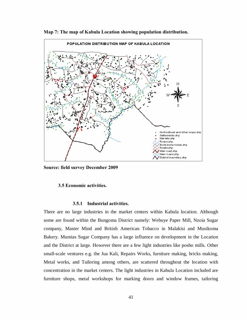
41
Map 7: The map of Kabula Location showing population distribution.
Source: field survey December 2009
3.5 Economic activities.
3.5.1 Industrial activities.
There are no large industries in the market centers within Kabula location. Although
some are found within the Bungoma District namely: Webuye Paper Mill, Nzoia Sugar
company, Master Mind and British American Tobacco in Malakisi and Musikoma
Bakery. Mumias Sugar Company has a large influence on development in the Location
and the District at large. However there are a few light industries like posho mills. Other
small-scale ventures e.g. the Jua Kali, Repairs Works, furniture making, bricks making,
Metal works, and Tailoring among others, are scattered throughout the location with
concentration in the market centers. The light industries in Kabula Location included are
furniture shops, metal workshops for marking doors and window frames, tailoring
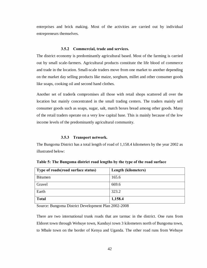
42
enterprises and brick making. Most of the activities are carried out by individual
entrepreneurs themselves.
3.5.2 Commercial, trade and services.
The district economy is predominantly agricultural based. Most of the farming is carried
out by small scale-farmers. Agricultural products constitute the life blood of commerce
and trade in the location. Small-scale traders move from one market to another depending
on the market day selling products like maize, sorghum, millet and other consumer goods
like soaps, cooking oil and second hand clothes.
Another set of trader’s compromises all those with retail shops scattered all over the
location but mainly concentrated in the small trading centers. The traders mainly sell
consumer goods such as soaps, sugar, salt, match boxes bread among other goods. Many
of the retail traders operate on a very low capital base. This is mainly because of the low
income levels of the predominantly agricultural community.
3.5.3 Transport network.
The Bungoma District has a total length of road of 1,158.4 kilometers by the year 2002 as
illustrated below:
Table 5: The Bungoma district road lengths by the type of the road surface
Type of roads(road surface status) Length (kilometers)
Bitumen 165.6
Gravel 669.6
Earth 323.2
Total 1,158.4
Source: Bungoma District Development Plan 2002-2008
There are two international trunk roads that are tarmac in the district. One runs from
Eldoret town through Webuye town, Kanduyi town 3 kilometers north of Bungoma town,
to Mbale town on the border of Kenya and Uganda. The other road runs from Webuye

43
town to Kamukuywa toward Kitale Town to Southern Sudan through Lodwar town. The
national classified roads constituted over 6,3575 km by the year 2007.
3.6 Level of education.
The study was carried out on the ‘boda boda’ operation in the location. The operators of
‘boda boda’ in Kabula location are people who have good education. They have attained
at least the upper primary, which enables the operators to understand, and some can
communicate in English. Most of them have attained secondary school level of education
with 38%. The other group attained upper primary school education at 30%. From this
finding, because of the low levels of education to the ‘boda boda’ operators, the resultant
opportunity open for employment are in the informal sector which is both ‘boda boda’
business and farming. These businesses need well developed road networks to provide
accessibility to the rural production and settlement areas.
3.7 Land uses in Kabula location.
Plate 1: Crop farming and commercial activities in Kabula Location.
Source: field survey February 2010
Kabula location is characterized by the farming of Maize, beans, groundnut, sweet
potatoes, tomatoes and cassava. The main cash crop in this region is the sugarcane. The
area lies in the sugar belt region of both Mumias and Nzoia Sugar Companies. The
44
location serves both companies with Mumias Sugar Company taking the larger share.
The larger part of land in Kabula location is grown with sugarcane, an average of five
acres per household is rendered for sugarcane plantation.
There is also livestock farming. Livestock kept are the indigenous cattle, grade cattle,
sheep, goat, pigs and not to forget the delegacy of poultry especially local chickens
though some households have Layers poultry.
The other land uses in the study area are the commercial centers. Kabula market has
higher hierarchy than centers like Watoya and Sibembe. Kabula market is a rural market
while other centers of Watoya on the south and Sibembe in the north are local centers.
These centers lie along the Mumias-Bungoma highway with Sibembe being nearer to
Bungoma town. Kabula market can accommodate urban residents of over 200 while
Sibembe market has 100 residents. Other centers fall in the interior rural hinterland
served with all weather roads. They only offer commercial services to the hinterland
though Malinda market currently accommodates less than fifty urban residents. All the
markets are located next to primary schools with Kabula being located next to Kabula
Secondary School and a Youth Polytechnic and the large Kabula Catholic Church. Most
of the Pentecostal churches are located within the urban centers due to accessibility and
centrality with Kabula location having most of them.
The land uses and the economic activities within Kabula location are major contributors
to the developments in ‘boda boda’ business. The following can demonstrate how there is
need for both bicycle and motorcycle ‘boda boda’ services in Kabula location.
The distance between different centers and the distance from Bungoma town is so long
that walking or other common private transport system failed to serve the people.
3.8 Institutional framework of the project.
3.8.1 The role of the central government in the rural transport.
The long-standing government programmes include the improvement of roads and public
transport in the country with strong emphasis to the rural areas. The setting up of
45
different authorities e.g. the Kenya Rural Roads Authority (KERRA) has decentralized
the roles played by central government on rural transport. The government has initiated
an effort to plan comprehensively for increasing the accessibility to rural areas so that the
untapped resources would be accessed.
3.8.2 The role of the Local Authority in rural transport.
The local authority can initiate the preparation of both regional and local development
plans in consultation with the Director of Physical Planning. When the decision to
prepare the plan has originated from the local authority, the Director will need to be
furnished with such details as the purpose of the plan, objectives and scope of the plan
and information as to whether the plan is to be prepared by the Director, local authority
themselves or commissioned registered Physical planner.
The major role of the authorities is the implementing the proposals of plans and ensuring
that the requirements therein are complied with. Under the local government Act and
public health Act, the local authorities have wide-ranging powers to control and guide
development in their areas of jurisdiction. In addition, local authorities use various by-
laws to control a wide range of activities. The new physical Planning Act (1996) gives
legal authority to the local authority in the implementation of physical planning proposals
and decisions. According to the act, each local authority shall have the power to:
a. Prohibit or control the use and development of land and building in the interest of
proper and orderly development of its area.
b. Prohibit the subdivision of land or existing plats into small area.
c. Consider and approve all developments applications and grant development
permissions
d. Ensure the proper execution and implementation of approved physical development
plans.
e. Formulate by-laws to regulate zoning in respect of use and destiny of development.
The area under study falls under the jurisdiction of County Council of Bungoma. It
performs all the above-mentioned functions including the regulation of parking facility at
Kabula market and the rural access roads which are pertinent to this Development Project

46
3.8.3 The role of private sector and Non-governmental organization.
The private sector includes Non-governmental organization that are keen in providing for
financial support, technical expertise and also training programmes to the community
members in the provision and the maintenance of the infrastructure facilities to be
provided. Therefore the involvement and the participation of the various stakeholders in
the attainance of the project may be summarized as fellows;
Figure 4:Different stakeholders with their roles in the development project
Source: the Development Project author 2010.

47
Table 6: Role of Stakeholders in roads development under Bungoma District.
Stakeholder Role
Department of public works. Maintains roads, controls axle load
Local Authorities
Maintains roads under their jurisdiction;
Maintains sewerage systems.
Kenya roads board Prioritizes and budgets for roads maintenance Source: Bungoma District Development Plan 2002
Projected situation in Kabula location.
In future, if Kabula location will be left as it is today and if there will be no planning
interventions either to mitigate the problems facing accessibility in the location. The
current scenario shows that if the challenges described are not controlled for instance,
potholes on the roads, narrow roads, lack of bridges and footbridges, lack of parking at
the market among others. The transport system will continue to deteriorate where the less
accessed rural areas will be cut out from the rest of the location. There will be dark areas
in the location basing on the accessibility. The potholes on the roads will result into
muddy sections of the road and the roads rendered impassible especially during the rainy
periods. The farm products in the remote rural areas services by the bad roads will not
reach the targeted market hence the spoiling of the products. The supply of farm inputs to
the farms in the rural areas will be reduced through the higher costs of transport. Some
people will be unable to accesses essential services like education, health, and recreation
and information due disconnection by the roads. The current disorder at the bus stop at
Kabula market will grow worse. There will be struggle for parking space between the
modes of transport, the traditional pubic transport modes of matatus, buses and taxis will
be competing with the growing number ‘boda boda’ modes of both bicycles and
motorcycles.

48
Map 8: Map of the future projection for nil interventions.
Source; Author July 2010
49
3.8.4 Summary of the emerging issues in Kabula Location.
a. There are numerous streams and two rivers in Kabula Location. The streams and
rivers have been a constraint in the connectivity of road networks between the
villages within the location. There is lack of bridges and footbridges across these
rivers to connect the villages.
b. During the heavy rainy seasons, some parts of most roads are flooded with water,
with the dark brown sandy loams soils, the roads surfaces usually turns muddy
therefore hindering transport hindered motorized transport.
c. The location produces several farm produces like maize, sweet potatoes, beans,
groundnuts and sugarcane among others which needs transport from and out of the
remote rural areas. The rural areas are also supplied with farm inputs from the
markets.
d. There are several markets and urban centres, which interconnect with each other.
Kabula market is the highest in the hierarchy and the other service centres depends on
Kabula market.
e. There is only one tarmac road, which runs form Mumias to Bungoma towns. Other
than this road, the other road that is classified within Kabula Location is the one that
runs from Kabula Market to Sang’alo Market through Wamunyiri local centre.
f. The population growth rate of 3.7% shows a high population when projected in
future, therefore the location needs development for the projected population.
g. There have been developments in the ‘boda boda’ business where the motorcycles are
replacing the bicycles. This has led to more problems in the industry especially on
parking and accessing rural areas.
50
CHAPTER FOUR.
PROJECT PLANNING, DESIGN AND IMPLEMENTATION.
4.0 Introduction
This chapter looks at the development process of the improvement of accessibility and
the suggested changes in each stage of design. This will include the outputs and outcomes
of the project, the development of detailed action plans and implementation strategies
that will entail the actors and implementation Agencies.
According to the part V of the Physical Planning Act cap 286 of 1996, it is the role of the
Local authorities’ to implement development plans within their area of jurisdiction. It is
therefore the responsibility of the County Council of Bungoma to implement the
development project. The developers and the residents are expected to comply with
development control policies. The residents are expected to offer technical skills, advice
and financial resources towards realization of access in Kabula Location and market as
well as develop a sense of ownership of the improved accessibility.
4.1 Expected outputs and outcomes of the Development Projects.
This project is expected to suggest and recommend a short-term to long-term
improvement of accessibility in Kabula Location. The plan will seek to upgrade the some
of the existing rural roads from Minor roads to secondary roads and Special Purposes
roads to Minor roads together with creating a bus and bicycle parking facility at Kabula
market. This development project is expected to have the following outcomes.
i. The improvements and upgrading of the roads from the Special Purposes and
minor roads to minor roads and secondary roads respectively.
ii. The expansion of the road reserves for all the minor roads, special purposes
roads and the secondary roads.
iii. The creation of more special purposes roads in the area, which are well
constructed to facilitate access to major facilities by the people in the area.
51
The current Special Purpose Roads have troubled the motor vehicles and
‘boda boda’ services hence accessibility to the facilities.
iv. The creation of bridges and footbridges across the main rivers and streams
within Kabula Location to increase accessibility across the rivers and streams.
v. The parking facility for the ‘boda boda’ modes of transport next to the bus
stop to facilitate the exchange of modes to the motorized modes at Kabula
market.
vi. Intergrades the parking facility with the traditional public transport system of
matatu, buses and taxis at Kabula Market.
vii. Provision of other services at the parking facilities like hotel rest room and
carrier services.
viii. Creation of taxing system at the parking facility to the motor vehicle and
‘boda boda’ operators.
ix. There will be more classified roads in the Kabula location to facilitate more
allocation of resources and more planning for the roads.
x. There will be extension and opening up of new roads to connect the areas
where there are active production and settlement activities yet they had lacked
road connections.
4.2 Development of a spatial plan
4.2.1 Design of alternatives
The development of spatial plans is very important in the development program. This will
lead to the consideration of the current challenges facing accessibility in Kabula
Location. Therefore, the plan will focus on addressing the ways for mitigating these
challenges. The spatial plans will go further to establish other programmes that would
assist in the improvement of rural accessibility in the location and make the road
transport system efficient. The plan also ought to address the deficiency in roads and
transport linkages within the location. While developing the spatial plans, several
alternatives will be devised and analyzed critically. These will guide the development of
a good accessibility through the road system in the preferred plan.
52
4.2.2 Alternative plan proposals.
There are various alternative plans for the purpose of improvement of accessibility in
Kabula location through the roads system. The alternatives will aim at establishing the
best proposal that will fit the Kabula Location. These alternative plans include:
a. Alternative 1: Improving the accessibility through extension of the road
system and parking facility.
In this alternative, various challenges and problems facing accessibility in Kabula
location will be mitigated. Problems like the poor road conditions; lack of roads
connections in some areas in the location; few classified roads; narrow roads; lack of
parking at Kabula market and lack of footbridges and bridges among others, will be
mitigated through this alternative. The desired or ideal accessibility network for a rural
area and Kabula location in particular can be achieved only through addressing the above
problems. This will create a good road system that is efficient in the servicing the rural
areas. There will be the upgrading of the roads through reconstruction and repair of some
roads; construction of new roads, footpaths, special purpose roads and minor roads;
upgrading of class of some road from special purpose roads to minor road or secondary
roads, minor roads to secondary roads; construction of a parking facility at Kabula market
and construction of both bridges along river Khalaba and river Sio and footbridges along
the rivers and some of the streams. The roads which run from Mukhuma Primary School
to Mateka through Remwa and Syoya Local centres and the one which run from Kabula
market to Sang’alo through Wamunyiri local centre will be upgraded to secondary roads.
The special purposes roads to be upgraded to minor roads are the roads which run from
Kabula market to Syoya local centre, from Kabula market to Talitia Local centre, from
Kabula market Remwa local centre and from Kabula market to Wamumali Village. The
other special purposes road which runs from Sibembe to Namwacha through Mwiruti and
Malinda will be upgraded to secondary road. The bridges along rivers Khalaba and Sio
will be constructed on all the classified roads, that is, the secondary roads, minor roads
and special purposes roads. The footbridges will be constructed along the footpaths and
other unclassified roads where they cross the rivers or the streams. There will be the
reconstruction of some roads through resurfacing for attain all weather roads. The roads
53
to be reconstructed are; road from Kabula to Wamumali local centre, form Kabula market
to Remwa local centre, Kabula to Talitia local centre and Sibembe to Naburereya local
centre. This will lead to an improved the accessibility in the location. There will be
expansion of the road widths and road reserves with the creation of more special purposes
roads to facilitate transportation of sugarcane and maize from the farms to the factories
and the supply of farm inputs like manure, fertilizer, seeds and mechanization during the
farming process.
At the market centre, there will be a well serviced parking facility for the exchange of
modes of travel as an entry and exit for the location. This therefore means that their will
be improved access to essential goods and services at a cheaper cost by the people as the
transportation will have been streamlined.
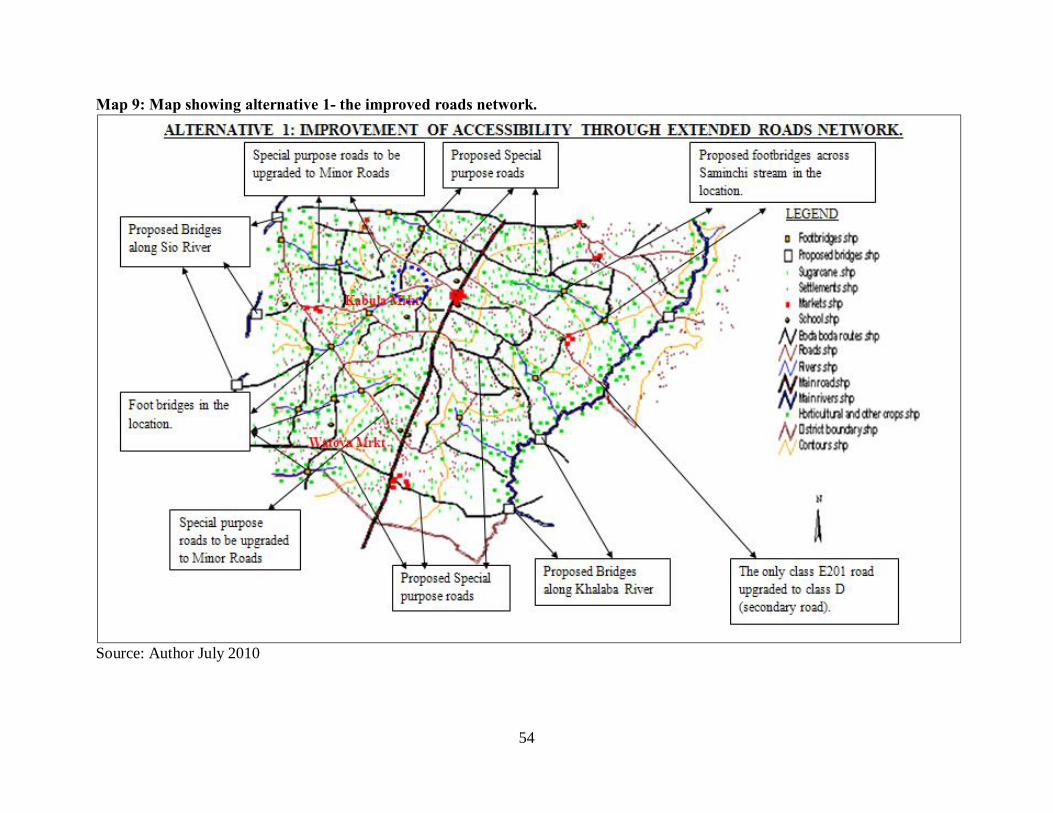
54
Map 9: Map showing alternative 1- the improved roads network.
Source: Author July 2010
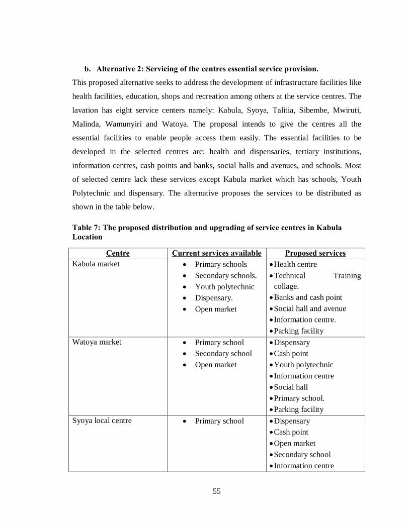
55
b. Alternative 2: Servicing of the centres essential service provision.
This proposed alternative seeks to address the development of infrastructure facilities like
health facilities, education, shops and recreation among others at the service centres. The
lavation has eight service centers namely: Kabula, Syoya, Talitia, Sibembe, Mwiruti,
Malinda, Wamunyiri and Watoya. The proposal intends to give the centres all the
essential facilities to enable people access them easily. The essential facilities to be
developed in the selected centres are; health and dispensaries, tertiary institutions,
information centres, cash points and banks, social halls and avenues, and schools. Most
of selected centre lack these services except Kabula market which has schools, Youth
Polytechnic and dispensary. The alternative proposes the services to be distributed as
shown in the table below.
Table 7: The proposed distribution and upgrading of service centres in Kabula Location
Centre Current services available Proposed services Kabula market • Primary schools
• Secondary schools. • Youth polytechnic • Dispensary. • Open market
• Health centre • Technical Training
collage. • Banks and cash point • Social hall and avenue • Information centre. • Parking facility
Watoya market • Primary school • Secondary school • Open market
• Dispensary • Cash point • Youth polytechnic • Information centre • Social hall • Primary school. • Parking facility
Syoya local centre • Primary school • Dispensary • Cash point • Open market • Secondary school • Information centre
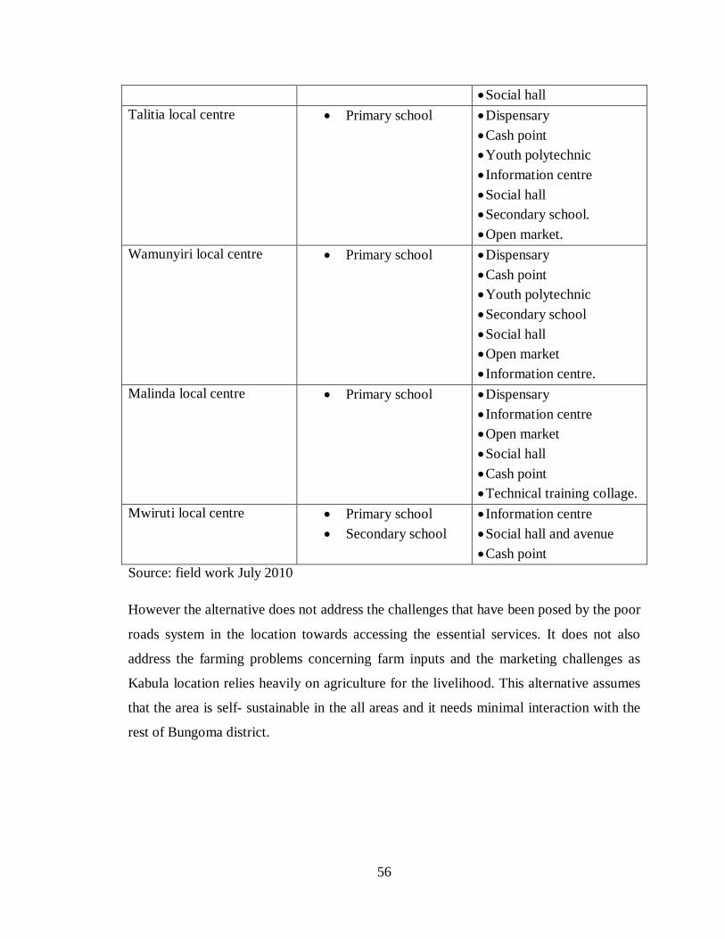
56
• Social hall Talitia local centre • Primary school • Dispensary
• Cash point • Youth polytechnic • Information centre • Social hall • Secondary school. • Open market.
Wamunyiri local centre • Primary school • Dispensary • Cash point • Youth polytechnic • Secondary school • Social hall • Open market • Information centre.
Malinda local centre • Primary school • Dispensary • Information centre • Open market • Social hall • Cash point • Technical training collage.
Mwiruti local centre • Primary school • Secondary school
• Information centre • Social hall and avenue • Cash point
Source: field work July 2010
However the alternative does not address the challenges that have been posed by the poor
roads system in the location towards accessing the essential services. It does not also
address the farming problems concerning farm inputs and the marketing challenges as
Kabula location relies heavily on agriculture for the livelihood. This alternative assumes
that the area is self- sustainable in the all areas and it needs minimal interaction with the
rest of Bungoma district.

57
Map 10: Map showing Alternative 2 - upgrading of centres.
Source: Author July 2010
58
4.2.3 Evaluation of alternatives and the Preferred plan.
The first alternative where the area will be left without any planning interventions will
cost the developers anything. However this plan will lead for more damages on the
development of the location. The Location will develop area without access through the
decay of the roads which will hinder the transport modes to access. Other effects like
poor parking system will create disorder at Kabula market bus stops where currently most
of the ‘boda boda’ operators do park their motorcycles and bicycles. The lack of road
connections to area of productivity and settlement will discourage investors and settlers
to invest or settle in such areas within the location. Therefore the alternative does not
promote development in the location.
The second alternative addresses the improvement of access in Kabula location through
the roads network. Through the reconstruction of the roads, upgrading of the roads, the
increasing of classified roads, construction of bridges and footbridges and the
construction of a parking facility at Kabula market, will lead to improved access to
remote rural areas and efficient transport system. This alternative will lead to effective
flow of goods and persons from the rural to the market or urban centres, therefore
encouraging the development of Kabula Location.
The third alternative addresses the servicing of the main centres in the Location through
provision of services that ought to be missing. The provision of services like information
centres, social halls and avenue, tertiary institutions, cash points and banks, open
markets, health and dispensaries and schools in these centres would provide essential
services near the people for accessibility. However the alternative does not address the
transport problems and challenges that have led to poor access to these services.
Therefore the alternative can only lead to development in Kabula Location if it is
developed after the second alternative.
The preferred plan will use proposals from the second alternative to come up with a good
improvement in the accessibility through roads system in Kabula location. In the
preferred plan, improvement of existing accessibility through roads and parking facilities

59
will be done. The plan will also address the problem of few classified roads through
upgrading and creating more roads.
4.3 Site planning and evaluation.
Here we are going to have a broad overview of the existing situation in Kabula Location.
It will involve a critical analysis of primary and secondary data, re-confirmation of site
inventory, overlying of site characteristics as well as site potentials, challenges and
opportunities. The main issues to be looked at includes the existing transport means, the
accessibility in the area, the land uses and identification of critical site planning potentials
and challenges for Kabula market. The analysis will form the guide to the development of
proposals and inform any policy as well as planning interventions that will be put in place
for improving the accessibility in Kabula location.
4.4 Critical site planning challenges and opportunities.
4.4.1 Opportunities.
Open spaces.
There are many open spaces at Kabula market that can be used for a parking facility at
the market for the location. The open spaces are located along the Mumias- Bungoma
Highway. There are two open spaces between the shops, which are right opposite each
other. One is next to the bus stop from Mumias Town, while the other is between the
main road and the open market. There is an open space that can also be developed for
parking right after the shops next to the Mosque.

60
Figure 5: sketch map showing open spaces at Kabula Market
Source: field survey February 2010. The first open space next to the bus stop from Mumias town has nothing in it. This open
space is partly owner by the County Council of Bungoma and the private developer at
Kabula market. The space is free from buildings though sometimes it is used for parking
of tracks and temporally vehicle servicing. The space has been used for open crusades
and public rallies at some point. When the parking facility is constructed here, the public
rallies will be conducted at the space next to the open market on the opposite side of the
main road.
The second open space located next to the open market is currently used for temporal
shopping stalls. It also has a footpath though large enough for tracks to use when
accessing property in the market and is an illegal route. The land on which this space is
located is under the custody of the County Council of Bungoma. The space is appropriate
for putting up of the parking facility as it is located next to the main road, it centrally in
the market centre, and the ownership.
The third open space, which is located next to the mosque, is currently used for urban
agriculture. The land though has flooding during rainy season because of the valley and

61
the low altitude compared with the rest of the market centre. The space also lies at the
fringe of the market centre therefore, it would create imbalance in transport if the parking
facility would be created on it where the loading and offloading zones will be far off the
market, shops and the bus stops.
Access roads.
Kabula location has several roads that are fairly distributed. There are both minor roads
and special purposes roads that serve the location. The special purposes roads were
created to facilitate transportation of sugarcanes from the farm to the main road (Mumias
-Bungoma road) which leads to Nzoia and Mumias sugar factories.
Gentle slope.
Kabula Location has a gentle slope, which ranges from the 1100 to 1250 meters above
the sea level. The gentle slope in the location makes the construction of roads and other
facilities easy.
Farm products.
Bungoma district largely depend on agriculture and farm products for their livelihood.
Agricultural products accounts to over 60% of the people source of income in the district.
Kabula Location carries out several farming practices including both livestock and crop
farming. The available livestock are cattle, poultry, goat, pigs and sheep, while the crops
grown are maize, beans, groundnuts vegetables, potatoes, and millets among others.
These farming practices yield products where the surpluses are sold at the markets to
generate income.
Primary road (tarmac)
Kabula Location is connected to the rest of Bungoma district through a primary road. The
primary road of class C33 runs from Mumias to Bungoma towns. This road is tarmac
with the road width including the road reserves of between 30 to 50 meters.

62
Map 11: Map 9: Map of the analysis of Kabula Location
Source; Author July 2010
63
4.4.2 Challenges
1. The poor status of the roads, which are sometimes impassible during the rainy
seasons. This hinders the accessibility of remote rural area when using the
motorcycles.
2. Increased accidents in the transport industry that involve the pedestrians,
motorcycles alone or with others, motor vehicles and bicycle operators. Four of
every 5 motorcycle operators have been involved in accidents. Though the extend
of the accidents are just minor injuries but the households’ information shows that
some have lead to disables and major injuries.
3. There is much of interference with the operation of the traditional modes of public
transport of buses, taxis and matatu where the motorcycles would park at the bus
station, or they use same lanes with the buses. This also has led to traffic pileups
and creates bottlenecks.
4. The crime levels in transport sector has increased with goods being stolen,
motorcycles been stolen and killing being reported. Poor driving skills by the
motorcycles operators who are not well trained. This has led to increased
accidents and crimes.
5. Poverty, lack of employment and greed for more than one can afford, have
contributed to the rise of crime cases in the ‘boda boda’ and transportation as a
whole.
6. There is increased pollution of both air and sound in the remote rural area and the
social division in the service provision between the motorcycle operators and the
bicycle operators due to bride among the motorist.
7. Kabula location is an agricultural zone, the transportation of the farm produce
from the farm to the market of to the homes are a challenge to the comfort of the
‘boda boda’. The farm produce are dirty which for the cleanliness of the transport.
8. Lack of parking and exchange spaces for the integration of motorcycles to with
the rest of traditional public transport at Kabula market.
64
9. Bad behaviors by the transport operators who drive the vehicles while drunk.
They end up mishandling their customers and create negative altitude towards the
‘boda boda’ operators and the business at large.
10. The training school of motorcycles are very far which has led to the youths to
seek easier ways of training from unqualified trainers.
4.5 Detailed design formulation sections and action plans.
The Development Project will entail two sections to achieve the desired goal of the
improvement of the rural accessibility in Kabula location.
ü Section one: The improvements of the roads networks.
This will involve both the upgrading of the minor roads and the Special Purpose roads to
the secondary roads and minor roads respectively. This section will also address the
classification of roads, the construction of new roads and footpaths, the construction of
bridges and footbridges and increasing the road classes through creating more secondary
roads. The program will also develop the roads conditions through repairs and
reconstructions in Kabula location.
In Kabula Location, most of the roads are not classified, only the tarmac road that runs
across the location from Mumias to Bungoma towns and the road running from the
Kabula market to Sang’alo market through Wamunyiri local centre.
The following all weather roads will be upgraded from unclassified and Special Purposes
Roads to secondary road. These roads will be expanded in their width, the road surfaces
will be charged from the current earth, and gravel to murram road.
§ The roads proposed program.
There are several roads that have been proposed in this Development Project that will be
changed to achieve the desired states of accessibility in Kabula Location. the table below
indicates the roads with the current class and the proposed action.
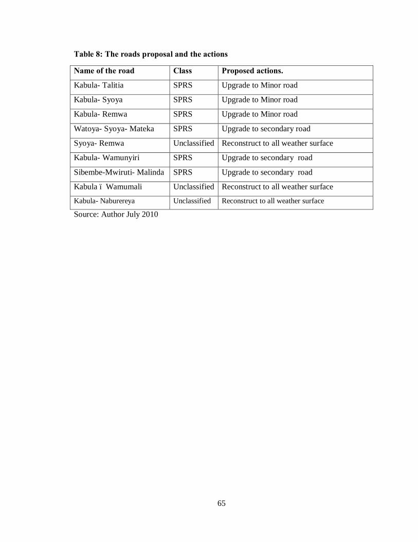
65
Table 8: The roads proposal and the actions
Name of the road Class Proposed actions.
Kabula- Talitia SPRS Upgrade to Minor road
Kabula- Syoya SPRS Upgrade to Minor road
Kabula- Remwa SPRS Upgrade to Minor road
Watoya- Syoya- Mateka SPRS Upgrade to secondary road
Syoya- Remwa Unclassified Reconstruct to all weather surface
Kabula- Wamunyiri SPRS Upgrade to secondary road
Sibembe-Mwiruti- Malinda SPRS Upgrade to secondary road
Kabula – Wamumali Unclassified Reconstruct to all weather surface
Kabula- Naburereya Unclassified Reconstruct to all weather surface
Source: Author July 2010

66
§ DEVELOPMENT OF SPATIAL PLAN.
Map 12: Map of Kabula Location showing roads and service centres
Source: Author July 2010
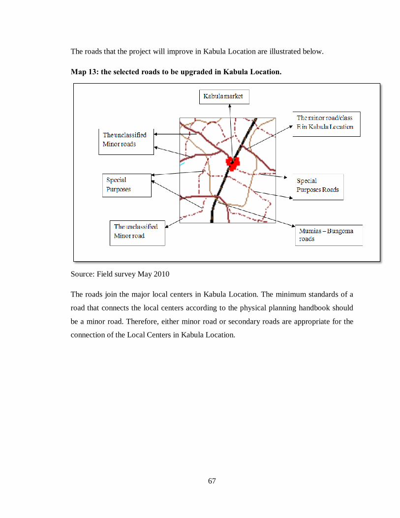
67
The roads that the project will improve in Kabula Location are illustrated below.
Map 13: the selected roads to be upgraded in Kabula Location.
Source: Field survey May 2010
The roads join the major local centers in Kabula Location. The minimum standards of a
road that connects the local centers according to the physical planning handbook should
be a minor road. Therefore, either minor road or secondary roads are appropriate for the
connection of the Local Centers in Kabula Location.
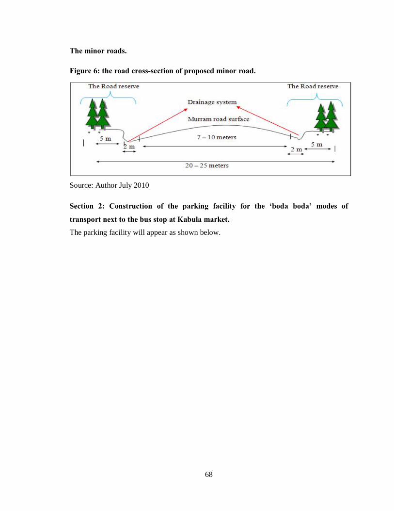
68
The minor roads.
Figure 6: the road cross-section of proposed minor road.
Source: Author July 2010 Section 2: Construction of the parking facility for the ‘boda boda’ modes of
transport next to the bus stop at Kabula market.
The parking facility will appear as shown below.

69
Figure 7: The plan of Parking Facility at Kabula market
Source: Author July 2010

70
This program will be for the construction of a parking facility at Kabula market. The
parking facility will be located along the Mumias – Bungoma road on the left side of the
road. This will be between the open market and the Tarmac road and between the stage
from Bungoma and the shops retail shops. The parking plan will appear as shown in the
figure above.
Plate 2: The elevations of the proposed parking facility
Source: Author July 2010
4.6 Implementation strategies. The implementation ought to address the problems that have led to the need to plan. The
problems addressed in this project are the few classified roads; the remote rural has less
accessibility; poor road conditions; lack of parking facility and lack of bridges and
footbridges in the location. In addressing the objectives of all this problems, there will
strategies to enhance the achievements of the objectives. Furthermore, programmes have
been derived to monitor the strategies with there cost and time or period that each
program is estimated to take.
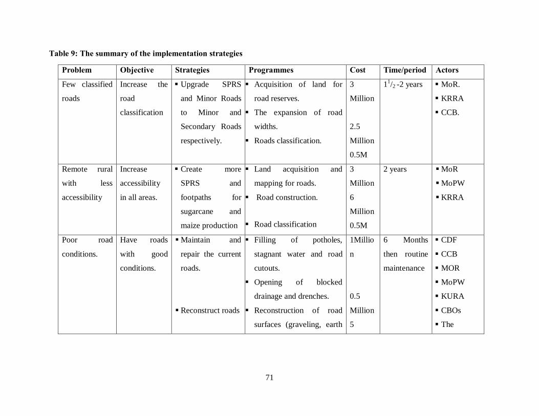
71
Table 9: The summary of the implementation strategies
Problem Objective Strategies Programmes Cost Time/period Actors
Few classified
roads
Increase the
road
classification
§ Upgrade SPRS
and Minor Roads
to Minor and
Secondary Roads
respectively.
§ Acquisition of land for
road reserves.
§ The expansion of road
widths.
§ Roads classification.
3
Million
2.5
Million
0.5M
11/2 -2 years § MoR.
§ KRRA
§ CCB.
Remote rural
with less
accessibility
Increase
accessibility
in all areas.
§ Create more
SPRS and
footpaths for
sugarcane and
maize production
§ Land acquisition and
mapping for roads.
§ Road construction.
§ Road classification
3
Million
6
Million
0.5M
2 years § MoR
§ MoPW
§ KRRA
Poor road
conditions.
Have roads
with good
conditions.
§ Maintain and
repair the current
roads.
§ Reconstruct roads
§ Filling of potholes,
stagnant water and road
cutouts.
§ Opening of blocked
drainage and drenches.
§ Reconstruction of road
surfaces (graveling, earth
1Millio
n
0.5
Million
5
6 Months
then routine
maintenance
§ CDF
§ CCB
§ MOR
§ MoPW
§ KURA
§ CBOs
§ The

72
surface and murram). Million community
Lack of
parking space
Provide for
parking space.
Construct parking
facility.
§ Kabula market parking
facility construction.
2
Million
6 Months § CCB.
§ Private
developer.
Lack of
bridges and
footbridges.
Provide for
bridges and
footbridges
across river.
Construct bridges
and footbridges.
Construction of bridges
Construction of footbridges
5
Million
0.2
million
1Year
§ CCB
§ CDF
§ KRRA
§ MoPW
Source: field survey May 2010

73
4.6.1 Implementations schedule.
a) First stage- policy stage.
This stage will involve the formulation of the policies framework for the implementation
of the project. During the stage the implementation body or committee would be formed,
while all the stakeholders are brought on board. There will be the clarification of the roles
for all the stakeholders and the setting of goals and objectives for all the stakeholders.
The necessary resources will be sourced and brought in for the implementation. The stage
also seeks to foresee all the challenges and problems, and put up measures that would
help to overcome the challenges. This stage also seeks to legalize the development
project by seeking the approvals from all the concerned authorities through preparation of
all documents needed. The main authorities here are the central government through the
Kenya Rural Roads Authority and the County Council of Bungoma.
b) Second stage- construction and upgrading the roads.
This stage is the initial physical development process of the development project. During
the stage, all the tendering of the construction works would take place and the
constructors commence their tasks. There will be reconstruction of the roads to achieve
the desired standards, the road surfaces will be changed accordingly and the roads width
being expanded. Apart from the road reconstruction, new roads would also be constructed
and the construction of bridges across the major rivers and streams. There will be the
construction of footpaths and footbridges across the streams to increase the accessibility.
Finally, the stage would involve the classification of roads by increasing the classified
roads in the location and upgrading the current minor roads into secondary roads and the
special purposes roads into minor road then creating more special purposes roads. The
stakeholders involved are the private sector who will be tendered to carry out the
construction and reconstruction works, the community who will offer both skilled and
unskilled labour in the implementation; the central government will be involved through
the ministry of roads in the roads classification.

74
c) Third stage- construction of parking facility.
The third stage would involve mainly construction of a parking facility with initially
tendering of the program before the construction. The stage will mainly focus on the
second section of the project where the parking facility at Kabula market is involved.
d) Fourth stage- administration of the parking service.
This stage will involve the legal frameworks that would govern the use of the parking
facility. The stage would involve the generation of the by-laws by the CCB for the
parking at Kabula market.
4.6.2 Implementation schedule- Period, phasing, costing and resource
requirements.
4.6.2.1 Implementation strategies
These are the steps toward achieving the ideal and desired goals and objectives of this
development Project for the improvement of accessibility of Kabula location through
roads networks. For this to be achieved there shall be need to reflect on the key emerging
issues in Kabula location.
§ Background of the problems and challenges.
§ Obtaining effective transport system in Kabula location to increase accessibility.
§ Create efficient avenue for exchange of different modes of transport at Kabula
market.
§ Obtaining good connectivity between different villages in the remote rural areas
and across the rivers and streams.
§ Obtain good road conditions and increase road classes in Kabula location.
§ Poverty and little investments in Kabula location due to poor accessibility.
75
4.6.2.2 The cost of implementing the project.
The implementation of this Development project will incur a variety of resources that
will be necessary during the implementation, operation and maintenance. These resources
include the following:
• Financial resources
Financial resources are the major resources for any project to be implemented. These
resources will be used in the acquisition of land for road and road reserves and
compensation of the private property that would be affected during the implementation of
this project. The resources will also be used to meet the costs of roads construction and
reconstruction, the cost of construction of parking facility, the cost of new bridges and
footbridges, cost of community labour, and cost of road classification and land mapping.
The sources of these resources will be from the Central Government through the Ministry
of Roads, Ministry of Public Works and the Kenya Rural Roads Authority. Other sources
include:
• Human resources.
The human resources are in terms of human workforce and technological knowledge that
will be utilized in the supervision, management, construction of roads, bridges,
footbridges, and parking facility, maintenance of roads, parking facility and drainage
system Kabula Location. The resource providers will involve the Kabula Location
community, private developers, government employees and the County Council of
Bungoma Employees.
• Physical resource.
The main physical resource in the implementation of this Development Project is land.
Land is need for the expansion of the roads widths, the construction of new roads and
footpaths, construction of parking facility and the bridges. The land resources will be
acquired from the private land and the County Council of Bungoma. There will be need
for relocation of private land and the people to other area for the implementation of this
development project.
76
4.6.3 The role of actors/implementing agencies.
§ Central government responsibilities
The central government is the supreme authority in the implementation of the
Development project. There are several roles that the central government will play:
i. Financing the project through the Kenya Roads Board, Kenya Rural Roads
Authority, the Ministry of Roads and Ministry of Public Works.
ii. To initiate partnership with the development partners for financing and
implementation of the project.
iii. Tendering out of the project for the implementation through.
iv. Preparation and approval of development plan through the Ministry of Lands.
The central government will oversee the whole process so that all stakeholders participate
effectively in the implementation of the project.
§ Local government responsibilities
The local government plays a grater role in the life of the markets centres and the people
served by those centers. Having the authority to implement the regulations concerning the
growth and stability of a centre, cannot be overlooked when preparing a parking facility
for the market centre. The law through the physical planning act Cap 286 and the local
authorities act Cap 265 of the laws of Kenya mandates the County council of Bungoma to
approve all development plans within the area of their jurisdiction. The parking facility
proposed at Kabula market is on the county council land at which will need its approval.
The county council is also mandated to make by-laws that will govern the operations of
this parking faculty. The rural roads maintenance would be partly through the Local
Authority Transfer Funds that are dispersed through the area councilors from the
Counties. Therefore, the county council of Bungoma will play the role of financing part
of this project.

77
• Community responsibilities.
The community will be involved in the implementation of the project with several
responsibilities among them are:
1. The surrendering of the land for the expansion and construction works involved in
the project.
2. Participation in the construction through provision of human labour.
3. Management of the roads and parking facility through ownership.
4. The community is the main beneficiaries of the project; therefore they will be
involved in the evaluation of the success in the development of the project.
78
CHAPTER FIVE.
MONITORING AND EVALUATION OF THE PROJECTS.
5.0 Introduction
Monitoring and evaluation of the project will be carried out at specific time intervals during the
implementation and operational stages of the project. It is proposed that an evaluation and
monitoring board or committee should be created immediately at the start of the project
implementation. The committee will consist of the representatives from the CCB, participating
NGOs, CDF, Central government private firms and community. Representatives from the central
government will be the chairperson of the committee as the central government is the supreme
authority in the area and would bring harmony in the implementation of this project. Through
consultations, the committee will monitor;
ü All environmental issues in the Location with a view to making an assessment of any
changes in the environment through the road constructions.
ü The operation of all the participant undertaking the ongoing process of road
constructions, maintenance and repairs, drainage system, bridges and parking facility.
ü All social-cultural and economic issues in the location that the progress of the project will
impose to the people and mitigate them.
The committee will also evaluate the project to determine:
The levels at which the implementation projects and programmes are achieving the previously
set goal and objectives of the project.
5.1 Monitoring and evaluation stage of the implementation of the project.
The stage spells out the achievements and the failures in the progress of the development project
towards achieving the set goals and objectives.

79
5.2 Indicators of the progress of the project.
There will be visible indicators of the progress of this project through active participation and
monitoring by the transport and accessibility seekers in the Location. This will be seen through
the efficient transport system. There will be accessibility to the remote rural areas through all
weather roads. This will attract more participants in the transport sector within Kabula location.
There will be increased employment of the people in the transport sector in Kabula location.
Investors will be attracted to invest in different sectors of economy within the Kabula location
because there will be opened room through increased accessibility. There will be market for
farm products and easy access to farm inputs by the farmers in the location. The increased
facility will create room for the exchange of goods and services within and with the outside of
the location. This will increase trade of the goods and services. There will also lead to increased
revenue for the county council due where there will be charges for parking and the access to the
parking facility. Finally there will be economic growth for Kabula location residents leading to
poverty reduction.
5.2.1 Guidelines for the implementation process
The implementation stages of this development project should be a participatory process of the
development, CCB, Kabula Community, visitors in the name of investors and other interested
development agencies. The participatory process will create the identity and ownership of the
project by the community, the authorities and developers. The Kabula Location accessibility
project should have a well functioning partnership as an implementation guideline at all stages.
The Kabula Location accessibility project management committee should work in solidarity to
see the realization of the improved accessibility in Kabula location.
The issues related in the project implementation guidelines include:
5.2.2 Participation guidelines.
These will involve implementation of the already formulated sectoral partnership plan. The roles
of all the stakeholders will be set according to the capacity of the stakeholders and they will be
expected to meet the specific standards in their participation against which their will be

80
monitored and evaluated. They will be checked through regular cross sectoral meetings of all
stakeholders to update of the project implementation.
5.2.3 Sustainable parking facility.
The parking will be maintained by the CCB. The CCB will legislate by-laws that will govern the
parking facility and put in place the management board for the daily running of the parking
facility. Through the board, the members of the community who will have a representative in the
board will participate in the running of the facility.
The parking fee will be used for the maintenance of the parking through repairs and renovation
and meeting the wages of workers in the facility.
5.2.4 Guideline to rural roads and accessibility.
The rural areas especially the remote rural have been developed ready for the accessibility. There
are some guidelines that the people should observe for the accessibility. The specially purposes
roads have been constructed for accessing the sugarcane farms, maize farms and other large scale
farms that uses mechanization during the production process. The drainage system along these
roads in the rural will enhance irrigation in the farms next to the roads and would be maintained
by the people being serviced by the roads. These roads will be maintained by Sugar Companies
serviced by the roads.
The minor roads and secondary roads that collect traffic from the special purpose roads connects
the rural areas to urban centres or connects the service centers in the Location. The roads will be
maintained by the CDF, LATF and KERRA bodies in the location.
5.3 Site / Environment Management plan.
To ensure that this project proceeds with minimum disruption of the physical environment, an
environmental management plan was prepared. The main objectives are:
a. Feasible and cost effective measure to prevent or reduce significant negative impacts of
the development to acceptable levels.
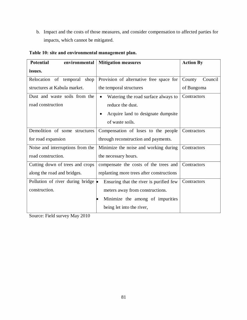
81
b. Impact and the costs of those measures, and consider compensation to affected parties for
impacts, which cannot be mitigated.
Table 10: site and environmental management plan.
Potential environmental
issues.
Mitigation measures Action By
Relocation of temporal shop
structures at Kabula market.
Provision of alternative free space for
the temporal structures
County Council
of Bungoma
Dust and waste soils from the
road construction
• Watering the road surface always to
reduce the dust.
• Acquire land to designate dumpsite
of waste soils.
Contractors
Demolition of some structures
for road expansion
Compensation of loses to the people
through reconstruction and payments.
Contractors
Noise and interruptions from the
road construction.
Minimize the noise and working during
the necessary hours.
Contractors
Cutting down of trees and crops
along the road and bridges.
compensate the costs of the trees and
replanting more trees after constructions
Contractors
Pollution of river during bridge
construction.
• Ensuring that the river is purified few
meters away from constructions.
• Minimize the among of impurities
being let into the river,
Contractors
Source: Field survey May 2010
82
5.4 Conclusion
With the general improvement of accessibility through roads system, the problem related to rural
accessibility will be solved. The improvement of road system will ensure that the less accessed
rural areas are easily reached. The classifications of the roads will hell in the stratified allocation
of the funds for road maintenance by the government and will also hell in the planning for the
road networks through the road standards in the location.
The creating of a parking facility at Kabula market will not only provide entry point for revenue
collection to the CCB but will also streamline the exchange in modes transport at Kabula market.
This will also generate goods connectivity of Kabula location with the rest of Bungoma district
through the Mumias –Bungoma highway.
This project recommends that there should be integration of all stakeholders in the improvement
of accessibility in Kabula location of this essential service for the rural residents.
83
REFERENCES AND BIBLIOGRAPHY.
1. Republic of Kenya Physical Planning Handbook 2005, Government printer,
Nairobi, Kenya.
2. Republic of Kenya, Bungoma District Development Plan 2002-2008, Government
printer, Nairobi, Kenya.
3. Republic of Kenya, National Development Plan 1969-1970, Government printer,
Nairobi, Kenya.
4. Republic of Kenya, National Development Plan 1970-1974, Government printer,
Nairobi, Kenya.
5. Republic of Kenya, National Development Plan 1974-1978, Government printer,
Nairobi, Kenya.
6. Republic of Kenya, National Development Plan, Part I 1979-1983, Government
printer, Nairobi, Kenya.
7. Republic of Kenya, National Development Plan Part II, 1979-1983, Government
printer, Nairobi, Kenya.
8. Republic of Kenya, National Development Plan 1984-1988, Government printer,
Nairobi, Kenya.
9. Republic of Kenya, National Development Plan 1989-1993, Government printer,
Nairobi, Kenya.
10. Republic of Kenya, National Development Plan 1994-1996, Government printer,
Nairobi, Kenya.
11. Republic of Kenya, National Development Plan 1997-2001, Government printer,
Nairobi, Kenya.
12. Republic of Kenya, Public Roads and Roads of Access Act (1970). Cap 399.
Government printer, Nairobi, Kenya.
13. Republic of Kenya, Traffic Act, Cap 403 (1993). Government printer, Nairobi,
Kenya.
14. Republic of Kenya, Physical Planning Act, Cap 286 (1996). Government printer,
Nairobi, Kenya.

84
15. Republic of Kenya, Environmental Management and Coordination Act (1999),
Government printer, Nairobi, Kenya.
16. Republic of Kenya, Kenya Roads Board Act. (1999), Government printer, Nairobi,
Kenya.
17. Republic of Kenya, Integrated National Transport Policy, “Moving a Working
Nation, Ministry of Transport and Communications,” (2004). Government printer,
Nairobi, Kenya.
18. Republic of Kenya, Economic Recovery Strategy for Wealth and Employment
Creation. (2007). Government printer, Nairobi, Kenya.
19. Republic of Kenya, Kenya Roads Bill (2007), Government printer, Nairobi, Kenya.
20. Republic of Kenya, Local Government Act, Cap 265(1986), Government printer,
Nairobi, Kenya.
21. Republic of Kenya (1978). Human settlement of Kenya “purple book”
22. Republic of Kenya, Road Design Guidelines for Urban Roads, 2001). Government
Printer, Nairobi, Kenya.
23. Kevin Smith, Ashbourne Rural Accessibility Study, 2009. “Base conditions,
Barriers and options for improving Rural access’, Dimple Road, Derbyshire.
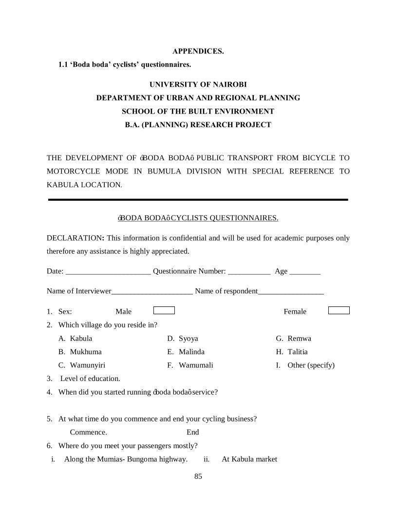
85
APPENDICES.
1.1 ‘Boda boda’ cyclists’ questionnaires.
UNIVERSITY OF NAIROBI
DEPARTMENT OF URBAN AND REGIONAL PLANNING
SCHOOL OF THE BUILT ENVIRONMENT
B.A. (PLANNING) RESEARCH PROJECT
THE DEVELOPMENT OF ‘BODA BODA’ PUBLIC TRANSPORT FROM BICYCLE TO
MOTORCYCLE MODE IN BUMULA DIVISION WITH SPECIAL REFERENCE TO
KABULA LOCATION.
‘BODA BODA’ CYCLISTS QUESTIONNAIRES.
DECLARATION: This information is confidential and will be used for academic purposes only
therefore any assistance is highly appreciated.
Date: ______________________ Questionnaire Number: ___________ Age ________
Name of Interviewer_____________________ Name of respondent_________________
1. Sex: Male Female
2. Which village do you reside in?
A. Kabula
B. Mukhuma
C. Wamunyiri
D. Syoya
E. Malinda
F. Wamumali
G. Remwa
H. Talitia
I. Other (specify)
3. Level of education.
4. When did you started running ‘boda boda’ service?
5. At what time do you commence and end your cycling business?
Commence. End
6. Where do you meet your passengers mostly?
i. Along the Mumias- Bungoma highway. ii. At Kabula market

86
iii. At home
iv. At other markets
v. Along other roads.
7. Where do you pack your bicycle while waiting for passengers?
a. Along the road reserve
b. Along the bus terminus
c. Along the shop premises
d. Along the mechanics premises
e. Others (specify)
8. What are you daily earning in your bicycle ‘boda boda’ business?
Highest. Lowest
9. What reasons made you to start run bicycle ‘boda boda’ business?
i. …………………………………………………………………………………..
ii. …………………………………………………………………………………..
10. What challenges, problems or limitations do you face in the running of bicycle ‘boda boda’
business?
i. …………………………………………………………………………………
ii. …………………………………………………………………………………
iii. …………………………………………………………………………………
iv. …………………………………………………………………………………
11. How have you managed to overcome the above challenges?
a. ……………………………………………………………………………………….
b. ……………………………………………………………………………………….
c. ……………………………………………………………………………………….
12. When was your first time to encounter with the motorcycles ‘boda boda’?
13. In your opinion what has led to transition in ‘boda boda’ from bicycles to motorcycles
i. ………………………………………………………………………
ii. ………………………………………………………………………
iii. ………………………………………………………………………
14. What changes have motorcycles brought in the ‘boda boda’ business?
a) …………………………………………………………………………….
b) ……………………………………………………………………………….
c) ………………………………………………………………………………
87
d) ……………..………………………………………………………………..
15. How have motorcyclist managed the challenges above?
a. ……………………………………………………………………………………..
b. …………………………………………………………………………………….
c. …………………………………………………………………………………….
16. Give the reasons and any recommendations to cope with the following challenges
motorcycles pose to you as a cyclist.
Challenges Reasons Recommendations.
Competition.
Accidents
Pollution of air
and sound
Crime
Others
(specify)
17. Which improvements did motorcycles bring in ‘boda boda’ public transport service?
i. …………………………………………………………………………………………
ii. …………………………………………………………………………………………
iii. …………………………………………………………………………………………
18. What are the ways and means of improving both the bicycle and motorcycle ‘boda boda’ as a
mode public transport?
i. ……………………………………………………………………………………………
ii. …………………………………………………………………………………………
iii. ……………………………………………………………………………………………
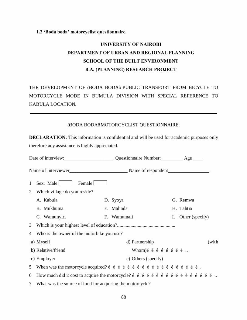
88
1.2 ‘Boda boda’ motorcyclist questionnaire.
UNIVERSITY OF NAIROBI
DEPARTMENT OF URBAN AND REGIONAL PLANNING
SCHOOL OF THE BUILT ENVIRONMENT
B.A. (PLANNING) RESEARCH PROJECT
THE DEVELOPMENT OF ‘BODA BODA’ PUBLIC TRANSPORT FROM BICYCLE TO
MOTORCYCLE MODE IN BUMULA DIVISION WITH SPECIAL REFERENCE TO
KABULA LOCATION.
‘BODA BODA’ MOTORCYCLIST QUESTIONNAIRE.
DECLARATION: This information is confidential and will be used for academic purposes only
therefore any assistance is highly appreciated.
Date of interview:____________________ Questionnaire Number:_________ Age ____
Name of Interviewer________________________ Name of respondent_________________
1 Sex: Male Female
2 Which village do you reside?
A. Kabula
B. Mukhuma
C. Wamunyiri
D. Syoya
E. Malinda
F. Wamumali
G. Remwa
H. Talitia
I. Other (specify)
3 Which is your highest level of education?................................................
4 Who is the owner of the motorbike you use?
a) Myself
b) Relative/friend
c) Employer
d) Partnership (with
Whom)……………………..
e) Others (specify)
5 When was the motorcycle acquired? ………………………………………………….
6 How much did it cost to acquire the motorcycle? ……………………………………………..
7 What was the source of fund for acquiring the motorcycle?

89
a. Owner savings
b. Borrowed
c. Bank loans
d. C.B.O.
e. Donations
8 When did you start the ‘boda boda’ business? ..........................................................................
9 Before you joined ‘boda boda’, motorcycle what was your occupation?
1) ‘Boda boda’ cyclist.
2) Famer.
3) No occupation.
4) Commercial business.
5) Student.
6) Others (specify).
10 What reasons made you start to run motorcycle ‘boda boda’ business?
i. …………………………………………………………………………………..
ii. …………………………………………………………………………………..
iii. …………………………………………………………………………………
11 Where do you pack your bicycle while waiting for passengers?
i. Besides the shops.
ii. At the bus terminus
iii. Beside the Mumias- Bungoma road.
iv. Besides the mechanics premises.
12 Where do you meet your customers mostly?
a. Along the Mumias- Bungoma highway.
b. At Kabula market.
c. At home.
d. At other markets.
e. Along other roads.
13 What are you daily earning in your motorcycle ‘boda boda’ business?
Highest. Lowest
14 What are the challenges, problems or limitations have you faced in running the ‘boda boda’
business?
i. ……………………………….......................................................................................
ii. ……………………………………………………………………………………
iii. ………………………………………………………………………………………
15 How have you managed to overcome the above challenges?
a. ………………………………………………………………………………………….
b.………………………………………………………………………………………….
c. ………………………………………………………………………………………….

90
16 Which improvements did motorcycles bring in ‘boda boda’ public transport service?
a. …………………………………………………………………………………………
b.…………………………………………………………………………………………
c. ………………………………………………………………………………………
17 How far do you driver your motorcycle (kilometers) in a day?
18 At what time do you commence and end driving your motorcycle?
Commence. End
19 What are the requirements for one to drive the motorcycle?
i. …………………………………………………………………………………..
ii. …………………………………………………………………………………
iii. …………………………………………………………………………………
20 Do you have any document for identity as motorcycle driver?
21 If yes which one(s)?
i. …………………………….
ii. …………………………….
iii. …………………………
iv. …………………………
22 What advantages do motorcycles have over bicycles in offering ‘boda boda’ service?
a) ………………………………………………………………………………
b) ………………………………………………………………………………
c) ……………………………………………………………………………..
23 Which traffic rules are most broken by motorcyclists?
a. ………………………………………………………………………………………
b. ………………………………………………………………………………………
24 Give the reasons and any recommendations to cope with the following challenges faced
Challenges Reasons Recommendations.
Competition.
Accidents.
91
Pollution of air
and sound.
Poor roads.
Crime.
Others (specify).
25 Have you been involved in motorcycle accident?
Yes No
26 If yes who was the other party in the accident?
i. Alone
ii. Another motorcyclist
iii. ‘Boda boda’ bicyclist
iv. Motor vehicle
v. Pedestrian
vi. Other(s) specify
27 How severe was the accident?
i. Minor injuries
ii. Deaths/ Major injury
iii. Other(s) specify
28 In your opinion what can be done to adopt motorcycles as a mode of public transport?
i. …………………………………………………………………………………
ii. …………………………………………………………………………………
iii. ………………………………………………………………………………
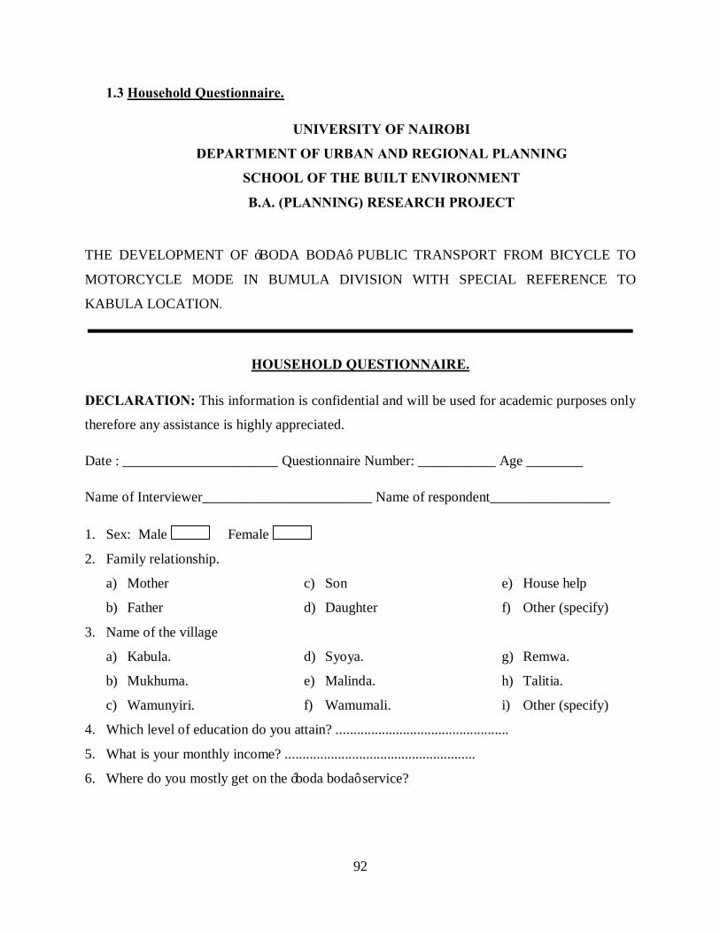
92
1.3 Household Questionnaire.
UNIVERSITY OF NAIROBI
DEPARTMENT OF URBAN AND REGIONAL PLANNING
SCHOOL OF THE BUILT ENVIRONMENT
B.A. (PLANNING) RESEARCH PROJECT
THE DEVELOPMENT OF ‘BODA BODA’ PUBLIC TRANSPORT FROM BICYCLE TO
MOTORCYCLE MODE IN BUMULA DIVISION WITH SPECIAL REFERENCE TO
KABULA LOCATION.
HOUSEHOLD QUESTIONNAIRE.
DECLARATION: This information is confidential and will be used for academic purposes only
therefore any assistance is highly appreciated.
Date : ______________________ Questionnaire Number: ___________ Age ________
Name of Interviewer________________________ Name of respondent_________________
1. Sex: Male Female
2. Family relationship.
a) Mother
b) Father
c) Son
d) Daughter
e) House help
f) Other (specify)
3. Name of the village
a) Kabula.
b) Mukhuma.
c) Wamunyiri.
d) Syoya.
e) Malinda.
f) Wamumali.
g) Remwa.
h) Talitia.
i) Other (specify)
4. Which level of education do you attain? .................................................
5. What is your monthly income? ......................................................
6. Where do you mostly get on the ‘boda boda’ service?

93
7. What are the challenges, problems and limitations you face in using the bicycle ‘boda
boda’ for public transport?
i. ………………………………………………………………………………………
ii. ………………………………………………………………………………………
8. What led to the transition of ‘boda boda’ from bicycle to motorcycle?
a. ……………………………………………………………………………………….
b. …………………………………………………………………………………….
c. …………………………………………………………………………………….
9. What are the advantages of motorcycles over other of public transport?
i. ………………………………………………………………………………………
ii. ………………………………………………………………………………………
10. What problems have the motorcycle ‘boda boda’ created in public transport?
a. ………………………………………………………………………………………
b. ………………………………………………………………………………………
11. What was the reason for boarding the ‘boda boda’?
i. ………………………………………………………………………………………
ii. ………………………………………………………………………………………
12. How much do you pay for using the following per kilometer?
Motorcycle ‘boda boda’ ……………….. Bicycle ‘boda boda’………………………
13. Compare the motorcycle with other modes of public transport in terms of:
Parameter/Other
modes
Buses, Matatus and
Taxis
Bicycles Pedestrians
Speed
Safety
Frequency
Cost
14. What effects do the motorcycles transports have to the following sectors?
Sectors Effects Recommendations
Infrastructure
94
Motor vehicle
Cyclist
Pedestrians
15. Which traffic rules are occasionally broken by motorcyclists?
a. ………………………………………………………………………
b. ………………………………………………………………………
c. ………………………………………………………………………
16. Have you been involved in motorcycle accident?
Yes No
17. What was the severity of the accident?
a. Minor injuries
b. Deaths
c. Major injury
18. In your opinion what can be done to adopt motorcycles as a mode of public transport?
i. ……………………………………………………………………………………..
………………………………………………………


