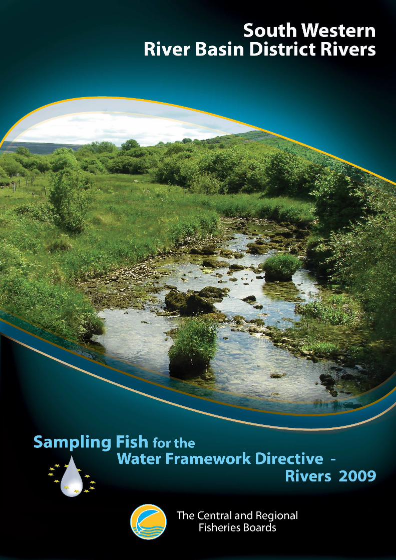
The Central and Regional Fisheries Boards
1


The Central and Regional Fisheries Boards
1
ACKNOWLEDGEMENTS
The authors wish to gratefully acknowledge the help and co-operation of the CEO Mr. Aidan Barry,
Assistant CEO Dr. Patrick Buck and the staff of the South Western Regional Fisheries Board, as well
as CEO Mr. Brian Sheerin, Assistant CEO Ms. Suzanne Campion and the staff of the Southern
Regional Fisheries Board. The authors would also like to gratefully acknowledge the help and
cooperation from all their colleagues in the Central Fisheries Board.
We would like to thank the landowners and angling clubs that granted us access to their land and
respective fisheries.
Furthermore, the authors would like to acknowledge the funding provided for the project from the
Department of Communications, Energy and Natural Resources for 2009.
PROJECT STAFF
Project Director/Senior Research officer: Dr. Fiona Kelly (PM up to November 2009)
Project Manager: Dr. Andrew Harrison (from November 2009)
Research Officer: Mrs. Lynda Connor
Research Officer: Mr. Glen Wightman (up to September 2009)
Research Officer: Dr. Ronan Matson
Technician: Ms. Grainne Hanna
Technician Mr. Rory Feeney
Technician: Ms. Emma Morrissey
Technician: Ms. Rosin O’ Callaghan
Technician: Mrs. Ciara Wogerbauer
GIS Officer: Mr. Kieran Rocks
Fisheries Assistant: Dr. Brian Hayden (Dec 2009 – Feb 2010)
Fisheries Assistant; Mr. Trevor Stafford (Dec 2009 – Feb 2010)
This report includes Ordnance Survey Ireland data reproduced under OSi Copyright Permit No. MP 007508.
Unauthorised reproduction infringes Ordnance Survey Ireland and Government of Ireland copyright.
© Ordnance Survey Ireland,2010

South Western River Basin District Rivers Report 2009
2
TABLE OF CONTENTS
1. INTRODUCTION..............................................................................................................................3
2. STUDY AREA....................................................................................................................................5
3. METHODS.........................................................................................................................................6
3. METHODS.........................................................................................................................................7
4. RESULTS ...........................................................................................................................................9
4.1 Wadeable hand-set sites ..............................................................................................................9
4.1.1 The Argideen River.................................................................................................................9
4.1.2 The River Funshion..............................................................................................................13
4.2. Boat sites....................................................................................................................................16
4.2.1 The Awbeg River (Buttevant)...............................................................................................16
4.2.2 The Bandon River.................................................................................................................19
4.2.3 The River Blackwater (Killavullen Bridge)..........................................................................22
4.2.4 The River Blackwater (Nohaval Bridge)..............................................................................26
4.2.5 The River Bride....................................................................................................................29
4.3 Community structure ................................................................................................................32
4.3.1 Species richness and composition........................................................................................32
4.3.2 Species abundance and distribution.....................................................................................33
4.3.3 Age and growth of brown trout and salmon.........................................................................45
5. DISCUSSION...................................................................................................................................47
6. REFERENCES.................................................................................................................................49
APPENDICES......................................................................................................................................51

The Central and Regional Fisheries Boards
3
1. INTRODUCTION
Fish stock surveys were undertaken in 54 river sites throughout Ireland during the summer of 2009 as
part of the programme of sampling fish for the Water Framework Directive (WFD). These surveys
are required by both national and European law, with Annex V of the WFD stipulating that rivers are
included within the monitoring programme and that the composition, abundance and age structure of
fish fauna are examined (Council of the European Communities, 2000). Seven of the 54 surveys were
carried out at river sites in the South Western River Basin District between July and early September
2009 by staff from the Central Fisheries Board (CFB), South Western Regional Fisheries Board
(SWRFB) and Southern Regional Fisheries Board (SRFB) (Table 2.1, 2.2 and Fig. 2.1). Although
fish survey work has been carried out in Ireland in the past, no project to date has been as extensive as
the current on-going monitoring programme in providing data appropriate for WFD compliance.
Continued surveying of these and additional river sites will provide a useful baseline and time-series
dataset for future monitoring of water quality. This in turn will provide information for River Basin
District managers to compile and implement programmes of measures to improve degraded water
bodies.
The fisheries service in Ireland is currently undergoing a major organisational transition. This follows
the recent government plan for the rationalisation of state agencies outlined in the 2009 budget. The
eight separate fisheries organisations, comprising the Central Fisheries Board (CFB) and seven
Regional Fisheries Boards (RFBs) are set to merge into one single entity and become Inland Fisheries
Ireland (IFI). As a result of these changes, the previous administrative zones, the RFBs, will be
realigned along the boundaries of River Basin Districts (RBDs) and will in some cases transcend
international boundaries. Previous WFD fish surveys were reported based on the seven different
RFBs; however, reporting will now reflect these new administrative changes and will group water
bodies according to River Basin Districts.
Up until 2010 the SWRFB occupied a relatively small area in the extreme south-west of the country.
The South Western River Basin District (SWRBD) covers most of this area but also includes the
Blackwater catchment in north Co. Cork, previously a part of the SRFB.
The SWRBD (Fig. 2.1) is mainly comprised of Counties Cork and Kerry, but also contains parts of
Limerick, Tipperary and Waterford. It has a total land area of 11,000km2, equating to nearly a sixth
of the entire country, along with 4,000km2 of marine waters. Expanding urban areas and agriculture
are among the greatest pressures on the region, particularly in the eastern areas, while the western half
contains some of Ireland’s most scenic and popular tourist locations. Cork City is the largest urban
area within this district and is the main centre for industry. A growing population in the region is
putting ever increasing pressure on water supplies and wastewater treatment facilities (SWRBD,
2009).

South Western River Basin District Rivers Report 2009
4
This report summarizes the main findings of the fish stock surveys in the seven river water bodies
surveyed in the SWRBD during 2009 and reports the current status of the fish stocks in each.

The Central and Regional Fisheries Boards
5
2. STUDY AREA
Seven river sites were surveyed in three river catchments within the SWRBD; the Argideen, Bandon
and Munster Blackwater catchments. The sites ranged in surface area from 405m2 for the River
Funshion to 21,840m2 for the River Blackwater at Killavullen Bridge and were divided into two
categories for reporting purposes, i.e. hand-set and boat sites.
Summary details of each site’s location and physical characteristics are given in Tables 2.1and 2.2 and
the distribution of sites throughout the SWRBD is shown in Figure 2.1.
Table 2.1. Location and codes of river sites surveyed for WFD surveillance monitoring, 2009
River Site name Catchment Site Code Waterbody code
SWRBD Hand-set sites
Argideen Ford S of Reengarrigeen Argideen IE20A020200 SW_20_2251
Funshion Brackbaun Br. Blackwater IE18F050030 SW_18_11
SWRBD Boat sites
Awbeg Kilcummer Br. Blackwater IE18A051300 SW_18_2677
Bandon Bridge near Desert Station Bandon IE20B020600 SW_20_2230_1
Blackwater Killavullen Br. Blackwater IE18B021900 SW_18_2292_5
Blackwater Nohaval Br. Blackwater IE18B020200 SW_18_450
Bride Bridge N of Ballynella Blackwater IE18B050500 SW_18_2778
Table 2.2. Details of river sites surveyed for WFD surveillance monitoring, 2009
River Upstream catchment (km2)
Wetted width (m)
Surface area (m2)
Mean depth (m)
Max depth (m)
SWRBD Hand-set sites
Argideen 1698.67 12.16 547 0.49 0.82
Funshion 16.19 9.00 405 0.22 0.35
SWRBD Boat sites
Awbeg 350.44 15.80 3792 0.46 0.80
Bandon 337.05 21.40 5543 0.57 0.80
Blackwater (Killavullen) 1256.72 40.00 21840 1.10 2.00
Blackwater (Nohaval) 89.00 11.40 2029 0.44 1.00
Bride 226.78 16.80 4754 0.46 0.70

South Western River Basin District Rivers Report 2009
6
Fig
. 2.1
. Loc
atio
n m
ap o
f riv
er s
ites
surv
eyed
throu
ghou
t the
SW
RB
D fo
r W
FD
fish
sur
veill
ance
mon
itorin
g 20
09

The Central and Regional Fisheries Boards
7
3. METHODS
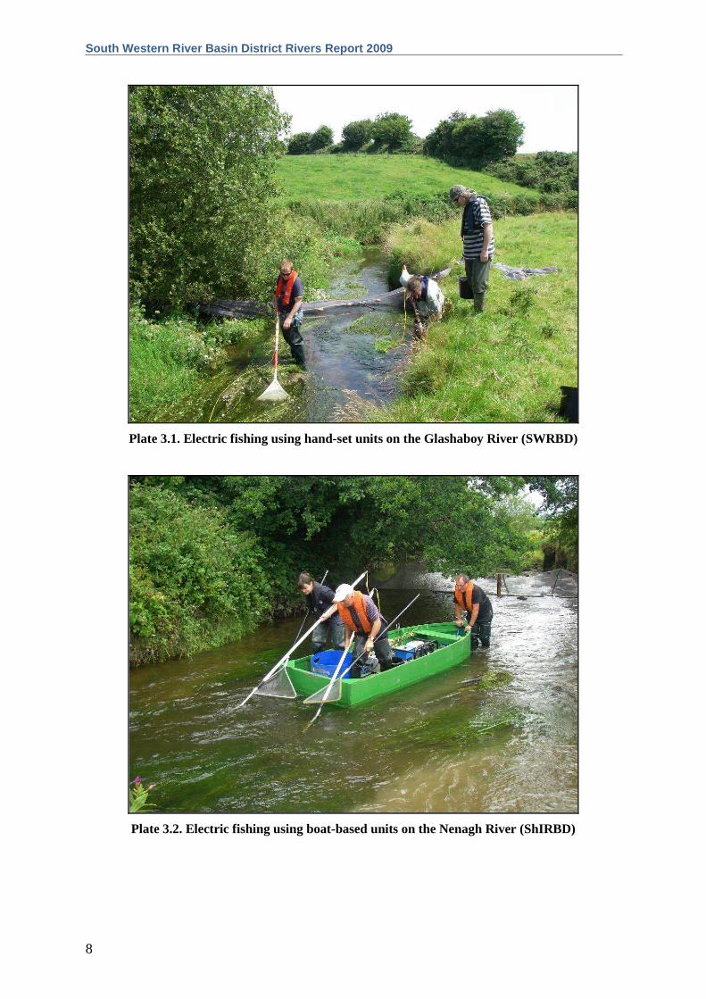
Electric-fishing (Plates 3.1 and 3.2) is the method of choice for surveillance monitoring of fish in
rivers to obtain a representative sample of the fish assemblage at each sampling site. This technique
complies with European Committee for Standardisation (CEN) guidelines for fish stock assessment in
wadeable rivers (CEN, 2003). At each site, the stretch sampled was isolated, where possible, using
stop nets, and one to three fishings were carried out using bank-based electric fishing units (hand-sets)
or boat-based electric fishing units. Each site ideally included all habitat types; riffle, glide and pool.
At each site, a number of physical habitat variables were measured. Water samples for chemical
analyses were taken, along with a multi-habitat kick-sample of macroinvertebrates. Macrophyte
surveys were carried out on selected wadeable streams.
Fish from each pass were sorted and processed separately. During processing, the species of each fish
was identified and its length and weight were measured; sub-samples were measured when large
numbers of fish were present. For the purpose of species identification, juvenile river lamprey
(Lampetra fluviatilis), brook lamprey (Lampetra planeri) and sea lamprey (Petromyzon marinus)
were recorded as ‘Lamprey sp.’. Sea trout and brown trout were listed separately. For aging
analyses, scales were taken from fish greater than 8.0cm for salmonids and most non-native fish
species. These fish were held in a large bin of oxygenated water after processing until they were fully
recovered and were then returned to the water. Opercular bones were taken from perch for ageing.
In order to draw comparisons between sites, fish densities were calculated using data from the first
fishing pass, as three fishing passes were not possible or practical at all sites. The number captured in
the first pass was divided by the total area surveyed to give a minimum population density for each
species.
A subsample of the dominant fish species were aged (five fish from each 1cm size class). Fish scales
were aged using a microfiche, and opercular bones were aged using an Olympus SZX10
microscope/digital camera system. Growth was determined by back-calculating lengths at the end of
each winter (e.g. L1 is the mean length at the end of the first winter, L2 is the mean length at the end
of the second winter, etc.).
South Western River Basin District Rivers Report 2009
8
Plate 3.1. Electric fishing using hand-set units on the Glashaboy River (SWRBD)
Plate 3.2. Electric fishing using boat-based units on the Nenagh River (ShIRBD)

The Central and Regional Fisheries Boards
9
4. RESULTS
4.1 Wadeable hand-set sites
4.1.1 The Argideen River
Plate 4.1. The Argideen River near Timoleague, Co. Cork
The Argideen River (Plate 4.1) is located in south Co. Cork. It rises in the hills north-west of
Clonakilty and flows eastwards towards Timoleague before entering the sea at Courtmacsharry
Harbour. Although salmon are present, the Argideen is best known as a sea trout fishery. When
conditions are favourable, it is believed to be among the best in Ireland, with stocks improving
steadily over the past few years (O’Reilly, 2009). The survey site, located approximately 5km north-
east of Clonakilty (Fig. 4.1), lies approximately 4.5km upstream of Courtmacsherry Estuary SAC.
Three electric-fishing passes were conducted using three bank-based electric-fishing units on the 22nd
of July 2009 along a 45m length of channel. The mean wetted width of the stretch surveyed was
12.2m and the mean depth was 49.0cm. This site was dominated by pools, with a substrate of mainly
cobble. There was a wide variety of macrophyte vegetation present at this site, including both
submerged and floating species. A total wetted area of 547m2 was surveyed.

South Western River Basin District Rivers Report 2009
10
Fig. 4.1. Location of the Argideen River surveillance monitoring site
A total of six fish species were recorded in the Argideen River site. Salmon was the most abundant
species, followed by European eel, brown trout, minnow, stone loach and three-spined stickleback
(Table 4.1).
Table 4.1. Density of fish (no./m2), Argideen River site (fish density has been calculated as minimum estimates based on the first fishing)
Species name Common name 0+ 1+ & older Total minimum
density Salmo salar Salmon 0.1499 0.0969 0.2467
Anguilla anguilla European eel - - 0.0201
Salmo trutta Brown trout 0.0073 0.0073 0.0146
Phoxinus phoxinus Minnow - - 0.0091
Barbatula barbatula Stone loach - - 0.0037
Gasterosteus aculeatus Three-spined stickleback - - 0.0018
All fish All fish - - 0.2961

The Central and Regional Fisheries Boards
11
Salmon ranged in length from 4.4cm to 13.7cm (Fig. 4.2). Three age classes (0+, 1+ and 2+) were
present, accounting for approximately 60%, 39% and 1% (one individual) of the total salmon catch
respectively. Mean salmon L1 and L2 were 4.5cm and 7.6cm respectively (Appendix 2).
European eels ranged in length from 13.4cm to 34.6cm (Fig. 4.3).
Brown trout ranged in length from 4.5cm to 21.7cm (Fig. 4.4). Three age classes (0+, 1+ and 2+)
were present, accounting for approximately 50%, 19% and 31% of the total brown trout catch
respectively. Mean brown trout L1 and L2 were 5.8cm and 15.2cm respectively (Appendix 1). This
indicates a relatively slow rate of growth for brown trout in this river site according to the
classification scheme of Kennedy and Fitzmaurice (1971).
01020304050607080
1 2 3 4 5 6 7 8 9 10 11 12 13 14 15
Length (cm)
Num
ber
of f
ish
Fig. 4.2. Length frequency distribution of salmon in the Argideen River site, July 2009 (n = 234)
0
1
2
3
4
5
1 3 5 7 9 11 13 15 17 19 21 23 25 27 29 31 33 35
Length (cm)
Num
ber
of f
ish
Fig. 4.3. Length frequency distribution of eels in the Argideen River site, July 2009 (n = 32)

South Western River Basin District Rivers Report 2009
12
0
1
2
3
4
5
1 2 3 4 5 6 7 8 9 10 11 12 13 14 15 16 17 18 19 20 21 22 23
Length (cm)
Num
ber
of f
ish
Fig. 4.4. Length frequency distribution of brown trout in the Argideen River site, July 2009 (n = 16)
The Central and Regional Fisheries Boards
13
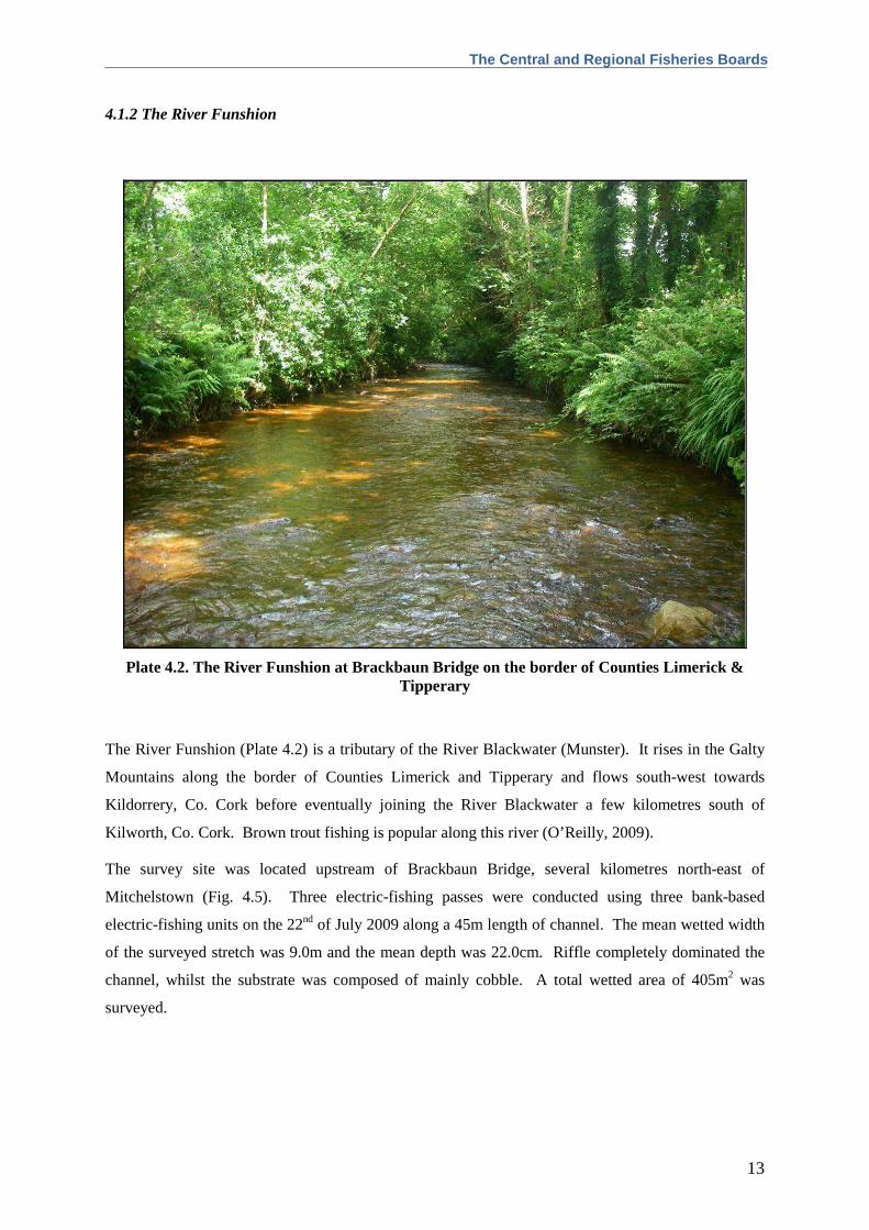
4.1.2 The River Funshion
Plate 4.2. The River Funshion at Brackbaun Bridge on the border of Counties Limerick & Tipperary
The River Funshion (Plate 4.2) is a tributary of the River Blackwater (Munster). It rises in the Galty
Mountains along the border of Counties Limerick and Tipperary and flows south-west towards
Kildorrery, Co. Cork before eventually joining the River Blackwater a few kilometres south of
Kilworth, Co. Cork. Brown trout fishing is popular along this river (O’Reilly, 2009).
The survey site was located upstream of Brackbaun Bridge, several kilometres north-east of
Mitchelstown (Fig. 4.5). Three electric-fishing passes were conducted using three bank-based
electric-fishing units on the 22nd of July 2009 along a 45m length of channel. The mean wetted width
of the surveyed stretch was 9.0m and the mean depth was 22.0cm. Riffle completely dominated the
channel, whilst the substrate was composed of mainly cobble. A total wetted area of 405m2 was
surveyed.
South Western River Basin District Rivers Report 2009
14
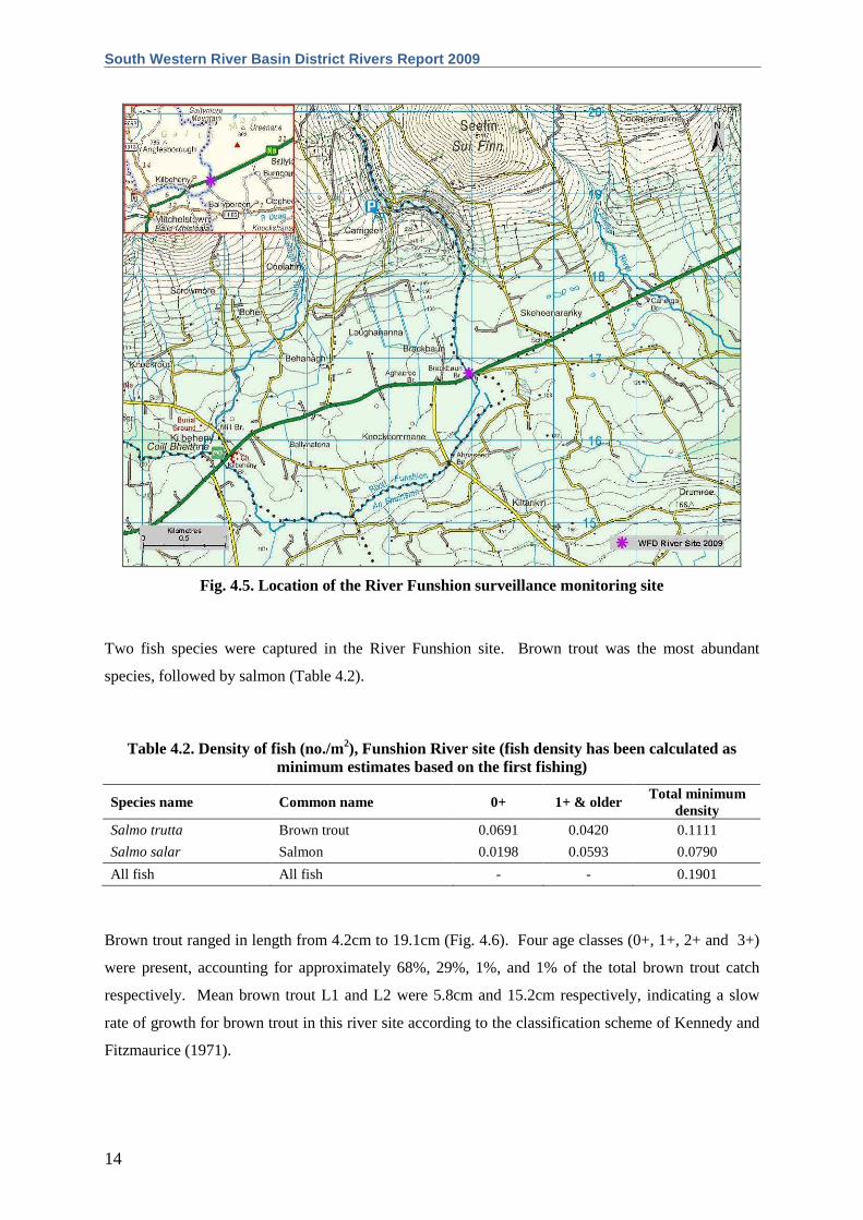
Fig. 4.5. Location of the River Funshion surveillance monitoring site
Two fish species were captured in the River Funshion site. Brown trout was the most abundant
species, followed by salmon (Table 4.2).
Table 4.2. Density of fish (no./m2), Funshion River site (fish density has been calculated as minimum estimates based on the first fishing)
Species name Common name 0+ 1+ & older Total minimum
density Salmo trutta Brown trout 0.0691 0.0420 0.1111
Salmo salar Salmon 0.0198 0.0593 0.0790
All fish All fish - - 0.1901
Brown trout ranged in length from 4.2cm to 19.1cm (Fig. 4.6). Four age classes (0+, 1+, 2+ and 3+)
were present, accounting for approximately 68%, 29%, 1%, and 1% of the total brown trout catch
respectively. Mean brown trout L1 and L2 were 5.8cm and 15.2cm respectively, indicating a slow
rate of growth for brown trout in this river site according to the classification scheme of Kennedy and
Fitzmaurice (1971).

The Central and Regional Fisheries Boards
15
Salmon ranged in length from 4.0cm to 13.5cm (Fig. 4.7). Three age classes (0+, 1+ and 2+) were
present, accounting for approximately 24%, 73% and 3% of the total salmon catch respectively.
Mean salmon L1 and L2 were 5.2cm and 10.0cm respectively (Appendix 2).
02468
10121416
0 1 2 3 4 5 6 7 8 9 10 11 12 13 14 15 16 17 18 19 20
Length (cm)
Num
ber
of f
ish
Fig. 4.6. Length frequency distribution of brown trout in the River Funshion site, July 2009 (n = 72)
0
5
10
15
20
25
30
0 1 2 3 4 5 6 7 8 9 10 11 12 13 14
Length (cm)
Num
ber
of f
ish
Fig. 4.7. Length frequency distribution of salmon in the River Funshion site, July 2009 (n = 63)

South Western River Basin District Rivers Report 2009
16
4.2. Boat sites
4.2.1 The Awbeg River (Buttevant)
Plate 4.3. The Awbeg River at Kilcummer Bridge near Castletownroche, Co. Cork
The Awbeg River (Plate 4.3) is a tributary of the River Blackwater (Munster). It rises west of the
Ballyhoura Mountains in north Co. Cork and flows in a south-eastwardly direction through Buttevant
and Doneraile, before eventually joining the River Blackwater a few kilometres south of
Castletownroche, Co. Cork. Brown trout fishing is popular along this river, although their growth
rates have been noted as slow due to relatively low average water temperatures (O’Reilly, 2009).
This site is located within the Blackwater River (Cork/Waterford) SAC, further details of which can
be found in section 4.2.3 of this report.
The survey site was located downstream of Kilcummer Bridge, approximately 0.5km north of its
confluence with the Munster Blackwater (Fig. 4.8). One electric-fishing pass was conducted using
two boat-based electric-fishing units on the 8th of July 2009 along a 240m length of channel. The
mean wetted width of the stretch surveyed was 15.8m and the mean depth was 46.0cm. The habitat
was made up entirely of riffle over a substrate of cobble and gravel, while various submerged and
emergent macrophytes were scattered throughout. A total wetted area of 3,792m2 was surveyed.

The Central and Regional Fisheries Boards
17
Fig. 4.8. Location of the Awbeg River surveillance monitoring site
A total of five fish species were recorded in the Awbeg River site. Salmon was the most abundant
species, followed by brown trout, European eel, dace and stone loach (Table 4.3).
Table 4.3. Density of fish (no./m2), Awbeg River site (fish density has been calculated as minimum estimates based on the first fishing)
Species name Common name 0+ 1+ & older Total minimum
density Salmo salar Salmon 0.0024 0.0208 0.0232
Salmo trutta Brown trout - 0.0116 0.0116
Anguilla anguilla European eel - - 0.0018
Leuciscus leuciscus Dace - - 0.0005
Barbatula barbatula Stone loach - - 0.0003
All fish All fish - - 0.0374
Salmon ranged in length from 5.0cm to 13.6cm (Fig. 4.9). Two age classes (0+ and 1+) were present,
accounting for approximately 10% and 90% of the total salmon catch respectively. Mean salmon L1
was 4.6cm (Appendix 2).

South Western River Basin District Rivers Report 2009
18
Brown trout ranged in length from 12.0cm to 34.2cm (Fig. 4.10). Four age classes (1+, 2+, 3+ and
4+) were present, accounting for approximately 36%, 50%, 11%, and 2% of the total brown trout
catch respectively. Mean brown trout L1, L2, L3 and L4 were 7.9cm, 14.6cm, 21.5cm and 31.7cm
respectively, indicating a slow rate of growth for brown trout in this river site according to the
classification scheme of Kennedy and Fitzmaurice (1971).
European eels ranged in length from 11.9cm to 40.2cm.
0
5
10
15
20
25
30
0 1 2 3 4 5 6 7 8 9 10 11 12 13 14
Length (cm)
Num
ber
of f
ish
Fig. 4.9. Length frequency distribution of salmon in the Awbeg River site, July 2009 (n = 88)
0
2
4
6
8
10
0 2 4 6 8 10 12 14 16 18 20 22 24 26 28 30 32 34
Length (cm)
Num
ber
of f
ish
Fig. 4.10. Length frequency distribution of brown trout in the Awbeg River site, July 2009 (n = 44)

The Central and Regional Fisheries Boards
19
4.2.2 The Bandon River
Plate 4.4. The Bandon River, upstream of Murragh Bridge near Enniskean, Co. Cork
The Bandon River (Plate 4.4) rises in the Shehy Mountains approximately 8km west of Dunmanway
in Co. Cork. It flows eastwards towards the town of Bandon before entering the sea at Kinsale
Harbour. The Bandon River contains good healthy stocks of brown trout, sea trout and salmon, and
as a result it is very popular among all types of angler (O’Reilly, 2009).
The survey site was located upstream of Murragh Bridge, approximately two kilometres east of
Enniskean (Fig. 4.11). One electric-fishing pass was conducted using three boat-based electric-
fishing units on the 28th of July 2009 along a 259m length of channel. The mean wetted width of the
stretch surveyed was 21.4m and the mean depth was 57.0cm. Pools dominated the river channel,
which had a mixed substrate of cobble and gravel. Macrophyte vegetation was abundant throughout
the channel, with submerged and emergent species both present. A total wetted area of 5,543m2 was
surveyed.
South Western River Basin District Rivers Report 2009
20
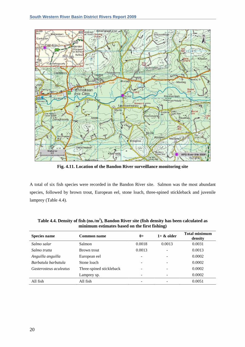
Fig. 4.11. Location of the Bandon River surveillance monitoring site
A total of six fish species were recorded in the Bandon River site. Salmon was the most abundant
species, followed by brown trout, European eel, stone loach, three-spined stickleback and juvenile
lamprey (Table 4.4).
Table 4.4. Density of fish (no./m2), Bandon River site (fish density has been calculated as minimum estimates based on the first fishing)
Species name Common name 0+ 1+ & older Total minimum
density Salmo salar Salmon 0.0018 0.0013 0.0031
Salmo trutta Brown trout 0.0013 - 0.0013
Anguilla anguilla European eel - - 0.0002
Barbatula barbatula Stone loach - - 0.0002
Gasterosteus aculeatus Three-spined stickleback - - 0.0002
Lamprey sp. - - 0.0002
All fish All fish - - 0.0051
The Central and Regional Fisheries Boards
21
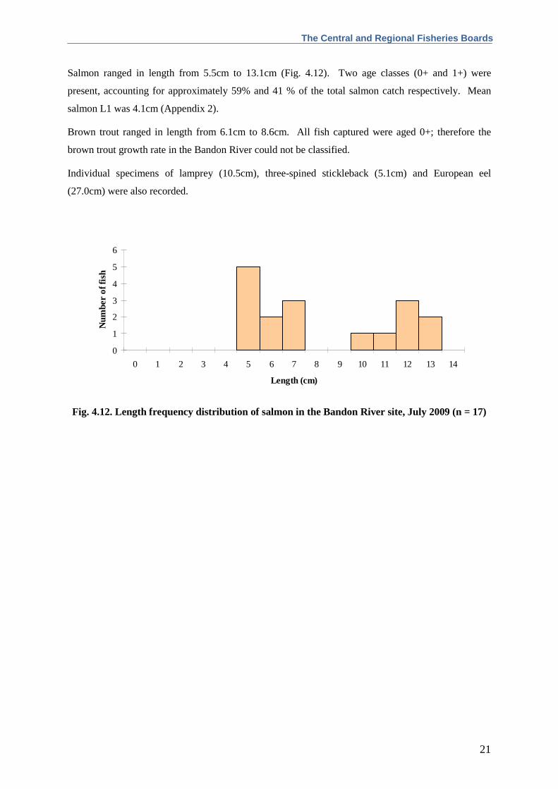
Salmon ranged in length from 5.5cm to 13.1cm (Fig. 4.12). Two age classes (0+ and 1+) were
present, accounting for approximately 59% and 41 % of the total salmon catch respectively. Mean
salmon L1 was 4.1cm (Appendix 2).
Brown trout ranged in length from 6.1cm to 8.6cm. All fish captured were aged 0+; therefore the
brown trout growth rate in the Bandon River could not be classified.
Individual specimens of lamprey (10.5cm), three-spined stickleback (5.1cm) and European eel
(27.0cm) were also recorded.
0
1
2
3
4
5
6
0 1 2 3 4 5 6 7 8 9 10 11 12 13 14
Length (cm)
Num
ber
of f
ish
Fig. 4.12. Length frequency distribution of salmon in the Bandon River site, July 2009 (n = 17)
South Western River Basin District Rivers Report 2009
22
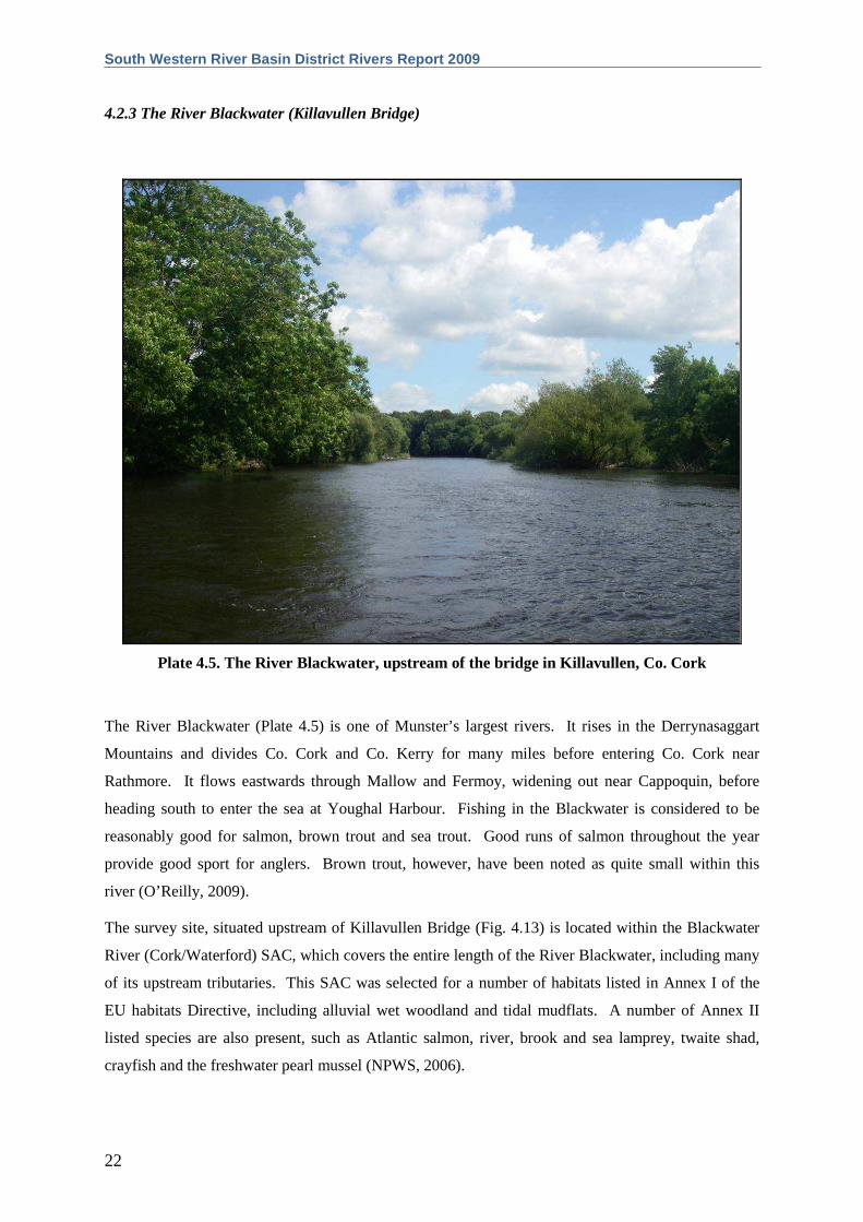
4.2.3 The River Blackwater (Killavullen Bridge)
Plate 4.5. The River Blackwater, upstream of the bridge in Killavullen, Co. Cork
The River Blackwater (Plate 4.5) is one of Munster’s largest rivers. It rises in the Derrynasaggart
Mountains and divides Co. Cork and Co. Kerry for many miles before entering Co. Cork near
Rathmore. It flows eastwards through Mallow and Fermoy, widening out near Cappoquin, before
heading south to enter the sea at Youghal Harbour. Fishing in the Blackwater is considered to be
reasonably good for salmon, brown trout and sea trout. Good runs of salmon throughout the year
provide good sport for anglers. Brown trout, however, have been noted as quite small within this
river (O’Reilly, 2009).
The survey site, situated upstream of Killavullen Bridge (Fig. 4.13) is located within the Blackwater
River (Cork/Waterford) SAC, which covers the entire length of the River Blackwater, including many
of its upstream tributaries. This SAC was selected for a number of habitats listed in Annex I of the
EU habitats Directive, including alluvial wet woodland and tidal mudflats. A number of Annex II
listed species are also present, such as Atlantic salmon, river, brook and sea lamprey, twaite shad,
crayfish and the freshwater pearl mussel (NPWS, 2006).

The Central and Regional Fisheries Boards
23
One electric-fishing pass was conducted using five boat-based electric-fishing units on the 7th of July
2009 along a 546m length of channel. This was a relatively wide stretch of channel, with a mean
wetted width of 40.0m and a mean depth of 110.0cm. The habitat consisted mainly of glide and riffle
over a substrate of cobble and gravel. Among the vegetation present was the non-native species
Himalayan balsam, which is becoming an increasing threat to river bank habitats in Ireland. A total
wetted area of 21,840m2 was surveyed.
Fig. 4.13. Location of the River Blackwater (Killavullen Br.) surveillance monitoring site
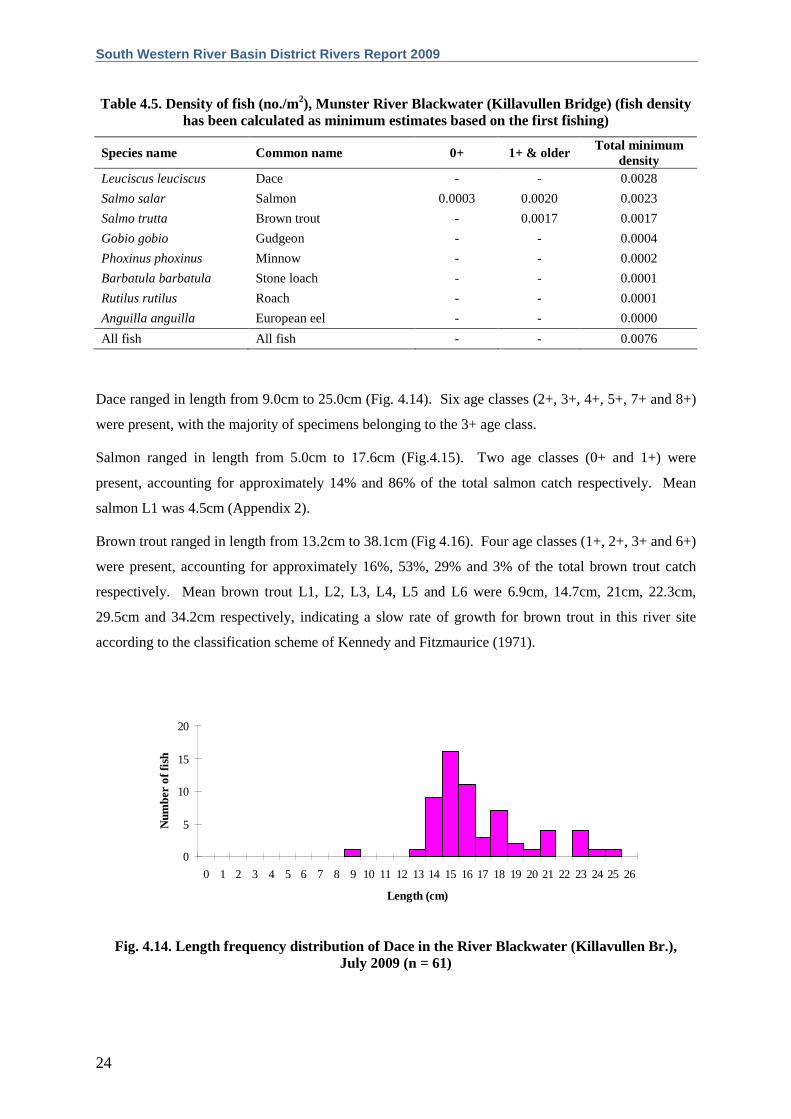
A total of eight fish species were recorded in the River Blackwater at Killavullen Bridge. Dace was
the most abundant species, followed by salmon, brown trout, gudgeon, minnow, stone loach, roach
and European eel (Table 4.5).
South Western River Basin District Rivers Report 2009
24
Table 4.5. Density of fish (no./m2), Munster River Blackwater (Killavullen Bridge) (f ish density has been calculated as minimum estimates based on the first fishing)
Species name Common name 0+ 1+ & older Total minimum
density Leuciscus leuciscus Dace - - 0.0028
Salmo salar Salmon 0.0003 0.0020 0.0023
Salmo trutta Brown trout - 0.0017 0.0017
Gobio gobio Gudgeon - - 0.0004
Phoxinus phoxinus Minnow - - 0.0002
Barbatula barbatula Stone loach - - 0.0001
Rutilus rutilus Roach - - 0.0001
Anguilla anguilla European eel - - 0.0000
All fish All fish - - 0.0076
Dace ranged in length from 9.0cm to 25.0cm (Fig. 4.14). Six age classes (2+, 3+, 4+, 5+, 7+ and 8+)
were present, with the majority of specimens belonging to the 3+ age class.
Salmon ranged in length from 5.0cm to 17.6cm (Fig.4.15). Two age classes (0+ and 1+) were
present, accounting for approximately 14% and 86% of the total salmon catch respectively. Mean
salmon L1 was 4.5cm (Appendix 2).
Brown trout ranged in length from 13.2cm to 38.1cm (Fig 4.16). Four age classes (1+, 2+, 3+ and 6+)
were present, accounting for approximately 16%, 53%, 29% and 3% of the total brown trout catch
respectively. Mean brown trout L1, L2, L3, L4, L5 and L6 were 6.9cm, 14.7cm, 21cm, 22.3cm,
29.5cm and 34.2cm respectively, indicating a slow rate of growth for brown trout in this river site
according to the classification scheme of Kennedy and Fitzmaurice (1971).
0
5
10
15
20
0 1 2 3 4 5 6 7 8 9 10 11 12 13 14 15 16 17 18 19 20 21 22 23 24 25 26
Length (cm)
Num
ber
of f
ish
Fig. 4.14. Length frequency distribution of Dace in the River Blackwater (Killavullen Br.), July 2009 (n = 61)

The Central and Regional Fisheries Boards
25
0
5
10
15
20
25
0 1 2 3 4 5 6 7 8 9 10 11 12 13 14 15 16 17 18
Length (cm)
Num
ber
of f
ish
Fig. 4.15. Length frequency distribution of salmon in the River Blackwater (Killavullen Br.), July 2009 (n = 50)
0
1
2
3
4
5
6
7
0 2 4 6 8 10 12 14 16 18 20 22 24 26 28 30 32 34 36 38
Length (cm)
Num
ber
of f
ish
Fig. 4.16. Length frequency distribution of brown trout in the River Blackwater (Killavullen Br.), July 2009 (n = 38)

South Western River Basin District Rivers Report 2009
26
4.2.4 The River Blackwater (Nohaval Bridge)
Plate 4.6. The River Blackwater (Nohaval Br.), upstream of Rathmore, Co. Cork
A second site on the River Blackwater was surveyed, just upstream of Nohaval Bridge (Plate 4.6),
approximately 2km north of Rathmore, Co. Cork (Fig. 4.17). This site is also located within the
Blackwater River (Cork/Waterford) SAC. See Section 4.2.3 of this report for further details.
One electric-fishing pass was conducted using two boat-based electric-fishing units on the 23rd of July
2009 along a 178m length of channel. The mean wetted width of the stretch surveyed was 11.4m and
the mean depth was 44.0cm. Riffle and pool dominated the habitat, whilst the most common substrate
was cobble. The invasive plant, Himalayan balsam was also present at this site. A total wetted area
of 2,029m2 was surveyed.

The Central and Regional Fisheries Boards
27
Fig. 4.17. Location of the River Blackwater (Nohaval Br.) surveillance monitoring site
A total of five fish species were recorded in the River Blackwater, Nohaval Bridge site. Brown trout
was the most abundant species, followed by salmon, minnow, European eel and stone loach (Table
4.6).
Table 4.6. Density of fish (no./m2), River Blackwater (Nohaval Br. site) (fish density has been calculated as minimum estimates based on the first fishing)
Species name Common name 0+ 1+ & older Total minimum
density Salmo trutta Brown trout - 0.0246 0.0246
Salmo salar Salmon 0.0010 0.0059 0.0069
Phoxinus phoxinus Minnow - - 0.0025
Anguilla anguilla European eel - - 0.0010
Barbatula barbatula Stone loach - - 0.0005
All fish All fish - - 0.0355
Brown trout ranged in length from 12.3 to 26.4cm (Fig 4.18). Four age classes (1+, 2+, 3+ and 4+)
were present, accounting for approximately 42%, 42%, 14% and 2% of the total brown trout catch
respectively. Mean brown trout L1, L2, L3 and L4 were 7.3cm, 15.3cm, 20.2cm and 25.1cm

South Western River Basin District Rivers Report 2009
28
respectively, indicating a slow rate of growth for brown trout in this river site according to the
classification scheme of Kennedy and Fitzmaurice (1971).
Salmon ranged in length from 5.4cm to 11.9cm (Fig.4.19). Two age classes (0+ and 1+) were
present, accounting for approximately 14% and 86% of the total salmon catch respectively. Mean
salmon L1 was 4.6cm (Appendix 2).
Minnow ranged in length from 5.8cm to 6.8cm. European eels ranged from 25.5cm to 31.8cm, and
one 9.0cm stone loach was also recorded.
012345678
0 1 2 3 4 5 6 7 8 9 10 11 12 13 14 15 16 17 18 19 20 21 22 23 24 25 26 27
Length (cm)
Num
ber
of f
ish
Fig. 4.18. Length frequency distribution of brown trout in the River Blackwater (Nohaval Br.), July 2009 (n = 50)
0
1
2
3
4
5
0 1 2 3 4 5 6 7 8 9 10 11 12
Length (cm)
Num
ber
of f
ish
Fig. 4.19. Length frequency distribution of salmon in the River Blackwater (Nohaval Br.), July 2009 (n = 14)

The Central and Regional Fisheries Boards
29
4.2.5 The River Bride
Plate 4.7. The River Bride, east of Castlelyons, Co. Cork
The River Bride (Plate 4.7) is a large tributary of the River Blackwater (Munster). It rises in the
Nagles Mountains of north Co. Cork and flows eastwards before joining the River Blackwater near
Villierstown in Co. Waterford. It remains tidal for a relatively long stretch, from the River
Blackwater confluence up as far as Tallowbridge. Salmon, brown trout and sea trout fishing are all
popular on the River Bride (O’Reilly, 2009). The tidal reaches provide an important refuge for fish in
low water, until higher levels allow passage further upstream (O’Reilly, 2009).
The survey site was located in Co. Cork, just upstream of a ford and footbridge, a few kilometres
south-east of Castlelyons (Fig. 4.20). This site is also located within the Blackwater River
(Cork/Waterford) SAC. For more details see Section 4.2.3 of this report. One electric-fishing pass
was conducted using three boat-based electric-fishing units on the 24th of July 2009 along a 283m
length of river channel. The mean wetted width of the stretch surveyed was 16.8m and the mean
depth was 46.0cm. The channel was entirely composed of glide over a substrate of gravel and cobble.
The invasive bank-side plants, Himalayan balsam and giant hogweed were both present at this site. A
total wetted area of 4,754m2 was surveyed.

South Western River Basin District Rivers Report 2009
30
Fig. 4.20. Location of the River Bride surveillance monitoring site
A total of four fish species were recorded in the River Bride site, as well as sea trout. Salmon was the
most abundant species, followed by brown trout, European eel and stone loach (Table 4.7).
Table 4.7. Density of fish (no./m2), River Bride site (fish density has been calculated as minimum estimates based on the first fishing)
Species name Common name 0+ 1+ & older Total minimum
density Salmo salar Salmon 0.0044 0.0143 0.0187
Salmo trutta Brown trout 0.0004 0.0164 0.0168
Anguilla anguilla European eel - - 0.0011
Barbatula barbatula Stone loach - - 0.0006
Salmo trutta Sea trout - - 0.0002
All fish All fish - - 0.0374
Salmon ranged in length from 5.5cm to 14.1cm (Fig.4.21). Two age classes (0+ and 1+) were
present, accounting for approximately 24% and 76% of the total salmon catch respectively. Mean
salmon L1 was 5.9cm (Appendix 2).
The Central and Regional Fisheries Boards
31
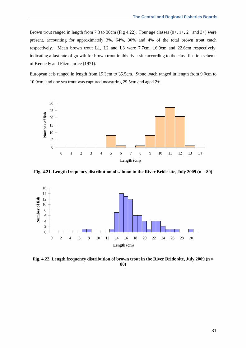
Brown trout ranged in length from 7.3 to 30cm (Fig 4.22). Four age classes (0+, 1+, 2+ and 3+) were
present, accounting for approximately 3%, 64%, 30% and 4% of the total brown trout catch
respectively. Mean brown trout L1, L2 and L3 were 7.7cm, 16.9cm and 22.6cm respectively,
indicating a fast rate of growth for brown trout in this river site according to the classification scheme
of Kennedy and Fitzmaurice (1971).
European eels ranged in length from 15.3cm to 35.5cm. Stone loach ranged in length from 9.0cm to
10.0cm, and one sea trout was captured measuring 29.5cm and aged 2+.
0
5
10
15
20
25
30
0 1 2 3 4 5 6 7 8 9 10 11 12 13 14
Length (cm)
Num
ber
of f
ish
Fig. 4.21. Length frequency distribution of salmon in the River Bride site, July 2009 (n = 89)
02468
10121416
0 2 4 6 8 10 12 14 16 18 20 22 24 26 28 30
Length (cm)
Num
ber
of f
ish
Fig. 4.22. Length frequency distribution of brown trout in the River Bride site, July 2009 (n =
80)
South Western River Basin District Rivers Report 2009
32
4.3 Community structure
4.3.1 Species richness and composition
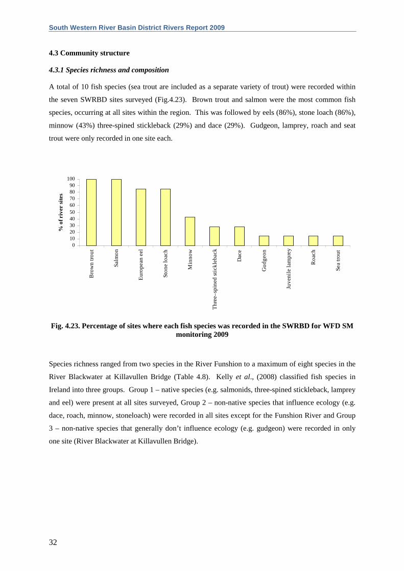
A total of 10 fish species (sea trout are included as a separate variety of trout) were recorded within
the seven SWRBD sites surveyed (Fig.4.23). Brown trout and salmon were the most common fish
species, occurring at all sites within the region. This was followed by eels (86%), stone loach (86%),
minnow (43%) three-spined stickleback (29%) and dace (29%). Gudgeon, lamprey, roach and seat
trout were only recorded in one site each.
0102030405060708090
100
Bro
wn
tro
ut
Sa
lmo
n
Eu
rop
ea
n e
el
Sto
ne
loa
ch
Min
no
w
Th
ree
–sp
ine
d s
tickl
eb
ack
Da
ce
Gu
dg
eo
n
Juve
nile
lam
pre
y
Ro
ach
Se
a t
rou
t
% o
f riv
er s
ites
Fig. 4.23. Percentage of sites where each fish species was recorded in the SWRBD for WFD SM
monitoring 2009
Species richness ranged from two species in the River Funshion to a maximum of eight species in the
River Blackwater at Killavullen Bridge (Table 4.8). Kelly et al., (2008) classified fish species in
Ireland into three groups. Group 1 – native species (e.g. salmonids, three-spined stickleback, lamprey
and eel) were present at all sites surveyed, Group 2 – non-native species that influence ecology (e.g.
dace, roach, minnow, stoneloach) were recorded in all sites except for the Funshion River and Group
3 – non-native species that generally don’t influence ecology (e.g. gudgeon) were recorded in only
one site (River Blackwater at Killavullen Bridge).
The Central and Regional Fisheries Boards
33
Table 4.8. Species richness at each river site surveyed in the SWRBD, July to October 2009
Site
Species richness
No. native species (Group 1)
No. non-native species (Group 2)
No. non-native species (Group 3)
HAND-SET SITES Argideen 6 4 2 0 Funshion 2 2 0 0
BOAT SITES Blackwater (Killavullen Br.) 8 3 4 1 Bandon 6 5 1 0 Awbeg (Buttevant) 5 3 2 0 Blackwater (Nohaval Br.) 5 3 2 0 Bride 4 3 1 0
4.3.2 Species abundance and distribution
Abundance (minimum population density) and distribution maps for the most common fish species
recorded within the SWRBD during 2009 are shown below in Figures 4.24 to 4.43. Recorded fish
densities are generally much higher in surveys using hand-set electric-fishing gear than in those
conducted with boat-based electric-fishing gear. This is primarily due to the tendency for younger
trout and salmon to utilise shallow, riffle areas as nursery habitat and may also be due to the
difference in sampling efficiency of the two methods. As such, population densities recorded for each
species using the two methods are displayed on separate maps. For comparative purposes, densities
from surveys conducted during 2008 are also displayed.
Brown trout were present at all seven of the sites surveyed. The highest density of brown trout fry
(0+) amongst boat sites was in the Bandon River site (0.001 fish/m2, Fig 4.24), whilst the highest
density of 1+ and older brown trout amongst boat sites was in the River Blackwater at Nohaval Bridge
(0.02 fish/m2, Fig. 4.26). The highest density of both brown trout fry (0+) and 1+ and older fish
recorded amongst the hand-set sites was in the River Funshion site (0.07 fish/m2 and 0.04 fish/m2
respectively, Fig. 4.25 and Fig. 4.27). The River Bride site was the only river in which sea trout were
recorded (0.0002 fish/m2).
Salmon were also recorded in all of the SWRBD sites surveyed. The highest density of 0+ salmon
recorded amongst boat sites was in the River Bride site (0.004 fish/m2, Fig. 4.28), whilst the highest
density of 1+ and older salmon was in the Awbeg River site (0.02 fish/m2, Fig. 4.30). The highest
density of both salmon fry (0+) and parr (1+ and older) amongst hand-set sites were recorded in the
Argideen River site with values of 0.15 fish/m2 and 0.10 fish/m2 respectively (Fig. 4.29 and Fig. 4.31).
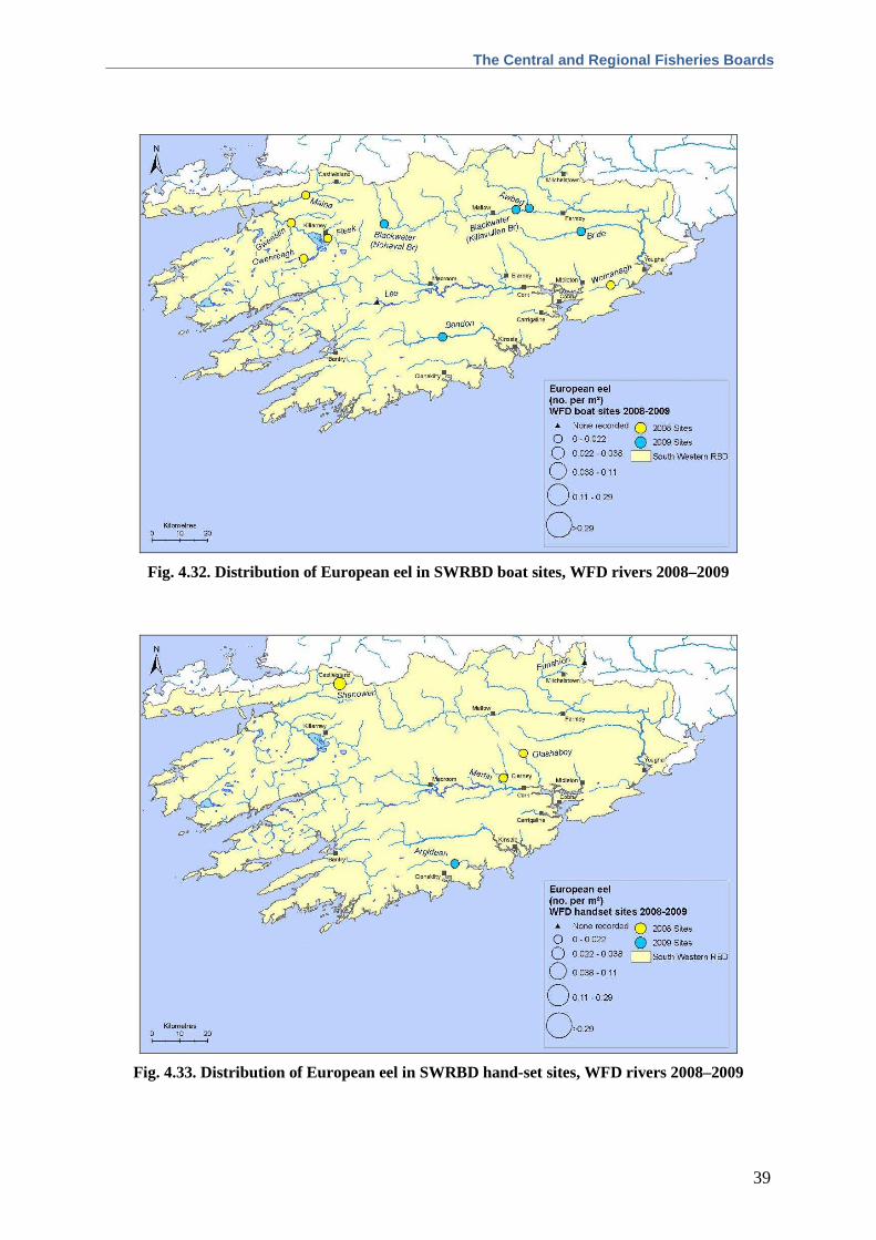
European eels were also well distributed throughout the SWRBD, occurring in six sites (Fig. 4.32 and
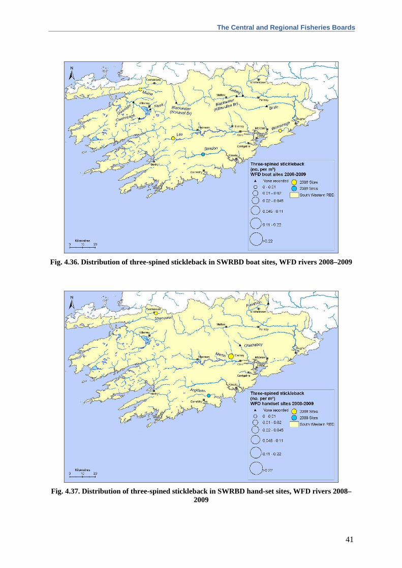
Fig. 4.33). They were only absent from the River Funshion site. Three-spined stickleback were only
recorded in two sites in the southern end of the region, in the Bandon and Argideen Rivers (Fig. 4.36
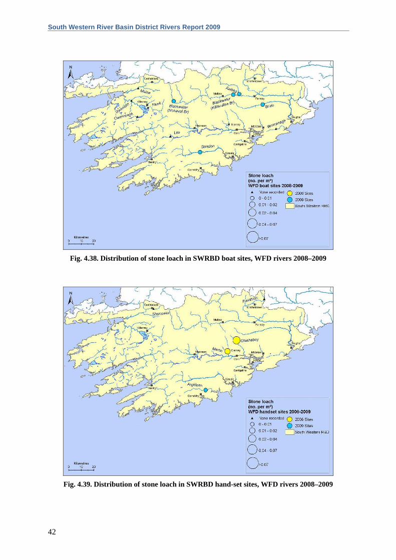
and Fig. 4.37). Stone loach exhibited the same distribution as eels, only being absent from the River

South Western River Basin District Rivers Report 2009
34
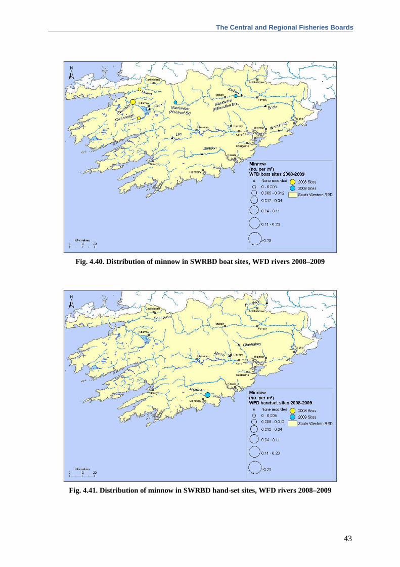
Funshion site (Fig. 4.38 and Fig. 4.39). Minnow were recorded in three sites (Fig 4.40 and Fig. 4.41),
the River Blackwater (Killavullen), River Blackwater (Nohaval) and Argideen River. Dace were
recorded in the River Blackwater (Killavullen) and Awbeg River (Fig. 4.42 and Fig. 4.43). Gudgeon,
Lamprey and Roach were only found in a single location, the River Blackwater at Killavullen Bridge.

The Central and Regional Fisheries Boards
35
Fig. 4.24. Distribution of 0+ brown trout in SWRBD boat sites, WFD rivers 2008–2009
Fig. 4.25. Distribution of 0+ brown trout in SWRBD hand-set sites, WFD rivers 2008–2009

South Western River Basin District Rivers Report 2009
36
Fig. 4.26. Distribution of 1+ or older brown trout in SWRBD boat sites, WFD rivers 2008–2009
Fig. 4.27. Distribution of 1+ or older brown trout in SWRBD hand-set sites, WFD rivers 2008–2009

The Central and Regional Fisheries Boards
37
Fig. 4.28. Distribution of 0+ salmon in SWRBD boat sites, WFD rivers 2008–2009
Fig. 4.29. Distribution of 0+ salmon in SWRBD hand-set sites, WFD rivers 2008–2009

South Western River Basin District Rivers Report 2009
38
Fig. 4.30. Distribution of 1+ or older salmon in SWRBD boat sites, WFD rivers 2008–2009
Fig. 4.31. Distribution of 1+ or older salmon in SWRBD hand-set sites, WFD rivers 2008–2009
The Central and Regional Fisheries Boards
39
Fig. 4.32. Distribution of European eel in SWRBD boat sites, WFD rivers 2008–2009
Fig. 4.33. Distribution of European eel in SWRBD hand-set sites, WFD rivers 2008–2009

South Western River Basin District Rivers Report 2009
40
Fig. 4.34. Distribution of lamprey in SWRBD boat sites, WFD rivers 2008–2009
Fig. 4.35. Distribution of lamprey in SWRBD hand-set sites, WFD rivers 2008–2009
The Central and Regional Fisheries Boards
41
Fig. 4.36. Distribution of three-spined stickleback in SWRBD boat sites, WFD rivers 2008–2009
Fig. 4.37. Distribution of three-spined stickleback in SWRBD hand-set sites, WFD rivers 2008–2009
South Western River Basin District Rivers Report 2009
42
Fig. 4.38. Distribution of stone loach in SWRBD boat sites, WFD rivers 2008–2009
Fig. 4.39. Distribution of stone loach in SWRBD hand-set sites, WFD rivers 2008–2009
The Central and Regional Fisheries Boards
43
Fig. 4.40. Distribution of minnow in SWRBD boat sites, WFD rivers 2008–2009
Fig. 4.41. Distribution of minnow in SWRBD hand-set sites, WFD rivers 2008–2009

South Western River Basin District Rivers Report 2009
44
Fig. 4.42. Distribution of dace in SWRBD boat sites, WFD rivers 2008–2009
Fig. 4.43. Distribution of dace in SWRBD hand-set sites, WFD rivers 2008–2009

The Central and Regional Fisheries Boards
45
4.3.3 Age and growth of brown trout and salmon
Age and growth were determined for brown trout and salmon, which were the dominant fish species
at most sites. Brown trout ages ranged from 0+ to 6+, with 0+ and 1+ being the dominant age classes
at most sites. The largest brown trout (6+, length 38.1cm and weight 0.60kg) recorded was captured
on the River Blackwater at Killavullen Bridge. Juvenile salmon were recorded in three age classes;
0+, 1+ and 2+, with the majority within the 1+ age category. The largest salmon recorded was
captured in the River Bride, measuring 14.1cm in length.
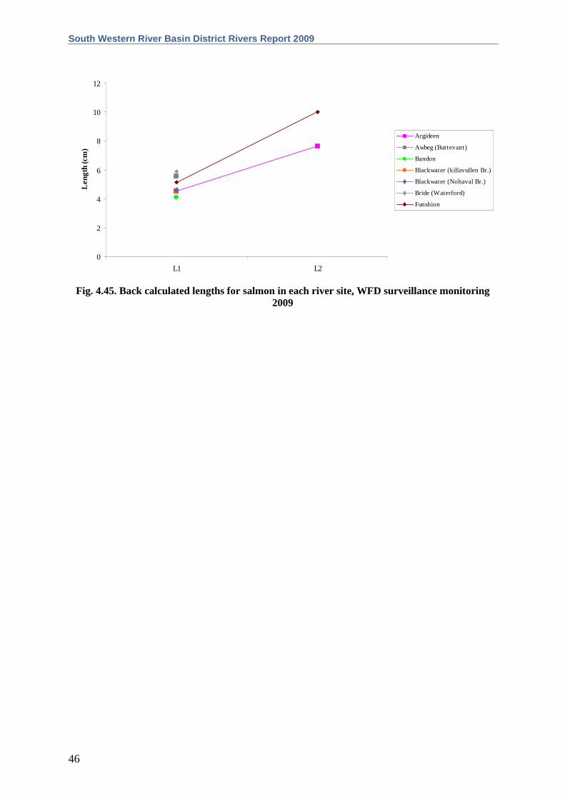
Length-at-age analyses and growth curves are presented for brown trout (Fig. 4.44 and Appendix 1)
and salmon (Fig. 4.45 and Appendix 2). The brown trout at each river site were assigned growth
categories described by Kennedy and Fitzmaurice (1971), who examined the relationship between
alkalinity and growth of trout in Irish streams and rivers. Growth was classified as very slow in the
River Funshion, slow in the Argideen River, Awbeg River, River Blackwater (Killavullen) and River
Blackwater (Nohaval) and fast on the River Bride.
The River Bride had the highest mean salmon L1. Data for mean salmon L2 were only available for
the Argideen River and the River Funshion, which had the higher of the two (Fig. 4.45).
0
5
10
15
20
25
30
35
40
L1 L2 L3 L4 L5 L6
Leng
th (c
m)
Argideen
Awbeg (Buttevant)
Blackwater (Killavullen)
Blackwater (Nohaval)
Bride (Waterford)
Funshion
Fig. 4.44. Back calculated lengths for brown trout in each river site, WFD surveillance
monitoring 2009
South Western River Basin District Rivers Report 2009
46
0
2
4
6
8
10
12
L1 L2
Leng
th (c
m)
Argideen
Awbeg (Buttevant)
Bandon
Blackwater (killavullen Br.)
Blackwater (Nohaval Br.)
Bride (Waterford)
Funshion
Fig. 4.45. Back calculated lengths for salmon in each river site, WFD surveillance monitoring
2009

The Central and Regional Fisheries Boards
47
5. DISCUSSION
A total of eleven fish species (sea trout are included as a separate variety of trout) were recorded in
the SWRBD during the 2009 WFD surveillance monitoring program. This is comparable to the
number of species recorded in other River Basin Districts. The main summary report provides results
for the whole country (Kelly et al., 2010).
Brown trout and salmon were the two most widely distributed species in the SWRBD, occurring in all
seven sites. The River Blackwater (Killavullen Bridge) was the most diverse site, with eight species
present. The highest species diversity recorded in any site throughout the country was eleven and this
only occurred in one site within the SERBD where a high number of non-native fish species were
present. The River Funshion had the lowest diversity within the SWRBD, with only two species
present. Such a low species diversity is commonly found around Ireland in small wadeable streams
that contain only native fish species (Kelly et al., 2009).
The River Bride was the only river in which sea trout were recorded. European eels and stone loach
were also well distributed, only being absent from the River Funshion. Minnow were recorded in
three sites, while three-spined stickleback were present in only two sites. Dace, which are becoming
more of a concern in the region due mainly to the potential competition for resources with native
brown trout populations, were captured at two sites, the River Blackwater (Killavullen) and the
Awbeg River. Gudgeon, lamprey and roach were also all found in one single location; the River
Blackwater at Killavullen Bridge.
Ireland’s indigenous fauna has come under increasing threat from non-native introductions. Invasions
by non-native species represent one of the greatest threats to natural biodiversity, second only to
habitat destruction (Scalera and Zaghi, 2004). Non-native and invasive species can transform
ecosystems, threatening both indigenous and high conservation status species (Stokes et al., 2006),
with impacts including displacement through competition for space and food. Direct impacts through
predation are also evident (Barton and Heard, 2005).
Non-native fish species were recorded in six of the seven rivers surveyed in the SWRBD. Eno et al.
(1997) differentiate between both non-native and alien species, with the former being those that have
established themselves and the latter being those that have not established themselves and cannot do
so without some sort of human intervention. The only river containing exclusively native fish was the
River Funshion. Kelly et al. (2008) categorised non-native species in Ireland into two categories
(Group 2, which are those that influence the ecology, and Group 3, which are those that generally
have no influence on the ecology). Four Group 2 species (minnow, dace, stone loach and roach) and
one Group 3 species (gudgeon) were recorded within the SWRBD. The presence of dace is
particularly pertinent due to the potential negative impacts on the native salmonid populations.

South Western River Basin District Rivers Report 2009
48
Following the methods of Kennedy and Fitzmaurice (1971), brown trout growth was classified as very
slow in the River Funshion, slow in the Argideen River, Awbeg River, River Blackwater (Killavullen)
and River Blackwater (Nohaval) and fast on the River Bride.
An essential step in the WFD process is the classification of the ecological status of lakes, rivers and
transitional waters, which in turn will assist in identifying objectives that must be set in the individual
River Basin District Management Plans. No fish classification method currently exists in Ireland for
classifying river water quality based on fish populations. Currently, ecological status classifications
are based on expert opinion using information collected during a project to investigate the relationship
between fish stocks, ecological quality ratings (Q-values), environmental factors and degree of
eutrophication (Kelly et al., 2007c). An ecological classification tool, however, is being developed
for the Republic of Ireland and Northern Ireland, along with a separate version for Scotland to comply
with the requirements of the WFD. Agencies throughout each of the three regions have contributed
data to be used in the model, which is being developed under the management of the Scotland &
Northern Ireland Forum for Environmental Research (SNIFFER). It was recommended during the
earlier stages of this project that an approach similar to that developed by the Environment Agency in
England and Wales (FCS2) be used. This scheme works by comparing various fish community
metric values within a site (observed) to those predicted (expected) for that site under reference (un-
impacted) conditions using a geo-statistical model based on bayesian probabilities. The proposed
method will provide an Ecological Quality Ratio (EQR) between 1 and 0 for all sites. Five class
boundaries will be defined along this range, to correspond with the five ecological status classes of
High, Good, Moderate, Poor and Bad. Confidence levels will then be assigned to each class and
represented as probabilities. Work on the rivers classification tool is still ongoing and is due for
completion in mid-2010.

The Central and Regional Fisheries Boards
49
6. REFERENCES
Barton, E. and Heard, J. (2005) Alien, Non-native and Invasive Marine Species. Marine Life Topic
Note. The Marine Biological Association of the United Kingdom. Available at:
http://www.marlin.ac.uk/PDF/MLTN_alien_non_natives.pdf
CEN (2003) Water Quality—Sampling of Fish with Electricity. European Standard. Ref. No. EN
14011:2000.
Council of the European Communities (2000) Establishing a framework for Community action in the
field of water policy. Directive of the European Parliament and of the Council establishing a
framework for community action in the field of water policy (2000/60/EC). Official Journal of
the European Communities, 43, 1-73.
Eno, N.C., Clark, R.A. and Sanderson, W.G. (1997) Non-native Marine Species in British
Waters: a review and directory. Peterborough: Joint Nature Conservation Committee.
Kelly, F., Harrison, A., Connor, L., Allen, M., Rosell, R. and Champ, T. (2008) North South Shared
Aquatic Resource (NS Share) Lakes Project: FISH IN LAKES: Task 6.9: Classification tool
for Fish in Lakes. Final Report. Available at: www.nsshare.com
Kelly, F., Connor, L., Wightman, G., Matson, R., Morrissey, E., O’Callaghan, R., Feeney, R., Hanna,
G. and Rocks, K. (2009) Sampling Fish for the Water Framework Directive - Summary
Report 2008. CFB unpublished report.
Kelly, F.L., Harrison, A.J., Connor, L., Matson, R., Wightman, G., Morrissey, E., O’Callaghan, R.,
Feeney, R., Hanna, G., Wogerbauer, C. and Rocks, K. (2010) Sampling fish for the Water
Framework Directive – Summary report 2009. CFB unpublished report.
Kennedy, M. and Fitzmaurice, P. (1971) Growth and Food of Brown Trout Salmo Trutta (L.) in Irish
Waters. Proceedings of the Royal Irish Academy, 71 (B) (18), 269-352.
NPWS (2006) Blackwater River (Cork/Waterford) SAC. Site Synopsis, Site code: 002170. Available
at http://www.npws.ie/en/media/Media,4178,en.pdf
O’Reilly, P. (2009) Rivers of Ireland, a Flyfisher’s Guide (7th Edition). Merlin Unwin Books,
Shropshire, UK.
Scalera, R. and Zaghi, D. (2004) Alien species and nature conservation in the EU. The role of the
LIFE program. LIFE focus European Communities Luxembourg, 56 pp. Available at:
http://ec.europa.eu/environment/life/publications/lifepublications/lifefocus/documents/alienspec
ies_en.pdf

South Western River Basin District Rivers Report 2009
50
Stokes, K., O’Neill, K. and McDonald, R.A. (2006) Invasive species in Ireland. Report to
Environment and Heritage Service and National Parks and Wildlife Service. Quercus, Queens
University Belfast, Environment and Heritage Service Belfast and National Parks and Wildlife
Service Dublin, 151 pp. Available at: http://www.npws.ie/en/media/Media,3701 ,en.pdf
SWRBD (2009) South Western River Basin Management Plan (2009-2015). South Western River
Basin District.

The Central and Regional Fisheries Boards
51
APPENDIX 1
Summary of the growth of brown trout in rivers (L1=back calculated length at the end of the first winter etc.)
River L1 L2 L3 L4 L5 L6 Growth category Argideen Mean 5.8 15.2 Slow S.D. 2.9 5.2 S.E. 1.5 3.7 n 4 2 Range min. 3.4 11.5 Range max. 10.0 18.9
Awbeg (Buttevant) Mean 7.9 14.6 21.5 31.7 Slow S.D. 1.3 3.0 2.7 n/a S.E. 0.2 0.6 1.1 n/a n 37 25 6 1 Range min. 5.5 9.8 17.5 31.7 Range max. 11.1 22.7 24.7 31.7
Blackwater (Killavullen) Mean 6.9 14.7 21.0 22.3 29.5 34.2 Slow S.D. 1.8 3.7 3.0 n/a n/a n/a S.E. 0.3 0.7 0.9 n/a n/a n/a n 38 32 12 1 1 1 Range min. 3.7 8.7 16.4 22.3 29.5 34.2 Range max. 11.3 20.3 25.9 22.3 29.5 34.2 Blackwater (Nohaval) Mean 7.3 15.3 20.2 25.1 Slow S.D. 1.7 2.6 2.3 n/a S.E. 0.3 0.6 1.0 n/a n 41 23 5 1 Range min. 4.3 11.1 16.4 25.1 Range max. 10.9 23.4 22.0 25.1 Bride Mean 7.7 16.9 22.6 Fast S.D. 1.4 2.5 2.8 S.E. 0.2 0.5 2.0 n 46 22 2 Range min. 4.9 12.5 20.6 Range max. 10.6 23.0 24.6 Funshion Mean 5.5 11.2 15.9 Very slow S.D. 1.1 1.7 n/a S.E. 0.3 1.2 n/a n 17 2 1 Range min. 3.5 10.0 15.9 Range max. 7.0 12.4 15.9
South Western River Basin District Rivers Report 2009
52
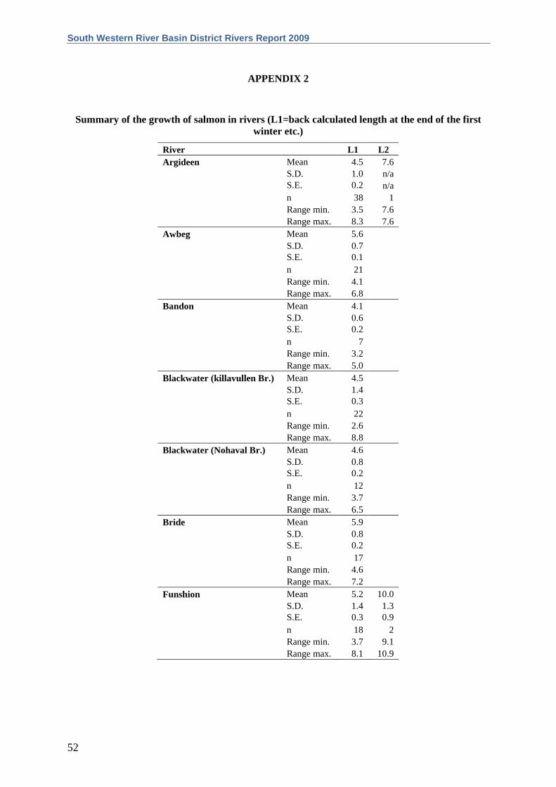
APPENDIX 2
Summary of the growth of salmon in rivers (L1=back calculated length at the end of the first winter etc.)
River L1 L2 Argideen Mean 4.5 7.6 S.D. 1.0 n/a S.E. 0.2 n/a n 38 1 Range min. 3.5 7.6 Range max. 8.3 7.6 Awbeg Mean 5.6 S.D. 0.7 S.E. 0.1 n 21 Range min. 4.1 Range max. 6.8 Bandon Mean 4.1 S.D. 0.6 S.E. 0.2 n 7 Range min. 3.2 Range max. 5.0 Blackwater (killavullen Br.) Mean 4.5 S.D. 1.4 S.E. 0.3 n 22 Range min. 2.6 Range max. 8.8 Blackwater (Nohaval Br.) Mean 4.6 S.D. 0.8 S.E. 0.2 n 12 Range min. 3.7 Range max. 6.5 Bride Mean 5.9 S.D. 0.8 S.E. 0.2 n 17 Range min. 4.6 Range max. 7.2 Funshion Mean 5.2 10.0 S.D. 1.4 1.3 S.E. 0.3 0.9 n 18 2 Range min. 3.7 9.1 Range max. 8.1 10.9

The Central and Regional Fisheries Boards
53


