International Examinations
Professional Development for Teachers
Teaching and Assessing Skills in
Geography
Steve Sibley

PUBLISHED BY THE PRESS SYNDICATE OF THE UNIVERSITY OF CAMBRIDGE
The Pitt Building, Trumpington Street, Cambridge, United Kingdom
CAMBRIDGE UNIVERSITY PRESS
The Edinburgh Building, Cambridge CB2 2RU, UK40 West 20th Street, New York, NY 10011-4211, USA477 Williamstown Road, Port Melbourne, VIC 3207, AustraliaRuiz de Alarcón 13, 28014 Madrid, SpainDock House, The Waterfront, Cape Town 8001, South Africa
http://www.cambridge.org
© Cambridge International Examinations 2003
This book is in copyright. Subject to statutory exception and to the provisions of relevantcollective licensing agreements, no reproduction of any part may take place without thewritten permission of Cambridge University Press.
First published 2003
Printed in the United Kingdom at the University Press, Cambridge
Typefaces Meridien, Dax condensed System QuarkXPress®
A catalogue record for this book is available from the British Library
ISBN 0 521 75357 0 paperback
The publisher has used its best endeavours to ensure that the URLs for external websitesreferred to in this book are correct and active at the time of going to press. However, thepublisher has no responsibility for the websites and can make no guarantee that a site willremain live or that the content will remain appropriate.
ACKNOWLEDGEMENTS
We would like to thank the following for permission to use their material:
The article on p.60: reproduced with kind permission of Agence France Presse (AFP); Figure 1: Carter and the Geographical Association; Figures 3, 6 & 8: reproduced with the kind permission of OCR; table on p.61: Philip Allan Updates.
The photographs in the book are reproduced courtesy of Steve Sibley.
Every effort has been made to reach copyright holders. The publishers would be pleased tohear from anyone whose rights they have unwittingly infringed.

Foreword iv
1 Introduction 1
2 Planning teaching content 6
3 Teaching students of varying abilities 16
4 Using a variety of teaching strategies 34
5 The effective use of resource materials in Geography teaching 49
6 Coursework and fieldwork activities 65
7 Assessment in Geography 77
Appendix A: sources of information 92
Appendix B: glossary 95
Index 97
Contents
Contents iii

iv Foreword
Teaching is a complex and demanding profession. All over the world,societies change in response to new knowledge gained, technologicaldevelopments, globalisation and a requirement for an ever-moresophisticated and educated population. Teachers are in the forefront ofsuch social change, responding with speed and confidence to the newdemands made of them, in terms of both their knowledge and the way inwhich they teach. This series is intended to help them in their adaptationto change and in their professional development as teachers.
Curriculum changes worldwide are putting increased emphasis on theacquisition of skills as well as subject knowledge, so that students willhave the ability to respond flexibly to the swiftly changing modernenvironment. As a result, teachers must be able both to teach and assessskills and to adjust their own teaching methods to embrace a wider rangeof techniques for both teaching and assessing in the classroom. The booksin this series are practical handbooks which explore these techniques andoffer advice on how to use them to enhance the teacher’s own practice.
The handbooks are written by teachers with direct experience ofteaching and assessing skills at this level. We have asked them to write fortheir readers in such a way that the readers feel directly supported in theirprofessional development. Thus, as well as tasks for students, there aretasks for teachers, pauses for reflection and questions to be answered. Wehope that readers will find that this mixture of the practical and theprofessional helps them, both in their practice and in their own sense ofwhat it means to be an effective teacher in this modern, changing worldof international education.
Dr Kate PrettySeries Editor
Foreword

6 Planning teaching content
2 Planning teaching content
The importance of planningThe well-prepared Geography teacher will want to ensure that all detailsof courses taught are worked out well in advance. You will want to ensurethat you provide a well-balanced programme of study for each of yourclasses, identifying opportunities for students to benefit from each of thedistinctive contributions of Geography. For classes starting externalcourses, you need to prepare schemes of work which ensure that thesyllabuses are covered in full so students are adequately prepared for allassessed components. You may find it useful to consult both colleagueswithin your school and other local teachers, in order to draw on eachothers’ experiences in developing work programmes.
This chapter considers how a syllabus produced by an externalawarding body, such as Cambridge International Examinations (CIE),should be used to guide the planning of a detailed programme of study. Itlooks at how the aims and assessment objectives, as well as the contentstatements, should be used when devising units of work. It also considershow to incorporate appropriate case studies.
The examples referred to here are from the CIE IGCSE syllabuses forGeography and Development Studies. However, you can use any syllabusfor the suggested tasks.
The structure of a syllabusA syllabus produced by an awarding body is a document which outlines indetail those aspects which need to be incorporated by teachers who entercandidates for assessment in that subject. It is a vital document, used notonly by teachers to plan the details of the content and structure of theirown courses, but also by examiners when producing examination papers.
The important components of a syllabus include:● The aims of the syllabus, comprising both the educational purposes
of the course, which may be assessed in examinations, and generaloutcomes.

Planning teaching content 7
● The assessment objectives, comprising the sets of skills and activitieswhich are assessed and enable candidates to demonstrate achievement– they may be interrelated or independent.
● An outline of the assessment structure, describing the methods whichwill be used to assess what candidates know, understand and can do. Itwill include information on the format and length of each examinationcomponent, along with details of any coursework requirements. Foreach component, details will be provided of its weighting as a part of theentire assessment, along with the weighting of the assessment objectiveswhich will be tested by it.
● Details of the required curriculum content, identifying the nature ofthe subject material to be studied. It guides the teacher in selectingappropriate material and case studies to illustrate either a number ofmajor themes or a series of key concepts and questions. It may alsospecify the scale and context of study for each topic or case study.
Teacher activity 2.1
This exercise uses the syllabus for the CIE IGCSE DevelopmentStudies. However, you may choose to do the exercise using anotherexternal examination syllabus.
Use the details from either CIE IGCSE Development Studies (givenon page 8) or any other syllabus to make sure that you understandthe distinctive features of the aims, assessment objectives andassessment structure used:
● Write them out as a brief summary, imagining that you areexplaining them to a new teacher at your school.
● Try to identify which of the aims are assessed by the assessmentobjectives (and where and how they are assessed) and which aremore general learning outcomes.
Converting the syllabus into a programme of studyOnce you have internalised the aims and assessment objectives of asyllabus, it is time for you to plan a programme of study. This shouldensure that the appropriate content is delivered, while at the same timegiving students enough opportunities to develop their competence in allthe required assessment objectives. In drawing up your programme, it isalso crucial to maintain an appropriate balance between countries at

8Planning teaching content
Source: CIE IGCSE Development Studies (2002)
Aims Assessment objectives Assessment Structure
● To analyse development as a concept and in practice
within the socio-economic, political and resource
contexts of a given society
● To understand development terminology and
elementary development theory
● To acquire the skills of analysis necessary to
understand the interrelationships of socio-economic,
political and resource systems
● To critically examine and evaluate different
development strategies and experiences
● To understand both the prospects for and constraints
upon development
● To understand the interrelationships of development
at local, national, regional and international levels
● To appreciate their own actual and potential talents
and the resource potential of their environment,
so as to utilise these fully for the development of
their societies
● To participate meaningfully in community efforts
to counter poverty, exploitation and other forms
of injustice
● To develop a challenging attitude so they can act
upon their environment to change it in the best
interests of everyone
● Knowledge with
understanding
● Analysis and
evaluation
● Investigation
● Participation and
problem solving
● Paper 1: consists of questions involving
primarily the demonstration of knowledge
and understanding
● Paper 2: consists of two structured questions
based upon several pieces of related source
material, involving primarily the analysis
and evaluation of evidence
Either
● Paper 3 (Coursework): consists of the use of
research techniques and a variety of sources
in conducting an investigation into a
development problem, proposing solutions
and carrying out practical activities related
to these solutions
Or
● Paper 4 (Alternative to coursework):
candidates provided with a limited amount
of data about a development problem
which could provide the basis for a project.
They will be required to identify questions
raised by the data and to indicate ways in
which a project could be organised in order
to identify and implement solutions
Planning teaching content 9
different levels of economic development and at varied scales. Yoursyllabus may provide some guidance in choosing case studies. However, ifthis is not the case, it is wise to spread your examples across a variety ofgeographical areas, using local, regional and national examples whereappropriate. Students can often learn best from examples which are mostfamiliar to them, so it is helpful to use local case studies wherever possible.
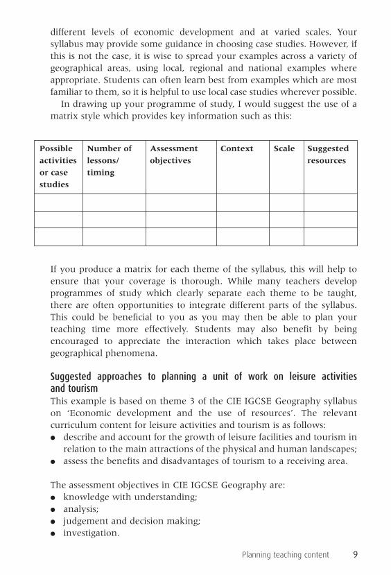
In drawing up your programme of study, I would suggest the use of amatrix style which provides key information such as this:
If you produce a matrix for each theme of the syllabus, this will help toensure that your coverage is thorough. While many teachers developprogrammes of study which clearly separate each theme to be taught,there are often opportunities to integrate different parts of the syllabus.This could be beneficial to you as you may then be able to plan yourteaching time more effectively. Students may also benefit by beingencouraged to appreciate the interaction which takes place betweengeographical phenomena.
Suggested approaches to planning a unit of work on leisure activities and tourismThis example is based on theme 3 of the CIE IGCSE Geography syllabuson ‘Economic development and the use of resources’. The relevantcurriculum content for leisure activities and tourism is as follows:● describe and account for the growth of leisure facilities and tourism in
relation to the main attractions of the physical and human landscapes;● assess the benefits and disadvantages of tourism to a receiving area.
The assessment objectives in CIE IGCSE Geography are:● knowledge with understanding;● analysis;● judgement and decision making;● investigation.
Possible Number of Assessment Context Scale Suggested
activities lessons/ objectives resources
or case timing
studies

10 Planning teaching content
It would be useful for you to set the scene by defining leisure activitiesand using statistics to describe and account for the growth of the leisureand tourist industry in a global context.
It may then be possible to use cartographic resources showing therelative popularity of various countries in a region (or areas within acountry) to tourists. This would establish the link between touristnumbers and the attractions of the physical and human environment.Atlases could be used to extract information about important physicalfactors such as climate, enabling students to look for links between theseand tourist numbers. At this stage, case studies of important touristdestinations would be appropriate. It may also be possible for you toinvolve students in investigative tasks. For example, they could find outabout the attractions of contrasting destinations, using readily availableand up-to-date materials such as tourist brochures and websites. Thiscould be done individually or in groups, and it could lead to display workor oral presentations.
The benefits and disadvantages of tourism to receiving areas shouldthen be considered, again by reference to case study materials. It may bepossible to refer to the same case studies as previously used, althoughthere may be advantages in using different case studies in order to varycontext and scale. For example, if you used a coastal resort on theMediterranean island of Majorca to illustrate the main attractions totourists, then perhaps it would be useful to look at the impacts of tourismon a country such as Kenya. This would provide a change of focus fromlocal to national, developed to developing country and European toAfrican destination.
Whatever the chosen case study, there are, of course, many interestingactivities in which students could be involved. Whether through the useof video materials or written text, they will need to be made aware ofpositive and negative impacts of tourism on people and the environmentin the chosen area. It may be possible for you to introduce an element ofrole play here, involving students in a simulation where they are requiredto empathise with individuals or interest groups who would be affectedby the expansion of tourism in the study area.
This topic is an ideal one to use to encourage an appreciation of thenatural environment amongst students and to show how people and theenvironment are interdependent. It would be an opportunity to considersustainability by involving students in making recommendations aboutthe future of tourist development in the chosen areas.

Planning teaching content 11
Teacher activity 2.2
Use some of the ideas suggested, together with any ideas of yourown, to produce a matrix which plans a unit of work on ‘Leisureactivities and tourism’ for CIE IGCSE Geography. Try to make surethat you include a variety of interesting activities, using resourcesand case studies at a variety of scales and contexts.
Alternatively, you could produce a matrix on any unit of work for asyllabus of your choice.
The use of case study materialsThe case study approach is now commonly used with most age groups. Acase study is not an end in itself, but a vehicle for achievingunderstanding and ensuring that ideas can be illustrated by using realplaces. Case studies are used to exemplify an issue or theme, and toillustrate generality rather than uniqueness. Through case studies, it ispossible to bring alive issues which may be conceptual, in order toincrease interest, motivation and understanding.
Resource materials are readily available for many case studies and youcan make sure they are topical and up to date by using newspapers,magazines and websites. Many examination syllabuses require case studyknowledge to be shown by candidates and students need to be taught insuch a way that they can:● select and recall the relevant points about their case studies;● recall details which make the case study place specific, rather than
simply adding a name to a series of general points;● show understanding of the generalisations which the case study
illustrates;● select appropriate case studies to respond to examination requirements.
In order to achieve this, you could:● use case studies to focus clearly on relevant key ideas and skills within
the syllabus;● identify opportunities to use varied resource materials in case studies;● identify geographical skills which can be developed by using resource
materials;● develop opportunities for differentiation through the resource
materials used and a variety of tasks;● develop case studies to facilitate coursework;● develop generalisations from case study specifics;● use a range of examples from different locations, scales and contexts;

12 Planning teaching content
● identify ways in which case studies are interrelated at a variety of scales;● ensure that place-specific details are available to students, to establish
an appreciation of the distinctiveness of places.
Suggested approaches to teaching case studies about floodingThe following are examples of case studies of flooding which illustrate avariety of context, scale and location. They also give some examples oflearning activities which you could use and skills which could bedeveloped by using them. The suggestions are not exhaustive and could,of course, be applied to other similar examples.
Student activity 2.1
Case study: River TrentContext: More economically developed country (MEDC)Scale: LocalLocation: UK
The River Trent floods its flood plain regularly in the area shown inFigure 2, although it is now controlled to some extent as shown inFigure 3. You could use the photograph and map to identify thepotential effects of flooding and the obvious need for management. Theresources give an ideal opportunity to reinforce terms such as ‘meander’and ‘flood plain’, as these features can easily be identified. Learningactivities could include photograph and map interpretation, withoutline maps or sketches of the area being annotated by students toindicate the disruption that flooding may cause for people in the area.
Figure 2: Flooding of the River Trent

Planning teaching content 13
Previous attempts to control flooding can be identified from the mapand there is the possibility of discussion or role play about the need forfurther protective measures. Some students could take on roles such aslocal farmers and residents of villages such as Burton Joyce, while otherscould take the roles of local councillors and flood protection experts.Discussion could follow on the costs and benefits of flood protection andthe impact of possible engineering schemes on the natural environment.
Student activity 2.2
Case study: River RhineContext: MEDCScale: RegionalLocation: Europe
Flooding of the River Rhine, particularly in lowland parts of Germanyand the Netherlands, may occur after periods of heavy rainfall. In springthis is often particularly severe, with increases in temperatures in its
BURTONJOYCE Burton
Meadow
SHELFORD
STOKEBARDOLPH
Top Farm
NottinghamSewage TreatmentWorks
FoxhillsFarm
ShelfordManor
GUNTHORPE
R. Trent
N
0 1000 metresRiver
Road
Railway
Settlements
Tracks to farms
Flood defences
Figure 3: Map of part of the flood plain of the River Trent (Source: OCRGeography A 1586/01 May/June 2002)

14 Planning teaching content
gathering grounds in the Alps melting large amounts of snow and ice.The case study is ideal to use to illustrate the climatic causes of floods. Itis possible to design learning activities which incorporate the analysis ofhydrographs (Figure 4) and the use of resource material in atlases.
A starting point could be the drawing and interpretation of a mapshowing the course of the Rhine. You could ask students to use skills suchas the use of the scale to measure the river’s length and the interpretationof the key to identify the height of the land around it in various places.You could then use the hydrograph to illustrate the impact of heavy rainon the river and explain the reasons for the time lag. Extension workcould involve the use of climatic data in order to identify periods whenmelting snow in Alpine areas is likely to be a threat.
Student activity 2.3
Case study: The floods in Mozambique in 2000Context: Less economically developed country (LEDC)Scale: NationalLocation: Africa
It is not hard to capture the interest of students when using topicalinformation and unfortunately flood events are all too regular. Their
Pre
cipi
tatio
n in
mill
imet
res
30
25
20
15
10
5
0
8
7
6
5
4
3
Dep
th o
f riv
er in
met
res
Jan 27th
Lag time
Jan 28th Jan 29th
Normal river flow
Jan 30th Jan 31st Feb 1st
Figure 4: Hydrograph of the River Rhine near Cologne


