900
1100
800
001
0
900
1100
700
600
900
1000
0
1300
1100
1400
1000
900
800
1300
1500
1800
1600
1800
1400
1300
1200
1400
1600 1300 1200
1100
1000
1200
11001400
1200
1300
1100
800
900
1000
1000
800
1000
1100
1500
1400
1300
1000
800
700
1700
1500
Corral Hollow Creek
Corral Hollow Creek
Corral Hollow Creek
CampgroundArea
MX Track
Ranger Station
70cc Track
To Interstate 580 & TracyCorral Hollow Road
Park Store
ATV Track
LowerWaterfall Canyon
(Closed)
UpperWaterfall Canyon
(Closed)
4x4 Area
Maintenance Yard
Tyson's Basin
Clear Basin
Trans Am Basin
FranciscanBasin
Lower Juniper Basin
Main SVRA Entrance
To Livermore
Tesla Road
CarrolBasin
Kiln Basin
110cc Track
Special Event Parking
SRI Loop Area
Carrol Canyon Area (Black Diamond Area)
Kiln Canyon Area
Happiness Valley Area
Dead Cow Canyon Area
Training Hill Area
Sand Hill Area
Harrison Hill Area
Trials Area
Hillclimb Event Area
BeginnersRiding Area
Kiln Canyon Trail
(Steep Grade)
SRI Loop Trail
Los Osos Tra
il
Low
er J
uniper T
rail
Juniper T
rail M
iddl
e Track Trail
Juni per Trail
Pottery Loop Trail
Dea
d C
ow C
anyo
n
Los Osos Trail
Grizzly Trail
SRI R
oad (C
LOSED TO PUBLIC)
Bunkhouse Trail
Happi
ness
Val
ley T
rail
Los
Oso
s Tr
ail
Carro
l Clim
b
Serp
entine Trail
Ridge Tra
il Red
Tail
Trai
l
Ridg
e Trail
Tran
s Am Loop
Jun
iper
Tra
il
Franciscan Loop Trail
Franciscan Loop Tra
il
Water TankFr
anci
scan
Loo
p Tr
ail
Main Park Road
Francisc
an L
oop
Trai
l
Dead Bird
Juni
per T
rail
Brewer’s Trail
Dea
d Pi
g
Dea
d S
nake
Fran
cisc
an T
rail
Potte
ry
Loop Trail
Carrol Climb
SRI Road (CLO
SED
TO
PUB
LIC)
Golden Eagle Trail
Kiln
Can
yon
Trai
l
Black Bear Trail
Kiln Canyon Trail
Red Tail Trail
Los Osos
Thra
sher
Tra
il
Los Osos
Grizzly Trail
Los Osos
Los Oso
s Tra
il
Jagg
er T
rail
Sage
Tra
il
Pot
tery
Loo
p Tr
ail
Juniper Trail
Junip
er T
rail
Clear Pond Trail
Ridg
e Trail
Red
Tail T
rail
Bunk
ho
use Trail
Badge
r Tra
il
Badg er
Trai
l
Raccoon Tra
il
Rac
coon
Tra
il
Red Tail Trail
SRI R
oad
(CLO
SED T
O P
UBLIC)
Bobcat T
rail
Stovepipe Trail
Gold
en Eagle Trail
Barn O wl Tra
il
Raven Trail
2000 feet1000
Scale in feet
0
Paved Roads
Main Park Road(2 and 4 wheel vehicles)
River or Stream
Index Contour 100 ft
Contour 20 ft
Park Boundary
Trails (Motorcycles & ATVs only)Easiest Trails
More Difficult Trails
Most Difficult Trails
Open Riding Area
Trails Only Riding Area
Camping
Day Use Area
Locked Gates
Designated Crossings
Fences
First Aid
Telephone
Wheelchair Access
Riding Areas and Trails
Maintained Tracks
Special Use AreaClosed Area
Restrooms
Ranger Station
All Trails are Two Way
Open Riding Area
Trails Only Riding Area
Open Riding Area
Trails Only Riding Area
Trails Only Riding Area
NAD27 121º 31.000’ W121º 32.000’ W121º 33.000’ W121º 34.000’ W
37
º 3
7.0
00
’ N3
7º
38
.00
0’ N
y, 18600 West Corral Hollow Rd • Tracy, CA 95376 • 925.447.9027
State Vehicular Recreation AreaState Vehicular Recreation AreaCarnegie
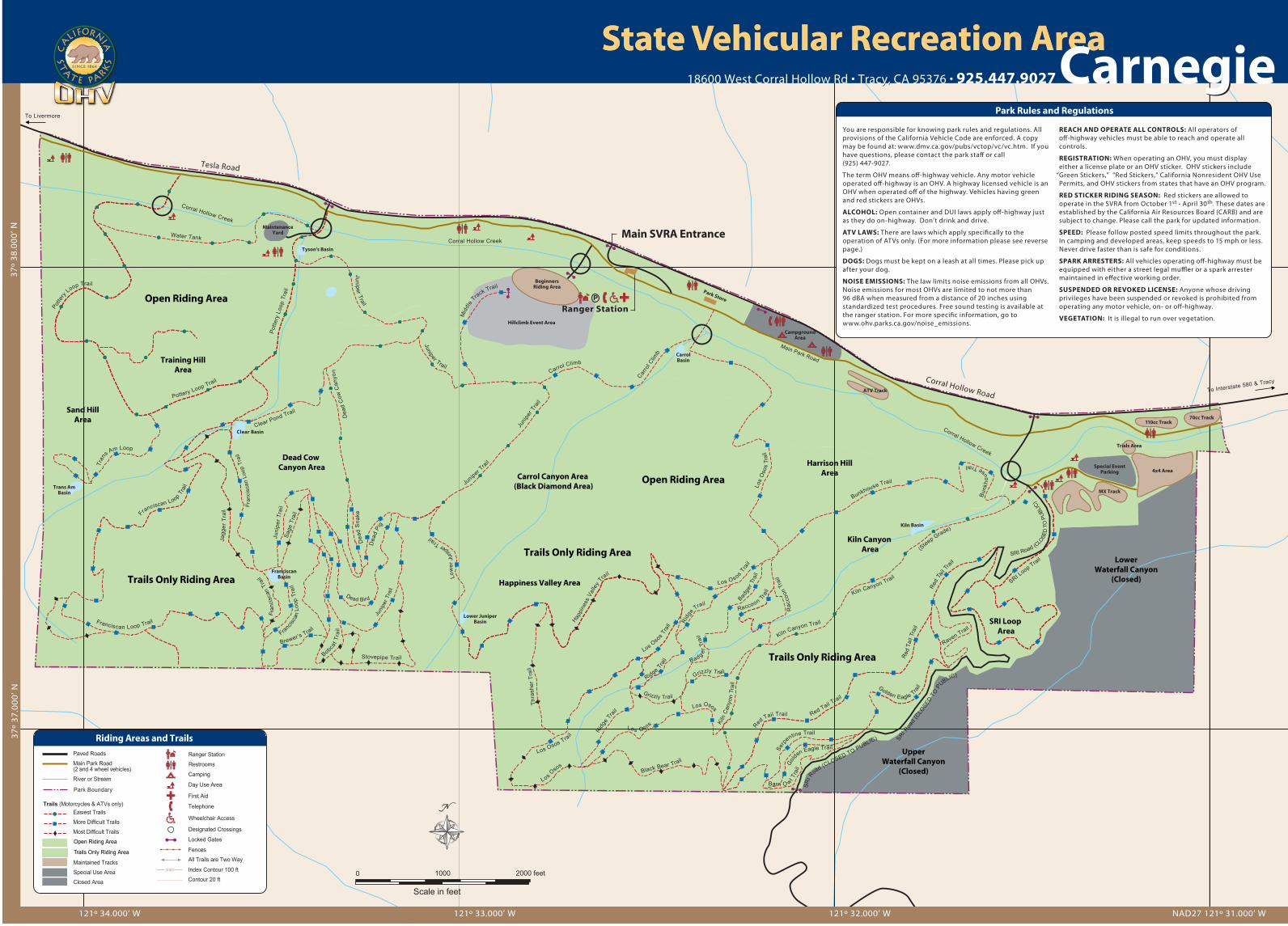
You are responsible for knowing park rules and regulations. All provisions of the California Vehicle Code are enforced. A copy may be found at: www.dmv.ca.gov/pubs/vctop/vc/vc.htm. If you have questions, please contact the park sta� or call (925) 447-9027.
The term OHV means o�-highway vehicle. Any motor vehicle operated o�-highway is an OHV. A highway licensed vehicle is an OHV when operated o� of the highway. Vehicles having green and red stickers are OHVs.
ALCOHOL: Open container and DUI laws apply o�-highway just as they do on-highway. Don’t drink and drive.
ATV LAWS: There are laws which apply speci�cally to the operation of ATVs only. (For more information please see reverse page.)
DOGS: Dogs must be kept on a leash at all times. Please pick up after your dog.
NOISE EMISSIONS: The law limits noise emissions from all OHVs. Noise emissions for most OHVs are limited to not more than 96 dBA when measured from a distance of 20 inches using standardized test procedures. Free sound testing is available at the ranger station. For more speci�c information, go to www.ohv.parks.ca.gov/noise_emissions.
REACH AND OPERATE ALL CONTROLS: All operators of o�-highway vehicles must be able to reach and operate all controls.
REGISTRATION: When operating an OHV, you must display either a license plate or an OHV sticker. OHV stickers include
“Green Stickers,” “Red Stickers,” California Nonresident OHV Use Permits, and OHV stickers from states that have an OHV program.
RED STICKER RIDING SEASON: Red stickers are allowed to operate in the SVRA from October 1st - April 30th. These dates are established by the California Air Resources Board (CARB) and are subject to change. Please call the park for updated information.
SPEED: Please follow posted speed limits throughout the park. In camping and developed areas, keep speeds to 15 mph or less. Never drive faster than is safe for conditions.
SPARK ARRESTERS: All vehicles operating o�-highway must be equipped with either a street legal mu�er or a spark arrester maintained in e�ective working order.
SUSPENDED OR REVOKED LICENSE: Anyone whose driving privileges have been suspended or revoked is prohibited from operating any motor vehicle, on- or o�-highway.
VEGETATION: It is illegal to run over vegetation.
Park Rules and Regulations


