R36-2015 R36-2015
S. ChandrashekarS. Chandrashekar
Bengaluru, India
NATIONAL INSTITUTE OF ADVANCED STUDIES
International Strategic and Security Studies Programme
December 2015December 2015
SPACE, WAR & SECURITY– A STRATEGY FOR INDIA
SPACE, WAR & SECURITY– A STRATEGY FOR INDIA

S. Chandrashekar
International Strategic & Security Studies Programme (ISSSP)
NatioNal iNstitute of advaNced studiesBengaluru
December 2015
Space, War & Security– a Strategy for india
© National Institute of Advanced Studies 2015
Published byNational Institute of Advanced StudiesIndian Institute of Science Campus,Bengaluru - 560012INDIATel: +91-80-2218 5000; Fax: +91-80-2218 5028
NIAS Report: R36-2015
ISBN 978-93-83566-19-8
Typeset & Printed byAditi EnterprisesBengaluru - 560 023Ph.: 080-2310 7302E-mail: [email protected]
iiiNatioNal iNstitute of advaNced studies
Contents
Executive Summary 1
1.0 Background 6
1.1 The Sanctuary regime in space (1960 – 1985) 9
1.2 From sanctuary to Contested Ground (1985-1990) 12
1.3 Space Contest to Space Weapons 1990 Onwards 14
1.4 China US Rivalry & the Role of Space Power 15
1.5 The World Space Power Structure 20
2.0 Indian Capacities, Capabilities & Gaps - Space Situational Awareness (SSA) 23
3.0 Capacities, Capabilities & Gaps – Space Based Command, Control,
Communications & Computers (C4) 25
3.1 The Role of Space Based Assets for C4 functions 25
3.2 GSO Communications Satellites Indian Capacities, Capabilities & trends 26
3.3 The Promise of Ion Propulsion for Reducing Satellite Mass 33
3.4 Indian GSO C4 Needs 35
3.5 A New Trend – Small Satellite Constellations for C4 needs 37
3.6 Overall Requirements of C4 Capabilities 40
4.0 Capacities, Capabilities & Gaps – Space Based Intelligence, Surveillance
& Reconnaissance (ISR) 42
4.1 Global trends in Intelligence Surveillance & Reconnaissance (ISR) 42
4.2 Indian remote Sensing Capacities, Capabilities & Trends 44
4.3 Benchmarking Indian Remote Sensing Satellites 47
4.4 Small Satellite Constellations 51
iv NatioNal iNstitute of advaNced studies
4.5 Role of Open Source Data 53
4.6 Indian Intelligence Surveillance & Reconnaissance (ISR) Needs 54
5.0 Capacities, Capabilities & Gaps – Space Based Support Services For C4ISR 57
5.1 Telemetry Tracking & Data Relay Satellites (TDRSS) 57
5.2 Weather Satellites 61
5.3 Space Based Navigation Systems 67
5.4 Space Based Support Services Overall Needs 75
5.5 Small Satellites 76
6.0 Space Launch Capacities & Capabilities 80
6.1 PSLV 80
6.2 GSLV Mark 1 & Mark 2 82
6.3 GSLV Mark 3 or LVM3 84
6.4 Larger Launchers & the Human in Space Programme 85
6.5 Role of Missile Derived Launchers for Small Satellites 86
7.0 “Ballistic Missile Defence (BMD), Anti-Satellite (ASAT) Weapons & Space
Weapons” 88
8.0 An Integrated Network Centric Space Based Strategy For India 92
8.1 An Integrated SSA & C4ISR Capability 92
8.2 Key Components of a Space Strategy 95
8.3 A Space Based Security Strategy for India 102
Abbreviations 110
1NatioNal iNstitute of advaNced studies
executive Summary
India must accept and deal with the reality that conflicts and wars in
today’s world will be based and driven by the increasing inter-dependence
between conventional, nuclear and space war.
Capabilities, Capacities, Complexity in Organization and the role of
ambiguity and escalation risk in war and war deterrence strategies will be
the new parameters along which the game will be played out. The China
US dynamic will drive the other major powers to act in different ways to
preserve and enhance their security and national power interests.
Space assets play a vital role in the formulation and implementation of
great power strategies across the globe. They act as a force multiplier that
can enhance national power and prestige.
The acceptance of this reality and the consequent need to re-organize and
re-structure the entire National Security Complex is obviously the most
important task ahead of the Indian Nation State especially if nascent
ambitions to be recognized as a global power have to be realized.
The role of space-based C4ISR assets complemented by other ground based
SSA components will be critical for deciding on the new national strategy
for waging war and for preserving the peace through the deterrence of war.
The major space based components of this new strategy architecture
would be:
• A robust SSA capability comprising radar, optical and laser tracking
facilities complemented by an organizational and human resource base
that is able to operationally monitor the space environment.
• A four-satellite constellation of advanced communications satellites in
GSO that use ion propulsion for carrying out vital C4 functions.
2 NatioNal iNstitute of advaNced studies
Space, War & Security– a Strategy for india
• A constellation of 40 satellites in LEO that provide Internet services for
the military.
• Three clusters of 3 satellites each for performing the ELINT function.
• A constellation of 12 EO and SAR satellites in appropriate Sun
Synchronous Orbits (SSO) for meeting ISR needs.
• A constellation of 24 small satellites in LEO for meeting ISR needs
during times of crises.
• Three TDRSS satellites in GSO for performing the tracking and data
relay functions needed for a C4ISR capability.
• Two operational satellites in GSO along with 3 orbiting satellites in an
800 Km SSO for meeting operational weather requirements.
• Seven satellites in Geostationary and Geosynchronous Orbits for
meeting core navigation functions.
• A 24 satellite constellation in MEO, established over a ten year period,
for providing an indigenous navigation solution.
The integration of the various SSA and C4ISR capabilities into a seamless
network that facilitates real time action is the key organizational and
institutional component of the new strategy.
To translate the above needs into an operational capability India may need
to launch 17 satellites into various GSO, SSO and other orbits every year.
(See Table 4 for details)
In addition 28 smaller satellites may also have to be launched as part of
constellations that cater to various C4ISR needs.
The Small Satellite Initiative that is needed to build small satellite capacity
in the country may also need the launching of 100 small satellites in the 5
to 100 Kg class.
To meet this requirement India needs 16 PSLV , 7 GSLV and 7 Agni 5 based
launchers every year. (See Table 4 for details)
3NatioNal iNstitute of advaNced studies
Space, War & Security– a Strategy for india
India currently builds and launches an average of about 4 satellites a year.
A four to five fold increase in the scale of the current programme is needed
to meet these emerging needs. Creating this capacity and capability to build
and launch these satellites by Indian industry would be a major challenge
for India.
With masses of about 2300 Kg (GSLV launch) and 3300 Kg (foreign launch)
Indian Communications satellites currently fall into either the medium class
category (< 2500 Kg) or the Intermediate class category (2500 -4200 Kg).
The global trend is to move away from the intermediate class of satellites to
the Heavy (4200 – 5400 Kg) or Very Heavy class (>5400 Kg) of satellites.
The use of Ion Propulsion for moving the satellite from GTO to GSO is
emerging as a new trend that promises to reverse the overall movement
towards building heavy or very heavy satellites. By adopting it as a key
component of its new strategy the current gaps in GSO satellite capabilities
can be eliminated.
This approach will also ensure that the GSLV Mark 2 launcher can now
launch the equivalent of an intermediate class GSO satellite and the GSLV
Mark 3 launcher can launch the equivalent of a heavy class satellite.
Therefore the gap between launcher capacity and satellite capabilities can
also be bridged through the adoption of this approach. This is a major
benefit since it makes possible a complete indigenous capability to meet
various strategic needs.
The creation of an ELINT capability and a TDRSS capability are major gap
areas that have to be bridged immediately.
India’s capabilities for performing the surveillance and reconnaissance parts
of the ISR function are good and close to global state-of-art capabilities.
4 NatioNal iNstitute of advaNced studies
Space, War & Security– a Strategy for india
However the use of integrated optics to combine the PAN and spectral
functions in one sensor could be an area that may need support.
Indian capabilities for dealing with the infra-red (thermal) part of the
spectrum are very limited. These need to be strengthened significantly.
Apart from ISR they are used for performing many other military functions
and could play an important part in any future BMD system.
Antenna Technology used for meeting SSA, SAR and C4 needs is also an
area that needs national attention.
Reducing the mass of the SAR, efforts to improve throughputs in data
processing especially for SAR data are other areas that may require more
support.
Indian satellites providing weather services from GSO are reasonably close
to global standards. India has so far not built any polar orbiting satellites
to complement the GSO weather data. This is an area that will also need
attention. The orbiting satellites can also be used as a base for experimenting
with new weather and climate sensors to improve operational capabilities.
India also needs to make the investments necessary to increase the human
resource base that can use publicly available high resolution remote sensing
data for use in a number of civilian and military applications. A similar
approach can also be adopted to improve the use of publicly available
weather and climate data to improve weather models.
Extending the IRNSS scheme for navigation via a MEO constellation to
improve navigation accuracies and eventually providing for a completely
indigenous solution to the navigation problem is also a part of the suggested
strategy.
The current practice of meeting both civilian and military needs for weather
5NatioNal iNstitute of advaNced studies
Space, War & Security– a Strategy for india
and navigation services via the same space segment is in tune with global
trends and can continue.
Preserving various technology options for a future space weapons
programme via development and limited testing should be a part of the
strategy.
A number of other initiatives are suggested as a part of the strategy. Details
of these can be found in Table 5 and Section 8 of this report.
India may find it difficult to move from its current position to a position
where it can simultaneously deal both with the military aspects of space
along with the human space flight programme. A sensible approach would
involve according priority to the military needs while retaining technology
development and testing options for the human space flight programme.
More than the technology initiatives the implementation of this strategy
would require a clear aspiration on the part of the Indian nation state that
it does have an important role to play on the global stage and that it will
carry out the necessary organizational and institutional reforms needed for
achieving this. Integrating the hard operational aspects created by the SSA
and C4ISR assets with the softer strategy and doctrine part of the nation
state is possibly the most difficult task confronting the country. This more
than any technology is possibly India’s greatest challenge.
All the components of the strategy suggested as well as the overall direction
and thrust are consistent with India’s current international posture of the
“peaceful uses of outer space”. This can be re-examined once India has
made progress towards achieving the status of a full-fledged space power.
6 NatioNal iNstitute of advaNced studies
1.0 Background There is no doubt that India has achieved a lot in space in spite of operating
on a relatively smaller overall space budget. The largely development driven
agenda and the civilian focus of the programme has yielded significant
benefits. This approach has also been consistent with an international
posture that advocates the peaceful uses of outer space though what is
peaceful still remains very ambiguous.
A number of developments especially over the last decade raise serious
concerns whether this continued ostrich like posture is adequate to cope
with the challenges that an emerging space power like India faces. The
role of space and space assets are emerging as key components of the
global security architecture that includes both civilian and military uses of
space. These developments pose a new set of challenges that entails a re-
examination of India’s largely civilian focused space strategy.
A dispassionate appraisal of India’s space capabilities in the context of
these challenges, raise a number of questions that may need closer scrutiny.
These are related not only to gaps in capabilities but also to institutional
and organizational bottlenecks that seem to come in the way of formulating
and implementing a space strategy that is appropriate for the country at
this point in time.
Two events stand out that reflect this state of affairs.
In January 2007 China conducted an ASAT test that destroyed a defunct
weather satellite in an 800 Km Sun Synchronous Orbit (SSO) creating
a huge debris cloud. Even though India has a number of IRS satellites
in orbits very close to this, India did not know about this test and the
consequent risk for quite some time. It was only a week or ten days after
7NatioNal iNstitute of advaNced studies
Space, War & Security– a Strategy for india
the test that the relevant Indian establishments learnt about the tests and
that also from US sources.1
As part of its Yaogan series of military satellites, China launched a
constellation of 3 satellites into an 1100 km, 63.4° inclination orbit on
a CZ 4C launcher on the 5th of March 2010. The spacing of the three
satellites, their altitude as well as the inclination is typical of an Electronic
Intelligence (ELINT) capability.
Prior to this launch, the satellites in the Yaogan series consisted of SAR and
Electro-optical imaging satellites. The launch of this 3 satellite ELINT cluster
transformed the Intelligence Surveillance Reconnaissance (ISR) capabilities
of the Peoples Liberation Army (PLA) from occasional sporadic surveillance
of high value targets such as aircraft carriers into an operational continuous
ISR system. This launch also coincided with the US declaring that China’s
Anti-Ship Ballistic Missile (ASBM) system had entered “Initial Operations
Capability.”2
Once again it took a fairly long time for the various security establishments
in the country to take stock of this development, make reasoned judgments
about the veracity of these claims and then link these to various security
challenges that India needs to address.
1 For understanding what had happened before and after the January 11 2007 test please see Michael R Gordon & David S. Cloud, “US knew of China Missile Test but Kept Silent”, New York Times, April 23 2007 at http://www.nytimes.com/2007/04/23/washington/23satellite.html?_r=1&adxnnl=1&oref=slogin&ref=asia&pagewanted=print&adxnnlx=1177412634-gIokCeqAhuEUTz6obSrvpQ
2 Andrew Erickson and Gabe Collins, “China Deploys World’s First Long-Range, Land-Based ‘Carrier Killer’: DF-21D Anti-Ship Ballistic Missile (ASBM) Reaches ‘Initial Operational Capability’ (IOC),” China SignPost™, No. 14 (26 December 2010)
8 NatioNal iNstitute of advaNced studies
Space, War & Security– a Strategy for india
Though these cases are specific to space they are symptomatic of a
deeper malaise that seems to pervade various parts of the Indian National
Security Complex. At the core of this problem is an inability of the security
establishments to come to grips with how linked developments between
technology and strategy are changing the nature of war and conflict in the
coming decades of the 21st Century.
What is happening in space is just one important part of the problem. It
is linked to other parts of the problem that deal with nuclear war and
conventional war. Unless these connections and linkages are mapped and
their consequences understood India will continue to flounder in coping
with the security challenges arising from these changes in the geo-political
environment.
These developments in the military uses of space provide clear evidence
that a space strategy that is appropriate for India is directly linked to a
nuclear and conventional war strategy.
India could of course continue to ignore and deal with these issues separately as
it is currently doing. If it does so after detailed scrutiny and analyses one could
rest assured that such an approach was deliberate and a part of a conscious
national strategy. The available evidence however suggests that India’s current
space strategy appears to be one of knee jerk reactions to global developments
as and when they happen. These are in part due to gaps in capabilities and
knowledge about what is happening in space and how developments there can
affect the security of the country. They are also partly due to the fact that the
national security complex in the country is unable to identify and integrate the
space component with a larger national strategy that encompasses the nuclear
and conventional war domains. India’s unwillingness and inabilities to deal
with these challenges creates a number of vulnerabilities that could come in the
9NatioNal iNstitute of advaNced studies
Space, War & Security– a Strategy for india
way of Indian aspirations for great power status.3
In this paper we hope to be able to understand how linked developments
between technology and strategy are shaping the connections between
space, nuclear and conventional war.
Based on this understanding we then go on to study Indian space capabilities
that are required to meet these challenges.
Keeping in mind India’s current position and status in the global space
order we then go on to suggest a set of priorities and a phased approach to
meet these challenges.
We finally address how other national priorities in space such as the
manned space programme could affect the creation of these capabilities.
1.1 The Sanctuary Regime in Space (1960 – 1985)4
The space age that began with the launch of Sputnik in 1957 transformed the
nature of nuclear war and its link with conventional war in a fundamental
way. Though missiles became the delivery vehicles of choice for nuclear
weapons these same missiles made possible the launching of satellites that
could perform a variety of functions from their vantage point in space.
Reconnaissance, Communications, Navigation and Weather monitoring
3 For a more elaborate elucidation of these problems see Bharat Karnad, “Why India Is Not A Great Power (Yet), Oxford University Press, 2015
4 For an overview of the evolution of the various space regimes see S. Chandrashekar, “The Emerging World Space Order and its Implications for India’s Security,” in Subrata Ghoshroy and Goetz Neuneck, eds., South Asia at a Crossroads:Conflict or Cooperation in the Age of Nuclear Weapons, Missile Defense and Space Rivalries (Germany: Nomos, 2010), pp. 217–228.
10 NatioNal iNstitute of advaNced studies
Space, War & Security– a Strategy for india
were the early applications that diffused rapidly from the military into
the civilian sector. The C4ISR functions5 performed by the early military
satellites played a major role in stabilizing the relationship between the two
superpowers. The information they provided helped them monitor each
other’s nuclear arsenals in a non-obtrusive way and contributed significantly
to the prevention of a conventional or nuclear war between them.
Both superpowers tested nuclear weapons in space. They also developed
ASAT and Missile Defence capabilities fairly early. However their mutual
need to promote nuclear stability made them restrict their actions to R&D
and limited testing. They also cemented their commitment to maintaining
the space environment as a regime free of weapons through a number
of bilateral and multilateral agreements that linked the nuclear weapons
regime with the emerging space regime.
The SALT and ABM Treaties6 between the superpowers were negotiated to
stabilize the Arms Race between them. The role of satellites that largely
performed an ISR function was legitimized in these Treaties as National
Technical Means of Verification. The two parties also agreed in these
Treaties not to interfere with each other’s National Technical Means of
Verification. Under these regimes C4ISR satellites in space were seen to be
agents that promoted peace and stability.
This period also saw the major steps in the evolution of an international
space regime governing the activities of states in space. These Treaties
5 Command, Control, Communications, Computers, Intelligence, Surveillance & Reconnaissance.
6 Strategic Arms Limitation Treaty (SALT) and the Anti-Ballistic Missile (ABM) Treaty were the early treaties for ensuring strategic nuclear stability between the superpowers. They also recognized the role of space assets for preserving status quo.
11NatioNal iNstitute of advaNced studies
Space, War & Security– a Strategy for india
largely imposed by the superpowers on the rest of the world soon became
international space law. The Partial Test Ban Treaty (PTBT), the Outer
Space Treaty (OST), and a number of related space treaties came out of
this effort. Though both the PTBT as well as the OST ban the testing of
nuclear weapons in space they do not explicitly prohibit the testing or
deployment of other kinds of weapons in space.
This combination of bilateral and multi-lateral Treaties resulted in the
emergence of an international space regime that saw the military uses
of space largely being restricted to the performance of C4ISR functions.
Though not completely banned or prohibited by Treaty the deployment
of weapons in space or elsewhere that could threaten the peace keeping
function of various C4ISR space assets was seen as destabilizing and not
in accordance with the national interests of the superpowers. By default it
was also seen as not being in the interests of other emergent space powers.
Space was therefore seen as a sanctuary where only “peaceful” activities
could take place.
Though the two superpowers were competing across the world for power
and influence they ensured that they never directly confronted each other
in a war like situation. This resulted in a situation where the sanctuary
regime was never seriously tested.7
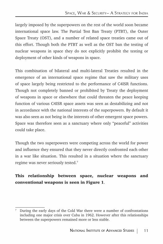
This relationship between space, nuclear weapons and
conventional weapons is seen in Figure 1.
7 During the early days of the Cold War there were a number of confrontations including one major crisis over Cuba in 1962. However after this relationships between the superpowers remained more or less stable.
12 NatioNal iNstitute of advaNced studies
Space, War & Security– a Strategy for india
1.2 From Sanctuary to Contested Ground (1985-1990)
President Reagan’s Strategic Defence Initiative (SDI) also termed as
the Star Wars Programme altered in a fundamental way the status quo
“peaceful “regime in space. A variety of space and other platforms based
on the ground, in air and possibly even in the seas would create the perfect
Ballistic Missile Defence System. This perfect defensive shield would
prevent the delivery of a nuclear payload.
Though there were serious flaws in both the system design and in the
system architecture, SDI set in motion a string of actions and reactions that
destroyed the sanctuary regime in space. By directly connecting the largely
peace-keeping functions of C4ISR with weapons in space and on the earth it
13NatioNal iNstitute of advaNced studies
Space, War & Security– a Strategy for india
changed the nature of space in a fundamental way. From being a sanctuary the
space domain became an arena for contest and conflict. This transformation
created strongly coupled links between space assets and nuclear weapons.
Though never implemented in its totality, the SDI initiative created a number
of Ballistic Missile Defence (BMD) options each of which dealt with parts of
the total BMD solution. It also set in motion actions to counter these BMD
systems resulting in a renewed interest in Anti Satellite (ASAT) weapons and
ASAT capabilities. Nuclear war and a space war thus became more connected.
The Superpower common interest in preserving Space as a sanctuary free of
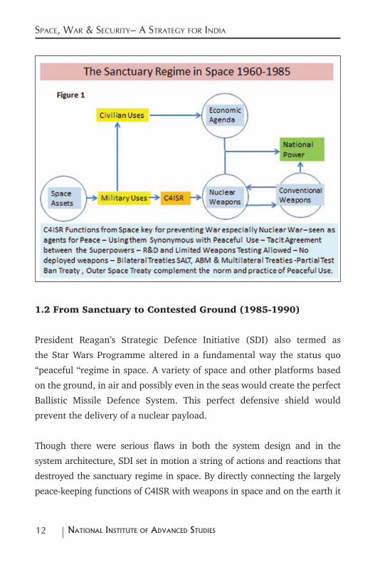
weapons eroded with this renewed competition for dominance. Figure 2
provides a representation of these altered connections between
the uses of space with nuclear and conventional war.
14 NatioNal iNstitute of advaNced studies
Space, War & Security– a Strategy for india
1.3 Space Contest to Space Weapons 1990 Onwards
Two major changes that took place in 1990-91 had a profound impact on the world
and on the world space order. The first Gulf War saw a real life demonstration
of how US Space Power could be used to win a conventional war. US space
based assets especially their C4ISR capabilities directly linked space with the
waging and winning of a conventional war. Space based missile surveillance
capabilities also provided them with the key component of the military
architecture for dealing with Scud missile launches from Iraq. This reinforced
the connections between the use of Space and the waging and winning of a
conventional war. It also brought into visible focus the possible role that BMD
weapons would have on such wars. Space therefore became inextricably linked
not only to nuclear war and nuclear deterrence but also to conventional war and
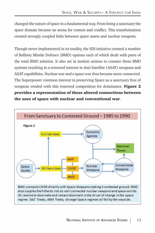
conventional deterrence. Figure 3 provides an overview of the how the
architecture of waging war has changed as a consequence of the
first Gulf War and improvements in civilian capabilities.
15NatioNal iNstitute of advaNced studies
Space, War & Security– a Strategy for india
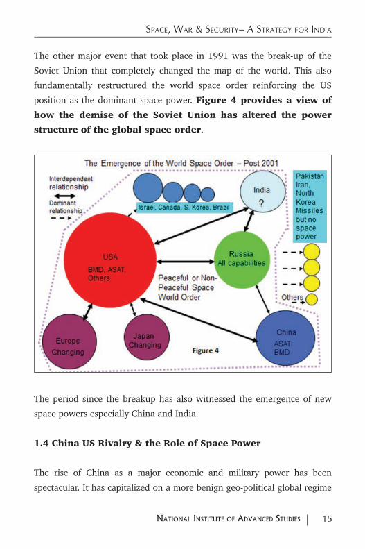
The other major event that took place in 1991 was the break-up of the
Soviet Union that completely changed the map of the world. This also
fundamentally restructured the world space order reinforcing the US
position as the dominant space power. Figure 4 provides a view of
how the demise of the Soviet Union has altered the power
structure of the global space order.
The period since the breakup has also witnessed the emergence of new
space powers especially China and India.
1.4 China US Rivalry & the Role of Space Power
The rise of China as a major economic and military power has been
spectacular. It has capitalized on a more benign geo-political global regime
16 NatioNal iNstitute of advaNced studies
Space, War & Security– a Strategy for india
especially within its neighbourhood to emerge as a likely challenger to the
US.8 This proactive approach also has also witnessed a major shift in strategy
that recognizes the increasingly interdependent relations between space,
nuclear weapons, conventional weapons and conventional war.
The nuclear weapon component of this strategy is based on the assessment
that their second generation nuclear submarines would not be able to
provide an assured retaliatory capability. In order to deter an advanced
adversary such as the US, China has therefore resorted to a deployment
strategy that emphasizes mobility and concealment. By replacing their
large liquid fuelled missiles with much more mobile and ready to use solid
propellant missiles they hope to create enough “first strike uncertainty” in
the minds of the adversary so as to deter them.9
The DF-21, the DF-21A, the DF-31, the DF-31A, the JL-2 SLBM and the DF 41
represent China’s modern missile arsenal that targets the US and its allies.
Their deployment is backed by a nuclear weapons testing programme that
provides a spectrum of warhead yields to deal with different eventualities.
Though it may still be behind the US in terms of capabilities in areas like
miniaturization and MIRV China does have in place a robust retaliatory
capacity that is adequate to deter a nuclear first strike from any adversary
including the US.
8 For an Indian perspective on China’s Rise see S.Gopal & Nabeel Manceri (Editors) “Rise of China Indian Perspectives”, Lancer Publishers & Distributors, 2013. Also see Mayilvaganan et al, “Asia Pacific Power Dynamics: Strategic Implications And Options For India”, Workshop & Seminar Proceedings, http://isssp.in/workshop-report-asia-pacific-power-dynamics-strategic-implications-options-for-india/
9 Wu Riqiang, “The Certainty of Uncertainty: Nuclear Strategy with Chinese Characteristics”, Program On Strategic Stability Evaluation (POSSE) http://posse.gatech.edu/sites/posse.gatech.edu/files/4%20Wu%20POSSEIV.pdf
17NatioNal iNstitute of advaNced studies
Space, War & Security– a Strategy for india
The Chinese nuclear weapons testing programme also include a number of
low yield tests. This would suggest that they also possess tactical nuclear
weapons that can be deployed on their short range DF-11, DF-15 ballistic
missiles as well as on their cruise missiles.
China therefore has in place an array of nuclear weapon capabilities that
covers the tactical, theatre and strategic geographies of engagement.
The signals that they are sending out to the world through testing and
deployment of their nuclear and missile arsenals are consistent with a clear
strategy for deterring nuclear war at several levels.
Though China has land borders with fourteen other countries and a
number of vulnerabilities arising from the geography and history of these
border areas, China’s major concerns have always been associated with
the reclamation of Taiwan. A careful assessment of their nuclear weapons
testing programme, their deployment of military and missile forces across
the Taiwan straits, their demonstration of space weapons capabilities
through an ASAT test and their launch and operation of the Yaogan
constellation of military satellites linked to an ASBM mission10 reveal a
well-crafted carefully thought out strategy for deterring US involvement in
a Taiwan crisis.11
There appears to be two major components to such a strategy.
10 S.Chandrashekar & Soma Perumal, “China’s Constellation of Yaogan Satellites & the Anti-Ship Ballistic Missile: January 2015 Update”, http://isssp.in/chinas-constellation-of-yaogan-satellites-the-asbm-january-2015-update/
11 A recent Rand Study provides some idea of the relative balance of power between the US and China in the event of a conflict over Taiwan. Eric Heginbotham et al, “The US China Military Scorecard Forces, Geography and the Evolving Balance of Power 1996-2017”, Rand Corporation Santa Monica Calif. 2015
18 NatioNal iNstitute of advaNced studies
Space, War & Security– a Strategy for india
The first component is an Anti-Access, and Area Denial capability. The
DF-21C missile with a Kinetic Energy Warhead is an ASAT weapon. It
directly threatens various US C4ISR space assets. These assets are crucial
for waging and winning a conventional war. The other weapon system
that is used for denying area is the ASBM weapon system that has entered
operational status. The ASBM links space based and ground based C4ISR
capabilities with another variant of the DF-21 missile the DF-21D that can
target US Aircraft Carriers in the Pacific Ocean. Together these deployed
weapons threaten US military forces at stand-off distances of around 1700
to 2000 Km. 12
The second component of China’s Taiwan strategy is the element of risk
introduced into the US China dynamic by deploying missiles with very
similar characteristics for both nuclear and conventional war.
The DF-21 and the DF-21A carry nuclear weapons. The DF-21C ASAT and
the DF-21D ASBM are missiles with non-nuclear warheads.
The introduction of these missiles into the Taiwan theatre of operations
substantially raises the risk of a DF-21 with a conventional warhead being
mistaken for a DF-21 or DF 21A nuclear armed missile.
Thus US intervention in a Taiwan crisis not only has to cope directly with the
ASAT and ASBM (Anti-Access and Area Denial) threats it also has to worry
about the fact that the conventional missiles that China may deploy in such
a crisis could be easily mistaken for a nuclear weapon carrying missile. This
would raise the risk of a conventional war escalating into a nuclear war.
12 S.Chandrashekar et al, “China’s Ant Ship Ballistic Missile Game Changer in the Pacific Ocean”, NIAS Report, R5-11 International Strategic & Security Studies Programme (ISSSP), National Institute of Advanced Studies (NIAS) Bangalore, India November 2011.
19NatioNal iNstitute of advaNced studies
Space, War & Security– a Strategy for india
Rather than directly threatening the US and its allies with nuclear weapons
this strategy tries to deter US intervention in a Taiwan crisis by raising the
risk of a conventional war escalating to a nuclear war.
While the Anti-Access and Area Denial strategy with ASAT and ASBM
weapons is aimed at theatre level operations extending to about 2000 Km
from China’s mainland, China also has in place a strategy for dealing with
conflicts at the tactical level in and around the immediate areas surrounding
Taiwan. The DF-11, the DF-15 as well as some of their cruise missiles all carry
conventional warheads. They can also carry nuclear warheads with relatively
low yields and neutron bombs suitable for tactical war. This ambiguity in use
once again raises the risk that a conventional conflict could escalate into a
war with nuclear dimensions.
Through this clever manipulation of risk China hopes to deter the US from
intervening in a conflict over Taiwan at both the theatre and tactical levels. 13
China has also made sure that its theatre and tactical conflict strategies
directed against the US and its allies over Taiwan does not spillover into its
direct dealings with the US on the questions of nuclear and conventional
war. The DF-31, the DF-31A, the JL-2 SLBM and the DF-41 are clearly and
unambiguously meant for carrying nuclear weapons only.
The small size and capabilities of this arsenal are meant both to reassure
the US about its intentions and also to deter a US first strike against China.
This multi-tiered defense oriented strategy anchored in Anti-Access, Area
13 For details of how an array of risk options can be used to raise the risk of a conventional war escalating to a nuclear war see Robert Powell, “Nuclear deterrence theory - The search for credibility” Cambridge University Press 1990, pp. 15-17.
20 NatioNal iNstitute of advaNced studies
Space, War & Security– a Strategy for india
Denial and ambiguity in the tactical and theatre sphere of operations is
consistent with the relatively inferior position of China vis a vis the US in
nuclear, space and conventional capabilities.
The US on its part has recognized these changes in China’s approach to
protecting its interests. Its strategy of pivoting towards Asia is meant to
counter China’s strategy of trying to achieve a dominant position in the
Asia Pacific region.14
It is clear from the above analysis that the nuclear and conventional war
strategies of major powers are intimately connected with the use of space
assets. Therefore strategies for coping with and managing such conflicts
will necessarily involve the development and deployment of weapon
systems that can take care of these assets. The evidence suggests that
the sanctuary regime has been replaced by a new regime where war and
conflict in space maybe a precursor to a more conventional war with riskier
nuclear dimensions. It is in this context that we have to look at the global
space order and assess Indian capabilities and capacities for meeting some
or all of these emerging challenges.
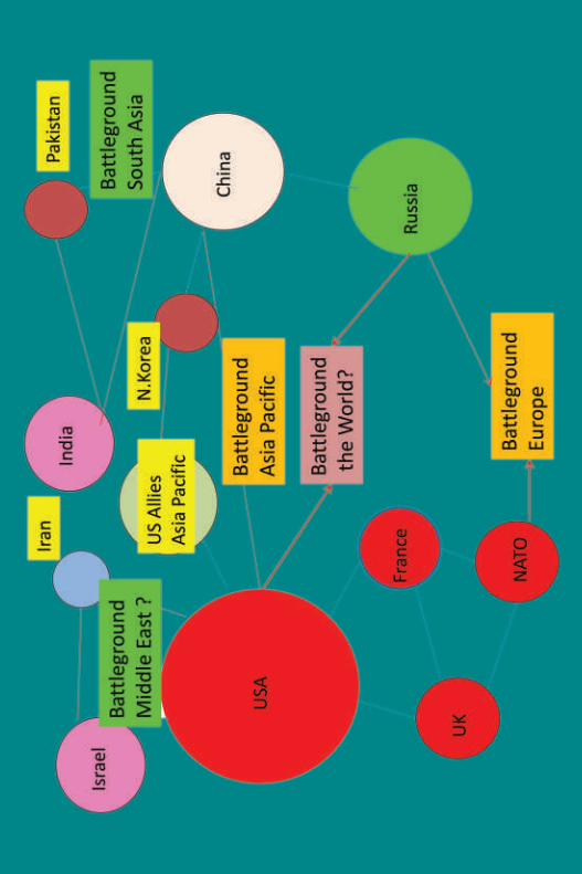
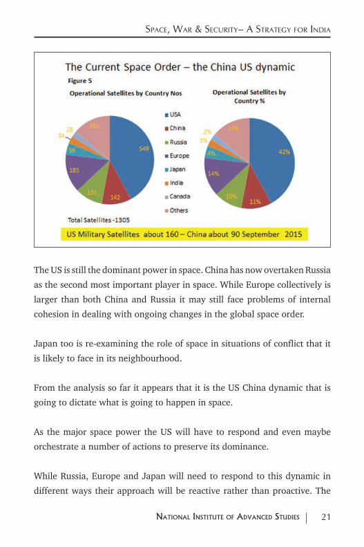
1.5 The World Space Power Structure
Figure 5 build upon the conceptual framework of Figure 4 to
provide a snapshot of the world space order in terms of the
number of satellites that the space powers currently operate.15
14 Ashley J Telis, “Pivot or Pirouette: the US Rebalance to Asia”, available at http://isssp.in/pivot-or-pirouette-the-u-s-rebalance-to-asia-2/
15 Based on data put out by the Union of Concerned Scientists that includes satellite launches up 31st January 2015.at http://www.ucsusa.org/nuclear-weapons/space-weapons/satellite-database.html#.Vgou932rHgI
21NatioNal iNstitute of advaNced studies
Space, War & Security– a Strategy for india
The US is still the dominant power in space. China has now overtaken Russia
as the second most important player in space. While Europe collectively is
larger than both China and Russia it may still face problems of internal
cohesion in dealing with ongoing changes in the global space order.
Japan too is re-examining the role of space in situations of conflict that it
is likely to face in its neighbourhood.
From the analysis so far it appears that it is the US China dynamic that is
going to dictate what is going to happen in space.
As the major space power the US will have to respond and even maybe
orchestrate a number of actions to preserve its dominance.
While Russia, Europe and Japan will need to respond to this dynamic in
different ways their approach will be reactive rather than proactive. The
22 NatioNal iNstitute of advaNced studies
Space, War & Security– a Strategy for india
Russia China relationship and how that will affect US actions could also be
important.
There is also little doubt that space, nuclear weapons, conventional weapons
and strategies of war and deterrence are now inextricably connected with
each other.
For a country like India which is emerging as a space power understanding
these relationships and their impact on the space component of a country’s
capabilities is extremely important.
Though its space assets are smaller than those of the other major powers
they are not insignificant. At the very least they may need to be protected
against the direct and indirect consequences of actions taken by the other
space powers. 16
Given these global trends and developments where the use
of space is linked to both nuclear and conventional war what
actions should India take in order to protect her national
interests. This is the issue that will be addressed in the
subsequent sections of the paper.
16 One estimate placed the value of Indian space assets at 100000 crores. See K.Kasturirangan, “The Emerging World Space Order – An Indian Perspective”, Keynote Address Space Security Conference, November 1-14 New Delhi. For a more rigorous economic evaluation of the benefits of the Indian Space Programme see U.Sankar, “The Economics of India’s Space Programme - An Exploratory Analysis”, Oxford University Press, New Delhi 2007 xiv, p.312
23NatioNal iNstitute of advaNced studies
2.0 indian capacitieS, capaBilitieS & gapS - Space Situational aWareneSS (SSa)
As stated earlier India was not aware of China’s ASAT test till well after
the test. Though information on the orbital parameters of the
Yaogan 9 A, 9 B and 9 C constellation was available in the
public domain Indian establishments were apparently unable
to link these to an ELINT capability.17
These are symptoms of deep rooted problems in Indian capabilities to
monitor and track satellites in orbit around the earth.
The current mix of Indian and foreign ground TT&C stations are adequate
for tracking Indian satellites and space launches that emit radio signals.
However Indian capabilities for tracking inactive satellites
and space debris are extremely limited if not non-existent.
India has invested a fair amount of money in creating a set of space based
assets for a variety of national development tasks. Even if one were to
ignore the military implications of what is happening in space India needs
to protect these assets from risks posed by the exponentially increasing
population of dead satellites and space debris.
India therefore needs to create a suitable network of long
range radars that could track space objects. A network of
optical tracking and laser ranging stations would complement
and enhance the capabilities of the radar network.
17 North American Air Defense (NORAD) Command makes available two line elements of all satellites that enable one to propagate all orbits. See http://www.celestrak.com/NORAD/elements/
24 NatioNal iNstitute of advaNced studies
Space, War & Security– a Strategy for india
Apart from the creation of this infrastructure, India also needs
to identify suitable entities within the National Security complex
that would be responsible for the routine monitoring of the space
environment. These entities could combine openly available information along
with their primary data to provide updates and reports on what is happening in
space and their implications for India. They could also issue warnings to satellite
operators on possible risks arising from debris and inactive satellites.
India also needs to grow the human resource base that is able
to use public domain information to provide independent
assessments of what is happening in space.
These activities are best done within the University or think tank systems.
While there are a number of groups across the country that deal with
the political aspects of nuclear weapons and space activities there are
practically no such groups that deal with the technical details of nuclear or
space issues. This situation needs to be changed.
A deeper study of orbital motions around the earth can also benefit
a number of scientific domains such as geodesy and astronomy.
A strengthening of these aspects at Research Centers and Universities would
create the necessary human resource base needed for the above activities.
Routine monitoring and a deeper understanding of what is
happening in the space environment would be a very high
priority area for an emerging power like India.
25NatioNal iNstitute of advaNced studies
3.0 capacitieS, capaBilitieS & gapS - Space BaSed c4 aSSetS
3.1 The Role of Space Based Assets for Command, Control,
Communications & Computers (C4)
National security systems are complex systems that require a high degree of
specialization. Command, Control and Communications functions are the
glue that bind the various entities so that they work together to execute a
particular strategy. Space based satellite communications systems provide
a robust way of linking such diverse assets and organizations spread out
over a large geographic area.
Developments in technologies such as encryption, frequency hopping and
spread spectrum provide reliable routes for ensuring assured command,
control and communications functions via both dedicated military and
non-dedicated commercial satellites.
Dedicated, advanced communications satellites with multiple reconfigurable
antennae beams operating in the Geo-Stationary Orbit (GSO) and catering
to the C4 requirements of the military will be needed. Some of the required
capacities could also be provided by commercial satellites. These satellites can
cater to both mobile and fixed users and increasingly handle all kinds of digital
data including images and streaming video.
The INSAT series of Geostationary Communications satellites currently provide
these services to users in India including the military. There is therefore a large
base of experience and capabilities in the country. If the National Security
Complex in the country has to move towards a more information oriented
operational capability these capacities may need augmentation.
26 NatioNal iNstitute of advaNced studies
Space, War & Security– a Strategy for india
The launch and satellite record indicate major gaps in capacities to
build, launch and operate these systems. There could also be areas of
technology such as secure communications, encryption, design of multiple
beam satellites, electronically scanned phased array antennae etc., where
available capabilities need to be strengthened.
3.2 GSO - Communications Satellites Indian Capacities,
Capabilities & Trends
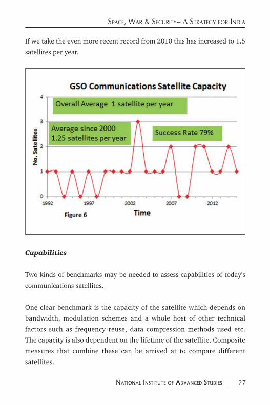
Figure 6 provides an overview of the various Indian built
communications satellites that have been placed in GSO. These
include satellites that have been launched by foreign launchers such as Ariane
as well as by Indian launchers such as PSLV and GSLV Mark 1 & Mark 2.18
Most of these have been launched for meeting civilian needs. Only two
of them the GSAT 7 launched by Ariane in 2013 and maybe the GSAT
6 launched by the GSLV Mark 2 in 2015 may have been dedicated for
military use.
The maximum number of GSO communications satellites launched by
India in any given year is 3 achieved in 2003 with two foreign and one
indigenous GSLV Mark 1 flight.
The satellite record shows an average capacity of 1 GSO satellite per year
over the whole period from 1992 to 2015.
If we take the average from 2000 onwards the average number of satellites
is 1.25 per year.
18 Based on data collated from http://www.isro.gov.in/spacecraft/list-of-commu-nication-satellites
27NatioNal iNstitute of advaNced studies
Space, War & Security– a Strategy for india
If we take the even more recent record from 2010 this has increased to 1.5
satellites per year.
Capabilities
Two kinds of benchmarks may be needed to assess capabilities of today’s
communications satellites.
One clear benchmark is the capacity of the satellite which depends on
bandwidth, modulation schemes and a whole host of other technical
factors such as frequency reuse, data compression methods used etc.
The capacity is also dependent on the lifetime of the satellite. Composite
measures that combine these can be arrived at to compare different
satellites.
28 NatioNal iNstitute of advaNced studies
Space, War & Security– a Strategy for india
In simple terms this can be termed as a capacity measure.
The other important measure is to look at how the capacity is being used
to service users in different locations and the kind of services that can be
provided to them. This depends on the number of beams, the geographical
spread of the beams and the ability to switch between geographies and
different kinds of services.
In simple terms this can be termed as a flexibility measure.
The evolution in capabilities of the satellite such as
communications capacity, providing flexibility in connecting
different regions of the country and even the efficiency of the
use of the radio-frequency spectrum are directly correlated
with the satellite mass. Therefore satellite mass is a useful
surrogate measure to assess the overall evolution of the
capabilities of the satellite.
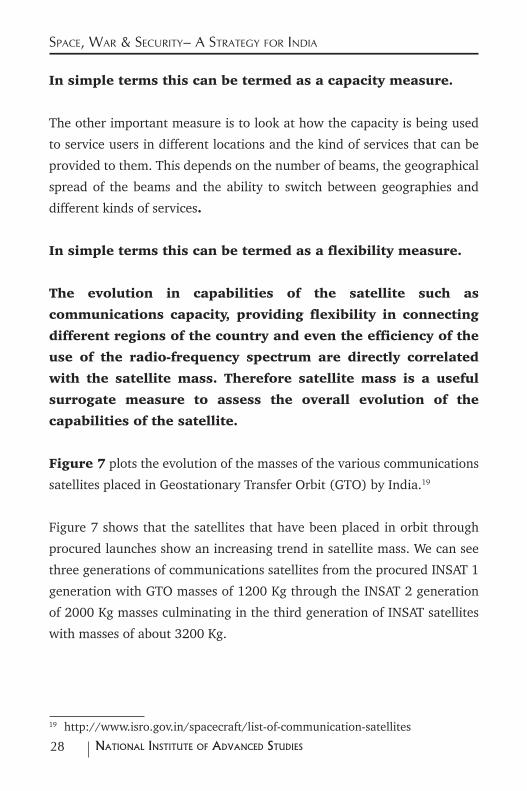
Figure 7 plots the evolution of the masses of the various communications
satellites placed in Geostationary Transfer Orbit (GTO) by India.19
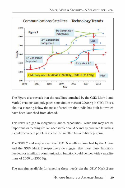
Figure 7 shows that the satellites that have been placed in orbit through
procured launches show an increasing trend in satellite mass. We can see
three generations of communications satellites from the procured INSAT 1
generation with GTO masses of 1200 Kg through the INSAT 2 generation
of 2000 Kg masses culminating in the third generation of INSAT satellites
with masses of about 3200 Kg.
19 http://www.isro.gov.in/spacecraft/list-of-communication-satellites
29NatioNal iNstitute of advaNced studies
Space, War & Security– a Strategy for india
The Figure also reveals that the satellites launched by the GSLV Mark 1 and
Mark 2 versions can only place a maximum mass of 2200 Kg in GTO. This is
about a 1000 Kg below the mass of satellites that India has built but which
have been launched from abroad.
This reveals a gap in indigenous launch capabilities. While this may not be
important for meeting civilian needs which could be met by procured launches,
it could become a problem in case the satellite has a military purpose.
The GSAT 7 and maybe even the GSAT 6 satellites launched by the Ariane
and the GSLV Mark 2 respectively do suggest that most basic functions
needed for a military communication function could be met with a satellite
mass of 2000 to 2500 Kg.
The margins available for meeting these needs via the GSLV Mark 2 are
30 NatioNal iNstitute of advaNced studies
Space, War & Security– a Strategy for india
still very thin. To meet many current operational functions additional mass
may definitely be needed.
Therefore accelerating the development and operationalization of the GSLV
Mark 3 four tonne (4000 Kg) class launcher becomes a crucial component of
the Indian space strategy especially for meeting military needs.
Global Trends & India’s Position
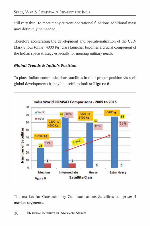
To place Indian communications satellites in their proper position vis a vis
global developments it may be useful to look at Figure 8.
The market for Geostationary Communications Satellites comprises 4
market segments.
31NatioNal iNstitute of advaNced studies
Space, War & Security– a Strategy for india
These are:
• Medium category satellites whose mass in GTO is less than 2500 Kg;
• Intermediate class satellites with GTO mass of 2500 - 4200 Kg
• Heavy satellites with masses in GTO between 4200 and 5400 Kg;
• Extra Heavy satellites with masses in GTO that is greater than 5400 Kg.
The WGS series of US Defence satellites have a launch mass of about 6000
Kg.20 One of the largest capacity commercial communications satellite is
Viasat. This has a launch mass of about 6700 Kg.21 The overall trends
both in the civilian and military domain suggest a move away from the
medium and intermediate category towards the heavy and extra heavy
categories.22
Indian Communications satellites that have been launched by foreign
launchers like Ariane fall in the intermediate category. Indian
Communications satellites that have been launched by the indigenous
GSLV launcher fall in the medium satellite category. This relative
positioning of Indian satellites vis a vis world trends suggests that
Indian capabilities for Communications satellite manufacture has to
grow from the intermediate class towards the heavy and extra heavy
categories.
20 Wideband Global Satcom (WGS) is a US led global advanced satellite system with a number of participating countries. A constellation of advanced communications satellites provide global connectivity for all military operations. Australia, Canada, Denmark, Luxembourg, Netherlands and New Zealand are part of this global system. See http://www.afspc.af.mil/library/factsheets/factsheet.asp?id=5582
21 http://www.nasaspaceflight.com/2011/10/ils-proton-m-launch-highest-throughput-satellite-viasat-1/
22 For an overview of these trends in satellite masses see Federal Aviation Administration, “The Annual Compendium of Commercial Space Transportation: 2014”, February 2015, PP 100-104 available at https://www.faa.gov/about/office_org/headquarters_offices/ast/media/FAA_Annual_Compendium_2014.pdf
32 NatioNal iNstitute of advaNced studies
Space, War & Security– a Strategy for india
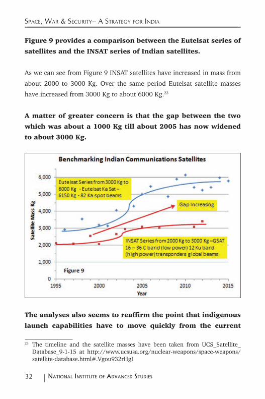
Figure 9 provides a comparison between the Eutelsat series of
satellites and the INSAT series of Indian satellites.
As we can see from Figure 9 INSAT satellites have increased in mass from
about 2000 to 3000 Kg. Over the same period Eutelsat satellite masses
have increased from 3000 Kg to about 6000 Kg.23
A matter of greater concern is that the gap between the two
which was about a 1000 Kg till about 2005 has now widened
to about 3000 Kg.
The analyses also seems to reaffirm the point that indigenous
launch capabilities have to move quickly from the current
23 The timeline and the satellite masses have been taken from UCS_Satellite_Database_9-1-15 at http://www.ucsusa.org/nuclear-weapons/space-weapons/satellite-database.html#.Vgou932rHgI
33NatioNal iNstitute of advaNced studies
Space, War & Security– a Strategy for india
GSLV Mark 2 with a two tonne GTO capability towards at least
a four tonne class GSLV Mark 3. There also appears to be a
need to also move towards a 6000 Kg GTO capability. Ways and
means to redress the ever widening gap in satellite capacities
and capabilities is therefore a high priority for India.24
3.3 The Promise of Ion Propulsion for Reducing Satellite Mass
One major technology development that shows promise in reversing the
trend towards heavier satellites has been recently introduced into the
communications satellite market by Boeing.
It is a well-known fact that over half the mass of a typical Geostationary
Communications satellite is made up of propellant. Most of this propellant
is consumed in moving the satellite from GTO to GSO.
Ion propulsion provides an alternative way of providing the thrust required
to move a satellite from GTO to GSO. It involves the acceleration of ions
typically xenon ions through an electric cum magnetic field and pushing it
out through a suitable exit. Though ion thrusters have high specific impulse
the thrust levels they provide are much lower than chemical propellants.
As a consequence of this the time taken to go from GTO to GSO will
take several months and if the satellite is heavy even longer. Chemical
24 The space programme seems to be aware of this gap. It has floated a tender for the supply of a 6 tonne, Ka band communications satellite from global vendors. See http://www.thehindu.com/news/national/isro-eyes-a-6tonne-k-band-satellite/article4134039.ece. The 2014-15 Annual Report of the Department of Space has an entry for GSAT 11 that states, “GSAT-11 is an advanced communication satellite employing a new class of bus weighing 4000-6000 kg. The payload includes Ka x Ku-band Forward Link Transponders and Ku x Ka-band Return Link Transponders. Subsystem fabrication activities are in various stages of completion. A detailed qualification programme is in an advanced stage of completion.”
34 NatioNal iNstitute of advaNced studies
Space, War & Security– a Strategy for india
propellants on the other hand may have lower specific impulse but provide
a much higher level of thrust than ion propulsion. The journey from GTO
to GSO therefore takes only days instead of months.
However the major gain from the use of ion propulsion is that the amount
of propellant carried by the satellite that typically accounts for at least half
the satellite mass can be more or less eliminated. Though ion propulsion
also requires some mass it is significantly lighter than the heavy chemical
propulsion systems that spacecraft carry. Current thinking that has been to
some extent substantiated by practice suggests that this trend may become
more pronounced in the next few years. 25
In early March 2015 the first two all ion propulsion satellites were launched
aboard a Falcon X launcher. The two satellites were both built by Boeing.
The Asia Broadcast Satellite 3A (ABS 3A) weighed 1954 Kg with 24 C and
24 Ku band transponders.26 The second satellite was the Eutelsat 115 W B
satellite with a mass of 2205 Kg carrying 34 Ku and 12 C band transponders.27
Because of the significant weight saving arising from the use of ion propulsion
for moving the satellite from GTO to GSO they could be accommodated for a
dual launch on the Falcon X. This reduced the launch cost significantly making
the transition to an all ion propulsion approach economically attractive.
Both satellites are currently in the process of moving from GTO to GSO.
This orbit raising operation using Boeing patented technology may take
about 8 months to complete.
25 For details see Stephen Clark, “Boeing’s first two all-electric satellites ready for launch”, Spaceflight Now March 1 2015.
26 http://www.aerospace-technology.com/projects/abs-3a-communication-satellite/
27 http://space.skyrocket.de/doc_sdat/eutelsat-115-west-b.htm
35NatioNal iNstitute of advaNced studies
Space, War & Security– a Strategy for india
A similar satellite built by India that carried 36 C & extended C band
transponders with 12 Ku band transponders the GSAT 16 launched in 2014
weighed 3182 Kg.
Ion propulsion therefore provides one way in which the gap in launcher
capacity can be bridged. If the third generation communications satellites
currently being built can be converted into satellites that use ion propulsion
resulting in a significant reduction in the mass of the satellite they can
be accommodated on the GSLV Mark 2 launcher. The fourth generation
intermediate class satellites with GTO masses of 4000 Kg that could be
launched by the GSLV Mark 3 can perform like the current heavy class
satellites if they can be launched with ion propulsion.
This route to improving indigenous capability is not without its share of
problems. Though work on ion propulsion has been going on for some
time indigenous capabilities may still not be enough to meet the needs.
The long time taken to move from GTO to GSO can also raise the risk of
something going wrong. In spite of these issues the ion propulsion route
at least provides one way for bridging the launcher and satellite gaps that
exist for meeting strategic needs.
3.4 Indian GSO C4 Needs
While the use of ion propulsion will reverse the trend towards heavier
satellite to some extent it will not completely eliminate the technical logic
for building heavier satellites. The need for large capacities coupled with
the need to make this capacity available to a multitude of users across
different geographies will definitely demand heavier payloads even with
ion propulsion. This is a trend that is common to meeting both civilian
and military needs.
36 NatioNal iNstitute of advaNced studies
Space, War & Security– a Strategy for india
The immediate requirement from an Indian point of view is to accelerate
the development of the GSLV Mark 3 launcher that will raise the satellite
mass in GTO to about 4000 Kg. Even with ion propulsion such masses may
be needed if India has to match global trends.
Whether India may need an even bigger launch capability than the GSLV Mark
3 for catering to the Communications needs of the country will depend on
how the experience with ion propulsion unfolds in the next few years.28 There
is also a possibility that as satellites get heavier they may need to revert to
standard chemical propulsion for operational reasons. These considerations
may dictate a larger launch capability than that provided by the GSLV Mark 3.
The C4 needs of the Indian Armed Forces can be possibly met with one
large satellite shared by all the services or separate satellites dedicated to
each service.
Constraints both from both the satellite building as well from the launcher
side may dictate smaller satellites.
Assuming that each service may need a dedicated system a minimum of
three operational satellites with one spare in orbit may be needed.
Since the systems may need to be become operational soon all of them may
be needed to be launched within a two year period.
Thus a minimum capacity of two Communications Satellites and two
launchers per year may be needed to meet domestic military needs.
28 The use of ion propulsion for reducing the satellite mass has been talked about by ISRO too. See comments of K.Sivan Director Liquid Propulsion Systems Centre in Dennis J. Jesudasan, “ISRO navigation satellite in orbit”, The Hindu March 28, 2015.
37NatioNal iNstitute of advaNced studies
Space, War & Security– a Strategy for india
The current civilian requirement is about 1.5 satellites per year and is likely
to grow.29
A total capacity of 4 GSO Communications satellites along with
their associated launchers may be needed in all for meeting
military and civilian needs. This capacity will cater to a peak demand.
Surplus capacity available during the lean period could be used for building
satellites to cater to the export market or for meeting other GSO needs
such as weather or navigation services.
This expansion of the military component of GSO communications capacity
may also need suitable orbital slots and spectrum in the Geostationary Orbit.
This aspect should also be kept in mind in formulating the country’s strategy.
3.5 A New Trend –Small Satellite Constellations for C4 needs
Constellations of satellites in Low Earth Orbits could also provide connectivity.
The Soviet era Strela satellite constellation that could store and forward
various kinds of data has been around for a fairly long period of time.30
The commercial world has also seen the emergence of a number of LEO
constellations such as ORBCOM, and Globalstar that provide a variety of
communications services. Most of them do not operate on direct satellite
to satellite links but use suitably located ground stations to route the data
29 Available evidence from the ground suggests that there is a lot of unmet demand for transponders over India. Many TV channels in India for e.g. use transponders on foreign satellites
30 http://www.russianspaceweb.com/strela_comsat.html
38 NatioNal iNstitute of advaNced studies
Space, War & Security– a Strategy for india
via satellite to the required destination.31
The Iridium constellation of 66 satellites was the first orbiting satellite
based communication system that used satellite to satellite switching and
communications technologies for providing global coverage.32
O3b is an operational system that uses 12 satellites operating in an 8063
Km orbit above the equator to provide high speed internet connectivity
to users between 45 N Latitude and 45 S Latitude. It uses 12 Ka band
steerable antennae along with a network of suitably located gateway
stations to provide the required connectivity. Each of the satellites weighs
about 700 Kg. The constellation provides a combined capacity of about 100
Gigabits per second. They are launched four at a time by Ariane’s Soyuz
launcher from Kourou in French Guyana.33
More recently a number of new start-up companies such as OneWeb are
proposing to launch large constellations of small satellites for providing
global broad band Internet connectivity via satellite to satellite networks.
The constellation proposed by OneWeb will have 650 satellites orbiting in
20 different planes at altitudes of 800 and 950 Km. Airbus Defence & Space
has been selected as the contractor to roll out the satellites. The satellites
which are expected to weigh about 175 to 200 Kg will be launched 32 to
31 For an overview of LEO satellite systems that covers most of the current systems see Christopher Redding, “Overview of LEO Satellite Systems”,1999 International Symposium on Advanced Radio Technologies, at http://www.its.bldrdoc.gov/media/30329/red_abs.pdf
32 Kris Maine et al “Overview of Iridium Satellite network,”WESCON/’95. Conference record. ‘Microelectronics Communications Technology Producing Quality Products Mobile and Portable Power Emerging Technologies’ available at http://ieeexplore.ieee.org/stamp/stamp.jsp?arnumber=485428
33 http://www.o3bnetworks.com/technology/
39NatioNal iNstitute of advaNced studies
Space, War & Security– a Strategy for india
36 at a time on board an Ariane Soyuz launcher.34
The satellites operate in the Ku Band for which the company has a licence.
The design of the satellite is such that interference with the Ku band
transmissions of GSO satellites are within acceptable limits.
The satellites use phased array antenna with each satellite having a capacity
of about 8 Gigabits per sec.
The satellites connect to users through a small terminal that connects to all
users using standard radio frequencies used for mobile services. Thus cell
phones, laptops and tablets can be directly connected to the Internet via
these terminals. These can be added suitably to existing mobile networks
to directly connect to the Internet.
These developments suggest that constellations of small satellites in low
and medium altitude orbits can provide services for meeting both routine
as well as crisis mode operations.
These could be dedicated to military use or could be a part of a dual use
network.
India has so far no experience with orbiting constellations of communications
satellites. As is the case with ISR functions the trend seems to be towards
building smaller satellites and launching them more frequently.
One reasonably large constellation of orbiting satellites needs to be
34 http://spaceflightnow.com/2015/07/01/oneweb-launch-deal-called-largest-commercial-rocket-buy-in-history/
40 NatioNal iNstitute of advaNced studies
Space, War & Security– a Strategy for india
designed, built and launched within the next two or three years to keep
future options open for the country. Both civilian and military needs can be
met through the creation of this capability.
A constellation of about 40 satellites in a suitable LEO orbit
that provides coverage over the Asia Pacific region may be
the first step that India needs to take in being able to come
to terms with this emerging technology system. The satellites
whose masses can be in the range of 150 to 200 Kg can be
launched three or four at a time by the PSLV launcher.
In terms of capacities and assuming a two year period for the creation of
the constellation this would translate into a capacity of 20 small satellites
per year along with 5 launches of the PSLV vehicle.
A key requirement for an efficient operational C4 network would be the
need to integrate the space part of the network which may include both
geostationary and orbiting satellites with other modes of connection such
as wireless and fiber optics.
Clearly a space strategy for the country should address these gaps in
capabilities and capacities.
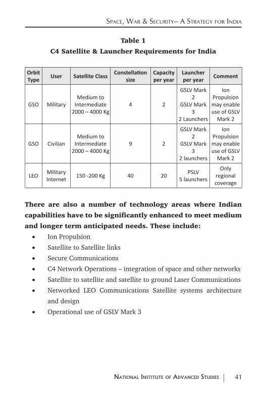
3.6 Overall Requirements of C4 Capabilities
Table 1 summarizes the C4 satellite and launcher requirements for meeting
both civilian and military needs.
41NatioNal iNstitute of advaNced studies
Space, War & Security– a Strategy for india
Table 1
C4 Satellite & Launcher Requirements for India
Orbit Type
User Satellite ClassConstellation
size Capacity per year
Launcher per year
Comment
GSO MilitaryMedium to
Intermediate 2000 – 4000 Kg
4 2
GSLV Mark 2
GSLV Mark 3
2 Launchers
Ion Propulsion may enable use of GSLV
Mark 2
GSO CivilianMedium to
Intermediate 2000 – 4000 Kg
9 2
GSLV Mark 2
GSLV Mark 3
2 launchers
Ion Propulsion may enable use of GSLV
Mark 2
LEO Military Internet 150 -200 Kg 40 20 PSLV
5 launchers
Only regional coverage
There are also a number of technology areas where Indian
capabilities have to be significantly enhanced to meet medium
and longer term anticipated needs. These include:
• Ion Propulsion
• Satellite to Satellite links
• Secure Communications
• C4 Network Operations – integration of space and other networks
• Satellite to satellite and satellite to ground Laser Communications
• Networked LEO Communications Satellite systems architecture
and design
• Operational use of GSLV Mark 3
42 NatioNal iNstitute of advaNced studies
4.0 capacitieS capaBilitieS & gapS - Space BaSed iSr
4.1 Global Trends in Intelligence Surveillance & Reconnaissance (ISR)
The Third area that needs a more detailed scrutiny is the realm of
Intelligence, Surveillance & Reconnaissance (ISR).
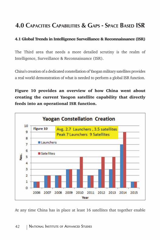
China’s creation of a dedicated constellation of Yaogan military satellites provides
a real world demonstration of what is needed to perform a global ISR function.
Figure 10 provides an overview of how China went about
creating the current Yaogon satellite capability that directly
feeds into an operational ISR function.
At any time China has in place at least 16 satellites that together enable
43NatioNal iNstitute of advaNced studies
Space, War & Security– a Strategy for india
it to monitor military activities in any part of the world in near real time.
These comprise three ELINT clusters of three satellites each, 5 SAR satellites that
provide all weather, day night coverage, 4 high resolution Electro-optical satellites
and another 4 medium resolution electro-optical satellites that have large area
coverage. The 3500 Km broad area coverage provided by an ELINT cluster cues
the optical and SAR satellites to locate identify and track objects of interest.35
A typical ELINT cluster consists of three satellites that are placed in a
special 63.4 degree inclination orbit. The three satellites form a triangle in
which the spacing between them is known.
Each of the satellites is equipped with a wide band receiver that is able to
receive electronic emissions from various objects of interest on the surface
of the earth. The same signal is received by the three satellites at different
times. Using the time difference in the reception and the spacing between
the three satellites the location of the emitting object can be fixed.
The launch and establishment of the Yaogan 9 A, 9 B and 9 C cluster in
2010 signaled China’s entry into an elite group of countries that have
operational ELINT systems. Currently China has at least three different
ELINT clusters that are suitably spaced in orbit so as to provide it with an
operational global ELINT capability.36 A recent launch of the US provides
35 See S.Chandrashekar & Soma Perumal, “China’s Constellation of Yaogan Satellites & the Anti-Ship Ballistic Missile: January 2015 Update”, http://isssp.in/chinas-constellation-of-yaogan-satellites-the-asbm-january-2015-update/
36 For a detailed description of the ASBM system and the role of space assets see S.Chandrashekar et al, “China’s Ant Ship Ballistic Missile Game Changer in the Pacific Ocean”, International Strategic & Security Studies Programme (ISSSP), National Institute of Advanced Studies (NIAS) Bangalore, India November 2011.
44 NatioNal iNstitute of advaNced studies
Space, War & Security– a Strategy for india
an indication of the current capabilities of the US.37
4.2 Indian Remote Sensing Satellite Capacities Capabilities & Trends
Capacities
India has in place a complement of remote sensing satellites equipped with
both Synthetic Aperture Radar (SAR) and Electro-Optical (EO) imaging
sensors. These are currently meant largely for meeting civilian needs.38
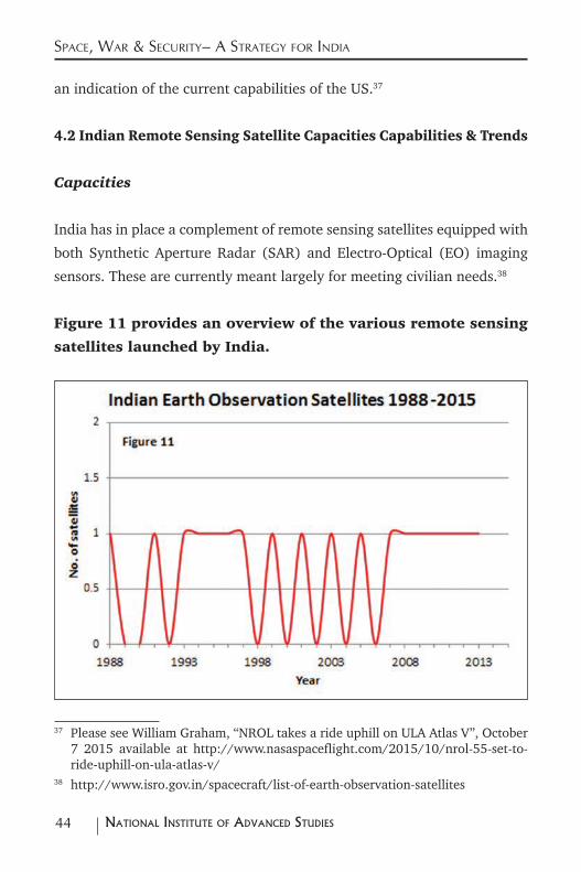
Figure 11 provides an overview of the various remote sensing
satellites launched by India.
37 Please see William Graham, “NROL takes a ride uphill on ULA Atlas V”, October 7 2015 available at http://www.nasaspaceflight.com/2015/10/nrol-55-set-to-ride-uphill-on-ula-atlas-v/
38 http://www.isro.gov.in/spacecraft/list-of-earth-observation-satellites
45NatioNal iNstitute of advaNced studies
Space, War & Security– a Strategy for india
Starting from 1988 with the launch of IRS 1A India has so far launched 18
indigenously built remote sensing satellites.
Currently Resourcesat 1 & 2, Cartosat 1, 2, 2A & 2B, Oceansat 2 and Risat
1 are the indigenous satellites that provide operational services.
Risat 1 was the first indigenously built SAR satellite that India launched in
2012. Indian users also have access to data from Risat 2 a foreign built SAR
satellite that was launched by PSLV.
From Figure 11 it is clear that current Indian capacities for building earth
observation satellites for meeting civilian needs is about 1 satellite per year.
Associated with this is also a PSLV launcher demand of one launch per year.
Indian Remote Sensing Satellite Capabilities - Trends
The key requirements for making comparisons relevant for the military
domain are the spatial, spectral resolutions of the satellites. A related
capability is whether the spatial and spectral capabilities are provided in
one instrument or through several instruments. The mass of the satellite
for achieving a certain spatial and spectral resolution capability is also a
relevant parameter
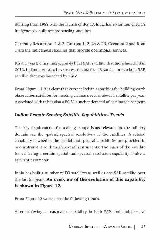
India has built a number of EO satellites as well as one SAR satellite over
the last 25 years. An overview of the evolution of this capability
is shown in Figure 12.
From Figure 12 we can see the following trends.
After achieving a reasonable capability in both PAN and multispectral
46 NatioNal iNstitute of advaNced studies
Space, War & Security– a Strategy for india
capability through the launch of IRS 1D in 1997 India has chosen to separate
out the hi-spatial resolution Panchromatic capability from the multispectral
capability and provide them through different satellite platforms.
The Resourcesat series provides multispectral imagery whilst the Cartosat
series provides Panchromatic imagery.
In terms of multispectral capabilities starting with a resolution of 36 m in
the first generation IRS satellites launched in 1988 India quickly moved
into a multispectral resolution of about 6 m by 1995. During the 1995 to
2000 time frame Indian civilian resolution was possibly the best in the
world. From 6 m India progressed to a multispectral resolution of about
3 m by 2005. This is reasonably close to the current global standard for
multispectral data.
47NatioNal iNstitute of advaNced studies
Space, War & Security– a Strategy for india
As far as Panchromatic imaging is concerned starting from a resolution of
about 3 m in 2005 India achieved a 1 m Panchromatic resolution through
Cartosat 2 launched in 2007.39 This capability is comparable to the best in
the world today.
The first indigenously built RISAT 1 SAR satellite was launched in 2012.40
The highest resolution provided by the SAR in this satellite is about 3 m.
Though adequate for meeting most operational needs this may be below
the global state of art of 1 m resolution in the spotlight mode.
From a functional point of view optical imaging capabilities via separate
multispectral and PAN platforms are reasonably close to the current world
standard. These may also be adequate to cater to most of the ISR functions.
Globally however both PAN and multispectral imageries are provided from
the same set of sensors on one platform. Whether India needs to go this
route from the operational point of view is one consideration to keep in
mind for meeting military needs.
4.3 Benchmarking Indian Remote Sensing Satellites
Benchmarking EO Imaging Satellites
To provide typical benchmarks for assessing Indian capabilities it may be
worthwhile to look at one recent example that also has a strong Indian
connection.
On July 10 2015 the PSLV Launcher placed a constellation of three identical
39 http://www.isro.gov.in/sites/default/files/pdf/pslv-brochures/PSLVC7.pdf 40 http://www.isro.gov.in/sites/default/files/pdf/pslv-brochures/PSLVC19.pdf
48 NatioNal iNstitute of advaNced studies
Space, War & Security– a Strategy for india
DMC3 remote sensing satellites built by Surrey Satellite Technology Limited
(SSTL) into a 647 Km 98.06 degree inclination sun synchronous orbit.
Each of these 447 Kg satellites carried an advance electro-optical imaging
instrument that can provide 4m multispectral imagery in four bands as
well as a 1 m PAN image.
The satellites are spaced 120 degrees apart in the orbit plane so as to be
able to image any target area at least once in a day. The satellites do not
carry chemical propellants for attitude and orbit control. They use a xenon
thruster for this purpose. The entire imaging capacity of this three satellite
constellation has been bought by a Chinese company called 21st Century
Aerospace Technology Company which most probably will sell parts of this
capacity to various users both in China as well as elsewhere in the world.41
If we use this as a bench mark it would appear logical to integrate the
multispectral as well as PAN imaging functions into one payload. The
overall weight of the satellite that performs this combined function should
be around 450 Kg.
Current Indian satellites that provide PAN one metre imagery weigh around
700 Kg. Indian remote sensing that provide multispectral imagery with about
3 m resolution also carry other optical imaging payloads for many other
civilian applications. These multiple camera satellites weigh around 1200 Kg.
Even after accounting for differences because of these configuration issues
there are still significant gaps in terms of technology between the SSTL
benchmark and Indian satellites. One reason for this difference could come
about simply from the use of ion propulsion in the SSTL built satellites versus
the use of conventional chemical propulsion systems on the Indian satellites.
41 http://www.isro.gov.in/sites/default/files/pdf/pslv-brochures/PSLV-C28.pdf
49NatioNal iNstitute of advaNced studies
Space, War & Security– a Strategy for india
Though functionally Indian satellite capabilities are comparable to state of
art they appear to be heavier than current world standards.
There may also be a need to integrate both hi resolution PAN imagery
with lower resolution multispectral imagery in one camera system from the
operational convenience point of view.
These areas need to be addressed through a major technology effort so that Indian
satellites can meet global benchmarks both in function as well as in weight.
One other area of special concern for meeting military needs
relates to the use of the infrared or thermal bands for imaging
applications.
Though the INSAT weather instruments use thermal bands for weather
monitoring these bands are not used on any of the imaging instruments
carried by Indian orbiting remote sensing satellites. Imported discrete
detectors may be used for the IR channels of the GSO weather
satellites. Trends in detectors seem to be moving towards use
of arrays and mosaics. Detectors need to be cooled for efficient
operation. Location of the cooler to ensure proper functioning
of the detector and the imaging instrument is also a challenge.
This is an area where India could become vulnerable to
embargos and control regimes. Infrared detectors, active
cooling systems and spacecraft architectures are therefore
particular areas that may require national attention.
Benchmarking SAR satellites
India launched its first SAR satellite in 2012. The satellite mass of 1858 Kg
50 NatioNal iNstitute of advaNced studies
Space, War & Security– a Strategy for india
was one of the heaviest satellites put into orbit by the PSLV. The onboard
satellite propulsion system was used to raise the initial PSLV orbit of
480 Km to the final altitude of 536 Km needed for the mission. The SAR
operates in the C band.42
Though the overall capabilities of the Indian built SAR payload is very
similar to those offered by other advanced space powers, it does not operate
in the high resolution spotlight mode. It offers a strip map resolution of 3
m that is comparable to those offered by other satellites.
In terms of weight a useful benchmark for the Indian SAR satellite could be
the capabilities of the Indian bought Risat 2 SAR satellite.43 This satellite
weighs 300 Kg provides all modes of SAR operation from the very high
1 m resolution spot light mode through the lower resolution strip map
mode into the coarse resolution scan SAR mode. Though the frequencies of
operation of the indigenous Risat 1 and the bought out Risat 2 are different
this comparison suggests that Indian built SAR satellites are much heavier.
For comparison Chinese built SAR satellites weigh about 2200 Kg44 the
Italian built Cosmo Skymed X band SAR satellite weighs 1700 Kg, the
German Terra SAR X band satellite weighs 1230 Kg and the Canadian
Radarsat 2 weighs about 2200 Kg.45 By these standards which are of 2007
vintage Indian capabilities are not too far from other those of some of the
more advanced countries.
42 http://www.isro.gov.in/sites/default/files/pdf/pslv-brochures/PSLVC19.pdf 43 http://www.isro.gov.in/Spacecraft/risat-2 44 The capacity of the Long March CZ 2C or CZ 4B that have been used is about
2100 Kg to 2200 Kg in Sun Synchronous orbit.45 http://www.ucsusa.org/nuclear-weapons/space-weapons/satellite-database.
html#.Vgou932rHgI
51NatioNal iNstitute of advaNced studies
Space, War & Security– a Strategy for india
From an ISR point of view the day night and all weather capabilities of SAR
instruments on orbiting satellites are very important. Current capabilities
may be adequate for meeting most of the needs. However some effort has
to be made to reduce the mass of the satellites. Once again ion propulsion
could play a major part in bringing down weights.
4.4 Small Satellite Constellations
An emerging trend that could play a big role in the performance of the ISR
function is the growing importance of high quality imagery available from
small satellite constellations launched by a number of private companies
across the world.
Planet Laboratories a San Francisco based start-up company provides 3
m resolution colour imagery. It plans to provide a complete picture of the
earth every day using images produced by more than 100 small satellites.
These satellites weigh around 5 Kg and are launched as constellations into
earth orbits of various inclinations.
Built out of low cost off the shelf components and launched in numbers
they promise to provide an image of the entire planet every day.
Two major flocks of satellites have been launched. The first Flock of
satellites was deployed from the International Space Station and orbits the
earth at an altitude of about 400 km with an inclination of 52 degrees. The
second Flock is in a 620 Km Sun Synchronous Orbit.
About 99 small Dove satellites have been launched by this company. As of
March 2015 about 20 of them are operational. The quality of the images
provided by these satellites is quite good and may be adequate to cater to

52 NatioNal iNstitute of advaNced studies
Space, War & Security– a Strategy for india
many possible military applications as well.46
Skybox Imaging another US start-up recently bought by Google promises
to provide very high resolution data and video from a constellation of
satellites. The first two satellites of a planned constellation of 24 satellites
Skysat 1 and Skysat 2 have already been launched. A PSLV launcher is
also reported to launch future satellites for this company. The satellites are
three axis stabilized and currently weigh around 83 Kg. Both of them have
been launched as a part of a multiple satellite launch by the Dnepr and
Soyuz / Fregat launchers from Russia.
Skysat 1 and Skysat 2 are in 578 Km and 635 Km sun synchronous orbits.
They currently do not have onboard propulsion capabilities. Future versions
will have them. They are likely to be ion propulsion modules. The first two
satellites were built in-house by the company. Future satellites will be built
by Space Systems Loral. 47
The quality of the images from these satellites has also been evaluated.
Their utility for use in a variety of applications including military ones
appears to be good.48
These are just two examples of the many initiatives taken by the global
space industry to make available high resolution imagery on a real time
46 See presentation by Mike Safayan, “Overview of the Planet Labs Constellation of Earth Imaging Satellites – In Space to Help Life on Earth” at http://www.itu.int/en/ITU-R/space/workshops/2015-prague-small-sat/Presentations/Planet-Labs-Safyan.pdf
47 https://directory.eoportal.org/web/eoportal/satellite-missions/s/skysat 48 Pablo d’Angelo et al “Evaluation of Skybox Video and Still Image Products”,
The International Archives of the Photogrammetry, Remote Sensing and Spatial Information Sciences, Volume XL-1, 2014, ISPRS Technical Commission I Symposium, 17 – 20 November 2014, Denver, Colorado, USA, pp 95-99.
53NatioNal iNstitute of advaNced studies
Space, War & Security– a Strategy for india
basis. With the removal of restrictions on the commercial use of sub-meter
resolution satellite images by the US Department of Commerce recently,
high resolution images will become even more freely available.49
While dedicated military satellites will still be needed for some functions,
small civilian satellites could significantly enhance and complement these
military functions. The current heavy custom build ISR satellites could
also be eventually replaced by smaller satellites that provide the same
performance. However these capabilities are not likely to emerge on their
own in a country like India. They need to be nurtured and grown through
a carefully orchestrated national effort that involves both the government
and Indian industry.
An experimental effort with a constellation of 24 satellites of the 100 to
150 Kg class may be needed to give a fillip to national activities in this area.
This would require a capacity to build about 8 small satellites per year in
order to create a constellation over the next three years. These satellites
could be launched four or six at a time by the PSLV. A total of six launches
of the PSLV or two launches per year may be needed for this purpose.
4.5 Role of Open Source Data
Capacity bottlenecks do not exist only in launchers and satellites.
The supply of data from dedicated military satellites as well as from a
number of openly available sources will create a supply overload and open
up a vast pool of various application possibilities.
49 See Warren Fester, “US Government Eases Restrictions on DigitalGlobe”, June 11 2014, at http://spacenews.com/40874us-government-eases-restrictions-on-digitalglobe/
54 NatioNal iNstitute of advaNced studies
Space, War & Security– a Strategy for india
These ISR functions have to be suitably integrated with a variety of military
operations and intelligence functions within the national security complex.
The current human resource base as well as the needed capacities to
assimilate and deal with these large quantities of data may need to be
augmented significantly if this purpose has to be achieved. This requires a
major organizational restructuring and human capacity building exercise.
4.6 Indian Intelligence Surveillance & Reconnaissance (ISR) Needs
From Figure 10 which depicts China’s experience with the Yaogan
series of military satellites a capacity to build 6 satellites per year
along with a launch capacity of three launchers appears to be needed
if India is to be able to create a minimum constellation within a three
year period.
This capacity must include an ELINT capacity of three satellites. The PSLV
launcher may not have the required capability to place the three ELINT
satellites into the required 63.4 degree inclination 1100 km orbit that is
needed for the mission. A larger capacity GSLV Mark 2 may be needed for
this purpose.
Taking into account both the military and civilian needs a capacity for
building 7 satellites per year may be needed. This should include a capacity
of one ELINT constellation of three satellites, one hi-resolution Electro
Optical (EO) satellite for military purposes, one hi-resolution SAR for
military purposes and two EO or SAR satellite for meeting either civilian or
military needs. The launch requirements for placing these satellites in orbit
will be one GSLV Mark 2 launcher for the ELINT constellation and 6 PSLV
launchers for the others
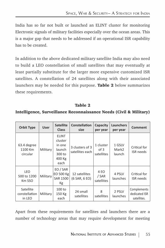
55NatioNal iNstitute of advaNced studies
Space, War & Security– a Strategy for india
India has so far not built or launched an ELINT cluster for monitoring
Electronic signals of military facilities especially over the ocean areas. This
is a major gap that needs to be addressed if an operational ISR capability
has to be created.
In addition to the above dedicated military satellite India may also need
to build a LEO constellation of small satellites that may eventually at
least partially substitute for the larger more expensive customized ISR
satellites. A constellation of 24 satellites along with their associated
launchers may be needed for this purpose. Table 2 below summarizes
these requirements.
Table 2
Intelligence, Surveillance Reconnaissance Needs (Civil & Military)
Orbit Type UserSatellite
ClassConstellation
sizeCapacity per year
Launchers per year
Comment
63.4 degree 1100 Km circular
Military
ELINT cluster in one launch 300 to 400 Kg each
3 clusters of 3 satellites each
1 cluster of 3
satellites
1 GSLV Mark2 launch
Critical for ISR needs
LEO500 to 1200
Km SSOMilitary
EO / SAR EO 500 Kg SAR 1500
Kg
12 satellites(6 SAR, 6 EO)
4 EO / SAR
satellites
4 PSLV launches
Critical for ISR needs
Satellite constellation
in LEOMilitary
100 to 150 Kg each
24 small satellites
8 satellites
2 PSLV launches
Complements dedicated ISR
satellites.
Apart from these requirements for satellites and launchers there are a
number of technology areas that may require development for meeting
56 NatioNal iNstitute of advaNced studies
Space, War & Security– a Strategy for india
operational needs. Some of these critical areas are:
• ELINT Technology Development
• Infrared Technologies and Imaging Sensors
• Improved Integrated Optics for Imaging sensors
• SAR weight reduction initiatives
• Small satellites related developments
• Data Processing especially SAR data processing
• Use of commercial open source data for strategic work
• Tracking Data Relay Satellite System (TDRSS) Compatibility related
developments
57NatioNal iNstitute of advaNced studies
5.0 capacitieS, capaBilitieS & gapS - Space BaSed Support ServiceS for c4iSr
5.1 Telemetry Tracking & Data Relay Satellites (TDRSS)
In addition to the command, control and communications functions that can
be carried out via satellite Networks, satellites are also used to command,
control, communicate with and receive relay data from a large number of
orbiting satellites that collect ISR related information from around the world.
Such command, control and data collection functions were originally carried
out through a network of ground stations located suitably around the world.
In spite of the use of a large number of stations, collection and relay of data
from this network of ground station did not provide adequate global coverage.
Two or three Tracking and Data Relay Satellites in Geostationary Orbit
located suitably over a country provide a way in which the coverage of ISR
assets can be extended over a large part of the earth.
The US pioneered the use of such satellites with the first of them entering
operational service in 1983.
The US currently has nine such satellites in orbit that cover the Atlantic,
Pacific and Indian Oceans. The constellation comprises first generation,
second generation as well as third generation satellites. The third
generation satellites have a launch mass of about 3200 Kg.50
50 UCS_Satellite_Database_9-1-15 at http://www.ucsusa.org/nuclear-weapons/space-weapons/satellite-database.html#.Vgou932rHgI
58 NatioNal iNstitute of advaNced studies
Space, War & Security– a Strategy for india
The primary ground stations are located at White Sands New Mexico. The
US also has a station in Guam for complete coverage.
In principle two satellites can cover all satellites in orbit from 200 Km
onwards. However if both satellites have to connect to a single ground
station there could be some gaps in coverage. For Low Earth Orbits between
200 and 1200 Km coverage of all satellites will be better than 85%.51
Russia too followed the US example and the first Luch satellite was
launched in 1985. Three Luch satellites located at 16 W , 95 E and 160
W in GSO provided coverage over the Atlantic, Indian and Pacific Oceans
respectively. After the break-up of the Soviet Union this capability took a
back seat and only one second generation Luch satellite was launched in
1995. It stopped working in 1998. These satellites had a mass of about
2400 Kg and were directly injected into a near geostationary orbit. 52
More recently the programme has been revived. Three satellites Luch 5A,
5B 5V are available for use by the Russian manned and military space
programmes. These satellites are located at 16 W, 95 E and 167 W in GSO
to provide global coverage. They have lift off masses of between 1000 to
1300 Kg and are directly injected into GSO by the Proton Launcher.53
Japan also has in place one experimental data relay satellite called the
Kodama Data Relay Test Satellite (DRTS). This is being used to support Space
51 W.M.Holmes Jr., “NASA’s Tracking and Data Relay Satellite System “, IEEE Communications Society Magazine, September 1978, PP 13-20 available at http://ieeexplore.ieee.org/stamp/stamp.jsp?arnumber=1089760
52 http://www.russianspaceweb.com/luch.html provides an early history of the USSR / Russian Federation initiatives on TDRSS.
53 UCS_Satellite_Database_9-1-15 at http://www.ucsusa.org/nuclear-weapons/space-weapons/satellite-database.html#.Vgou932rHgI
59NatioNal iNstitute of advaNced studies
Space, War & Security– a Strategy for india
Station activities as well as data relay from Japanese remote sensing satellites.
Located at 90E over the Indian Ocean it provides coverage of at least 60 % of
the orbit of a LEO satellite. The satellite has a Beginning of Life mass in GSO
of about 1500 Kg. This will translate into a payload of about 3500 Kg in GTO
which is very similar to the third generation of US TDRSS satellites.54
After experimenting with satellite to satellite optical links via an experimental
satellite called Artemis, Europe is poised to employ its own data relay system
called the European Data Relay System (ERDS). It will be first system to use
optical satellite to satellite links. One Data relay node will be deployed on the
Eutelsat 9B satellite located at 9 E. The other will be deployed on another
combination satellite located at 31 E. The first satellite will link data from the
orbiting Sentinel series of satellites to ground stations in Europe. The satellite
to satellite connections will be optical allowing higher data rates. Ka band
links will also be there. The first satellite is due to be launched in 2015.55
China also has three TDRSS satellites in GSO located at 77.08 E, 176.72
E and16.86 E. These are meant to exercise command control and data
relay functions for their manned space programme and their military ISR
satellites such as those of the Yaogan series.
The first Chinese TDRSS satellite Tian Lian 1 was launched by Long March
3C launcher in 2008. It had a GTO mass of 3800 Kg. The second in the series
Tian Lian 2 was launched in 2011. It had a GTO mass of 2250 Kg. The third
54 Details available at http://global.jaxa.jp/activity/pr/brochure/files/sat10.pdf 55 Dr. Harald Hauschildt et al, “European Data Relay System – one year to go!”
Proc. International Conference on Space Optical Systems and Applications (ICSOS) 2014, S1-3, Kobe, Japan, May 7-9 (2014) at http://icsos2012.nict.go.jp/pdf/1569603307.pdf
60 NatioNal iNstitute of advaNced studies
Space, War & Security– a Strategy for india
in the series was launched in 2012 and had a mass of 2000 Kg in GTO. 56
If India choses to enhance its ISR capabilities via space based assets it
will definitely require secure channels over which data from this large
constellation can be reached to a central control and command center.
Between three to five operational TDRSS satellites may therefore be
needed for performing these functions.
These are advanced satellites operating in several frequencies that can
exercise C4 functions over an orbiting constellation of ISR satellites in
a secure fashion. They are very similar to the advanced multipurpose
multi frequency multi beam communications satellites. As the European
example shows conventional and data relay packages can be combined
in one satellite. They will have to deploy and use a number of antennae
and antennae beams to provide the needed service. At some stage in the
near future the satellite to satellite links may require the use of laser
communications systems.
These satellites may need masses of over 3500 Kg in GTO. With
the use of ion propulsion these masses could come down.
India may need three such satellites in orbit with at least
two of them operational at any given time. A capacity of
one intermediate class satellite weighing about 3000 to
4000 Kg along with one launcher of the GSLV Mark 3 may
be needed for this purpose. With ion propulsion this could
come down to a 2000 to 2500 Kg spacecraft launched by
the GSLV Mark 2.
56 UCS_Satellite_Database_9-1-15 at http://www.ucsusa.org/nuclear-weapons/space-weapons/satellite-database.html#.Vgou932rHgI
61NatioNal iNstitute of advaNced studies
Space, War & Security– a Strategy for india
India has so far not built such an advanced spacecraft. This
is a gap that needs to be addressed for meeting both civilian
and military needs.
5.2 Weather Satellites
Monitoring the weather is also an important component for the effective
operation of any ISR system. Advanced space powers use a combination
of geostationary and polar orbiting satellites to provide weather forecasts.
The sensors that are carried on both these platforms and the platforms
themselves have seen several generations of evolution. Imaging sensors,
sounders that measure vertical profiles operating in the visible, infra-red
and microwave regions of the spectrum along with specialized instruments
for measuring substances like ozone and other pollutants provide a wealth
of data. These are used for making short medium and long range forecasts
and for monitoring the earth environment. All these satellites also come
equipped with the capability to receive data from data collection platforms
on the ground and reach them to a forecasting center.57
In the US though weather services for the military was kept separate from the
civilian requirement for quite some time for operational and efficiency reasons
the two capabilities have been merged. NASA, NOAA and the military now
work together for providing weather data for both civilian and military users.58
The US operational capability at any given point in time comprises a
minimum of three GOES weather satellite in GSO. Two of them provide real
57 Gary Davis, “History of the NOAA Satellite Program”, http://www.osd.noaa.gov/download/JRS012504-GD.pdf
58 R. Cargill Hall, “A History of the Military Polar Orbiting Meteorological Satellite Programme “, Office of the Historian, National Reconnaissance Office, Center for the Study of National Reconnaissance, September 2001, available at http://www.nro.gov/history/csnr/programs/docs/prog-hist-02.pdf
62 NatioNal iNstitute of advaNced studies
Space, War & Security– a Strategy for india
time data with the third serving as an in-orbit spare. They carry imaging as
well as sounding payloads operating in the visible, infrared and microwave
wavelengths. They also carry a number of other instruments that provide
data related to other weather and climate needs as well as space weather.
The GOES 15 satellite weighs 3238 Kg at lift off.
The US also has a minimum of two polar orbiting satellites (there are
currently 5 working satellites) in sun synchronous orbit. These provide
data from a standard set of instruments and allow measurements that
provide a better handle on forecasts over a few days. These are in an 870
Km sun synchronous orbit. Their mass is 1420 Kg.59
Europe too has a similar combination of geostationary and orbiting satellites
for providing weather satellites. The Second Generation Meteosat (SGM)
satellites have now replaced most of the first generation GSO Meteosat
satellites. Europe now has five satellites of which one is an in-orbit spare that
cover Europe, Africa and the Indian Ocean Area. SGM satellites have a lift off
mass of around 2000 Kg and a beginning of Life Mass in GSO of 1200 Kg.
Europe also has two orbiting satellites in polar SSO the Metop A and the
Mettop B. These are in 817 Km Sun Synchronous Orbit. Two of them are
currently in orbit whilst the third is available for launch. The lift of mass of
these satellites is 4085 Kg.60
There is a large degree of overlap and continuity between the various
instruments carried by the US and Europe. However Europe has added a
number of additional instruments in order to understand in greater scientific
59 http://noaasis.noaa.gov/NOAASIS/ml/genlsatl.html 60 http://www.eumetsat.int/website/home/Satellites/CurrentSatellites/
Meteosat/index.html
63NatioNal iNstitute of advaNced studies
Space, War & Security– a Strategy for india
detail climate change as well as other major issues that could affect the earth.
Russia went through major problems with its space programme after the
demise of the Soviet Union. The weather satellite programme was also
affected in a serious way.
The original Meteor 1 orbiting weather satellite series was replaced by the
Meteor 2 series and then by the Meteor 3 Priroda and the Meteor 3 series.
The Meteor 1 and 2 series were in an 81.2 degree inclined orbit but satellites
in the later series were in sun synchronous orbits at different altitudes.
The Meteor 3 M as well as the Meteor M series developed by Russia after
the breakup have also had their share of problems. The first satellite of
the Meteor M weather satellite series was launched by a Soyuz / Fregat
launcher in September 2009. Problems have been reported with the
infrared channel of the imager as well as with image correction. The
satellite is reported to have failed completely by 2014.
This satellite is in an 832 Km 98.7 degree sun synchronous orbit. The
satellite is reported to have a mass of between 2700 to 2900 Kg.61
The Soviet Union and later Russia did not have a weather satellite in GSO
for quite some time though the Soviet had announced plans for them prior
to the breakup. Russia did launch a GSO weather satellite in 1994 but this
failed in 1998 leaving it without a GSO based weather prediction capability.
After a number of problems the Elektro L satellite was launched by a Zenit /
Fragat combination from Baikonur in 2011. The satellite is working well and
61 http://www.russianspaceweb.com/meteor.html
64 NatioNal iNstitute of advaNced studies
Space, War & Security– a Strategy for india
is located at 76 degree East in the GSO. The satellite mass in GSO is reported
to be 1766 Kg which will mean a satellite mass of nearly 4000 Kg in GTO.62
Problems with their weather satellites have forced Russia to depend on the
US and European data for their weather forecasts.
China launched its first Geostationary Satellite for weather forecasting in
1997. It has since followed this up with a series of Fengyun 2 satellites that
provide continuous coverage.
There are currently four Fengyun 2 satellites in orbit with three of them
operational and one replacement satellite These satellites have a lift off mass
of 1390 Kg and are put into a GTO orbit by the Long March 3A launcher.
China has also in place a series of orbiting Fengyun 3 satellites that are
in Sun synchronous orbit of 825 Km. They provide complementary global
coverage to the GSO satellites. These satellites have a liftoff mass of 2300
Kg and are put into orbit by the Long March 4 C launcher.63
Though India does not have any operating weather satellites in polar orbit it does
have a number of satellites that provide dedicated weather services from GSO.
The INSAT 3D satellite has a complement of sensors that provides data on
par with other such satellites operating across the globe.64
Figure 14 provides an overview of India’s capabilities vis a vis
some of the other players in providing weather services from
62 http://www.russianspaceweb.com/elektro.html 63 UCS_Satellite_Database_9-1-15 at http://www.ucsusa.org/nuclear-weapons/
space-weapons/satellite-database.html#.Vgou932rHgI 64 http://www.isro.gov.in/Spacecraft/insat-3d
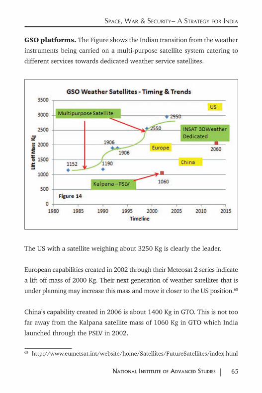
65NatioNal iNstitute of advaNced studies
Space, War & Security– a Strategy for india
GSO platforms. The Figure shows the Indian transition from the weather
instruments being carried on a multi-purpose satellite system catering to
different services towards dedicated weather service satellites.
The US with a satellite weighing about 3250 Kg is clearly the leader.
European capabilities created in 2002 through their Meteosat 2 series indicate
a lift off mass of 2000 Kg. Their next generation of weather satellites that is
under planning may increase this mass and move it closer to the US position.65
China’s capability created in 2006 is about 1400 Kg in GTO. This is not too
far away from the Kalpana satellite mass of 1060 Kg in GTO which India
launched through the PSLV in 2002.
65 http://www.eumetsat.int/website/home/Satellites/FutureSatellites/index.html
66 NatioNal iNstitute of advaNced studies
Space, War & Security– a Strategy for india
India’s INSAT 3D with a mass of 2060 Kg launched in 2013 is on par with
European second generation weather satellites.
India thus appears to be on par with Europe and ahead of
China with regard to weather services on GSO platforms.
As far as near polar orbiting satellites are concerned the minimum need appears
to be at least two operational satellites with one spare in orbit. The US orbiting
satellites with a mass of 1420 Kg appears to be the leader. European orbiting
satellites are much heavier with a mass of 4085 Kg. However the instruments
they carry cater to a variety of needs with many new sensors being tried out
for a range of applications. These complications make comparison with other
operational systems difficult. Russian orbiting satellites have masses of 2700
to 2900 Kg. They have had a number of operational problems in recent times.
Chinese orbiting satellites have masses of about 2300 Kg.
As mentioned earlier India has no orbiting weather satellites. It may have to
add these to its capabilities if it needs to use space assets for a C4ISR function.
The IRS platform may be suitable for this purpose. However the addition
of an infrared channel to the imaging instrument may create complications
because of the cooling requirement for the detectors. The PSLV launcher
could maybe place about 1400 to 1500 Kg in an 800 Km sun synchronous
orbit. This may be adequate for meeting the needs. In case of problems these
could always be launched by the more powerful GSLV Mark 2.
Based on the current record one GSO satellite may need to be
built every three years to maintain the current constellation.
These could be launched on the GSLV Mark 2 until the GSLV
Mark 3 becomes available.
67NatioNal iNstitute of advaNced studies
Space, War & Security– a Strategy for india
In addition a constellation of three orbiting satellites operating
in an 800 km sun synchronous orbit may be needed to
complement the GSO weather forecasting capabilities. It may
be possible to build them within a mass of 1500 Kg compatible
with a PSLV launch. In case heavier satellites are needed one may need
to launch it on a GSLV Mark 2 vehicle.
Taken together both these needs will need a satellite manufacturing
capability of one satellite per year along with a launch capability
of one GSLV Mark 2 or one PSLV vehicle per year.
Sensor capabilities including the incorporation of infrared
channels with the visible and near infrared channels typical of
most current instruments may also need to be strengthened.
The building and testing of other new instruments for monitoring the
weather and the climate and testing on orbiting platforms before moving
them to the GSO may also need support.
Globally most western countries are moving to integrate the civilian and
military components of the weather function into a single constellation
of satellites catering to both users. This is consistent with current Indian
practice and with certain administrative arrangements in place may be
adequate to take care of both civilian and military needs.
5.3 Space Based Navigation Systems
The parameters for assessing performance of satellite based navigation
systems would be linked to position accuracy, velocity accuracy and timing
accuracy. In our assessment the position accuracy along with the mass of
68 NatioNal iNstitute of advaNced studies
Space, War & Security– a Strategy for india
the satellite has been used as the basis for evaluating capability.66
In view of the importance of navigation for meeting security needs many
space powers are keen to establish their own system. Currently the US GPS
and the Russian Glonass system offer global coverage.67
The use of satellites for navigation purposes has been around for quite
some time. The US GPS system set a new standard for accurate position
fixing using a constellation of 24 satellites in Medium Earth Orbit. It has
now become a global standard. Here too the distinctions between civilian
and military use are becoming increasingly blurred.
Both the GPS and Glonass systems work on the principle that at least
four satellites whose positions in space are known accurately are always
available to a receiver on the ground. Using the signals along with the
known positions of the satellite the position of the receiver can be estimated.
The GPS satellites are in a near circular orbit at an altitude of about 20000
Km with an inclination of 55 degrees. Three generations of satellites
comprise the current constellation. The masses of the satellites at liftoff
range from 1630 to 2200 Kg. The current generation has a lift off mass of
1630 Kg. The lifetime of these satellites are 10 years.68
The Russian Glonass system consists of 28 satellites in the current
constellation. They are in 19100 Km orbit with an inclination of 64.8
66 For an overview see Gerhard Beutler, “Satellite Navigation System for Earth and Space Sciences”, International Space Sciences Institute, Spatium No. 10, June 2003, pp 3-19 at http://www.issibern.ch/PDF-Files/Spatium_10.pdf
67 https://www.princeton.edu/~alaink/Orf467F07/GNSS.pdf 68 UCS_Satellite_Database_9-1-15 at http://www.ucsusa.org/nuclear-weapons/
space-weapons/satellite-database.html#.Vgou932rHgI
69NatioNal iNstitute of advaNced studies
Space, War & Security– a Strategy for india
degrees.69 Starting in 1982 the first complete constellation of 24 satellites
was established in 1995 about a year behind the US GPS system. After a
period of time during which the operational capability got diluted the entire
programme got a fillip in 2001. Complete coverage was restored in 2011.
The Glonass programme has also seen three generations of navigation
satellites. The first generation satellites had lift off masses of about 1260 Kg
and were launched three at a time on the Proton launcher. Direct injection
into the required orbit is a feature of the Proton Soyuz launches. Thus the
propellant mass on the satellite could be less leading to a lower satellite
mass in comparison to the launches from Western countries. The second
generation satellites had a lift off mass of 1415 Kg. The mass of the third
generation satellites is 930 Kg.70
The capabilities of the system originally meant for military use has been
opened up for civilian use. Most navigation receivers are compatible with
both GPS as well as Glonass. The higher inclination orbit provides better
coverage at higher latitudes.
Europe is planning to set up its own Galileo Network of orbiting satellites
to provide navigation services to both Europe and the rest of the world.
It is in the process of establishing a constellation of 30 satellites with 24
operational and six backup in-orbit spares. The satellites are distributed
equally in three orbital planes. They orbit the earth at an altitude of 23222
Km with an inclination of 56 degrees. Ten of these satellites have already
been launched with the constellation due for partial service in 2018 and
complete services in 2020. The satellites have a lift off mass of 733 Kg.
They are launched two at a time by the Soyuz Rocket from Korou in French
69 For the current status of the constellation see https://glonass-iac.ru/en/GLONASS/ 70 For details see http://www.russianspaceweb.com/uragan.html
70 NatioNal iNstitute of advaNced studies
Space, War & Security– a Strategy for india
Guiana. With modifications being carried out to the Ariane 5 launcher they
could be launched four at a time on future flights of the Ariane 5 launcher.71
Japan is a country where high mountains and high buildings make access to
good quality reception from GPS satellites difficult. This resulted in a different
architecture for their satellite constellation. Rather than competing directly
with the GPS they chose an approach that would complement and enhance
GPS capabilities within their region. The system should also serve as a backup
in case there were problems with the availability of the GPS system.
The Japanese system involves a constellation of seven satellites. Four of them
are in inclined geosynchronous orbits. The orbit inclination is chosen in such
a way that at least one satellite will always be visible to users in Japan. These
along with three satellites in GSO will provide the four signals for locating
the position on the ground. These satellites will transmit position and time
and error correction in the same bands and frequencies as the GPS system.72
So far Japan has put into orbit one satellite of their Quasi Zenith Satellite
System (QZSS). This satellite was launched in 2010 by the Japanese H2A
launcher. The mass of the satellite is 4000 Kg and it is in a geosynchronous
orbit with an inclination of 40 degrees.73 Reports suggest that with this
satellite in place and with data that comes from precisely located receivers
on the ground whose separation distances are accurately known error
corrections received by users via the geosynchronous satellite has improved
71 http://www.esa.int/Our_Activities/Navigation/The_future_-_Galileo/What_is_Galileo
72 Hideto Takahashi, “Regional Navigation Satellite System ‘The JRANS Concept’, Journal of Global Positioning Systems Vol 3, No 1-2, 259-264, 2004 at http://www.sage.unsw.edu.au/wang/jgps/v3n12/v3n12p32.pdf
73 UCS_Satellite_Database_9-1-15 at http://www.ucsusa.org/nuclear-weapons/space-weapons/satellite-database.html#.Vgou932rHgI
71NatioNal iNstitute of advaNced studies
Space, War & Security– a Strategy for india
location accuracies from the meter to the centimeter level. Japan proposes
to augment its capacity with the launch of 3 more inclined geosynchronous
satellites as well the three satellites in GSO in the next few years to complete
the system.74
China proposed a regional navigation system pushed largely by the military
that initially involved only the use of Geostationary satellites for determining
position on the ground. This approach largely depended on responding
to signals sent out by the control station to the users via two satellites in
Geostationary Orbit. The user responds to both signals which are received
by the control station. The received data is processed to estimate the two
dimensional position. This is then compared to a three dimensional data base
and the combined data is sent back to the user as the determined position.
The original system was based on two satellites with two satellites serving as
a backup. The position accuracy was demonstrated to be about 100 m. The
last of the satellites to be launched as a part of this experimental phase was
in 2007. It is possible that with a network of ground control stations, laser
tracking of the satellites in GSO as well as conventional GPS capabilities
the accuracy of the position location for the users could be improved via
transmission of corrections through the Geostationary satellites.
After this experimental phase China has gone ahead and is in the process of
establishing a complete operational system. The proposed system will first
provide a service compatible with other services such as GPS, Glonass as
well as Galileo. When it is completed by about 2020 it will offer a complete
global service for all users.
The proposed system will comprise 35 satellites. Five of them will be
in Geostationary Orbit (GSO), three will be in an inclined 55 degree
74 http://www.theregister.co.uk/2014/04/24/japan_satellite_qzss_enhanced_gps/
72 NatioNal iNstitute of advaNced studies
Space, War & Security– a Strategy for india
geosynchronous orbit and there will be 27 satellites in a Medium Earth Orbit
(MEO) of 21540 Km. 24 of the MEO satellites will be functional with three
satellites acting as in orbit spares. The 27 satellites will be in three different
orbital planes inclined at 55 degrees. In a sense this new architecture
combines the Japanese and US systems to provide a complete service. There
will be an open service as well as a secure service for some users.75
So far China has launched 20 satellites as a part of its second generation
system.76 The preliminary evaluation of system performance is consistent
with other comparable systems in the world.77
The GSO satellites have a mass of 4600 Kg at liftoff and are launched by
the CZ 3C launcher.
The satellites in inclined geosynchronous orbits have a mass of 4200 Kg
and are launched by the CZ 3B launcher.
The MEO can either be launched into a transfer orbit from where they are
taken to the final orbit or the third stage can directly inject them in to the
required 21500 Km inclined orbit. For the former case the satellite mass
is 2200 Kg launched by a CZ 3A launcher. For the latter case the mass is
800 Kg and the satellites are launched two at time by CZ 3B launcher. The
latest launch of September 2015 is a dual launch of the 800 kg satellite
into a direct 21500 km orbit by a modified improved CZ 3B vehicle with an
75 https://directory.eoportal.org/web/eoportal/satellite-missions/c-missions/cnss 76 China Launches 20th Satellite for BeiDou Navigation System, Press Trust of India
, 30 September 2015, http://gadgets.ndtv.com/internet/news/china-launches-20th-satellite-for-beidou-navigation-system-746510
77 Oliver Montenbruck et al, Initial assessment of the COMPASS/BeiDou-2 regional navigation, http://saegnss1.curtin.edu.au/Publications/2013/Montenbruck2013Initial.pdf
73NatioNal iNstitute of advaNced studies
Space, War & Security– a Strategy for india
augmented upper stage.78
India’s efforts at improved navigation are oriented around two kinds of
approaches. In the first approach the existing civilian capabilities using
GPS are improved in order to improve the accuracy of position fixing and
navigation. The Indian system called Gagan uses a precisely positioned
network of ground stations to eliminate some of the systemic errors in
the reception of GPS signals. These error corrections are transmitted
continuously to all users within the region via a geostationary satellite who
then correct the GPS based positions. This system is being deployed in
India to facilitate precision landing of aircraft.79
India is also in the process of setting up an Indian Regional Navigation
Satellite Service (IRNSS). When completed, the system will have four
satellites in a 30 degree inclination geosynchronous orbit and three other
satellites in Geostationary Orbit. Together they will provide an India
oriented navigation service that caters to both civilian and military uses. The
system being set up may also be compatible with additional enhancements
based upon improvements from a precision based ground network set up
for the Gagan service.80
The Indian system is very similar to the original Japanese systems and also
close to the initial capability proposed by the Chinese Beidou 2 system of a
combination of Geostationary and inclined geosynchronous satellites.
Four satellites have been launched as a part of the regional constellation.
78 For details please see https://directory.eoportal.org/web/eoportal/satellite-missions/c-missions/cnss
79 S.V.Kibe, “Indian plan or satellite based navigation for Civil Aviation”, Current Science, Vol. 84 No 11, 10 June 2003, pp 1405-1411.
80 http://www.isro.gov.in/sites/default/files/pdf/pslv-brochures/PSLVC22.pdf
74 NatioNal iNstitute of advaNced studies
Space, War & Security– a Strategy for india
These satellites have a liftoff mass of 1425 Kg and have been launched by
the PSLV. Three more satellite launches to be carried out in the near future
would complete the regional system.81
While it is difficult to evaluate in detail the accuracy resulting from a
combination of GSO and inclined Geosynchronous orbit satellite system
it is likely to be worse than the accuracy obtained from an orbiting
constellation of satellites. If the regional system can also use GPS and
the Gagan capabilities the resulting accuracies may be adequate for most
military needs. However such an approach may make India dependent on
a foreign source for meeting a military need. If the India US relationship
can guarantee such a continuity of the GPS service this approach will be
a good and cost efficient solution for meeting both civilian and military
needs. The US has so far not put any restrictions on the civilian use of the
GPS signals but whether this approach will continue under all conditions
is a difficult assessment to make. One way to reduce this risk is to make
the Indian system compatible with GPS, Glonass as well as the proposed
European Galileo system. However at some point it may be prudent to set
up our own system to meet at least the country’s military needs.
Based on the assumption that an indigenous constellation may also be
needed India may need to move towards a constellation in a phased way
over the next ten years. Based on the experience of other countries this
may require a constellation of about 30 satellites in GSO, geosynchronous
and MEO orbits.
In addition to the GSO needs this would translate into a
satellite capacity of 3 satellites in a MEO every year. The dry
mass of the navigation satellites launched by PSLV is 600 Kg. Based on
81 http://www.isro.gov.in/sites/default/files/pdf/pslv-brochures/PSLVC22.pdf
75NatioNal iNstitute of advaNced studies
Space, War & Security– a Strategy for india
current Indian practice it may be possible to place a meaningful navigation
payload into a MEO orbit through the PSLV. Thus three PSLV launches
may also be required for the constellation.
Accurate timing is needed for the operation of satellite based navigation
systems. These are provided by atomic clocks carried on all the satellites.
Indigenous capabilities to make these clocks and qualify them for use in
space may be important. It may be possible to design navigation systems
that do not need atomic clocks. Exploring such possibilities may also be an
area of interest to a country like India.
Given the importance of the navigation function in the conduct of
modern war complete dependence on another country may not be
desirable. China and Europe are currently setting up a full-fledged
independent system that caters to their own civilian and military needs.
Their systems could also service civilian users around the world. Such
systems will necessarily involve a larger constellation of both orbiting
and geosynchronous and geostationary satellites. If India decides to go
that way to enhance its capabilities significant capacity additions to
satellite and launch capacities will be needed. The projections made
are on the basis that over the next ten years India would establish a
full-fledged Satellite based navigation system of its own to cater to both
the civilian and military needs. During this transition period existing
systems could be used along with the proposed IRNSS to improve
accuracies.
5.4 Space Based Support Services Overall Needs
Table 3 summarizes the satellite and launch vehicle needs for various
satellite based support services needed by the military. These services
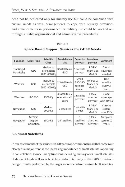
76 NatioNal iNstitute of advaNced studies
Space, War & Security– a Strategy for india
need not be dedicated only for military use but could be combined with
civilian needs as well. Arrangements to cope with security provisions
and enhancements in performance for military use could be worked out
through suitable organizational and administrative procedures.
Table 3
Space Based Support Services for C4ISR Needs
Function Orbit Type Satellite
ClassConstellation
sizeCapacity per year
Launchers per year
Comment
Tracking & Data Relay GSO
Medium to Intermediate
2000 -4000 Kg
3 Satellites in GSO
1 satellite per year
1 GSLV Mark 2 or
Mark 3
Global coverage needed
Weather GSOMedium to
Intermediate 2000 -3000 Kg
2 Satellites in GSO
Small GSO SSO satellite similar
One GSLV Mark 2 or
Mark 3
One satellite every 3 years
Weather LEO SSO 1500 Kg3 satellites -2 operational 1
spare
1 satellite per year
1 PSLV launcher per year
Global coverage
with TDRSS
Navigation GSO Medium 2000 Kg 7 satellites 1 satellite
a year
1 GSLV Mark 2 or
Mark 3
Current system
uses PSLV
Navigation MEO 50 degree
inclination 1500 Kg 24 satellites
3 satellites per year
3 PSLV launches per year
Complete system 10
years
5.5 Small Satellites
In our assessments of the various C4ISR needs one common thread that comes out
clearly as a major trend is the increasing importance of small satellites operating
in constellations to meet many functions including military ones. Small satellites
of different kinds will soon be able to substitute many of the C4ISR functions
being currently performed by the larger more specialized custom built satellites.
77NatioNal iNstitute of advaNced studies
Space, War & Security– a Strategy for india
This is an area where India needs to enhance its capabilities and capacities in a
significant way for meeting both commercial and military needs.82
Developments in micro and nano electronics make possible increased
processing and storage capabilities with lower levels of power consumption.
Integration of the sensing function with the conversion of analog to digital
signals along with other processing capabilities make possible greater
functional capabilities within smaller masses and lower power requirements.
Megapixel CCD based cameras are now available as off the shelf items.
Developments in Micro-Electromechanical Systems (MEMS) make possible
the building of gyros and accelerometers needed for control purposes.
The availability of GPS receivers, modeling software of various kinds, the
Internet as well as many low cost options for launch all contribute towards
reducing various barriers in building and launching small satellites.83
Though India has not launched a large number of small satellites the PSLV
launcher has become a work horse for providing launch services for these
satellites. Many of these satellites have been taken as secondary payloads
in various PSLV missions. The launch vehicle team has developed a number
of different adaptors for mounting these satellites along with other bigger
82 For an understanding of how small satellites can be used for meeting military needs see Rajaram Nagappa, “The Promise of Small Satellites”, NIAS Report no. R33-2015, December 2015.
83 Siegfried W Janson, “25 Years of Small Satellites”, 25th Annual AIAA / USU Conference on Small Satellites, 2011, http://digitalcommons.usu.edu/cgi/viewcontent.cgi?article=1117&context=smallsat
78 NatioNal iNstitute of advaNced studies
Space, War & Security– a Strategy for india
payloads.84 Dedicated adaptors and dispensing mechanisms have also been
developed for placing multiple small satellites in orbit. Over 40 satellites
for 19 countries have been successfully launched by the PSLV. Most of these
are in the small satellite category. From a preliminary survey many of them
are the early progenitors of future C4ISR systems. 85
The PSLV record both in terms of launch reliability as well as in meeting
the global needs for small satellite launch capability has been outstanding.
Capacities for building and launching such satellites outside of the space
programme are practically non-existent. A major national effort to promote
the building and launching of these satellites for meeting a variety of needs
has to be undertaken. Unlike most of the other advanced space powers
including China that have an ecosystem that supports entrepreneurs
and startups, India provides no support that encourage entrepreneurial
activities in the country. Though private companies provide support to the
space effort there are no independent players that can build a satellite or a
launcher or even manage a mission. In spite of the proven potential of PSLV
for launching small satellites the Indian record for space startups does not
compare well with those of other major space powers.
A major effort to change this state of affairs will be needed. This will
necessarily have to come out of initial funding support both for satellite
building as well as for launching them. These requirements will be over
and above those identified as part of the constellations that have to be
launched for meeting the more immediate C4 and ISR needs.
An annual outlay of about Rs. 100 crore may be needed for
84 http://www.isro.gov.in/sites/default/files/pdf/pslv-brochures/PSLVC7.pdf 85 http://www.isro.gov.in/sites/default/files/pdf/pslv-brochures/PSLV-C28.pdf
79NatioNal iNstitute of advaNced studies
Space, War & Security– a Strategy for india
promoting the small satellite initiative in the country. In
addition to providing launch services on an available basis the
Plan for small satellites should involve the launch of small
satellite constellations for a variety of functions maybe through
dedicated launches. The promotion of startups through this
initiative should also be a high priority.
There are also other possibilities for meeting launch needs for
small satellites. These call for looking at existing missile and
various available rocket motors and build a satellite launch
vehicle around them. These are addressed separately in the
Launcher section.
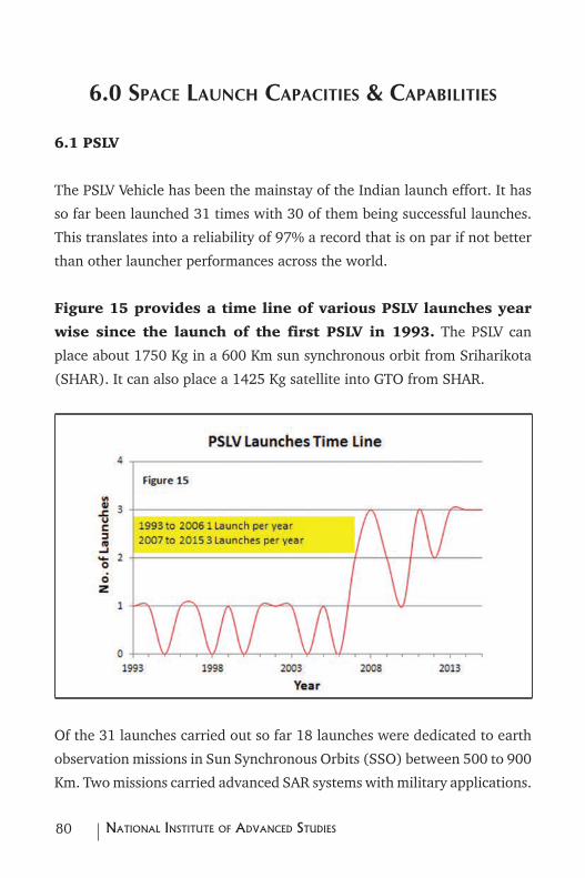
80 NatioNal iNstitute of advaNced studies
6.0 Space launch capacitieS & capaBilitieS
6.1 PSLV
The PSLV Vehicle has been the mainstay of the Indian launch effort. It has
so far been launched 31 times with 30 of them being successful launches.
This translates into a reliability of 97% a record that is on par if not better
than other launcher performances across the world.
Figure 15 provides a time line of various PSLV launches year
wise since the launch of the first PSLV in 1993. The PSLV can
place about 1750 Kg in a 600 Km sun synchronous orbit from Sriharikota
(SHAR). It can also place a 1425 Kg satellite into GTO from SHAR.
Of the 31 launches carried out so far 18 launches were dedicated to earth
observation missions in Sun Synchronous Orbits (SSO) between 500 to 900
Km. Two missions carried advanced SAR systems with military applications.
81NatioNal iNstitute of advaNced studies
Space, War & Security– a Strategy for india
6 launches including four launches for the IRNSS and one launch for the
Kalpana weather satellite were into GTO orbits. Two launches were for
exploration of the solar system with one mission to the moon and the
other to Mars. Three launches were dedicated to international scientific
missions.86
The PSLV record has been outstanding. Over time a number of improvements
have been made. Three configurations are available with different payload
capabilities providing some degree of flexibility. PSLV also has been very
successful in launching many small satellites as co-passengers along with
the main mission.
From an ISR point of view the recent launch of PSLV C28 with three
state of art remote sensing satellites built by the Surrey Satellite
Technology Limited (SSTL) where three satellites spaced 120 degrees
apart were put into a 647 Km Sun Synchronous Orbit is an indication
of its capabilities.87
From the above assessment it is clear that all ISR requirements
as well as many smaller satellites required for the C4 and other
support functions can be met through PSLV if the country is
able to augment the capacity for building and launching them
in adequate numbers.
From Figure 15 it is clear that current capacity for PSLV
launches is three a year. Keeping in mind the various
requirements projected earlier this capacity may require
significant augmentation.
86 http://www.isro.gov.in/launchers/pslv 87 http://www.isro.gov.in/sites/default/files/pdf/pslv-brochures/PSLV-C28.pdf
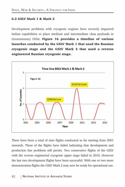
82 NatioNal iNstitute of advaNced studies
Space, War & Security– a Strategy for india
6.2 GSLV Mark 1 & Mark 2
Development problems with cryogenic engines have severely impacted
Indian capabilities to place medium and intermediate class payloads in
Geostationary Orbit. Figure 16 provides a timeline of various
launches conducted by the GSLV Mark 1 that used the Russian
cryogenic stage and the GSLV Mark 2 that used a reverse
engineered Russian cryogenic stage.
There have been a total of nine flights conducted so far starting from 2001
onwards. Three of the flights have failed indicating that development and
production line problems still persist. Two consecutive flights of the GSLV
with the reverse engineered cryogenic upper stage failed in 2010. However
the last two development flights have been successful. With one or two more
demonstration flights the GSLV Mark 2 may now be ready for operational use.
83NatioNal iNstitute of advaNced studies
Space, War & Security– a Strategy for india
The current capacity may be around 1 GSLV Mark 2 launcher per year.
The GSLV Mark 2 when operational could place a 2500 Kg payload into
GTO or 5000 Kg into LEO from SHAR.88
Communications satellites with this mass are categorized in the medium
size category.
As we had mentioned in the earlier part of this report the global trend is to
move away from the medium and intermediate size categories towards the
heavy and very heavy categories.
In keeping with this trend India may also have to be able to place heavier
payloads in GTO especially for military applications.
With the use of ion propulsion however some short term
gains at least can be achieved. Because of reduced propellant
weights on the satellite more mass can be made available for
satellite functions as against propulsion functions. With this
capability even the GSLV Mark 2 could place the equivalent of
a 4000 Kg intermediate class payload in GTO.
This is one way in which the gap in both satellite and launch
capabilities can be redressed at least in the short and medium
term. If this is not deemed immediately possible, either capabilities have
to be designed to the launcher needs or the current practice of procured
launchers can continue. While procured launches may be possible for
meeting civilian needs military needs may need to depend on indigenous
88 http://www.isro.gov.in/launchers/gslv
84 NatioNal iNstitute of advaNced studies
Space, War & Security– a Strategy for india
launch capabilities.
Superposing global trends for GTO launches on Indian capabilities
for launch and satellite building the gap between satellite needs
and launcher capabilities is likely to continue. Given this dynamic
it may be worthwhile to take cognizance of the developments
in ion propulsion to address this gap and design satellites for
indigenous launch capabilities. The GSLV Mark 2 could be the
first vehicle around which this convergence could take place.
6.3 GSLV Mark 3 or LVM3
The GSLV Mark 3 (also called the LVM 3) with a larger indigenous cryogenic
stage and scaled up versions of solid and liquid fuel powered stages has
made progress. A GSLV flight of this configuration without the cryogenic
stage has already taken place with a crew recovery module carried
by it successfully splashing down in the Bay of Bengal. The complete
development and flight testing of this launcher would take another few
years. Though some distance away it would be able to place 4000 kg in
GTO and 8000 Kg in LEO from a SHAR launch.89
Using current global standards this translates into a capacity for launching
intermediate class payloads into GTO.
Along with ion propulsion and the resulting weight reduction that it makes
possible, this would push Indian capabilities into what is classified as the
heavy satellite category.
Based on the of development status the GSLV Mark 3 can become
operational over the next five years.
89 http://www.isro.gov.in/launchers/lvm3
85NatioNal iNstitute of advaNced studies
Space, War & Security– a Strategy for india
If and when this happens the indigenous convergence between satellite
needs and launcher capabilities would be complete and the gaps between
Indian and global benchmarks in both satellite and launchers would be
considerably reduced.
Therefore the early completion of the development of the GSLV
Mark 3 becomes a very high priority area for the country’s
space programme.
6.4 Larger Launchers & the Human in Space Programme
ISRO also has plans to develop a kerosene liquid oxygen fuelled semi-
cryogenic engine to build the bigger boosters needed for the future
generation of launchers. This envisages acquiring technology for building
these engines from Ukraine and testing them in Russia should Indian test
facilities get delayed.90
Configurations built around this booster along with the stages derived from
the GSLV Mark 3 Launcher promise to raise the GTO payload to about 6000
Kg. This capability is on par with current heavy and very heavy satellite
categories for GSO payloads. This could also be used to build the boosters
required for a manned space programme.91
90 For an overview of the development of the new semi-cryogenic engine that involves co-operative arrangements with Ukraine and Russia see https://en.wikipedia.org/wiki/SCE-200. Details of the engine are also available at http://forum.nasaspaceflight.com/index.php?PHPSESSID=vikl0df4chmjdu6q8mgbns8eb4&topic=32477.0
91 For an overview of developments in the semi cryogenic engine, its link with the human spaceflight and some details of the Russian collaboration see http://isp.justthe80.com/isro-rocket-motors/semi-cryogenic-engine
86 NatioNal iNstitute of advaNced studies
Space, War & Security– a Strategy for india
While the human spaceflight programme will probably require larger
launchers one is not sure that there will be a need for a GTO or GSO
capability over and above the capabilities offered by the GSLV Mark 3 at
least for meeting most civilian and military needs.92
Currently proving the GSLV Mark 2 and producing it in numbers, and
developing and proving the GSLV Mark 3 are the most important components
of the launcher strategy of India. Ensuring a greater convergence between
satellite needs and launcher capabilities via the ion propulsion route is
a promising way to redress the current gaps. This approach offers the
promise that both satellite and launcher capabilities will be close to global
benchmarks for GSO capabilities.
While technology options for building bigger launchers have to be kept open
and even developed for the future especially for a possible human spaceflight
programme these may be taken up on a priority basis once the current needs
and challenges in terms of both capacities and capabilities are completed.
6.5 Role of Missile Derived Launchers for Small Satellites
Preliminary studies show that the Agni 5 missile can also put satellites of
about 350 Kg into a 450 Km near polar orbit.93
Since the Agni 5 is a mobile missile it could be easily moved around to
various locations for launch. The infrastructure and ground facilities
needed for such launches may also be significantly less demanding than
92 This is based on the assumption that ion propulsion will become the preferred choice for transfer of the satellite from GTO to GSO.
93 These studies use publicly available information along with in-house developed trajectory software Quo Vadis.
87NatioNal iNstitute of advaNced studies
Space, War & Security– a Strategy for india
those required for a PSLV or GSLV launch.
A number of such facilities could be set up around the country to meet
military C4ISR requirements especially for the smaller categories of
satellites.
The marginal modifications to the Agni 5 needed for launching both single
and multiple satellites should be carried out on a crash basis.
A few demonstration launches may also be needed to establish the
capabilities for satellite launches.
A significant augmentation of the capacity to produce and launch the
numbers needed by the C4ISR programme may also have to be initiated.
As a part of the small satellite initiative suggested earlier an initial provision
of five Agni 5 small satellite launchers per year may be needed to kick start
this initiative.
88 NatioNal iNstitute of advaNced studies
7.0 BalliStic miSSile defence (Bmd), anti-Satellite (aSat) WeaponS & Space WeaponS
As stated earlier the increasingly stronger inter-dependent connections
between conventional, nuclear and space war seen in the post 2000 era
has already made space an arena of conflict and war. Space weapons, space
capabilities and capacities to counter them therefore become logical areas
for support and enhancement by nation states.
Even before the initiation of the Star Wars Programme by President Reagan,
the development of BMD capabilities had always been a priority area for
experiments and tests by both the superpowers.
With the abrogation of the ABM Treaty the stage is now set for a renewed
interest and a focus on various kinds of BMD weapons.
Since both ASAT and BMD weapons draw upon the same domains of
technology and knowledge, capabilities in one also necessarily means that
capabilities exist for doing the other.
The distinctions between defensive and offensive orientations are therefore
blurred and grey.
At the core of this new power play is the challenge posed by China to the
US presence in the Asia Pacific region especially via its Anti-access and
Area Denial Strategies. In addition China is also counting on ambiguity and
risk escalation of conventional war to a nuclear war through a conscious
policy of equipping missiles with both conventional and nuclear warheads.
The US response to the new challenges has been to come up with a newer
89NatioNal iNstitute of advaNced studies
Space, War & Security– a Strategy for india
more comprehensive strategy in which space has a significant role. The
cornerstones of the new triad are flexible, prompt global strike, BMD and
enhanced flexibility that include C4ISR capabilities. Nuclear weapons,
conventional weapons, space assets are all important components of
this larger architecture. Its pivot to Asia is also linked to its strategy for
countering China’s rising power in the Asia Pacific region.94
Irrespective of whether these changes become part of the official doctrine
or not they do suggest changes in approach and strategy arising from the
US China dynamic. Space assets are therefore likely to become prime
targets even in a conventional war. Space and earth based BMD and ASAT
capabilities will become increasingly important in the preparations for
waging a conventional war.
In response to these developments India needs to craft a strategy that takes
into account these inter-related developments in technology, organization
and global politics.
Though the official Indian position has always been against the
Weaponization of Space, India has experimented with some components
of a BMD system. Limited intercept tests just outside the atmosphere have
been carried out as a demonstration of capability. The Indian missile arsenal
is also adequate to demonstrate an ASAT capability to LEO if needed.
These BMD and potential ASAT capabilities only cover the space
over India. Extending these capabilities to cover midcourse
and boost phase BMD and to be able to target satellites at
94 David S. McDonough, “The “New Triad” of the Bush Administration: Counter-proliferation and Escalation Dominance in US Nuclear Strategy”, International Journal, Vol. 59, No. 3 (Summer 2004), pp. 613-634.
90 NatioNal iNstitute of advaNced studies
Space, War & Security– a Strategy for india
higher altitudes may require significant augmentation of both
the ground infrastructure as well as space borne assets.
One of the major requirements for a more advanced BMD and
ASAT system is the ability to track missiles and satellites in
space. The network of long range, medium range and short
range radar systems complemented by suitable optical and
laser ranging stations, that we had talked about in the section
on Space Situational Awareness could also be used in a BMD
or ASAT role.
An additional requirement for a truly larger area coverage
BMD system is a satellite in space that can track the hot plume
of the missile as it exits the atmosphere and provide advance
information on the trajectory of the missile. So far only the
US and Russia have demonstrated the capability to do this.
Satellites equipped with the appropriate infrared sensors
can do this effectively. The country has some experience in
building meteorological satellite that that use various parts
of the infra-red spectrum for providing weather information.
These by themselves may not be adequate to meet the needs of
a Missile Launch Surveillance capability.
While the extension of the BMD and ASAT capabilities outside
of the Indian airspace may not be an immediate priority a
space strategy should keep these prospects in mind in planning
for the future. 95 The establishment of a space situational
95 S. Chandrashekar, “The Emerging World Space Order and its Implications for India’s Security,” in Subrata Ghoshroy and Goetz Neuneck, eds., South Asia at a Crossroads:Conflict or Cooperation in the Age of Nuclear Weapons, Missile Defense and Space Rivalries (Germany: Nomos, 2010), pp. 227–228.
91NatioNal iNstitute of advaNced studies
Space, War & Security– a Strategy for india
awareness capability would go a long way in ensuring that
some of these BMD and ASAT options are preserved should
India need to embark on them at some future date.
The incorporation of the space weapon component into
the national security architecture and its connections with
conventional and nuclear war will involve additional higher
order changes to the proposed integration of the SSA and
C4ISR operational capabilities.
The link between the dynamic capabilities of a robust SSA &
C4ISR system with the war and deterrence strategies of India at
the higher level needs to be made integral to the re-organization
effort. Only when this link is made seamless can the strategic
and operational capabilities be linked in a dynamic way. This
restructuring of the National Security System in the country to
create the new information centric dynamic capabilities that
are needed for dealing with the problems of today is possibly
the most important priority for an aspiring power like India.
92 NatioNal iNstitute of advaNced studies
8.0 an integrated netWork centric Space BaSed Strategy for india
8.1 An Integrated SSA & C4ISR Capability
Apart from the gaps in various technological capabilities and in capacities
that have been identified, one of the biggest challenges confronting an
emerging space power like India is the integration of the various SSA and
C4ISR components into a cohesive whole.
There are a multitude of organizations that deal with different parts of it.
They all have to align their activities to meet the strategic challenges posed
by the new interplay between space, nuclear weapons and conventional
war. They need to adapt individually and collectively as a system to the
changes both in the geo-political realm as well as to changes arising from
new developments in technology.
These will require more frequent changes in organization, capabilities,
strategies and doctrines. Taken together we can call this combination
“Dynamic Capabilities”.
Realizing this goal of “Dynamic Capabilities” may involve a critical re-
examination and restructuring of the current organizational arrangements
within India’s National Security Complex.
These organizational and institutional bottlenecks, more
than any technology or capacity gap, is possibly the biggest
challenge confronting India.
The US and the erstwhile USSR did this restructuring and re-orientation

93NatioNal iNstitute of advaNced studies
Space, War & Security– a Strategy for india
fairly well during the heydays of the cold war. The US has always led the
way in new ways of reorganizing and restructuring the various components
of its national security architecture.96
More recently China has successfully put in place a fairly robust architecture
that tries to ensure seamless integration of the various diverse capabilities
of the national security system.
The visible evidence of this capability can be seen in the architecture they
have in place for one of their conventional weapons systems – the Anti-
Ship Ballistic Missile (ASBM).
Figure 17 provides an overview of a typical SSA C4ISR
architecture that may be needed by an advanced space power.
The areas highlighted in red are major areas of concern.
The Indian experience in restructuring the existing National Security
Architecture has not been particularly encouraging. Minor tinkering with
the structure has generally been India’s response to many of the challenges
posed by the new geo-political order. This approach may no longer be
adequate to meet current and future challenges in all areas that impact
national security including space.
Apart from the need to bring about a major re-organization of the National
Security Complex in line with the current geo-political realities there are
major gaps both in capacities as well as in capabilities. The integration
of capabilities has to happen at several levels cutting across several
organizations to create a true seamless network based capability that is
96 The US pivot to Asia and their new Air Sea Battle doctrine are visible proofs of this dynamism.
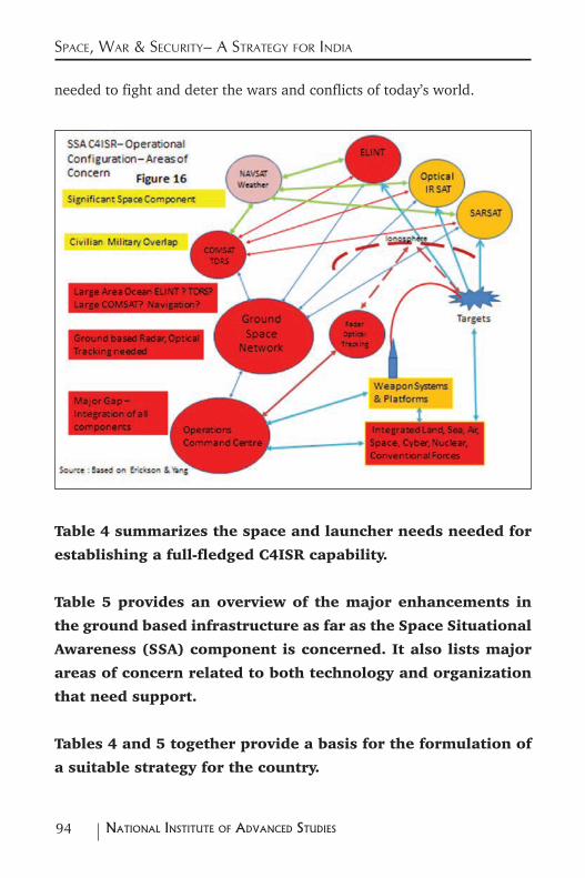
94 NatioNal iNstitute of advaNced studies
Space, War & Security– a Strategy for india
needed to fight and deter the wars and conflicts of today’s world.
Table 4 summarizes the space and launcher needs needed for
establishing a full-fledged C4ISR capability.
Table 5 provides an overview of the major enhancements in
the ground based infrastructure as far as the Space Situational
Awareness (SSA) component is concerned. It also lists major
areas of concern related to both technology and organization
that need support.
Tables 4 and 5 together provide a basis for the formulation of
a suitable strategy for the country.
95NatioNal iNstitute of advaNced studies
Space, War & Security– a Strategy for india
8.2 Key Components of a Space Strategy
Satellites & Launchers
From Table 4 it is clear that India needs four Advanced Communications
Satellites, one Tracking & Data Relay Satellite as well as at least one
Navigation satellite to be launched into GSO every year. All these
satellites would fall in the medium to intermediate class of GSO
satellites that will need a GSLV launch. Equipped with ion propulsion
capabilities they can perform the same functions as the current
generation of heavy satellites.
The ELINT part of the ISR function requires the simultaneous launch of
three satellites. This may also require a dedicated GSLV launch.
Taken together this translates into a demand for about 9
advanced communications type satellites and 7 GSLV launchers
every year.
In addition to these largely communications and electronic signals payloads,
one weather satellite with a mass of about 2000 Kg may also need to be
launched into GSO every three years to meet operational weather needs.
The orbiting component of the weather service may need the capacity to
build one weather satellite every year. This may also need a dedicated PSLV
launch.
To meet both civilian and military remote sensing needs India may also
need to build and launch 2 EO satellites as well as 2 SAR satellites a year.
This will need four PSLV launches per year.
96 NatioNal iNstitute of advaNced studies
Space, War & Security– a Strategy for india
The creation of LEO constellations for both C4 and ISR needs over a two
to three year period for validating its utility for C4ISR functions will need
the launching of 28 small satellites in the 100 to 200 Kg class every year.
Seven PSLV launches and two launches of a modified Agni 5 missile may
be needed for this purpose.
In addition to meeting the mainstream C4ISR requirements,
PSLV launches may also be needed for establishing an orbiting
constellation of 24 navigation satellites. About 3 satellites
per year may need to be built and launched into MEO (20000
Km) for establishing a completely independent space based
navigation service catering to both military and civilian users.
This will require 3 dedicated PSLV launchers every year. With
this launch rate a completely indigenous state-of-art navigation
service could become available in ten years.
Adding all the numbers India may need to launch about 17 advanced
satellites in addition to about 28 small satellites for meeting the
operational C4ISR requirements. This will require 7 GSLV launches,
15 PSLV launches and two modified Agni 5 launches.
The promotion of the small satellite initiative to create
national capability will need the establishment of very small
satellite building capabilities in a number of educational and
research institutions. One dedicated PSLV launch along with
five launches of the Agni 5 modified missile launcher per year
may be needed for this purpose.
We can see that a significant augmentation of satellite and
launcher capacities may be needed to meet these requirements.
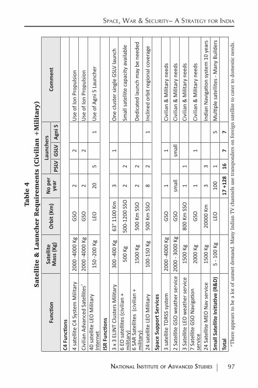
97NatioNal iNstitute of advaNced studies
Space, War & Security– a Strategy for indiaTa
ble
4
Sate
llit
e &
Lau
nch
er R
equ
irem
ents
(C
ivil
ian
+M
ilit
ary
)
Func
tion
Sate
llite
M
ass
(Kg)
Orb
it (K
m)
No
per
year
Laun
cher
sCo
mm
ent
PSLV
GSL
V
Agn
i 5
C4 F
uncti
ons
4 sa
telli
te C
4 Sy
stem
Mili
tary
2000
-400
0 Kg
GSO
22
Use
of I
on P
ropu
lsion
Civi
lian
Adva
nced
Sat
ellit
es*
2000
-400
0 Kg
GSO
22
Use
of I
on P
ropu
lsion
40 sa
telli
te L
EO M
ilita
ry
Inte
rnet
150
-200
Kg
LEO
205
1U
se o
f Agn
i 5 L
aunc
her
ISR
Func
tion
s
3 x
3 EL
INT
Clus
ters
Mili
tary
300
-400
Kg
63° 1
100
Km3
1O
ne c
lust
er si
ngle
GSL
V la
unch
6 EO
sate
llite
s (ci
vilia
n +
mili
tary
)50
0 Kg
500-
1200
SSO
22
Smal
l sat
ellit
e ca
paci
ty a
vaila
ble
6 SA
R Sa
telli
tes
(civ
ilian
+
mili
tary
)15
00 K
g50
0 Km
SSO
22
Dedi
cate
d la
unch
may
be
need
ed
24 sa
telli
te L
EO M
ilita
ry10
0-15
0 Kg
500
Km S
SO8
21
Incl
ined
orb
it re
gion
al c
over
age
Spac
e Su
ppor
t Ser
vice
s
3 sa
telli
te T
DRSS
syst
em20
00 -4
000
KgGS
O1
1Ci
vilia
n &
Mili
tary
nee
ds2
Sate
llite
GSO
wea
ther
serv
ice
2000
- 30
00 K
gGS
Osm
all
smal
lCi
vilia
n &
Mili
tary
nee
ds3
Sate
llite
LEO
wea
ther
serv
ice
1500
Kg
800
Km S
SO1
1Ci
vilia
n &
Mili
tary
nee
ds7
Sate
llite
GSO
Nav
igati
on
serv
ice
2000
Kg
GSO
11
Civi
lian
& M
ilita
ry n
eeds
24 S
atel
lite
MEO
Nav
serv
ice
1500
Kg
2000
0 Km
33
Indi
an N
avig
ation
syst
em 1
0 ye
ars
Smal
l Sat
ellit
e In
itiati
ve (R
&D
)5
- 100
Kg
LEO
10
01
5M
ultip
le sa
telli
tes -
Man
y Bu
ilder
s To
tal
17 +
128
167
7*T
here
app
ears
to
be a
lot
of u
nmet
dem
and.
Man
y In
dian
TV
cha
nnel
s us
e tr
ansp
onde
rs o
n fo
reig
n sa
telli
te t
o ca
ter
to d
omes
tic
need
s.
98 NatioNal iNstitute of advaNced studies
Space, War & Security– a Strategy for india
To provide a comparison India can currently build and
launch about four advanced satellites a year along with their
launchers. To go from the current capacity of four satellites and
launchers to the required 17 satellites along with their launch
requirements would need the capacity to increase four fold. If
the small satellite constellation needs are added the satellite
and launch capacities need to be multiplied at least five times
to meet just the C4ISR needs of an aspiring space power.
One route for achieving this is to increase capacities within the
current entities developing building and launching satellites.
The other way is to make sure that through appropriate
mechanisms the capacity for building and launching satellites
is created within Indian industry.
Most if not all advanced powers have all created vibrant and
globally competitive space industries within their economies.
This looks like the logical route for India to follow.
Critical Areas – Infrastructure, Technologies, Organization
As covered earlier the other immediate requirement and a vital component
of any space strategy for India relates to Space Situational Awareness
(SSA).
India needs to create a suitable network of long range radars
that could track space objects.
A network of optical tracking and laser ranging stations would
99NatioNal iNstitute of advaNced studies
Space, War & Security– a Strategy for india
complement and enhance the capabilities of the radar network.
Apart from the creation of this infrastructure, India also
needs to identify suitable entities within the National Security
complex that would be responsible for the routine monitoring
of the space environment.
A deeper study of orbital motions around the earth can also
benefit a number of scientific domains such as geodesy and
astronomy. Such a programme should be supported at a
number of locations.
In addition to this SSA capabilities that is crucial for India there are also a
number of other areas of concern.
These comprise technologies, organization initiatives, integration issues to
create a network centric capability as well as issues of strategy and doctrine.
Table 5 provides details of these areas of concern. A space
strategy for India should address these needs so that current
gaps can be eliminated and future options for action are
preserved.
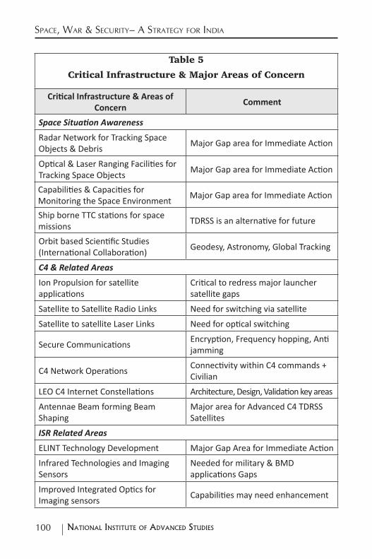
100 NatioNal iNstitute of advaNced studies
Space, War & Security– a Strategy for india
Table 5
Critical Infrastructure & Major Areas of Concern
Critical Infrastructure & Areas of Concern
Comment
Space Situation Awareness
Radar Network for Tracking Space Objects & Debris Major Gap area for Immediate Action
Optical & Laser Ranging Facilities for Tracking Space Objects Major Gap area for Immediate Action
Capabilities & Capacities for Monitoring the Space Environment Major Gap area for Immediate Action
Ship borne TTC stations for space missions TDRSS is an alternative for future
Orbit based Scientific Studies (International Collaboration) Geodesy, Astronomy, Global Tracking
C4 & Related Areas
Ion Propulsion for satellite applications
Critical to redress major launcher satellite gaps
Satellite to Satellite Radio Links Need for switching via satellite
Satellite to satellite Laser Links Need for optical switching
Secure Communications Encryption, Frequency hopping, Anti jamming
C4 Network Operations Connectivity within C4 commands + Civilian
LEO C4 Internet Constellations Architecture, Design, Validation key areas
Antennae Beam forming Beam Shaping
Major area for Advanced C4 TDRSS Satellites
ISR Related Areas
ELINT Technology Development Major Gap Area for Immediate Action
Infrared Technologies and Imaging Sensors
Needed for military & BMD applications Gaps
Improved Integrated Optics for Imaging sensors Capabilities may need enhancement
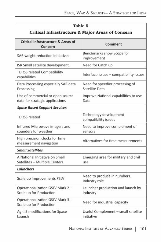
101NatioNal iNstitute of advaNced studies
Space, War & Security– a Strategy for india
Table 5
Critical Infrastructure & Major Areas of Concern
Critical Infrastructure & Areas of Concern
Comment
SAR weight reduction initiatives Benchmarks show Scope for improvement
ISR Small satellite development Need for Catch up
TDRSS related Compatibility capabilities Interface issues – compatibility issues
Data Processing especially SAR data Processing
Need for speedier processing of Satellite Data
Use of commercial or open source data for strategic applications
Improve National capabilities to use Data
Space Based Support Services
TDRSS related Technology development compatibility issues
Infrared Microwave imagers and sounders for weather
Need to improve complement of sensors
High precision clocks for time measurement navigation Alternatives for time measurements
Small Satellites
A National Initiative on Small Satellites – Multiple Centers
Emerging area for military and civil use
Launchers
Scale up Improvements PSLV Need to produce in numbers. Industry role
Operationalization GSLV Mark 2 – Scale up for Production
Launcher production and launch by industry
Operationalization GSLV Mark 3 - Scale up for Production Need for industrial capacity
Agni 5 modifications for Space Launch
Useful Complement – small satellite initiative
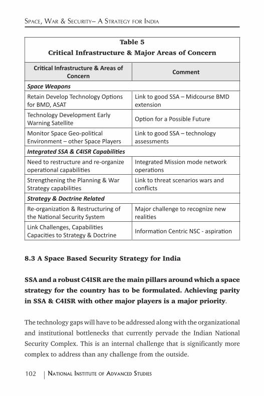
102 NatioNal iNstitute of advaNced studies
Space, War & Security– a Strategy for india
Table 5
Critical Infrastructure & Major Areas of Concern
Critical Infrastructure & Areas of Concern
Comment
Space Weapons
Retain Develop Technology Options for BMD, ASAT
Link to good SSA – Midcourse BMD extension
Technology Development Early Warning Satellite Option for a Possible Future
Monitor Space Geo-political Environment – other Space Players
Link to good SSA – technology assessments
Integrated SSA & C4ISR Capabilities
Need to restructure and re-organize operational capabilities
Integrated Mission mode network operations
Strengthening the Planning & War Strategy capabilities
Link to threat scenarios wars and conflicts
Strategy & Doctrine Related
Re-organization & Restructuring of the National Security System
Major challenge to recognize new realities
Link Challenges, Capabilities Capacities to Strategy & Doctrine Information Centric NSC - aspiration
8.3 A Space Based Security Strategy for India
SSA and a robust C4ISR are the main pillars around which a space
strategy for the country has to be formulated. Achieving parity
in SSA & C4ISR with other major players is a major priority.
The technology gaps will have to be addressed along with the organizational
and institutional bottlenecks that currently pervade the Indian National
Security Complex. This is an internal challenge that is significantly more
complex to address than any challenge from the outside.
103NatioNal iNstitute of advaNced studies
Space, War & Security– a Strategy for india
Major structural changes in the connections between space assets,
nuclear war and conventional war may be needed. The role of
space assets via the C4ISR route should be the driver of this re-
organization. Only such restructuring will enable India to cope
with emerging developments of the current geo-political order.
Though India can build and operate medium and intermediate class multi-
functional Communications satellites in GSO it may need to augment its
capacity to build such satellites. While dual use civil-military systems can
provide military services to some extent, India may need to provide satellite
networks dedicated for military use. There are gaps in both capabilities
and capacities for meeting these needs. The use of Ion propulsion
technology is one way to redress both the satellite and
launcher gap and move India from its current intermediate
class position towards the heavy satellite class position. This
should form a key part of India’s space strategy to ensure that the launcher
and satellite programmes finally converge into a total indigenous capability.
Constellations of smaller orbiting satellites that connect with each other
promise to both complement and compete with the more traditional GSO
based network services. They could also provide very useful connectivity
services during times of crisis. India has no experience with the building
and operations of such networks. These capabilities and capacities have to
be created both within the official National Security Complex as well as
within industry and Universities.
Satellite to satellite switching, Laser communications, secure communica-
tions are key technology areas for sustained initiatives.
India has so far not launched and operated an ELINT cluster.
This is a key requirement even for a limited regional ISR.
104 NatioNal iNstitute of advaNced studies
Space, War & Security– a Strategy for india
Eliminating this gap must be taken up on a priority basis.
While India can currently build, launch and operate both SAR
and optical imaging satellites that are adequate for meeting
most ISR needs it does not have in place the needed capacities
and supply chains for producing them and launching them in
the required numbers.
Indian capabilities for dealing with the infra-red (thermal) part
of the spectrum are very limited.97 These need to be strengthened
significantly. Apart from ISR they are used for performing many other military
functions and could play an important part in any future BMD system.
Improved Integrated Electro-optical systems for high resolution
imaging is crucial for ensuring state-of-art capabilities in space
based imaging. Weight reduction initiatives for SAR and speedier
processing of SAR (ISR) data are other gaps that have to be
closed for improved state-of-art operations of the ISR system.
The current mode of using onboard storage and a network of
suitably located ground stations is adequate for collecting ISR
data over the Indian region. This may also be adequate for
meeting immediate operational needs. However given the nature
of the geography of the Asia Pacific Region India may soon have
to move towards creating TDRSS assets in space. This will also
require augmenting Indian capacities to build and operate large multiple
beam satellites in GSO that are connected to other GSO and orbiting satellites.
97 One Bangalore based startup company seems to be making an impact on the global market for night vision cameras. See Peerzada Abrar “Night-vision startup Tonbo bags multimillion dollar contracts”, The Hindu, Business Section, Saturday 14 November 2015.
105NatioNal iNstitute of advaNced studies
Space, War & Security– a Strategy for india
Advanced Communications Satellites, SAR satellites as well as
TDRSS satellites along require advanced antennae as well as
beam forming and beam shaping technologies. This is another
area requiring significant strengthening.
Small satellites that are built in numbers and launched in constellations
also promise to compete with larger custom built satellites that provide ISR
capabilities. As in the case of C4 services small satellite constellations
could provide valuable ISR data in times of crisis. This again is an
area where India lacks capabilities as well as capacities.
Commercial satellite imagery suppliers currently provide high
quality data that could cater to many military needs. However
though there is a large amount of data available India does
not have enough capacities to use this data to feed into its
ISR needs. A significant augmentation of capacities to use this
data within the national security complex is needed. There is also
a major national need to create such capacities within industry, research
centers and universities. Creating a pool of expertise within the country
that uses space imagery for meeting a variety of strategic needs, would
contribute in a major way towards enhancing India’s security interests.
Indian capabilities in building and operating meteorological
satellites in GSO that support C4ISR operations are substantial.
However India has so far not built any polar orbiting weather
satellites. If the focus is regional the GSO based assets may be adequate.
However if the focus is global the GSO assets may need to be augmented
with an orbiting network.
Integration of global openly available weather data with Indian data that
caters to the needs of the Indian establishments could be one area of concern.
106 NatioNal iNstitute of advaNced studies
Space, War & Security– a Strategy for india
The development of more region specific micro level weather models may
also be needed. Capacities for doing this have to be created both within the
government establishments as well as in industry and academia.
The global trend seems to be moving away from dedicated meteorological
satellites for military use towards one where military and civilian services
are provided via the same set of satellites. Current Indian arrangements are
already operating on such a premise. These arrangements may need to be
strengthened suitably to take care of military and security needs.
The IRNSS that India is putting in place for providing navigation
services for both civilian and military use is based upon a
combination of geostationary and geosynchronous satellites.
This architecture is very different from the architectures of the
systems being established by the other major space powers.
Over the next ten years India may have to add a complement
of orbiting satellites in a phased way to improve accuracies.
By adopting this route India may be able to get to a completely
indigenous navigation system within the next ten years.
The current arrangement of meeting both civilian and military navigation
needs through the same system is in tune with global trends and may not
require any major restructuring or reorganizing.
National capabilities to build small satellites need to be
strengthened through a small satellite initiative.
The role of PSLV as a reliable launcher for meeting ISR requirements has
been well established. Its ability to launch multiple smaller satellites has
also been proven. Capacities for building and launching more
PSLVs need to be created to cater to the increasing demand.
107NatioNal iNstitute of advaNced studies
Space, War & Security– a Strategy for india
Indian industry must build the capacities needed.
As we had mentioned earlier Indian GSO C4 satellites have to move from
an intermediate class to a heavy class. Significant delays in the realization
of the GSLV Mark 2 and the GSLV Mark 3 launchers has further worsened
the gap between Indian and global C4 capabilities. The use of ion propulsion
technology to move the satellite from GTO to GSO reduces the fuel
requirements onboard the C4 satellites significantly. Thus the medium class
capabilities of the GSLV Mark 2 can launch intermediate class satellites and
the GSLV Mark 3 that is under development can launch the heavy class
satellites that are currently state-of art. The use of ion propulsion
technology therefore promises to redress both the C4 satellite
as well as the launcher gap between India and the rest of the
world. Forcing this integration between launcher and satellite
capabilities via the ion propulsion route should be a major
component of the space strategy of the country. Here also most
capacity additions have to happen in Indian industry.
The minor modifications that are needed to convert the Agni 5
into a space launcher for smaller satellites have to be carried
out on a crash basis. The capability to launch satellites from different
locations within the country to cater to the increasing demand for such
satellites must also be established expeditiously. The production plans for
the Agni 5 should be drawn up keeping these needs in mind.
The space strategy of the country should also support a limited
space weapons development programme (BMD & ASAT) that
will keep technology options open for the future.
Integration of the operational part of the capability realized
through the SSA and C4ISR Integration with the strategy and
108 NatioNal iNstitute of advaNced studies
Space, War & Security– a Strategy for india
doctrine part of a national strategy is obviously the most
important organizational and institutional challenge facing the
country. Without the aspiration of wanting to be a power that
matters and a clear intent of reforming and re-structuring the
existing setup the rest of the strategy including the technology
capabilities that may be built up makes no sense.
All the capabilities including those on space weapons outlined
in Table 5 are consistent with India’s current global posture of
“peaceful uses of outer space”.
Achieving these capabilities will take India a period of about
ten years of major effort. More than the monetary resources
the internal challenges from powerful organizational and
institutional lobbies will the major hurdles to overcome.
India may also have to make some hard choices on the
tradeoffs between the efforts required to put a man in space
and its associated benefits vis a vis the requirements to build
a robust space based network centric war deterring capability.
Doing both of them simultaneously may not be possible given
the resources that are currently available in the country. More
than money, the human and organizational resource base is
likely to be the main problem area.
Irrespective of whether India eventually choses to be a pro-
active or a reactive player, the creation of a strong national
SSA and C4ISR capability is a minimum requirement for an
aspiring power like India. In the Realpolitik world of today
no country that aspires to be counted can afford to ignore the
109NatioNal iNstitute of advaNced studies
Space, War & Security– a Strategy for india
power that comes about through a robust SSA and a C4ISR
capability in which space assets will play the key role.
Once a country has a strong SSA & C4ISR capability it can
then chose to use this as a force multiplier for either a pro-
active (offensive) or reactive (defensive) strategy. This directly
connects the SSA& C4ISR capabilities to the role and use of
space weapons and its implications for India.
While technology options can be kept open on space weapons as
well as on the manned space programme operational decisions
on these can be deferred by a few years till a robust SSA &
C4ISR capability has been built up in the country. India can then
address the global challenges it encounters at that time in a
more pragmatic and meaningful way.
Acknowledgements
The author would like to thank all colleagues of the International Strategic
& Security Studies Programme (ISSSP) for their technical and moral
support in the writing of this paper. The author would also like to specially
thank Lalitha Sunderasan, Y.S.Rajan, V.Siddhartha and Gopal Raj for their
comments based on a critical review of the paper.
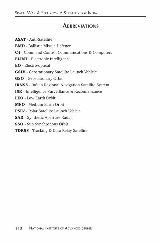
110 NatioNal iNstitute of advaNced studies
Space, War & Security– a Strategy for india
aBBreviationS
ASAT - Anti-Satellite
BMD - Ballistic Missile Defence
C4 - Command Control Communications & Computers
ELINT - Electronic Intelligence
EO - Electro-optical
GSLV - Geostationary Satellite Launch Vehicle
GSO - Geostationary Orbit
IRNSS - Indian Regional Navigation Satellite System
ISR - Intelligence Surveillance & Reconnaissance
LEO - Low Earth Orbit
MEO - Medium Earth Orbit
PSLV - Polar Satellite Launch Vehicle
SAR - Synthetic Aperture Radar
SSO - Sun Synchronous Orbit
TDRSS - Tracking & Data Relay Satellite