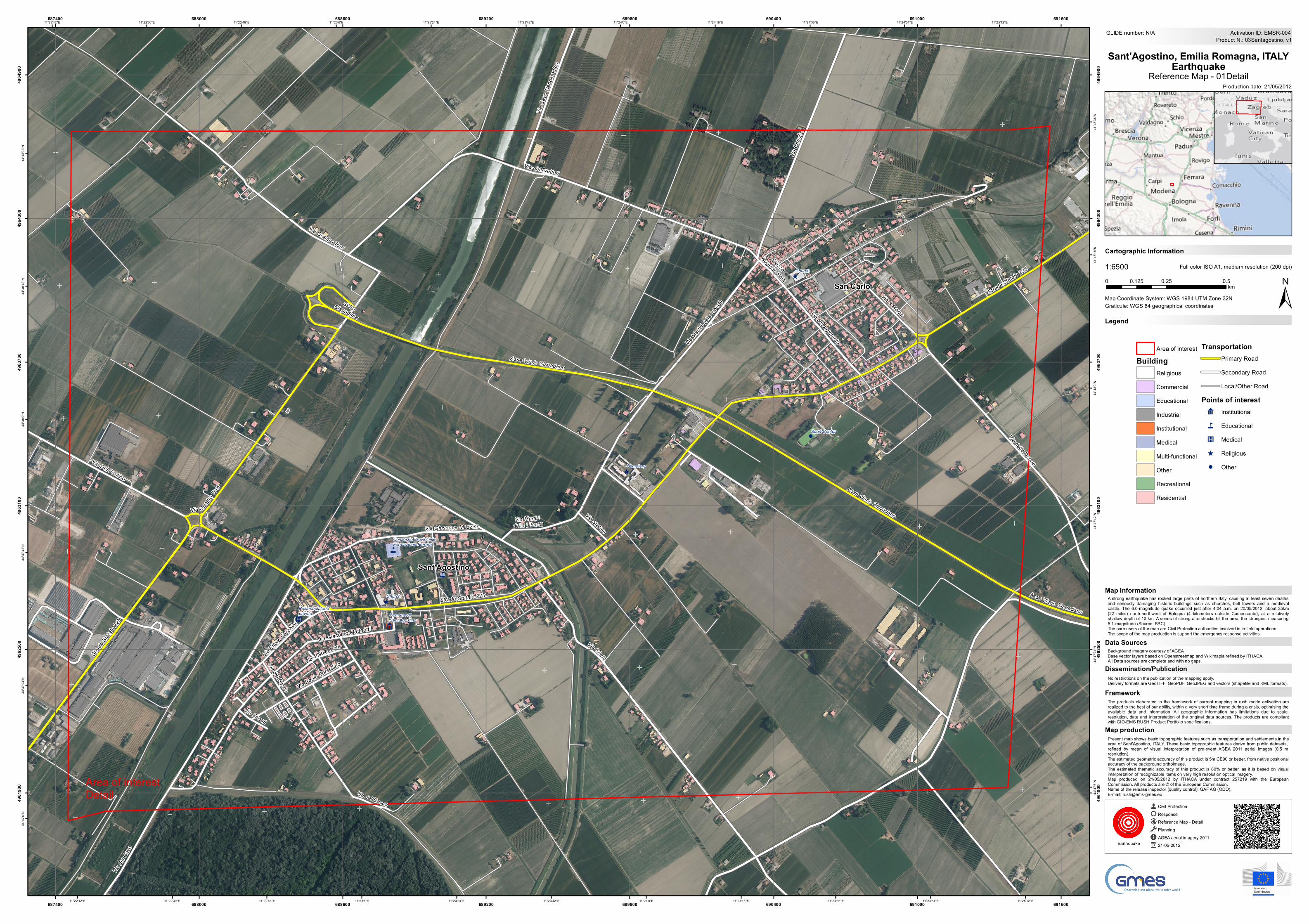
Present map shows basic topographic features such as transportation and settlements in thearea of Sant'Agostino, ITALY. These basic topographic features derive from public datasets,refined by mean of visual interpretation of pre-event AGEA 2011 aerial images (0.5 mresolution).The estimated geometric accuracy of this product is 5m CE90 or better, from native positionalaccuracy of the background orthoimage.The estimated thematic accuracy of this product is 80% or better, as it is based on visualinterpretation of recognizable items on very high resolution optical imagery.Map produced on 21/05/2012 by ITHACA under contract 257219 with the EuropeanCommission. All products are © of the European Commission.Name of the release inspector (quality control): GAF AG (ODO).E-mail: [email protected]
Area of interestBuilding
ReligiousCommercialEducationalIndustrialInstitutionalMedicalMulti-functionalOtherRecreationalResidential
TransportationPrimary RoadSecondary RoadLocal/Other Road
Points of interest9 Institutional
4 Educational
K Medical
^ Religious! Other
4
K
4
9
^
^
^
!
Via Ciarle
Via del Bosco
Via Giacomo Matteotti
Via Fenati
Via dei Frutteti
Piazza
Augusto PolaVia Statale
Via 8 Marzo
Via Marti
ri della
Libert
à
Via Paolo BorsellinoVia 4 Novembre
Via Giuseppe Mazzini
Via Ettore Facc
hini
Via Martiri della Libertà
Via Quattro Torri
Via Risorgimento
Via del Bosco
Via Ca
vo Na
poleo
nico
Via Del Fantino
Via Ch
iesa
Via delle Donne
Via de
l Cavo
Strada Statale 225
Via Quattro
Torri
SP70 Cispadana
Asse Viario Cispadano
Asse Viario Cispadano
Strada Statale 225
Strada
Statale
225
Asse Viario Cispadano
Sant'Agostino
San Carlo
Church
Consorzio ProvincialeFormazione Ferrara
Cemetery
Poliambulatorioprivato Comune di
Sant'Agostino
Sport Center
Church
11°25'12"E
11°25'12"E
11°24'54"E
11°24'54"E
11°24'36"E
11°24'36"E
11°24'18"E
11°24'18"E
11°24'0"E
11°24'0"E
11°23'42"E
11°23'42"E
11°23'24"E
11°23'24"E
11°23'6"E
11°23'6"E
11°22'48"E
11°22'48"E
11°22'30"E
11°22'30"E
11°22'12"E
11°22'12"E44
°48'3
6"N
44°4
8'36"N
44°4
8'18"N
44°4
8'18"N
44°4
8'0"N
44°4
8'0"N
44°4
7'42"N
44°4
7'42"N
44°4
7'24"N
44°4
7'24"N
44°4
7'6"N
44°4
7'6"N
687400
687400
688000
688000
688600
688600
689200
689200
689800
689800
690400
690400
691000
691000
691600
691600
4961
900
4961
900
4962
500
4962
500
4963
100
4963
100
4963
700
4963
700
4964
300
4964
300
4964
900
4964
900
GLIDE number: N/A
Production date: 21/05/2012
Cartographic Information
1:6500
±Map Coordinate System: WGS 1984 UTM Zone 32N
Full color ISO A1, medium resolution (200 dpi)
The products elaborated in the framework of current mapping in rush mode activation arerealized to the best of our ability, within a very short time frame during a crisis, optimising theavailable data and information. All geographic information has limitations due to scale,resolution, date and interpretation of the original data sources. The products are compliantwith GIO-EMS RUSH Product Portfolio specifications.
No restrictions on the publication of the mapping apply.Delivery formats are GeoTIFF, GeoPDF, GeoJPEG and vectors (shapefile and KML formats).
A strong earthquake has rocked large parts of northern Italy, causing at least seven deathsand seriously damaging historic buildings such as churches, bell towers and a medievalcastle. The 6.0-magnitude quake occurred just after 4:04 a.m. on 20/05/2012, about 35km(22 miles) north-northwest of Bologna (4 kilometers outside Camposanto), at a relativelyshallow depth of 10 km. A series of strong aftershocks hit the area, the strongest measuring5.1-magnitude (Source: BBC)The core users of the map are Civil Protection authorities involved in in-field operations.The scope of the map production is support the emergency response activities.
LegendGraticule: WGS 84 geographical coordinates
Product N.: 03Santagostino, v1Activation ID: EMSR-004
Background imagery courtesy of AGEABase vector layers based on Openstreetmap and Wikimapia refined by ITHACA.All Data sources are complete and with no gaps.
Civil ProtectionResponseReference Map - DetailPlanningAGEA aerial imagery 201121-05-2012Earthquake
0 0.25 0.50.125km
Sant'Agostino, Emilia Romagna, ITALYEarthquake
Reference Map - 01Detail
Map production
Framework
Dissemination/Publication
Data Sources
Map Information
Area of interestDetail


