FEATURES ■ Guided shale workflow ■ Petroleum systems 1D modeling ■ Play chance mapping to evaluate
chance of success ■ Regional multiwell correlation
including digital and raster logs ■ Seismic interpretation and mapping
with surface and volume attributes ■ Intuitive well positioning
and design tools ■ Efficient field-level pad planning tools ■ Real-time geosteering ■ Microseismic visualization ■ Dynamic production mapping ■ Intuitive filtering and searching
through historical data ■ Multiuser database access,
subscriptions, and notifications enabling collaboration among asset team
BENEFITS ■ Single platform for all shale workflows ■ Work with tens of thousands
of wells in a 3D canvas ■ Identify the best acreage through
play chance mapping ■ Create fast maps and easily
regenerate them with new data ■ Identify your sweet spots ■ Efficiently generate multiple well
plans and scenarios to optimize field development
■ Steer wells in real time ■ Analyze production data in context
of geology ■ Collaborate with all members of your
asset team through a multiuser database
Petrel* Shale is the industry’s first end-to-end software from exploration to production designed specifically for shale. The new user interface and toolset is customized for efficient geological and geophysical map-based evaluations, streamlined well planning and completions decision making to effectively support operations in this unique operating environment.
Petrel Shale allows geoscientists to seamlessly integrate geological, geophysical, and production data to efficiently define sweet spots, automatically plan well locations, and analyze production trends. It leverages the Petrel E&P software platform to offer reliability, technology, and innovation, in a fit-for-shale solution.
With a user interface and tool-set specifically designed to maximize productivity and efficiency, Petrel Shale spans the five key themes common to shale workflows: explore, evaluate, drill, complete, and produce.
This offers the ability to visualize and work with a large variety of high-density data, in both 2D and 3D, which delivers a modern, high-performance environment designed for shale operations.
Petrel ShaleEnd-to-end workflows from exploration to production, specifically designed for shale
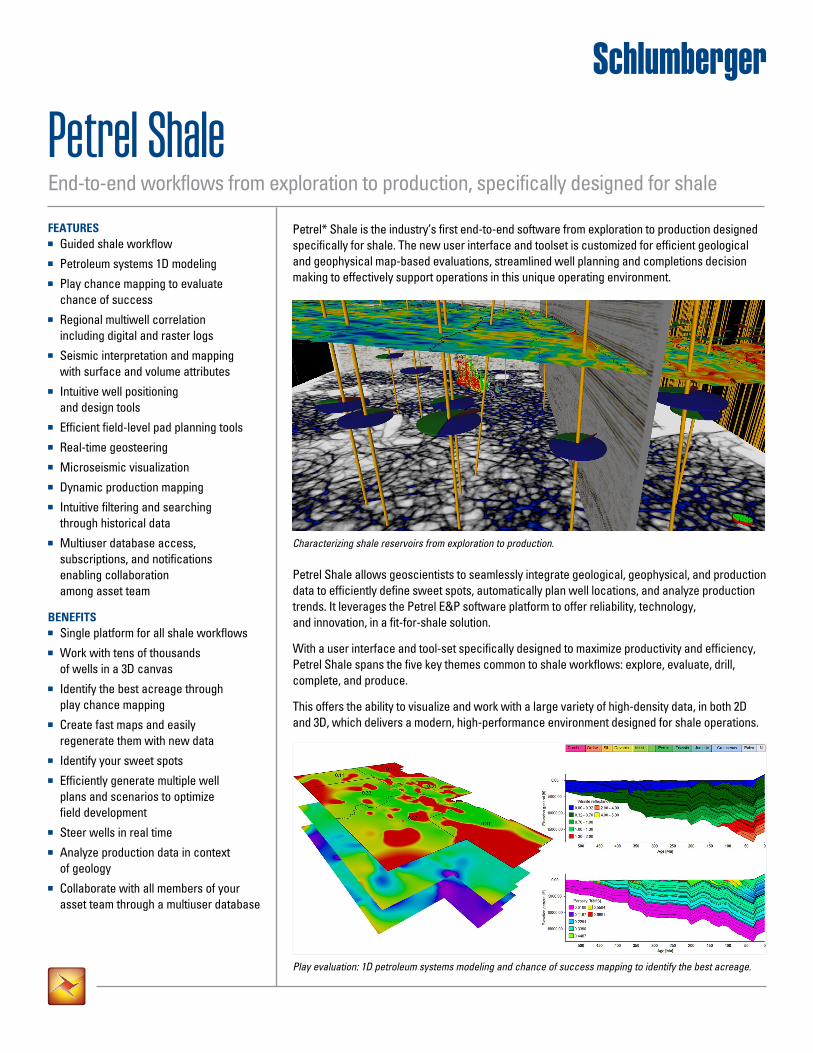
Characterizing shale reservoirs from exploration to production.
Play evaluation: 1D petroleum systems modeling and chance of success mapping to identify the best acreage.
Explore and identify the best acreageSelecting the right acreage is critical for success in shale plays. The exploration tools built into Petrel Shale enables rapid initial exploration screening workflows, helping to determine which acreage to pursue. The 1D petroleum systems modeling simulation tool enables contextual understanding of the burial history, source rock maturation, hydrocarbon expulsion potential, and changes to properties over time from a wellbore perspective. Using the play chance mapping functionality, property maps of play elements are transformed
Petrel Shale
to chance-of-success (COS) maps, and combined to provide an overall COS. Crucially, with the seamless integration across this workflow, COS maps can be readily updated with changes to play element maps—keeping your COS maps alive.
Additionally, shale operations often require enhanced performance to deal with large quantities of data. With significant improvements to well performance, it is possible to work easily with 10,000s of wells and log data in the 2D, 3D and well section canvases.
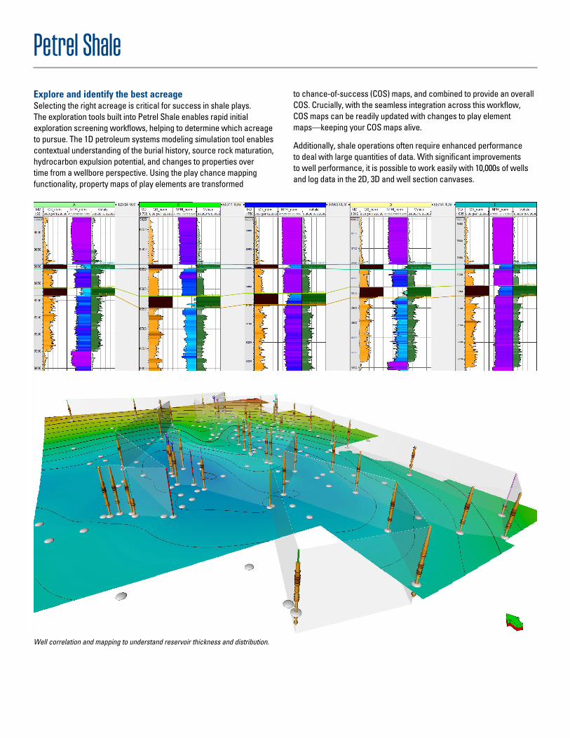
Well correlation and mapping to understand reservoir thickness and distribution.
Geology and well correlationData consumption in shale plays requires coupling knowledge of the wellbore with regional well correlation and mapping. Petrel Shale provides streamlined workflows to create maps and cross-well interpretations in context of local and regional data.
The correlation tools provide flexibility to rapidly interpret and validate stratigraphic markers using both raster and digital logs. Additionally, isochores can be easily generated and mapped to understand reservoir extent. Both public- and company-specific GIS map services can be streamed, providing geologists with access to other data such as topography, magnetics, and cultural data. As new data is acquired, maps can be easily regenerated to provide quick updates.
Integrated well planning and drillingTo operate viably in shale plays, drilling plans need to consider the best areas to drill based on reservoir quality and proximity to existing surface constraints while enabling quick, real-time updates based on new or evolving information. Petrel Shale contains a multitude of tools that are utilized across the entire well planning and drilling workflow.
Pad placement provides an automated solution to optimize well pad locations based on surface constraints such as roads, rivers, proximity to facilities, and available lease acreage, as well as taking into account various reservoir-level quality targets. Type production curves can also be incorporated into the pad placement workflow, enabling the ability to evaluate the impact of different development scenarios given different acreage holding and well placement possibilities.
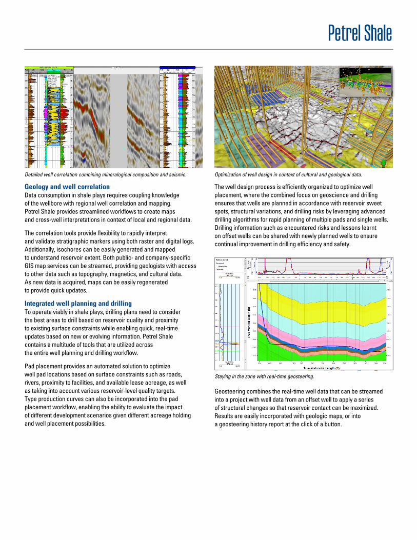
The well design process is efficiently organized to optimize well placement, where the combined focus on geoscience and drilling ensures that wells are planned in accordance with reservoir sweet spots, structural variations, and drilling risks by leveraging advanced drilling algorithms for rapid planning of multiple pads and single wells. Drilling information such as encountered risks and lessons learnt on offset wells can be shared with newly planned wells to ensure continual improvement in drilling efficiency and safety.
Geosteering combines the real-time well data that can be streamed into a project with well data from an offset well to apply a series of structural changes so that reservoir contact can be maximized. Results are easily incorporated with geologic maps, or into a geosteering history report at the click of a button.
Petrel Shale
Detailed well correlation combining mineralogical composition and seismic. Optimization of well design in context of cultural and geological data.
Staying in the zone with real-time geosteering.
software.slb.com/Petrel-Shale
Petrel Shale
*Mark of Schlumberger. Copyright © 2014 Schlumberger. All rights reserved. 14-IS-0319
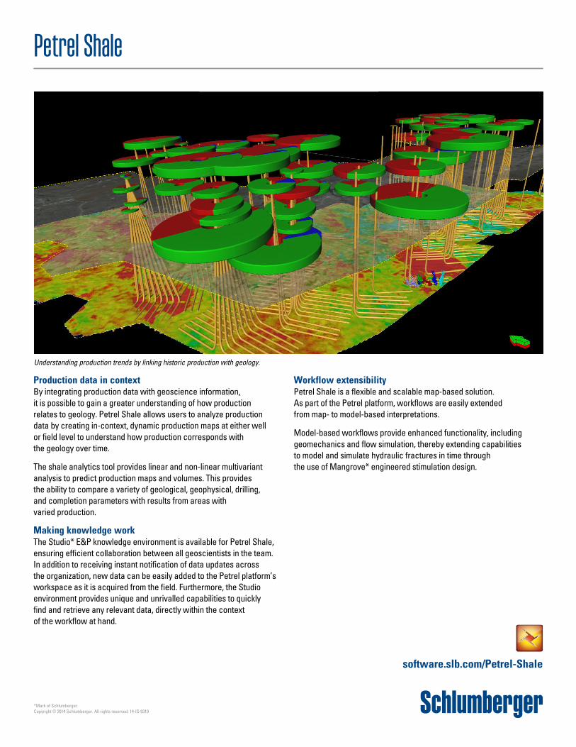
Production data in contextBy integrating production data with geoscience information, it is possible to gain a greater understanding of how production relates to geology. Petrel Shale allows users to analyze production data by creating in-context, dynamic production maps at either well or field level to understand how production corresponds with the geology over time.
The shale analytics tool provides linear and non-linear multivariant analysis to predict production maps and volumes. This provides the ability to compare a variety of geological, geophysical, drilling, and completion parameters with results from areas with varied production.
Making knowledge workThe Studio* E&P knowledge environment is available for Petrel Shale, ensuring efficient collaboration between all geoscientists in the team. In addition to receiving instant notification of data updates across the organization, new data can be easily added to the Petrel platform’s workspace as it is acquired from the field. Furthermore, the Studio environment provides unique and unrivalled capabilities to quickly find and retrieve any relevant data, directly within the context of the workflow at hand.
Workflow extensibility Petrel Shale is a flexible and scalable map-based solution. As part of the Petrel platform, workflows are easily extended from map- to model-based interpretations.
Model-based workflows provide enhanced functionality, including geomechanics and flow simulation, thereby extending capabilities to model and simulate hydraulic fractures in time through the use of Mangrove* engineered stimulation design.
Understanding production trends by linking historic production with geology.


