Instituciones participantes/ Participating Institutions
The Field Museum
Centro para el Desarrollo del Indígena Amazónico (CEDIA)
Instituto de Investigaciones de la Amazonía Peruana (IIAP)
Servicio Nacional de Áreas Naturales Protegidas por el Estado (SERNANP)
Servicio Nacional Forestal y de Fauna Silvestre (SERFOR)
Herbario Amazonense de la Universidad Nacional de la Amazonía Peruana (AMAZ)
Museo de Historia Natural de la Universidad Nacional Mayor de San Marcos
Centro de Ornitología y Biodiversidad (CORBIDI)
Esta publicación ha sido financiada en parte por The Gordon and
Betty Moore Foundation y The Field Museum./This publication has
been funded in part by The Gordon and Betty Moore Foundation
and The Field Museum.
The Field Museum Science and Education1400 South Lake Shore DriveChicago, Illinois 60605-2496, USA T 312.665.7430 F 312.665.7433
www.fieldmuseum.org/rbi
Perú: Tapiche-B
lanco R
apid Biological and Social Inventories
TH
E F
IELD
MU
SE
UM
27 Perú: Tapiche-Blanco
27no.
....................................................................................................................................................................................................................................................................................................................................................................................................................................................................................................................
....................................................................................................................................................................................................................................................................................................................................................................................................................................................................................................................

The Field Museum Centro para el Desarrollo del Indígena Amazónico (CEDIA)
Instituto de Investigaciones de la Amazonía Peruana (IIAP)
Servicio Nacional de Áreas Naturales Protegidas por el Estado (SERNANP)
Servicio Nacional Forestal y de Fauna Silvestre (SERFOR)
Herbario Amazonense de la Universidad Nacional de la Amazonía Peruana (AMAZ)
Museo de Historia Natural de la Universidad Nacional Mayor de San Marcos
Centro de Ornitología y Biodiversidad (CORBIDI)
Perú: Tapiche-Blanco
Nigel Pitman, Corine Vriesendorp, Lelis Rivera Chávez, Tyana Wachter,
Diana Alvira Reyes, Álvaro del Campo, Giussepe Gagliardi-Urrutia, David Rivera
González, Luis Trevejo, Dani Rivera González y/and Sebastian Heilpern
editores/editors
Octubre/October 2015
Instituciones Participantes/Participating Institutions
INFORME/REPORT NO. 27
LOS INFORMES DE INVENTARIOS RÁPIDOS SON PUBLICADOS POR/
RAPID INVENTORIES REPORTS ARE PUBLISHED BY:
THE FIELD MUSEUM
Science and Education
1400 South Lake Shore Drive
Chicago, Illinois 60605-2496, USA
T 312.665.7430, F 312.665.7433
www.fieldmuseum.org
Editores/Editors
Nigel Pitman, Corine Vriesendorp, Lelis Rivera Chávez,
Tyana Wachter, Diana Alvira Reyes, Álvaro del Campo,
Giussepe Gagliardi-Urrutia, David Rivera González, Luis Trevejo,
Dani Rivera González y/and Sebastian Heilpern
Diseño/Design
Costello Communications, Chicago
Mapas y gráficas/Maps and graphics
Mark K. Johnston, Jonathan Markel y/and Blanca Sandoval Ibañez
Traducciones/Translations
Patricia Álvarez-Loayza (English-castellano), Álvaro del Campo
(English-castellano), Emily Goldman (castellano-English),
Sebastian Heilpern (castellano-English), Humberto Huaninche
Sachivo (castellano-Capanahua), Nigel Pitman (castellano-English),
Ernesto Ruelas Inzunza (English-castellano), Ruth Silva (English-
castellano) y/and Lauren Wustenberg (castellano-English)
The Field Museum es una institución sin fines de lucro exenta de
impuestos federales bajo la sección 501(c)(3) del Código Fiscal Interno./
The Field Museum is a non-profit organization exempt from federal
income tax under section 501(c)(3) of the Internal Revenue Code.
ISBN NUMBER 978-0-9828419-5-2
© 2015 por The Field Museum. Todos los derechos reservados./
© 2015 by The Field Museum. All rights reserved.
Cualquiera de las opiniones expresadas en los informes de los
Inventarios Rápidos son expresamente las de los autores y no reflejan
necesariamente las del Field Museum./Any opinions expressed in
the Rapid Inventories reports are those of the authors and do not
necessarily reflect those of The Field Museum.
Esta publicación ha sido financiada en parte por The Gordon and Betty
Moore Foundation y The Field Museum./This publication has been funded in
part by The Gordon and Betty Moore Foundation and The Field Museum.
Cita sugerida/Suggested citation
Pitman, N., C. Vriesendorp, L. Rivera Chávez, T. Wachter,
D. Alvira Reyes, Á. del Campo, G. Gagliardi-Urrutia,
D. Rivera González, L. Trevejo, D. Rivera González y/and S. Heilpern,
eds. 2015. Perú: Tapiche-Blanco. Rapid Biological and Social
Inventories Report 27. The Field Museum, Chicago.
Fotos e ilustraciones/Photos and illustrations
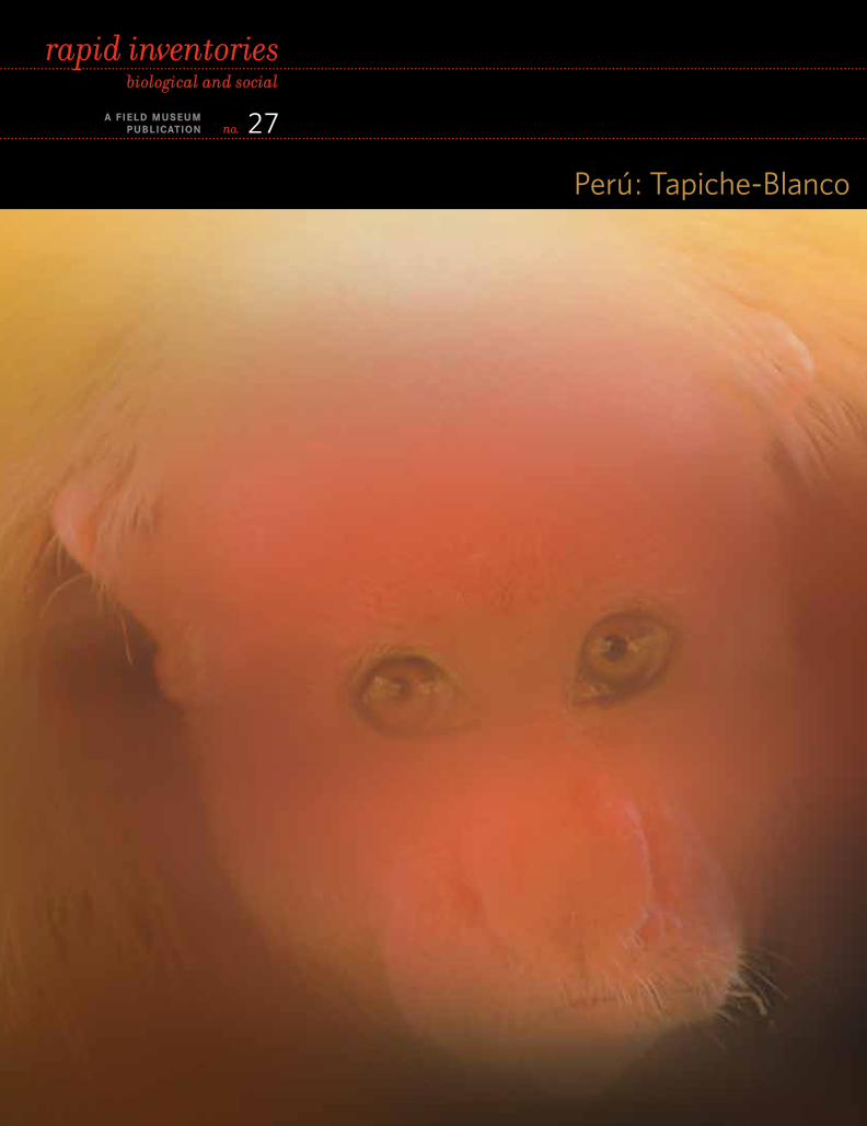
Carátula/Cover: Los bosques entre los ríos Tapiche y Blanco
albergan unas 17 especies de primates, incluyendo poblaciones
grandes del huapo rojo, Cacajao calvus ssp. ucayalii, considerado
Vulnerable en el ámbito mundial. Foto de Álvaro del Campo./
The forests of Peru’s Tapiche-Blanco region harbor some 17 species
of primates, including large populations of the globally Vulnerable
red uakari, Cacajao calvus ssp. ucayalii. Photo by Álvaro del Campo.
Carátula interior/Inner cover: Un mosaico de bosques de arena
blanca, bosques de altura y vastos humedales estacionalmente
inundables hace del interfluvio de Tapiche-Blanco una prioridad
para la conservación en el Perú. Foto de Álvaro del Campo./
With its striking mosaic of white-sand forests, upland forests, and
vast seasonally flooded wetlands, the Tapiche-Blanco region is a
leading conservation priority for Peru. Photo by Álvaro del Campo.
Láminas a color/Color plates: Figs. 10Q–S, P. Álvarez-Loayza;
Fig. 12F, D. Alvira Reyes; Fig. 10H, R. Aquino; Figs. 7A–U,
M. I. Corahua; Figs. 4D, 5C, T. Crouch; Figs. 1, 3D–F, 4F–G, 6L, 8B,
9A, 9G–H, 10A, 10C, 10G, 10J, 10K, 10M, 10O, 11B, 12A (inset),
13A–C, Á. del Campo; Figs. 10B, 10D–F, 10L, 10P, M. Escobedo;
Figs. 8A, 8G, 8J–M, 8O–P, G. Gagliardi-Urrutia; Figs. 7V, 8E, 9J,
11A, 11F, 12E, J. J. Inga Pinedo; Fig. 5A, M. K. Johnston; Figs. 2A–B,
3A–C, J. A. Markel; Fig. 5E, T. McNamara; Figs. 5G, 6A, 6C, 6D, 6G,
6J–K, T. J. Mori Vargas; Fig. 11E, C. Núñez Pérez; Fig. 8Q, M. Odicio
Iglesias; Fig. 10N, B. J. O’Shea; Fig. 7W, E. Pacaya; Figs. 11C–D,
12A–D, M. Pariona; Figs. 4B–C, N. Pitman; Figs. 9B–F, 9K,
P. Saboya del Castillo; Fig. 4A, R. F. Stallard; Figs. 6B, 6F, L. A. Torres
Montenegro; Figs. 8C–D, 8F, 8H, 8N, P. Venegas Ibáñez; Figs. 4E,
5B, 5D, 5F, 6E, 6H, C. Vriesendorp.
Impreso sobre papel reciclado. Printed on recycled paper.
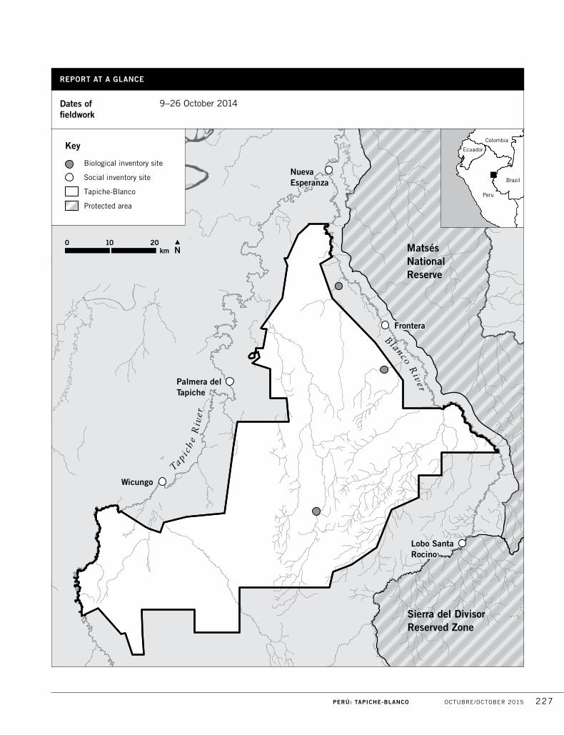
PERÚ: TAPICHE-BLANCO OCTUBRE/OCTOBER 2015 227
Dates of fieldwork
9–26 October 2014
Matsés National Reserve
Sierra del DivisorReserved Zone
Wicungo
NuevaEsperanza
Frontera
Lobo SantaRocino
Palmera delTapiche
Blanco River
Tapich
e R
iver
Biological inventory site
Social inventory site
Tapiche-Blanco
Protected area
100 20km
Colombia
Ecuador
Peru
Brazil
Key
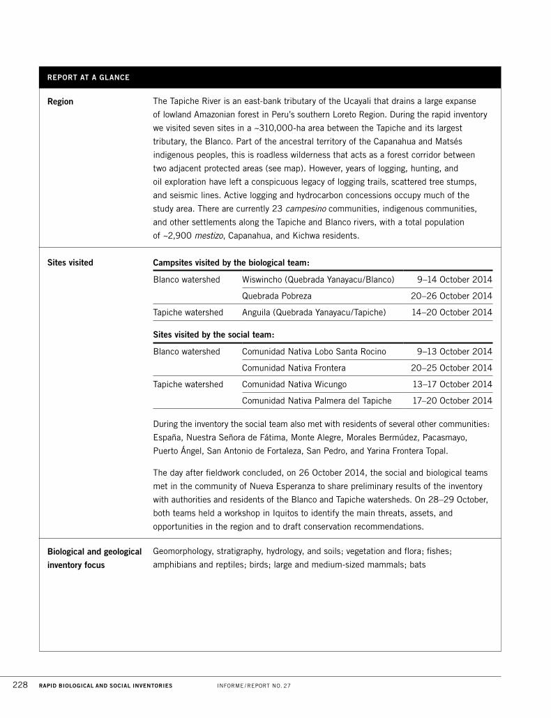
REPORT AT A GLANCE
228 RAPID BIOLOGICAL AND SOCIAL INVENTORIES INFORME / REPORT NO. 27
Region The Tapiche River is an east-bank tributary of the Ucayali that drains a large expanse
of lowland Amazonian forest in Peru’s southern Loreto Region. During the rapid inventory
we visited seven sites in a ~310,000-ha area between the Tapiche and its largest
tributary, the Blanco. Part of the ancestral territory of the Capanahua and Matsés
indigenous peoples, this is roadless wilderness that acts as a forest corridor between
two adjacent protected areas (see map). However, years of logging, hunting, and
oil exploration have left a conspicuous legacy of logging trails, scattered tree stumps,
and seismic lines. Active logging and hydrocarbon concessions occupy much of the
study area. There are currently 23 campesino communities, indigenous communities,
and other settlements along the Tapiche and Blanco rivers, with a total population
of ~2,900 mestizo, Capanahua, and Kichwa residents.
Campsites visited by the biological team:
Blanco watershed Wiswincho (Quebrada Yanayacu/Blanco) 9–14 October 2014
Quebrada Pobreza 20–26 October 2014
Tapiche watershed Anguila (Quebrada Yanayacu/Tapiche) 14–20 October 2014
Sites visited by the social team:
Blanco watershed Comunidad Nativa Lobo Santa Rocino 9–13 October 2014
Comunidad Nativa Frontera 20–25 October 2014
Tapiche watershed Comunidad Nativa Wicungo 13–17 October 2014
Comunidad Nativa Palmera del Tapiche 17–20 October 2014
Sites visited
During the inventory the social team also met with residents of several other communities:
España, Nuestra Señora de Fátima, Monte Alegre, Morales Bermúdez, Pacasmayo,
Puerto Ángel, San Antonio de Fortaleza, San Pedro, and Yarina Frontera Topal.
The day after fieldwork concluded, on 26 October 2014, the social and biological teams
met in the community of Nueva Esperanza to share preliminary results of the inventory
with authorities and residents of the Blanco and Tapiche watersheds. On 28–29 October,
both teams held a workshop in Iquitos to identify the main threats, assets, and
opportunities in the region and to draft conservation recommendations.
Biological and geological
inventory focus
Geomorphology, stratigraphy, hydrology, and soils; vegetation and flora; fishes;
amphibians and reptiles; birds; large and medium-sized mammals; bats
REPORT AT A GLANCE
PERÚ: TAPICHE-BLANCO OCTUBRE/OCTOBER 2015 229
Social inventory focus Social and cultural assets; ethnohistory; demography, economics, and natural resource
management systems; ethnobotany
Principal biological
results
The Tapiche-Blanco region epitomizes Loreto’s extraordinary landscape diversity.
It harbors large expanses of wetlands and peatland forests, white-sand forests, and
hyperdiverse upland forests, and these are drained by a variety of black, white, and
clearwater streams. Located within the global epicenter of amphibian, mammal, and
bird diversity, and highlighted by recent maps as possessing the largest aboveground
carbon stocks in Peru, the region has maintained continuous forest and a high
conservation value despite a long history of unregulated logging, hunting, and fishing.
The region has long been a conservation priority of the national and regional
governments, and the high plant and animal diversity we recorded during the inventory
make it clear that it deserves the designation.
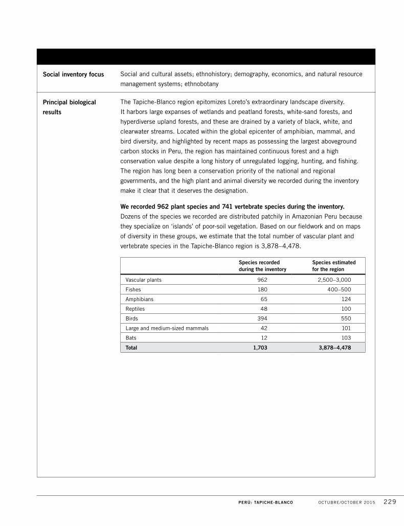
We recorded 962 plant species and 741 vertebrate species during the inventory.
Dozens of the species we recorded are distributed patchily in Amazonian Peru because
they specialize on ‘islands’ of poor-soil vegetation. Based on our fieldwork and on maps
of diversity in these groups, we estimate that the total number of vascular plant and
vertebrate species in the Tapiche-Blanco region is 3,878–4,478.
Species recorded during the inventory
Species estimated for the region
Vascular plants 962 2,500–3,000
Fishes 180 400–500
Amphibians 65 124
Reptiles 48 100
Birds 394 550
Large and medium-sized mammals 42 101
Bats 12 103
Total 1,703 3,878–4,478
230 RAPID BIOLOGICAL AND SOCIAL INVENTORIES INFORME / REPORT NO. 27
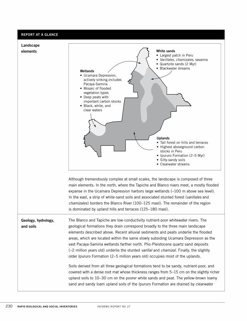
Although tremendously complex at small scales, the landscape is composed of three
main elements. In the north, where the Tapiche and Blanco rivers meet, a mostly flooded
expanse in the Ucamara Depression harbors large wetlands (~100 m above sea level).
In the east, a strip of white-sand soils and associated stunted forest (varillales and
chamizales) borders the Blanco River (100–125 masl). The remainder of the region
is dominated by upland hills and terraces (125–180 masl).
Geology, hydrology,
and soils
The Blanco and Tapiche are low-conductivity nutrient-poor whitewater rivers. The
geological formations they drain correspond broadly to the three main landscape
elements described above. Recent alluvial sediments and peats underlie the flooded
areas, which are located within the same slowly subsiding Ucamara Depression as the
vast Pacaya-Samiria wetlands farther north. Plio-Pleistocene quartz sand deposits
(~2 million years old) underlie the stunted varillal and chamizal. Finally, the slightly
older Ipururo Formation (2–5 million years old) occupies most of the uplands.
Soils derived from all three geological formations tend to be sandy, nutrient-poor, and
covered with a dense root mat whose thickness ranges from 5–15 cm on the slightly richer
upland soils to 10–30 cm on the poorer white sands and peat. The yellow-brown loamy
sand and sandy loam upland soils of the Ipururo Formation are drained by clearwater
White sands• Largest patch in Peru• Varillales, chamizales, savanna• Quartzite sands (2 Myr)• Blackwater streams
Wetlands• Ucamara Depression,
actively sinking,includes Pacaya-Samiria
• Mosaic of flooded vegetation types
• Deep peats withimportant carbon stocks
• Black, white, and clear waters
Uplands• Tall forest on hills and terraces• Highest aboveground carbon
stocks in Peru• Ipururo Formation (2–5 Myr)• Silty-sandy soils• Clearwater streams
Landscape
elements
REPORT AT A GLANCE
PERÚ: TAPICHE-BLANCO OCTUBRE/OCTOBER 2015 231
streams with very low conductivities (<10 µS/cm) and a slightly acidic pH. The white
quartz-sand soils in the varillales and chamizales are drained by blackwater, higher-
conductivity (30–50 µS/cm) and acidic (pH <4.5) streams. Water bodies in the flooded
areas are a mix of white, black, and clearwater. Salt licks (collpas) are relatively rare in the
region, but are important attractions for terrestrial mammals and hunters. A parrot collpa
of a type rarely recorded in Loreto was observed on a cliff along the Blanco River.
This is one of the most geologically active regions of the Loreto lowlands, crisscrossed
by deep and shallow faults. The most notable is the Bolognesi Fault, whose role in
elevating the uplands above the white-sand forests west of the Blanco River makes it
conspicuous on satellite images. The Blanco River itself appears to be developed
along a zone of secondary faulting, which likely led to the Blanco’s geologically recent
‘capture’ of headwaters that previously belonged to the Gálvez River.
The region’s sandy, low-nutrient soils make it especially vulnerable to large-scale
extractive activities. The root mats that currently protect the soil are easily destroyed
by road-building, deforestation, and intensive forestry. Loss of these root mats would
result in excessive upland erosion and the subsequent burial of important wetland
environments and low-lying varillales and chamizales. While the three oil wells drilled to
date in the region were dry, exploration is ongoing and constitutes a grave risk. Drilling
in the Tapiche-Blanco region could cause spills of salty formation waters or oil that
could pollute surface waters and aquatic ecosystems, an especially grave concern given
the exceedingly low levels of salts in the landscape.
Vegetation Three large blocks of vegetation dominate the landscape: wetlands, white-sand forests,
and upland forests (see map above). Within these blocks we recorded a complex
mosaic of at least five vegetation types (and eight sub-types), many of them growing
on nutrient-poor soils and featuring plant species that are poor-soil specialists.
Some poor-soil forests in the region grow on white sands and others grow on peat
deposits. The varillal and chamizal forests on white sand are very similar in structure
and composition to those in the Matsés and Allpahuayo-Mishana National Reserves,
but are dominated by different species. We also found forests that strongly resemble
varillales and that harbor a number of species typically associated with that forest type
(Pachira brevipes, Macrolobium microcalyx, Pagamea, Platycarpum sp. nov.), but
that grow on peat. These vegetation types, which we are calling peatland varillales and
chamizales, are similar to Loreto’s iconic white-sand forests, but their canopies are
overtopped by scattered emergent Mauritia flexuosa and Mauritiella armata palms.
We also found a third vegetation type on peat that was open, dominated by knee-high
sedges, and resembled a savanna. Known from very few other sites in Loreto, peatland
savannas like this occupy tiny patches on the Tapiche-Blanco landscape but likely harbor
232 RAPID BIOLOGICAL AND SOCIAL INVENTORIES INFORME / REPORT NO. 27
plant and animal specialists and deserve more study.
The highest elevations on the landscape are occupied by majestic, closed-canopy upland
forests with hyperdiverse tree communities that are compositionally similar to those in
Jenaro Herrera, the Matsés National Reserve, and the Yavarí watershed. These upland
forests were the most heavily disturbed vegetation type. We saw a large number of
cut stumps and timber extraction trails left by illegal loggers, and the forest was also
crisscrossed by recently cut seismic lines.
Flora The botanists collected 1,069 vascular plant specimens and identified but did not collect
another ~200 species in the field, for a total of 962 species recorded during the
inventory. We believe the regional flora contains 2,500–3,000 vascular plant species.
The palm community was especially diverse. We recorded 19 genera and 36 species,
including some that are rarely sighted in Loreto, such as Oenocarpus balickii and Syagrus
smithii. We also found an undescribed species of Platycarpum, as well as four new
records for Peru (the herb Monotagma densiflorum, the orchids Palmorchis sobralioides
and Galeandra styllomisantha, and the treelet Retiniphyllum chloranthum).
The results of our tree inventories are similar to those of recent forestry surveys in the
region. Six families—Fabaceae, Arecaceae, Sapotaceae, Chrysobalanaceae, Lauraceae,
and Myristicaceae—account for more than half of all stems and contribute the largest
number of species and all of the most common species. In the 70 km of trails we
explored and the ~1,800 trees we inventoried we found none of the highest-value timber
species, tropical cedar (Cedrela odorata) or mahogany (Swietenia macrophylla). We only
found three Cedrelinga cateniformis trees (a second-tier high-value species), and all
of them had been cut down.
Fishes Fish communities in the aquatic habitats of the Tapiche and Blanco watersheds are very
diverse. During the 14-day inventory we recorded 180 species in 22 sampling stations,
and the social team recorded another 30 in their visits to communities. Most sampling
stations were blackwater streams and most of the species we recorded are adapted to
those nutrient-poor habitats. We estimate that the Tapiche and Blanco watersheds harbor
a fish fauna of 400–500 species—roughly 40% of all freshwater fish known from Peru.
Among the species recorded during the inventory are four that appear to be new to
Peru or new to science (species in the genera Hemigrammus, Tyttocharax, Characidium,
and Bunocephalus).
A quarter of the species we recorded were also recorded during the rapid inventory of
the Sierra del Divisor Reserved Zone; comparable numbers for the lower Tapiche River
and the Matsés National Reserve are 22% and 7%. Half of the species in our list were
not recorded in those three earlier inventories.
Vegetation (continued)
REPORT AT A GLANCE
PERÚ: TAPICHE-BLANCO OCTUBRE/OCTOBER 2015 233
Roughly half of the fish species we recorded are used in some way by local residents.
Many are ornamental taxa that are sold to collectors in Peru and around the world
(Osteoglossum bicirrhosum, Hyphessobrycon spp., Hemigrammus spp., Corydoras spp.,
Apistogramma spp., and Gymnotus spp.), and Peruvian fishing statistics show the
Tapiche and Blanco watersheds to be important areas for ornamental fish (DIREPRO
2013). Other species are fished and eaten by local communities, especially migratory
taxa like sábalos (Brycon, Salminus), sardinas (Triportheus), lisas (Leporinus, Schizodon),
boquichicos (Prochilodus, Semaprochilodus), and large catfishes (Pseudoplatystoma,
Brachyplatystoma). The Amazon’s largest food fish, arapaima (Arapaima spp.), is also
reported to be present.
Amphibians
and reptiles
The herpetologists sampled terrestrial and aquatic habitats in upland, flooded, and
white-sand forests, and found well-preserved amphibian and reptile communities. We
recorded 113 species (65 amphibians and 48 reptiles) during the inventory and estimate
that the region has a herpetofauna of at least 124 amphibians and 100 reptiles. These
are astronomic but not unexpected numbers, given that the region lies within the global
epicenter of amphibian diversity.
Notable records include the poison dart frog Ranitomeya cyanovittata, which is restricted
to southern Loreto. Four frog species we found in the inventory may be new to science:
Hypsiboas aff. cinerascens, Osteocephalus aff. planiceps, Chiasmocleis sp. nov., and
Pristimantis aff. lacrimosus. We also recorded two globally Vulnerable species: yellow-
footed tortoise (Chelonoidis denticulata) and yellow-spotted river turtle (Podocnemis
unifilis, also considered Vulnerable in Peru).
Birds We observed 394 bird species in the campsites we visited. This number is intermediate
between those recorded in the rapid inventories of the Matsés National Reserve (416) and
the Sierra del Divisor Reserved Zone (365). When records from previous expeditions to the
Tapiche and Blanco watersheds are included, the total number of bird species recorded
to date in these watersheds is 501. We estimate a regional avifauna of 550 species.
The most striking records are the 23 birds that are specialists on poor-soil forests.
These include Notharchus ordii, Hemitriccus minimus, and Myrmotherula cherriei. We
made a concerted search for the three poor-soil specialists that are endemic to Loreto
or to Peru (Percnostola arenarum, Polioptila clementsii, and Zimmerius villarejoi), but
none were recorded during the inventory.
More than 15 of the species we recorded represent range extensions. While some of
these reflect the lack of previous bird studies in the region, most are birds whose
restricted or disjunct distributions are associated with patches of poor-soil forests. Four
examples are Nyctibius leucopterus (previously known only from a few localities north
of the Ucayali-Marañón confluence; Fig. 9A), Myrmotherula cherriei (known only from

234 RAPID BIOLOGICAL AND SOCIAL INVENTORIES INFORME / REPORT NO. 27
the lower Tigre River, Loreto; Fig. 9F), Xenopipo atronitens (known from the middle
Marañón, Loreto, and the Pampas del Heath, Madre de Dios; Fig. 9B), and Polytmus
theresiae (known from Morona, Jeberos, and the Pampas del Heath). Other range
extensions are of species that are associated with floodplains along large rivers, such
as Capito aurovirens and Myrmoborus melanurus.
Game bird populations were modest and mostly represented by a few sightings of
Penelope jacquacu, Mitu tuberosum, and Psophia leucoptera. It is possible that these
populations are depressed by hunting, but it is also possible that they reflect the poor
soils and low-productivity habitats that dominate the region. The Tapiche-Blanco region
harbors at least 70 bird species that deserve special conservation attention: three
globally Vulnerable species, two species that are considered Vulnerable in Peru, and
a large number of species listed in CITES appendices.
Mammals We censused mammals during the inventory by walking transects (large and medium-
sized mammals) and setting mist nets (bats). Of the 204 mammals estimated to occur
in the region (101 large and medium-sized mammals and 103 bats) we recorded
54 (42 and 12). Maps of global mammal diversity show the Tapiche-Blanco to be part
of the world’s most diverse region.
Primates were especially diverse. The 13 species we recorded during the inventory
and the 4 additional species that are expected for the region or that have been recorded
on previous work represent more than half of all primate species in Loreto. In Peru,
the saddleback tamarin (Saguinus fuscicollis) is only found between the Tapiche and
Blanco rivers. At our Blanco River campsites we found healthy populations of the
globally Vulnerable red uakari (Cacajao calvus). At the Anguila campsite we sighted
an unidentified Callicebus that may prove to be an undescribed species. Overall we
recorded 15 globally or nationally threatened mammal species.
Ungulate populations were low at the sites we visited, and this was especially true of
white-lipped peccary (Tayassu pecari). This may reflect the impacts of hunting around
logging camps. However, we also heard reports of healthy animal populations near
some communities, where residents hunt for food and occasionally to sell bushmeat.
This uncertainty regarding the populations of game mammals in the region makes it a
high priority to establish agreements between communities and loggers regarding
the monitoring and sustainable management of game.
Human communities The Tapiche and Blanco watersheds are home to roughly 2,900 people in 22 settlements —
indigenous communities, campesino communities, and other settlements— most
of which are currently seeking official recognition and land titles. These are mostly mestizo
communities settled by immigrants from cities like Requena and Iquitos, neighboring
watersheds like the Ucayali, Tigre, and Marañón, and other regions of Peru like San Martín.
Birds (continued)
REPORT AT A GLANCE
PERÚ: TAPICHE-BLANCO OCTUBRE/OCTOBER 2015 235
The region forms part of the ancestral territory of the Capanahua indigenous group.
The Remo (another group in the Pano linguistic family) and the Matsés also used these
watersheds historically. The arrival of outside colonists began during the rubber boom
(ca. 1900), after which the Capanahua were gradually pushed south, towards the upper
Tapiche, and the Matsés pushed east, to the Yaquerana and Gálvez watersheds.
The regional economy is diversified and dynamic and has strong connections to markets.
The primary economic activities are logging, ornamental fish collection, fishing, hunting,
subsistence agriculture, and the sale of plantains and manioc byproducts (fariña and
tapioca) in the nearby towns of Requena, Curinga, and Santa Elena. These economic
activities have driven settlement patterns and created most communities in the region.
This work requires a deep knowledge of the regional ecology, natural resources, and
seasonal patterns, and has forged strong connections between local residents and their
natural surroundings.
Logging is carried out under a number of different methods—including community
forests (bosques locales), forestry permits (permisos forestales), concessions, and
illegal logging in unauthorized areas—and it involves a large array of local and external
actors. Debt peonage remains common, and has left many local residents and
communities in debt and subject to abusive working conditions. Residents who fish
for a living are somewhat freer from these pressures but also dependent to the same
degree on the market.
Across this social landscape new leaders have begun to emerge and an increasing
number of municipal posts are occupied by local residents. Community assemblies are
increasingly used as places to develop agreements between communities regarding how
communities work, organize themselves, and harvest natural resources. Relationships
between communities are good, and this represents an important foundation for
sustainable management of the region. The presence of government agencies like the
park service (SERNANP), which has staff in the region managing the Matsés National
Reserve and the Sierra del Divisor Reserved Zone; the Tapiche Reserve, an ecotourism
lodge and private conservation initiative; and NGOs like the Centro para el Desarrollo
del Indígena Amazónico (CEDIA) are important potential players in helping strengthen
local initiatives to replace the current model of natural resource use with new systems
that are fairer and more sustainable.
Current status The Tapiche-Blanco region is designated as a conservation priority in the master plan of
the Peruvian park system (SERNANP 2009), which shows the region as a key link in a
corridor connecting Sierra del Divisor Reserved Zone with Matsés National Reserve. The
Tapiche-Blanco interfluve is also considered a conservation priority by the Loreto regional
government (PROCREL 2009). Part of the area has also been proposed as the Yavarí-
Tapiche Territorial Reserve, intended to protect uncontacted indigenous peoples. However,

236 RAPID BIOLOGICAL AND SOCIAL INVENTORIES INFORME / REPORT NO. 27
the only conservation area established in the region to date is a small private initiative
near the confluence of the Blanco and Tapiche rivers: the Tapiche Reserve (1,500 ha).
Most of the region has been designated for forestry (as Bosque de Producción
Permanente)—including large expanses of stunted white-sand forest that has no
potential for forestry—but the highest-value timber species have already been removed.
There are several forestry concessions in the region, but many of these have been
cancelled in recent years. Forestry operations inside communities are also active, and
illegal and informal logging remains common throughout the region.
There are three oil and gas concessions in the region. Over the last two years the
Pacific Rubiales company has opened dozens of seismic lines in the southern portion
of the study area.
Conservation targets 01 The largest patch of white-sand vegetation in Peru (~18,000 ha), as well as
savannas that are poorly known and exceedingly rare within Loreto
02 Upland forests estimated to contain the highest carbon stocks in Peru
03 Fragile soils and blackwater aquatic communities that would be destroyed by
deforestation and road-building
04 Hyperdiverse plant and animal communities, including globally and nationally
threatened species and species with restricted ranges
05 A primate community with up to 17 species—more than half of all primate
species in Loreto
06 Fish species that are economically important for local communities
Principal assets for
conservation 01 Forests and rivers that have maintained their high conservation value despite years
of high-grading, and that still constitute important corridors between adjacent
protected areas
02 Tools for community management of the landscape, including life plans (planes
de vida) being developed by most communities in the region
03 Strong interest among local residents in fair and environmentally sensitive work,
such as sustainable fishing
04 The presence in the area of several stakeholders with experience in conservation
and the sustainable use of natural resources (SERNANP, CEDIA, Tapiche Reserve)
05 Peru’s new forestry law, which offers the government an opportunity to address
the most problematic aspects of Amazonian timber production
Current status (continued)
REPORT AT A GLANCE

PERÚ: TAPICHE-BLANCO OCTUBRE/OCTOBER 2015 237
Main threats 01 Logging operations that are illegal, informal, or leave lasting scars on social and
biological communities
02 Existing and proposed roads for extracting timber
03 Little to no oversight of natural resource harvests by all actors on the landscape
04 A social landscape marked by unclear land tenure, corruption, and a negligible
presence of public officials
05 Active hydrocarbon exploration in a tectonically active region where oil and gas
production poses steep pollution risks
Block135
Block95
183
ReservaNacional
Pacaya Samiria
MatsésNationalReserve
Tapiche-BlancoSierra del Divisor Reserved Zone
Block 137
Exploratory wells
Proposed wells
Oil and gas blocks
Seismic survey lines
ReservaNacional
Pacaya Samiria
Active forest concession
Permanent production forest
km0 50
Matsés National Reserve
Sierra del DivisorReserved Zone
ZONE 1A
Tapiche-Blanco
Principal
recommendations 01 Complete the land titling process in all communities and settlements in the region
02 Create a 308,463-ha protected area between the Tapiche and Blanco rivers for
conservation and sustainable natural resource use (Figs. 2A–B)
03 Redraw the boundaries of lands currently designated for forestry (Zone 1A) to
eliminate overlap with the proposed conservation area, since the poor, fragile soils
make sustainable, low-impact logging operations impossible
04 Work closely with communities and authorities to ensure effective participative
management of community lands, neighboring protected areas, and other
conservation initiatives
05 Take joint action between government authorities and local communities to eliminate
illegal logging in the Tapiche and Blanco watersheds
01
02
03
05
06
07 08
0910
11
12
1314
15
27
17
18
19
2021
22
25
23
24
26 16
C O L O M B I A
C U BA
B R A S I L
B O L I V I A
P E R Ú
E C U A D O R
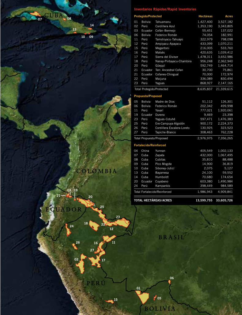
Inventarios Rápidos/Rapid Inventories
Protegido/Protected Hectáreas Acres
01 Bolivia Tahuamanu 1,427,400 3,527,18202 Perú Cordillera Azul 1,353,190 3,343,80503 Ecuador Cofán-Bermejo 55,451 137,02206 Bolivia Federico Román 74,054 182,99111 Perú Tamshiyacu-Tahuayo 322,979 798,09812 Perú Ampiyacu-Apayacu 433,099 1,070,21115 Perú Megantoni 216,005 533,76016 Perú Matsés 420,635 1,039,41217 Perú Sierra del Divisor 1,478,311 3,652,98618 Perú Nanay-Pintayacu-Chambira 956,248 2,362,94020 Perú Güeppí 592,749 1,464,71421 Ecuador Terr. Ancestral Cofan 30,700 75,86121 Ecuador Cofanes-Chingual 70,000 172,97422 Perú Maijuna 336,089 830,49423 Perú Yaguas 868,927 2,147,165
Total Protegido/Protected 8,635,837 21,339,615
Propuesto/Proposed
05 Bolivia Madre de Dios 51,112 126,30106 Bolivia Federico Román 202,342 499,99811 Perú Yavarí 777,021 1,920,06119 Ecuador Dureno 9,469 23,39823 Perú Yaguas-Cotuhé 597,471 1,476,38325 Perú Ere-Campuya-Algodón 900,172 2,224,37326 Perú Cordillera Escalera-Loreto 130,925 323,52327 Perú Tapiche-Blanco 308,463 762,228
Total Propuesto/Proposed 2,976,975 7,356,265
Fortalecido/Reinforced
04 China Yunnan 405,549 1,002,13307 Cuba Zapata 432,000 1,067,49508 Cuba Cubitas 35,810 88,48809 Cuba Pico Mogote 14,900 36,81910 Cuba Siboney-Juticí 2,075 5,12713 Cuba Bayamesa 24,100 59,55214 Cuba Humboldt 70,680 174,65420 Ecuador Cuyabeno 603,380 1,490,98424 Perú Kampankis 398,449 984,589
Total Fortalecido/Reinforced 1,986,943 4,909,841
TOTAL HECTÁREAS/ACRES 13,599,755 33,605,726
Instituciones participantes/ Participating Institutions
The Field Museum
Centro para el Desarrollo del Indígena Amazónico (CEDIA)
Instituto de Investigaciones de la Amazonía Peruana (IIAP)
Servicio Nacional de Áreas Naturales Protegidas por el Estado (SERNANP)
Servicio Nacional Forestal y de Fauna Silvestre (SERFOR)
Herbario Amazonense de la Universidad Nacional de la Amazonía Peruana (AMAZ)
Museo de Historia Natural de la Universidad Nacional Mayor de San Marcos
Centro de Ornitología y Biodiversidad (CORBIDI)
Esta publicación ha sido financiada en parte por The Gordon and
Betty Moore Foundation y The Field Museum./This publication has
been funded in part by The Gordon and Betty Moore Foundation
and The Field Museum.
The Field Museum Science and Education1400 South Lake Shore DriveChicago, Illinois 60605-2496, USA T 312.665.7430 F 312.665.7433
www.fieldmuseum.org/rbi
Perú: Tapiche-B
lanco R
apid Biological and Social Inventories
TH
E F
IELD
MU
SE
UM
27 Perú: Tapiche-Blanco
27no.
....................................................................................................................................................................................................................................................................................................................................................................................................................................................................................................................
....................................................................................................................................................................................................................................................................................................................................................................................................................................................................................................................


