Download - Nine Mile Canyon Scoping Document - Utah
United States Department of the Interior
Bureau of Land Management
Nine Mile Canyon
Special Recreation Management Area
Recreation Area Management Plan
Scoping Document
August 26, 2014
Price Field Office
125 South 600 West
Price, Utah 84501
(435) 636-3600
Nine Mile Canyon Scoping Document
August 26, 2014
2
Nine Mile Canyon Special Recreation Management Area
Recreation Area Management Plan
Scoping Document
TABLE OF CONTENTS
Purpose & Need
Section1.1 Introduction 3
Section1.2 Location & Setting 3
Section1.3 Purpose and Need 4
Section1.4 Objectives 4
Section1.5 Decision to Be Made 6
Maps
Map 1 Planning Area 7
Map 2 Nine Mile Canyon ROS Classes 8
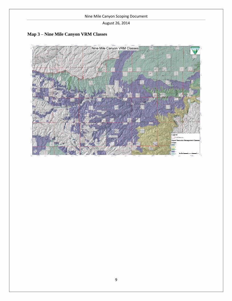
Map 3 Nine Mile Canyon VRM Classes 9
Appendices
Appendix 1 Applicable Authorities 10
Appendix 2 Resource Management Plan Decisions 11
Appendix 3 Process Flowchart 22
Nine Mile Canyon Scoping Document
August 26, 2014
3
Scoping Document
Purpose and Objective
1.1 Introduction
This scoping document solicits public comments to inform the development of an activity-level
Recreation Area Management Plan and Environmental Assessment. The plan will implement
decisions made in the Bureau of Land Management’s (BLM) Vernal and Price Field Offices’
Resource Management Plans (RMPs, 2008) and actions prescribed by the West Tavaputs
Programmatic Agreement (PA, 2010) in the Nine Mile Canyon (NMC) area.
1.2 Location and Setting
The Nine Mile Canyon area is rich in culture, wildlife and scenic beauty. The internationally-
renowned prehistoric sites within the canyon have been called “the longest art gallery in the
world,” while the historic features of the canyon have regional significance. Visitors enjoy
viewing wildlife along with the attractive cliffs and rugged scenery of the West Tavaputs Plateau
in east-central Utah.
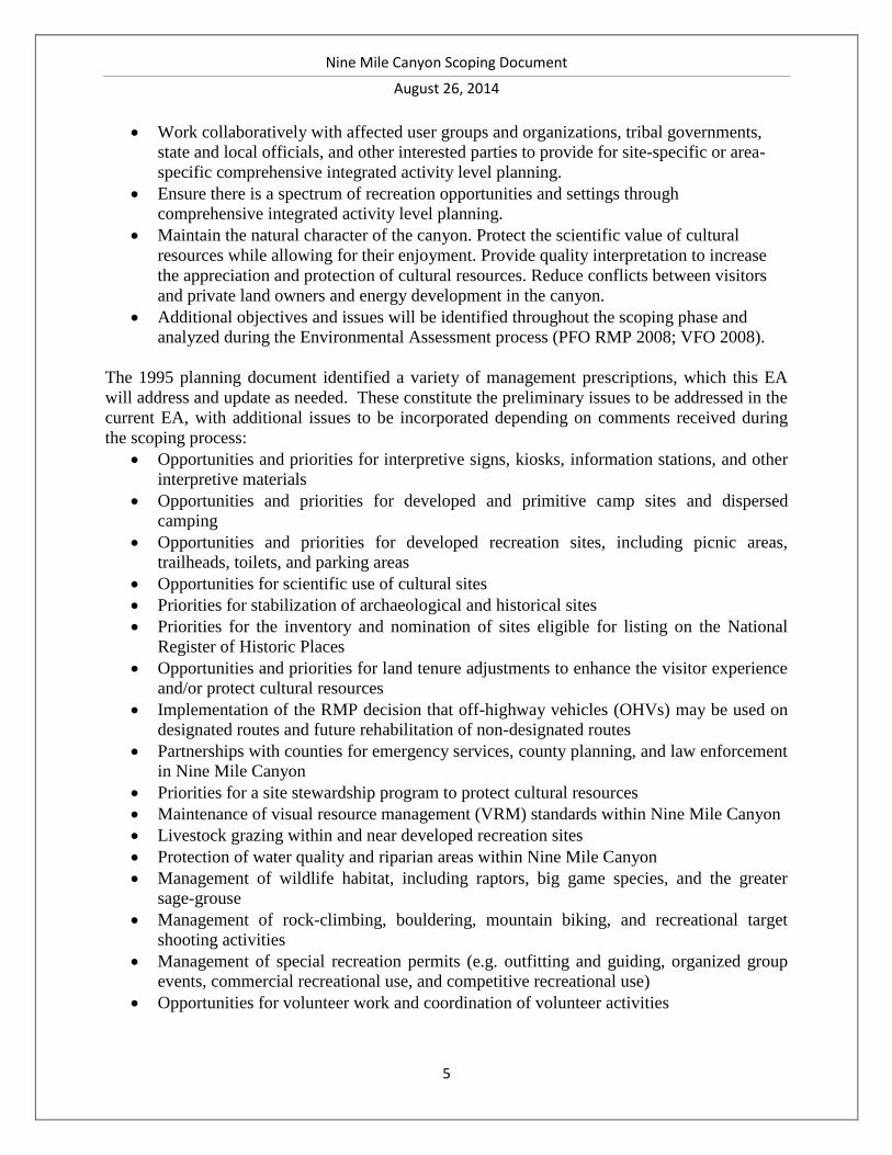
The planning area (Map 1) comprises the Nine Mile Canyon Special Recreation Management
Area (SRMA), as defined in the 2008 Price and Vernal RMPs. The Nine Mile Canyon SRMA
encompasses a total of 68,468 acres, managed by the BLM’s Price and Vernal Field Offices, and
is located in Carbon, Duchesne, and Uintah Counties (Table 1). Much of the planning area (and
the entire Vernal Field Office portion of the planning area) also falls within the Nine Mile
Canyon Area of Critical Environmental Concern. The planning area includes portions of the 78-
mile Nine Mile Canyon National Backcountry Byway.
Several of these designations overlap one another and may encompass lands beyond the NMC
SRMA designated boundaries (PFO RMP 2008; VFO RMP 2008). While some designations
share similar characteristics and management direction, others do not. Appendix 2 provides a
description of each designation, their associated management direction and their role in the
development of an updated NMC SRMA plan.
The planning area lies at an elevation between approximately 4,600 and 8,200 feet in the rugged
canyon country of the West Tavaputs Plateau. Draining the West Tavaputs Plateau, upper
tributaries start at 10,000 feet, and then reach Nine Mile Creek which flows from west to east
into the Green River, reaching the Green at 4,614 feet. Two major tributaries flow into Nine
Mile Creek from the northwest--Minnie Maud and Argyle Creeks. Smaller ephemeral streams,
such as Cottonwood and Dry Canyon Creeks, drain into it from the Tavaputs Plateau to the
south.
This scoping document establishes the framework for identifying alternative management
directions for implementation actions in the NMC area within the Vernal and Price field offices
SRMA boundaries.
Nine Mile Canyon Scoping Document
August 26, 2014
4
TABLE 1 – Land Administration
Land Administration Number of Acres
Price Field Office
Number of Acres
Vernal Field Office
Special Recreation
Management Area (SRMA) 24,300 44,168
Area of Critical
Environmental Concern
(ACEC)
26,200 44,168
1.3 Purpose and Need
The purpose of the EA is to provide guidance for the future management of the NMC area
consistent with the 2008 Price RMP, 2008Vernal RMP, and 2010 West Tavaputs PA. The focus
of this plan is on the management of visitor-based recreation and the preservation and
interpretation of cultural resources located in NMC. The plan will define visitor and resource
management objectives consistent with land use plans and will describe actions needed to
achieve these objectives.
As identified by existing planning documents (Nine Mile Canyon Special Recreation and
Cultural Management Area Plan 1995; Scenic Byway N.D.; PFO RMP 2008; VFO RMP 2008;
West Tavaputs Programmatic Agreement 2010), Nine Mile Canyon has abundant cultural and
recreational values. The increased use and paving of the road through Nine Mile Canyon have
made cultural sites in the area accessible to more vehicles, leading to concerns about
management of cultural and recreational resources. To move forward, this planning effort will
identify and resolve resource issues while considering the input of interested parties.
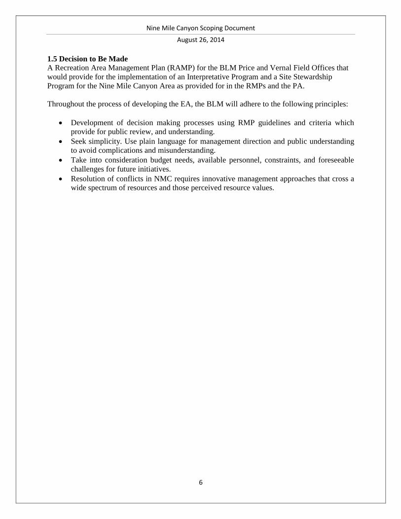
1.4 Objectives
The management principles for the SRMAs and ACECs identified within the Price and Vernal
RMPs are summarized in Appendix 2. The SRMAs as established in the Price and Vernal RMPs
can be further divided according to Recreation Management Zones and identified for specific
types of recreation according to the Recreation Opportunity Spectrum (Map 2) and for visual
resource classes (Map 3).
In 2010, BLM agreed to additional management prescriptions as a result of the West Tavaputs
Programmatic Agreement (PA), including the updating of the BLM’s 1995 Recreation and
Cultural Area Management Plan for Nine Mile Canyon. This EA is intended to meet the need
for an implementation-level decision consistent with the objectives identified in the RMPs. The
agency’s objectives for management of the area as outlined in the RMPs are:
Ensure the continued availability of quality outdoor recreation opportunities and
experiences that are not readily available from other sources; protect the health and safety
of visitors; protect natural, cultural, and other resources; encourage public enjoyment of
public lands; and enhance recreational opportunities.
Nine Mile Canyon Scoping Document
August 26, 2014
5
Work collaboratively with affected user groups and organizations, tribal governments,
state and local officials, and other interested parties to provide for site-specific or area-
specific comprehensive integrated activity level planning.
Ensure there is a spectrum of recreation opportunities and settings through
comprehensive integrated activity level planning.
Maintain the natural character of the canyon. Protect the scientific value of cultural
resources while allowing for their enjoyment. Provide quality interpretation to increase
the appreciation and protection of cultural resources. Reduce conflicts between visitors
and private land owners and energy development in the canyon.
Additional objectives and issues will be identified throughout the scoping phase and
analyzed during the Environmental Assessment process (PFO RMP 2008; VFO 2008).
The 1995 planning document identified a variety of management prescriptions, which this EA
will address and update as needed. These constitute the preliminary issues to be addressed in the
current EA, with additional issues to be incorporated depending on comments received during
the scoping process:
Opportunities and priorities for interpretive signs, kiosks, information stations, and other
interpretive materials
Opportunities and priorities for developed and primitive camp sites and dispersed
camping
Opportunities and priorities for developed recreation sites, including picnic areas,
trailheads, toilets, and parking areas
Opportunities for scientific use of cultural sites
Priorities for stabilization of archaeological and historical sites
Priorities for the inventory and nomination of sites eligible for listing on the National
Register of Historic Places
Opportunities and priorities for land tenure adjustments to enhance the visitor experience
and/or protect cultural resources
Implementation of the RMP decision that off-highway vehicles (OHVs) may be used on
designated routes and future rehabilitation of non-designated routes
Partnerships with counties for emergency services, county planning, and law enforcement
in Nine Mile Canyon
Priorities for a site stewardship program to protect cultural resources
Maintenance of visual resource management (VRM) standards within Nine Mile Canyon
Livestock grazing within and near developed recreation sites
Protection of water quality and riparian areas within Nine Mile Canyon
Management of wildlife habitat, including raptors, big game species, and the greater
sage-grouse
Management of rock-climbing, bouldering, mountain biking, and recreational target
shooting activities
Management of special recreation permits (e.g. outfitting and guiding, organized group
events, commercial recreational use, and competitive recreational use)
Opportunities for volunteer work and coordination of volunteer activities
Nine Mile Canyon Scoping Document
August 26, 2014
6
1.5 Decision to Be Made
A Recreation Area Management Plan (RAMP) for the BLM Price and Vernal Field Offices that
would provide for the implementation of an Interpretative Program and a Site Stewardship
Program for the Nine Mile Canyon Area as provided for in the RMPs and the PA.
Throughout the process of developing the EA, the BLM will adhere to the following principles:
Development of decision making processes using RMP guidelines and criteria which
provide for public review, and understanding.
Seek simplicity. Use plain language for management direction and public understanding
to avoid complications and misunderstanding.
Take into consideration budget needs, available personnel, constraints, and foreseeable
challenges for future initiatives.
Resolution of conflicts in NMC requires innovative management approaches that cross a
wide spectrum of resources and those perceived resource values.
Nine Mile Canyon Scoping Document
August 26, 2014
7
Maps
Map 1 – Planning Area
Nine Mile Canyon Scoping Document
August 26, 2014
8
Map 2 – Nine Mile Canyon ROS Classes
Nine Mile Canyon Scoping Document
August 26, 2014
9
Map 3 – Nine Mile Canyon VRM Classes
Nine Mile Canyon Scoping Document
August 26, 2014
10
Appendix 1 – Applicable Authorities
Laws and Mandates Guiding the Management of Nine Mile Canyon SRMA
The following laws, policies, and regulations guide management on the NMC SRMA:
Federal Land Policy and Management Act (FLPMA) of 1976 – Public Law 94-579, gives the
BLM legal authority to establish public land policy, to establish guidelines for administering
such policy and to provide for the management, protection, development, and enhancement of
the public land.
National Environmental Policy Act (NEPA) of 1969 – The NEPA requires that all Federal
agencies conduct detailed planning in full consultation with the public on any action that may
significantly affect the quality of the human and natural environment.
National Historical Preservation Act (NHPA) of 1966 – The NHPA requires all Federal agencies
to administer federally owned, administered, or controlled prehistoric and historic resources in a
spirit of stewardship for the inspiration and benefit of present and future generations. 36 CFR
800 and Section 106, in particular, stipulates that prior to the expenditure of any Federal funds on
any project, the agency must take into account the effect of the undertaking on any historic
properties.
Archaeological Resources Protection Act (ARPA) of 1979 – The ARPA provides protection for
archaeological resources on public lands by prohibiting the "excavation, removal, damage or
defacing of any archaeological resource located on public lands or Indian lands,” and set up
criminal penalties for these acts. It also encourages increased cooperation and exchange of
information between governmental authorities, the professional archaeological community, and
private individuals having archaeological resources and data which were obtained before
October 31, 1979.
In addition to these rules, the SRMA will include all applicable Federal laws, regulations,
executive orders, and policies. The additional laws, which will define BLM’s responsibilities
when analyzing environmental impacts, may include:
• American Indian Religious Freedom Act of 1978, 42 U.S.C. 1996
• Clean Air Act, as amended, 42 U.S.C. 7401 et seq.
• Clean Water Act of 1977, 33 U.S.C. 1251, et seq.
• Clean Water Act of 1987
• Comprehensive Environmental Response, Compensation and Liability Act of 1980,
as amended, 42 U.S.C. 9615
• Endangered Species Act of 1973, as amended, 16 U.S.C. 1531, et seq.
• Executive Order 11988, as amended, Floodplain Management, May 24, 1977
• Executive Order 11990, Protection of Wetlands, May 24, 1977
• Executive Order 12088, Federal Compliance with Pollution Control Standards
(Amended by Executive Order 12580 Superfund Implementation), October 13, 1978,
February 23, 1987
• BLM Manual 1601 – Land Use Planning
• BLM Manual 8100 – The Foundation for Managing Cultural Resources
Nine Mile Canyon Scoping Document
August 26, 2014
11
• BLM Manual 8110 – Identifying and Evaluating Cultural Resources
• BLM Manual 8120 – Tribal Consultation Under Cultural Resources
• BLM Manual 8130 – Planning for Uses of Cultural Resources
• BLM Manual 8140 – Protecting Cultural Resources
• BLM Manual 8150 – Permitting Uses of Cultural Resources
• BLM Manual 8170 – Interpreting Cultural Resources for the Public
• BLM Manual 8320 – Planning for Recreation and Visitor Services
Price Field Office Record of Decision Approved Management Plan (2008) – The PFO RMP will
provide guidance for the management of about 2,500,000 acres of Federal surface estate and
2,800,000 acres of Federal mineral estate administrated by the Bureau of Land Management
(BLM) in Carbon and Emery Counties in central-eastern Utah.
Vernal Field Office Record of Decision Approved Management Plan (2008) – The VFO RMP
will provide guidance for the management of over 1.7 million acres of public land and 3.9
million acres of Federal mineral estate administered by the Bureau of Land Management (BLM)
in Daggett, Duchesne, Uintah, and a small portion of Grand Counties in Northeast Utah.
Appendix 2 – Resource Management Plan Decisions
Price Field Office Resource Management Plan Vernal Field Office Resource Management
Plan
Total Acres: The BLM PFO management area Total Acres: The BLM VFO management area
Management Decisions as defined by RMP
CULTURAL RESOURCES (CUL)
Goals and Objectives:
Preserve and protect significant cultural
resources and ensure that they are
available for appropriate uses by
present and future generations (FLPMA
Sections 103(c), 201(a), and 202(c);
National Historic Preservation Act
[NHPA] Section 110(a);
Archaeological Resource Protection
Act [ARPA] Section 14(a)).
Identify priority geographic areas for
new field inventory, based on a
probability for unrecorded significant
resources, to reduce imminent threats
from natural or human-caused
deterioration or potential conflict with
other resource uses (ARPA Section
14(a); NHPA
Sections 106 and 110).
Cultural resources will be allocated to the
CULTURAL RESOURCES (CUL)
Goals and Objectives:
• Preserve and protect a representative array of
significant cultural resources, including but not
limited to traditional cultural properties,
traditional use areas, rock art, and ceremonial
sites, and ensure that they are available for
appropriate uses by present and future
generations.
• Preserve and protect cultural resources in
accordance with existing laws, regulations, and
Executive Orders (EO), in consultation with
designated contacts from Native American
tribes and the State Historic Preservation
Office (SHPO) to ensure that they are available
for appropriate uses by present and future
generations.
• Preserve and conserve cultural resources by
conducting activities in a way that protect
values and provide for the following benefits:
Conservation for future use
Nine Mile Canyon Scoping Document
August 26, 2014
12
following use categories identified and
described in BLM-M-8110.4:
Scientific Use
Public Use
Conservation for Future Use
Traditional Use
Experimental Use
Discharged from Management.
Management Decisions
CUL-1
Complete an appropriate cultural resources
inventory before approving permitted federal
undertakings that could affect cultural
resources or historic properties.
CUL-2
Mitigate adverse impacts on cultural resources
eligible for listing on the NRHP resulting from
authorized federal undertakings (permitted
activities, recreational use, OHV use, etc.) that
could affect cultural resources or historic
properties.
CUL-3
Manage cultural resources according to the
management objectives for the use category to
which each cultural resource site is assigned.
CUL-4
Cultural resources will be allocated according
to the following use categories identified and
described in BLM-M-8110.4:
Scientific Use
Public Use
Conservation for Future Use
Traditional Use
Experimental Use
Discharged from Management.
CUL-5
Allocations to the use categories will be made
during implementation and activity level
planning.
CUL-6
Cultural resource use allocations will be
reevaluated and revised, as needed, when
circumstances change or when new data
become available.
CUL-7
Education
Interpretation
Public use
Research
Management Decisions
CUL-1
Protect burial sites, associated burial goods,
and sacred items in accordance with the Native
American Graves Protection and Repatriation
Act (NAGPRA) and the Archaeological
Resources
Protection Act (ARPA).
CUL-2
Evaluate cultural resources according to
National Register criteria (36 CFR Part 60.4)
and assign cultural resources to appropriate use
categories as the basis for management
decisions.
CUL-3
Encourage public/volunteer involvement in the
management of cultural resources by
establishing site stewardship and other
programs.
CUL-4
Specific plans will be developed for culturally
sensitive areas unless included in other
integrated activity plans. Such plans will
include protective measures, Native American
consultation, and regulatory compliance. These
plans will also include but not be limited to:
• Developing a site monitoring system
• Identifying sites in need of stabilization,
restoration, and protective measures (e.g.,
fences, surveillance equipment)
• Developing research designs for selected
sites/areas
• Designating sites/areas for interpretive
development
• Identifying areas for cultural inventory where
federal undertakings are expected to occur
• Developing specific mitigation measures
The plan will designate sites, districts,
landmarks, and landscapes that will be
nominated for inclusion on the National
Register of Historic Places (NRHP).
Nine Mile Canyon Scoping Document
August 26, 2014
13
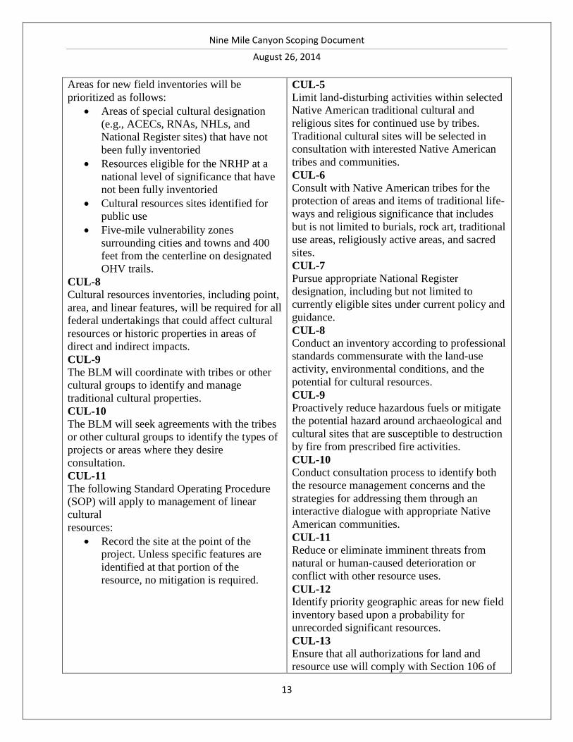
Areas for new field inventories will be
prioritized as follows:
Areas of special cultural designation
(e.g., ACECs, RNAs, NHLs, and
National Register sites) that have not
been fully inventoried
Resources eligible for the NRHP at a
national level of significance that have
not been fully inventoried
Cultural resources sites identified for
public use
Five-mile vulnerability zones
surrounding cities and towns and 400
feet from the centerline on designated
OHV trails.
CUL-8
Cultural resources inventories, including point,
area, and linear features, will be required for all
federal undertakings that could affect cultural
resources or historic properties in areas of
direct and indirect impacts.
CUL-9
The BLM will coordinate with tribes or other
cultural groups to identify and manage
traditional cultural properties.
CUL-10
The BLM will seek agreements with the tribes
or other cultural groups to identify the types of
projects or areas where they desire
consultation.
CUL-11
The following Standard Operating Procedure
(SOP) will apply to management of linear
cultural
resources:
Record the site at the point of the
project. Unless specific features are
identified at that portion of the
resource, no mitigation is required.
CUL-5
Limit land-disturbing activities within selected
Native American traditional cultural and
religious sites for continued use by tribes.
Traditional cultural sites will be selected in
consultation with interested Native American
tribes and communities.
CUL-6
Consult with Native American tribes for the
protection of areas and items of traditional life-
ways and religious significance that includes
but is not limited to burials, rock art, traditional
use areas, religiously active areas, and sacred
sites.
CUL-7
Pursue appropriate National Register
designation, including but not limited to
currently eligible sites under current policy and
guidance.
CUL-8
Conduct an inventory according to professional
standards commensurate with the land-use
activity, environmental conditions, and the
potential for cultural resources.
CUL-9
Proactively reduce hazardous fuels or mitigate
the potential hazard around archaeological and
cultural sites that are susceptible to destruction
by fire from prescribed fire activities.
CUL-10
Conduct consultation process to identify both
the resource management concerns and the
strategies for addressing them through an
interactive dialogue with appropriate Native
American communities.
CUL-11
Reduce or eliminate imminent threats from
natural or human-caused deterioration or
conflict with other resource uses.
CUL-12
Identify priority geographic areas for new field
inventory based upon a probability for
unrecorded significant resources.
CUL-13
Ensure that all authorizations for land and
resource use will comply with Section 106 of
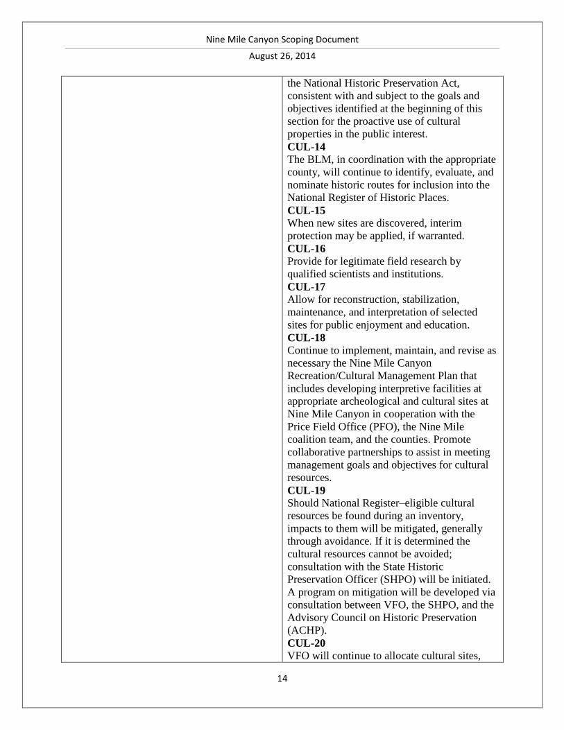
Nine Mile Canyon Scoping Document
August 26, 2014
14
the National Historic Preservation Act,
consistent with and subject to the goals and
objectives identified at the beginning of this
section for the proactive use of cultural
properties in the public interest.
CUL-14
The BLM, in coordination with the appropriate
county, will continue to identify, evaluate, and
nominate historic routes for inclusion into the
National Register of Historic Places.
CUL-15
When new sites are discovered, interim
protection may be applied, if warranted.
CUL-16
Provide for legitimate field research by
qualified scientists and institutions.
CUL-17
Allow for reconstruction, stabilization,
maintenance, and interpretation of selected
sites for public enjoyment and education.
CUL-18
Continue to implement, maintain, and revise as
necessary the Nine Mile Canyon
Recreation/Cultural Management Plan that
includes developing interpretive facilities at
appropriate archeological and cultural sites at
Nine Mile Canyon in cooperation with the
Price Field Office (PFO), the Nine Mile
coalition team, and the counties. Promote
collaborative partnerships to assist in meeting
management goals and objectives for cultural
resources.
CUL-19
Should National Register–eligible cultural
resources be found during an inventory,
impacts to them will be mitigated, generally
through avoidance. If it is determined the
cultural resources cannot be avoided;
consultation with the State Historic
Preservation Officer (SHPO) will be initiated.
A program on mitigation will be developed via
consultation between VFO, the SHPO, and the
Advisory Council on Historic Preservation
(ACHP).
CUL-20
VFO will continue to allocate cultural sites,
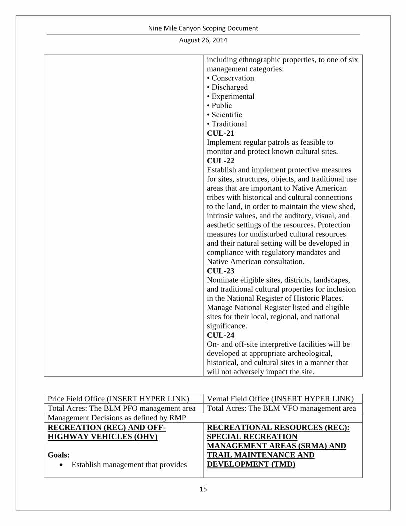
Nine Mile Canyon Scoping Document
August 26, 2014
15
including ethnographic properties, to one of six
management categories:
• Conservation
• Discharged
• Experimental
• Public
• Scientific
• Traditional
CUL-21
Implement regular patrols as feasible to
monitor and protect known cultural sites.
CUL-22
Establish and implement protective measures
for sites, structures, objects, and traditional use
areas that are important to Native American
tribes with historical and cultural connections
to the land, in order to maintain the view shed,
intrinsic values, and the auditory, visual, and
aesthetic settings of the resources. Protection
measures for undisturbed cultural resources
and their natural setting will be developed in
compliance with regulatory mandates and
Native American consultation.
CUL-23
Nominate eligible sites, districts, landscapes,
and traditional cultural properties for inclusion
in the National Register of Historic Places.
Manage National Register listed and eligible
sites for their local, regional, and national
significance.
CUL-24
On- and off-site interpretive facilities will be
developed at appropriate archeological,
historical, and cultural sites in a manner that
will not adversely impact the site.
Price Field Office (INSERT HYPER LINK) Vernal Field Office (INSERT HYPER LINK)
Total Acres: The BLM PFO management area Total Acres: The BLM VFO management area
Management Decisions as defined by RMP
RECREATION (REC) AND OFF-
HIGHWAY VEHICLES (OHV)
Goals:
Establish management that provides
RECREATIONAL RESOURCES (REC):
SPECIAL RECREATION
MANAGEMENT AREAS (SRMA) AND
TRAIL MAINTENANCE AND
DEVELOPMENT (TMD)
Nine Mile Canyon Scoping Document
August 26, 2014
16
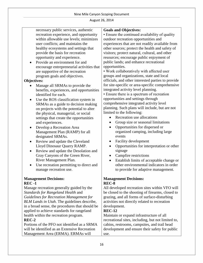
necessary public services, authentic
recreation experience, and opportunity
within allowable use levels; minimizes
user conflicts; and maintains the
healthy ecosystems and settings that
provide the basis for recreation
opportunity and experience.
Provide an environment for and
encourage entrepreneurial activities that
are supportive of the recreation
program goals and objectives.
Objectives:
Manage all SRMAs to provide the
benefits, experiences, and opportunities
identified for each.
Use the ROS classification system in
SRMAs as a guide to decision making
on projects with the potential to alter
the physical, managerial, or social
settings that create the opportunities
and experiences.
Develop a Recreation Area
Management Plan (RAMP) for all
designated SRMAs.
Review and update the Cleveland
Lloyd Dinosaur Quarry RAMP.
Review and update the Desolation and
Gray Canyons of the Green River,
River Management Plan.
Use recreation permitting to direct and
manage recreation use.
Management Decisions:
REC -1
Manage recreation generally guided by the
Standards for Rangeland Health and
Guidelines for Recreation Management for
BLM Lands in Utah. The guidelines describe,
in a broad sense, the procedures that should be
applied to achieve standards for rangeland
health within the recreation program.
REC-2
Portions of the PFO not identified as a SRMA
will be identified as an Extensive Recreation
Management Area (ERMA). ERMAs will
Goals and Objectives:
• Ensure the continued availability of quality
outdoor recreation opportunities and
experiences that are not readily available from
other sources; protect the health and safety of
visitors; protect natural, cultural, and other
resources; encourage public enjoyment of
public lands; and enhance recreational
opportunities.
• Work collaboratively with affected user
groups and organizations, state and local
officials, and other interested parties to provide
for site-specific or area-specific comprehensive
integrated activity level planning.
• Ensure there is a spectrum of recreation
opportunities and settings through
comprehensive integrated activity level
planning. Such plans will include, but are not
limited to the following:
Recreation use allocations
Group size or seasonal limitations
Opportunities for dispersed or
organized camping, including large
events
Facility development
Opportunities for interpretation or other
signage
Campfire restrictions
Establish limits of acceptable change or
other environmental indicators in order
to provide for adaptive management.
Management Decisions:
REC-8
All developed recreation sites within VFO will
be closed to the shooting of firearms, closed to
grazing, and all forms of surface-disturbing
activities not directly related to recreation
development.
REC-12
Maintain or expand infrastructure of all
recreational sites, including, but not limited to,
cabins, restrooms, campsites, and trail head
development and ensure their safety for public
use.
Nine Mile Canyon Scoping Document
August 26, 2014
17
receive only custodial management (which
addresses only activity opportunities) of visitor
health and safety, user conflict, and resource
protection issues with no activity-level
planning. Therefore, actions within ERMAs
will generally be implemented directly from
LUP decisions, such as Special Recreation
Permits (SRP) or OHV management decisions.
See Appendix R-9 for additional specific
recreation management objectives for the PFO
ERMA.
Recreation Activity Prescriptions and
Guidance:
REC-3
Allow dispersed camping throughout the PFO
without permit, unless otherwise designated by
the BLM. Determine and designate areas for
dispersed camping and associated access routes
with the cooperation of the counties.
REC-4
Prohibit rock climbing above or within 300
feet horizontally of cultural sites. Rock
climbing activities will be authorized only in
areas where there are no conflicts with cliff-
nesting raptors.
REC-5
Manage developed recreation sites as
recommended for withdrawal from mineral
entry or as open to oil and gas leasing subject
to major constraints (NSO).
REC-6
Close developed recreational sites to grazing
and include fencing the site in the development
plan when appropriate.
REC-7
Address non-motorized and motorized
recreational trails in activity level plans (e.g.,
designation and/or development of routes/trail
systems, maintenance, how the trails relate to
the ERMA,
SRMA, and specific RMZs, etc.).
REC-8
Allow mountain biking on all routes
designated for OHV use and on June’s Bottom
and Black Dragon Canyon routes and other
Special Recreation Management Areas
(SRMA)
SMRA-5
Nine Mile Canyon (44,168 acres) will continue
to be managed as an SRMA. An activity
management plan will be developed and
implemented consistent with overall
management objectives. In the recreation
portion of the plan, protection of high-value
cultural resources and scenic vistas will be
emphasized.
Trail Maintenance and Development (TMD)
TMD-6
Up to 400 miles of hiking, horseback riding,
and mechanized (non-motorized) trails will be
signed, improved, and/or developed in the
following areas:
• Bitter Creek
• Boulevard Ridge
• Burnt Timber Canyon
• Centennial Book Cliffs Trail
• Chipeta Canyon
• Daniels Canyon
• Devils Hole
• Green River
• Dry Fork
• Ely/Rainbow Park
• Home Mountain
• Little Mountain
• Nine Mile
• Rat Hole Canyon
• Spitzenberg/Warren Ridge
• Taylor Canyon
• Westwater Point
• Willow Creek
• Yellow Pine
• Other additional trails
Nine Mile Canyon Scoping Document
August 26, 2014
18
routes or areas designated for mountain bike
use. Designation of additional mountain bike
areas or routes will occur through activity
plans.
REC-9
Continue to manage and maintain developed
recreation sites. Sites administered by the PFO
are Daddy Canyon Recreation Site (RS), Price
Canyon RS, Cleveland-Lloyd Dinosaur
Quarry, Cedar Mountain RS, Buckhorn
Pictograph Panel, San Rafael Bridge RS,
Swaseys Cabin RS,
Little Wild Horse Canyon RS, Wedge
Overlook RS, and Temple Mountain RS. Sites
located in other field office areas and
maintained by the PFO are Lower Gray
Canyon RS, Mineral Bottom RS, and Sand
Wash RS.
REC-10
Develop new sites in response to user demand,
amenity value, and critical resource protection
needs.
Recreation Opportunity Spectrum (ROS):
REC-11
Within SRMAs, manage for Recreation
Opportunity Spectrum (ROS), as identified in
the ROS inventory (Map R-14). (See Appendix
R- 9 for description of ROS settings).
Recreation facilities will be developed only in
response to resource management needs and
will be appropriate to the managerial setting
identified for each ROS class.
Special Recreation Management Areas
(SRMAs) :
REC-12
Adjust RMZs identified in this RMP through
their respective SRMA activity plan, as
necessary.
REC-13
Designate all SRMAs as special areas (Federal
Lands Recreation Enhancement Act [2004]),
and if needed, require permits and payment of
fees for recreational use (Map R-14). Activity
plans will be created or updated for all
Nine Mile Canyon Scoping Document
August 26, 2014
19
SRMAs.
REC-14
Conduct all recreation management activities
and developments in the SRMA in support of
the individual SRMA goals and objectives.
Nine Mile Canyon SRMA:
REC-56
Specific recreation management direction for
the Nine Mile Canyon SRMA is contained in
Appendix R-9. This includes direction for the
following recreation management components:
Market Strategy; Market; Niche; Management
Goals; Management Objectives; Primary
Activities; Experiences; and Benefits.
REC-57
The Nine Mile Canyon SRMA will be
managed in coordination with the Vernal Field
Office according to the 1995 Recreation and
Cultural Area Management Plan except as
modified by the management alternatives listed
below. Such changes include VRM objectives.
REC-58
The Nine Mile Canyon SRMA will be created
as indicated on Map R-14 (24,300 Acres).
REC-59
The purpose of the Nine Mile Canyon SRMA
will be to manage recreation and interpretive
activities related to the cultural and historic
resources and landscapes in the area.
REC-60
Oil and gas will be open to leasing subject to
minor constraints (timing limitations,
controlled surface use, lease notices), except
where the Nine Mile Canyon ACEC overlaps
the SRMA. Where this overlap exists in the
SRMA, the area will be open to leasing with
major constraints
(NSO).
REC-61
Development will be required to meet VRM II
and III objectives (Map R-5).
REC-62
ROS class semi-primitive non-motorized areas
will be closed to OHV use. No facilities will be
located in these areas.
REC-63
Nine Mile Canyon Scoping Document
August 26, 2014
20
The remainder of the area will be limited to
designated routes, including all BLM and
county system roads.
REC-64
ROS roaded natural (RN) class areas will
contain visitor facilities, directional signage,
interpretive materials, and infrastructure to
support visitor health and safety, visitor
appreciation of cultural resources, and resource
protection.
REC-65
Private enterprise on private lands in support of
public visitation within RN class areas will be
encouraged by the BLM.
REC-66
The Nine Mile Canyon area will be closed to
camping on public lands except for designated
areas.
Special Recreation Permits:
REC-72
The BLM will issue SRP as a discretionary
action subject to NEPA analysis (Appendix R-
10). Additionally, commercial SRPs will also
be issued to provide a fair return for the
commercial use of public lands.
REC-73
SRPs will be issued according to established
evaluation factors described in Appendix R-10.
The factors identified will primarily examine
the sensitivity of the proposed site and the
nature of the proposed use.
REC-75
The BLM could require permits and/or charge
fees in all special areas
REC-76
Vending could be authorized in conjunction
with organized events or when the vending is
necessary to support resource protection or
appropriate recreation use. Vending permits
could also be authorized to enhance
recreational experience.
Price Vernal Field Office (INSERT HYPER LINK)
Total Acres: 26,200 Total Acres: 44,168
Nine Mile Canyon Scoping Document
August 26, 2014
21
Management Decisions as defined by RMP
NMC ACEC
Nine Mile Canyon—Relevant and
Important Values: Cultural:
ACEC-10
Rationale: This area holds significant
prehistoric archaeological resources. Nine Mile
Canyon is known to contain the country’s
highest concentration of rock art panels,
remnants of the prehistoric Archaic, Fremont,
and Ute cultures. About 80 percent of the
known sites are rock art.
This ACEC is within the BLM Vernal and
Price Field Offices.
Manage the area as an ACEC (26,200 acres).
Special management prescriptions will include:
Oil and gas will be open to leasing
subject to major constraints (NSO)
Split estate will be open to oil and gas
leasing subject to minor constraints
(CSU)
VRM Class II and III in selected areas
as indicated on Map R-5
Utility corridor will be allowed as
shown on Map R-21
In addition, the following general management
prescriptions will include:
Limit OHV use to designated routes
Open to disposal of mineral materials
Oil and gas development in the Nine
Mile Canyon ACEC will be permitted
after compliance with the NHPA
SPECIAL DESIGNATIONS: AREAS OF
CRITICAL ENVIRONMENTAL
CONCERN
(ACEC)
Goals and Objectives:
• Designate and manage areas as ACECs where
special management attention is required to
protect and prevent irreparable damage to
important historic, cultural, or scenic values;
fish and wildlife resources; or other natural
systems or processes, or to protect life and
safety from natural hazards.
ACEC-10
Nine Mile Canyon (44,168 acres) with a
boundary along the upper rim will continue to
be designated as an ACEC. The area will be
managed to enhance cultural and special status
plant species while enhancing scenic vistas,
recreation, and wildlife resource values. A
comprehensive integrated activity plan will be
developed and implemented. OHV use will be
limited to designated routes. Visual Resources
will be managed as Class II and Class III.
For oil and gas leasing within Nine Mile
Canyon:
• Approximately 26,797 acres will be open to
leasing subject to the terms and conditions of
the standard lease form.
• Approximately 209 acres will be open to
leasing subject to moderate constraints such as
TLs and CSU.
• Approximately 17,162 acres will be open to
leasing subject to major constraints such as
NSO stipulations.
• Zero acres will be unavailable for leasing.
Nine Mile Canyon Scoping Document
August 26, 2014
22
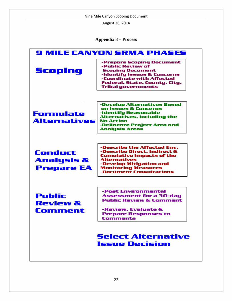
Appendix 3 – Process

Nine Mile Canyon Scoping Document
August 26, 2014
23


![WELCOME [ltempeis.anl.gov] · 2011. 11. 14. · Glen Canyon Dam Long-Term Experimental and Management Plan EIS Public Scoping Meeting Welcome to the Public Scoping Meetings for the](https://cdn.vdocuments.site/doc/165x107/60c22dba3c44363bef0df358/welcome-2011-11-14-glen-canyon-dam-long-term-experimental-and-management.jpg)