Download - May 3.2007 West Gulf River Forecast Center Rio Grande Hydrologic Services Expansion Meeting

May 3.2007West Gulf River Forecast Center
Rio Grande Hydrologic Services Rio Grande Hydrologic Services Expansion MeetingExpansion Meeting
Presentation OutlinePresentation Outline
Introduction to WGRFC
River Forecast Process
Rio Grande Forecast System
Challenges and Complications

The Function of WGRFCThe Function of WGRFC
To provide the most accurate and timely river stage forecasts… through a combination of our knowledge/skill of both meteorology and hydrology
This is accomplished through 2 main functions:– HAS (Hydrometeorological Analysis and Support)
Operations• 3 Forecasters
– Hydrologic Operations• 9 Forecasters

WGRFC StaffWGRFC Staff

WGRFC Hours of OperationWGRFC Hours of Operation
Normal Hours – 6:00 a.m. – 10:00 p.m.
Extension of hours– Event driven and/or in coordination with WFOs– “Close the Gap”
Overnight Shifts– 10:00 p.m. – 6:00 a.m.– Scheduled when prolonged rainfall/flooding event is expected

The WGRFC AreaThe WGRFC Area
WGRFC is one of 13 River Forecast Centers that provide
precipitation and river forecasts for the Continental U.S. and Alaska. WGRFC’s area of responsibility extends into
Mexico in order to cover tributary rivers that flow into the Rio
Grande.

Weather Forecast Offices (WFOs) Serving Weather Forecast Offices (WFOs) Serving the Rio Grande Drainagethe Rio Grande Drainage
River Forecast Center issues stage forecasts to area Weather Forecast
Office.
Weather Forecast Office adds location
specific impact statements and
disseminates
to the public.

Forecast ProcessForecast Process

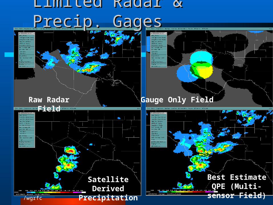
Big Bend Region - 07/28/04Big Bend Region - 07/28/04
Gauge Only FieldRaw Radar Field
Satellite Derived Precipitation
Best Estimate QPE (Multi-sensor Field)

Precipitation EstimatesPrecipitation Estimates

Averaged PrecipitationAveraged Precipitation


AHPS Web PageAHPS Web Page
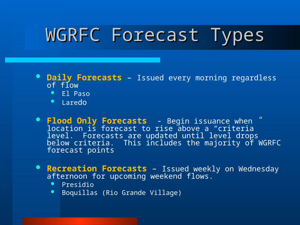
WGRFC Forecast TypesWGRFC Forecast Types
Daily Forecasts – Issued every morning regardless of flow El Paso Laredo
Flood Only Forecasts - Begin issuance when location is forecast to rise above a “criteria” level. Forecasts are updated until level drops below criteria. This includes the majority of WGRFC forecast points
Recreation Forecasts – Issued weekly on Wednesday afternoon for upcoming weekend flows. Presidio Boquillas (Rio Grande Village)

River Recreation ForecastRiver Recreation Forecast

Rio Grande Forecast SystemRio Grande Forecast System
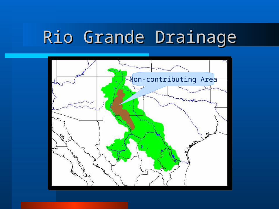
Rio Grande DrainageRio Grande Drainage
Non-contributing Area
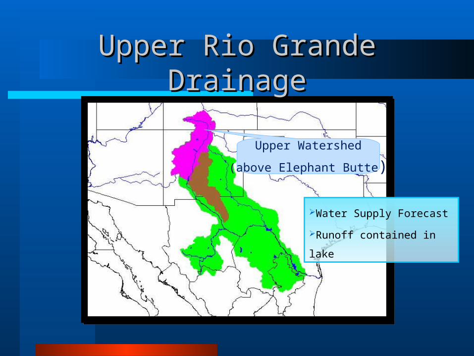
Upper Watershed
(above Elephant Butte)
Upper Rio Grande DrainageUpper Rio Grande Drainage
Water Supply Forecast
Runoff contained in lake
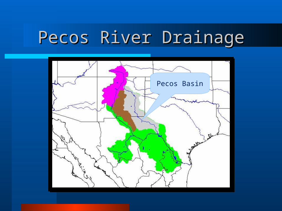
Pecos Basin
Pecos River DrainagePecos River Drainage

Rio Conchos Basin
(above Luis Leon)
Rio Conchos DrainageRio Conchos Drainage
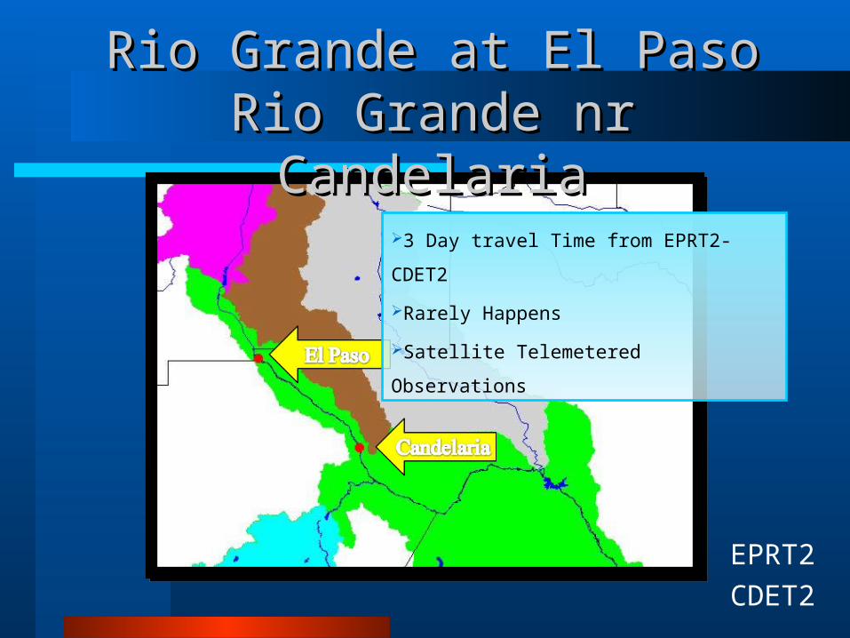
Rio Grande at El PasoRio Grande at El PasoRio Grande nr CandelariaRio Grande nr Candelaria
EPRT2
CDET2
3 Day travel Time from EPRT2-CDET2
Rarely Happens
Satellite Telemetered Observations

Rio Grande above Rio ConchosRio Grande above Rio Conchos Presidio Presidio
PIOT2
18 Hr travel Time from CDET2-PIOT2
Satellite Telemetered Observations
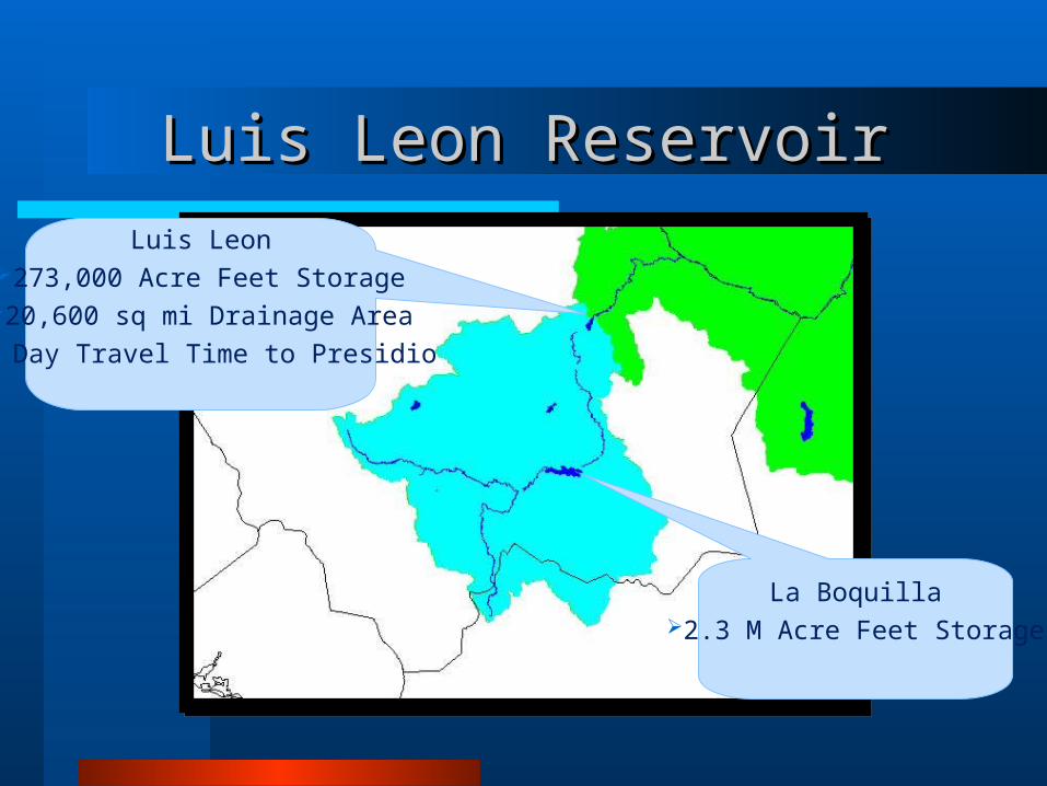
Luis Leon ReservoirLuis Leon Reservoir
La Boquilla2.3 M Acre Feet Storage
Luis Leon273,000 Acre Feet Storage
20,600 sq mi Drainage Area1 Day Travel Time to Presidio

Rio Grande below Rio ConchosRio Grande below Rio ConchosPresidio (International Bridge)Presidio (International Bridge)
Rio Conchos belowLuis Leon3414 sq mi12 hr CrestSatellite Telemetered Data
from Mexican Gage
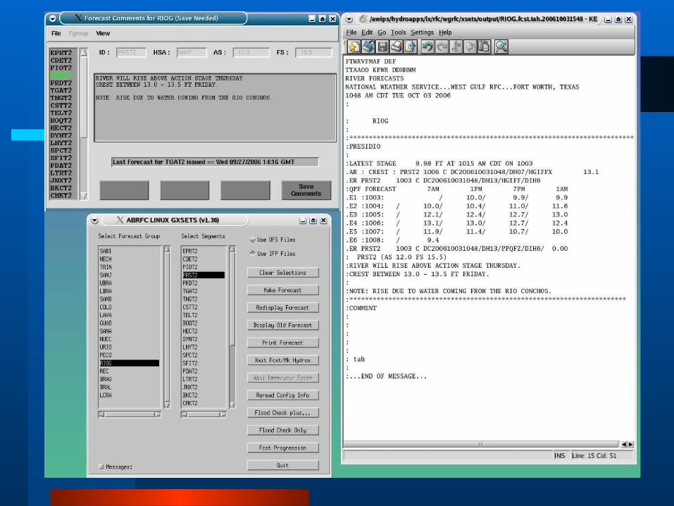
PRST2
Cibilo Creek269 sq mi6 hr CrestSatellite Telemetered Data

Rio Grande nr Presidio (Weir)Rio Grande nr Presidio (Weir)
PRDT2
Alamito Creek860 sq mi6 hr CrestSatellite Telemetered Data

Rio Grande nr LajitasRio Grande nr Lajitas
6-12 Hr travel Time from PRDT2
Daily Observations
TGAT2

Terlingua Creek nr TerlinguaTerlingua Creek nr Terlingua
TNGT2
Terlingua Creek784 sq mi12 hr CrestSatellite Telemetered Data

Rio Grande nr CastolonRio Grande nr Castolon
CSTT2
Observed Data on Request
Forecasts based on TELT2 hydrologic
parameters (high uncertainty)

Rio Grande at Johnson RanchRio Grande at Johnson Ranch
TELT2
6-12 Hour Travel Time from TGAT2
Satellite Telemetered Data

Rio Grande nr Boquillas Ranger Rio Grande nr Boquillas Ranger Station (Rio Grande Village)Station (Rio Grande Village)
BOQT2
6-12 Hr travel Time from CSTT2
Daily Observed Data

Rio Grande nr Heath CanyonRio Grande nr Heath Canyon
HECT2
6-12 Hr travel Time from BOQT2
No Observed Data

Rio Grande nr DrydenRio Grande nr Dryden
DYNT2
6-12 Hr travel Time from HECT2
Satellite Telemetered Data

Rio Grande at Foster RanchRio Grande at Foster Ranch
LNYT2
6-12 Hr travel Time from DYNT2
Satellite Telemetered Data

Challenges & ComplicationsChallenges & Complications
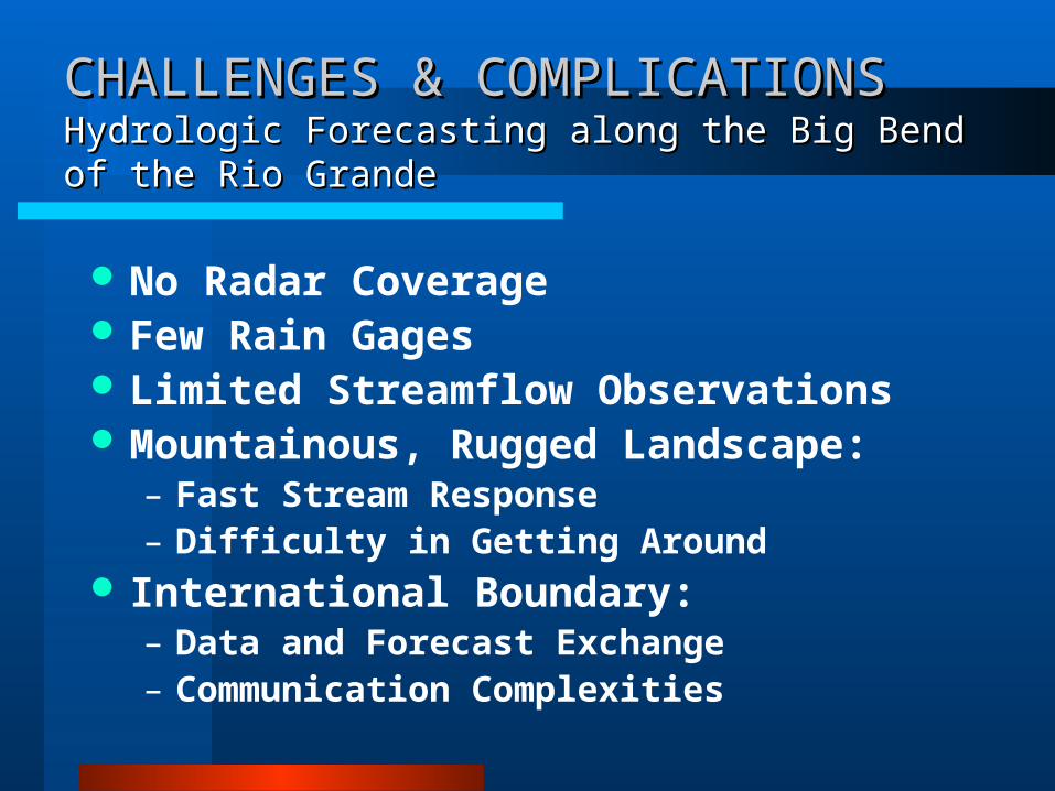
CHALLENGES & COMPLICATIONSCHALLENGES & COMPLICATIONSHydrologic Forecasting along the Big Bend of the Rio GrandeHydrologic Forecasting along the Big Bend of the Rio Grande
No Radar Coverage Few Rain Gages Limited Streamflow Observations Mountainous, Rugged Landscape:
– Fast Stream Response– Difficulty in Getting Around
International Boundary:– Data and Forecast Exchange– Communication Complexities

Radar Coverage MapRadar Coverage Map
http://www.srh.noaa.gov/wgrfc
Limited Radar & Precip. GagesLimited Radar & Precip. Gages
Gauge Only FieldRaw Radar Field
Satellite Derived Precipitation
Best Estimate QPE (Multi-sensor Field)


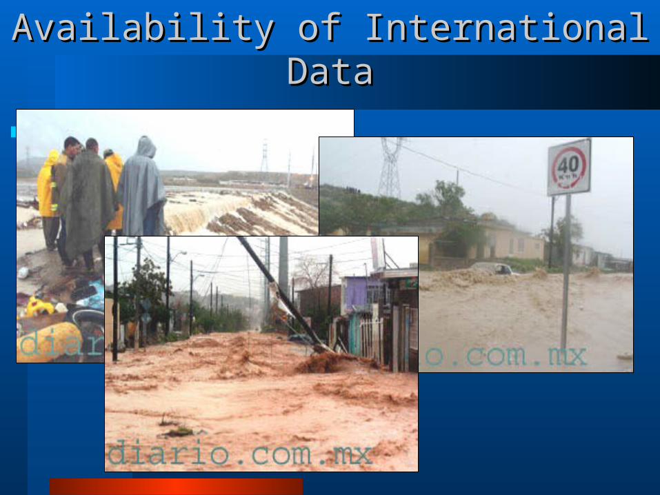
Availability of International DataAvailability of International Data

Please visit our website at:www.srh.weather.gov/wgrfc
For Additional Questions or Comments, Please contact us:817-831-3289 [email protected]@noaa.gov
Thank You for Your Time!Thank You for Your Time!


