Download - MAPWORK - dlsgeography.weebly.com

MAPWORK
TOPIC ONE

Why do we use maps? Maps are very important tools for geographers because they enable them to
record, display and analyse information about people and the environment
around them.
Maps can be in the form of paper, digital images and also globes.

Aerial photographs are of particular use to geographers and cartographers.
When taken from a relatively low altitude, they are also used to plan towns and
structures, accurately measure roads and rivers, survey the resources of an
area, and show how the physical and cultural features of a place have changed
over time.
Brief history of aerial photography
Since the late 1850’s, people have been trying to see the world as the birds do.
The first two attempts at aerial photography were actually by balloon! The first
was in 1858 when someone flew over Paris. Sadly, the pictures they took are no
longer around. But, in 1860, two men flew over and photographed Boston.
This photograph was called “Boston as the Eagle and the Wild Goose see it”!
Aerial Photograhy

Next, in 1882, a man named E.D. Archibald used a kite instead of a balloon to
take pictures. This proved useful for meteorologists, and others followed his ex-
ample. Still, even newer methods rapidly gained popularity. In 1909, a group of
people mounted a video camera to an airplane! They did it to make a short
movie .
And think about it, how many movies nowadays still do this?
Aerial view of Wall Street in NYC
Aerial photography after WW1
Aerial photography really took off after
World War 1. During the war, people would
use planes to scout enemy territory.
Afterward, air force veterans used these
same skills for more peaceful purposes.
They’d use planes to take and sell pictures,
as people still do today. Although, they’re
now also rivalled by satellite photographers!
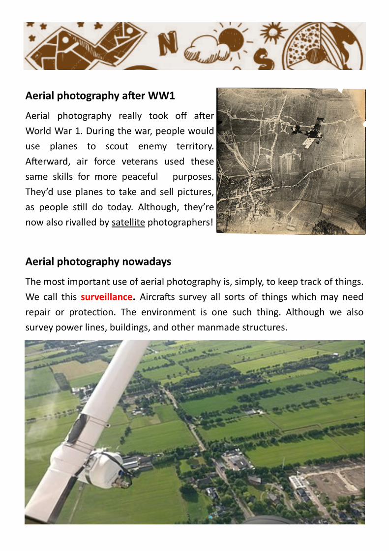
Aerial photography nowadays
The most important use of aerial photography is, simply, to keep track of things.
We call this surveillance. Aircrafts survey all sorts of things which may need
repair or protection. The environment is one such thing. Although we also
survey power lines, buildings, and other manmade structures.

Now it’s your turn. Try to guess these landmarks and discuss
your findings.
________________________________
________________________________

________________________________
________________________________

________________________________
________________________________

The lines extending around the Earth horizontally are called lines of latitude.
They measure how far north or south an object is on the Earth. The lines run-
ning vertically around the Earth are called longitude. These lines are also called
meridians, and measure how far east or west an object is.
Longitude & Latitude

As with latitude, longitude is measured as an angular distance. With latitude,
the angular distance is measured from the equator. This is a natural place to
begin.
However, with longitude there is no natural beginning point. One of these lines
must be designated as a prime meridian, or as the 0° mark, but which one?
Where is the official worldwide Prime Meridian?
________________________________

The further away from the Prime Meridian that one travels the higher their
longitude becomes, until they reach 180° longitude. If an individual is in the
Eastern Hemisphere, their longitude is measured in degrees east. If they are in
the Western Hemisphere, their longitude is measured in degrees west.

If you stay in one place, a day lasts 24
hours. However, if you travel the
opposite direction Earth’s rotation,
your day will be slightly longer than 24
hours, because you are traveling
ahead of the setting sun. If you travel
with the rotation of the Earth, your
day will be slightly shorter than 24
hours because you are traveling into
the sunset.
The International Date Line

At any one moment there are actually two days on the Earth at the same time.
A new day begins at midnight on the International Dateline. It travels around
the Earth until 48 hours later it ends back at the International dateline. If you
were to travel across the International Dateline, the date would change either
forward or backward. This line actually lies in the middle of a time zone. This
means that the hour on the clock would not change as you crossed over, just
the date.

A time zone is an area on Earth that has a specific time that all citizens can set
their clocks to.
Different places on Earth have different time zones. They exist because the
Earth is round and they allow everyone to have sunrise and sunset.
You can figure out if another time zone is earlier or later than yours just be
seeing if it is west or east of you on a map.
Timezones


Knowing the time zones is very important for communication. To be able to
identify and calculate time zones, you must know terms like Lines of
Longitude, Prime Meridian and the International Date Line.
What time it is at different places on earth depends on lines of longitude.
These are the imaginary lines that run from the North Pole to the South Pole.
If you slice the Earth evenly across, it would look like a circle.
A full circle is 360 degrees around. These degrees is how we can divide the
Earth into time zones.

The line of longitude labelled 0 deg is the prime meridian.
• Lines to the right of the prime meridian are labelled east;
for example, the line labelled 90 degs E.
• Lines to the left of the prime meridian are labelled west;
for example, the line labelled 90 degs W.
If you travel all the way around the earth in one direction, you would have
travelled 360 degs.
How does this relate to time?
When the earth rotates, we experience day (sunrise) and night (sunset). But
what's really happening is that our position on the earth is facing towards and
then away from the sun.
A full circle rotation of the earth on its axis towards and then away from the sun
equals one day, or 24 hours.
So if 24 hours = 360 degs, how many degs is 1 hour?
________________________________________________________________
This means that, as the earth rotates, it takes one hour for it to move ______
degs on its axis.
Time Zones explained...


Your friend who lives in Greenwich, England, plans to call at
8:15 pm your time to wish you happy birthday on Saturday.
Imagine that you live in New York City. What time and day will
it be in Greenwich when your friend telephones?
Solving the problem…
___________________________________________________
___________________________________________________
___________________________________________________
___________________________________________________
___________________________________________________
___________________________________________________
Practice problem


