Mapping the Noise and Vibration Nuisance
of the Proposed Baltimore-Washington
Superconducting Maglev Train
Citizens Against This SCMaglev (CATS)
January 2018
Facebook: https://www.facebook.com/groups/CitizensAgainstSCMaglev
Email: [email protected]
2
Contents
Part 1: Maps ............................................................................................................. 3
1. Citizens Against This SCMaglev (CATS) .............................................................................. 3
2. Motivation for the CATS Mapping Effort .............................................................................. 3
3. The CATS Geographic Information System........................................................................... 4
4. A Map of South Laurel, Maryland .......................................................................................... 4
5. A Map of Greenbelt, Maryland ............................................................................................... 7
6. A Map of Bladensburg, Maryland .......................................................................................... 9
Part 2: Nuisance Distance .....................................................................................11
1. Overview ............................................................................................................................... 11
2. Noise Nuisance ..................................................................................................................... 12
2.1. Initial screening for noise nuisance................................................................................ 12
2.2. General assessment of noise nuisance ........................................................................... 14
3. Ground-vibration Nuisance ................................................................................................... 15
4. Rapid-onset Nuisance ........................................................................................................... 16
5. Mathematical Details ............................................................................................................ 17
5.1. Mathematical details of noise nuisance ......................................................................... 17
5.2. Mathematical details of ground-vibration nuisance ....................................................... 19
5.3. Mathematical details of rapid-onset nuisance ................................................................ 21
5.4. Variation in maglev speed as a function of distance from the nearest station ............... 21
6. Comparison with Official Estimates ..................................................................................... 24
References ...............................................................................................................28
3
Part 1: Maps
1. Citizens Against This SCMaglev (CATS) Citizens Against This SCMaglev (CATS) is a grassroots organization concerned about the
proposed Superconducting Magnetic Levitation (SCMaglev) train project between Baltimore,
Maryland and Washington, DC. CATS feel strongly that the SCMaglev is not in the best interest
of Maryland residents, and we are working to raise awareness of the project and to highlight
serious impacts that the SCMaglev may have in many communities.
Approximately 3,000 people have participated in CATS since the group formed in 2017. Their
background, experience, and technical abilities allow CATS to address the proposed Baltimore-
Washington SCMaglev on a professional level. The CATS organizational structure provides the
resources for research, technical writing, technical analysis, and outreach. Contributors to this
paper include members of the Research and Geographic Information Systems (GIS) groups
within CATS.
2. Motivation for the CATS Mapping Effort
In October 2017, the SCMaglev environmental impact study announced three possible track
alignments for the 36-mile-long proposed rail line between Baltimore and Washington DC
(http://www.bwmaglev.info/).
It is difficult for the public and for elected officials to form opinions about the impacts of these
alternatives when they lack information about how far from the track a noise nuisance or a
ground-vibration nuisance may be generated by the passage of maglev trains. Maglev-generated
noise may disrupt sleep, ground vibration may rattle homes and places of business, and the rapid
onset of the maglev noise is a safety hazard because it can startle. All three of these kinds of
nuisance may hamper business activities, reduce residents' quality of life, and lower property
values along the track. The present document makes no attempt to evaluate if the proposed
SCMaglev is an efficient use of the funds available to address the region's transportation needs.
While the SCMaglev environmental impact study has yet to publish estimates of how far from
the proposed tracks the noise and vibration nuisances will extend, the Federal Railroad
Administration (FRA) has published methods that one can use to estimate such distances. These
methods were published in 2012 and can be downloaded from
https://www.fra.dot.gov/eLib/details/L04090. The intended audience of FRA (2012) is the
professional who is performing an environmental impact study, project sponsors, elected
officials, and interested citizens (page 1-1). Part I of the present document includes sample maps
generated using the methodology in FRA (2012). Part II of the present document explains how
these nuisance distances were obtained from FRA (2012).

4
The research described in FRA (2012) establishes that a maglev train travels fast enough to
generate considerable noise and ground vibration despite the train's aerodynamic shape. During
the day, the noise of a maglev train's passage may be particularly unwelcome in venues such as
schools, day-care centers, hospitals, doctor and dentist offices, libraries, houses of worship,
parks, monuments, or other places where a peaceful atmosphere is expected or concentration is
required. During the night, the noise of a maglev train's passage may disrupt sleep. Some
studies suggest that senior citizens may be particular susceptible to this effect whether sleeping
in a private resident or a senior-care facility. The ground vibration from a maglev train creates a
kind of "economic dead zone" near its track where certain kinds of research, manufacturing, and
medical activities are prohibited.
3. The CATS Geographic Information System For Maryland residents, elected officials, and the directly impacted populations to understand
and comment meaningfully on the impacts of the proposed SCMaglev rail line, the CATS-GIS
group has created maps that show an estimate of the noise or ground-vibration impact. The
group has also analyzed such impacts to specific properties along the proposed track alignments.
To generate maps and analyses, CATS has used a Geographic Information System (GIS). A GIS
is a combination of software, data, hardware, and technical experts who can perform mapping
and analysis functions. Specific to the proposed SCMaglev train routes, this GIS identifies the
populations, community facilities, and geographic areas impacted by the noise and vibrations of
the proposed SCMaglev trains. This analysis works from the proposed routes as stated on the
Maryland Department of Transportation's SCMaglev website (http://www.bwmaglev.info/).
Ancillary data sources are listed in the Reference section.
The geographic buffers created within the GIS are based on the Federal Railroad Administration
formulas that are specific to maglev technology, as described in Part II of the present document.
Once calculated, the geographic buffers are used to identify the property parcels that may be
impacted by means of a geographic “join” of the different layers.
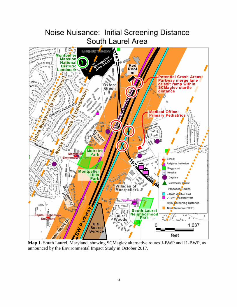
4. A Map of South Laurel, Maryland Map 1 shows how properties in South Laurel might be impacted by the SCMaglev. The map
highlights possible traffic-safety issues, economic impacts, and quality-of-life impacts along this
1.7 mile portion of the 36 miles between Baltimore and Washington.
There is reason to believe that the proposed SCMaglev line will cause automobile fatalities at
locations where the South Laurel map is marked with red circles near the Baltimore-Washington
Parkway. At these locations, drivers in merge lanes or exit ramps may be startled by the sudden
and unexpected sound of the maglev's passage, directly overhead, along its elevated track. At a
50-foot distance, a 300-mph maglev train has a 97 dBA equivalent sound level that rapidly goes
from quiet to maximum loudness in second or two. The maximum volume of the maglev sound

5
when 50 feet from the track is approximately twice as loud as that of a jackhammer, 50 feet
away. These volume estimates are discussed further in Section 5.1 of Part II. Section 4 of Part II
provides more information about the startle distance. One would imagine that the National Park
Service would be interested in reviewing these potential impacts, as the Baltimore-Washington
Parkway is a unit of the National Park Service.
In terms of economic impact, South Laurel businesses such as the hotel just north of the
Parkway/Route-197 interchange would likely suffer from complaints stemming either from the
maglev's airborne noise or from indoor noise that would be generated when maglev ground-
borne vibrations enter the building. The owners of such businesses would have to hope that their
buildings do not happen to have resonances at the maglev track's main vibration frequencies or
else the impact to building occupants would be greater. Such uncertainty could be removed
through geological and engineering field studies of the specific buildings and intervening soil.
CATS is not aware of such field work having been conducted as part of the SCMaglev
environmental impact study at this time.
The biggest quality-of-life issue for most people living or working near the maglev line in South
Laurel may be the noise nuisance generated by the passage of the trains. The number of homes
and other resources that one tags as subject to an airborne noise nuisance depends on the distance
from the track that one uses as a threshold. Plausible distances are 700 feet, 1,933 feet, or 3,074
feet, as discussed below. Map 1 shows these three distances with an orange area, a dashed
orange line, or a dotted orange line, respectively.
A 700-foot distance is the "initial screening" distance that the Federal Railroad Administration
(FRA) gives for a maglev train traveling at least 200 mph. (See Section 2 of Part II.) Among the
resources within 700 feet of maglev alternatives J-BWI or J1-BWI are two parks (i.e., Muirkirk
Park and Montpelier Hills Park), several residential neighborhoods (e.g., Apache Tears, Villages
of Montpelier, Montpelier Hills), and a U.S. Secret Service facility.
The SCMaglev train is likely to be traveling 300 mph through South Laurel, not merely 200
mph. (See Section 5.4 of Part II.) For this reason, 700 feet is likely to be an underestimate of the
geographic extent of the noise nuisance while 1,933 feet or 3,074 feet is likely to be a more
accurate estimate, depending on the number of maglev train passbys per hour. (See Section 3 of
Part II.) Resources that fall within the 3,074-foot buffer include the Montpelier Mansion
National Historic Landmark, Montpelier Elementary School, Capital Technology University,
South Laurel Neighborhood Park, several houses of worship, medical offices (i.e., Primary
Pediatrics), several child-care centers, and many residences.
6
Map 1. South Laurel, Maryland, showing SCMaglev alternative routes J-BWP and J1-BWP, as
announced by the Environmental Impact Study in October 2017.
7
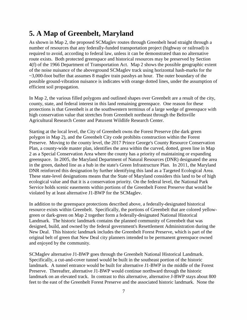
5. A Map of Greenbelt, Maryland As shown in Map 2, the proposed SCMaglev routes through Greenbelt head straight through a
number of resources that any federally-funded transportation project (highway or railroad) is
required to avoid, according to federal law, unless it can be demonstrated than no alternative
route exists. Both protected greenspace and historical resources may be preserved by Section
4(f) of the 1966 Department of Transportation Act. Map 2 shows the possible geographic extent
of the noise nuisance of the aboveground SCMaglev track using horizontal hash-marks for the
~3,000-foot buffer that assumes 8 maglev train passbys an hour. The outer boundary of the
possible ground-vibration nuisance is indicates with orange dotted lines, under the assumption of
efficient soil propagation.
In Map 2, the various filled polygons and outlined shapes over Greenbelt are a result of the city,
county, state, and federal interest in this land remaining greenspace. One reason for these
protections is that Greenbelt is at the southwestern terminus of a large wedge of greenspace with
high conservation value that stretches from Greenbelt northeast through the Beltsville
Agricultural Research Center and Patuxent Wildlife Research Center.
Starting at the local level, the City of Greenbelt owns the Forest Preserve (the dark green
polygon in Map 2), and the Greenbelt City code prohibits construction within the Forest
Preserve. Moving to the county level, the 2017 Prince George's County Resource Conservation
Plan, a county-wide master plan, identifies the area within the curved, dotted, green line in Map
2 as a Special Conservation Area where the county has a priority of maintaining or expanding
greenspace. In 2005, the Maryland Department of Natural Resources (DNR) designated the area
in the green, dashed line as a hub in the state's Green Infrastructure Plan. In 2011, the Maryland
DNR reinforced this designation by further identifying this land as a Targeted Ecological Area.
These state-level designations means that the State of Maryland considers this land to be of high
ecological value and that it is a conservation priority. On the federal level, the National Park
Service holds scenic easements within portions of the Greenbelt Forest Preserve that would be
violated by at least alternative J1-BWP for the SCMaglev.
In addition to the greenspace protections described above, a federally-designated historical
resource exists within Greenbelt. Specifically, the portions of Greenbelt that are colored yellow-
green or dark-green on Map 2 together form a federally-designated National Historical
Landmark. The historic landmark contains the planned community of Greenbelt that was
designed, build, and owned by the federal government's Resettlement Administration during the
New Deal. This historic landmark includes the Greenbelt Forest Preserve, which is part of the
original belt of green that New Deal city planners intended to be permanent greenspace owned
and enjoyed by the community.
SCMaglev alternative J1-BWP goes through the Greenbelt National Historical Landmark.
Specifically, a cut-and-cover tunnel would be built in the southeast portion of the historic
landmark. A tunnel entrance would be built for alternative J1-BWP in the middle of the Forest
Preserve. Thereafter, alternative J1-BWP would continue northward through the historic
landmark on an elevated track. In contrast to this alternative, alternative J-BWP stays about 800
feet to the east of the Greenbelt Forest Preserve and the associated historic landmark. None the
8
less, the noise nuisance from both routes J1-BWP and J-BWP can be expected to reduce the
public's ability to enjoy the natural setting of the Greenbelt Forest Preserve, as shown in Map 2.
Under alternative J1-BWP, the noise nuisance may also affect cooperative homes within the
residential section of the historic landmark.
Map 2. Greenbelt, Maryland and all three SCMaglev alternative routes that the Environmental
Impact Study announced in October 2017.
9
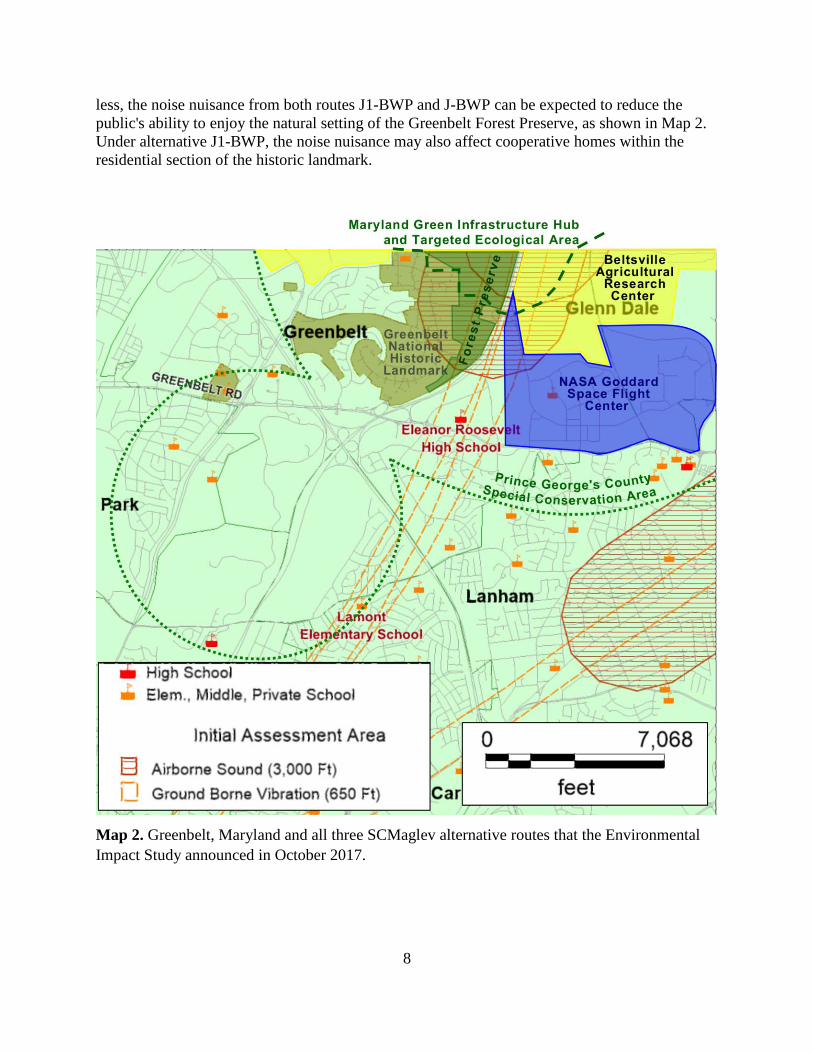
6. A Map of Bladensburg, Maryland
Map 3 shows the proposed underground SCMaglev routes passing through Bladensburg,
Maryland, where the train would potentially impact a number of economic, educational,
residential, and religious resources. One of the main advantages of the SCMaglev technology
(its high speed) leads to one of its main disadvantages: the tracks cannot make sharp turns to
avoid sensitive resources. Map 3 depicts a one-mile portion of the 36-mile trip from Washington
to Baltimore.
Because this portion of the track is underground, there is no airborne-sound nuisance. Federal
Railroad Administration guidelines, however, suggest that ground-transmitted vibrations may be
a nuisance in the yellow and orange areas in Map 3 assuming normal soil propagation. If
geologic tests determine that soil here is an efficient propagator of vibrations, then the larger area
enclosed by the purple lines in Map 3 might experience ground-vibration nuisance. Another
unknown is if any of the buildings along the path have resonance frequencies equal to those
generated by the SCMaglev, which could increase the impacts to these buildings.
In what might be described as stunningly poor choices for the track alignment, the proposed
SCMaglev routes go directly under two high schools, a high-rise residential building, and a
major retail center, all in the single mile in Bladensburg depicted in Map 3. According to
Federal Railroad Administration guidelines, ground vibrations from the Maglev tunnel would
likely impact these buildings, even assuming normal soil propagation. Were the soil here an
efficient propagator, then additional buildings could be impacted: a church, a community center,
a senior-living facility, medical offices, two elementary schools, and two more high-rise
residential buildings.
10
Map 3. Bladensburg, Maryland, and SCMaglev alternative routes announced by the
Environmental Impact Study in October 2017.
11
Part 2: Nuisance Distance
1. Overview Part II of the present document explains how the nuisance distances shown in the maps of Part I
were derived from Federal Railroad Administration guidelines. The nuisance distances stated in
the following tables go from track to observer, meaning that the total width of the nuisance zone
would be twice as great as the nuisance distance stated in the table. In other words, the nuisance
extends beyond the centerline of the track for an equal distance on each side of the track. The
noise and rapid-onset nuisances are associated only with the aboveground portion of the track.
In contrast, the ground-vibration nuisance extends an equal horizontal distance on either side of
the track regardless of whether the track is aboveground or underground according to FRA
(2012).
Throughout, 300 mph is used as the top speed of the maglev train even though a slightly higher
speed is stated by the environmental impact study (311 mph). Using a round number for the
train speed (i.e., 300 mph instead of 311 mph) in the present document avoids giving a false
impression that these rough estimates are more accurate than they are. Another reason to use
300 instead of 311 mph as the top speed in the calculations of the present document is that it
reduces the chance of overestimating the nuisance distances. At speeds of 300 mph, the distance
to which a nuisance extends from the track increases rapidly with train speed.
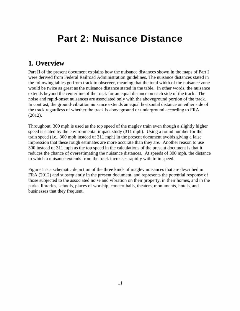
Figure 1 is a schematic depiction of the three kinds of maglev nuisances that are described in
FRA (2012) and subsequently in the present document, and represents the potential response of
those subjected to the associated noise and vibration on their property, in their homes, and in the
parks, libraries, schools, places of worship, concert halls, theaters, monuments, hotels, and
businesses that they frequent.
12
Figure 1. A schematic representation of three nuisances associated with a maglev train:
noise nuisance, ground-vibration nuisance, and rapid-onset nuisance.
2. Noise Nuisance
2.1. Initial screening for noise nuisance
There are three methodologies for identifying nuisances according to FRA (2012, pg. 4-2):
Initial Screening, Detailed Analysis, and General Assessment. Initial screening is a useful
technique because it can be applied when only a few parameters are known about the proposed
rail project and the impacted communities. The purpose of initial screening is to generate a list
of properties that are near enough to a proposed track alignment that these properties should be
examined more carefully by a subsequent "detailed analysis" (FRA 2012, pg. 5-1). A list of the
kinds of noise-sensitive features that one should look for during the initial screening is found in
FRA (2012, pg. 3-7). There is also a third method, whose complexity and accuracy lies
somewhere between initial screening and detailed analysis. This middle method is called a
"general assessment" (FRA 2012, pg. 4-4).
For a noise nuisance, one can read an initial-screening distance from FRA (2012) Table 4-1. To
choose a value from this table, one needs an estimate of the pre-existing noise conditions and the
13
speed of the train. The more quiet the pre-existing conditions, the further from the tracks that the
new maglev noise will be experienced as a nuisance. Aerodynamic noise dramatically increases
with train speed; therefor the noise of the maglev train's passage is a nuisance further from the
track when the train is traveling faster.
For the purpose of determining a noise-nuisance initial-screening distance, many residential
areas, parks, forests, and farmland might reasonably be treated as "quiet suburban." Table 4-6
and page 4-12 of FRA (2012) suggest that "loud suburban" conditions are likely to occur within
400 feet of a superhighway, within 200 feet of a major road with at least 300 trucks passing per
hour, or where the population density is high (≥10,000 persons per square mile).
Table 4-1 of FRA (2012) provides three variations on both quiet and loud suburban conditions.
From noisiest to most quiet, these three variants are that the new maglev track is being built next
to an existing highway, next to an existing train track, or in a location with no such transportation
infrastructure. Table 1 (below) of the present document was created by extracting values from
FRA (2012) Table 4-1 that correspond to the middle of these three variants (i.e., existing rail
corridor). The distances quoted in Table 1 of the present document would vary by no more than
100 feet if one of the other variants were chosen from FRA (2012) Table 4-1.
To use Table 1 of the present document, one needs an estimate of where along the proposed
aboveground track alignments the maglev train will be traveling at least 200 mph. Section 8.4 of
the present document provides such an estimate under the route alignments proposed in October
2017 for the Baltimore-Washington superconducting maglev rail project. In brief, section 8.4
estimates that the maglev train would likely be traveling 200 mph at least from Bladensburg to
Fort Meade. The ≥200 mph portion of the track would include the entire aboveground track of
the October 2017 proposed routes. The aboveground portion of the track goes from Greenbelt to
Fort Meade under alternatives J and J1, and from Glen Dale to Bowie and Fort Meade under
alternative E.
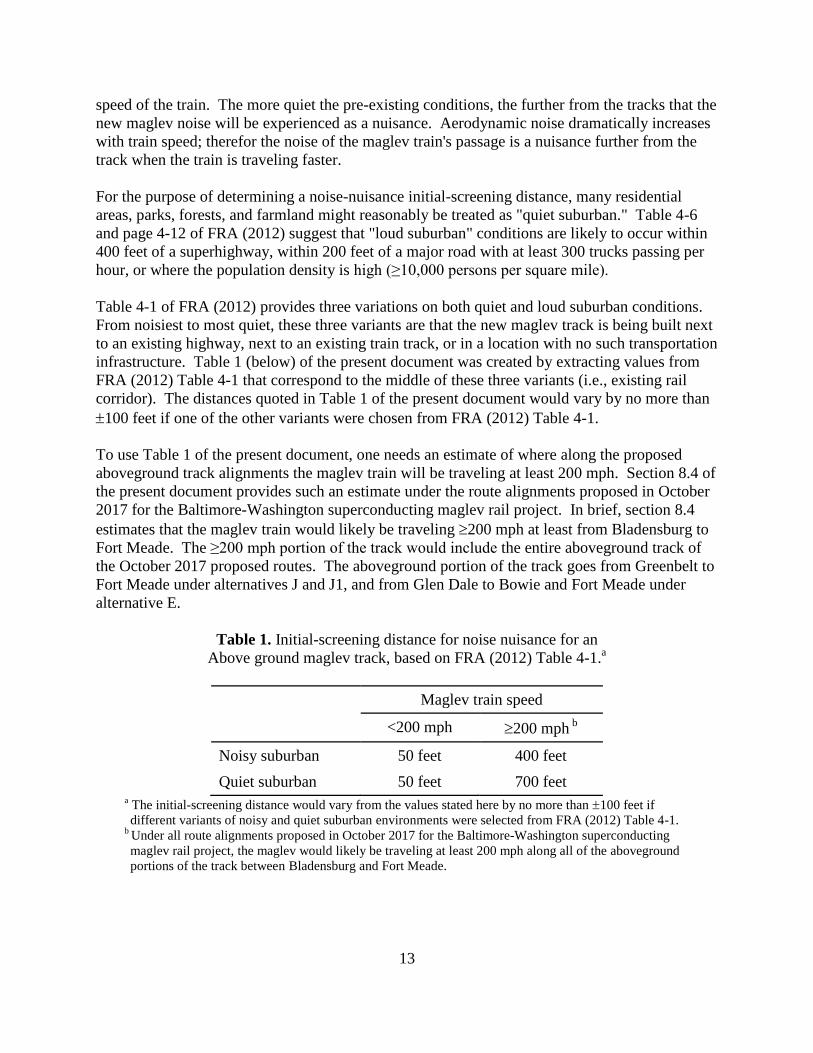
Table 1. Initial-screening distance for noise nuisance for an
Above ground maglev track, based on FRA (2012) Table 4-1.a
Maglev train speed
<200 mph 200 mph b
Noisy suburban 50 feet 400 feet
Quiet suburban 50 feet 700 feet a The initial-screening distance would vary from the values stated here by no more than 100 feet if
different variants of noisy and quiet suburban environments were selected from FRA (2012) Table 4-1. b Under all route alignments proposed in October 2017 for the Baltimore-Washington superconducting
maglev rail project, the maglev would likely be traveling at least 200 mph along all of the aboveground
portions of the track between Bladensburg and Fort Meade.

14
2.2. General assessment of noise nuisance
The FRA (2012) general-assessment method for noise nuisance involves more steps than the
just-described initial-screening technique for noise nuisance. Table 2 of the present document is
calculated using a simplified form of the FRA (2012) general-assessment method, as described in
detail in section 8.1 of the present document.
Comparing the initial screening (Table 1, above) with the general assessment (Table 2, below),
one sees that the general-assessment distance for 200 mph trains is generally consistent with the
initial-screening distance. For example, for quiet pre-existing conditions, the initial-screening
distance is 50 or 700 feet for trains traveling under or over 200 mph, while the general-
assessment distance is 366–498 feet for trains traveling at 200 mph depending on whether the
track is elevated or at ground level.
In contrast, the general-assessment distance for a maglev train traveling specifically at 300 mph
is considerably greater than the initial-screening distance for the broad category of all trains
traveling at least 200 mph. For example, under quiet pre-existing conditions and for 4 trains per
hour that travel 300 mph along an elevated track, the general-assessment noise nuisance would
extend 1,933 feet from the track. In comparison, the closest category in the initial screening
would be the noise nuisance extending 700 feet from the track if the trains were traveling at ≥200
mph in quiet pre-existing conditions. A plausible explanation for the difference between general
assessment and initial screening for a 300-mph train is that FRA (2012) may have optimized its
initial-screening "≥200-mph category" for trains that are traveling merely 200–250 mph, not 300
mph. Using the FRA formulas and inserting the 300-mph parameter, the distances specific to a
maglev train traveling at 300-mph can be extrapolated, as shown in Table2.
15
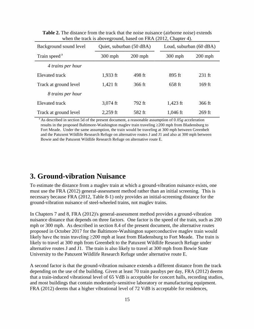
Table 2. The distance from the track that the noise nuisance (airborne noise) extends
when the track is aboveground, based on FRA (2012, Chapter 4).
Background sound level Quiet, suburban (50 dBA) Loud, suburban (60 dBA)
Train speed a 300 mph 200 mph 300 mph 200 mph
4 trains per hour
Elevated track 1,933 ft 498 ft 895 ft 231 ft
Track at ground level 1,421 ft 366 ft 658 ft 169 ft
8 trains per hour
Elevated track 3,074 ft 792 ft 1,423 ft 366 ft
Track at ground level 2,259 ft 582 ft 1,046 ft 269 ft a As described in section 5d of the present document, a reasonable assumption of 0.05g acceleration
results in the proposed Baltimore-Washington maglev train traveling 200 mph from Bladensburg to
Fort Meade. Under the same assumption, the train would be traveling at 300 mph between Greenbelt
and the Patuxent Wildlife Research Refuge on alternative routes J and J1 and also at 300 mph between
Bowie and the Patuxent Wildlife Research Refuge on alternative route E.
3. Ground-vibration Nuisance To estimate the distance from a maglev train at which a ground-vibration nuisance exists, one
must use the FRA (2012) general-assessment method rather than an initial screening. This is
necessary because FRA (2012, Table 8-1) only provides an initial-screening distance for the
ground-vibration nuisance of steel-wheeled trains, not maglev trains.
In Chapters 7 and 8, FRA (2012)'s general-assessment method provides a ground-vibration
nuisance distance that depends on three factors. One factor is the speed of the train, such as 200
mph or 300 mph. As described in section 8.4 of the present document, the alternative routes
proposed in October 2017 for the Baltimore-Washington superconductive maglev train would
likely have the train traveling ≥200 mph at least from Bladensburg to Fort Meade. The train is
likely to travel at 300 mph from Greenbelt to the Patuxent Wildlife Research Refuge under
alternative routes J and J1. The train is also likely to travel at 300 mph from Bowie State
University to the Patuxent Wildlife Research Refuge under alternative route E.
A second factor is that the ground-vibration nuisance extends a different distance from the track
depending on the use of the building. Given at least 70 train passbys per day, FRA (2012) deems
that a train-induced vibrational level of 65 VdB is acceptable for concert halls, recording studios,
and most buildings that contain moderately-sensitive laboratory or manufacturing equipment.
FRA (2012) deems that a higher vibrational level of 72 VdB is acceptable for residences,
16
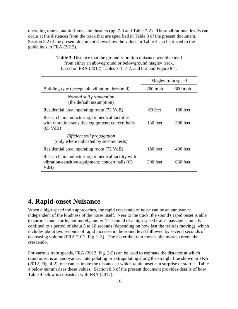
operating rooms, auditoriums, and theaters (pg. 7-3 and Table 7-2). These vibrational levels can
occur at the distances from the track that are specified in Table 3 of the present document.
Section 8.2 of the present document shows how the values in Table 3 can be traced to the
guidelines in FRA (2012).
Table 3. Distance that the ground-vibration nuisance would extend
from either an aboveground or belowground maglev track,
based on FRA (2012) Tables 7-1, 7-2, and 8-2 and Figure 8-1.
Maglev train speed
Building type (acceptable vibration threshold) 200 mph 300 mph
Normal soil propagation
(the default assumption)
Residential area, operating room (72 VdB) 60 feet 180 feet
Research, manufacturing, or medical facilities
with vibration-sensitive equipment; concert halls
(65 VdB)
130 feet 300 feet
Efficient soil propagation
(only where indicated by seismic tests)
Residential area, operating room (72 VdB) 180 feet 400 feet
Research, manufacturing, or medical facility with
vibration-sensitive equipment; concert halls (65
VdB)
300 feet 650 feet
4. Rapid-onset Nuisance When a high-speed train approaches, the rapid crescendo of noise can be an annoyance
independent of the loudness of the noise itself. Near to the track, the sound's rapid onset is able
to surprise and startle, not merely annoy. The sound of a high-speed train's passage is mostly
confined to a period of about 5 to 10 seconds (depending on how fast the train is moving), which
includes about two seconds of rapid increase in the sound level followed by several seconds of
decreasing volume (FRA 2012, Fig. 2-3). The faster the train moves, the more extreme the
crescendo.
For various train speeds, FRA (2012, Fig. 2-5) can be used to estimate the distance at which
rapid onset is an annoyance. Interpolating or extrapolating along the straight line shown in FRA
(2012, Fig. 4-2), one can estimate the distance at which rapid onset can surprise or startle. Table
4 below summarizes these values. Section 8.3 of the present document provides details of how
Table 4 below is consistent with FRA (2012).
17
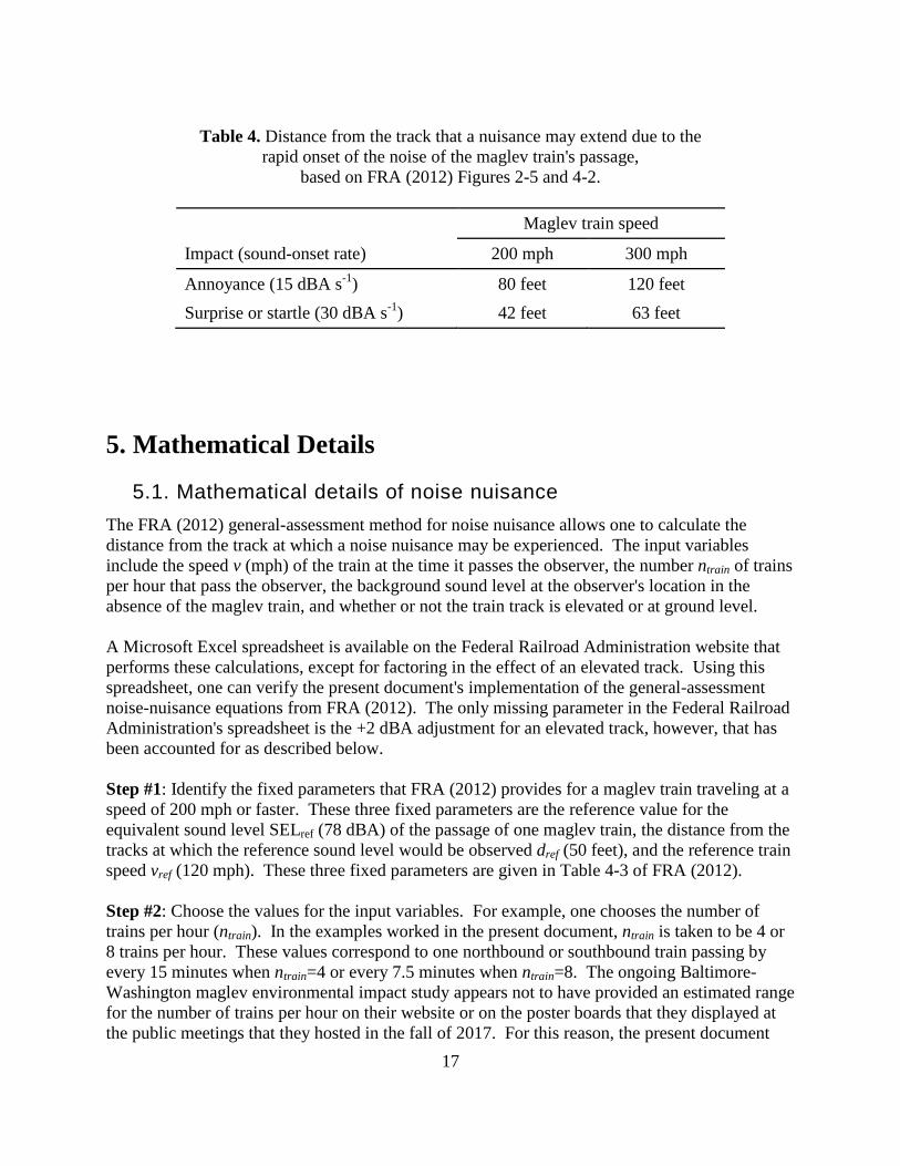
Table 4. Distance from the track that a nuisance may extend due to the
rapid onset of the noise of the maglev train's passage,
based on FRA (2012) Figures 2-5 and 4-2.
Maglev train speed
Impact (sound-onset rate) 200 mph 300 mph
Annoyance (15 dBA s-1
) 80 feet 120 feet
Surprise or startle (30 dBA s-1
) 42 feet 63 feet
5. Mathematical Details
5.1. Mathematical details of noise nuisance
The FRA (2012) general-assessment method for noise nuisance allows one to calculate the
distance from the track at which a noise nuisance may be experienced. The input variables
include the speed v (mph) of the train at the time it passes the observer, the number ntrain of trains
per hour that pass the observer, the background sound level at the observer's location in the
absence of the maglev train, and whether or not the train track is elevated or at ground level.
A Microsoft Excel spreadsheet is available on the Federal Railroad Administration website that
performs these calculations, except for factoring in the effect of an elevated track. Using this
spreadsheet, one can verify the present document's implementation of the general-assessment
noise-nuisance equations from FRA (2012). The only missing parameter in the Federal Railroad
Administration's spreadsheet is the +2 dBA adjustment for an elevated track, however, that has
been accounted for as described below.
Step #1: Identify the fixed parameters that FRA (2012) provides for a maglev train traveling at a
speed of 200 mph or faster. These three fixed parameters are the reference value for the
equivalent sound level SELref (78 dBA) of the passage of one maglev train, the distance from the
tracks at which the reference sound level would be observed dref (50 feet), and the reference train
speed vref (120 mph). These three fixed parameters are given in Table 4-3 of FRA (2012).
Step #2: Choose the values for the input variables. For example, one chooses the number of
trains per hour (ntrain). In the examples worked in the present document, ntrain is taken to be 4 or
8 trains per hour. These values correspond to one northbound or southbound train passing by
every 15 minutes when ntrain=4 or every 7.5 minutes when ntrain=8. The ongoing Baltimore-
Washington maglev environmental impact study appears not to have provided an estimated range
for the number of trains per hour on their website or on the poster boards that they displayed at
the public meetings that they hosted in the fall of 2017. For this reason, the present document
18
takes, as a starting point, the number of trains per hour that was published in the 2003 draft
environmental impact study for a maglev line between Baltimore and Washington, a maglev line
that was never built. Specifically, the 2003 study expected 2-5 trains per hour initially,
increasing to 8 trains per hour during peak hours "as ridership develops" (MDOT 2003, pg. ES-
13).
Also, one chooses from a table in FRA (2012) the correction factor C (dBA) that corresponds to
the track's relationship to ground level and any applicable sound shielding. For the examples
worked in the present document, it is assumed that the train track is either elevated (C = +2dBA)
or the track is at ground level (C = 0). One chooses the speed v (mph) of the train at the time it
passes the observer. For the examples worked in the present document, speed is taken to be 200
or 300 mph.
Step #3: Determine the pre-existing background noise level without any maglev trains. In a
quiet pre-existing environment, a quieter maglev sound would be sufficient to create a nuisance
(FRA 2012, Tables 3-4, 4-1, 4-2). In a louder pre-existing environment, a louder maglev sound
would be required to create a nuisance. FRA (2012) describes a quiet, suburban environment as
having a day-night sound level (Ldn) of 50 dBA, equivalent to that location having a constant
noise level of 50 dBA measured by a sound meter. Obviously, most environments have
fluctuating sound levels throughout the day, so to have a 50 dBA value for Ldn , the instantaneous
sound level would have to be somewhat lower than 50 dBA most of the time, punctuated by
periods when it exceeds 50 dBA. FRA (2012) describes a loud, suburban environment as having
a 60 dBA value for Lnd . As a point of reference, the U.S. Department of Housing and Urban
Development has determined that an ambient sound level of Ldn ≥65 dBA is inappropriate in
residential areas (FRA 2012, Appendix A, pg. A-13).
Step #4: Based on the pre-existing noise level, identify the cutoff for the amount of maglev-
generated noise that would constitute a nuisance. FRA (2012, Table 3-4) states the minimum
level (Ldn,cutoff ) of maglev-generated noise that would constitute a nuisance. In a quiet, suburban
environment (50 dBA background), a maglev-generated sound level that increases the total
sound level by 5 dBA is sufficient to create a nuisance (i.e., Ldn,cutoff = 53 dBA). In a loud
suburban environment (60 dBA background), a maglev-generated sound level that increases the
total sound level by 2 dBA is sufficient to create a nuisance (i.e., Ldn,cutoff = 58 dBA).
Step #5: Calculate the equivalent sound level SEL (dBA) generated by a single passage of the
train at the reference distance and the train's actual speed v (mph). The SEL is the sound level
during one second that would contain the same amount of sound energy as the actual 5–10
second sound of the passage of the train.
Eq. 1
Pausing the derivation for a moment, one can use Equation 1 to get a sense of how loud an
individual passby of the maglev train could be. Substituting a 300-mph speed into Equation 1
results in an equivalent sound level of 97.9 dBA = 78 + 50 log10( 300 mph / 120 mph ) at a 50-
foot distance from the track. The example in Figure 2-3 of FRA (2012) suggests that the
maglev's maximum sound level at a 50-foot distance from the track would be a few dB less (i.e.,
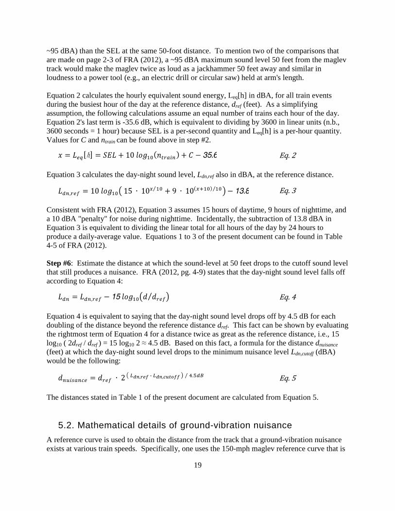
19
~95 dBA) than the SEL at the same 50-foot distance. To mention two of the comparisons that
are made on page 2-3 of FRA (2012), a ~95 dBA maximum sound level 50 feet from the maglev
track would make the maglev twice as loud as a jackhammer 50 feet away and similar in
loudness to a power tool (e.g., an electric drill or circular saw) held at arm's length.
Equation 2 calculates the hourly equivalent sound energy, Leq[h] in dBA, for all train events
during the busiest hour of the day at the reference distance, dref (feet). As a simplifying
assumption, the following calculations assume an equal number of trains each hour of the day.
Equation 2's last term is -35.6 dB, which is equivalent to dividing by 3600 in linear units (n.b.,
3600 seconds = 1 hour) because SEL is a per-second quantity and Leq[h] is a per-hour quantity.
Values for C and ntrain can be found above in step #2.
Eq. 2
Equation 3 calculates the day-night sound level, Ldn,ref also in dBA, at the reference distance.
Eq. 3
Consistent with FRA (2012), Equation 3 assumes 15 hours of daytime, 9 hours of nighttime, and
a 10 dBA "penalty" for noise during nighttime. Incidentally, the subtraction of 13.8 dBA in
Equation 3 is equivalent to dividing the linear total for all hours of the day by 24 hours to
produce a daily-average value. Equations 1 to 3 of the present document can be found in Table
4-5 of FRA (2012).
Step #6: Estimate the distance at which the sound-level at 50 feet drops to the cutoff sound level
that still produces a nuisance. FRA (2012, pg. 4-9) states that the day-night sound level falls off
according to Equation 4:
Eq. 4
Equation 4 is equivalent to saying that the day-night sound level drops off by 4.5 dB for each
doubling of the distance beyond the reference distance dref. This fact can be shown by evaluating
the rightmost term of Equation 4 for a distance twice as great as the reference distance, i.e., 15
log10 ( 2dref / dref ) = 15 log10 2 ≈ 4.5 dB. Based on this fact, a formula for the distance dnuisance
(feet) at which the day-night sound level drops to the minimum nuisance level Ldn,cutoff (dBA)
would be the following:
Eq. 5
The distances stated in Table 1 of the present document are calculated from Equation 5.
5.2. Mathematical details of ground-vibration nuisance
A reference curve is used to obtain the distance from the track that a ground-vibration nuisance
exists at various train speeds. Specifically, one uses the 150-mph maglev reference curve that is
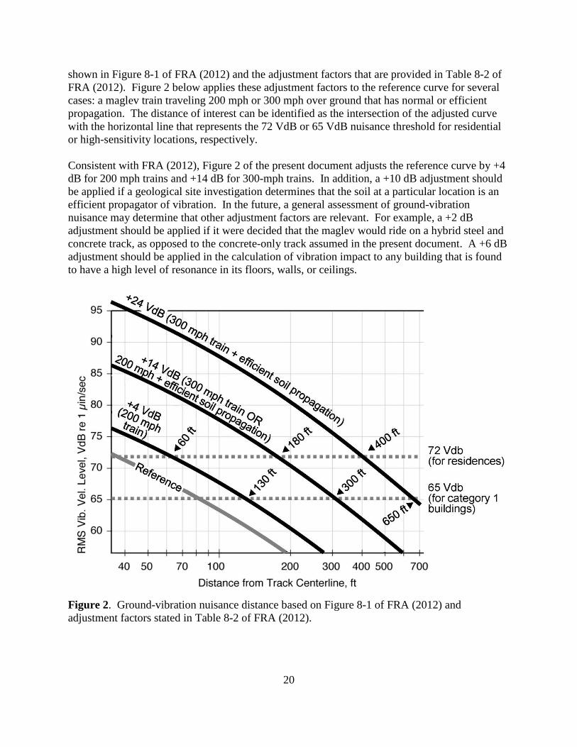
20
shown in Figure 8-1 of FRA (2012) and the adjustment factors that are provided in Table 8-2 of
FRA (2012). Figure 2 below applies these adjustment factors to the reference curve for several
cases: a maglev train traveling 200 mph or 300 mph over ground that has normal or efficient
propagation. The distance of interest can be identified as the intersection of the adjusted curve
with the horizontal line that represents the 72 VdB or 65 VdB nuisance threshold for residential
or high-sensitivity locations, respectively.
Consistent with FRA (2012), Figure 2 of the present document adjusts the reference curve by +4
dB for 200 mph trains and +14 dB for 300-mph trains. In addition, a +10 dB adjustment should
be applied if a geological site investigation determines that the soil at a particular location is an
efficient propagator of vibration. In the future, a general assessment of ground-vibration
nuisance may determine that other adjustment factors are relevant. For example, a +2 dB
adjustment should be applied if it were decided that the maglev would ride on a hybrid steel and
concrete track, as opposed to the concrete-only track assumed in the present document. A +6 dB
adjustment should be applied in the calculation of vibration impact to any building that is found
to have a high level of resonance in its floors, walls, or ceilings.
Figure 2. Ground-vibration nuisance distance based on Figure 8-1 of FRA (2012) and
adjustment factors stated in Table 8-2 of FRA (2012).
21
5.3. Mathematical details of rapid-onset nuisance
Research has found that the rapid crescendo of an approaching maglev train can be annoying or
startling to human subjects. FRA (2012) treats "rapid onset" as a separate nuisance factor from
the actual volume of the sound of a maglev train's passage.
Using the ratio shown in FRA (2012, Fig. 2-5), one can estimate the maximum distance from the
track at which rapid onset is an annoyance. Specifically, annoyance occurs when the onset rate
is at least 15 dBA per second, which occurs when the ratio between speed (mph) and distance
(feet) is 2.5. For a maglev train traveling at 200 or 300 mph, this ratio of 2.5 works out to an 80
or 120 foot distance from the track, respectively.
Figure 4-2 of FRA (2012) shows the distance from the track at which rapid onset can surprise
and startle. The startle effect occurs when the onset rate is at least 30 dBA per second, which
occurs up to 42 feet from the track at 200 mph. Extrapolating the straight line shown in Figure
4-2 of FRA (2012) from 250 to 300 mph, one estimates that, at 300 mph, the startle distance
would be 63 feet.
5.4. Variation in maglev speed as a function of distance from the
nearest station
The following schematic diagram depicts one possibility for the train-speed variation along the
two main track alignments proposed in October 2017 for the Baltimore-Washington
superconducting maglev project. This section explains why this speed-distance profile is a
reasonable guess; although it may be may an underestimate. This speed-distance profile assumes
a 300-mph top speed and an acceleration of 0.05g, i.e., a horizontal speed increase of 5% of the
acceleration due to gravity (9.8 m s-1
).
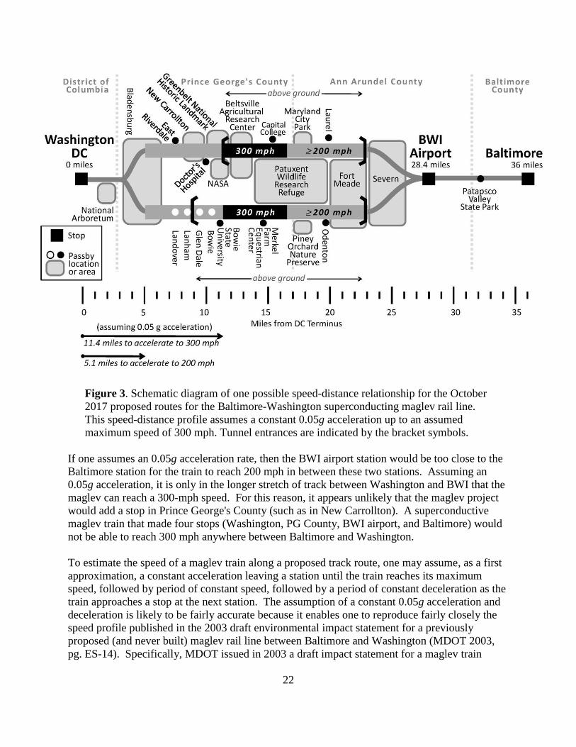
22
Figure 3. Schematic diagram of one possible speed-distance relationship for the October
2017 proposed routes for the Baltimore-Washington superconducting maglev rail line.
This speed-distance profile assumes a constant 0.05g acceleration up to an assumed
maximum speed of 300 mph. Tunnel entrances are indicated by the bracket symbols.
If one assumes an 0.05g acceleration rate, then the BWI airport station would be too close to the
Baltimore station for the train to reach 200 mph in between these two stations. Assuming an
0.05g acceleration, it is only in the longer stretch of track between Washington and BWI that the
maglev can reach a 300-mph speed. For this reason, it appears unlikely that the maglev project
would add a stop in Prince George's County (such as in New Carrollton). A superconductive
maglev train that made four stops (Washington, PG County, BWI airport, and Baltimore) would
not be able to reach 300 mph anywhere between Baltimore and Washington.
To estimate the speed of a maglev train along a proposed track route, one may assume, as a first
approximation, a constant acceleration leaving a station until the train reaches its maximum
speed, followed by period of constant speed, followed by a period of constant deceleration as the
train approaches a stop at the next station. The assumption of a constant 0.05g acceleration and
deceleration is likely to be fairly accurate because it enables one to reproduce fairly closely the
speed profile published in the 2003 draft environmental impact statement for a previously
proposed (and never built) maglev rail line between Baltimore and Washington (MDOT 2003,
pg. ES-14). Specifically, MDOT issued in 2003 a draft impact statement for a maglev train
23
based on German technology to operate between Baltimore and Washington with the same three
stops as the currently-proposed superconducting maglev rail line that is based on Japanese
technology.
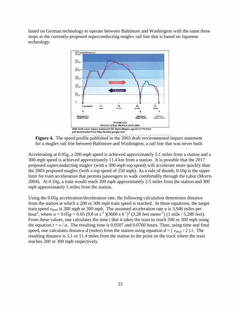
Figure 4. The speed profile published in the 2003 draft environmental impact statement
for a maglev rail line between Baltimore and Washington, a rail line that was never built.
Accelerating at 0.05g, a 200-mph speed is achieved approximately 5.1 miles from a station and a
300-mph speed is achieved approximately 11.4 km from a station. It is possible that the 2017
proposed superconducting maglev (with a 300-mph top speed) will accelerate more quickly than
the 2003 proposed maglev (with a top speed of 250 mph). As a rule of thumb, 0.10g is the upper
limit for train acceleration that permits passengers to walk comfortably through the cabin (Morris
2004). At 0.10g, a train would reach 200 mph approximately 2.5 miles from the station and 300
mph approximately 5 miles from the station.
Using the 0.05g acceleration/deceleration rate, the following calculation determines distance
from the station at which a 200 or 300 mph train speed is reached. In these equations, the target
train speed vfinal is 200 mph or 300 mph. The assumed acceleration rate a is 3,946 miles per
hour2, where a = 0.05g = 0.05 (9.8 m s
-2 )(3600 s h
-1)2 (3.28 feet meter
-1) (1 mile / 5,280 feet).
From these values, one calculates the time t that it takes the train to reach 200 or 300 mph using
the equation t = v / a. The resulting time is 0.0507 and 0.0760 hours. Then, using time and final
speed, one calculates distance d (miles) from the station using equation d = ( vfinal / 2 ) t. The
resulting distance is 5.1 or 11.4 miles from the station to the point on the track where the train
reaches 200 or 300 mph respectively.
24
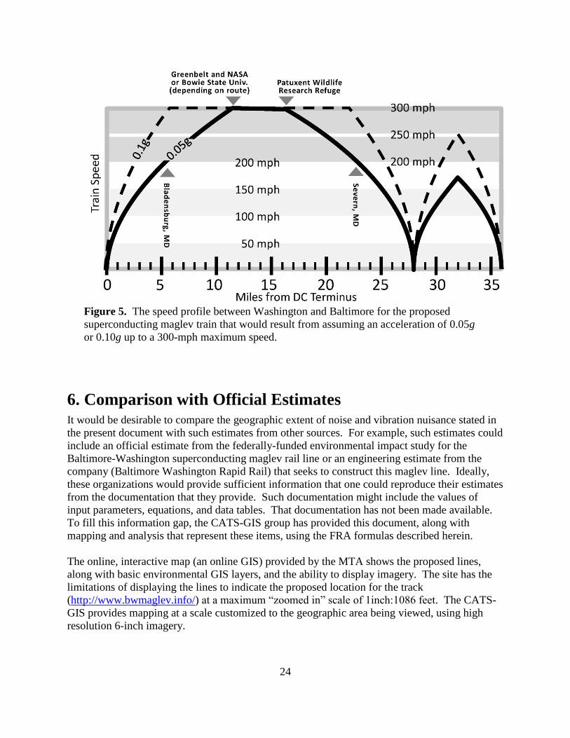
Figure 5. The speed profile between Washington and Baltimore for the proposed
superconducting maglev train that would result from assuming an acceleration of 0.05g
or 0.10g up to a 300-mph maximum speed.
6. Comparison with Official Estimates It would be desirable to compare the geographic extent of noise and vibration nuisance stated in
the present document with such estimates from other sources. For example, such estimates could
include an official estimate from the federally-funded environmental impact study for the
Baltimore-Washington superconducting maglev rail line or an engineering estimate from the
company (Baltimore Washington Rapid Rail) that seeks to construct this maglev line. Ideally,
these organizations would provide sufficient information that one could reproduce their estimates
from the documentation that they provide. Such documentation might include the values of
input parameters, equations, and data tables. That documentation has not been made available.
To fill this information gap, the CATS-GIS group has provided this document, along with
mapping and analysis that represent these items, using the FRA formulas described herein.
The online, interactive map (an online GIS) provided by the MTA shows the proposed lines,
along with basic environmental GIS layers, and the ability to display imagery. The site has the
limitations of displaying the lines to indicate the proposed location for the track
(http://www.bwmaglev.info/) at a maximum “zoomed in” scale of 1inch:1086 feet. The CATS-
GIS provides mapping at a scale customized to the geographic area being viewed, using high
resolution 6-inch imagery.
25
In 2017, poster boards describing the Baltimore-Washington maglev project were available on
the environmental impact study's website (http://www.bwmaglev.info/), but they lack even a
rough estimate of the geographic extent of the noise and vibration nuisance. This set of poster
boards was also on display at public meetings hosted by the environmental impact study in the
fall of 2017. To fill this information gap, the CATS-GIS group has provided the mapping and
analysis that represents these items, using the FRA formulas described in this document.
In addition, there were some poster boards that did contain information about noise and vibration
that were displayed at the fall 2017 public meetings, but this second set of poster boards does not
appear on the website of the maglev environmental impact study, at the time of the writing of
this document. After some research, this second set of poster boards was located among the
"marketing material" on the website of The Northeast Maglev company
(http://northeastmaglev.com; TNEM 2017).
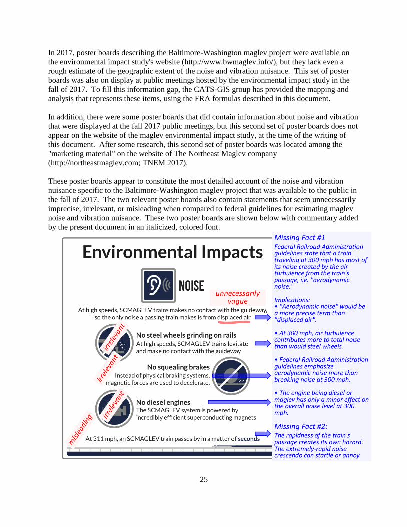
These poster boards appear to constitute the most detailed account of the noise and vibration
nuisance specific to the Baltimore-Washington maglev project that was available to the public in
the fall of 2017. The two relevant poster boards also contain statements that seem unnecessarily
imprecise, irrelevant, or misleading when compared to federal guidelines for estimating maglev
noise and vibration nuisance. These two poster boards are shown below with commentary added
by the present document in an italicized, colored font.
26
Figure 6. A poster board displayed at a public meeting hosted by the environmental
impact study in the fall of 2017. This poster board describes, to a degree, the noise
nuisance that would be generated by the passage of the proposed Baltimore-Washington
superconducting maglev train (black text). The present document adds commentary in
red and blue italicized text.
The poster board shown in Figure 6 lacks a quantitative estimate of the geographic extent of the
maglev noise nuisance, and furthermore, it fails to mention relevant facts from FRA (2012).
First, FRA (2012) states that most of the noise associated with a 300-mph train's passage is
generated by air turbulence, i.e., aerodynamic noise. An important implication of this fact is that
the type of engine (maglev or non-maglev) has little impact on the overall noise level of a train
traveling at 300 mph. Second, FRA (2012) states that the rapidness of the passage of a 300-mph
train actually introduces a new hazard that is not present for trains traveling at slower speeds.
Specifically, the rapid passage of the train causes a rapid onset of noise, which can startle or
annoy.
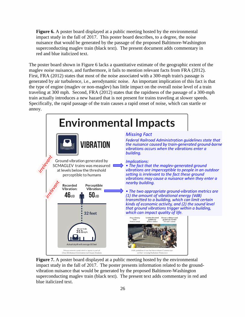
Figure 7. A poster board displayed at a public meeting hosted by the environmental
impact study in the fall of 2017. The poster presents information related to the ground-
vibration nuisance that would be generated by the proposed Baltimore-Washington
superconducting maglev train (black text). The present text adds commentary in red and
blue italicized text.
27
The poster board shown in Figure 7 states a misleading, yet quantitative, estimate of the maglev
vibration nuisance, and furthermore, it fails to mention a relevant fact. Federal Railroad
Administration guidelines (FRA 2012) state that high-speed trains can generate ground-borne
vibrations that are imperceptible to humans in an outdoor setting, but which nonetheless can
create a hazard when these ground vibrations enter a building. The poster board shown in Figure
7 gives a value for the wrong variable (i.e., the vibrational energy experienced outside), rather
than providing values of the appropriate variables at various distances from the maglev track
(i.e., the vibrational energy transmitted to a building and the ground-vibration-induced noise
level inside of a building).
There are implications to the apparent low-quality of information that the parties to the
Baltimore-Washington maglev environmental impact study have provided the public in relation
to noise and vibration along the proposed maglev track. The low-quality of information
recommends that one critically evaluate any numerical estimate of the geographic extent of noise
and vibration nuisance that parties to the environmental impact study may publish in the future.
Before accepting such estimates as accurate, complete, or reliable, it may be desirable to double-
check each step of the related calculations that were performed by the environmental impact
study. To do so, it might be necessary to hire a consulting engineer who is independent of the
environmental impact study.
28
References
Anne Arundel County, Maryland. County Maps & GIS Data. http://www.aacounty.org/county-
maps/. Retrieved July 2017.
Federal Railroad Administration (FRA), 2012: High-speed Ground Transportation Noise and
Vibration Impact Assessment, final report, September 2012. U.S. Department of
Transportation, DOT/FRA/ORD-12/15, 248 pp. Available online at
https://www.fra.dot.gov/eLib/details/L04090.
LexisNexis. Maryland Code and Court Rules. Code of Maryland Unannotated and Rules.
https://advance.lexis.com/container?config=00JAA1NTM5MzBmZC02MTg2LTQzNmEtY
mI5Yy0yZWEwYzA1OGEwNTYKAFBvZENhdGFsb2fdgr2eooaZj7MpSZGOIwWq&crid
=b8007635-4a2b-4e07-9069-08065340e558&prid=35278021-b551-429a-b572-
2367cbd35847. Retrieved August 2017.
Maryland Department of Planning. Open Data GIS downloads. http://planning.maryland.gov/.
Retrieved July 2017.
Maryland Department Of Transportation (MDOT), 2003: Baltimore-Washington Maglev Project,
Draft Environmental Impact Statement and Section 4(f) Evaluation, volume 1, October 2003.
Available online at http://books.google.com.
Maryland Department Of Transportation (MDOT), 2017: Baltimore-Washington
superconducting maglev project environmental study, web site. Available online at
http://www.bwmaglev.info/.
Maryland Public Service Commission. Case No. 9363. In the Matter of the Application of
Baltimore Washington Rapid Rail, LLC for Transfer of Abandoned Railroad Franchise.
http://www.psc.state.md.us/commission-orders/. Retrieved September 2017.
Morris, C., 2004: Two performance parameters-When acceleration is more important than speed
in modern ground transportation systems. conference paper, 18th International Conference on
Magnetically Levitated Systems and Linear Drives, Shanghai, China. Available online at
http://www.maglev.ir/eng/documents/papers/conferences/maglev2004/topic1/IMT_CP_M20
04_T1_25.pdf.
Planning Department of Prince George’s County, Maryland. GIS Open Data Portal.
http://gisdata.pgplanning.org/opendata/. Retrieved July 2017.
TNEM, 2017: Public Outreach Boards, Marketing Materials section of the Media webpage of the
website of The Northeast Maglev (TNEM) corporation. Environmental impacts are described
on posters 8 and 9, which cover noise and vibration, respectively. Available online at
http://northeastmaglev.com/wp-content/uploads/2017/02/TNEM-BWRR-Public-Meeting-
Posters.pdf and http://northeastmaglev.com/media/.
Wikipedia, 2017: SCMaglev. Available online at https://en.wikipedia.org/wiki/SCMaglev.
United States Bureau of Census. Geo-TIGER files. ftp://ftp2.census.gov/geo/tiger/TIGER2016/.
Retrieved August 2017.


