1
Land Administration and Cadastral Trends –A Framework for Re-Engineering
Ian WilliamsonProfessor of Surveying and Land Information
Department of GeomaticsThe University of Melbourne
Parkville, Victoria 3052, AustraliaTel: + 61-3- 9344 4431; Fax: + 61-3-9347 4128
Email: [email protected]: www.sli.unimelb.edu.au/people/ipw.html
Lisa Ting BA, LLB, LLMPhD candidate
Department of GeomaticsThe University of Melbourne
Parkville, Victoria 3052, AustraliaTel: + 61-3- 9344 9696; Fax: + 61-3-9347 2916
Email: [email protected]
Presented at the UN-FIG Conference on Land Tenure and CadastralInfrastructures for Sustainable Development, Melbourne, Australia
24-27 October 1999
ABSTRACTThis paper is the second of two papers which look at the changing humankind-land relationship over the centuries, the resulting land administration andcadastral responses to this change and future trends. The first paper examinesland administration and cadastral trends in the context of global drivers ofsustainable development, the changing humankind-land relationship,globalisation, micro-economic reform and technology. It sets the scene for a newworld order in land administration which takes a more integrated approach ratherthan the historic fragmented approach. This paper reviews the need for a newland administration vision and examines change management of landadministration and cadastral systems in the context of the global drivers. Thisresults in the development of a framework for re-engineering land administrationsystems. After discussing a land administration vision the paper reviews trendsand issues in the context of this framework.
Keywords and phrases: Land administration, cadastre, cadastral reform, vision, spatial datainfrastructures, spatial information management, GIS, WWW, IT, spatial hierarchy
INTRODUCTIONGlobal drivers such as sustainable development, globalisation, micro-economicreform and technology are changing the way humankind relates to land. Thischanging relationship requires new land administration infrastructures and tools. As aresult existing land administration and cadastral systems are being re-engineered.This paper is the second of two papers attempting to understand the changinghumankind-land relationship and the resulting land administration and cadastralinfrastructures required to support it.
2
The first paper (Ting and Williamson, 1999) is concerned with the changinghumankind-land relationship over the centuries, with a focus on recent global driversfor change. It uses New Zealand as a case study in understanding the need for newland administration infrastructures. As a result of the global drivers, it concludes thatsocieties will in future have to manage land in a different or revolutionary way, withland administration having to take a much broader and integrated view than wasoften the case in the past. The following section describes a new world order for landadministration based on the first paper.
This second paper builds on the scenario to consider a new vision for landadministration and develops a framework for re-engineering future landadministration systems to achieve the vision. The paper also examines some of thetrends and issues concerned with moving to a new land administration vision. Centralto this paper is the over-riding principle that land administration and cadastralsystems are a key component of the infrastructure that supports and facilitates theway that society interacts with land to ensure the sustainability of humanity.
A NEW WORLD ORDERThe global drivers identified above influence the development of the different landadministration polices and models adopted by governments, with an obvious flow onto the private sector. These models and concepts can only be developed with a clearunderstanding of current land administration issues and trends. By its very nature,land administration focuses on land tenure and cadastral (land parcel related) issues.The land administration perspective includes understanding the changinghumankind-land relationship, land tenure issues such as native title, institutional andadministrative issues such as the relationship between infrastructures and thebusiness systems they support, and technical issues such as those concerned with theuse of the World Wide Web (WWW).
A review of the dynamic humankind-land relationship by Ting and Williamson(1999) shows that it may be classified into four broad phases:
• Human settlement during the agricultural revolution through to the feudal system,which tied human beings to land in a physical way. Land was the primarysymbol and source of wealth. In this phase, the cadastral system’s role was topublicly record ownership as well as for fiscal purposes.
• The Industrial Revolution began a process of breaking that strong physical tie toland by turning land into more of a commodity, albeit the most valuablecommodity and primary source of capital. This environment gave birth to landmarkets and so cadastre took on another focus – a tool to support land transferand land markets.
• The post-World War II reconstruction and the population boom saw anawareness of land as a scarce resource that was not sufficient for the needs of agrowing world population which was becoming more mobile. With this came aninterest in planning, particularly urban and regional planning. Planning in turncreated another application for cadastre.
3
• The 1980s have seen a different twist in the concern for the scarcity of land. Thefocus has turned to wider issues of environmental degradation and sustainabledevelopment, as well as social equity. All of these issues have the probableeffect of tempering short-term economic imperatives. Planning issues havewidened to include more community interests and deepened to address moredetailed issues of land use. This has created a growing need for more complexinformation about land and land use. The impact of these has been manifested inthe desire for multi-purpose cadastres.
Many countries are in the course of making the transition from the third to the fourthphases. Apart from examining local or national legal, institutional, economic andsocial frameworks, the current era requires that nations take into consideration theglobal drivers such as sustainable development, globalization, micro-economicreform (privatization) and the information revolution.
Sustainable development, as exemplified by the internationally acclaimed instrumentAgenda 21, brings environmental issues and social forces such as indigenous andwomen’s rights into the realm of influence alongside and often in opposition to,traditional economic considerations. It is this dynamic which starts to bring landadministration and land management into closer and even overlapping proximity.
Sustainable development is also linked to globalization. Globalization means theprocess of greater interconnectedness between societies and jurisdictions from asocial, economic and political perspective, such that events in one part of the worldhave more potential to impact on peoples and societies in other parts of the world. Aglobalized world is one in which political, economic, cultural and social eventsbecome more interconnected.
The globalization of markets has in turn influenced micro-economic reform. Thisreform has translated into the radical down-scaling of government, privatisation ofservices and some policy functions, and the introduction of a competition andservice-oriented philosophy into the remaining government activities. Some refer tothis as the “user-pays” philosophy. Often this results in a tension with the “universalenvironment” and public good approach.
These tensions emphasise the need for complex and sophisticated decision-makingwhich, in the context of micro-economic reforms, means not only in government butthe private sector and wider community. Civil society demands a place in theframework of decision-making. Here, information technology and the informationrevolution have the potential to make the vision a reality. The WWW is just oneexample of the potential that exists to bring consultation and participation to a newlevel of effectiveness. Sustainable development, by its very nature, requirescommunity involvement and ownership, whether we are referring to the localcommunity or the global community. It is thus imperative that the legal andinstitutional structures adapt to facilitate these changes.
It is in the context of this new world order that the next generation of landadministration systems will have to be developed. This new order lays thefoundations and sets the parameters for these new systems which have to be muchbroader and integrated than the approaches of the past.
4
TOWARDS THE BATHURST DECLARATIONLand administration and cadastral systems are continually evolving as society’sattitudes and relationship to land changes. As this relationship with land becomesmore complex in terms of the ever increasing number and form of rights,responsibilities and obligations, our land administration information systems thatsupport decision-making, primarily in support of sustainable development, must alsoadapt to remain relevant. The resulting land administration and cadastral reformswhich have developed across many jurisdictions worldwide over the last 20 years,give an insight into the issues and trends in both land administration and supportingspatial information systems.
Land administration and cadastral systems can no longer rely on manual processes ortraditional structures that supported individual economic or taxation imperatives inthe past. Stand alone or isolated approaches that supported individual purposeswhere data and processes were maintained separately, such as land valuation andland titling, are not sustainable. They are being replaced by multipurpose cadastralsystems where information about natural resources, planning, land use, land valueand land titles, including Western and indigenous interests, can be integrated for arange of business purposes. As we move further into the information revolution, aclear vision of what land administration and cadastral systems might look like in adecade or so is becoming more urgent.
The United Nations and organisations such as the International Federation ofSurveyors (FIG) have for many years undertaken studies to understand and describeland administration systems and particularly the cadastral component. The interest inland administration infrastructures has been growing over the last few years as aresult of the changes necessitated by the global drivers mentioned above but alsobecause of the fall of apartheid in Southern Africa and the changes from command tomarket economies in Eastern and Central Europe. A key component in most of thesestudies has been to develop a new land administration vision for a changing worldand to explore the issues required to achieve such a vision.
The UN Regional Cartographic Conference (UNRCC) for Asia and the Pacific heldin Beijing in 1994 passed a resolution to organise a joint UN-FIG Inter-RegionalMeeting of Experts on Cadastre. The resulting meeting was held in Bogor, Indonesia,in March 1996, the primary objective of the meeting being “to develop a documentsetting out the desirable requirements and options for cadastral systems ofdeveloping countries in the Asia and Pacific region and to some extent globally”. Asa result of the success of the Bogor Declaration on Cadastral Reform (UN-FIG,1996), the FIG presented the Declaration at two subsequent UNRCCs for Asia andthe Pacific in Bangkok and for the Americas in New York, in 1997.
While the Bogor Declaration resulted in a valuable contribution to a betterunderstanding of cadastral reform, the delegates to the meeting recognised itsrelatively narrow focus and acknowledged the lack of representation from a widerange of land related experts. As a result one of the recommendations from theBangkok UNRCC was to organise by 1999 a global workshop on land rights,responsibilities and restrictions and suitable cadastral structures and systems
5
appropriate to the needs of governments for their sustainable development. Thislatter meeting was to take a broader view of land administration and would draw on awide range of experts. Assistance was to be sought from the FIG to organise themeeting. This recommendation has resulted in the current Workshop andInternational Conference on Land Tenure and Cadastral Infrastructures forSustainable Development jointly organised between the UN and the FIG. The majoroutcome will be the Bathurst Declaration. There was a recognition in the 1997 UNresolution that the 1999 initiative would build on the vision, guidelines and policiesproposed in the previous UN-FIG Bogor Declaration.
The Bogor Declaration adopted the definition and description of a cadastre as set outin the FIG Statement on the Cadastre (FIG, 1995). Reference was also made to thetwo previous UN meetings of cadastral experts (in 1972 and 1985) and the LandAdministration Guidelines prepared by the Meeting of Officials on LandAdministration (MOLA, 1999) of the United Nations Economic Commission forEurope in 1996.
A central component of the Bogor Declaration is a cadastral vision of the future. Thisvision and the supporting guidelines, and cadastral reform options and principleshave formed a starting point for the development of the Bathurst Declaration.Another input into the development of the vision for a future land administrationinfrastructure is the FIG report on future cadastral systems “Cadastre 2014”(Kaufmann, 1998 and Kaufmann and Steudler, 1998).
This ongoing work of the UN and FIG resulted in the objective of the BathurstDeclaration being:
To explore humankind-land relationships for the next millennium in the contextof AGENDA 21 and the emerging global village. It will determine a broadvision and a set of guidelines for suitable cadastral structures and systems tosupport land management and in particular land administration to ensuresustainable development and environmental management. It will focus on thelegal, technical and institutional infrastructure required to support such avision. The workshop will recognise the trend for formal land tenure systems tomove from a focus on ownership to one of land rights, responsibilities andrestrictions.
The workshop and conference, and the resulting Bathurst Declaration, are anotherstep in the growing awareness of the importance of land administration and cadastralsystems in support of sustainable development. This paper suggests a way forwardfor land administration systems which can build on the new Bathurst Declaration.The paper proposes a model to re-engineer land administration systems and thenlooks closely at two of the most important phases in the process - the development ofa land administration vision and implementation issues.
6
Global Drivers for Change
Land Administration andCadastral Environment
Implementation Issues
Figure 1. Hierarchy of Perspectives
LAND ADMINISTRATION AND CADASTRAL REFORMThe necessity for change in land administration and cadastral systems is highlightedin many reports and statements and is a growing focus for organisations such as theUnited Nations, the World Bank and the International Federation of Surveyors. TheBogor Declaration argues for change, documents a vision and describes the necessityfor re-engineering systems. Cadastre 2014 describes a new vision for cadastralsystems. The MOLA Land Administration Guidelines establish a framework for landadministration reform with a focus on Central and Eastern Europe. More importantlyland administration and cadastral systems world-wide are currently undergoing majorchanges. In understanding present trends it is useful to understand this change.
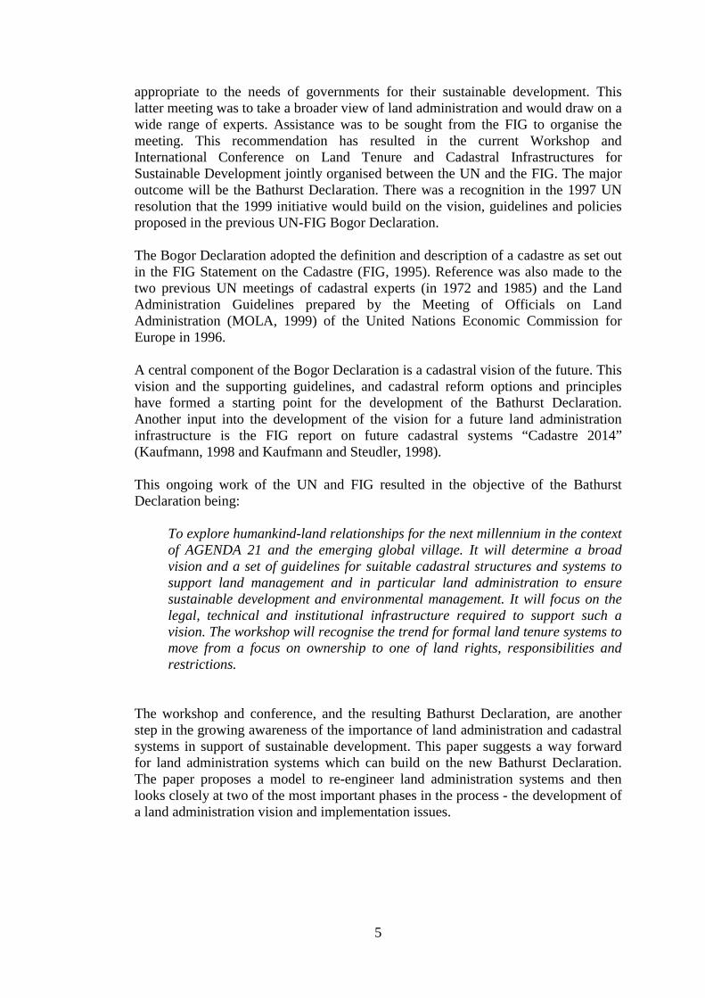
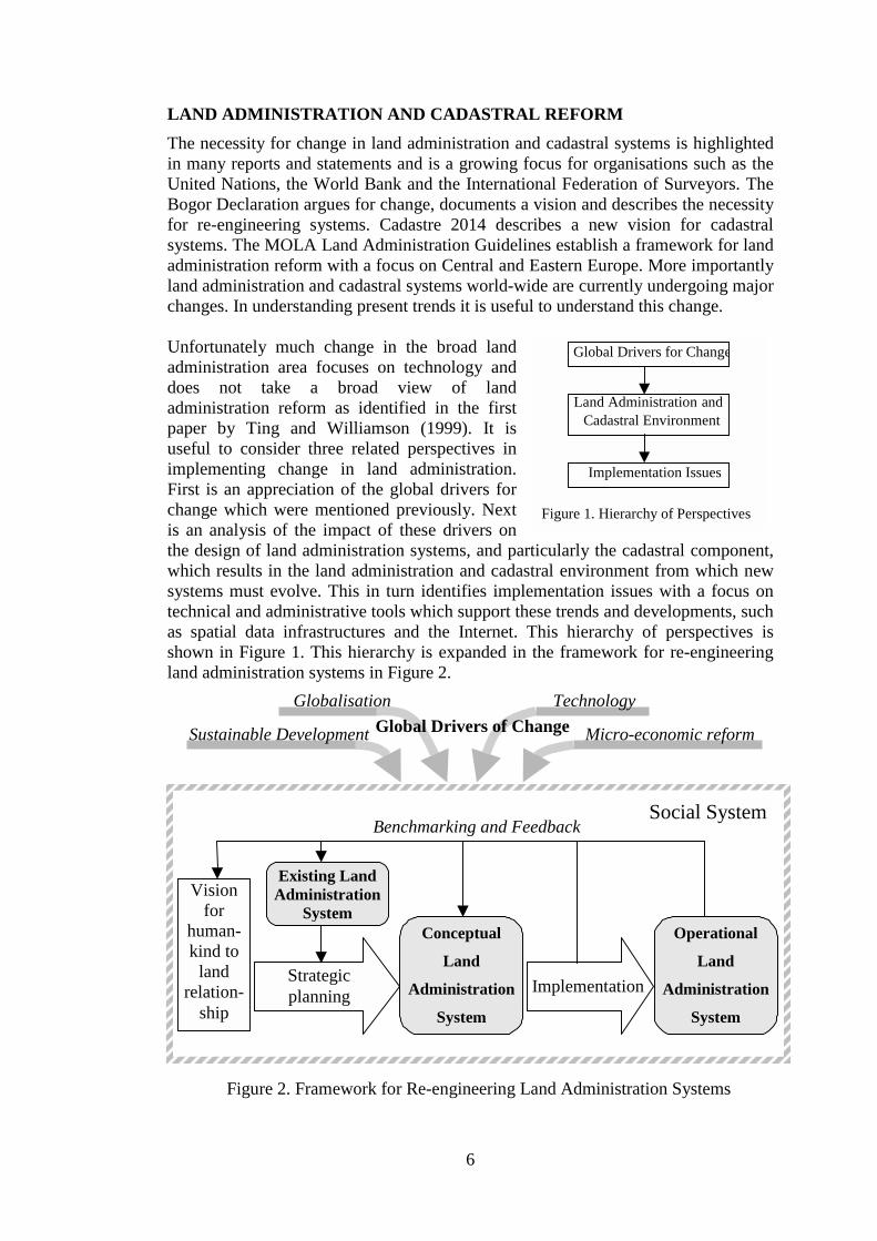
Unfortunately much change in the broad landadministration area focuses on technology anddoes not take a broad view of landadministration reform as identified in the firstpaper by Ting and Williamson (1999). It isuseful to consider three related perspectives inimplementing change in land administration.First is an appreciation of the global drivers forchange which were mentioned previously. Nextis an analysis of the impact of these drivers onthe design of land administration systems, and particularly the cadastral component,which results in the land administration and cadastral environment from which newsystems must evolve. This in turn identifies implementation issues with a focus ontechnical and administrative tools which support these trends and developments, suchas spatial data infrastructures and the Internet. This hierarchy of perspectives isshown in Figure 1. This hierarchy is expanded in the framework for re-engineeringland administration systems in Figure 2.
Figure 2. Framework for Re-engineering Land Administration Systems
Visionfor
human-kind to
landrelation-
ship
Strategicplanning
Benchmarking and Feedback
Existing LandAdministration
SystemConceptual
Land
Administration
System
Operational
Land
Administration
System
Social System
Sustainable Development
Globalisation
Micro-economic reformGlobal Drivers of ChangeTechnology
Implementation
7
In this framework global drivers impact on the whole social system which comprisesthe re-engineering process. The framework shows that through a strategic planningprocess, the vision of a new humankind-land relationship, together with the existingland administration system, results in the development of a conceptual landadministration system. Through an implementation process an operational landadministration system is developed. Through benchmarking and feedback, the visionand conceptual system will be continually refined. Some of the key strategicplanning and implementation issues within the re-engineering process, such as therole of native title, the changing nature of spatial data infrastructures, understandingthe business-infrastructure relationship in spatial information management, the use ofthe WWW and benchmarking processes, are discussed later in the paper.
One of the key steps in the re-engineering process, being the determination of thevision for the humankind-land relationship and the resulting conceptual landadministration system, is discussed below.
DEVELOPING A LAND ADMINISTRATION VISIONOver the years a number of land administration or cadastral models or visions havebeen developed. Two of the most notable are described in the FIG Statement on theCadastre (FIG, 1995) and the Bogor Declaration on Cadastral Reform (UN-FIG,1996). Cadastre is defined in the Statement on the Cadastre as :
… normally a parcel based and up-to-date land information systemcontaining a record of interests in land (e.g. rights, restrictions andresponsibilities). It usually includes a geometric description of land parcelslinked to other records describing the nature of the interests, and ownershipor control of those interests, and often the value of the parcel and itsimprovements. It may be established for fiscal purposes (e.g. valuation andequitable taxation), legal purposes (conveyancing), to assist in themanagement of land and land use (e.g. for planning and other administrativepurposes), and enables sustainable development and environmentalprotection.
The Bogor Declaration on Cadastral Reform (UN-FIG, 1996) expanded thisdefinition to state that future cadastres would:
• develop modern cadastral infrastructures that facilitate efficient land and propertymarkets, protect the land rights of all, and support long term sustainabledevelopment and land management.
• facilitate the planning and development of national cadastral infrastructures sothat they may fully service the escalating needs of greatly increased urbanpopulations. These will result from the rapid expansion of cities that is alreadytaking place and which is projected to continue into the 21st century.
This vision incorporated the concept of cadastral systems as infrastructures andhighlighted the role of cadastres in the operation of land markets. While theStatement on the Cadastre was in reality a definition, the Bogor Declaration was
8
more concerned with strategic and implementation issues, albeit in the relativelynarrow cadastral sense.
Williamson (1996) developed a 10 year land information management vision for theState of Victoria, Australia, which would be a central component of any future landadministration system. It built on his involvement with the development of theStatement on the Cadastre and the Bogor Declaration in addition to it receivingvaluable input from many colleagues. This vision took a more information systemsview of modern land administration and cadastral systems. It is summarised asfollows:
Simply within ten years all tiers of government, the private sector and thewider public will have controlled access to a standardised, complete, nation-wide, current, on-line land information system in real time, which is efficient,economically justified and compatible with other information systems.
A more recent investigation of future cadastral systems is the FIG Cadastre 2014vision (Kaufmann, 1998 and Kaufmann and Steudler, 1998). This was commissionedin 1994 by one of the Working Groups of Commission 7 (Cadastre and LandManagement) as a 20 year vision. The final report was the result of a four-yearprocess involving input from many countries world wide. Cadastre 2014 recognisesthe changing relationship of humankind to land, the changing role of governments insociety, the impact of technology on cadastral reform, the changing role of surveyorsin society and the growing role of the private sector in the operation of the cadastre.
Cadastre 2014 is defined as a methodically arranged public inventory of dataconcerning all legal land objects in a certain country or district, based on asurvey of their boundaries. Such legal land objects are systemmaticallyidentified by means of some separate designation. They are defined by eitherprivate or public law. The boundaries, the identifier together with descriptivedata, may show for each separate land object the nature, size, value and legalrights and restrictions associated with the land object.
Cadastre 2014 has made a valuable contribution to the understanding of futurecadastral systems. However it did by design restrict its focus on cadastral systemsand emphasised technological changes.
Another document which has influenced land administration and cadastral thinkingover the last few years is the Land Administration Guidelines produced by theEuropean Meeting of Officials on Land Administration (MOLA) for the UNEconomic Commission for Europe (MOLA, 1999). The MOLA Guidelines took awider view of land administration incorporating land registration, land valuation andplanning, however by design they focused on land administration and cadastralreform in Eastern and Central Europe.
One result from all these initiatives is the trend for future land administration andcadastral systems to take a broader and more integrated view than in the past. Thecomponents of land registration, cadastral surveying and mapping, planning and landvaluation, and their role in the operation of land markets, must all be considered asone integrated system where the common objective is sustainable development. A
9
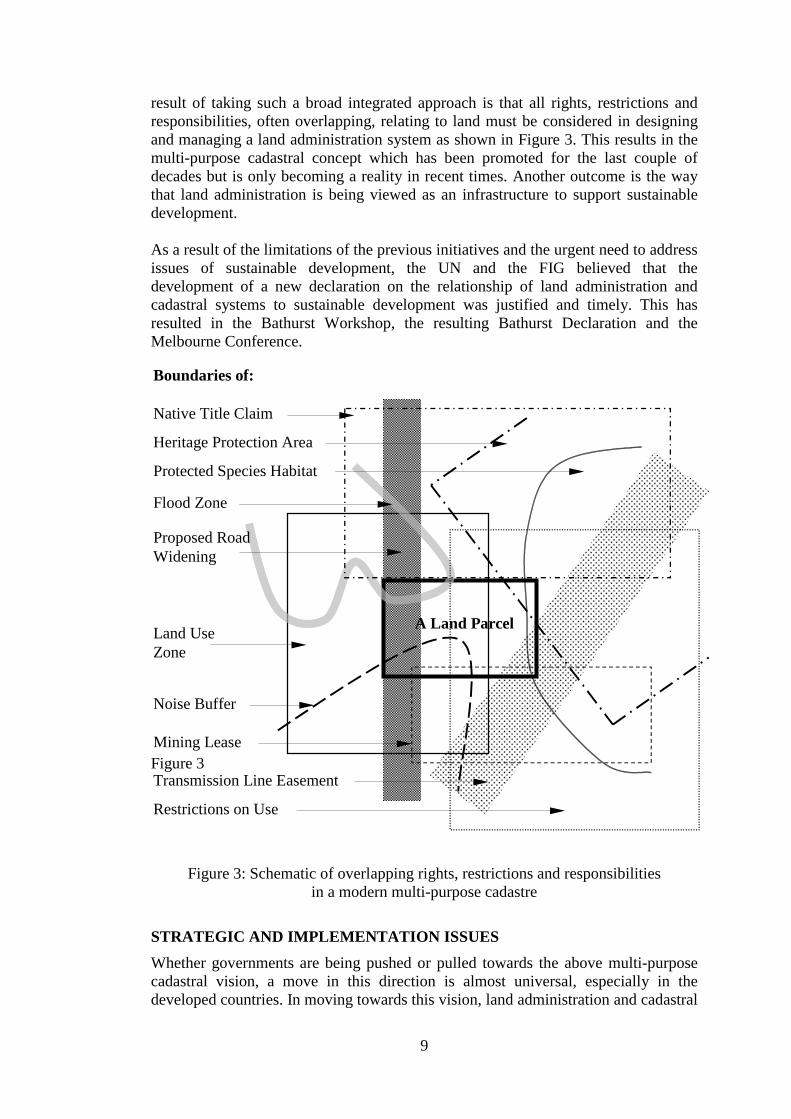
result of taking such a broad integrated approach is that all rights, restrictions andresponsibilities, often overlapping, relating to land must be considered in designingand managing a land administration system as shown in Figure 3. This results in themulti-purpose cadastral concept which has been promoted for the last couple ofdecades but is only becoming a reality in recent times. Another outcome is the waythat land administration is being viewed as an infrastructure to support sustainabledevelopment.
As a result of the limitations of the previous initiatives and the urgent need to addressissues of sustainable development, the UN and the FIG believed that thedevelopment of a new declaration on the relationship of land administration andcadastral systems to sustainable development was justified and timely. This hasresulted in the Bathurst Workshop, the resulting Bathurst Declaration and theMelbourne Conference.
Figure 3
Figure 3: Schematic of overlapping rights, restrictions and responsibilitiesin a modern multi-purpose cadastre
STRATEGIC AND IMPLEMENTATION ISSUESWhether governments are being pushed or pulled towards the above multi-purposecadastral vision, a move in this direction is almost universal, especially in thedeveloped countries. In moving towards this vision, land administration and cadastral
Native Title Claim
A Land Parcel
Flood Zone
Land UseZone
Noise Buffer
Transmission Line Easement
Heritage Protection Area
Protected Species Habitat
Mining Lease
Proposed RoadWidening
Restrictions on Use
Boundaries of:
10
Figure 4. The business-infrastructure model.
Business processGIS
GIS/SDI forbusiness
activities in anorganisation
Infrastructure GIS/SDI module
systems are being re-engineered as discussed in the framework described in Figure 2.This process highlights a range of strategic and implementation issues which shouldbe considered in developing future land administration systems, although not all willapply to every system. These issues include policy, technical, institutional,administrative and legal components, even though it is often difficult to categorisethem as one or another. The influence of these trends and changes are resulting innew rights, restrictions and responsibilities in land, new tenures, new processes andnew institutional structures.
New technologies have dictated and influenced many changes in the development ofland administration and cadastral systems, especially the information technologyadvances and the more specialised spatial information technologies. The GIStechnologies for data management, manipulation, analysis and integration arguablyhave had the greatest impact on the spatial information environment, although in thefuture the communication technologies such as the WWW are rapidly becoming thefocus of attention. These technologies are expected to be the norm for viewing,locating and using land related information in the years ahead.
Legislative reform appropriately follows policy development, technological advancesand institutional reform and should be a support process in re-engineering landadministration systems. Since legislation should simply be an expression of theimplementation of policy adopted at a political level, it does not warrantinvestigation in this paper, even though its importance in land administration reformis critical. Unfortunately legislation is used as an excuse to inhibit landadministration reform in some countries (UN, 1997).
Following are some of the land administration and cadastral trends and issues inwhich the authors and their colleagues are currently involved, which are part of orinfluence or result from the re-engineering process. The first issue is concerned withthe evolving concept of spatial data infrastructures (SDIs). The business-infrastructure relationship is followed by a discussion of the hierarchy of SDIs, theneed for partnerships in SDI development, the growing focus on national cadastraldata sets in national SDIs and the spatial hierarchy issue. These are then followed bythe difficulty of incorporating traditional or customary rights in “western” landadministration systems, the complexity of the spatial component of cadastral systemsand the impact of the WWW on land administration systems. Lastly issues such asevolving government, professional and educational institutions and benchmarkingland administration systems are considered.
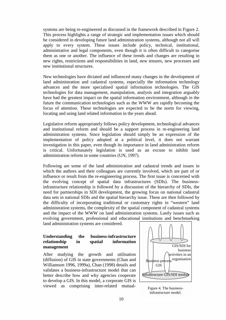
Understanding the business-infrastructurerelationship in spatial informationmanagementAfter studying the growth and utilisation(diffusion) of GIS in state governments (Chan andWilliamson 1996, 1999a), Chan (1998) details andvalidates a business-infrastructure model that canbetter describe how and why agencies cooperateto develop a GIS. In this model, a corporate GIS isviewed as comprising inter-related mutual-

11
supporting multi-levelled modules of business process GIS and infrastructure GIS inthe context of the business/production activities of the organisation (Figure 4).
Based on this model, an SDI is disaggregated into a collection of modules ofhierarchical infrastructure GIS (the shaded ovals). The business process GISrepresents the GIS capabilities developed by the users (the clear ovals) that rely onthe SDI modules to deliver the products and services needed by the geospatialinformation industry. This GIS may, in turn, nurture the development of new SDImodules, and link different SDI modules together.
The inherent relationships between the infrastructure and the business process in thebusiness-infrastructure model provide a broad framework for any land administrationsystem development.
The changing nature of spatial data infrastructuresCurrent spatial data infrastructures (SDIs) are in reality a sophisticated version of thesystems that most developed nations have had for over 50 years. They are becomingan important component of any land administration infrastructure. Anotherdevelopment is the recognition that SDIs comprise people, a clearinghouse/accessnetwork, technical standards, an institutional framework and framework data. Thespatial data infrastructures of the past were designed and driven primarily by theproviders of the infrastructure. The lastdecade has seen rapidly expandingnumbers of users of spatial data, whichare resulting in a proliferation of spatialbusiness systems. These are nowinfluencing and demanding specificcharacteristics from SDIs. With therapidly changing spatial informationenvironment and the impact of suchtechnologies as the WWW, GPS, highresolution satellite imagery,communication technologies andsophisticated decision support systems based on GIS technologies, these spatial datainfrastructures will continue to change and develop.
In exploring such changes it is useful to recognise that SDIs are now often beinggrouped into a hierarchy (Figure 5) comprising six levels of SDIs, namely, global,regional, national, state (also called provincial), local and corporate (Chan andWilliamson 1999b). Ideally with compatible sets of SDIs, users working on issues ata higher level in the hierarchy can draw on data from SDIs in all other levels lower inthe hierarchy (Rajabifard, et al. 1999). Again any jurisdiction embarking on the re-engineering of land administration systems should take this hierarchical view of SDIsinto account.
Developing partnershipsPartnership refers to the association of two or more people as partners in the carryingon of a business with shared risks and profits. In this context it is generally
global
regional
national
state
local
corporate
Figure 5. Hierarchy of SDIs

12
recognised that no one agency can develop a National SDI (NSDI) with the resultthat different national SDI coordinating agencies are encouraging NSDI developmentthrough partnerships (Federal Geographic Data Committee 1997, AUSLIG 1999). Inthe USA alone, over 50 major partnership initiatives have been established since1995 on a thematic, state wide and regional basis. States like Victoria in Australiahave recently achieved considerable success in developing strong partnerships withlocal government in providing the State’s SDI. These SDIs, and particularly thecadastral component, are an essential component of future land administrationinfrastructures.
Australia has accumulated significant experience with the development of thecadastral component of its NSDI through a wide range of partnerships betweenpublic bodies and those between a public body and a private corporation (Mooneyand Grant 1997, Williamson et al. 1998). Some are successful and some are not, butall are useful in understanding how partnerships can be better utilised in cadastraland NSDI development. The issues involved in establishing partnerships includestandards, cost sharing, privacy, copyright and inter-state/inter-person rivalry.However, the Australian experience also suggests that where there is a need, there isalways a solution. It is expected that the determining factors in an on-going researchproject into partnerships in SDI development will be the type of partnership, theobjective, the business driver, organisation settings of the partners and leadership byvisionary managers.
National cadastral systemsA move to create national cadastral systems in countries which are federations ofstates and territories raises many issues. The example of the development of thePublic Sector Mapping Agencies (PSMA) national data set in Australia, basedprimarily on state and territory DCDBs, together with the commitment to a nationalcompetition policy, has raised the concept of national cadastral data sets. Suchnational cadastral data sets are key components of any future national landadministration infrastructure. However it must be remembered that each state isresponsible under the Australian Constitution for land and land administration, likemany other countries which are federations, which results in each state and territoryhaving slightly different land administration and cadastral systems.
One of the differences between the jurisdictions is that different states define parcelboundaries differently. In some states cadastral boundaries can move while in othersthey cannot. The result is that the concept of a land parcel in the different Australianjurisdictions is different. The major difference is that some jurisdictions permitadverse possession as to part of a parcel and some do not (this means in somejurisdictions a boundary may have moved and is not shown on the digital cadastralmap). This difference can also significantly affect the operation of the local landmarket.
At one level it can be stated in Australia that while all the states permit adversepossession and the two Territories do not, the differing requirements within eachstate's own scheme must be recognised. For example the State of South Australiaonly permits adverse possession where registered land has been abandoned orperhaps informally transferred by the registered proprietor, and the registered
13
proprietor does not object to the proposed registration of the occupier as the newregistered proprietor. If a focus is taken on adverse possession of part of a parcel, asituation which can affect the location of the boundary between adjoining parcels, adifferent conclusion may result. While the State of New South Wales permits adversepossession it does not allow adverse possession of less than a whole parcel. TheState of Victoria on the other hand does, which is in line with traditional adversepossession of land not within the Torrens registration scheme (Park et al.1998, Parkand Williamson 1999a and 1999b).
A single national cadastre in Australia is technically possible as illustrated by thePSMA mapping base (Mooney and Grant 1997) mentioned previously. The positiveresponse from the spatial information industry towards such a product has beenfavourable, suggesting that a single national cadastre is also desirable. However apossible difficulty is the different approach of each jurisdiction to adverse possessionof registered title land, and particularly to part parcel. If Australia decides to adoptcommon cadastral legislation, it appears that this "possible difficulty" could prove tobe a stumbling block in moving towards a national cadastral system. Again thishighlights the importance of a broader and more national view in undertaking the re-engineering of State and Territory land administration systems. In the past suchchanges were only ever considered within a single jurisdictional focus, however thatparochial view may require modification.
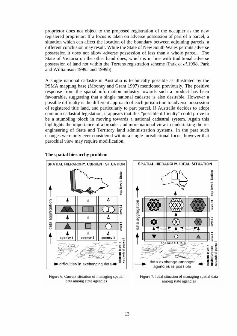
The spatial hierarchy problem
Figure 6. Current situation of managing spatialdata among state agencies
Figure 7. Ideal situation of managing spatial dataamong state agencies

14
With the advent of spatial business systems demanding more from spatial datainfrastructures and the broader land administration and cadastral systems, problemswith the “spatial hierarchy” are becoming an issue. The spatial hierarchy problemrefers to the difficulties in exchanging, aggregating and analysing different data setsbased on non-coterminous boundaries, as illustrated in Figures 6 and 7 (Eagleson, etal. 1999).
Figure 6 illustrates the current situation where each agency collects and aggregatesdata based on its own hierarchically structured boundaries. The bottom layer is theland parcel or cadastral map, a core component of a land administrationinfrastructure. Land parcels are recognised as indivisible units. This is commonpractice in most countries. As a result, data aggregation is possible within eachagency but presents difficulties to the sharing of data between various agencies.
Research is being undertaken in Australia to examine trends in such organisations asthe Australian Bureau of Statistics (ABS), health and social security departments,and Australia Post to explore the use of Hierarchical Spatial Reasoning (HSR) inassisting in the spatial hierarchy problem. Such an approach has been applied indifferent applications such as “way finding” for navigation systems (Car, 1997). Theproperties inherent in HSR theory make it suitable as the base for a re-organisation ofspatial units under a common hierarchy. This research aims to apply the principles ofHSR theory to the re-organisation of spatial boundaries. Figure 7 shows a modelwhere all agencies share a common structure that enables better analyses usingdifferent data sets. By applying HSR to this problem, GIS will hopefully improve itscapacity for data integration (one of the items on the agenda of GIS institutions suchas the National Center for Geographic Information and Analysis (NCGIA) and theUniversity Consortium for Geographic Information Science (UCGIS)).
Recognising that land administration systems are now providing an infrastructure fora much wider range of uses, any re-engineering of such systems should take thespatial hierarchy problem into account.
Integration of customary and traditional tenures into “western” landadministration systemsThe inclusion of indigenous interests in land has been recognised by the UnitedNations in Agenda 21 as important for maintaining and developing a landinformation system in support of sustainable development. This is a world trend withindigenous interests in land having been recognised and integrated to some degreewithin mainstream land administration systems, such as those in New Zealand, USA,Fiji, Papua New Guinea, and more notably the establishment of the NunavutTerritory in Canada by the Inuit people.
On the one hand the integration of diverse land tenures into one comprehensive landadministration system is essential and inevitable, however it presents manydifficulties which have been highlighted around the world. On the other hand thenew spatial information technologies and the emerging multi-purpose cadastralsystems offer much potential in assisting in solving the inevitable problems indeveloping the land administration infrastructures that jurisdictions which have toaddress this issue, will need over the next 10 years.
15
From an Australian perspective for example, the recent results from the High Court’sdecision concerning Mabo and Wik, and the inception and implementation of theNative Title Act 1993 highlight the issue. These decisions are driving the integrationof two vastly different land tenure systems in Australia, namely traditionalAboriginal land tenure and the Australian Torrens system. The amalgamation mustresult in future modern multi-purpose cadastres in Australia being able to includenative title interests while maintaining cultural integrity (Brazenor et al. 1999). Thetensions inherent in amalgamating two different land tenure systems such as thesepresent a challenge to any country in this situation which is embarking on landadministration reform.
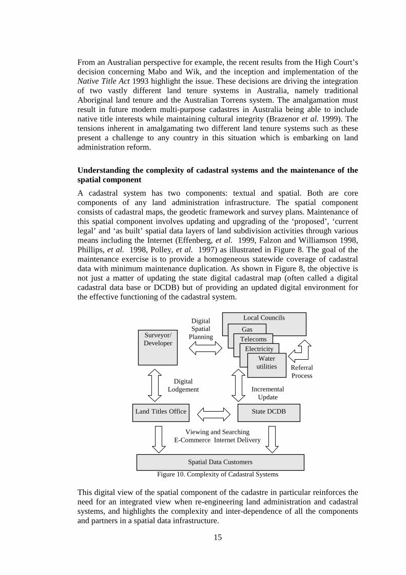
Understanding the complexity of cadastral systems and the maintenance of thespatial componentA cadastral system has two components: textual and spatial. Both are corecomponents of any land administration infrastructure. The spatial componentconsists of cadastral maps, the geodetic framework and survey plans. Maintenance ofthis spatial component involves updating and upgrading of the ‘proposed’, ‘currentlegal’ and ‘as built’ spatial data layers of land subdivision activities through variousmeans including the Internet (Effenberg, et al. 1999, Falzon and Williamson 1998,Phillips, et al. 1998, Polley, et al. 1997) as illustrated in Figure 8. The goal of themaintenance exercise is to provide a homogeneous statewide coverage of cadastraldata with minimum maintenance duplication. As shown in Figure 8, the objective isnot just a matter of updating the state digital cadastral map (often called a digitalcadastral data base or DCDB) but of providing an updated digital environment forthe effective functioning of the cadastral system.
Figure 10. Complexity of Cadastral Systems
This digital view of the spatial component of the cadastre in particular reinforces theneed for an integrated view when re-engineering land administration and cadastralsystems, and highlights the complexity and inter-dependence of all the componentsand partners in a spatial data infrastructure.
Local Councils
GasTelecoms
Land Titles Office State DCDB
Spatial Data Customers
Surveyor/Developer
ElectricityWater
utilities
DigitalSpatial
Planning
ReferralProcess
DigitalLodgement Incremental
Update
Viewing and SearchingE-Commerce Internet Delivery
16
Impact of the WWW and communications technologiesThe WWW and communication technologies are having a major impact on theoperation of land administration and cadastral systems. The use of GIS in landadministration over the years, in both the natural resources and parcel based areas,has resulted in the proliferation of many large distributed spatial databases. Suchspatial databases require efficient means of data management and access tools thatintelligently guide users to the data. Metadata (data about data) and metadata enginesare examples of intelligent spatial access tools, areas where there is considerableresearch being undertaken. Metadata provides users with information about the dataprior to retrieving and using the data. A Metadata engine can use the metadata forsearching and retrieving datasets from across the WWW (Phillips et al, 1998). TheWWW is also often viewed as storage banks where spatial information can be storedand retrieved locally by Internet users. A prototype developed by Polley uses Javaand the Computer Gateway Interface (CGI) language to facilitate a two-way flow ofspatial data through the WWW (Polley, 1999).
The WWW is now seen as an alternative to delivering cadastral information frompublic bodies to the public. In fact some land administration organisations are seeingtheir whole delivery strategy based on the WWW. WWW servers and the emergenceof Map Servers also facilitate the move towards the realisation of the multi-purposecadastre concept described over 20 years ago and more recently in the BogorDeclaration on Cadastral Reform and Cadastre 2014. However it is only now, due tothe technology, that the vision is becoming a reality.
Together with distributed databases, the WWW and Map Servers, a multi-purposecadastre is expected to allow government agencies to overlay cadastral maps, titleregisters, planning and other vital land resources live and interactively in order toshow the complete legal situation of the land to Internet users across the world(Majid et al,1999). In other words it is becoming possible to identify all rights,restrictions and responsibilities relating to land over the WWW. No doubt theWWW, together with advanced communication and information technologies, willcontinue to be one of the drivers for the future development of land administrationinfrastructures.
Evolving government institutionsLand administration and cadastral systems have continued to undergo re-engineeringover the last 20 years in many developed countries and particularly during the lastdecade. As a result of the micro-economic reform driver, many governments aremoving away from service delivery to focus on directing and setting policy in theland administration and spatial information environment. This is resulting in thegrowth of a vibrant spatial information industry in some jurisdictions.
At the same time as governments recognise the importance of land administration tosustainable development, government institutions have continued to evolve. A trendhas been the amalgamation of all the land related information organisations into one

17
department, group or unit. A good example is Land Victoria in the Government ofVictoria, Australia, but examples can be found world-wide.
An important development has been the emphasis in spatial information developmentat a national level in countries like Australia which are federations of states. In thepast the only organisation with the ability to provide national spatial data was theAustralian Federal Government. However as a result of its mandate, the FederalGovernment tended to focus on small-scale spatial data. With the growth of mediumand large-scale digital data at a State and Territory level in Australia, usually basedon the cadastre, users are demanding access to this data as an aggregated product at anational level. This has seen the growth of the previously mentioned Public SectorMapping Agencies (PSMA) (Mooney and Grant, 1997), as an excellent example ofthe partnership concept in Australia, to provide these products.
Another outcome of these changing institutions has been a growing partnershipbetween academic institutions and both government and the private sectors. Withuniversities also having been significantly affected by micro-economic reformpolicies resulting in reduced government funding, universities are now providingmuch of the research and development to government in the broad landadministration, cadastral and spatial data infrastructure areas, research which waspreviously undertaken in-house by government.
As land administration systems take on a more multi-purpose role the necessity formore integrated government institutions and stronger partnerships will increase.
Education and Professional structuresThe land administration and spatial information revolution has influenced relatededucation and professional structures in countries such as Australia over the lastdecade or so. These influences and resulting trends are relevant considerations whendeveloping new land administration and cadastral systems. Professions such assurveying continue to evolve to accommodate the spatial information revolution,while endeavoring to maintain traditional services.
At the university level the impact on surveying has been significant. The surveyingdiscipline has been transformed over the last decade. We have seen the adoption inAustralia and internationally of the geomatics concept where the focus of thediscipline is to design, build and manage the spatial dimension of the natural andbuilt environment. Several programs like those at the Universities of Melbourne andNew South Wales in Australia have become accredited engineering degrees.
At a professional level there have been ongoing discussions in several countries foran amalgamation of the spatial professions into one spatial information body.
An interesting development in Australia is the joint creation of a National SpatialAccreditation Authority by the spatial information industry and professional bodies.This is being coordinated by The Institution of Surveyors, Australia Inc. Such amove is considered essential in a de-regulated environment where traditional bodieslike State and Territory Boards of Surveyors in Australia have come under threat as a
18
result of a national competition policy. At the same time as these developments areoccurring, the whole question of the statutory control of spatial data is under review.
These issues should be considered when undertaking reform of land administrationand cadastral systems.
Benchmarking or how does a government know if it has a good landadministration system?As governments are becoming cost conscious and as management practices such asquality assurance and international best practice are impacting on all governmentservices, governments are questioning the efficiency of their land administration andcadastral systems to a greater extent. Simply put, how does a government orjurisdiction know if it has an efficient and effective land administration and cadastralsystem?
As a result of these trends, there has been research into the approaches andtechniques in evaluating the success of these systems. On the one level there hasbeen a lot of work in developing guidelines as to what constitutes a good system orwhat are the components of a good system. This has included the FIG Statement onthe Cadastre, the UNECE MOLA Land Administration Guidelines, the BogorDeclaration on Cadastral Reform and the FIG Cadastre 2014 vision as examples.However none of these documents provided advice on how to evaluate theperformance of a system.
While there is still no definitive approach to evaluating land administration andcadastral systems, there has been some work undertaken which is useful.
The first is the work by Commission 7 of the FIG which is responsible for cadastreand land management. Over the period 1994-98 the Commission undertook aninternational benchmarking exercise of 53 countries or jurisdictions world wide(Steudler et al., 1997). This approach was adopted as the best way to evaluate theperformance of cadastral systems. The study collected economic and statisticalindicators about the size, activity and efficiency of each cadastral system so that anattempt could be made to crudely standardise the data so that it could be compared.The four-year exercise proved to be problematic since it was difficult to standardisemany of the definitions and processes. However after much effort, internationalgoodwill and collaboration some useful data was produced which is still proving ofbenefit to countries and jurisdictions for evaluating and improving their systems.
Another approach has been explored by Williamson and Fourie (1998) where theyadopted rigorous case study methodologies from the social sciences to cadastralreform. Again while this approach does not specifically provide an approach todetermining the performance of systems, it does provide a structured approach toevaluating cadastral systems.
Finally the work of Dale (1999) on developing a process to determine theperformance of land markets in countries undergoing transition in Eastern andCentral Europe is also useful. He has developed a land market model incorporatingpolicy, legal and financial components. Within this framework a qualitative scoring
19
system is applied, with the ability to normalise the results. The result is a process tocompare the development or efficiency of a land administration or cadastral systemfrom one country to another.
CONCLUSIONIn overviewing trends and issues in land administration and cadastral systems, twointer-connected papers have been prepared. The first by Ting and Williamson (1999)describes the humankind-land relationship and the global drivers which areinfluencing present land administration reforms. It set the scene for this paper whichhas attempted to look at the issues in re-engineering current land administration andcadastral systems to better meet the needs of the next millennium. The need for avision based on a broader and more integrated approach is argued. In order forcountries or jurisdictions to work towards such a vision a model for re-engineeringland administration systems is proposed. The components of the framework are usedto review issues and strategies based on the experience of the authors and theircolleagues.
In discussing land administration and cadastral reform the paper has described theprocess leading to the Bathurst Workshop and Melbourne Conference on land tenureand cadastral infrastructures to support sustainable development. It outlines previouswork by the UN and the FIG which is used as a basis for the workshop andconference. The two connected papers have attempted to provide a justification forthe framework for the UN-FIG Declaration on Land Tenure and CadastralInfrastructures for Sustainable Development as set out below:
• A future land administration and cadastral vision• The dynamic relationship of humankind to land• The role of land in sustainable development• Tenure systems and land administration• The interface between land markets, land registration, planning and valuation• Food, water and land• Re-engineering cadastral systems• Recommendations for implementation
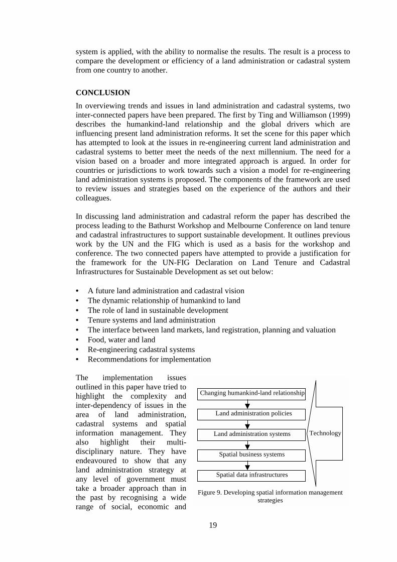
The implementation issuesoutlined in this paper have tried tohighlight the complexity andinter-dependency of issues in thearea of land administration,cadastral systems and spatialinformation management. Theyalso highlight their multi-disciplinary nature. They haveendeavoured to show that anyland administration strategy atany level of government musttake a broader approach than inthe past by recognising a widerange of social, economic and
Changing humankind-land relationship
Land administration policies
Land administration systems
Spatial business systems
Spatial data infrastructures
Technology
Figure 9. Developing spatial information managementstrategies
20
land related issues. A key outcome of such strategies is the development of landadministration infrastructures and spatial information management strategies.
The development of these spatial information management strategies requires anunderstanding of the relationship between the changing humankind-land relationship,land administration policies, land administration systems, spatial business systemsand spatial data infrastructures, while recognising the impact of technology acrossthese dimensions (Figure 9). In this context, spatial data infrastructures will evolve toaccommodate the business needs of land administration decision support systems andmulti-purpose cadastres. An emphasis on business needs as distinct frominfrastructure needs of spatial information will see a re-engineering of current SDIsas key components of future land administration systems.
In summary, sustainable development will be the focus for the changing humankind-land relationship into the next millennium. This will demand sophisticated landadministration infrastructures in order to support the necessary decision-making.These in turn will require support from more generic information technologiesintegrated with spatial information technologies that can process and package datathat is of sufficient quality, accuracy, relevance and inter-operability to the decision-makers. Herein lies the challenge that needs to be tackled in developing the nextgeneration of land administration systems.
ACKNOWLDEGEMENTThe authors gratefully acknowledge the support of Land Victoria (LV) of theVictorian Government, the Land Information Centre (LIC) of the New South WalesGovernment, the Australian Surveying and Land Information Group (AUSLIG) ofthe Commonwealth Government and the Australian Research Council (ARC) (GrantsC19700324 and C49930403) in supporting the research mentioned in the paper. Theauthors also acknowledge the assistance provided by their research colleagues DrFrancisco Escobar, Dr Tai On Chan, Wolfgang Effenberg, Malcolm Park, AbbasRajabifard, Paul Harcombe, Clare Brazenor, Serryn Eagleson and Sam Majid(http://www.geom.unimelb.edu.au/research/SDI_research/) at the Department ofGeomatics, the University of Melbourne in the preparation of the paper. However,the views expressed in the paper are those of the authors and do not necessarilyreflect the views of LV, LIC, AUSLIG or ARC.
REFERENCESAUSLIG, (1999) Webpage on Australian Spatial Data Infrastructure Partnerships Program. Accessed1 July 1999. <http://www.auslig.gov.au/pipc/asdi/part.htm>.
Brazenor, C., Ogleby, C.L. and Williamson, I.P. (1999) The Spatial Dimension of Aboriginal LandTenure. To be presented at 6th South East Asian Surveyors Congress, Fremantle, 1-6 November 1999.
Car, A., (1997) Hierarchical Spatial Reasoning: Theoretical Consideration and its Application toModeling Wayfinding. PhD thesis, Technical University, Vienna.
Chan, T. O., (1998) The Dynamics of Diffusion of Corporate GIS. PhD thesis , The University ofMelbourne.
Chan, T. O. and Williamson, I. P., (1996) A model of the decision process for GIS adoption anddiffusion in a government environment. In Proceedings of URISA '96, (Utah: URISA) pp. 247-260.
Chan, T. O. and Williamson, I. P., (1999a) The different identities of GIS and GIS diffusion.International Journal of Geographical Information Science, 13(3), 267-281.
21
Chan, T. O., and Williamson, I. P. (1999b) Spatial data infrastructure management: lessons fromcorporate GIS development. Paper presented at AURISA 99, Blue Mountain, NSW, 22-26 November,10 pages.
Dale, P.F. (1999) Cadastral and land administration systems in countries in transition. Lecture to theDepartment of Geomatics, University of Melbourne. Accessed 27 August, 1999<http://sunspot.sli.unimelb.edu.au/subjects/451/418/lecture10PPT/ppframe.htm>
Eagleson, S., Escobar, F., and Williamson, I. P., (1999) Spatial Hierarchical Reasoning Applied toAdministration Boundary Design Using GIS. To be presented at 6th South East Asian SurveyorsCongress, Fremantle, 1-6 November 1999.
Effenberg, W. W., Enemark, S. and Williamson, I. P. (1999) Framework for Discussion of DigitalSpatial Data Flow within Cadastral Systems. Australian Surveyor, 44(1).
Falzon, K. and Williamson, I. P. (1998) Digital Lodgement of Cadastral Survey Data in Victoria.Proceedings of the 39th Australian Surveyors Congress, Launceston, Tasmania, 8-13 November 1998
Federal Geographic Data Committee (1997) A Strategy for the NSDI. Federal Geographic DataCommittee, Reston, VA, 25 March, 1999 <http://www.fgdc.gov/nsdi/strategy/strategy.html>.
FIG (1995) Statement on the Cadastre. International Federation of Surveyors. WWW accessed 5thSeptember, 1999 <http://www.fig7.org.uk/cadastre/statement_on_cadastre.html>
Kaufmann, J. (1998) 'Cadastre 2014' – Report of Commission 7 Working Group 7.1, ModernCadastres. Congress Proceedings, Commission 7, FIG XXI FIG Congress, Brighton 1998. WWWaccessed 5th September, 1999 <http://www.fig7.org.uk/Brighton98/proceedings.html>
Kaufmann, J. and Steudler, D. (1998) Cadastre 2014: A Vision for a Future Cadastral System(Rheinfall, Switzerland: FIG). WWW accessed 5th September, 1999 < http://www.swisstopo.ch/fig-wg71/Docs/Cad2014index.htm>
Majid, S. and Williamson, I. P. (1999) Cadastral Systems on the World Wide Web - A Multi-PurposeVision. Paper presented at AURISA 99, Blue Mountain, NSW, 22-26 November, 9 pages.
MOLA (1999) Land Administration Guidelines. Meeting of Officials on Land Administration, UNEconomic Commission for Europe. ECE/HBP/96 Sales No. E.96.II.E.7, ISBN 92-1-116644-6. WWWaccessed 5th September, 1999 < http://www.sigov.si/mola/Preview/html/projects.html#nas1>
Mooney, J. D. and Grant, D. M. (1997) The Australian Spatial Data Infrastructure. In Framework ofthe World, edited by D. Rhind. (Cambridge: GeoInformation International), pp. 187-201.
Park, M., Ting, L. and Williamson, I.P. (1998) Adverse possession of Torrens land. 72(11) LawInstitute Journal 77
Park, M. and Williamson, I.P. (1999a) Australian cadastres: the role of adverse possession of partparcels. The Australian Surveyor (forthcoming)
Park, M. and Williamson, I.P. (1999b) The effect of adverse possession to part on a future Australiancadastre. To be presented at 6th South East Asian Surveyors Congress, Fremantle, 1-6 November1999.
Phillips, A., Williamson, I. P., and Ezigbalike, I. C. (1998) The Importance of Metadata Engines inSpatial Data Infrastructures. Proceedings of AURISA '98, Perth, Western Australia, 23-27 November1998
Polley, I., Williamson, I. P., and Effenberg, W. W. (1997) Suitability of Internet Technologies forAccess, Transmission and Updating Digital Cadastral Databases on the Web. Proceedings of AURISA97, Christchurch, New Zealand, 17-21 November 1997
Polley, I. (1999) Facilitating the use of Cadastral Data Through the World Wide Web. MastersThesis,University of Melbourne, Melbourne, 124 pp.
Rajabifard, A., Chan, T. O., and Williamson, I. P. (1999) The Nature of Regional Spatial DataInfrastructures. Paper presented at AURISA 99, Blue Mountain, NSW, 22-26 November, 10 pages.
Steudler, D., Williamson, I.P., Kaufmann, J. and Grant D.M. (1997) Benchmarking CadastralSystems. The Australian Surveyor, 42(3), 87-106
Ting, L. and Williamson, I.P. (1999). The dynamic humankind-land relationship and its impact onland administration systems. Proceedings of the joint United Nations and FIG International
22
Conference on Land Tenure and Cadastral Infrastructures for Sustainable Development, Melbourne,24-27 October, 1999.
UN/FIG (1996) Bogor Declaration on Cadastral Reform. FIG Webpage accessed on July 30 1999.<http://www.sli.unimelb.edu.au/fig7/Bogor/BogorDeclaration.html>
UN (1997). Report of Meeting of the Ad hoc Group of Experts on Legislation for Surveying andMapping, New York, U.S.A., 6 June, 1997. UN reference DDSMS/SEM.97/2.
Williamson, I. P., Chan, T. O., and Effenberg, W. W. (1998) Development of spatial datainfrastructures - lessons learned from the Australian digital cadastral databases. Geomatica, 52(2),177-187.
Williamson, I.P. and Fourie, C. Using the Case Study Methodology for Cadastral Reform.GEOMATICA, Vol. 52, No. 3, 283-295 (1998).
Williamson, I.P., (1996) A Land Information Vision for Victoria, Report for Geographic Policy andCoordination, Victoria, 21p. WWW accessed on August 22 1999.http://www.sli.unimelb.edu.au/research/publications/IPW_publ.html
NOTE: Most of the articles by Williamson and his colleagues can be found at<http://www.geom.unimelb.edu.au/research/publications/IPW_publ.html>


