Download - Korean projects contributing to FUTURE
Korean projects contributing to FUTURE
S. Yoo, YS. Kang, SJ. Ju, K. Shin, KI. Chang

AICE COV
E
SOFE
Region Korean Projects relevant to FUTURE
Local Development of Port Environmental RiskAssessment Technology : Ship Ballast Water
Regional Impact Assessment of Climate Change on Marine Ecosystem in the Southern Sea of Korea
Regional Yellow Sea LME
Regional A pilot study on forecasting long-term ecosystem changes in the East sea
Regional EAST-1
Regional Monitoring of the impacts of Three-Gorges Dam on the East China Sea ecosystem
Regional Basis investigation of ecosystems of Korean Seas
Basin Ocean Climate Change: Analyses, Projections, Adaptation
Regional Climate Change and FisheriesClimate Change and Fisheries
Korean Projects relevant to FUTURE

Dynamic
Development of Port Environmental RiskAssessment Technology : Ship Ballast Water
■
Objectives
� Risk assessment of ballast waters discharged from foreign ships
■
Contents
� Protection marine coastal ecosystems from non-native species� Port and ship ballast water monitoring� Development of risk assessment program considering exemptions
Trading port (27)Coastal port

Dynamic
Ballast waterBiological monitoring
Information ofship cruise
PortSpatial
information
PortBiological monitoring
PortEnvironmental
monitoring
Reporting Form
Port risk management
system
k i m
WEB Server
Intake and discharge
of ballast water
KRISOG2 샘플링/분석G13 비상시추가조치
G7 면제위해도평가
Exchange of data
between adjacent nations
DBServer
Port Environmental Risk Assessment TechnologyPort Environmental Risk Assessment Technology
■
ApproachApproach
Assessment Assessment
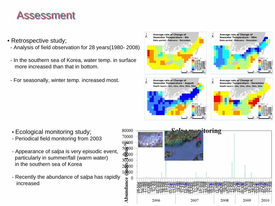
• Retrospective study;-
Analysis of field observation for 28 years(1980-
2008)
-
In the southern sea of Korea, water temp. in surface more increased than that in bottom.
-
For seasonally, winter temp. increased most.
• Ecological monitoring study; - Periodical field monitoring from 2003
- Appearance of salpa is very episodic event, particularly in summer/fall (warm water)in the southern sea of Korea
- Recently the abundance of salpa has rapidly increased
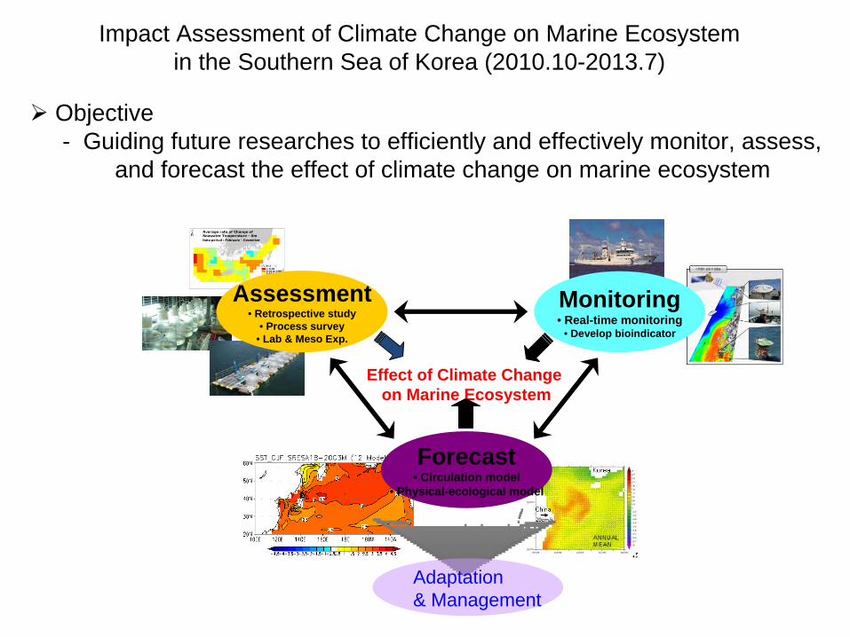
Impact Assessment of Climate Change on Marine Ecosystemin the Southern Sea of Korea (2010.10-2013.7)
Assessment• Retrospective study
• Process survey• Lab & Meso
Exp.
Effect of Climate Change on Marine Ecosystem
Monitoring• Real-time monitoring
• Develop bioindicator
Forecast• Circulation model
• Physical-ecological model
Adaptation & Management
Objective-
Guiding future researches to efficiently and effectively monitor, assess, and forecast the effect of climate change on marine ecosystem
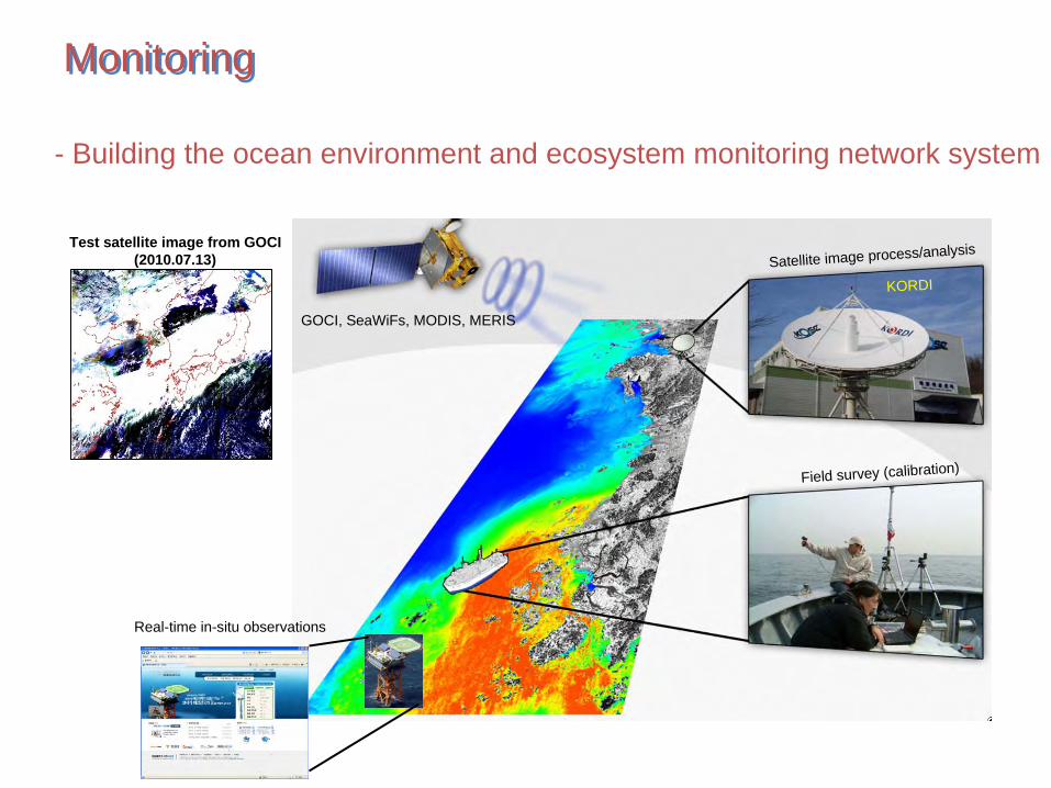
Test satellite image from GOCI(2010.07.13)
GOCI, SeaWiFs, MODIS, MERIS
Satellite image process/analysis
Field survey (calibration)
Real-time in-situ observations
KORDI
MonitoringMonitoring
- Building the ocean environment and ecosystem monitoring network
system
ForecastingForecasting
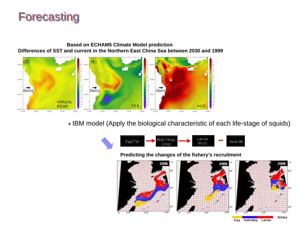
Based on ECHAM5 Climate Model predictionDifferences of SST and current in the Northern East China Sea between 2030 and 1999
+ IBM model (Apply the biological characteristic of each life-stage of squids)
Predicting the changes of the fishery’s recruitment
July Aug. Sep.
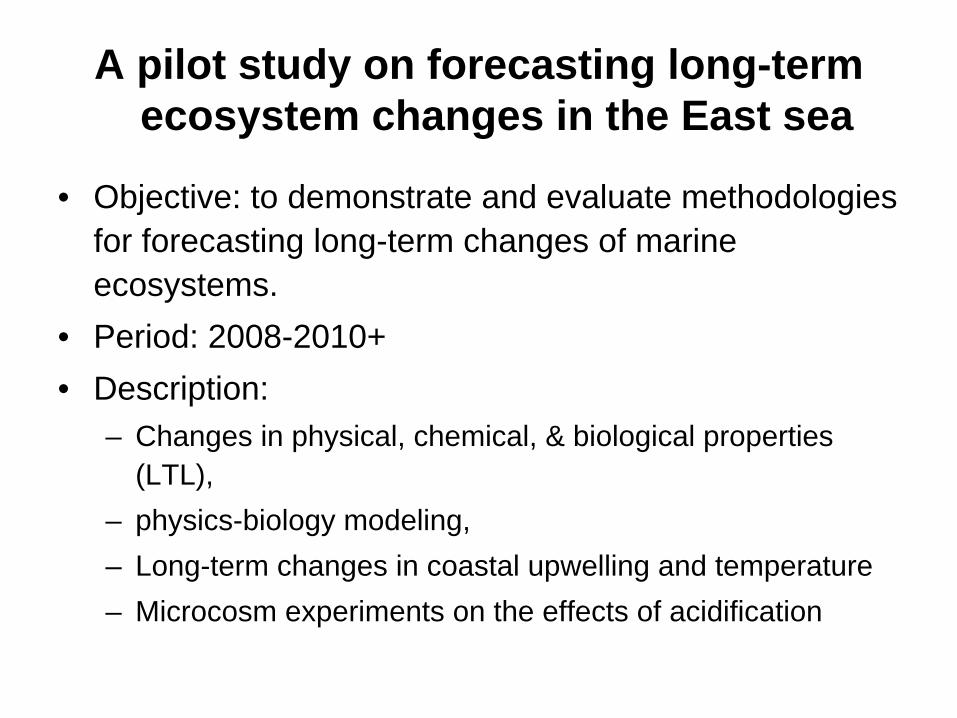
A pilot study on forecasting long-term ecosystem changes in the East sea
•
Objective: to demonstrate and evaluate methodologies for forecasting long-term changes of marine ecosystems.
•
Period: 2008-2010+•
Description: –
Changes in physical, chemical, & biological properties (LTL),
–
physics-biology modeling, –
Long-term changes in coastal upwelling and temperature
–
Microcosm experiments on the effects of acidification

Duration: 2006-2010 (1st phase); 2011-2015 (2nd phase) Funding: Ministry of Land, Transport and Maritime AffairsParticipating institutions: 5 universities, 2 national institutes
OBJECTIVES• To identify and quantify the dynamic processes governing the variability of
and the interaction between circulation/material cycle and the ecosystem response on multiple timescales
•• To investigate the response of these processes to global changeTo investigate the response of these processes to global change•• To construct scientific background for management and sustainablTo construct scientific background for management and sustainable e
development of marine environmentsdevelopment of marine environments
Korea EAST-I Program
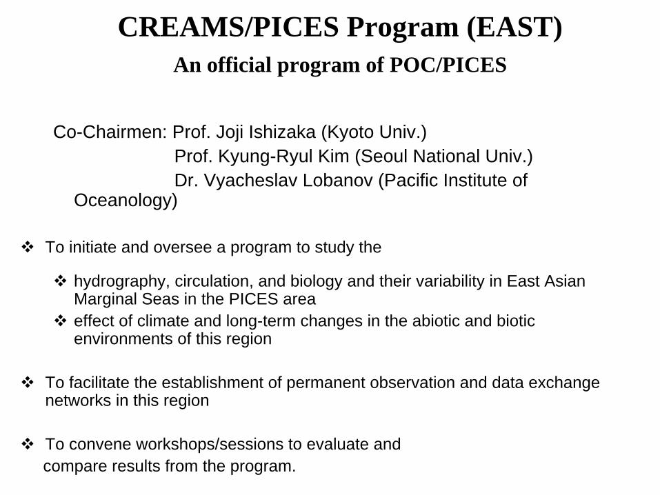
CREAMS/PICES Program (EAST)An official program of POC/PICES
Co-Chairmen: Prof. Joji
Ishizaka (Kyoto Univ.)Prof. Kyung-Ryul
Kim (Seoul National Univ.)Dr. Vyacheslav Lobanov (Pacific Institute of
Oceanology)
To initiate and oversee a program to study the
hydrography, circulation, and biology and their variability in East Asian Marginal Seas in the PICES area
effect of climate and long-term changes in the abiotic
and biotic environments of this region
To facilitate the establishment of permanent observation and data exchange networks in this region
To convene workshops/sessions to evaluate andcompare results from the program.

CREAMS/PICES EAST Program
CREAMS/PICESEAST
Korea EAST-I
PICES
International Advisory Panel
EDF
Synthesis & Modeling
EAST-I Development& Networking
Data Management
Satellite DataSupport
CarboEASTCarboEASTHydroEASTHydroEAST EcoEASTEcoEAST
Japan EAST-IRussia EAST-I
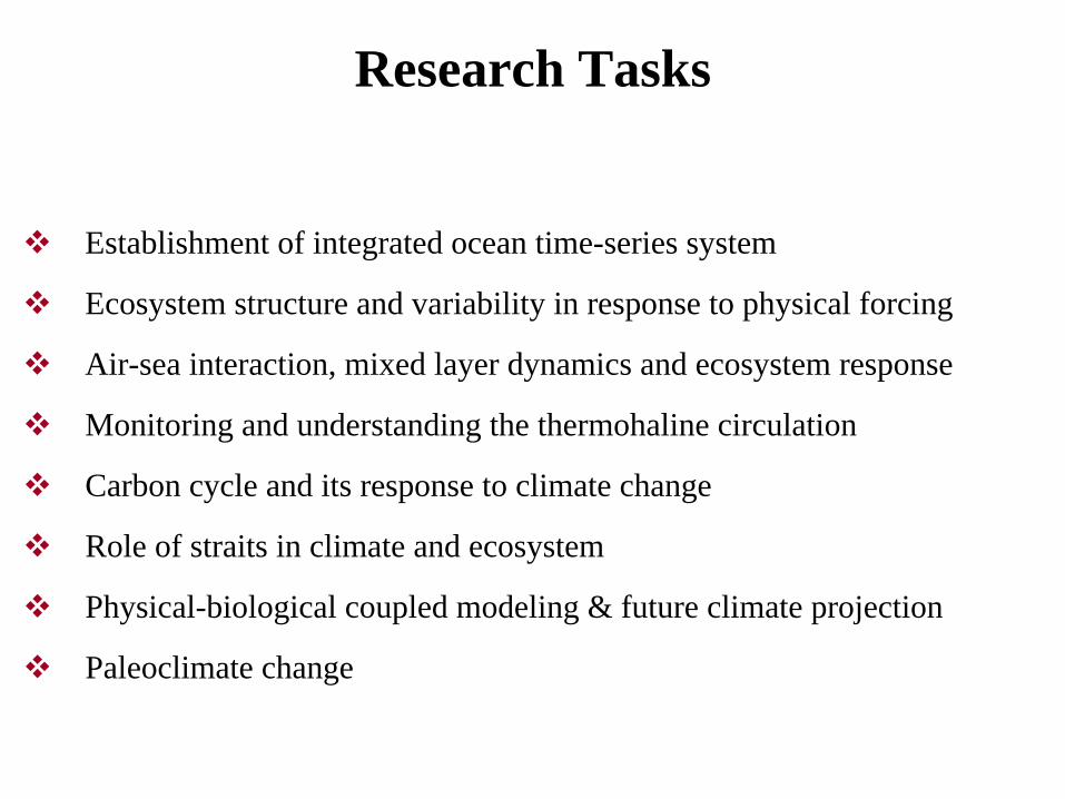
Research Tasks
Establishment of integrated ocean time-series system
Ecosystem structure and variability in response to physical forcing
Air-sea interaction, mixed layer dynamics and ecosystem response
Monitoring and understanding the thermohaline circulation
Carbon cycle and its response to climate change
Role of straits in climate and ecosystem
Physical-biological coupled modeling & future climate projection
Paleoclimate change

International Collaboration/Network
CREAMS/PICES International Advisory Panel Meeting
CREAMS/PICES Workshop/Summer School (2006.8, Busan)
Korea-Japan Joint Workshop (2008.2, Nagoya, Japan)
Second CREAMS/PICES Workshop on EAST-I (2008.7, Seoul)
The 15th PAMS Meeting (2009.4, Busan)
PICE International Summer School (2008, 7/2009.8, Seoul)
Journal of Marine Systems Special Issue (2009.9)
EAST-I Super Station
15
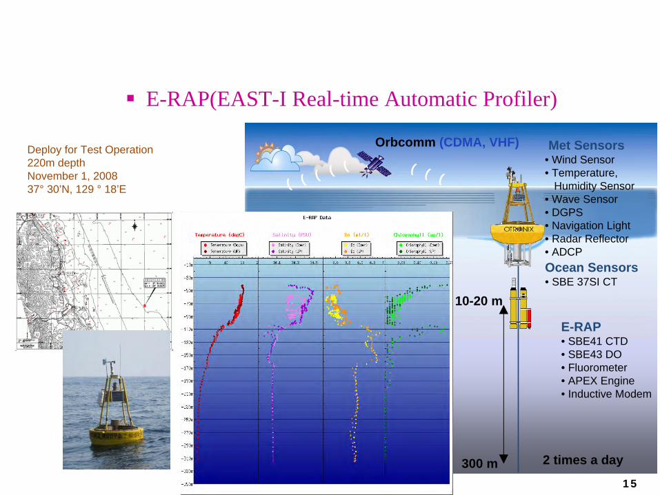
E-RAP(EAST-I Real-time Automatic Profiler)
Orbcomm (CDMA, VHF) Met Sensors• Wind Sensor•
Temperature,
Humidity Sensor• Wave Sensor• DGPS• Navigation Light• Radar Reflector• ADCP
E-RAP• SBE41 CTD• SBE43 DO• Fluorometer• APEX Engine• Inductive Modem
Ocean Sensors• SBE 37SI CT
10-20 m
300 m 2 times a day
) ) )) ) ) ) )
Deploy for Test Operation 220m depthNovember 1, 2008 37°
30’N, 129 °
18’E

Basin-wide Time-series Measurement
동해전역남-북관측 (한-러)
R/V Akademik Lavrentyev
인공위성자료활용
동해전역동-서관측 (한-일)
R/V Hakuho-Maru
월별기준선관측
망상
덕산
후정
무인자동관측
수중계류
실시간심해복합모니터링시스템
Super Station 운용
관할해역집중관측
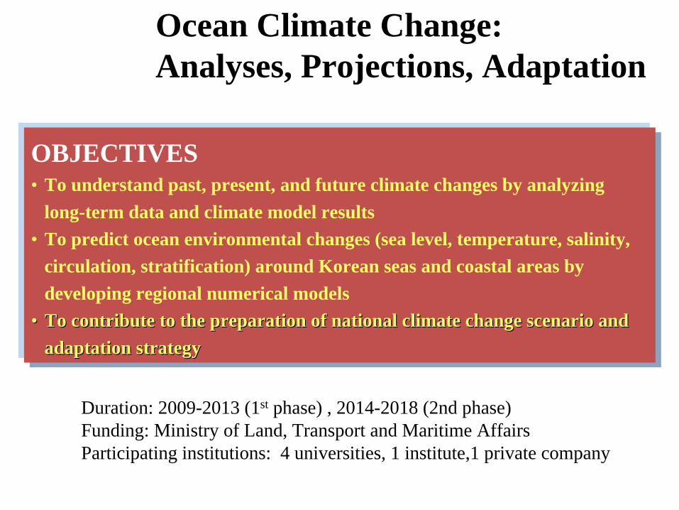
Duration: 2009-2013 (1st phase) , 2014-2018 (2nd phase)Funding: Ministry of Land, Transport and Maritime AffairsParticipating institutions: 4 universities, 1 institute,1 private company
OBJECTIVES• To understand past, present, and future climate changes by analyzing
long-term data and climate model results• To predict ocean environmental changes (sea level, temperature, salinity,
circulation, stratification) around Korean seas and coastal areas by developing regional numerical models
•• To contribute to the preparation of national climate change scenTo contribute to the preparation of national climate change scenario and ario and adaptation strategyadaptation strategy
Ocean Climate Change: Analyses, Projections, Adaptation
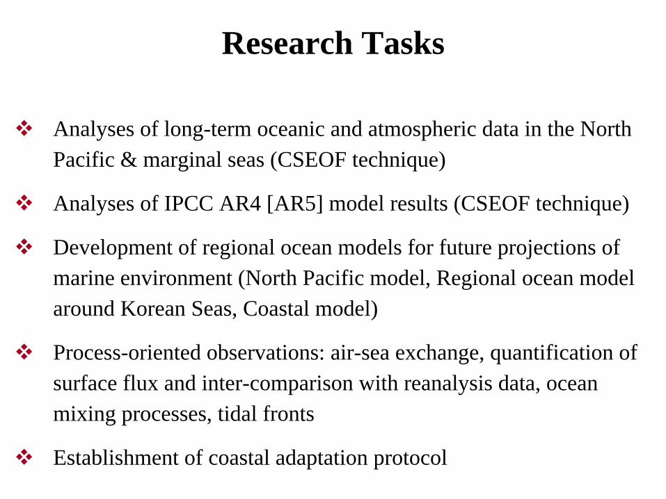
Research Tasks
Analyses of long-term oceanic and atmospheric data in the North Pacific & marginal seas (CSEOF technique)
Analyses of IPCC AR4 [AR5] model results (CSEOF technique)
Development of regional ocean models for future projections of marine environment (North Pacific model, Regional ocean model around Korean Seas, Coastal model)
Process-oriented observations: air-sea exchange, quantification of surface flux and inter-comparison with reanalysis data, ocean mixing processes, tidal fronts
Establishment of coastal adaptation protocol

115˚ 125˚ 135˚ 145˚ 155˚
Longitude
15˚
20˚
25˚
30˚
35˚
40˚
45˚
50˚
Latit
ude
East China Sea
Yellow Sea
CHINA
KOREA
East Sea
JAPAN
Changjiang River
Hanghe River
Northwest Pacific
Korea St.
Soya St.
Taiwan St.
Tsugaru St.
Horizontal resolutionsHorizontal resolutions
North Pacific Model 0.25North Pacific Model 0.25
Korean Seas Model 0.1Korean Seas Model 0.1
Regional Model Development

ROMS-based Regional Ocean Model

울
산
부
산
울
산
포
항
부
산
울
산
(1/36) Degree
(1/108) Degree
(1/324) Degree
Fine-Resolution Coastal Ocean Model

Climate Change and FisheriesClimate Change and Fisheries
I.
Period : 2010~2017II.
Purpose :
-
To establish scientific background for making fisheries strategy responded to climate change
-
To assess vulnerability and make policy of adaptation III. Approach
-
1st
step (2010~’12): Establishing a specific monitoring system and assessing the impact of climate change on fisheries
-
2nd
step (2013~’15): Developing a forecast system for changes of oceanographic condition and fisheries
-
3rd
step (2016~’17): Making strategies for adaptation and policy

• Sub-projects
– Changes of oceanography and fisheries responded to climate change
– Develop accurate forecast system for oceanographic condition and fisheries
– Establish the specific monitoring herb in the East Sea:
• Atmosphere-Oceanography Interaction
• Anomalous events in the coastal area
• Integrated monitoring for
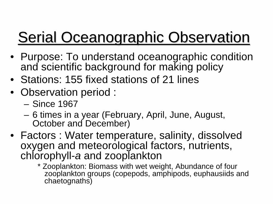
Serial Oceanographic ObservationSerial Oceanographic Observation•
Purpose: To understand oceanographic condition and scientific background for making policy
•
Stations: 155 fixed stations of 21 lines•
Observation period : –
Since 1967
–
6 times in a year (February, April, June, August, October and December)
•
Factors : Water temperature, salinity, dissolved oxygen and meteorological factors, nutrients, chlorophyll-a and zooplankton
* Zooplankton: Biomass with wet weight, Abundance of four zooplankton groups (copepods, amphipods, euphausiids
and chaetognaths)

<Location of the serial oceanographicobservation stations>
<Location of the coastal oceanographicobservation stations>

Monitoring Programs for Coastal Monitoring Programs for Coastal EnvironmentsEnvironments
•
Purpose: To understand coastal envrionment condition and scientific background for making
policy•
Stations: 108 stations
•
Observation period : –
Since 1997
–
4 times in a year (February, May, August and November)
•
Factors Water qualities Salinity, pH, DO, COD, TN, DIN, TP, SS, Cu, Pb, Zn
etc. Marine organisms Chrophyll-a and colon bacillus Sediment Sediment contents, COD, Cu, Pb
etc.
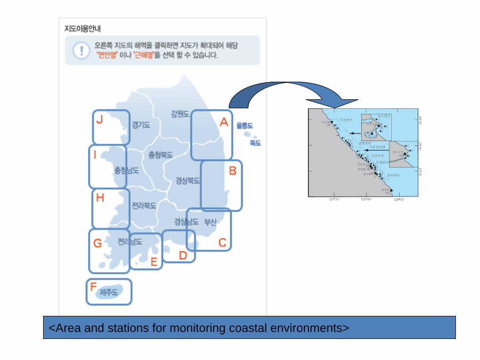
<Area and stations for monitoring coastal environments>
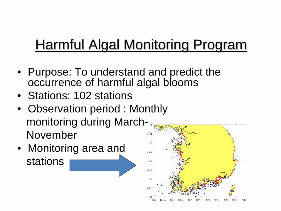
Harmful Algal Monitoring ProgramHarmful Algal Monitoring Program
•
Purpose: To understand and predict the occurrence of harmful algal blooms
•
Stations: 102 stations•
Observation period : Monthly monitoring during March-November
•
Monitoring area and stations
Proposed K-FUTURE Projects•
The responses of the East Sea Ecosystem to climate change: Monitoring of the north-south transects using sea gliders and other platforms will be conducted. How the circulation processes such as formation of the intermediate water are changing and how it will affect the biogeochemical cycles are the key issues.
•
Interactions in the coastal ecosystems. This theme corresponds with FUTURE/AICE and will attempt to assess the human impacts on the coastal ecosystems. It will also assess the feedback impact on human societies. This study will utilize ecological risk analysis, ecosystem statue assessment and socio-economic analysis among others.

• E
ND


