
Archaeoastronomy and Ancient Technologies 2016, 4(1), 150-168; http://aaatec.org/art/a_vl10
www.aaatec.org ISSN 2310-2144
Image of Inverted World Tree on the Stone Slab and
Vessels of the Bronze Age
Larisa N. Vodolazhskaya1, Pavel A. Larenok
2, Mikhail Yu. Nevsky
3
1 Southern Federal University (SFU), Rostov-on-Don, Russian Federation;
E-mails: [email protected], [email protected] 2 NP "Yuzharheologiya", Rostov-on-Don, Russian Federation; E-mail: [email protected] 3Southern Federal University (SFU), Rostov-on-Don, Russian Federation; E-mails:
Abstract
The article presents the results of the study of petroglyphs on a unique stone slab discovered near
the kurgan 1 of the kurgan field Varvarinsky I (Rostov Oblast, Russia). Analysis of features of the
location and style of petroglyph "tree" showed that the branches could determine semi-minor semiaxes
m of the "dial" ellipses of analemmatic sundials with semi-major axis M = 24.2 cm for medium and
high (northern) latitudes up to the North Pole and "tree" marks the direction to the North. The desire to
construct a tool with which it was possible to build a "dial" for analemmatic sundial for different
latitude up to the latitude of the North Pole could appear under the influence of the dominant
mythological ideas about sacred geography of the surrounding world in which the North is the World
Mountain, World Tree or the abode of the gods. In the article the authors conclude that the petroglyph
"tree" on Varvarinsky slab marks the direction to the North as a projection of the North Pole of the
world on the earth's surface, which simulates the slab. Petroglyph is an image of an inverted World
Tree, when viewed from the gnomon / man. The trunk of the Tree corresponds to the astronomical
world axis, and its branches symbolize the visible daily path of the Sun and, perhaps, the night paths
of stars across the sky at different latitudes. During the research was carried out a comparative analysis
of the petroglyph "tree" with images of the inverted tree on the Srubna vessels. According to the
analysis it was concluded that a mythical World Tree of Srubna population is likely to be a tree of pine
family. Sign of the inverted tree on the Srubna vessels has been interpreted by as a symbol of the
direction of the North and / or the north pole of the world; and accompanying signs were interpreted as
symbols of circumpolar stars and constellations (asterisms).
Keywords: stone slab with petroglyphs, inverted World Tree, sundial, vessels with signs, Srubna
culture, Varuna-Mitra, archaeoastronomy.
Introduction
In 2013 archaeologist A.V. Fayfert discovered the stone slab with petroglyphs in Sholokhov
district of Rostov Oblast (Russia) (Fig. 1). The slab was found in 30 m to the southeast of kurgan
1 of the kurgan field Varvarinsky I (49.5º N, 41.4º E). Kurgan has a height of 0.4 m at the
moment, and it is pulled on the North-South line. Plate weight around 70 kg. The second side of
slab does not contain petrogliphs [1, p. 27-28].

Archaeoastronomy and Ancient Technologies 2016, 4(1), 150-168 151
a
b
Figure 1. Kurgan field Varvarinsky I, kurgan 1 (neighborhood), a stone slab with
petroglyphs: a - photo of the slab1 (by A.D. Vodolazhskiy, 2014), b – drawing of the slab (by
L.N. Vodolazhskaya, 2015). Slab is worth perpendicular to the floor (the alignment was carried
out using plumb lines, slab supported by special fasteners located between the slab and the wall)
[2].
1 The photo was taken with the camera, Pentax K-50. For reduction of distortions the process of photographing
of vertically standing (checked by means of a plumb) slab produced at a distance about four meters. The lens of the
camera, directed perpendicular to slab surface, was opposite to its center. The resulting slab image occupied a small
part in the center of the frame. Location photometers monitored by building levels. The flash is not used.

Archaeoastronomy and Ancient Technologies 2016, 4(1), 150-168 152
An analysis of the petroglyphs on the slab from the vicinity of the kurgan field Varvarinsky I
was carried out with the help complex methods of natural science, which already shown to be
effective in the interdisciplinary research of ancient structures and artifacts [3-14].
This analysis led to the conclusion that it is the prototype of Srubna slab from burial of
Kurgan field Tavriya-1 [15, p. 62; 16, p. 4-14; 17]. Petroglyph in the form of an elliptical groove
in the center of the Varvarinsky slab by its parameters correspond to elliptical the location of
wells - hour marks of analemmatic sundial on the Tavria-1 slab. However, there are no wells in
the Varvarinsky slab, which could serve as hour marks, therefore it is impossible consider it as a
sundial. It is only a prototype of analemmatic sundial - slabs with petroglyphs from Srubna
burials from Rostov and Donetsk regions, and precedes them [2]. Varvarinsky slab dates from
the Bronze Age in a fairly wide range, starting from the end of IV millennium BC. To date its
more precisely almost impossible, since slab discovered without archaeological context.
However, since Varvarinsky slab is the prototype of slabs with petroglyphs from Srubnaya
burials, then as one of the boundaries of its dating it is possible to consider the late Bronze Age
or XVII-XII centuries BC.
In previous studies able to establish that Varvarinsky slab was made, in the first place, as an
example for the markup of the "dial" ellipse of analemmatic sundial with semi-major axis
M≈20.5 cm, for latitude ≈40º N and ≈46º N [2].
On the Varvarinsky slab "north of" the main ellipse, beaten out in the form of a groove in the
center of slab, easily visible petroglyph "tree" (Fig. 2).
a b
Figure 2. Kurgan field Varvarinsky I, kurgan 1 (neighborhood), a stone slab with petroglyphs:
a - part of the photo with a "tree", b - drawing of petroglyph "tree".
"Tree" is projected on the Y-axis in the range of about 18.2;24.3y (cm), which
corresponds to a range of small semiaxis from m≈18.2 cm to m≈24.3 cm. In building on drawing
the ellipse with a semimajor axis M = 20.5 cm, it was found that the top of the tree corresponds
to an ellipse with the small semiaxis m≈19 cm (Fig. 3).
Ellipse with a semimajor axis M = 20.5 cm and small semiaxis m≈19 cm will correspond to
latitude φ≈68ºN - close to the latitude of the Arctic Circle, equal 66.57º N. In this case, even
when the minor axis will have a maximum length equal to m=M≈20.5 cm only a small part of
the petroglyph "tree" will be used - its apex. All petroglyph "tree" or the majority of it can be
involved only when the semi-major axis M is greater than 20.5 cm.
As has been discovered in the previous study, the length of the semi-major axis M on the slab
defines petroglyph "rhombus". Although that basically Varvarinsky slab was intended for
marking ellipses with the length of the semimajor axis M≈20.5 cm, defined by center of
"rhombus", existed the possibility of marking ellipses with a semimajor axis defined by the

Archaeoastronomy and Ancient Technologies 2016, 4(1), 150-168 153
closest to the center of the slab angle of "rhombus" with M≈17.5 cm. Similarly, it would be
possible to try to analyze the possibility of marking ellipses and with the help of the far corner of
"rhombus", which specifies the length of semi-major axis of the ellipse M≈24.2 cm, which
exceeds 20.5 cm.
Figure 3. Kurgan field Varvarinsky I, kurgan 1 (neighborhood), a stone slab with petroglyphs.
The inner circles of blue color - ellipses of analemmatic sundial "dial" with M≈20.5 cm and
m≈19 cm for latitude ≈68º N and m=M≈20.5 cm for latitude 90º N (North Pole). The outer circle
- ellipse of "dial" with m=M≈24.2 cm to the latitude of the North Pole. Petroglyph "tree" is
highlighted gray oval.
Performed preliminary calculations showed that for ellipses with M≈24.2 cm distance Z, for
which it is necessary to move the gnomon in the days of the solstice, will roughly correspond to
the distance at which branchings is located, associated with petroglyph of "rhombus". The
measured distance of these branchings: 4.2 cm, 5.0 cm, 6.1 cm, 6.5 cm [2].
Latitude φ for analemmatic "dial" with a semimajor axis M≈24.2 cm with known Z can be
calculated by the formula 1:
arccos
ss
ZM tg
(1)
where φ – latitude of locality, Z – distance at which shifts the gnomon at the summer solstice,
M – semi-major axis of the ellipse, δss=ε – the declination of the Sun at the summer solstice.
The results of calculations by the formula 1 are presented in Table 1.
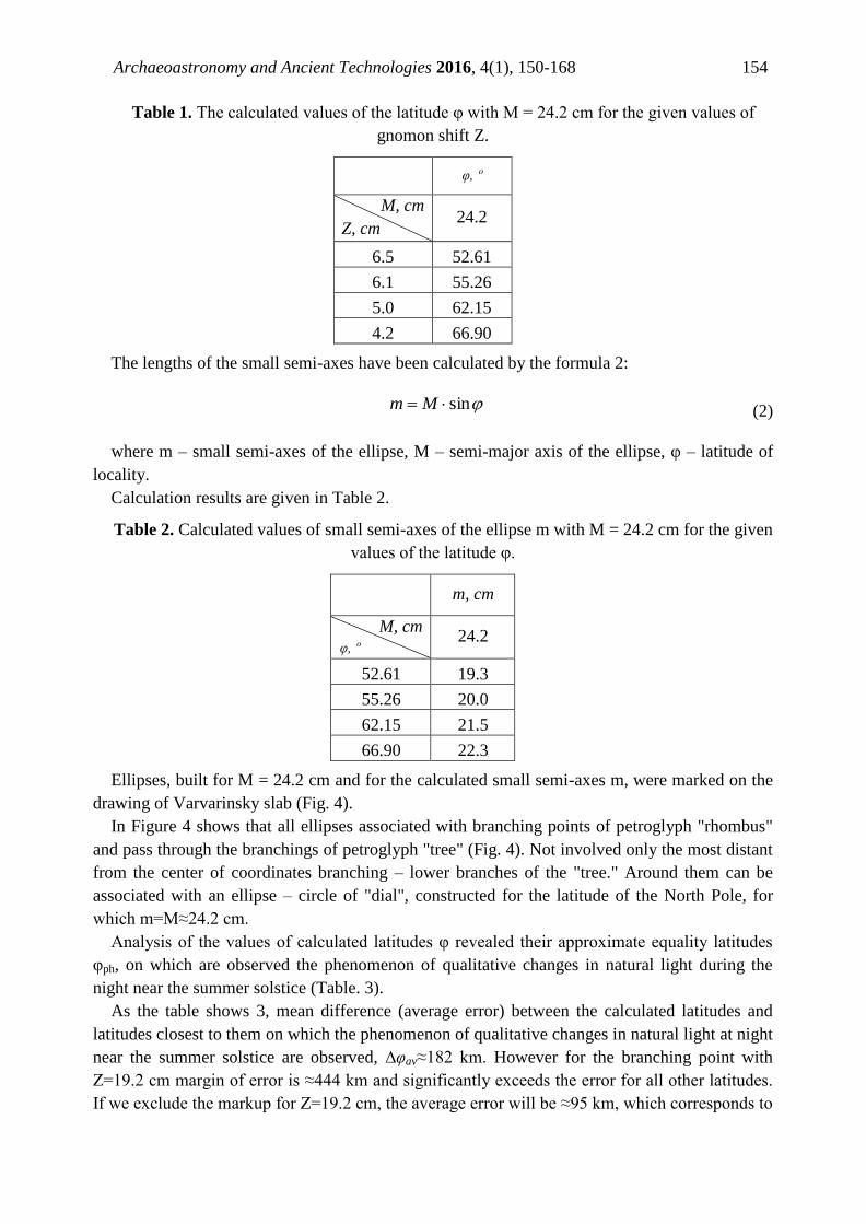
Archaeoastronomy and Ancient Technologies 2016, 4(1), 150-168 154
Table 1. The calculated values of the latitude φ with M = 24.2 cm for the given values of
gnomon shift Z.
φ, º
M, cm
Z, cm 24.2
6.5 52.61
6.1 55.26
5.0 62.15
4.2 66.90
The lengths of the small semi-axes have been calculated by the formula 2:
sin Mm (2)
where m – small semi-axes of the ellipse, M – semi-major axis of the ellipse, φ – latitude of
locality.
Calculation results are given in Table 2.
Table 2. Calculated values of small semi-axes of the ellipse m with M = 24.2 cm for the given
values of the latitude φ.
m, cm
M, cm
φ, º 24.2
52.61 19.3
55.26 20.0
62.15 21.5
66.90 22.3
Ellipses, built for M = 24.2 cm and for the calculated small semi-axes m, were marked on the
drawing of Varvarinsky slab (Fig. 4).
In Figure 4 shows that all ellipses associated with branching points of petroglyph "rhombus"
and pass through the branchings of petroglyph "tree" (Fig. 4). Not involved only the most distant
from the center of coordinates branching – lower branches of the "tree." Around them can be
associated with an ellipse – circle of "dial", constructed for the latitude of the North Pole, for
which m=M≈24.2 cm.
Analysis of the values of calculated latitudes φ revealed their approximate equality latitudes
φph, on which are observed the phenomenon of qualitative changes in natural light during the
night near the summer solstice (Table. 3).
As the table shows 3, mean difference (average error) between the calculated latitudes and
latitudes closest to them on which the phenomenon of qualitative changes in natural light at night
near the summer solstice are observed, ∆φav≈182 km. However for the branching point with
Z=19.2 cm margin of error is ≈444 km and significantly exceeds the error for all other latitudes.
If we exclude the markup for Z=19.2 cm, the average error will be ≈95 km, which corresponds to

Archaeoastronomy and Ancient Technologies 2016, 4(1), 150-168 155
about 1º of latitude. According to our estimates most marks were made with the same precision
on Varvarinsky slab [2].
Figure 3. Kurgan field Varvarinsky I, kurgan 1 (neighborhood), a stone slab with
petroglyphs, drawing of slab with deposited ellipses of the analemmatic sundial "dials" with
semi-major axis M≈24.2 cm. Green lines, passing through the points of petroglyph "rhombus"
branchings, note the distance Z, on which gnomon is necessary to shift in the days of solstices.
Petroglyph "tree" is highlighted gray oval.
Thus, petroglyph "tree" may define minor semiaxes of the "dial" ellipse of analemmatic
sundials m with M=24.2 cm for northern latitudes up to the North Pole, and marks on the slab
the direction to the north like the arrow on modern maps and drawings.
Discovered on Varvarinsky slab auxiliary markings for construction of ellipses of
analemmatic sundials on the northern latitudes is not evidence the reality of traveling to the
North in the Bronze Age. It is the most probable that it shows idea of the ancient population of
how design features of the analemmatic sundials for different territories had to change. Data for
northern territories, up to the North Pole, could be received by means of qualitative (not
connected with calculations) extrapolations – distribution of the conclusions received from
observation of visible motion of the Sun at the southern and middle latitudes to northern
latitudes. Than to more northern latitudes ellipse is marked, the minor semiaxes m is less differs
from semi-major axis M. At the North Pole they must be equal and the ellipse will be
transformed into a circle.
The aspiration to construct a tool for the latitude of the North Pole and reach the pole could
occur in the ancient population, for example, under the influence of the dominant mythological
ideas about sacred geography of the surrounding world, about the location of the abode of the
gods.

Archaeoastronomy and Ancient Technologies 2016, 4(1), 150-168 156
Table 3. Calculated values of north latitude φ for an "dial" ellipse of analemmatic sundial
with semi-major axis M = 24.2 cm for different values of small semi-axes m.
m – small semi-axes, φ – latitude of locality, φph – latitude at which is observed phenomenon
of a qualitative change lighting at night near the summer solstice, ∆φ – difference between the
calculated latitude and closest to it latitude of the observed phenomenon of qualitative alteration
of the natural lighting at night near the summer solstice (Δφ=φ-φph), Δl – distance corresponding
to the difference between the calculated latitude and the nearest latitude of the observed
phenomenon.
m,
cm φ, º φph, º ∆φ, º
∆l,
km Phenomenon
24.2 90.0 90.0 0.0 0.0
The latitude of the North Pole, where in the
summer polar days with duration of more than six
months are observed
22.3 66.90 66.57 0.33 35.9
The latitude of the Arctic Circle, beginning with
which and to the north in the summer polar days
(when the Sun does not descend below the
horizon longer than one day in the year) are
observed
21.4 62.15 60.57 1.58 174.0
The latitude of "white nights", beginning with
which and to the north, near the summer solstice
the Sun does not descend lower than 6º (occur
only civil twilight) and the starry sky is
impossible to observe
19.8 55.26 54.57 0.69 75.6
The latitude, beginning with which and to the
north near the summer solstice the Sun does not
descend lower than 12º (occur only civil and
nautical twilight) and only the brightest stars are
observed
19.2 52.61 48.57 4.04 444.2
The latitude, beginning with which and to the
north near the summer solstice the Sun does not
descend lower than 18º (come all kinds of
twilight, but the astronomical night does not
occur), so that the observation of the Milky Way
and faint stars is impossible
So modern researchers define tribes of Srubna culture as Indo-Iranian ethnic groups [18] or
Iranian group of Indo-European language family [19-22]. An idea about the astronomical and
natural phenomena specific to the latitude of the Far North existed among the ancient Iranians.
For example, in the description of abode of the first king Yima the following phrases are present:
"The stars, Moon and Sun seem setting and rising one time", "year seemed one day" (Videvdat
2.40-41). In the ancient Indian sacred books and epics reported about the constellations which do
not descend below the horizon and called "nonsetting"; polar star2 "in the middle of heaven";
distant countries, where day and night lasts for half a year, etc. [23, p. 76]. Such descriptions are
characteristic for circumpolar regions.
2 Various stars are becoming polar stars - the stars closest to the Pole of the World - because of the precession of
the equinoxes and proper motions of stars at different times.

Archaeoastronomy and Ancient Technologies 2016, 4(1), 150-168 157
In the ancient Indian and Iranian traditions of the world mountain, which is located in the
North, often appears. So the in the oldest parts of the "Avesta", created at the end of the II
millennium BC, the direction to the North associated with the sacred mountain Hara Berezaiti,
around which hosts of heaven revolved. Mountain was situated, as well as the Indian mythical
Mount Meru, at far North and also, like Meru, is the abode of the gods. The Avesta describes
that "blissful abode" of Yima is near Hara Berezaiti [24, p. 46-48], where the chosen people live
among the beautiful nature, without diseases, worries and envy, where heat, cold, death there
were not (Yasht 10.50-51).
Legends about of northern country Hyperborea was first mentioned by Homer in the Iliad
(Iliad 15. 171; 19. 358) and described in detail by Herodotus (Herodot History, Book IV,
Chapters 32-36) are also likely to reflect the mythical representation about a happy northern
country, similar to the ancient Indian and Avestan traditions. In ancient sources described what
people in Hyperborea lived to old age accompanied by songs, dances, music and feasts, in the
eternal fun and prayers (Pind. Pyth. X 29-4T; Plin. Nat. hist. IV 26).
"World Pillar", "Axis for Peace" (Axis mundi), "The World Tree" (Arbor mundi) and the like,
which are usually placed in the sacred center of the world are cultural and historical versions of
the World mountains [25, p. 398-406].
Petroglyph "tree" on Varvarinsky slab marks the direction to the North, as a projection of the
North Pole of the World on the surface of the Earth, which simulates by the slab. Petroglyph is
the image of the World Tree / World Mountains in fact. The trunk of the "tree" can be regarded
as accordance to the astronomical Axis of the World3. And its branches can be seen as symbols
of the Sun visible daily paths across the sky at different latitudes. Petroglyph "tree" on the slab
somewhat displaced relative to the Y-axis - the direction to the North in the plane of the slab
(Fig. 6a). Perhaps it was an attempt display the fact that the Pole of the World4 and, accordingly,
the polar star, at all latitudes, except the North Pole, does not coincide with zenith ("center" of
the sky). Polus of the World will always be slightly below it (Fig. 6b), except for the "ideal" the
direction to the North, observed only at the North Pole, where the North Pole of the World
coincides with the point of zenith. A similar way depicted, for example, the wheels in the
planning projections, when they were drawn beside a cart in the Bronze Age sometimes (Fig. 6c)
[26].
Gnomon of analemmatic sundial, which is a vertically standing rod, is a symbol and model of
a standing person (Fig. 6b). If look at the petroglyph "tree" on the part of the gnomon / person,
the "tree" would be inverted - with roots to the edge of slab and the top - to the center and the
gnomon (Figure 6a). Petroglyph "tree" is the projection of Pole of the World / polar star on the
surface of the slab in fact and symbolizes the World Tree, located in the sky with the apex
directed towards the ground and the roots directed to the sky.
The image of an inverted World Tree existed in various traditions, starting with the ancient
Indian sacred texts, the Arab citations to Plato, writings of Philo of Alexandria, and ending
Manichean and Kabbalistic sources, ancient Russian literature and Great Russianin incantations
[28]. In India, most often as the World Tree is seen inverted tree - Asvattha (Ficus religiosa)
(Atharva Veda II, 7, 3): " The root is at the top, branches are at the bottom, it is - the eternal
3 Axis of the World - an imaginary line passing through the Center of the World, around which there is a rotation
of the celestial sphere. 4 Pole of the World - the point on the celestial sphere, around which there is a visible daily motion of stars due to
the Earth's rotation around its axis.

Archaeoastronomy and Ancient Technologies 2016, 4(1), 150-168 158
ashvattha" (Katha Upanishad II, 3, 1) or "Its root is at the top - three feet Brahman (its) branches
- space, air, fire, water, earth and more. This is Brahman, calling a single Asvattha"
(Maytrayaniya Upanishad VI, 4). In the Russian incantations the following description of an
inverted World Tree is found: "On the sea on Okeyane, on an island on Kurgan white birch tree
stands, branches are down, roots are up" [29]. "Shamanic tree", which has an inverted view, was
found on the river Botchi in the settlements of Orochi also [29]. Birch Lapps used to create an
image of the god of thunder, and, the body is made from its trunk, and the head was made from
the roots [30, p. 165]. The Lapps did the image of the god of thunder from birch, torso made of
its trunk and the head is made from the roots [30, p. 165]. Description of the image of an
inverted tree in indigenous shamanic traditions of the northern Siberian and Far Eastern peoples
can also be found and in studies of ethnographers V.V. Tcharnolussky [31, p. 79], L.Y.
Sternberg [32], Ch.M. Taksami [33].
a
c b
Figure 6. Kurgan field Varvarinsky I, kurgan 1 (neighborhood), a stone slab with
petroglyphs: a – drawing, drawing slab; petroglyph "tree" enclosed in an oval green color, b –
modeling of the earth's surface using Varvarinsky slab (figure is based on [27, fig 1.91.]), c –
image of wheeled carts of the Bronze Age in the planned projection [26, Fig. 19].

Archaeoastronomy and Ancient Technologies 2016, 4(1), 150-168 159
The reason of the inverted location of the World Tree / shamanic tree in these traditions is not
explained. Taking into account that the image of the inverted World Tree meets in traditional
cosmologies much less frequently than the image is not of the inverted tree, but it is present in
the most ancient written sources - the Vedas, and was discovered by us on a stone slab of the
Bronze Age, we think that this fact is associated with a larger antiquity of the inverted image of
the world tree, compared to non-inverted. Appears, that throughout the ages, has occurred
gradual loss of knowledge about the rational component of this symbol, and image of the
inverted tree has been replaced by a more ordinary and understandable image - the image is not
inverted tree. About initial image is preserved only fragmentary evidence, scattered among
different cultures.
Thus a rational explanation of the inverted image of the World Tree, in our view, due to its
symbolic identification with the Axis of the World. In this case the base of its stem (root) can be
considered as the North Pole of the World, or the polar star, and the branchesas are visible paths
of the Sun and perhaps the stars at different latitudes (or at different distances from the North
Pole of the world or the geographic North Pole).
On the Srubna of vessels – molded pottery - inverted tree image encountered, too (Fig. 7a –
7d). In some cases, next to the inverted tree inverted animal is portrayed as on the vessel from
the burial ground Fedorovsky II (Fig. 7a). In Figure 7e vessel with an image unturned trees or
shrubs shows, and in Figure 7f - with image unturned animals, most likely horses, shows for
comparison.
a b
c
d e
f
Figure 7. Srubna vessels with signs: a - burial ground II Fedorovsky, kurgan 3, burial 3 [34,
Fig. 58.3], b - burial ground Staraya Toyda, kurgan 4, mound [34, Fig. 4.1], c - burial ground
Bol'shaya Dmitrievka II, kurgan 5, burial 3 [34, Fig. 4.7], d - burial ground Sukhaya Saratovka,
mound 2, burial 2 [34, Fig. 26.7], e - burial ground Zamozhnoe, kurgan 2, 3 burial [34, Fig.
32.3], f - burial ground Polyanki [34, Fig. 42.4].

Archaeoastronomy and Ancient Technologies 2016, 4(1), 150-168 160
In cases of realistic image of the tree (Fig. 7a, 7c), discrepancies in the interpretation of the
signs of tree does not arise. On both images tree branches are arranged symmetrically with
respect to the trunk and edges of branches raised toward the top of the tree. In the first case this
feature is less pronounced and the branches are arranged almost horizontally, as in the case of
tree on Varvarinsky slab. The pyramidal shape of the crown and whorled branching are
characteristic of coniferous trees of pine family. And, pines, have cone-shaped krone in youth,
and in old age - roundish or umbrella-shaped, flat krone (Fig. 8). Trees of family of pine
(Pinaceae) are eurysynusic in many regions: from tropical to subarctic geographical belts, but
mainly, in moderate belt of the northern hemisphere [35, page 133-173]. Thus, as mythical
World tree the srubny population, most likely, represented tree of family of pine. This or that sort
of this family could serve as local symbol: Pine, Fir-tree, Cedar, Larch, Fir, the most widespread
in the specific region.
a
b
c
Figure 8. Family Pine (Pinaceae), genus Pine (Pinus sylvestris): a - saplings5; b - young trees
6; c
- tree of age over 300 years7.
In cases more abstract images of a tree - signs in the form of two branches on one stalk (Fig.
7b, 7c, 7d), a sign that we interpret as the schematic representation of tree, some researchers are
sometimes described as anthropomorphic sign [34, p. 64; 36, p. 48-50], as a sign of boom or a
flying bird (the signs in the form of an acute angle with a long bisector) [37].
However, from our point of view, the interpretation of such signs as symbols of tree, looks
more justified, especially when you consider that in the described cases, we talking about the
inverted World Tree associated with the world of gods and deceased ancestors. In ethnography
and folklore of many peoples there are ideas that in the realm of the dead all the way around -
5 http://hvoinie.ru/wp-content/uploads/2012/08/Посадка-сосны-обыкновенной-осенью.jpeg
6 http://www.deepdale-trees.co.uk/trees/2011/03-Pinus-sylvestris.html
7 http://www.geocaching.su/?pn=101&cid=6858

Archaeoastronomy and Ancient Technologies 2016, 4(1), 150-168 161
upside down. Ritual inversion practiced and carriers Sruba culture. Most brightly it is
demonstrated posed upside down vessels from altars and burials [38].
At Varvarinsky slab petroglyph "tree" is, in our view, a symbol of the World Tree located in
the area of North Pole of the World and in the plane of the slab indicates the direction to the
geographic North Pole, as a projection of the North Pole of the World on the earth's surface, that
simulates the slab. Therefore, Srubna images of inverted tree we also propose to consider, as a
symbols of the North Pole of the World and the geographic North Pole. In Figure 7b six-pointed
star is drawn next with a schematic view of an inverted tree, in our view, represents the polar
star, although some scholars interpret it as the image of the bull [36]. Four-beam stars are
depicted closer to the mouth of the vessel. It seems that they represent a group of stars (the
constellation or asterism – readily distinguishable group of stars) in the vicinity of the pole star.
In Figure 7c inverted tree is depicted next to the four-beam star in a similar manner. Above - a
strip of the points located along the corolla, from our point of view, depicts the starry sky.
Symbolic image of the inverted tree, but smaller sizes, is near inverted tree. We assume that in
such cases (doubles image of inverted tree) a second, smaller size tree, located farther away from
the "polar star", can be a symbol of the zenith point. Than starry sky observation latitude will be
closer to the north, the polar star (the North Pole of the World) and the zenith point will be
located closer to each other and they practically will coincide at latitude of the North Pole.
North Star was Beta Ursae Minoris (β Ursa Minor) during the existence of Srubna culture,
therefore inverted animal in the picture next to inverted tree in Figure 7a, can be regarded as the
constellation Ursa Minor and / or Ursa Major, which are located close to each other. In the
ancient Iranian tradition the North was venerated in connection with the location of the
constellation Ursa Major, which was perceived as the main constellation in the sky [39, p. 80].
Therefore, standing next to inverted tree animal in Figure 7a may also symbolize the
constellation Ursa Major. It is known that this constellation called Ursa Major (Hyginus 2, 1.1)
or Woz (Hyginus 2, 2.2) in Ancient Greece already. However, for the first time under the
"bearish" name Αρκτοζ this constellation is found only in Homer (Odyssey V, 262-281). In the
Rig Veda plural rkshās "stars" (Rig Veda I, 24, 10) is used for the name of this constellation, and
the constellation called the "Seven Stars" [40, p. 581]. It is therefore unlikely that the bear is
depicted in Fedorovsky vessel.
In Mesopotamia the two constellations associated with carts. Ursa Major was called the "Great
Cart" and Ursa Minor - "Heavenly Cart" or "Cart of Anu", where Anu - the supreme god of
heaven and father of the gods in the Mesopotamian pantheon [41, p. 295, 301]. The carts were
harnessed by oxen in Mesopotamia, as a rule, but the horns are clearly distinguishable in images
usually. Animal of Fyodorovsky vessel does not have horns. On a vessel from the burial ground
Sukhaya Saratovka (Fig. 7d) chariot drawn by, is likely, to a horse is shown next to the symbol
of an inverted tree. We assume, that this image of "Heaven carts" of the supreme god of the sky
of Srubna pantheon.
In the ancient Indian mythology Dyaus was the god of the sky, he was personified sky and
father of the gods, including Adityas - heavenly gods, originally (AB I, 32, 4). In the Rig Veda,
he is always mentioned along with Prithvi – goddess of the earth and mother of the gods (RV I,
160). Fatherhood of Dyaus is his only personified a trait almost, and its zoomorphic images - a
bull (RW I 160, 3; V 36, 5; 58, 6) or a stallion (X 68, 11) [42, p. 202]. However, since the
beginning of the Vedic period, place of Dyaus was occupied by another god - Varuna, who kept
all the heavenly attributes. Varuna is the greatest of the gods of the Vedic pantheon (RV II 27,

Archaeoastronomy and Ancient Technologies 2016, 4(1), 150-168 162
10; V 85, 3; VII 87, 6; X 132, 4). He is considered paramount among the heavenly gods - Aditi.
Varuna is associated with cosmic waters in all their diversity, he is the guardian of truth and
justice, "Pantocrator," the king above the world, gods and humans (RV II 27, 10; V 85, 3; VII 87,
6; X 132, 4) . Varuna the one who created the world and keeps it (PB IV 42, 3; VIII 41, 5). He
lights up the sky and the earth, strengthens the Sun, measures the Earth with the help of the Sun,
picks it up at the sky, his clothes are day and night. Varuna gave the movement to the Sun; it is
his eye (I 50, 6), he himself is a thousand-eyes (VII 34, 10).
However, the heavenly chariot in the Indo-European traditions is often considered as a solar
chariot. Mitra refers to solar deities in ancient Indian tradition, but in early Vedic period Varuna
forms a pair with Mithra, which is regarded as something single - Varuna-Mitra. Varuna along
with Mitra models a space as a whole. But Varuna constantly associate with the night, sometimes
was related with the day. Varuna "paved the way for the Sun" and made a "great channels for
days" (PB VII 87, 1). Mitra also had more pronounced solar functions and was not associated
with the night. Mitra was in the inside of the frame indicated by the kingdom of Varuna; he - like
the golden sun embryo in cosmic waters [43, p. 596].
Varuna in the Veda also described as god of the sky, which supports an inverted World Tree:
"In the bottomless (space) King Varuna with the pure force of action
Keep straight top of the tree.
(Branches) are directed downwards. Their foundation - on top.
Let will root in us the rays!
Because the king Varuna, made a wide
Way for the Sun, order to follow (behind him)..." [44, p. 28]
(RV I, 24, 7-8)
Thus, the chariot on the vessel from Sukhaya Saratovka, close to the inverted tree, most likely,
is the image of the heavenly chariot of the supreme god is analog of Varuna. The horse is
depicted in Fedorovskoye vessel near the tree, perhaps symbolizing the heavenly chariot. In the
the Vedic language aśvattha ( "World Tree" - ficus religiosa), aśvayupa ( "sacrificial pillar")
formed by aśva-, means "horse" [45, p. 75-138].
In the Russian folklore Ursa Major constellation is sometimes called the "horse to the hitching
post" or "humpbacked gelding", that some researchers explain the Turkic influence [46, p. 84-
89].
It should also be noted that this constellation was depicted as a bull's front legs originally in
Egypt, and later as a whole the figure of the bull; Babylonians called the Ursa Major
constellation – "Cart", the ancient Romans – "Seven bulls" and the Greeks – "Woz". "Elk" or
"deer" designation of the Ursa Major constellation are common in northern Eurasia [47], [48, p.
100-124]. The two stars of Ursa Minor, one of which is the Polar Star, called White and Grey
Gelding among Kazakhs [49, p. 12-14]. In a number of Russian dialects the Polar Star is called
"Stozhar", around which elk walks or horse on hitching post [50, p. 326]. Chukchi considered
that Polar Star - fixed stake for tether reindeers , around which other stars are moving [51, p.
112].
Interpretation of the inverted images as symbols of the heavenly deities, occurs, for example,
on some Lappish (Saami) shamanic drums with a central solar symbols and radial-centric system
of the image (Fig. 9).

Archaeoastronomy and Ancient Technologies 2016, 4(1), 150-168 163
The God Radien, his wife and son of Radien with his wife or sister are portrayed upside
supreme at the top of these drums [52, p. 32, 35]. In the Saami mythology Radien - the supreme
god. More archaic image of the supreme deity among the Scandinavian Saami - Veralden -
radien (Veralden-Olmany) - "Man (lord) of the Universe". It was believed that he supports the
vault of heaven and a tree or post - "support of the sky" placed over him altar [42, p. 462], which
is in fact symbolized the World Tree.
Figure 9. Lappish drums with radial-centric system images [50, Fig. 2, Figure 4]. Inverted
images of Radiena are marked number one in the top of the drums. The authors singled by dotted
line images of Radiena for clarity.
Thus, as a result of our study on Varvarinsky slab, identified by us as prototype of
analemmatic sundial, petroglyph "tree" has been revealed, which performs additional functions
markup. Mark up of ellipses of analemmatic sundial "dials" for northern latitudes was possible
with it.
Comparative analysis of the images at Varvarinsky slab and Srubna vessels allowed us to
determine the sign of the inverted tree, as a symbol denoting direction to the North and / or the
North Pole of the World among Srubna population and may be among their predecessors;
interpret some accompanying signs, as symbols of circumpolar stars and constellations
(asterisms), and the god similarly Varuna - the main heavenly deity of the Vedic pantheon,
identify as the supreme deity of Srubna pantheon.
The authors express their sincere gratitude for the support studies to T.F. Knyazeva, S.A.
Husser, A.N. Usachuk, V.A. Larenok and employees of the department of archaeological
heritage GOUK RO "Donskoe nasledie".

Archaeoastronomy and Ancient Technologies 2016, 4(1), 150-168 164
References
1. Fayfert, A.V. Petroglify na territorii Rostovskoy oblasti. [Petroglyphs in the
Rostov region]. Rostov-on-Don, Ed. GAUK RO "Donskoe nasledie", 2015, 68 p.
2. Vodolazhskaya L.N., Larenok P.A., Nevsky M.Yu. The prototype of ancient
analemmatic sundials (Rostov Oblast, Russia). Archaeoastronomy and Ancient
Technologies 2016, 4(1), 96-116.
3. Vodolazhskaya, L.N.; Usachuk, A.N.; Nevsky, M.Yu. Astronomical interpretation
of the signs on the vessel of the Bronze Age (Central Donbass).
Archaeoastronomy and Ancient Technologies 2015, 3(2), 43–60.
4. Vodolazhskaya, L.N.; Usachuk, A.N.; Nevsky, M.Yu. Marks of heliacal rising of
Sirius on the sundial of the Bronze Age. Archaeoastronomy and Ancient
Technologies 2015, 3(2), 23–42.
5. Vodolazhskaya, L.N.; Usachuk, A.N.; Nevsky, M.Yu. Clepsydra of the Bronze
Age from the Central Donbass. Archaeoastronomy and Ancient Technologies
2015, 3(1), 65–87.
6. Vodolazhskaya, L.N. Reconstruction of ancient Egyptian sundials.
Archaeoastronomy and Ancient Technologies 2014, 2(2), 1-18.
7. Vodolazhskaya, L.N.; Nevsky, M.Yu. Russian meteorite of the Bronze Age (rock
record). Archaeoastronomy and Ancient Technologies 2013, 1(2), 18-32.
8. Vodolazhskaya, L.N. Analemmatic and horizontal sundials of the Bronze Age
(Northern Black Sea Coast). Archaeoastronomy and Ancient Technologies 2013,
1(1), 68-88.
9. Vodolazhskaya, L.N.; Larenok, V.A. Arhaeoastronomical analysis of
Levinsadovka sacrificial complex (South Russia). Archaeoastronomy and Ancient
Technologies 2013, 1(1), 5-25.
10. Ponomarenko, V.O.; Sarychev, D.; Vodolazhskaya, L.N. Primenenie
rentgenofluorestsentnogo analiza dlya issledovaniya khimicheskogo sostava
amfornoy keramiki. [The use of X-ray fluorescence analysis for the study of the
chemical composition amphorae ceramic]. Vestnik Yuzhnogo nauchnogo tsentra
RAN. [Bulletin of the Southern Scientific Center, Russian Academy of Sciences].
2012, vol. 8, No 1, pp. 9-17
11. Vodolazhskaya, L.N.; Nevsky, M.Yu. Arxeoastronomicheskie issledovaniya
svyatilishha Karataevo-Livencovskogo kompleksa. [Arhaeoastronomical research
sanctuary Karataevo-Liventsovsky complex]. Metodika issledovaniya kul'tovyx
kompleksov. [Technique of study of religious complexes]. Barnaul: OOO Pyat'
plyus, 2012, pp. 5-13.
12. Vodolazhskaya, L.N.; Ponomarenko, V.O. Khimicheskiy sostav keramiki
svetloglinyanykh uzkogorlykh amfor varianta D tipa C IV iz Tanaisa . [The
chemical composition of the ceramic svetloglinyanyh narrow-necked amphorae
type D variant of the C IV Tanais]. Trudy III (XIX) Vserossiyskogo
arkheologicheskogo s"ezda. [Proceedings of III (XIX) All-Russian Archaeological
Congress]. Veliky Novgorod - Staraya Russa. T. I St. Petersburg, Moscow,
Novgorod the Great: 2011, pp. 307-308.
13. Vodolazhskaya L.N. Reconstruction of Heron’s Formulas for Calculatingthe
Volume of Vessels // Posluschny, Axel; Lambers, Karsten; Herzog, Imela, Layers

Archaeoastronomy and Ancient Technologies 2016, 4(1), 150-168 165
of Perception. Proceedings of the 35th International Conference on Computer
Applications and Quantitative Methods in Archaeology (CAA), Berlin, April 2–6,
2007., Kolloquien zur Vor-und Frühgeschichte, Bd. 10, Berlin: Habelt;
Propylaeum-DOC, pp. 1–7.
http://archiv.ub.uni-heidelberg.de/propylaeumdok/volltexte/2010/564
14. Vodolazhskaya, L.N.; Vodolazhsky, D.I.; Ilyukov, L.S. Metodika komp'yuternoy
fiksatsii graficheskogo materiala arkheologicheskikh raskopok na primere
Karataevskoy kreposti. [Technique of of computer fixing graphic material of
archaeological excavations on the example Karataevo fortress]. Informatsionnyy
byulleten' Assotsiatsii «Istoriya i Komp'yuter». [Information bulletin of the
Association "History and Computer".], 2003, No 31, pp. 248-258
15. Larenok, P.A. Kurgannye mogil'niki Tavriya 1 – 3. [Kurgan field Tavriya 1 – 3].
Kurgany Severo-Vostochnogo Priazov'ya: Katalog: (Neklinovskij i Matveevo-
Kurganskij rajony Rostovskoj oblasti). Materialy i issledovaniya Taganrogskoj
arxeologicheskoj e'kspedicii. [Mounds North Eastern Azov: Catalog:
(Neklinovskiy and Matveyev Kurgan district of Rostov region). Materials and
Research Taganrog archaeological expedition]. Vyp. III, TGLIAMZ. TAE' -
Rostov n/D, 1998, 260 p.
16. Vodolazhskaya, L.N.; Larenok, P.A.; Nevsky, M.Yu. Solnechnye chasy epokhi
bronzy iz srubnogo pogrebeniya mogil'nika Tavriya-1. [Sundial of Bronze Age
from the Srubna burial of kurgan field Tavriya-1]. Istoriko-arkheologicheskiy
al'manakh. [Historical-Archaeological Almanac]. Vol. 13, Armavir, Krasnodar,
Moscow, 2015, 184 p.
17. Vodolazhskaya, L.N.; Larenok, P.A.; Nevsky, M.Yu. Ancient astronomical
instrument from Srubna burial of kurgan field Tavriya-1 (Northern Black Sea
Coast). Archaeoastronomy and Ancient Technologies 2014, 2(2), 31-53.
18. Tolochko, P.P.; Kozak, D.N.; Motsya, O.P.; Murzіn, V.Y.; Otroshchenko, V.V.;
Sereda, S.P. Etnіchna іstorіya davn'oї Ukraїni. [Ethnic History of Ancient
Ukraine]. Kyiv Institute of Archaeology NAS of Ukraine, 2000, 280 p.
19. Kuzmina, E.E. Arii – put' na yug. [Aryan - way to the south]. Moscow; St.
Petersburg: "Letniy sad", 2008. 558 p.
20. Kuzmina, E.E. Otkuda prishli indoarii? : material. kul'tura plemen andronov.
obshchnosti i proiskhozhdenie indoirantse. [From where Indo-arias came? :
material culture of tribes of andronovsky community and origin of Indo-Iranians].
M.: "Nauka", 1994, 463 p.
21. Klein, L.S. Drevnie migratsii i proiskhozhdenie indoevropeyskikh narodov.
[Ancient migrations and origin of the Indo-European people]. SPb., 2007, 226 p.
22. Abayev, V. I. K voprosu o prarodine i drevneyshikh migratsiyakh indo-iranskikh
narodov. [To a question about an ancestral home and the most ancient migrations
of the Indo-Iranian people]. Drevniy Vostok i antichnyy mir. [Ancient East and
classical antiquity]. M., 1972, pp. 26-37.
23. Avesta v russkikh perevodakh (1861–1996). [Avesta in Russian translations
(1861-1996)]. SPb.: "Magazine "Neva", "Letniy sad", 1998, 480 p.

Archaeoastronomy and Ancient Technologies 2016, 4(1), 150-168 166
24. Bongard-Levin, G. M.; Grantovsky, E.A. Ot Skifii do Indii. Drevni arii: mify i
istoriya. [From Scythia to India. Ancient arias: myths and history]. M.: " Mysl' ",
1974. 206 p.
25. Toporov, V.N. Drevo Mirovoe. [World Tree]. Mify narodov mira: Entsiklopediya
v 2 tt. [Myths of the World: Encyclopedia in 2 vols]. - M .: "Sovetskaya
Entsiklopediya", 1980-1982. 671 p.
26. Esin, Y.N. Drevnyaya istoriya i traditsionnaya kul'tura. Drevneyshie
izobrazheniya Minusinskoy kotloviny. [Ancient history and traditional culture.
The oldest image of the Minusinsk basin]. Nauchnoe obozrenie Sayano Altaya.
[Scientifi.c Review of the Altai Sayan] 2012, 1 (3), 14-47.
27. Savoie, D. Sundials design construction and use. Springer, 2009. 180 p.
28. Khudyaev, A.S. Obraz Arbor inversa v sakral'nykh prostranstvakh Severnoy
Evrazii. [Image of Arbor inversa in the sacred spaces of Northern Eurasia].
Gumanitarnye i sotsial'nye nauki. [Humanities and Social Sciences] 2014, No 3,
131-139.
29. Kagarov, E.G. Mifologicheskiy obraz dereva, rastushchego kornyami vverkh.
[The mythological image of a tree growing roots up]. Doklady AN SSSR. [Reports
of the Academy of Sciences of the USSR], 1928. Series B. No 15.
30. Kharuzin, N.N. Russkie lopari. Ocherki proshlogo i sovremennogo byta. [Russian
Lapps. Sketches of the past and modern life]. M.: The highest approved
partnership Skoropechati A.A. Levenson, 1890. 482 p.
31. Charnolusky, V.V. V krayu letuchego kamnya. Zapiski etnografa. [At the edge of
the volatile stone. Notes ethnographer]. M., 1972, 270 p.
32. Sternberg, L.Y. Kul't orla u sibirskikh narodov. Etyud po sravnitel'nomu fol'kloru.
[The cult of the eagle of the Siberian peoples. Study of comparative folklore].
Sbornik Muzeya antropologii i etnografii. [Collected of the Museum of
Anthropology and Ethnography]. T. V. Vol. 2. L .: Publishing House of the USSR
Academy of Sciences, 1917-1925, pp. 717-740.
33. Taksami, Ch. M. Sistema kul'tov u nivkhov. [Worship System of Nivkhs]. Sbornik
Muzeya antropologii i etnografii. T. XXXIII: Pamyatniki kul'tury narodov Sibiri i
Severa: (2–ya polovina XIX – nachalo XX v.). [Collected of the Museum of
Anthropology and Ethnography. T. the XXXIII: Monuments of culture of the
peoples of Siberia and the North: (2nd half of XIX - early XX century.).
Leningrad: "Nauka", 1977, pp. 90-116.
34. Zakharova, E.Y. Sosudy so znakami srubnoy obshchnosti epokhi pozdney bronzy.
[Vessels with signs carcass generality of the Late Bronze Age]. Voronezh
TSCHKI, 2000, 163 p.
35. Flora SSSR. [Flora of the USSR]. Leningrad: Publisher Academy of Sciences of
the USSR, 1934, 302 p.
36. Zakharova, E.Y. Zakharova E.Yu. Znaki – risunki na srubnom sosude iz
kurgannogo mogil'nika u sela Staraya Toyda. [Signs - drawings on the Srubna
vessel from a burial mound near village Old Toyda]. Abashevskaya kul'turno-
istoricheskaya obshchnost' v sisteme drevnostey, epokhi bronzy lesostepi i stepi
Evrazii: tezisy dokladov mezhdunarodnoy nauchnoy konferentsii. [Abashevskaya
cultural-historical community in the system of Antiquities, Bronze Age steppe and

Archaeoastronomy and Ancient Technologies 2016, 4(1), 150-168 167
steppe of Eurasia: Abstracts of the International Scientific Conference]. Tambov,
1996, pp. 48-50.
37. Otroshchenko, V.V. Syuzhet perevtіlennya u znakoviy sistemi plemen zrubnoï
spіl'noti. [The story of transformation of znakoviy system of zrubnoï tribal
communities]. Arkheologicheskiy al'manakh. [Archaeological Almanac].
Donetsk, 1998, No 7, pp. 93-98.
38. Tsimidanov, V.V. Nartovskiy epos osetin i srubnaya kul'tura: poisk skhozhdeniy.
[Nart epic of Ossetians and carcass culture: find similarities]. Izvestiya SOIGSI.
[News SOIGSI]. Vol. 1 (40). Vladikavkaz, 2007.
39. Campbell, L.A. Mithraic Iconography and Ideology. Leiden, 1968. 444 p.
40. Pictet, A. Les origines indo-europeennes ou les Aryas primitifs, essai de
paleontology linguistique, Paris, J. Cherbuliez, 1863, Vol. II. 778 p.
41. Kurtik, G.E. Zvezdnoe nebo drevney Mesopotamii. [Starry sky of ancient
Mesopotamia]. SPb.: Aletheia, 2007. 744 p.
42. Mifologicheskiy slovar'. [The mythological dictionary]. M.: "Sovetskaya
entsiklopediya", 1991, 736 p.
43. Toporov, V.N. Issledovaniya po etimologii i semantike. Tom 2. Indoevropeyskie
yazyki i indoevropeistika. [Studies on the etymology and semantics. Volume 2.
Indo-European languages and Indo-European studies]. Bk. 2. M .: " Yazyki
slavyanskikh kul'tur ", 2006, 728 p.
44. Rigveda. Mandaly I-IV. [Rig Veda. Mandala I-IV]. M.: "Nauka", 1989. 768 p.
45. Ivanov, V.V. Opyt istolkovaniya drevneindiyskikh ritual'nykh i mifologicheskikh
terminov, obrazovannykh ot aśva- «kon'» (zhertvoprinoshenie konya i derevo
asvattha v drevney Indii). [Experience of interpreting of ancient Indian ritual and
mythological terms, formed by aśva- «horse» (horse sacrifice and asvattha tree in
ancient India)]. Problemy istorii, yazykov i kul'tury narodov Indii. [Problems of
history, language and culture of the peoples of India]. M., 1974, pp 75-138.
46. Rut, M.E. Vzaimodeystvie yazykov v oblasti narodnoy astronomii. [Interaction of
languages in the field of traditional astronomy]. Russkiy yazyk v ego
vzaimodeystvii s drugimi yazykami. [Russian language in its interaction with
other languages]. Tyumen: Tyumen State University, 1988, pp. 84-89.
47. Potanin, G.N. Otgoloski skazki o Eruslane. [The echoes of the tales of Eruslane].
Etnograficheskoe obozrenie. [Ethnographic Review]. No 4, 1901. pp. 1-34.
48. Lushnikova, A.V. Model' Universuma drevnikh kalendarey (lingvisticheskaya
rekonstruktsiya). [Model of the Universe of the ancient calendars (linguistic
reconstruction)]. Moscow: Institute of Linguistics of Russian Academy of
Sciences, 2004. 259 p.
49. Abishev, H. Elementy astronomii i pogoda v ustnom narodnom tvorchestve
kazakhov. [Elements of astronomy and weather in the folklore of the Kazakhs].
Academy of Sciences of KazSSR. Almaty: Publishing House of Academy of
Sciences of KazSSR, 1949. 29 p.
50. Dahl, V. Tolkovyy slovar' zhivogo velikorusskogo yazyka. [Explanatory
dictionary of living Great Russian language]. T. 4, Moscow " Russkiy yazyk",
1980. 683 p.

Archaeoastronomy and Ancient Technologies 2016, 4(1), 150-168 168
51. Bogoras, V.G. Luoravetlansko-russkiy (Chukotsko-russkiy) slovar'.
[Luoravetlansky-Russian (Chukchi-Russian) dictionary]. Moscow: Leningrad:
"Uchpedgiz", 1937, 164 p.
52. Friisk J.A. Lappisk mythology, Eventyr og Folkesagn. Christiania: Cammermeyer,
1871. 177 p.
List of Abbreviations
GOUK RO – Gosudarstvennoe Avtonomnoe Uchrezhdenie Kul'tury Rostovskoy Oblasti
[State autonomous organization of Culture of Rostov Region]
SOIGSI – Severo-Osetinskiy Institut Gumanitarnykh i Sotsial'nykh Issledovaniy [North
Ossetian Institute of Humanitarian and Social Research]
TAE – Taganrogskaya Arkheologicheskaya Ekspeditsiya [Taganrog Archaeological
Expedition]
TGLIAMZ – Taganrogskiy Gosudarstvennyy Literaturnyy i Istoriko- Arkhitekturnyy
Muzey-Zapovednik [Taganrog State Literary and Historico-Architectural Museum-Reserve]
© This article is an open access article distributed under the terms and conditions of the Creative
Commons by Attribution (CC-BY) license (http://creativecommons.org/licenses/by/4.0/).


