Download - GREENING GREATER HORSHAM

1 | MUNICIPAL TREE STRATEGY
A MUNICIPAL TREE STRATEGY
2021 - 2031
GREENINGGREATER HORSHAM
DRAFT V8 20 SEPT 2021

2 | MUNICIPAL TREE STRATEGY
The Horsham Rural City Council acknowledges the five Traditional Owner groups of this land – the Wotjobaluk, Wergaia (Were-guy-ya), Jupagalk, Jaadwa and Jadawadjali people. We recognise the important and ongoing place that all Indigenous people hold in our community
This document has been prepared by Horsham Rural City Council in partnership with Urban Forest Consulting

3 | MUNICIPAL TREE STRATEGY
CONTENTS
INTRODUCTION 4VISION 9KEY OBJECTIVES 10BENEFITS OF URBAN TREES 11HISTORY OF HORSHAM’S TREES 15STRATEGIC CONTEXT 18HORSHAM’S TREES TODAY 22 Tree canopy cover 23 Street trees 27 Tree planting sites 29REVIEW OF COUNCILS’ TREE MANAGEMENT PROGRAM 30CHALLENGES AND OPPORTUNITIES 40 Climate Change 40 Urban heat 42 Data and IT issues 43 Reactive asset management 43 Perception of trees 44 Infrastructureconflict 46 Integrated Planning and Development 48 Strategically planting trees in areas of need 49IMPLEMENTATION 52 Headline actions 54GLOSSARY 62REFERENCES 63

4 | MUNICIPAL TREE STRATEGY
INTRODUCTION Horsham Rural City Council (Council) understands that we need to protect and enhance our tree population to assist in addressing climate change and the urban heat effect. The Wimmera region has already become warmer and drier – a climate trend likely to continue into the future. Getting climate ready involves understanding how the climate is likely to affect our region and working out ways to mitigate and adapt. We recognise that by increasing tree cover and improving tree health across our urban areas we can better adapt our townships to climate change, improve the health of our natural environment and residents, and protect the future liveability of our City.
Our urban and rural trees are invaluable contributors to our region. Not only do they help our region adapt to and mitigate the increasingeffectsofclimatechangeandcontribute to our community’s health and wellbeing, they also cool and shade our townships, intercept stormwater, provide habitat for wildlife, create green inviting spaces for our community to enjoy and add to our sense of place and local character.
While we recognise that trees are a valuable asset to our community, we still do not have a complete picture of the extent and diversity of our trees, including trees on private land
A COMMITMENT TO ADDRESSING CLIMATE CHANGE
whichmakeupasignificantproportionofthe tree population and canopy cover across urban Horsham. We know that our overall tree canopy cover is relatively low at 12.8% for the whole Municipality and 13% for the urban area of Horsham and Haven. A lack of species diversity is also an issue for our street trees. This problem has been exacerbated by an absence of forward planning provided by a strategic framework for our tree management program, exposing us to potential risks. We recognisetherearesignificantopportunitiesforus to improve the way we manage our trees to address the challenges of climate change and the community’s perception of trees and risk.
This Strategy commits us to better managing our tree assets so we can maximise their benefitsandourreturnoninvestmentinthem.We understand the need to better care for our existing trees to improve their overall health, as well as the need to plant more trees across our townships. This strategy also explores the role that private trees play towards climate change adaptation and community health and explores ways for us to better protect and enhance them. Our Vision is that our trees will be healthy, vibrant and valued assets of the municipality’s infrastructure. Using integrated, sustainable management practices, Council will create a

5 | MUNICIPAL TREE STRATEGY
welcoming landscape with a canopy cover that supports biodiversity and climate resilience and contributes to the community’s physical and mental well-being.
To help us meet our vision, we have set some targets to improve the tree canopy cover over our urban areas, streets and roads, the Central Activity District, and parklands. We will also seek to undertake better planning for trees in growth areas and future growth areas that are yet to be developed as well as better managing significanttreesonprivateland.Tohelpguideus towards meeting these targets, we are committing to a range of actions, in particular:
• Understanding the extent and quality of our existing urban and rural trees
• Building a proactive tree maintenance program to improve the quality, health and viability of existing trees
• Continuing to plant and renew trees in areas of need using best practice planning and planting methods
• Identifying opportunities to increase canopy in areas where increased amenity and connectivityareneededasidentifiedinotherstrategic documents
• Engaging, educating and collaborating with our community and regional partners
• Ensuring that our upcoming Planning SchemeReviewreflectstheissuesidentifiedin this Tree Strategy, particularly the role that private trees play and how we can better protect and enhance them.
By committing to our vision, targets and actions, we are confident that we can improve the overall liveability of our townships, improve health and wellbeing and help our region adapt to climate change.
The best time to plant a tree was 20 years ago. The next best time is NOW.

6|MUNICIPALTREESTRATEGY
TREE CANOPY TARGETSWe are committing to a suite of tree canopy targets that will help guide our tree protection and planting on Council lands. These targets will provide the impetus to implement best practice tree protection, proactive care and maintenance of our existing trees and a tree planting program targeted at areas where canopy cover is needed.
Council will commit to the following by 2040:
1. Tree canopy cover over our urban and rural road reserves will be increased from 20% to 25%
2. Tree canopy cover over the urban area of Horsham (inclusive of private land) will be increased from 15.3% to 20%
3. Tree Canopy cover over the public areas of the Central Activity District will be increased from 9.9% to 15%
4. Tree Canopy cover over parklands will be increased from 16% to 25%
Further analysis will be undertaken to establish trends of change in tree canopy across these various land types so as to determine the most appropriate courses of action and responsibilities. A tree inventory will be established to allow closer monitoring of individual trees, their overall health and diversity and their contribution to tree canopy.
Without burdening property owners, measures will be explored that seek to minimise the loss of tree canopy on private land that occur through removal and development.. This will assist in reaching the second of the four canopy targets and to increase that target into the future. Measures to explore include the introduction of a Local Law that requires a permit for the removal of larger trees, as well as identifying Significant Trees on private land that would be given a level of planning protection.

7 | MUNICIPAL TREE STRATEGY
SCOPE AND PURPOSE This strategy provides the background context, current situation and desired outcomes for Horsham Rural City Council’s urban street, park and rural roadside trees. This includes trees within
Image 1: This Tree Strategy will focus on the management of street and park trees in urban centres, rural roadsides and townships. Townships included in the map are those with pop.> 150 people Note: This map shows the current township boundaries which existing canopy cover has been calculated. Private land, growth areas and future growth areas outside of this boundary will contribute to meeting the canopy cover targets set in this strategy, as future development progresses and is approved through the Planning Scheme. (See Image 16 for more detail).
Horsham township, along rural roads and within smaller townships throughout the municipality. The strategy also flags further investigations and work for trees on private land.

8 | MUNICIPAL TREE STRATEGY
Council recognises the large array of benefits our urban and rural roadside trees provide our community and the environment. Through this Strategy, we are committed to maximising these benefits.
Image 2: Our street trees cool and shade our townships
We will manage our trees to help our region adapt to climate change, improve health and wellbeing, cool and shade our townships, improve landscape amenity and enhance our region’s biodiversity.

9 | MUNICIPAL TREE STRATEGY
VISIONTrees will be healthy, vibrant and valued assets of the municipality’s infrastructure. Using integrated, sustainable management practices, Council will create a welcoming landscape with a canopy cover
Image 3: Council will create a welcoming landscape with a canopy cover that supports biodiversity and climate resilience
that supports biodiversity and climate resilience, contributes to the community’s physical and mental well-being and raises awareness of the importance of culturally significant trees.

10 | MUNICIPAL TREE STRATEGY
KEYOBJECTIVESThis Strategy seeks to embed the following objectives into Council’s everyday business:
1. Protect and enhance existing public trees Ensure existing trees are protected from unnecessary removal or damage and that they are cared for to ensure longevity, optimum health and minimisation of risk.
2. Increase tree canopy cover Improve the cover of natural shade in our townships to create attractive and walkable streets.
3. Improve streetscape character and biodiversity linkages of Horsham and townships including river frontage Utilise tree planting to improve the look and feel of our streetscapes and to increase connectivity and habitat for biodiversity.
4. Educate and engage with the community Raise awareness within our community about the importance of urban trees, including on private land and increase participation in decision making.
5. Deliver a best practice tree management program Ensure the care of our trees is based on industry best practice of urban tree management techniques and methods.
6. Celebrate cultural heritage Plan for the City’s landscape to help define its character, culture and image and reinforce the value placed on culturally and historically significant trees.

11 | MUNICIPAL TREE STRATEGY
BENEFITS OFURBAN TREES
Image 4: Quadruple bottom line benefits of urban trees
ENVIRONMENTAL• Filter pollution & provide clean air• Rainfall interception & reduced
stormwater runoff• Improve water quality• Habitat connectivity &
biodiversity maintenance• Carbon sequestration• Improve soil health• Ameliorate climate change
impacts• Thermal insulation and
temperature modification
SOCIAL• Provide shade & cooling, reducing
urban heat• Improve amenity and aesthetics• Provide recreation opportunities• Encourage social cohesion• Promote health & well-being
through reduced stress and increased active living
• Provide wind breaks
CULTURAL• Creation of local identity• Marketing the town• Connecting to the past
Trees and other vegetation in cities and regional centres around the world are now regarded as providing critical “living” infrastructure – being as important as roads or public transport to how a city, town or region functions.
The benefits of urban trees span environmental, economic, social and cultural domains. These benefits are often interrelated, supporting resilient and sustainable urban and rural landscapes.
ECONOMIC• Increased property values• Increased business patronage &
productivity• Increased tourism opportunities• Reduced costs of stormwater
infrastructure• Reduced public health costs• Energy use savings• Lower GHG emissions

12 | MUNICIPAL TREE STRATEGY
ENVIRONMENTAL BENEFITS• Provide shade and cool our townships
An increase in tree canopy and greening can reduce air and surface temperatures by 3 to 20oC. (Gil et al 2007)
• Reduce storm water flows, pollution and nutrient loads Tree canopies and root systems reduce storm water flows and nutrient runoff into our waterways. Streets with higher vegetation cover are three to six times more effective in managing storm water than conventional methods (Norton et al, 2013)
• Provide habitat and enhance levels of biodiversity Urban and rural roadside trees support a wide range of species, even endangered animals and other species of high conservation value. (Kendal et al, 2016)
SOCIAL BENEFITS• Encouraging outdoor activity
Well-vegetated parks, gardens and streets encourage the use of open spaces, with health benefits such as reduced obesity and increased physical activity levels and promote more sustainable forms of transportation. (van Dillen, 2012)
• Reducing sun exposure The prevalence of skin cancer and other illnesses due to sun exposure identify the need for protection from sunlight’s UV rays is vital. Tree shade can reduce overall exposure to UV radiation by up to 75 per cent. (Mullaney et al., 2015)
• Improving mental wellbeing Access to, and views of, green spaces and trees have positive effects on people’s wellbeing. (Karden, 2016)

13 | MUNICIPAL TREE STRATEGY
ECONOMIC BENEFITS• Reducing energy costs
Energy saving benefits come through shading and sheltering buildings from the sun in summer and allowing sunlight in winter. (Simpson, 1996)
• Increasing property values Trees in streets enhance neighbourhood aesthetics and increase property values. Properties in tree-lined streets are valued approximately 30% higher than those in streets without trees. (Plant, 2017)
• Increased retail activity Shoppers spend longer and more money in retail areas where the area is landscaped and trees provide shade and amenity. (Wolf, 2005
• Return on investment Cities across the world have demonstrated that trees create a positive return on investment. It has been calculated that for every dollar spent on a tree, $5.60 worth of benefits were returned. (US Forest Service, 2020)
CULTURAL BENEFITS• Creation of local identity
A city’s landscape helps define its character. Trees and vegetation can physically define a place. Trees provide landscape amenity and integrate nature into the urban environment..
• Marketing the City Green spaces play a role in defining the culture and image of a city. A city is more competitive with an expanded political and economic influence when the built and natural urban environment is attractive and welcoming.
• Reinforcing First Nations status Culturally significant trees are a vital and tangible link to the continuous connection to place for First Nations people. Culturally significant trees are clear evidence of Indigenous community’s existence on this land for thousands of years, prior to colonial settlement. Culturally significant trees are important sentinels to interpret and connect to the landscape and a cultural marker to pass valuable cultural knowledge to subsequent generations.

14 | MUNICIPAL TREE STRATEGY
Image 5: Research shows that shoppers spend longer and more money in well treed and landscaped retail precincts. These pop-up parks in Horsham CAD have been a huge success with the community utilising the new spaces.

15 | MUNICIPAL TREE STRATEGY
HISTORYOF HORSHAM’S TREESHorsham Rural City has a rich and ongoing history of Aboriginal culture, recognised in 2005 with a successful native title claim by First Nations peoples of lands along the Wimmera River. There are five First Nations of the land: the Jaadwa, Jadawadjali, Jupagulk, Wergaia and Wotjobaluk peoples.
Image 6: Sketch of the Wimmera River, 1845, unknown artist (National Library of Australia)
POST SETTLEMENT GREENINGSince European settlement, agriculture has become the mainstay industry of the region. Broad acre cropping of cereals, pulses and oilseeds are now the predominant land use and main economic drivers of rural land use in the Wimmera. Much of the pre-settlement
Before settlement, the First Nations people had long occupied the Horsham area and drew on a rich food supply, especially along the Wimmera River, where they cut bark from the River Red Gums to make canoes. (Note: input into this section is being sought from BGLC and will be re-edited once this input is provided)
vegetation has been cleared with many of the original vegetation communities now recognised as being endangered. Much of these vegetation communities are found on private land and along our rural roadsides. Rural roads play a critical role in protecting remnant trees.

16|MUNICIPALTREESTRATEGY
In 1855, the initial town planning for Horsham placed the town centre some distance from the river, with the placement likely because of the risks of riverine flooding. The town siting enabled the retention of areas of native vegetation along the river frontage with other areas of the river front used for public recreational and utility purposes.
In the period of rapid growth through the 1870s and 1880s there were significant street tree plantings championed by Councillor Thomas Young. The site of the Botanic Gardens was also reserved in 1878. Early street tree plantings during this time included Silver Poplars in Firebrace Street in the 1870s, Elms in Bowden Street in the 1880s and Sugar Gums planted in Stawell Road (Western Highway) near Green Park. Property owners were responsible for the care of the tree outside their property.
Image 7: Street trees outside Horsham District High School, c.1912 (State Library of Victoria) Corner of Roberts Avenue and Urquhart Street.
Later in the 19th century, Councillor John Langlands donated the trees that were planted along Natimuk Road. The management of the street trees became the responsibility of Thomas Brown, curator of the Botanic Gardens. In 1897, the issue of species preferences was raised with disparaging reports appearing in the local newspaper regarding the planting of silver poplars along some of the main thoroughfares.
In 1904, Curator Brown recognised the benefits of this early tree planting noting the healthy growth and pleasing appearance of trees in the principal streets of Horsham. Brown also indicated that tree planting should continue more extensively than it had in the past.
17 | MUNICIPAL TREE STRATEGY
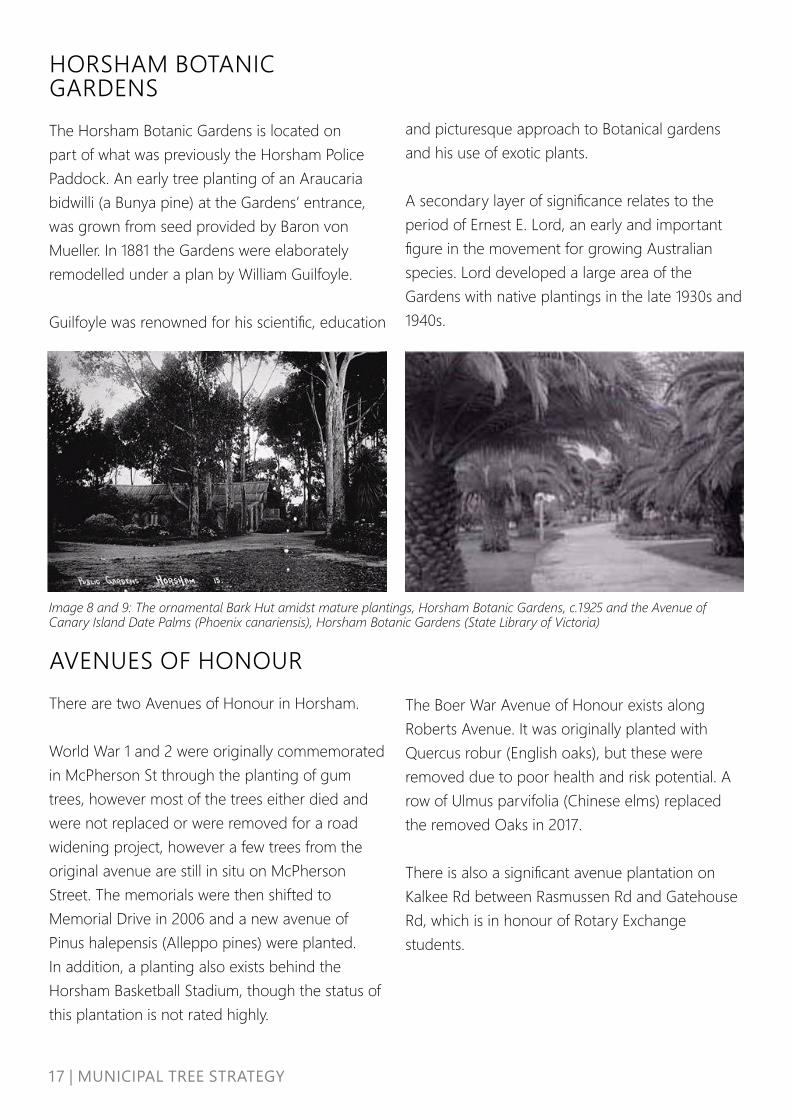
Image 8 and 9: The ornamental Bark Hut amidst mature plantings, Horsham Botanic Gardens, c.1925 and the Avenue of Canary Island Date Palms (Phoenix canariensis), Horsham Botanic Gardens (State Library of Victoria)
HORSHAM BOTANIC GARDENSThe Horsham Botanic Gardens is located on part of what was previously the Horsham Police Paddock. An early tree planting of an Araucaria bidwilli (a Bunya pine) at the Gardens’ entrance, was grown from seed provided by Baron von Mueller. In 1881 the Gardens were elaborately remodelled under a plan by William Guilfoyle. Guilfoyle was renowned for his scientific, education
AVENUES OF HONOURThere are two Avenues of Honour in Horsham. World War 1 and 2 were originally commemorated in McPherson St through the planting of gum trees, however most of the trees either died and were not replaced or were removed for a road widening project, however a few trees from the original avenue are still in situ on McPherson Street. The memorials were then shifted to Memorial Drive in 2006 and a new avenue of Pinus halepensis (Alleppo pines) were planted. In addition, a planting also exists behind the Horsham Basketball Stadium, though the status of this plantation is not rated highly.
and picturesque approach to Botanical gardens and his use of exotic plants.
A secondary layer of significance relates to the period of Ernest E. Lord, an early and important figure in the movement for growing Australian species. Lord developed a large area of the Gardens with native plantings in the late 1930s and 1940s.
The Boer War Avenue of Honour exists along Roberts Avenue. It was originally planted with Quercus robur (English oaks), but these were removed due to poor health and risk potential. A row of Ulmus parvifolia (Chinese elms) replaced the removed Oaks in 2017.
There is also a significant avenue plantation on Kalkee Rd between Rasmussen Rd and Gatehouse Rd, which is in honour of Rotary Exchange students.

18 | MUNICIPAL TREE STRATEGY
STRATEGICCONTEXTThe management of street, park and rural roadside trees is governed by the following Council documents. The management of private trees are not currently included in any Council planning or operating documents so the gaps have been highlighted. LEGISLATED PLANS
1. Council Plan 2020-2024 • Goal 4 Asset Management: Priority 3.1.08
Develop improved park and street policy as an Urban Forest Plan (or Tree Strategy)
• Goal 5 Natural and Built Environments: Tree Strategy will support promotion of sustainability and sound environmental practice
2. Health and Wellbeing Plan 2017-2021• Priority 1 Increasing healthy eating and active
living: • Action 6 Develop and maintain footpaths
and walking and bike trails with particular focus on key precinct linkages to promote active living options and supporting infrastructure such as seats, signage, water, lighting and shade
3. Horsham Planning Scheme (Victorian Planning Provisions)• Clause 13.01 – Climate Change Impacts• Clause 13.01-1s – Natural Hazards and
Climate Change
INFLUENCING STRATEGIES 4. Environment Sustainability Strategy 2010Principal 2 Protect what we value: Ensure that Council-controlled land is managed in ways that protect and enhance native flora, fauna, natural habitat and indigenous cultural values
5. Horsham Framework for Managing Growth 2013The Horsham Framework for Managing Growth was adopted by Council in November 2013. It provides clear and consistent direction for decision makers, landowners, developers and the community on the location of future housing (e.g. growth areas, infill opportunity sites) to meet the future demand over a 20-to-30-year horizon.
6. Open Space Strategy 2019Provides Council with strategic directions to determine priorities for the planning, provision and development of open space across the municipality

19 | MUNICIPAL TREE STRATEGY
7. Municipal Bike and Shared Path Plan 2012-2015This report details the recommended bicycle route strategy for the Rural City of Horsham. This has been flagged to be updated.
8. Horsham Urban Transport Plan 2020Sets the directions and priorities for developing our transport system in a way that supports the goals of our community, our economy and environment.
9. CAD Revitalisation Streetscape Strategy 2017Focuses on guidance for infrastructure and Council-asset improvements that will form the core of the CAD revitalisation programme
10. Horsham North Urban Design Framework 2013Focuses on the physical interventions and outcomes, including streets and public spaces, buildings and landscape, and the potential of urban design to support and facilitate economic, social and environmental outcomes in Horsham North. This includes key pedestrian and cycle routes.
11. Roadside Vegetation Management Plan Provides the framework for Council’s protection of high value roadside vegetation and Council’s responsibilities under the Road Management Plan. Both plans are under review and will be updated before the end of 2021.
12. Electrical Line Clearance Management Plan 2020 Details the practices of risk assessment and maintenance works associated with ensuring safety of powerlines within the declared area.
CURRENT WORK13. Tree Management Policy 2021This document will be prepared in conjunction with the Strategy and will clearly articulate Council’s position regarding elements of tree management e.g. tree protection, removal, planting and establishment, trees and development etc. Again, this will meet an identified policy gap and will ensure that there is a consistent and best practice platform for Council to make decisions regarding trees. This policy will replace the 2010 Tree Policy which will no longer have effect.
20 | MUNICIPAL TREE STRATEGY
14. Horsham North Local Area PlanThe Horsham North Local Area Plan Project is based on a review of the Horsham North Urban Design Framework (UDF) and an assessment of the directions, strategies and actions contained in that document, in order to identify opportunities from which to create a new piece of work with an expanded scope and study area. The project aims to identify current issues under a series of themes such as Connectivity and Place Making and will provide a series of actions through an implementation plan.
15. Horsham CAD & Streetscape PlanUrbanFold have been engaged by Council to undertake the CAD Revitalisation project, which will involve an urban design analysis of the CAD followed by the creation of a streetscape plan that identifies public realm capital works projects to be undertaken by Council in the future. The Plan will focus on improving connectivity within the public realm at key locations throughout the CAD and is part of the overall City to River project. Trees will form an important component of the delivery work.
FUTURE PLANS16. Horsham Urban Renewal PlanThe Urban Renewal Project is intended to promote and facilitate new development in three distinct areas that are located between the main commercial area of Horsham (the CAD) and the river to the south. The aim is to transform and revitalise parts of the city to make them more attractive places to live, work, visit and invest in. This forms part of a suite of strategic projects being undertaken concurrently by Council with a view to creating a brighter future for Horsham over the coming decades.
The recently completed Horsham: City to River Vision & Masterplan sets out a long-term Vision and Masterplan for central Horsham and will be used to guide the revitalisation of the area over the next 20 to 30 years. The Urban Renewal Project will undertake site analysis and feasibility studies to develop indicative masterplans for the subject sites to facilitate future private development.
17. Horsham South Structure PlanThe Structure Plan will provide a clear vision and framework for the coordinated land use and development of Horsham South for future residential, commercial and industrial activities and the timely and coordinated delivery of infrastructure to meet the needs of the growing community. It will also support the creation of stronger physical connections with the Wimmera River corridor and the Horsham Central Activities District (CAD) to the north by various modes of transport, access and amenity such as trees.
21 | MUNICIPAL TREE STRATEGY
18. Housing Affordability and Diversity StrategyA Housing Strategy will be developed that will provide Council decision makers a strong and clear planning policy framework for ensuring new development contributes to more affordable and sustainable outcomes in the longer term, including curbing urban sprawl, responding to changes in housing needs and sensitively planning for the impact of urban consolidation by improving design, protecting heritage and contributing to the preferred character of the area.
19. Neighbourhood Character Assessment and GuidelinesA Neighbourhood Character Study will be undertaken to identify areas of special and/or consistent neighbourhood character in Horsham and to recommend areas where the character should be preserved and respected. The assessment and subsequent guidelines may also set out a preferred future character for some areas to ensure that new development contributes to the overall character of Horsham. As trees can make important contributions to neighbourhood character, this work will further strengthen the evidence base for strong tree protection measures.

22 | MUNICIPAL TREE STRATEGY
HORSHAM’STREES TODAYCouncil’s urban and rural roadside trees are an important part of the landscape and provide amenity and character within the townships. Tree canopy mapping and a sample tree audit provide some insight into how much shade we have, and the types of species planted in Horsham township. A comprehensive tree audit and tree inventory, yet to be completed, will provide much greater understanding of the quality, diversity and overall health of our existing trees.
Total tree canopy cover, which is all vegetation over 3m in height, for the municipal area of Horsham Rural City, and included both public and private land is 12.8%. This is considered relatively low given research indicates that optimum tree canopy cover for an urban area is somewhere between 30 - 40%. The results are not unexpected given the predominant agricultural land use of the area.
Table 1: Land use cover results for Council, determining percent tree canopy cover Source: I Tree Canopy land use cover assessment, April 2021
Land Tenure Tree cover Impervious Cover
Shrub Cover Grass Cover Gravel/ Bare earth Cover
Other/ Water Cover
MUNICIPALWhole 12.8% 0.8% 1.3% 81.9% 1.3% 1.9%Private 6.6% 0.5% 0.8% 90.6% 1.0% 0.5%Public 48.7% 1.6% 8.0% 29.7% 5.6% 6.4%Road 20.4% 6.9% 1.4% 57.2% 13.5% 0.6%
TREE CANOPY COVER Tree canopy cover is the amount of tree biomass that covers an area of land. It is a useful measure of our tree population, as it reveals the extent of shade cover provided by trees. Using a method of point sampling aerial imagery (I-Tree Canopy), land use cover percentages were calculated for different land tenures across the municipality.
Public-only land within the municipality includes rural roadside vegetation and areas of state managed forests/reserves and has a much higher level of tree canopy at 48.7%.
Farmland records only 6.6% tree canopy cover.
Road reserves throughout the municipality are covered by 20.4% of tree canopy. This highlights the key role our urban and rural roads play in providing vegetation cover.

23 | MUNICIPAL TREE STRATEGY
Image 10: High resolution tree canopy cover over Horsham and Haven urban area. Source: Nearmaps ©, 2020.
HORSHAM AND HAVEN TOWNSHIP TREE CANOPY COVERHigh resolution vegetation cover mapping produced by Nearmap© was procured for the
Horsham / Haven urban boundary and was used to determine the exact tree canopy cover for the area.

24 | MUNICIPAL TREE STRATEGY
Image 10 reveals there is a greater density of tree cover following the river, compared to sparser cover over Horsham north. There is also sparser cover over the CAD and across Haven. The Haven area includes large paddocks used for agriculture.
Horsham and Haven’s combined urban tree canopy cover in 2020 was 13%, an increase of 1.6% since 2014.
A canopy cover of 13% for an urban area is considered low, however is comparable to some other regional Victorian LGA’s and metropolitan Melbourne.
• Echuca urban area – 11%• Geelong urban area - 14%• Ballarat urban area – 17%• Bendigo urban area – 20%• Metropolitan Melbourne - 13.4%
Table 2: Tree Canopy cover comparisons between 2014 and 2020 across various land use boundaries
Geogrpahic area 2014 2021 Net Gain / Loss
Horsham and Haven Urban boundary 11.40% 13% 1.60%Horsham urban roads 14.8% 15.1% 0.3%Open Space 14.2% 16.1% 1.9%Central Activity District 6.10% 6.04% -0.10%North Horsham 9.70% 9.50% -0.20%
Measurements of the high-resolution tree cover were taken from the Nearmaps© data for different geographic areas in 2014 and 2020 to measure the change in tree canopy.
The Central Activity District and Horsham North both have the lowest measure of tree cover. Both areas also lost tree canopy cover over the six-year period 2014-2020 over both public and private land.
A detailed look at the change of canopy (Image 11) between 2014 and 2020 reveals what is referred to as the “canopy churn” over a period of time i.e. the individual canopy losses and growth that contribute to the overall cumulative tree canopy change results.

25 | MUNICIPAL TREE STRATEGY
Image 11 provides detail of a section of Horsham North where there has been both significant tree removal since 2014 (as shown in red) but also canopy growth (sections of green over red). Large canopies have been removed on private land (i.e. within the blocks of residential housing) but not along the street. Although Council has removed trees from streets, many have been replaced as part of a future strategic planting plan. Because the trees are young and small they have not appeared on the mapping. Trees removed
Image 11: Change in tree canopy over Horsham North. Source: Nearmaps, 2021.
from private property currently have no mandate to be replaced. A further detailed assessment would help understand the reasons behind these removals, whether it is for development, ageing trees that need to be removed or just personal preferences of residents.
This image reveals how the decision making for individual trees can impact on the cumulative tree canopy cover for an area.
26|MUNICIPALTREESTRATEGY
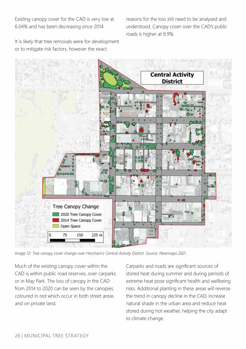
Existing canopy cover for the CAD is very low at 6.04% and has been decreasing since 2014.
It is likely that tree removals were for development or to mitigate risk factors, however the exact
Much of the existing canopy cover within the CAD is within public road reserves, over carparks or in May Park. The loss of canopy in the CAD from 2014 to 2020 can be seen by the canopies coloured in red which occur in both street areas and on private land.
Image 12: Tree canopy cover change over Horsham’s Central Activity District. Source: Nearmaps 2021.
reasons for the loss still need to be analysed and understood. Canopy cover over the CAD’s public roads is higher at 9.9%.
Carparks and roads are significant sources of stored heat during summer and during periods of extreme heat pose significant health and wellbeing risks. Additional planting in these areas will reverse the trend in canopy decline in the CAD, increase natural shade in the urban area and reduce heat stored during hot weather, helping the city adapt to climate change.

27 | MUNICIPAL TREE STRATEGY
STREET TREES There are an estimated 15,000 street trees within Horsham township, and an unknown amount in the other townships within the municipality.
The number of trees along rural roadsides is also unknown.
Research suggests that no single species should represent more than between 5-10% of an urban tree population, depending on the geographic region, rainfall and predominant land use types. This is to ensure adequate diversity to minimise the risks associated with monocultures or low diversity.
Table 3: 20 most common street trees in Horsham
Species Common Name No of trees % of pop
Pyrus calleryana Chanticleer 420 8.8%Eucalyptus camaldulensis River Red Gum 395 8.2%Eucalyptus microcarpa Grey Box 269 5.6%Lagerstroemia indica Crepe Myrtle 215 4.5%Ulmus parvifolia Chinese Elm Todd 214 4.5%Pistacia chinensis Chinese Pistachio 208 4.3%Pyrus calleryana Bradford Pear 205 4.3%Syzygium australe Pinnacle 155 3.2%Eucalyptus sideroxylon Red Ironbark 153 3.2%Eucalyptus torquate Coral Gum 148 3.1%Fraxinus angustifolia Desert Ash 138 2.9%Gleditsia triacanthos Honey Locust 137 2.9%Callistemon viminalis Weeping Bottlebrush 126 2.6%Eucalyptus cladocalyx Sugar Gum 123 2.6%Corymbia citriodora Lemon Scented Gum 121 2.5%Agonis flexuosa Willow Myrtle 106 2.2%Eucalyptus largiflorens Black Box 95 2.0%Eucalyptus leucoxylon Yellow Gum 88 1.8%Callistemon “Kings Park Special” Kings Park Bottlebrush 83 1.7%Pyrus calleryana Manchurian Pear 79 1.6%
Approximately one third of Horsham’s 15,000 street trees have been audited and data recorded on them. Of these trees:
• 4,798 have been spatially mapped and genus and species recorded
• 1,198 vacant tree planting sites have been mapped.
20 Most Common Street Trees
Of the 4,798 street trees with species recorded, the most commonly planted in streetscapes is Pyrus calleryana, the Chanticleer Ornamental Pear. There are multiple sub-types of this species planted throughout streetscapes representing a combined total of 14.5% of the audited tree population.
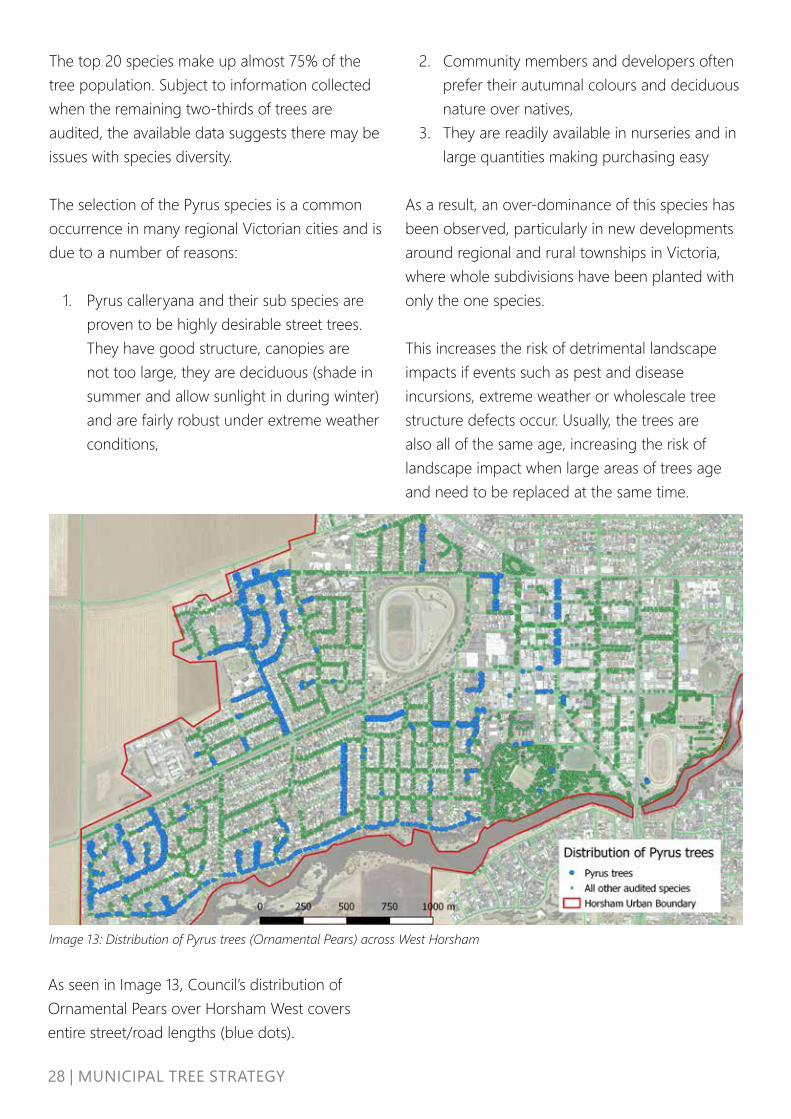
28 | MUNICIPAL TREE STRATEGY
Image 13: Distribution of Pyrus trees (Ornamental Pears) across West Horsham
The top 20 species make up almost 75% of the tree population. Subject to information collected when the remaining two-thirds of trees are audited, the available data suggests there may be issues with species diversity.
The selection of the Pyrus species is a common occurrence in many regional Victorian cities and is due to a number of reasons:
1. Pyrus calleryana and their sub species are proven to be highly desirable street trees. They have good structure, canopies are not too large, they are deciduous (shade in summer and allow sunlight in during winter) and are fairly robust under extreme weather conditions,
2. Community members and developers often prefer their autumnal colours and deciduous nature over natives,
3. They are readily available in nurseries and in large quantities making purchasing easy
As a result, an over-dominance of this species has been observed, particularly in new developments around regional and rural townships in Victoria, where whole subdivisions have been planted with only the one species.
This increases the risk of detrimental landscape impacts if events such as pest and disease incursions, extreme weather or wholescale tree structure defects occur. Usually, the trees are also all of the same age, increasing the risk of landscape impact when large areas of trees age and need to be replaced at the same time.
As seen in Image 13, Council’s distribution of Ornamental Pears over Horsham West covers entire street/road lengths (blue dots).
29 | MUNICIPAL TREE STRATEGY
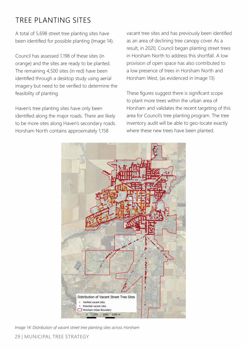
TREE PLANTING SITES A total of 5,698 street tree planting sites have been identified for possible planting (Image 14).
Council has assessed 1,198 of these sites (in orange) and the sites are ready to be planted. The remaining 4,500 sites (in red) have been identified through a desktop study using aerial imagery but need to be verified to determine the feasibility of planting.
Haven’s tree planting sites have only been identified along the major roads. There are likely to be more sites along Haven’s secondary roads. Horsham North contains approximately 1,158
Image 14: Distribution of vacant street tree planting sites across Horsham
vacant tree sites and has previously been identified as an area of declining tree canopy cover. As a result, in 2020, Council began planting street trees in Horsham North to address this shortfall. A low provision of open space has also contributed to a low presence of trees in Horsham North and Horsham West, (as evidenced in Image 13)
These figures suggest there is significant scope to plant more trees within the urban area of Horsham and validates the recent targeting of this area for Council’s tree planting program. The tree inventory audit will be able to geo-locate exactly where these new trees have been planted.

30 | MUNICIPAL TREE STRATEGY
REVIEW OF COUNCILS’ TREE MANAGEMENT PROGRAM
Trees are managed by the Council’s Operations’ team through both in-house works crews and contractors.
Council is currently in the process of developing a Tree Management Policy that will provide a framework for consistent decision making regarding tree planting, tree management and tree removal. TREE PLANTING AND SPECIES SELECTION Council plants 700-1000 urban trees per year in streets and parks and takes on approximately 100 street trees from developers each year. Species are usually selected based on stock availability in nurseries. Species are chosen to suit the identified planting sites and meet the required landscape function or value such as pedestrian walkways or biodiversity corridors.
Procuring quality stock is a challenge, due to the lack of local suppliers.
The annual tree planting plan, in part, is based on known vacant sites and customer requests. Council has been on a pathway to achieving change and has been undertaking whole street tree renewals by removing poorly performing species, especially those under powerlines and replanting the whole street to create avenues. Approximately six streets each year are completed through this whole of street approach.
To improve tree planting and species selection Council will:
• continue to plant trees through a two-year rolling tree planting and renewal program that considers:
a. Appropriate species selection for the site and future climate viability, including trialling of new species, seeking to diversify away from the use of Pyrus
b. Contract growing these trees to improve access to quality nursery stock
c. Improving the underground growing conditions e.g. passive infiltration of stormwater, trenching, mulching, access to adequate soil volumes where possible
d. Aligning and integrating with infrastructure planning works
e. Formal establishment program including formative pruning
f. Reducing the number of vacant sites to zero by 2031 by planting 560 more trees per year than are removed
g. Enhancing biodiversity outcomes along waterway corridors by focussing on indigenous species
h. Targeting areas that have been prioritised for tree planting
• Audit tree stock delivered from nursery so that it conforms to AS2303 - Tree Stock for Landscape Use
31 | MUNICIPAL TREE STRATEGY
TREE PROTECTION Public trees are protected where possible during Council infrastructure works such as road upgrades, footpath repairs and drainage works. Some trees are damaged by pests and disease, including damage done by corellas. Council’s arborists provide advice regarding root pruning, tree protection, tree removal and tree replanting.
Council trees are subject to tree protection during private development works but trees in subdivision developments can be damaged by contractors when new housing is built. Damaged trees are removed but not always replaced, depending on whether it is specified in the landscape plan. Council does not currently place a monetary or asset value on its trees nor use protection bonds as an incentive to protect trees during development. There is also a lack of resources that prevents tree protection measures from being enforced properly.
To improve overall tree protection Council will:
• Develop a Tree Management Policy that outlines protection measures to be taken
• Seek to develop and endorse a tree valuation method for Horsham.
• Enhance protection of street trees through the implementation of a bond over street or park trees that may be impacted by private development
• Seek additional resourcing to enforce the protection of Council trees from development works
• Prepare a Conservation Management Plan for the Botanical Gardens and apply the heritage overlay to ensure its protection
To improve canopy cover in new developments Council will:
• Provide education, guidance, incentives and best practice material for builders and developers to retain and protect existing trees in new developments, including early engagement at the concept stage.
• Develop landscape and /or subdivision design guidelines that become a key resource for developers who need to submit a landscape plan with a planning application. This will provide information and guidance on what needs to be submitted and landscape requirements, including tree protection and planting, which are in accordance with accepted industry and best practice standards. The guidelines should be tailored to the local climate and conditions and will also become a guide for Council staff on specifications that Council is willing to accept and/or approve at handover.
• Ensure permit applications for new developments are referred to all relevant units including Engineering, Recreation & Open Space, Statutory Planning and Strategic Planning.
TREES IN NEW DEVELOPMENTS Development over time is likely to have resulted in impacts to tree canopy cover in Horsham. Improved landscape design for new developments and greater availability of resources for developers can support increased tree canopy cover for emerging neighbourhoods and intensifying areas. Preserving existing trees where possible and planting new trees in new developments increases a development’s attractiveness, monetary value and marketability by providing aesthetic and functional values.

32 | MUNICIPAL TREE STRATEGY
TREE ESTABLISHMENT Newly planted trees are watered for three-years until established. Some formative pruning occurs but is not conducted on a scheduled, proactive basis. This means some trees are likely to develop structural issues requiring ongoing maintenance.
TREE REMOVAL Council removes approximately 100 trees per year. This is in response to community requests but is also part of an approach to remove undesirable species, in particular under power lines. There is currently no clear guideline or policy identifying a tree removal protocol and as a result, tree removal occurs on an ad-hoc basis.
TREE MAINTENANCE Maintenance of Horsham’s street and park trees has historically occurred as a result of customer requests or through Council’s annual inspection program of trees in high pedestrian or traffic areas. With no commensurate increase in the maintenance budget to reflect increased tree plantings, tree maintenance is based on customer requests and is reactive in nature. This exposes Council to risks of not proactively managing its assets.
Requests for rural roadside tree pruning are increasing, also without a commensurate increase in resources or funding. Farm machinery is increasing in size, requiring clearances along rural roads to be enlarged..
To improve tree establishment Council will:
• Develop and deliver rotational proactive tree maintenance program that includes formative pruning and establishment
To improve tree removal Council will: • Develop a Tree Management policy
with clear tree protection measures and guidelines for tree removal requests from the public and Council tree removals.
To improve tree maintenance Council will:
• Develop and deliver rotational proactive tree maintenance program that includes formative pruning and establishment
• Review and update the Roadside Vegetation Management Plan

33 | MUNICIPAL TREE STRATEGY
POWERLINE CLEARANCE Under the Electricity Safety (Electric Line Clearance) Regulations 2020 (Vic), Council is obligated to ensure that tree pruning provides adequate clearance for the safe operation of powerlines.
Council undertakes inspections and pruning works in the declared area of Horsham township. Council has also been undertaking a program of tree removals of inappropriate trees under powerlines and replacing trees with more appropriate species that will not conflict with the powerlines.
TREE DATA Only about a third of trees in the Horsham township are listed on a spatial tree inventory and of those, only some contain any specific data about the trees. As a result, Council does not have a comprehensive understanding of the extent or quality of its tree assets. A proactive maintenance program will only be possible when a full audit of trees has occurred.
TREES AS ASSETS Council does not currently apply a financial value to each tree asset.
Many other Council’s including Bendigo, Geelong, Shepparton and Wodonga utilise an amenity and/or environmental value to accurately inform costs for removal and replacement of trees. By attributing a dollar value to each tree asset, trees can form part of the cost benefit analysis for works designs and planning. A bond system can also be introduced as an incentive to protect trees during development or construction works.
To improve powerline clearance outcomes Council will:
• Continue to select the right species for each location
• Continue to remove and replace inappropriate species underneath powerlines
To improve the quality of tree data Council will:
• Undertake a tree inventory for all street and park trees in Horsham, Haven and Natimuk by a suitably qualified arborist
To improve recognition that trees are assets Council will:
• Seek to develop and endorse a tree valuation method for Horsham
• Implement the use of a bond over street or park trees to protect from development
• Include the tree inventory on Council’s asset management system

34 | MUNICIPAL TREE STRATEGY
WATER Very few of Council’s street and park trees are irrigated. There is capacity to improve conditions for trees, particularly in the Central Activity District by introducing irrigation and making better use of rainfall where it occurs, (e.g. through permeable pavement and local stormwater harvesting).
A variety of water options are available to support tree health and viability.
Some open spaces are irrigated using water stored in the network of wetlands located within the open spaces. This water storage has capacity to irrigate other areas. Extensions of Council’s existing stormwater reuse systems should be included in Council’s City to River planning, including extending an irrigation supply along Firebrace St.
GWM Water operates a recycled water facility but currently this is not connected to the Horsham township.
Council is licensed to extract water from the river and is currently not using the full water entitlement. These entitlements are subject to seasonal variability and drought. Water quality from the Wimmera River can also be problematic, with high salinity a factor that limits utilisation of this source in some years.
CAPITAL AND ASSET INFRASTRUCTURE WORKS Council’s Capital Works and Road Renewal teams consider tree protection during their works. If an opportunity to remove and replace poor tree specimens exists, the Operations Team will undertake the work.
Council projects are guided by an Infrastructure Design Manual that provides specifications for the construction of roads, footpaths, drainage works, and other works. Existing manuals do not provide guidance regarding the placement and installation of street trees or water sensitive urban design as part of the infrastructure works.
To improve availability of irrigation water for trees Council will:
• Explore use of alternative water sources (stormwater, river or recycled water) to irrigate high profile open space and associated trees
To improve capital and infrastructure works Council will:
• Develop technical drawings for tree planting typologies relevant to Horsham, including water sensitive urban design reflecting Horsham’s climate
• Review Council Infrastructure Design Manual and seek to update HRCC standard drawings to include space and consideration for street trees
• Ensure tree canopy targets are embedded in capital works and infrastructure renewal works
35 | MUNICIPAL TREE STRATEGY
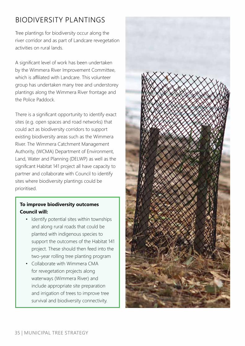
BIODIVERSITY PLANTINGS Tree plantings for biodiversity occur along the river corridor and as part of Landcare revegetation activities on rural lands.
A significant level of work has been undertaken by the Wimmera River Improvement Committee, which is affiliated with Landcare. This volunteer group has undertaken many tree and understorey plantings along the Wimmera River frontage and the Police Paddock.
There is a significant opportunity to identify exact sites (e.g. open spaces and road networks) that could act as biodiversity corridors to support existing biodiversity areas such as the Wimmera River. The Wimmera Catchment Management Authority, (WCMA) Department of Environment, Land, Water and Planning (DELWP) as well as the significant Habitat 141 project all have capacity to partner and collaborate with Council to identify sites where biodiversity plantings could be prioritised.
To improve biodiversity outcomes Council will:
• Identify potential sites within townships and along rural roads that could be planted with indigenous species to support the outcomes of the Habitat 141 project. These should then feed into the two-year rolling tree planting program
• Collaborate with Wimmera CMA for revegetation projects along waterways (Wimmera River) and include appropriate site preparation and irrigation of trees to improve tree survival and biodiversity connectivity.
36|MUNICIPALTREESTRATEGY
TREE REMOVAL, PROTECTION AND PLANTING ON PRIVATE LANDCouncil currently does not impose any regulation or Local Laws to protect trees or require the planting of trees on private property.
It is important to identify ways we can protect and enhance our private trees, especially those large healthy canopy trees that have taken decades to establish.
As a community we can assist Council in achieving canopy targets by:
• Protecting and caring for existing trees,• Planting new trees.
The regulation of tree protection and tree planting on private land has not been a focus for Council and we will need to explore a range of options if we are to address climate change and improve the amenity and liveability of our community.
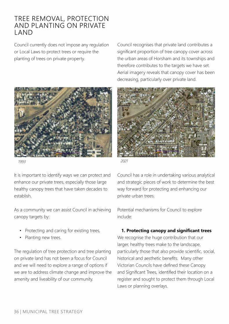
1993
20211993
Council recognises that private land contributes a significant proportion of tree canopy cover across the urban areas of Horsham and its townships and therefore contributes to the targets we have set. Aerial imagery reveals that canopy cover has been decreasing, particularly over private land.
Council has a role in undertaking various analytical and strategic pieces of work to determine the best way forward for protecting and enhancing our private urban trees.
Potential mechanisms for Council to explore include:
1. Protecting canopy and significant treesWe recognise the huge contribution that our larger, healthy trees make to the landscape, particularly those that also provide scientific, social, historical and aesthetic benefits. Many other Victorian Councils have defined these Canopy and Significant Trees, identified their location on a register and sought to protect them through Local Laws or planning overlays.

37 | MUNICIPAL TREE STRATEGY
2. Documenting Neighbourhood and Landscape Character
Trees and vegetation contribute to neighbourhood character values within the urban areas of Horsham. Tree canopy along streetscapes within the front and rear yards of properties makes a significant contribution to the amenity of neighbourhoods.
Council is about to undertake the development of a Housing Strategy, under which a Neighbourhood Character study will be undertaken. These documents will identify the current and future contribution that trees and canopy cover will make to neighbourhood character, and in doing so, provide an evidence base for planning changes to the protection and enhancement of trees in certain areas.
3. Tree Planting regulations in New Development and Subdivisions
New development and subdivisions present opportunities and challenges for trees in terms of their retention and protection, but also their replacement or introduction. There are already some requirements in the planning scheme requiring the retention or provision of trees in new development proposals, however there are opportunities to be more precise about canopy targets, reducing urban heat impacts associated with an increase in impervious surfaces and balancing built development with open public space requirements.
Horsham is experiencing relatively strong demand for new residential development, and this is expected to continue in the medium term. The Horsham Planning Scheme is currently being reviewed to identify gaps such as subdivision design and Environmentally Sustainable Design
(ESD), particularly as a response to the increasing impacts of climate change.
Increased best practice tree planting in developments can be addressed through the following sections of the Horsham Planning Scheme, for example:
• Subdivision Design• Environmentally Sustainable Design – yet to
be implemented by state government• Neighbourhood Character• Schedules to the Residential Zones• Tree protection overlays such as the
Environmental Significance Overlay, the Vegetation Protection Overlay and the Significant Landscape Overlay which all currently apply to some areas of Horsham.
Many Councils have modified their planning schedules to residential zones to specify a number of requirements in relation to landscaping, canopy tree provision, permeability, soil volume, etc. which assist in ensuring adequate tree retention and provision when development occurs. In determining Council’s commitment to progressing tree protection and enhancement in the private realm, it is acknowledged that the on-ground implementation of this Strategy and associated policy will focus on public land owned or managed by Council.
This Strategy however provides the basic platform to raise these issues and explore further work reviewing the appropriate mechanisms (e.g. Local Laws and the Horsham Planning Scheme) to address tree canopy retention and protections on private land.

38 | MUNICIPAL TREE STRATEGY
The work will be undertaken by Council’s Strategic Planning Team. The work will assist the municipality to not only meet tree canopy targets more quickly but also more fully realise the potential public health, wellbeing, environmental, social and economic benefits from a holistic approach to Council’s urban tree canopy targets.
Council will explore the protection and enhancement of trees on private land by:
• Further analysing the high-resolution tree canopy data to quantify the losses of tree cover on private land and seek to understand the main causes and solutions
• Encouraging private landholders to protect existing trees and plant new ones on their land
• Developing an appropriate policy to address the protection of significant and canopy trees on private land and explore appropriate regulatory mechanisms to enforce the policy
• Exploring the feasibility of creating a Significant Tree Register and associated protections
• Undertaking strategic work such as the Neighbourhood Character Assessment
• Investigating as part of the Planning Scheme Review the shortfalls of the Planning Scheme in terms of tree provision and protection and undertake the strategic work to inform local planning policy and planning scheme requirements to ensure new developments protect existing large trees and where lacking establish new canopy trees, strengthening the tree canopy provision in the private realm.
• Developing a suite of education, guidance and best practice material for builders and developers to retain and protect existing trees in new developments, including early engagement at the concept stage

39 | MUNICIPAL TREE STRATEGY
CULTURALLY SIGNIFICANT TREESHorsham is home to an array of culturally significant trees. There is currently insufficient information regarding their location, health status and the absence of a framework to adequately protect trees of significance.
To improve outcomes for culturally significant trees Council will:
• Map culturally significant trees on Council owned land for planning and internal purposes. This work would need to be undertaken in consultation with BGLC ensuring cultural sensitivity is respected and maintained and to ensure greater protection and management practices are implemented in Horsham’s Planning Scheme.
• Where appropriate, include these trees in a Significant Tree Register that is protected through appropriate regulation that ensures protection.
• Partner with BGLC for tree planning along waterways, an area of sensitivity for Traditional Owners, and around other key sites
(Note: input into this section is being sought from BGLC and will be re-edited once this input is provided)

40 | MUNICIPAL TREE STRATEGY
CHALLENGESAND OPPPORTUNITIESCouncil has identified some key challenges facing its urban and rural roadside trees and the way in which they are currently managed. To achieve our vision and targets, we need to understand and overcome these challenges.
CLIMATE CHANGEClimate change will impact on the health and wellbeing of Horsham’s community, and the health of our urban and rural roadside trees in a number of ways. Annual average temperatures will increase, the frequency of heatwaves will increase, and there will be more extreme weather events and lower average rainfall.
The impacts of climate change on our urban and rural roadside trees include:
• The susceptibility of vegetation to increasing and emerging pests and diseases, challenging their ability to withstand and recover from these outbreaks,
• Extreme weather events such as storms, drought, bushfire and floods, leading to a reduction and overall decline in health of canopy cover,
• Lower rainfall will increase the frequency of tree death in many species and contribute to overall tree health decline,
To overcome the challenges of climate change, Council will:
• Ensure appropriate species selection for each site and future climate viability, including trialling of new species
• Improve the underground growing conditions for newly planted trees where possible e.g. passive infiltration of stormwater, trenching, mulching, access to adequate soil volumes
• Develop technical drawings for tree planting typologies relevant to Horsham, including water sensitive urban design
• Consider Water Sensitive Urban Design (WSUD) treatments as standard practice
• A number of the existing species that have been planted may not be tolerant of increased heat and will die or fail to thrive e.g. some of the exotic species planted in the Botanic Gardens.
Species selection for a changing climate will be critical to ensure the ongoing health and viability of urban trees so they maximise their benefits into the future. Council is already trialling new species that are likely to thrive under climate change and will continue to adapt its planting palette to ensure only resilient species are planted.
This list will continue to be utilised by Council, developers, other government agencies and community groups.

41 | MUNICIPAL TREE STRATEGY
Image 15: Some of the mature specimens in the Horsham Botanic Gardens were planted last century and are showing signs of stress and senescence such as the mature stand of Elm trees. Climate change requires Council to choose species which will be suitable for replanting into the future while acknowledging the existing aesthetic and character of high value species
42 | MUNICIPAL TREE STRATEGY
URBAN HEAT The urban heat island effect increases the overall temperature of urban areas that have an abundance of hard surfaces. The effect is exacerbated during heat waves when night-time temperatures remain high and hard surfaces cannot cool down. Trees and vegetation mitigate this effect by cooling the urban environment through a process call evapotranspiration. Supplying water to vegetation increases their cooling potential, especially for trees.
Planting more trees and vegetation across the urban areas of Horsham and irrigating through either alternative sources or passive stormwater infiltration will provide a cooler urban environment, particularly during summer. This canopy shade should be prioritised for areas of need where social vulnerability to heat is greatest.
Horsham’s township is expected to grow over time, increasing impervious surfaces such as buildings, roads and other infrastructure and increasing urban heat impacts. It is essential that we consider stronger development requirements for the retention of established trees and the provision of new trees to help mitigate this heat and reduce the impact on liveability and human health.
DATA AND IT ISSUES
To overcome the challenges of urban heat impacts Council will:
• Explore use of alternative water sources (stormwater, river or recycled water) to irrigate high profile open space and associated trees
• Increase supplementary irrigation to CAD trees to improve overall health and growth
• Collaborate with WCMA for revegetation projects along waterways (Wimmera River) and other areas and irrigate the trees to improve biodiversity connectivity
• Develop technical drawings for tree planting typologies relevant to Horsham, including water sensitive urban design
• Continue to plant trees through a two-year rolling tree planting and renewal program
• Educate the community and encourage property owners to plant trees in order to increase the overall canopy cover of Horsham
• Advocate for changes to Clause 56 to ensure climate responsive landscape design to support the provision of canopy trees and help reduce the impact of urban heat in the public realm

43 | MUNICIPAL TREE STRATEGY
Council does not have a comprehensive tree inventory nor a fit for purpose tree asset database system. The absence of data and an effective electronic management system prevents the opportunity to view trees as an asset, appropriately manage their risk profile, place a value on trees or adequately budget for their sustainable management. Investing in an evidence-based tree asset dataset and housing it within a functional database system will enable new data capture, analysis of existing data, recording works and integrating activity relating to trees and their management across different work areas.
Tree data could also be integrated with other Council asset data and programming to help prioritise areas for tree planting, tree protection and maintenance.
To overcome data and IT issues Council will:
• Undertake a tree inventory for all street and park trees in Horsham, Haven and Natimuk
• Explore an alternative tree asset database system that is fit for purpose
• Develop cost benefit analysis for street and park trees and include in asset planning. Showcase the value of trees as an appreciating asset
• Ensure tree planning to align with road reconstruction works

44 | MUNICIPAL TREE STRATEGY
To overcome reactive management issues Council will:
• Analyse the tree inventory, once captured, to identify the extent of maintenance works required to minimise known risks
• Develop and deliver a rotational proactive tree maintenance program that includes formative pruning and establishment. This will require an increase in resources and budget however the outcome of this initial investment will be a strategically and proactively managed tree asset requiring less ongoing maintenance and reduced budget over the lifetime of each tree.
• Implement a formal establishment program including formative pruning as part of the tree planting program
REACTIVE ASSET MANAGEMENTBecause of the volume of customer requests and existing budgets and resources, the tree maintenance program is largely reactive. The Local Government Act (2020) requires Local Government Authorities (LGAs) to develop an Asset Management Plan documenting information specifying the activities, resources and timescales required for an individual asset or a grouping of assets. Council does not currently treat trees as assets and hence, does not have a tree asset management plan.
In 2011, the Municipal Association of Victoria’s (MAV) insurance arm reviewed the status of Horsham Rural City Council’s tree management program. The MAV concluded that Council should, at a minimum:
1. Formalise the reactive (customer request) maintenance program
2. Review the street tree policy and include a detailed ongoing strategy for programmed maintenance, planting and allocation of resources with consideration of risk.
3. Prioritise proactive inspections and maintenance
4. Develop a tree inventory
As of mid-2021, none of the MAV recommendations have been implemented.
Coroners’ inquests into tree related deaths reinforce the need for LGAs to have an appropriate understanding and management of risk in relation to their tree assets.
While there is no legal requirement to do so, a transition towards a proactive tree management program that better manages risk as well as improving the overall health, vigour and structure of the tree population will bring a wealth of benefits including better management of asset risk while reducing the amount and cost of reactive maintenance over time.
45 | MUNICIPAL TREE STRATEGY
Community engagement methods being used by other Councils include:
• Tree tags on newly planted trees explaining the role of the individual tree in contributing to the broader tree population.
• Developing precinct plans in collaboration with the community to identify where and what species of tree should be planted over a 10-year period.
• Developing on open-source data platform for the community to see the tree and canopy cover data relevant to their area
• Community tree planting days and tree giveaways.
PERCEPTION OF TREES Interaction with the community on tree matters is varied and highly emotive.
From vandalism of young trees and culturally significant trees through to backlash about the removal of large trees, concerns regarding trees generate a significant number of complaints from the community to Council. There is an acknowledgement that Council could improve its communication regarding plans for large tree removals and replacements.
Council also has an opportunity to improve the understanding and awareness within the community about the benefits of our trees.
A range of communication methods, materials and protocols can be adopted to raise awareness of the benefits of urban trees. They could also identify appropriate species for the Horsham region, describe how to look after newly planted trees and detail the processes for tree protection and tree removal, including enforcement measures. Improved communication strategies could be used within Council and the wider community and be available to developers and contractors.
To increase positive perceptions of trees Council will:
• Develop a community engagement program to increase access to knowledge and information in partnership with BGLC
• Run community tree planting days with youth and community groups
• Explore the possibility of reinstating the Walking Trees tour developed by the community.
• Develop clear messaging about the benefits of tree assets and provide this information to work crews who interact with the community
• Develop and make available best practice guides and case studies for developers
46|MUNICIPALTREESTRATEGY
INFRASTRUCTURE CONFLICTAs a result of historical poor species selection and traditional streetscape design, Horsham is managing a legacy of conflicts between infrastructure and trees.
Powerline clearance requirements and the physical impact on drainage and road infrastructure leads to tree removals and infrastructure repair and reconstruction. Trees are replaced where possible, but because of existing infrastructure issues, replacement of trees is not consistent.
As the need increases for our public realm to provide many functions, engineered and designed solutions for dealing with these conflicts are increasingly being developed and applied.
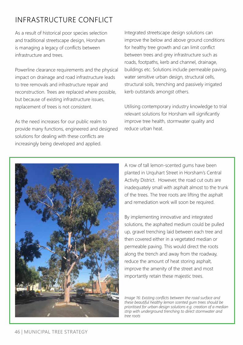
Image 16: Existing conflicts between the road surface and these beautiful healthy lemon scented gum trees should be prioritised for urban design solutions e.g. creation of a median strip with underground trenching to direct stormwater and tree roots
A row of tall lemon-scented gums have been planted in Urquhart Street in Horsham’s Central Activity District. However, the road cut outs are inadequately small with asphalt almost to the trunk of the trees. The tree roots are lifting the asphalt and remediation work will soon be required.
By implementing innovative and integrated solutions, the asphalted medium could be pulled up, gravel trenching laid between each tree and then covered either in a vegetated median or permeable paving. This would direct the roots along the trench and away from the roadway, reduce the amount of heat storing asphalt, improve the amenity of the street and most importantly retain these majestic trees.
Integrated streetscape design solutions can improve the below and above ground conditions for healthy tree growth and can limit conflict between trees and grey infrastructure such as roads, footpaths, kerb and channel, drainage, buildings etc. Solutions include permeable paving, water sensitive urban design, structural cells, structural soils, trenching and passively irrigated kerb outstands amongst others.
Utilising contemporary industry knowledge to trial relevant solutions for Horsham will significantly improve tree health, stormwater quality and reduce urban heat.

47 | MUNICIPAL TREE STRATEGY
To overcome infrastructure conflict issues Council will:
• Develop technical drawings for tree planting typologies relevant to Horsham, including water sensitive urban design
• Develop pilot projects within the CAD Revitalisation project that showcase use of innovative design solutions e.g. trenching, water sensitive urban design, permeable paving
• Develop a framework for resolving claims of tree damage to private infrastructure
• Identify all opportunities to plant trees in road reserve instead of back of kerb
• Utilise masterplans, streetscape plans, structure plans or urban design frameworks, to ensure canopy trees are strategically planted to increase shade and amenity along walking routes and identified public spaces
• Engage with servicing authorities at the concept stage and planning permit stage of new developments to plan for the consolidation of existing / planned assets that will enable sufficient space for the planting of canopy trees in new subdivisions.
48 | MUNICIPAL TREE STRATEGY
INTEGRATED PLANNING AND DEVELOPMENTUrban regeneration and development create change that not only impacts on existing trees but also creates opportunities to increase greening and liveability.
Currently in Horsham, trees are generally not viewed as integral elements of the urban landscape, leading to lost opportunities for creating shade and improving the urban character.
Trees need to be regarded as a fundamental and valuable public asset, as roads and footpaths are, to be considered and incorporated into the planning stages for all works undertaken by Council or resulting from development or major infrastructure projects. This involves incorporating trees into Council’s asset register with trees being valued according to their contribution to the landscape and to community health and wellbeing. Trees must also be recognised as an appreciating asset that delivers multi-functional environmental, social and economic benefits that increase in value over time.
in new development and ensure these guidelines are adopted and actively used by the relevant Council units.
• Provide education and guidance for builders and developers to retain and protect existing trees in new developments
• Seek opportunities for Water Sensitive Urban Design (WSUD) to passively irrigate trees within the context of Horsham’s climate
• Develop guidelines for developers to provide the detail on how trees should be selected, planted and maintained in subdivisions. Implementation should include:
o Street Tree Planting process and species list o Maintenance Standards and Responsibility, o Public Open Space landscape standards o Tree Protection standards• Ensure any Council led work whether
plans, capital works or development projects embed and support the tree canopy targets
• Develop cost benefit analysis for street and park trees and include in asset planning.
• Ensure tree planting is an integral component of road reconstruction works
• Establish internal processes for responding to planning referrals that should be directed to Recreation & Open Space and Infrastructure Services.
To overcome the lack of integrated planning Council will:
• Review Council Infrastructure Design Manual and seek to update Council’s standard drawings to include space and consideration for street trees
• Engage early with developers at the concept stage to encourage tree planting and the integration of existing trees in new subdivisions
• Develop Council landscape guidelines that address street trees, lineal paths, public open space and urban forests

49 | MUNICIPAL TREE STRATEGY
STRATEGICALLY PLANTING TREES IN AREAS OF NEEDCurrently, trees are planted as a result of customer requests, in line with the road rehabilitation program or where Council has undertaken strategic re-planting, e.g. removal of inappropriate species under power lines.
While whole street plantings make maintenance more efficient and streamlined, there are areas of Horsham where priority tree plantings are needed to improve shade cover for pedestrians, local amenity, reduce urban heat impacts and buffer areas of biodiverse value. With more than 5,600 vacant tree planting sites currently available and Council’s current capacity limited to planting approximately 700-900 trees each year, it is important to prioritise tree planting.
Without comprehensive and accurate data available, it is difficult to develop an evidence-based tree planting plan. Council is currently developing a number of documents and projects that will inform priority tree planting locations. When these are finalised and priority locations are identified, the plans will directly inform the rolling two-year tree planting plan.
Using the spatial mapping provided via analytical tools (Nearmap), consultation with Council staff currently developing urban design frameworks and precinct plans, and advice from external agencies including the Wimmera Catchment Management Authority, the following areas of Horsham have been identified as broad priority areas for tree planting:
1. Horsham North (currently already the target area for the tree planting program)
2. Open space/parks generally3. Streets leading to open space4. Gateway roads5. Central Activity District6. River Corridor
The development of a detailed tree inventory and associated data sets such as social census-based social vulnerability data or biodiversity information along with further strategic work will further inform future priority planting locations throughout the municipality.
50 | MUNICIPAL TREE STRATEGY
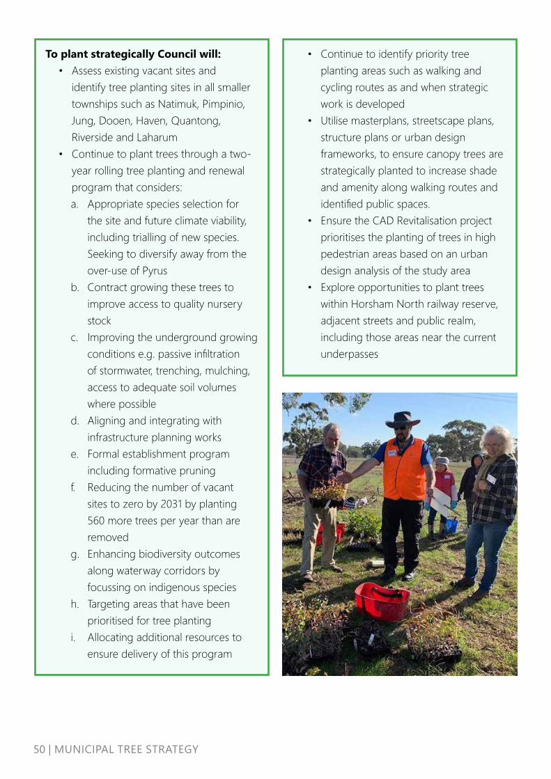
To plant strategically Council will: • Assess existing vacant sites and
identify tree planting sites in all smaller townships such as Natimuk, Pimpinio, Jung, Dooen, Haven, Quantong, Riverside and Laharum
• Continue to plant trees through a two-year rolling tree planting and renewal program that considers: a. Appropriate species selection for
the site and future climate viability, including trialling of new species. Seeking to diversify away from the over-use of Pyrus
b. Contract growing these trees to improve access to quality nursery stock
c. Improving the underground growing conditions e.g. passive infiltration of stormwater, trenching, mulching, access to adequate soil volumes where possible
d. Aligning and integrating with infrastructure planning works
e. Formal establishment program including formative pruning
f. Reducing the number of vacant sites to zero by 2031 by planting 560 more trees per year than are removed
g. Enhancing biodiversity outcomes along waterway corridors by focussing on indigenous species
h. Targeting areas that have been prioritised for tree planting
i. Allocating additional resources to ensure delivery of this program
• Continue to identify priority tree planting areas such as walking and cycling routes as and when strategic work is developed
• Utilise masterplans, streetscape plans, structure plans or urban design frameworks, to ensure canopy trees are strategically planted to increase shade and amenity along walking routes and identified public spaces.
• Ensure the CAD Revitalisation project prioritises the planting of trees in high pedestrian areas based on an urban design analysis of the study area
• Explore opportunities to plant trees within Horsham North railway reserve, adjacent streets and public realm, including those areas near the current underpasses

51 | MUNICIPAL TREE STRATEGY
Image 17: Priority areas to consider for the annual tree planting program

52 | MUNICIPAL TREE STRATEGY
A series of actions, including six headline actions have been identified to guide investment in Council’s trees. These actions reflect the key objectives of our tree management program:
1. Protect and Enhance2. Increase Tree Canopy3. Improve character and biodiversity4. Educate and engage5. Deliver best practice6. Celebrate cultural heritage
HEADLINE ACTIONS
1. Undertake a detailed inventory of all street and park trees within Horsham, Haven and Natimuk.
2. Develop a 5-year program of proactive tree maintenance work that seeks to improve the overall health, structure and viability of all existing trees.
3. Continue to plant trees through a two-year rolling tree planting and renewal program that considers: a. Appropriate species selection for the site
and future climate viability, including trialling of new species. Seeking to diversify away from the use of Pyrus,
b. Contract growing these trees to improve access to quality nursery stock,
c. Improving the underground growing conditions e.g. passive infiltration of stormwater, trenching, mulching, access to adequate soil volumes where possible,
IMPLEMENTATIONd. Aligning and integrating with
infrastructure planning works,e. Formal establishment program including
formative pruning,f. Reducing the number of vacant sites to
zero by 2031 by planting 560 more trees per year than are removed,
g. Enhancing biodiversity outcomes along waterway corridors by focussing on indigenous species,
h. Targeting areas that have been prioritised for tree planting.4. Improve the way in which Council interacts
with the community regarding trees: improve access to knowledge and information, improve transparency of programs, collaborate with groups seeking to be involved and encourage private landholders to care for and plant more trees on their own land
5. Ensure that the upcoming Planning Scheme Review reflects the issues identified in the Tree Strategy, particularly the role that private trees play and how we can better protect and enhance them:a. Explore the development of a Significant
Tree Register, identify Council trees that require enhanced protection and identify the most appropriate regulatory mechanism for their protection,
b. Investigate measures to protect trees on private land from unnecessary removal and ensure that trees are planted (or replaced) during the appropriate stages of subdivision and/or development,
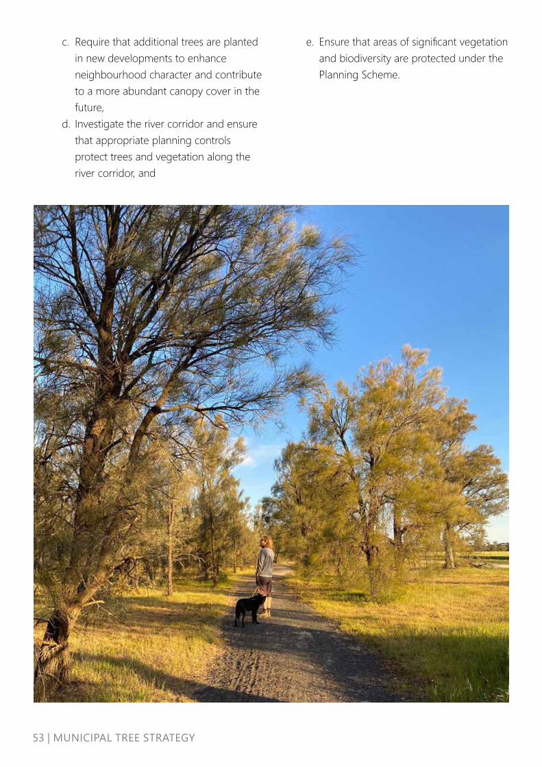
53 | MUNICIPAL TREE STRATEGY
c. Require that additional trees are planted in new developments to enhance neighbourhood character and contribute to a more abundant canopy cover in the future,
d. Investigate the river corridor and ensure that appropriate planning controls protect trees and vegetation along the river corridor, and
e. Ensure that areas of significant vegetation and biodiversity are protected under the Planning Scheme.

54 |
MU
NIC
IPAL
TRE
E ST
RATE
GY
IMPL
EMEN
TATI
ON
ACT
ION
SO
bjec
tive
Out
com
eTi
mef
ram
eBu
dget
Resp
onsi
bilit
y
1. P
rote
ct
and
Enha
nce
1.1
Und
erta
ke tr
ee in
vent
ory
for a
ll st
reet
and
par
k tr
ees
in H
orsh
am, H
aven
and
Nati
muk
Deta
iled
data
on
the
tree
as
set
Shor
t$$
$Pa
rks a
nd G
arde
ns, R
ec a
nd O
pen
Spac
e
1.2
Deve
lop
Tree
Man
agem
ent p
olic
y w
ith c
lear
tree
pr
otec
tion
mea
sure
s and
gui
delin
es fo
r tre
e re
mov
al
from
cus
tom
er re
ques
ts, d
evel
opm
ent a
nd C
ounc
il w
orks
Bette
r pr
otec
ted
tree
s Sh
ort
$Pa
rks a
nd G
arde
ns, R
ec a
nd O
pen
Spac
e
1.3
Deve
lop
and
deliv
er ro
tatio
nal p
roac
tive
tree
m
aint
enan
ce p
rogr
am th
at in
clud
es fo
rmati
ve p
runi
ng
and
esta
blish
men
t
Incr
ease
d he
alth
, ULE
an
d st
ruct
ure
of tr
ee a
sset
Shor
t/M
ediu
m$$
$Pa
rks a
nd G
arde
ns
1.4
Revi
ew a
nd u
pdat
e th
e Ro
adsid
e Ve
geta
tion
Man
agem
ent P
lan
Docu
men
ted
prot
ocol
s Sh
ort/
Med
ium
$Pa
rks a
nd G
arde
ns
1.5
Revi
ew n
atur
e st
rip g
uide
lines
and
seek
to re
mov
e la
ndsc
ape
type
s tha
t hin
der s
tree
t tre
e gr
owth
Bette
r gro
win
g co
nditi
ons f
or
stre
et tr
ees
Shor
t/M
ediu
m$
Park
s and
Gar
dens
1.6
Expl
ore
the
crea
tion
of a
Sig
nific
ant T
ree
Regi
ster
that
se
eks t
o pr
otec
t tre
es o
f ide
ntifie
d sig
nific
ance
and
co
nsid
er th
e m
ost a
ppro
pria
te re
gula
tory
pro
tecti
on
mec
hani
sms.
Util
ise tr
ee in
vent
ory
resu
lts to
iden
tify
signi
fican
t tre
es o
n pu
blic
land
Sign
ifica
nt T
ree
Regi
ster
Shor
t/M
ediu
m$
Stra
tegi
c Pl
anni
ng/ P
arks
and
Gar
dens
1.7
Seek
to d
evel
op a
nd e
ndor
se a
stre
et a
nd p
ark
tree
va
luati
on m
etho
d fo
r Hor
sham
Tree
s are
giv
en
finan
cial
val
ues
Med
ium
$As
sets
/ Fin
ance
1.8
Enha
nce
prot
ectio
n of
stre
et tr
ees t
hrou
gh th
e im
plem
enta
tion
of a
bon
d ov
er st
reet
or p
ark
tree
s th
at m
ay b
e im
pact
ed b
y pr
ivat
e de
velo
pmen
t
Tree
s are
va
lued
ass
ets
Med
ium
$$St
atut
ory
Plan
ning
1.9
Seek
add
ition
al re
sour
cing
to e
nfor
ce th
e pr
otec
tion
of tr
ees a
nd th
e pl
antin
g of
tree
s on
deve
lopm
ent
sites
and
new
subd
ivisi
ons.
Tree
s are
pr
otec
ted
Shor
t$$
Park
s and
Gar
dens
and
Ass
et M
anag
emen
t Tea
m
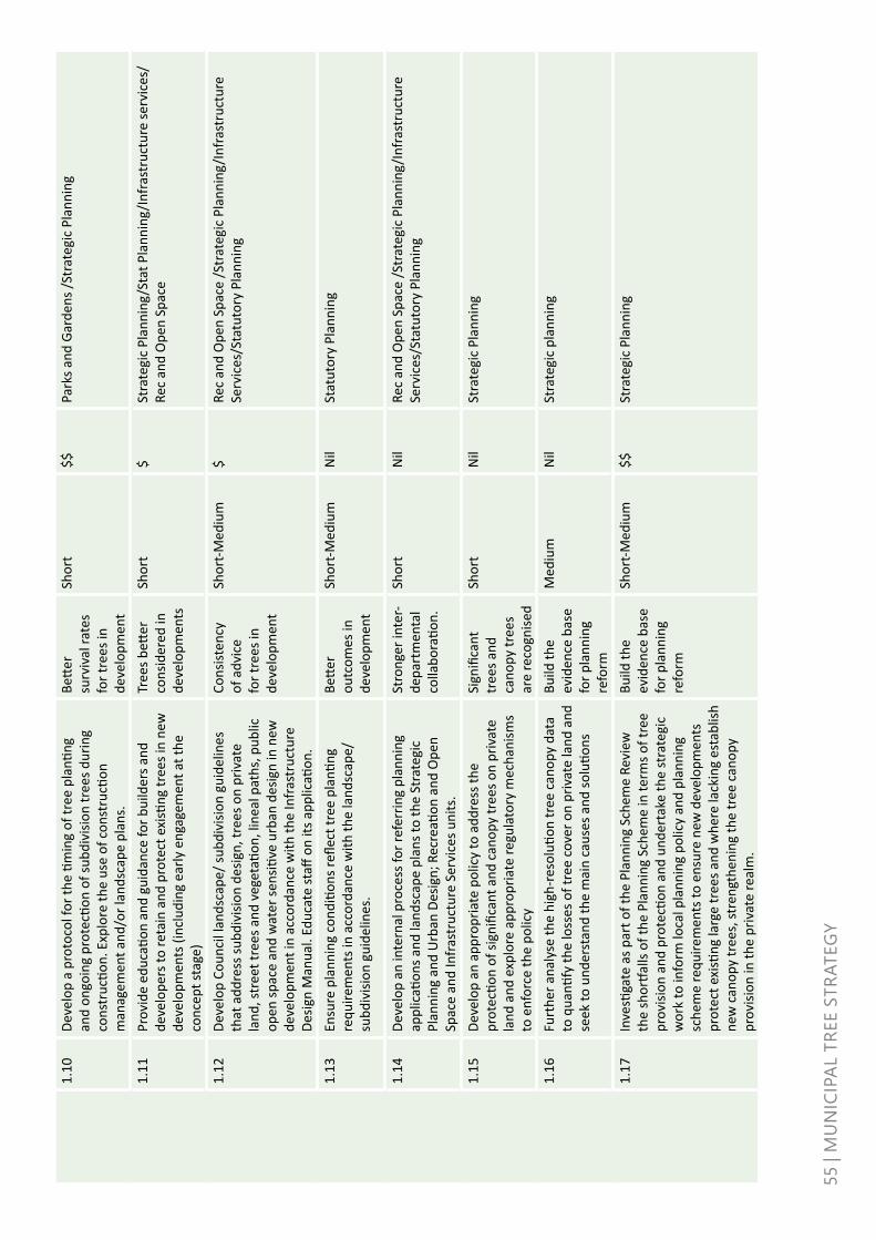
55 |
MU
NIC
IPAL
TRE
E ST
RATE
GY
1.10
Deve
lop
a pr
otoc
ol fo
r the
tim
ing
of tr
ee p
lanti
ng
and
ongo
ing
prot
ectio
n of
subd
ivisi
on tr
ees d
urin
g co
nstr
uctio
n. E
xplo
re th
e us
e of
con
stru
ction
m
anag
emen
t and
/or l
ands
cape
pla
ns.
Bette
r su
rviv
al ra
tes
for t
rees
in
deve
lopm
ent
Shor
t$$
Park
s and
Gar
dens
/Str
ateg
ic P
lann
ing
1.11
Prov
ide
educ
ation
and
gui
danc
e fo
r bui
lder
s and
de
velo
pers
to re
tain
and
pro
tect
exi
sting
tree
s in
new
de
velo
pmen
ts (i
nclu
ding
ear
ly e
ngag
emen
t at t
he
conc
ept s
tage
)
Tree
s bett
er
cons
ider
ed in
de
velo
pmen
ts
Shor
t$
Stra
tegi
c Pl
anni
ng/S
tat P
lann
ing/
Infr
astr
uctu
re se
rvic
es/
Rec
and
Ope
n Sp
ace
1.12
Deve
lop
Coun
cil l
ands
cape
/ sub
divi
sion
guid
elin
es
that
add
ress
subd
ivisi
on d
esig
n, tr
ees o
n pr
ivat
e la
nd, s
tree
t tre
es a
nd v
eget
ation
, lin
eal p
aths
, pub
lic
open
spac
e an
d w
ater
sens
itive
urb
an d
esig
n in
new
de
velo
pmen
t in
acco
rdan
ce w
ith th
e In
fras
truc
ture
De
sign
Man
ual.
Educ
ate
staff
on
its a
pplic
ation
.
Cons
isten
cy
of a
dvic
e fo
r tre
es in
de
velo
pmen
t
Shor
t-Med
ium
$Re
c an
d O
pen
Spac
e /S
trat
egic
Pla
nnin
g/In
fras
truc
ture
Se
rvic
es/S
tatu
tory
Pla
nnin
g
1.13
Ensu
re p
lann
ing
cond
ition
s refl
ect t
ree
plan
ting
requ
irem
ents
in a
ccor
danc
e w
ith th
e la
ndsc
ape/
su
bdiv
ision
gui
delin
es.
Bette
r ou
tcom
es in
de
velo
pmen
t
Shor
t-Med
ium
Nil
Stat
utor
y Pl
anni
ng
1.14
Deve
lop
an in
tern
al p
roce
ss fo
r ref
errin
g pl
anni
ng
appl
icati
ons a
nd la
ndsc
ape
plan
s to
the
Stra
tegi
c Pl
anni
ng a
nd U
rban
Des
ign;
Rec
reati
on a
nd O
pen
Spac
e an
d In
fras
truc
ture
Ser
vice
s uni
ts.
Stro
nger
inte
r-de
part
men
tal
colla
bora
tion.
Shor
tN
ilRe
c an
d O
pen
Spac
e /S
trat
egic
Pla
nnin
g/In
fras
truc
ture
Se
rvic
es/S
tatu
tory
Pla
nnin
g
1.15
Deve
lop
an a
ppro
pria
te p
olic
y to
add
ress
the
prot
ectio
n of
sign
ifica
nt a
nd c
anop
y tr
ees o
n pr
ivat
e la
nd a
nd e
xplo
re a
ppro
pria
te re
gula
tory
mec
hani
sms
to e
nfor
ce th
e po
licy
Sign
ifica
nt
tree
s and
ca
nopy
tree
s ar
e re
cogn
ised
Shor
tN
ilSt
rate
gic
Plan
ning
1.16
Furt
her a
naly
se th
e hi
gh-r
esol
ution
tree
can
opy
data
to
qua
ntify
the
loss
es o
f tre
e co
ver o
n pr
ivat
e la
nd a
nd
seek
to u
nder
stan
d th
e m
ain
caus
es a
nd so
lutio
ns
Build
the
evid
ence
bas
e fo
r pla
nnin
g re
form
Med
ium
Nil
Stra
tegi
c pl
anni
ng
1.17
Inve
stiga
te a
s par
t of t
he P
lann
ing
Sche
me
Revi
ew
the
shor
tfalls
of t
he P
lann
ing
Sche
me
in te
rms o
f tre
e pr
ovisi
on a
nd p
rote
ction
and
und
erta
ke th
e st
rate
gic
wor
k to
info
rm lo
cal p
lann
ing
polic
y an
d pl
anni
ng
sche
me
requ
irem
ents
to e
nsur
e ne
w d
evel
opm
ents
pr
otec
t exi
sting
larg
e tr
ees a
nd w
here
lack
ing
esta
blish
ne
w c
anop
y tr
ees,
stre
ngth
enin
g th
e tr
ee c
anop
y pr
ovisi
on in
the
priv
ate
real
m.
Build
the
evid
ence
bas
e fo
r pla
nnin
g re
form
Shor
t-Med
ium
$$St
rate
gic
Plan
ning

56|MUNICIPALTREESTRATEGY
1.18
Advo
cate
for c
hang
es to
Cla
use
56 to
ens
ure
clim
ate
resp
onsiv
e la
ndsc
ape
desig
n to
supp
ort t
he p
rovi
sion
of c
anop
y tr
ees a
nd h
elp
redu
ce th
e im
pact
of u
rban
he
at in
the
publ
ic re
alm
Stre
ngth
en
Hors
ham
Pl
anni
ng
Sche
me
Med
ium
$$St
rate
gic
Plan
ning
1.19
Enga
ge w
ith se
rvic
ing
auth
oriti
es a
t the
con
cept
stag
e an
d pl
anni
ng p
erm
it st
age
of n
ew d
evel
opm
ents
to
plan
for t
he c
onso
lidati
on o
f exi
sting
/ pl
anne
d as
sets
th
at w
ill e
nabl
e su
ffici
ent s
pace
for t
he p
lanti
ng o
f ca
nopy
tree
s in
new
subd
ivisi
ons.
Impr
oved
co
llabo
ratio
n fo
r the
pl
anni
ng o
f tr
ees.
Shor
tN
ilEx
tern
al p
artn
ers &
stak
ehol
ders
1.20
Prep
are
a Co
nser
vatio
n M
anag
emen
t Pla
n fo
r the
Bo
tani
cal G
arde
ns a
nd a
pply
the
herit
age
over
lay
to
ensu
re it
s pro
tecti
on
Prot
ectio
n fo
r Bot
anic
al
Gard
ens
Shor
t$$
Park
s & G
arde
ns/S
trat
egic
Pla
nnin
g
1.21
Seek
fund
ing
oppo
rtun
ities
to re
stor
e / e
nhan
ce
aven
ues o
f hon
our.
Rene
wal
of
her
itage
la
ndsc
apes
Med
ium
$$
(gra
nt)
Park
s & G
arde
ns/S
trat
egic
Pla
nnin
g
1.22
Cons
ider
pla
nnin
g m
echa
nism
s bes
t sui
ted
for t
he
prot
ectio
n an
d re
tenti
on o
f exi
sting
woo
dlan
d tr
ees i
n Ha
ven
that
con
trib
ute
to th
e liv
eabi
lity
and
char
acte
r of
the
area
Sign
ifica
nt
tree
s and
ca
nopy
tree
s ar
e re
cogn
ised
Med
ium
Nil
Stra
tegi
c Pl
anni
ng
2. In
crea
se
tree
can
opy
cove
r
2.1
Grou
nd tr
uth
existi
ng v
acan
t site
s and
iden
tify
tree
pl
antin
g sit
es in
all
smal
ler t
owns
hips
such
as N
atim
uk,
Pim
pini
o, Ju
ng, D
ooen
, Hav
en, Q
uant
ong,
Riv
ersid
e an
d La
haru
m
Tree
pla
nting
op
port
uniti
es
iden
tified
Shor
tEx
isting
Park
s and
Gar
dens
2.2
Conti
nue
to id
entif
y pr
iorit
y tr
ee p
lanti
ng a
reas
such
as
wal
king
and
cyc
ling
rout
es a
s and
whe
n st
rate
gic
wor
k is
deve
lope
d
Prio
rity
tree
pl
antin
g sit
es
iden
tified
Shor
t$$
Rec
and
Ope
n Sp
ace
/ Sta
tuto
ry P
lann
ing
2.3
Deve
lop
a 2-
year
rolli
ng tr
ee p
lanti
ng a
nd re
new
al
prog
ram
Tree
s pla
nted
an
d re
new
ed
for t
he n
ext 1
0 ye
ars
Ong
oing
Existi
ngPa
rks a
nd G
arde
ns
2.4
Util
ise m
aste
rpla
ns, s
tree
tsca
pe p
lans
, str
uctu
re p
lans
an
d/or
urb
an d
esig
n fr
amew
orks
to e
nsur
e ca
nopy
tr
ees a
re st
rate
gica
lly p
lant
ed to
incr
ease
shad
e an
d am
enity
alo
ng w
alki
ng ro
utes
and
iden
tified
pub
lic
spac
es
Incr
ease
d sh
ade
Shor
t/M
ediu
mIn
clud
ed
in
proj
ect
wor
ks
Rec
and
Ope
n Sp
ace
/ Par
ks a
nd G
arde
ns

57 |
MU
NIC
IPAL
TRE
E ST
RATE
GY
2.5
Ensu
re C
AD re
vita
lisati
on p
rioriti
ses t
he p
lanti
ng o
f tr
ees i
n hi
gh p
edes
tria
n ar
eas a
nd se
eks t
o in
crea
se
supp
lem
enta
ry ir
rigati
on to
new
ly p
lant
ed tr
ees i
n st
reet
s
Mor
e tr
ee
shad
e in
the
CAD
Shor
t/M
ediu
mEx
isting
Rec
and
Ope
n Sp
ace
/ Par
ks a
nd G
arde
ns
2.6
Expl
ore
oppo
rtun
ities
to p
lant
tree
s with
in N
orth
Ho
rsha
m ra
ilway
rese
rve
Incr
ease
ope
n sp
ace
tree
ca
nopy
Med
ium
$St
rate
gic
Plan
ning
/ Pa
rks a
nd G
arde
ns
2.7
Iden
tify
all o
ppor
tuni
ties t
o pl
ant t
rees
in ro
ad re
serv
e in
stea
d of
bac
k of
ker
bRe
duce
d in
fras
truc
ture
co
nflic
ts
Ong
oing
Existi
ngPa
rks a
nd G
arde
ns /
Infr
astr
uctu
re
2.8
Impr
ove
the
unde
rgro
und
grow
ing
cond
ition
s for
ne
wly
pla
nted
tree
s whe
re p
ossib
le e
.g. p
assiv
e in
filtr
ation
of s
torm
wat
er, t
renc
hing
, mul
chin
g, a
cces
s to
ade
quat
e so
il vo
lum
es
Impr
oved
gr
owin
g co
nditi
ons
Ong
oing
Existi
ngPa
rks a
nd G
arde
ns
2.9
Expl
ore
use
of a
ltern
ative
wat
er so
urce
s (st
orm
wat
er,
river
or r
ecyc
led
wat
er) t
o irr
igat
e hi
gh p
rofil
e op
en
spac
e an
d as
soci
ated
tree
s
Tree
s tha
t hav
e ac
cess
to so
il m
oist
ure
Shor
t/M
ediu
m$$
$Pa
rks a
nd G
arde
ns /
Infr
astr
uctu
re
2.10
Deve
lop
guid
elin
es fo
r dev
elop
ers t
o pr
ovid
e th
e de
tail
on h
ow tr
ees s
houl
d be
sele
cted
, pla
nted
and
m
aint
aine
d in
subd
ivisi
ons.
Mor
e tr
ees
in n
ew
deve
lopm
ents
Ong
oing
Existi
ngSt
rate
gic
Plan
ning
2.11
Plan
ners
to e
nsur
e th
at a
dequ
ate
spac
e is
defin
ed
for n
ew tr
ees i
n de
velo
pmen
ts b
y re
quiri
ng a
dequ
ate
info
rmati
on to
acc
ompa
ny p
erm
it ap
plic
ation
s (la
ndsc
ape
plan
s tha
t det
ail t
ree
plan
ting
sche
dule
s).
Spac
e pr
ovisi
on fo
r tr
ees i
n ne
w
deve
lopm
ents
Ong
oing
Existi
ngSt
rate
gic
Plan
ning
/ St
atut
ory
Plan
ning
2.12
Cont
ract
gro
w a
nd n
egoti
ate
with
loca
l nur
serie
s for
tr
ee p
lanti
ng p
rogr
am
High
qua
lity
tree
stoc
kO
ngoi
ng$
Park
s and
Gar
dens
2.13
Enco
urag
e pr
ivat
e la
ndho
lder
s to
prot
ect e
xisti
ng tr
ees
and
plan
t new
one
s on
thei
r lan
dM
ore
tree
s on
priv
atel
y ow
ned
land
Ong
oing
$St
rate
gic
Plan
ning
/ Re
c an
d O
pen
Spac
e
3. Im
prov
e ch
arac
ter
and
biod
iver
sity
3.1
Ensu
re P
reci
nct P
lann
ing
for H
orsh
am N
orth
incl
udes
ob
jecti
ves f
or in
crea
sed
tree
can
opy
cove
r, in
clud
ing
arou
nd th
e Du
dley
Cor
nell
rese
rve,
iden
tified
wal
king
an
d cy
clin
g ro
utes
, and
pub
lic re
alm
opp
ortu
nitie
s cl
ose
to th
e ra
il co
rrid
or.
Mor
e tr
ees i
n ar
eas o
f nee
dSh
ort/
Med
ium
Existi
ngRe
c an
d O
pen
Spac
e

58 |
MU
NIC
IPAL
TRE
E ST
RATE
GY
3.2
Ensu
re a
ny c
limat
e ch
ange
, env
ironm
enta
l or
sust
aina
bilit
y st
rate
gy o
r pla
nnin
g w
ork
iden
tifies
the
clea
r clim
ate
chan
ge a
dapt
ation
ben
efits
of t
rees
and
pr
ovid
es im
plem
enta
tion
actio
ns fo
r tre
e pl
antin
g to
in
crea
se c
anop
y co
ver.
Inte
grat
ed,
mul
ti-ou
tcom
e Co
unci
l st
rate
gy
Shor
t/M
ediu
mEx
isting
Was
te &
Sus
tain
abili
ty
3.3
Deve
lop
pilo
t pro
ject
s with
in th
e CA
D Re
vita
lisati
on
proj
ect t
hat s
how
case
use
of i
nnov
ative
des
ign
solu
tions
e.g
. tre
nchi
ng, w
ater
sens
itive
urb
an d
esig
n,
perm
eabl
e pa
ving
Tria
l site
sSh
ort
$$U
rban
des
ign
cons
ulta
nts /
Par
ks a
nd G
arde
ns /
Infr
astr
uctu
re
3.4
Seek
to in
crea
se su
pple
men
tary
irrig
ation
to C
AD tr
ees
to im
prov
e ov
eral
l hea
lth a
nd g
row
thHe
alth
ier C
AD
tree
s, c
oole
r en
viro
nmen
t
Shor
t/M
ediu
m$$
Urb
an D
esig
n co
nsul
tant
s / In
fras
truc
ture
3.5
Seek
to m
ap c
ultu
rally
sign
ifica
nt tr
ees o
n Co
unci
l ow
ned
land
for p
lann
ing
and
inte
rnal
pur
pose
s. T
his
wor
k w
ould
nee
d to
be
unde
rtak
en in
con
sulta
tion
with
BGL
C en
surin
g cu
ltura
l sen
sitivi
ty is
resp
ecte
d an
d m
aint
aine
d an
d to
ens
ure
grea
ter p
rote
ction
and
m
anag
emen
t pra
ctice
s are
impl
emen
ted
in H
orsh
am’s
Plan
ning
Sch
eme,
whe
re a
ppro
pria
te
Cultu
rally
sig
nific
ant
tree
s reg
ister
Med
ium
$St
rate
gic
Plan
ning
3.6
Colla
bora
te w
ith W
CMA
and
/or B
GLC
for r
eveg
etati
on
proj
ects
alo
ng w
ater
way
s (W
imm
era
Rive
r) a
nd
irrig
ate
the
tree
s to
impr
ove
biod
iver
sity
conn
ectiv
ity
Colla
bora
tive
reve
geta
tion
proj
ects
Shor
t/M
ediu
m$$
Rec
and
Ope
n Sp
ace
3.7
Iden
tify
pote
ntial
site
s with
in to
wns
hips
and
alo
ng
rura
l roa
ds th
at c
ould
be
plan
ted
with
indi
geno
us
spec
ies t
o su
ppor
t the
out
com
es o
f the
Hab
itat 1
41
proj
ect
Enha
ncem
ent
of b
iodi
vers
ity
corr
idor
s
Shor
t/M
ediu
mEx
isting
Rec
and
Ope
n Sp
ace
/ Par
ks a
nd G
arde
ns
4. E
duca
te
and
enga
ge4.
1De
velo
p a
com
mun
ity e
ngag
emen
t pro
gram
to
incr
ease
acc
ess t
o kn
owle
dge
and
info
rmati
on w
ith
inpu
t fro
m B
GLC
A m
ore
info
rmed
co
mm
unity
Ong
oing
$Pa
rks a
nd G
arde
ns, /
Rec
and
Ope
n Sp
ace
4.2
Run
com
mun
ity tr
ee p
lanti
ng d
ays w
ith y
outh
and
co
mm
unity
gro
ups
Grea
ter
stew
ards
hip
by
com
mun
ity
Ong
oing
$Pa
rks a
nd G
arde
ns /
Rec
and
Ope
n Sp
ace
4.3
Deve
lop
com
mun
ity e
ngag
emen
t sta
ndar
d pr
otoc
ol
incl
udin
g m
essa
ging
and
touc
h po
ints
for a
ll pa
rks
wor
ks
Defin
ed
com
mun
ity
mes
sagi
ng,
grea
ter
awar
enes
s
Shor
t$
Park
s and
Gar
dens

59 |
MU
NIC
IPAL
TRE
E ST
RATE
GY
4.4
Appl
y fo
r app
ropr
iate
gov
ernm
ent g
rant
s to
help
fund
th
e tr
ee m
anag
emen
t pro
gram
Addi
tiona
l fu
ndin
gO
ngoi
ngEx
isting
Rec
and
Ope
n Sp
ace
4.5
Conti
nue
to w
ork
with
Pow
erco
r and
Vic
Road
s on
way
s to
bette
r pro
tect
tree
s and
pla
nt su
itabl
e on
es
on la
nd m
anag
ed b
y th
ese
agen
cies
Part
ner w
ith
othe
r Sta
te
agen
cies
an
d uti
lity
prov
ider
s
Ong
oing
Existi
ngPa
rks a
nd G
arde
ns, /
Rec
and
Ope
n Sp
ace
4.6
Expl
ore
the
poss
ibili
ty o
f rei
nsta
ting
the
Wal
king
Tre
es
tour
dev
elop
ed fo
r Art
Wim
mer
aEd
ucati
onal
co
mm
unity
en
gage
men
t to
ol
Med
ium
$Re
c an
d O
pen
Spac
e
4.7
Deve
lop
clea
r mes
sagi
ng a
bout
the
bene
fits o
f the
tr
ee a
sset
s and
pro
vide
to w
orks
cre
ws w
ho in
tera
ct
with
the
com
mun
ity
Clea
r co
mm
unity
m
essa
ging
fo
r use
in a
ll Co
unci
l wor
ks/
prog
ram
s
Shor
tEx
isting
Park
s and
Gar
dens
/ Re
c an
d O
pen
Spac
e
4.8
Com
mun
icat
e w
ith th
e co
mm
unity
abo
ut a
nnua
l tre
e pl
antin
g an
d m
aint
enan
ce p
rogr
ams
Tran
spar
ency
ar
ound
Co
unci
l's tr
ee
prog
ram
s
Ong
oing
Existi
ngPa
rks a
nd G
arde
ns /
Rec
and
Ope
n Sp
ace
4.9
Educ
ate
the
com
mun
ity a
nd e
ncou
rage
pro
pert
y ow
ners
to p
lant
tree
s in
orde
r to
incr
ease
the
over
all
cano
py c
over
of H
orsh
am
Mor
e tr
ees
on p
rivat
ely
owne
d la
nd
Ong
oing
Existi
ngPa
rks a
nd G
arde
ns /
Rec
and
Ope
n Sp
ace
4.10
Util
ise th
e Pr
ecin
ct P
lans
eng
agem
ent p
roce
ss to
in
clud
e co
mm
unity
pre
fere
nces
for t
rees
, sha
de a
nd
impr
oved
land
scap
e am
enity
Com
mun
ity
unde
rsta
ndin
g th
e im
port
ance
of
tree
s
Ong
oing
Existi
ngRe
c an
d O
pen
Spac
e
4.11
Util
ise th
e Ci
ty to
Riv
er m
aste
rpla
n en
gage
men
t pr
oces
s to
raise
aw
aren
ess a
nd u
nder
stan
ding
abo
ut
the
impo
rtan
ce o
f tre
es fo
r sha
de a
nd a
men
ity
Com
mun
ity
unde
rsta
ndin
g th
e im
port
ance
of
tree
s
Shor
t/M
ediu
mEx
isting
Rec
and
Ope
n Sp
ace
4.12
Conti
nue
to e
ngag
e w
ith S
tate
Gov
ernm
ent r
egar
ding
in
vest
men
t in
blue
gre
en in
fras
truc
ture
and
bi
odiv
ersit
y
Opp
ortu
nitie
s fo
r co-
fund
ed
proj
ects
Ong
oing
Existi
ngPa
rks a
nd G
arde
ns

60|MUNICIPALTREESTRATEGY
5. D
eliv
er
best
pra
ctice
5.1
Deve
lop
tech
nica
l dra
win
gs fo
r tre
e pl
antin
g ty
polo
gies
rele
vant
to H
orsh
am, i
nclu
ding
wat
er
sens
itive
urb
an d
esig
n
Incr
ease
staff
kn
owle
dge
and
capa
city
Shor
t$
Infr
astr
uctu
re /
Park
s and
Gar
dens
5.2
Revi
ew C
ounc
il In
fras
truc
ture
Des
ign
Man
ual a
nd
seek
to u
pdat
e CO
UN
CIL
stan
dard
dra
win
gs to
incl
ude
spac
e an
d co
nsid
erati
on fo
r str
eet t
rees
Inte
grat
ed
stan
dard
dr
awin
gs
that
incl
ude
cons
ider
ation
s fo
r str
eet t
rees
Shor
t$$
Infr
astr
uctu
re
5.3
Anal
yse
the
tree
inve
ntor
y on
ce c
aptu
red
to id
entif
y th
e ex
tent
of m
aint
enan
ce w
orks
requ
ired
to m
inim
ise
know
n ris
k
Evid
ence
bas
ed
mai
nten
ance
sc
hedu
le
Shor
t$
Park
s and
Gar
dens
5.4
Impl
emen
t a fo
rmal
est
ablis
hmen
t pro
gram
incl
udin
g fo
rmati
ve p
runi
ng a
s par
t of t
he tr
ee p
lanti
ng p
rogr
amEs
tabl
ishm
ent
prog
ram
Shor
t$
Park
s and
Gar
dens
5.5
Ensu
re tr
ee c
anop
y ta
rget
s are
em
bedd
ed in
cap
ital
wor
ks a
nd in
fras
truc
ture
rene
wal
wor
ksSt
rong
in
centi
ve to
pl
ant t
rees
as
part
of o
ther
w
orks
Shor
tEx
isting
Infr
astr
uctu
re
5.6
Deve
lop
cost
ben
efit a
naly
sis fo
r str
eet a
nd p
ark
tree
s an
d in
clud
e in
ass
et p
lann
ing.
Sho
wca
se th
e va
lue
of
tree
s as a
ppre
ciati
ng a
sset
Tree
s are
va
lued
ass
ets
Shor
tEx
isting
Park
s and
Gar
dens
/ In
fras
truc
ture
5.7
Deve
lop
clea
r gui
delin
es fo
r Tre
e Re
mov
alTr
ee R
emov
al
Polic
ySh
ort
$Re
c an
d O
pen
Spac
e
5.8
Tree
pla
nnin
g to
alig
n w
ith ro
ad re
cons
truc
tion
wor
ksin
tegr
ated
as
set a
nd tr
ee
plan
ning
Shor
tEx
isting
Park
s and
Gar
dens
/ In
fras
truc
ture
5.9
Expl
ore
alte
rnati
ve tr
ee a
sset
dat
abas
e sy
stem
that
is
fit fo
r pur
pose
Tree
ass
et
syst
em th
at
inte
grat
es w
ith
othe
r Cou
ncil
syst
ems
Shor
tEx
isting
Park
s and
Gar
dens
/ O
pera
tions
/ As
set M
anag
emen
t
5.10
Incl
ude
the
tree
inve
ntor
y on
to C
ounc
il’s a
sset
m
anag
emen
t sys
tem
Tree
s do
cum
ente
d as
a
Coun
cil a
sset
Med
ium
Existi
ngAs
sets

61|MUNICIPALTREESTRATEGY
*Bud
get:
$ =
up to
$10
,000
$$ =
up
to $
100,
000
$$$
= ov
er $
100,
000
5.11
Audi
t tre
e st
ock
deliv
ered
from
nur
sery
so th
at it
co
nfor
ms t
o AS
2303
- Tr
ee S
tock
for L
ands
cape
Use
Tree
stoc
k th
at is
fit f
or
purp
ose
Shor
tEx
isting
Park
s and
Gar
dens
5.12
Mea
sure
tree
can
opy
cove
r eve
ry 5
yea
rs to
det
erm
ine
prog
ress
tow
ards
can
opy
targ
ets
Eval
uatio
n of
pro
gres
s to
war
ds
cano
py ta
rget
s
Ong
oing
$Re
c an
d O
pen
Spac
e
5.13
Eval
uate
stat
us o
f acti
ons w
ithin
this
Stra
tegy
eve
ry 2
ye
ars t
o de
term
ine
prog
ress
tow
ards
visi
on, o
bjec
tives
an
d ta
rget
s
Eval
uatio
n of
Str
ateg
y pr
ogre
ss
Ong
oing
Existi
ngPa
rks a
nd G
arde
ns /
Rec
and
Ope
n Sp
ace
6.
Cele
brati
ng
cultu
ral
herit
age
6.1
Seek
to in
tern
ally
map
cul
tura
lly si
gnifi
cant
tree
s on
Coun
cil m
anag
ed la
nd to
ens
ure
grea
ter p
rote
ction
an
d m
anag
emen
t pra
ctice
s and
incl
ude
in a
sepa
rate
re
gist
er th
at is
pro
tect
ed th
roug
h ap
prop
riate
re
gula
tion
Cultu
rally
sig
nific
ant
tree
s ide
ntifie
d an
d pr
otec
ted
Shor
tEx
isting
Stra
tegi
c Pl
anni
ng
6.2
Part
ner w
ith B
GLC
for t
ree
plan
ning
alo
ng w
ater
way
sBu
ildin
g pa
rtne
rshi
ps
Med
ium
$Pa
rks a
nd G
arde
ns /
Stra
tegi
c Pl
anni
ng

62|MUNICIPALTREESTRATEGY
GLOSSARYBiodiversity - the variety of plant and animal life in the world or in a particular habitat
Climate change adaptation - taking deliberate and considered actions to avoid, manage or reduce the consequences of a hotter, drier and more extreme climate and to take advantage of the opportunities that such changes may generate.
Climate resilience - the ability to anticipate, prepare for, and respond to hazardous events, trends, or disturbances related to climate
Culturally significant trees – are commonly the last vestiges of former natural and cultural landscapes. These trees retain exceptional values in terms of their contribution to our urban environment. They have a recognisable range of values– natural, cultural, aesthetic, visual, social and historic. These trees can be symbols of great spiritual power, they may have associations with individual people and communities or tell stories of other times and places, or the historic development of a place, trade routes, connections and communications. Significant trees often visually dominate a place by their sheer size, scale and visual impact. Remnant trees from former natural ecological communities may retain valuable habitat and faunal corridors for other endangered and dependent species. These trees also offer a valuable gene pool for future scientific research, conservation and restoration.
Urban Tree Canopy Cover - refers to the layer of tree leaves, branches, and stems that provide tree coverage of the ground when viewed from above
Water Sensitive Urban Design - uses better urban planning and design to reuse stormwater, stopping it from reaching our waterways by mimicking the natural water cycle as closely as possible.
63|MUNICIPALTREESTRATEGY
REFERENCES1. Burley H, Beaumont L, Ossola A, Baumgartner J, Gallagher R, Laffan S, Esperon-Rodriguez M, Manea A, Leishman M.
2019. “Substantial declines in urban tree habitat predicted under climate change”. Science of The Total Environment, Volume 685, Pages 451-462, ISSN 0048-9697
2. Clark J.R., N.P. Matheny, G. Cross and V. Wake, 1997. A model of urban forest sustainability. Journal of Arboriculture. 23(1):17-30.
3. Dunn, J. (2016) Improved neighbourhoods generate higher property prices. Australian Financial Review, 5 Feb. http://www.afr.com/news/special-reports/202020-vision/generating-higher-property-prices-through-improved-neighbourhoods-20160204-gmlsxf
4. FAO. Benefits of Urban Trees. 2016 22/4/2016 31/5/2018]; Available from: http://www.fao.org/resources/infographics/infographics-details/en/c/411348/.
5. Gill, S., Handley, J., Ennos, R., & Pauleit, S. (2007). Adapting cities for climate change: the role of the green infrastructure. Built Environment 33(1): 115–133.
6. Heisler, Gordon M.; Grant, Richard H. 2000. Ultraviolet radiation, human health, and the urban forest. Gen. Tech. Rep. NE-268. Newtown Square, PA: U. S. Department of Agriculture, Forest
7. Horsham Heritage Study (Stage 1) (2012) Rural City of Horsham8. Kardan, O. et al. Neighborhood greenspace and health in a large urban center. Sci. Rep. 5, 11610; doi: 10.1038/srep11610
(2015).9. Kendal, D., C. Dobbs, and V.I. Lohr, Global patterns of diversity in the urban forest: Is there evidence to support the
10/20/30 rule? Urban Forestry & Urban Greening, 2014. 13(3): p. 411-417.10. Kendal, D., et al., Benefits of Urban Green Space in the Australian Context. 2016, University of Melbourne & Clean Air
and Urban Landscapes Hub- National Environmental Science Programme.11. Kenney, W.A. & Wassenaer, Phillip & Satel, A.L. (2011). Criteria and indicators for strategic urban forest planning and
management. Arboriculture and Urban Forestry. 37. 108-117.12. Langenheim, N., White, M., Tapper, N., Livesley, S. J. & Ramirez-Lovering, D., (2020). Right tree, right place, right time:
A visual-functional design approach to select and place trees for optimal shade benefit to commuting pedestrians. Sustainable Cities and Society, 52, 1-11.
13. McPherson, E.G. and J.R. Simpson, Potential energy savings in buildings by an urban tree planting programme in California. Urban Forestry & Urban Greening, 2003. 2(2): p. 73-86.
14. Mullaney J, Lucke T, Trueman SJ (2015). A review of benefits and challenges in growing street trees in paved urban environments. Landscape and Urban Planning 134, 157-166.
15. Norton B, Coutts A, Livesley S, Williams N, (2013). Decision Principles for the selection and placement of green infrastructure to mitigate urban hotspots and heatwaves, Victorian Centre for Climate Change Adaptation Research
16. Norton, B., Bosomworth K, Coutts A, Williams N, Livesley S, Trundle A, Harris R, McEvoy D (2013). Planning for a Cooler Future: Green Infrastructure to Reduce Urban Heat, Victorian Centre for Climate Change Adaptation Research
17. Pandit, R, Polyakov, M., Tapsuwan, S., Moran, T. (2013) The effect of street trees on property value in Perth, Western Australia. Landscape and Urban Planning. Volume 110, February 2013, Pages 134–142
18. Plant, L., Rambaldi, A. & Sipe, N., (2017). Evaluating revealed preferences for street tree cover targets: A business case for collaborative investment in leafier streetscapes in Brisbane, Australia. Ecological Economics, 134, 238-249.
19. Richards, N.A., (1993). Reasonable guidelines for street tree diversity. Journal of Arboriculture 19(6). 344-350.20. Simpson, J. R. and E. G. McPherson (1996). “Potential of tree shade for reducing residential energy use in California”.
Journal of Arboriculture 22 (1): 10-121. Santamour, Frank S., Jr. (1990). Trees for Urban Planting: Diversity, Uniformity, and Common Sense. Conference
Proceedings 7th. Metropolitan Tree Improvement Alliance (METRIA) 7:57-65.22. US Forest Service, Trees - benefits of trees, United States Department of Agriculture, viewed 9 February 2020, <https://
www.fs.usda.gov/learn/trees>.23. van Dillen, S. M. E., de Vries, S., Groenewegen, P. & Spreeuwenberg, P., (2012). Greenspace in urban neighbourhoods
and residents’ health: Adding quality to quantity. Journal of Epidemiology and Community Health, 66(6), e8.24. van Wassenaer, P. J. E., Satel, A. L., Kenney, W. A., & Ursic, M. (2011). A framework for strategic urban forest
management planning and monitoring. Trees, people and the built environment. Proceedings of the Urban Trees Research Conference 13–14 April 2011
25. Wolf, K. L., (2005). Trees in the small city retail business district: Comparing resident and visitor perceptions. Journal of Forestry, 103, 390-395


