National Aeronautics and Space Administration
Goddard Space Flight Center
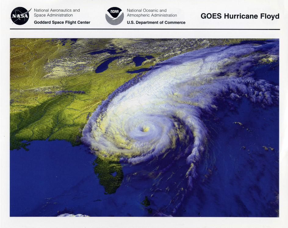
This image of Hurricane Floyd was taken from the National Oceanic and Atmospheric Administration 's (NOAA) GOES-8 geostationary satellite as Hurricane Floyd approached the East Coast of the United States on September 15, 1999 at 4: 15 p.m. EDT. This image was enhanced and rendered at the NASA Goddard Space Flight Center's (GSFC), Laboratory for Atmospheres, Greenbelt, Md.
Hurricanes are products of the interaction between the tropical ocean and the atmosphere. Powered by heat energy from the sea, hurricanes are steered by the easterly trade wi nds and the temperate westerlies as well as by their own ferocious energy. Around their core, winds grow with great velocity, generating violent seas. Moving ashore, they can produce a tremendous storm surge while spawning tornadoes and producing torrential rains and floods. According to the National Hurricane Center, on average, 10 tropical storms (six of which become hurricanes) develop over the Atlantic Ocean, Caribbean Sea, or Gulf of Mexico each year.
Timely warnings have greatly diminished hurricane fatalities in the United States. NOAA's National Hurricane Center and National Weather Service field offices team up with federal and local agencies, rescue and relief organizations, and the news media in the warning and preparedness effort.
The GOES system is a key element of U.S. weather monitoring and forecast operations and is a key component of NOAA's National Weather Service modernization program. Spacecraft and ground-based systems work together to accomplish the GOES mission of providing weather imagery. Together, they provide quantitative sounding data that form a continuous and reliable stream of environmental information for weather forecasting and related services.
The GOES I-M satellites provide weather imagery and atmospheric sounding information for improved weather services, particularly for timely forecasting of life-and propertythreatening severe storms. This series of environmental satellites carries two major instruments: an Imager and a Sounder. These instruments acquire high-resolution visible and infrared data, as well as temperature and moisture profiles of the atmosphere. They continuously transmit these data to ground terminals where the data are processed for rebroadcast to primary weather service offices in the United States and around the world, including the global research community.
In addition to these two primary instruments, GOES-M will carry the new Solar X-ray Imager (SXI). The imager will be used to determine when to issue forecasts and alerts of "space weather" conditions that may interfere with ground and space systems. The SXI will observe the sun for solar flares, solar active regions, coronal holes and coronal mass ejections.
National Oceanic and Atmospheric Administration
U.S. Department of Commerce
Images from the SXI will be used by NOAA and U.S. Air Force forecasters to monitor solar conditions that affect space weather. The SXI will fly on future GOES satellites.
Commercial weather groups, universities, the Department of Defense, NASA, and the global research community also use GOES data products. Other users of these products can be found in air and ground traffic control, ship navigation and agricultural sectors.
NASA and NOAA have worked jointly to perfect, develop and complete the GOES program. NASA's GSFC is responsible for procuring, developing and verification testing of the spacecraft, instruments and ground equipment. Following deployment of the spacecraft from the launch vehicle, GSFC is responsible for the mission operation phase leading to injection of the satellite into geostationary orbit and initial in-orbit satellite checkout and evaluation.
NOAA is responsible for program funding and the in-orbit operation of the system. They also determine the need for
FOR THE CLASSROOM 1. The GOES satellites provide a constant vigil for weather conditions that can cause turmoil in our lives such as severe storms, hurricanes and tornadoes. The satellite operates in a "geosynchronous orbit," remaining over the same area of the Earth all the time. To hover over the same area, the satellites orbit 22,240 miles (35,790 km) above the Earth. To help students understand this type of orbit, do the following activity:
Have students work in pairs. Each group of students will need a flashlight and any kind of sticker. One student will represent Earth and the other the GOES satellite. The Earth students will put the sticker on one of their sleeves. The GOES student will hold the flashlight. The students can be challenged to calculate a scale for the distance the GOES student should stand from the Earth student based on the orbit of the satellite. (It should be reasonable for the room where the activity is taking place.) Challenge the GOES students to keep the beam of the flashlight constantly on the sticker placed on the Earth student as the Earth student rotates on its axis.
What direction should the "Earth" rotate? (counterclockwise) What direction should the "GOES" rotate? (counterclockwise) Why is a geostationary orbit the best orbit for a weather satellite?
2. Hurricanes are large storms that form in warm, moist, tropical air near the equator in summer and fall. Moisture from warm ocean water evaporates rapidly. Cooler air from above moves down and pushes more warm air up. This is called convection; warm, less dense, air rises as cooler, denser, air falls.
GOES Hurricane Floyd
satellite replacement. NOAA and NASA jointly design, develop, install , and integrate the ground system needed to acquire, process and disseminate the data from the sensors on the GOES I-M satellites. NASA's Kennedy Space Center is responsible for the launch services.
Data from the GOES spacecraft are helping NASA scientists design instruments for follow-on missions for NASA's Earth Science Enterprise, a long-term research program designed to study the Earth's land, oceans, air, ice and life as a total system.
For more information, visit the GOES web sites: http://goes2.gsfc.nasa.gov http://www.osd.noaa.gov/sats/goes.htm http://rsd.gsfc.nasa.gov/goes/
Convection may be observed in water
Materials for each group of students: 400 rnL beaker, 112 cup of small paper circles from a hole
punch (colored paper circles are easier to observe), hot plate, 300 rnL of water, goggles. Caution: Wear goggles when using the hot plate and boiling water! Can be demonstrated for younger students.
Have students fill a beaker with 300 rnL of water. Place the hole-punch circles in the water. Place the beaker on the hot plate and bring the water to a boil. Have the students observe the behavior 0{ the hole-punch circles and draw a diagram to show how they move.
To check for understanding, ask the following questions:
l.When the'water boils, what happens to the hole-punch circles? (They move in a circular pattern.)
2.Why does this happen? (As the water is heated, it rises. As it gets further from the heat source, it cools and then sinks. The heat again causes the water to rise, and the cycle continues. This movement of heat in currents is called convection.)
When this transfer of warm air moving up and cold air moving down begins to spiral around a central core a potential hurricane is born!
For more Earth Science images on the World Wide Web: http://pao.gsfc.nasa.gov/gsfc/earthlpictures/earthpic.htrn
LG 2001-5-026-GSFC


