Marlborough
Framingham
Natick
Wayland
Sudbury
Sherborn
Ashland
Southborough
Birch Meadow Brook
Birch Meadow Brook
Course BrookCourse Brook
Sudbury RiverSudbury River
Cold Spring BrookCold Spring Brook
Sudb
ury R
iver
Sudb
ury R
iver
Sudbury RiverSudbury River
Baiting BrookBaiting Brook
Land
ham
Brook
Land
ham
Brook
Cochituate Brook
Cochituate Brook
Angelica BrookAngelica Brook
Beaver D
am Broo
k
Beaver D
am Broo
k
Indian Brook
Indian Brook
Hop BrookHop Brook
EvansEvans
Cowassock Brook
Cowassock Brook
Dunsdell BrookDunsdell Brook
MA82056_2008Hager Pond (5)
MA82097_2008Saxonville Pond (5)
MA82126_2008Lake Cochituate (5)
MA82044_2008Framingham Reservoir #1 (5)
MA82069_2008Learned Pond (3)
MA82048_2008Gleasons Pond (3)
MA82112_2008Waushakum Pond (5)
MA82029_2008Dudley Pond (5)
MA82020_2008Lake Cochituate (5)
MA82125_2008Lake Cochituate (5)
MA82127_2008Lake Cochituate (5)
MA82045_2008Framingham Reservoir #2 (5)
MA82038_2008Fisk Pond (4c)
MA82035_2008Farm Pond (5)
MA82106_2008Sudbury Reservoir (4a) (TMDL)
MA82058_2008Heard Pond (5)
MA82046_2008Framingham Reservoir #3 (4c)
MA82055_2008Grist Mill Pond (5)
HagerHagerPondPond
GristGristMillpondMillpond
Callahan StCallahan StPark PondsPark Ponds
Stearnes ReservoirStearnes ReservoirNO 1NO 1
Farm PondFarm Pond
FossFossReservoir NO 3Reservoir NO 3
LearnedLearnedPondPond
GleasonGleasonPondPond
Fiske PondFiske Pond
Chochituate PondChochituate Pond
Sudbury RiverSudbury River
Lake CochituateLake Cochituate
MillMillPondPond
SudburySudburyRiverRiver
BracketBracketReservoirReservoir
NO 2NO 2
WaushakumWaushakumPondPond
DudleyDudleyPondPond
HeardsHeardsPondPond
SudburySudburyReservoirReservoir
90
30
9
126
126
135
9
30
20
MA82A-06_2008Hop Brook (5)
MA82A-06_2008Hop Brook (5)
MA82A-06_2008Hop Brook (5)
MA82A-15_2008Unnamed Tributary (5)
MA82A-06_2008Hop Brook (5)
MA82A-16_2008Unnamed Tributary (5)
MA82A-06_2008Hop Brook (5)MA82A-17_2008
Unnamed Tributary (5)
MA82A-13_2008Eames Brook (5)
MA82A-15_2008 Unnamed Tributary (5)
MA82A-24_2008Indian Brook (2)
MA82A-22_2008Unnamed Tributary (5)
MA82A-26_2008Sudbury River (5)
MA82A-25_2008Sudbury River (5)
MA82A-03_2008Sudbury River (5)
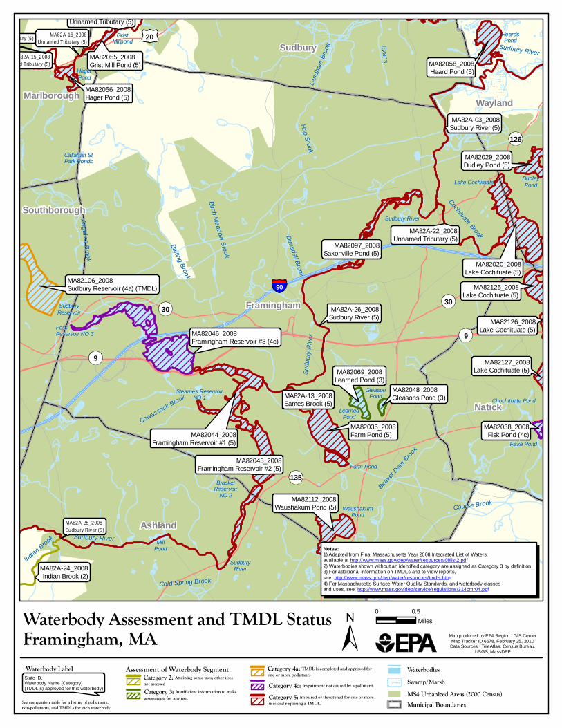
Waterbody Assessment and TMDL Status 0 0.5Miles
Map produced by EPA Region I GIS CenterMap Tracker ID 6678, February 25, 2010
Data Sources: TeleAtlas, Census Bureau,USGS, MassDEP
Framingham, MAWaterbodies
MS4 Urbanized Areas (2000 Census)Municipal Boundaries
Swamp/MarshState ID,Waterbody Name (Category)(TMDL(s) approved for this waterbody)
Waterbody Label Assessment of Waterbody SegmentCategory 2: Attaining some uses; other usesnot assessedCategory 3: Insufficient information to make assessments for any use.See companion table for a listing of pollutants,non-pollutants, and TMDLs for each waterbody
Notes:1) Adapted from Final Massachusetts Year 2008 Integrated List of Waters;available at http://www.mass.gov/dep/water/resources/08list2.pdf2) Waterbodies shown without an identified category are assigned as Category 3 by definition.3) For additional information on TMDLs and to view reports, see: http://www.mass.gov/dep/water/resources/tmdls.htm4) For Massachusetts Surface Water Quality Standards, and waterbody classesand uses, see: http://www.mass.gov/dep/service/regulations/314cmr04.pdf
Category 4a: TMDL is completed and approved for one or more pollutantsCategory 4c: Impairment not caused by a pollutant.Category 5: Impaired or threatened for one or moreuses and requiring a TMDL.


