
FIRE IN OREGON’S FORESTSACHIEVING RESILIENCY IN ALTERED LANDSCAPES
STATE
OF FIRE

THE FIRE DILEMMA “Fire is this wild
process in Oregon. It always has been. But
it often doesn’t mesh well with what humans
want.” – Tom Spies, US Forest Service ecologist
Describing the 2013 summer fire season,
the Oregon Department of Forestry called
it “epic.”
On those lands protected by the state, it
was the costliest ever, and the first time in
over 60 years that more than 100,000 acres
burned.
Oregon’s forests are changing. The
management objectives and priorities
of federal and private landowners are
evolving. Drought has afflicted parts of the
state, and climate trends are making fire
seasons longer and more intense. And in the
wildland-urban interface, more homes have
been built in the path of wildfire.
The ways Oregonians prevent, fight, manage
and, to some degree, live with wildfire
have grown more complicated – and more
expensive.
This report examines the state of fire
suppression, prevention and management,
and describes various efforts to find the
way forward.
ALARM BELLS Fire’s footprint and price tag are trending up
On the cover: A night back-burn on the Government Flats Complex northeast of Mount Hood during 2013’s “epic” fire season.
Photo: J. Pricher
2

FURTHER COMPLICATIONSClimate: It’s too early to be certain of
long-term effects, but climate change may
bring longer, hotter, drier fire seasons that
make firefighting tougher. Asked how much
a changing climate is part of current trends,
David Summer, director for fire, fuels and
aviation management for the Forest Service’s
Northwest region, says: “It’s real. I can’t define
it, but indications are that our fire season is
going to get longer.”
Housing: The Oregon Department of
Forestry estimates that 750,000 homes
exist in areas where they could be affected
by wildfire (2013 data). Compared to other
states, Oregon’s land-use laws have slowed
the conversion of forestland to housing, but
a Headwaters Economics study says that
until the housing crash in 2008, hundreds of
new homes were built each year in Oregon’s
wildland-urban interface. Protecting such
homes when a fire starts nearby can cost tens
of thousands of dollars per home and put
firefighters at risk. Also, more people living in
forests increases risks of human-caused fire.
Following World War II and
through the 1980s, Oregon fire
crews grew skilled at putting
out human-caused and natural
wildfires. Land managers
strived to suppress all wildfires
to protect timber, water,
wildlife habitat and recreation
opportunities. Since the 1990s,
however, and especially on
federal lands, the total number
of acres burned each year has
trended upward. The average
fire size is also growing. The
cost of fighting those fires has
soared.
Acres burned in Oregon annually
Includes public and private forestlands in Oregon. (Sources: Northwest Coordination Center and Oregon Department of Forestry)
0
200,000
400,000
600,000
800,000
1,000,000
19
70
19
7119
72
19
73
19
7419
75
19
76
19
77
19
78
19
79
19
80
19
81
19
82
19
83
19
84
19
85
19
86
19
87
19
88
19
89
19
90
19
91
19
92
19
93
19
94
19
95
19
96
19
97
19
98
19
99
20
00
20
01
20
02
20
03
20
04
20
05
20
06
20
07
20
08
20
09
2010
2011
2012
2013
TREND
3

ECOLOGYThe historic role of forest fire in Oregon
For humans, wildfire can be terrifying,
economically disastrous, even deadly. For
the forest, fire may be a housekeeper, or a
way of starting over. Oregon has different
kinds of forests that have been shaped by
different kinds of fires.
DRY FORESTS
In the dry ponderosa pine forests of central
and eastern Oregon, fire historically
burned through an area every two to 25
years. Flames usually stayed low to the
ground and burned off understory grass,
shrubs and young trees, especially firs.
Mature ponderosa pines tolerate these fires
and usually survive with no more than some
black char on their thick bark. A few young
ponderosas may survive, too. These fires
helped create the open, park-like forests
How fire historically behaved in Oregon forest types
Wet Forests
Southwest Oregon
Dry Forests
FIRE FREQUENCY: EVERY 100 TO 450 YEARS. FIRE SEVERITY: HIGH
FIRE FREQUENCY: EVERY 5 TO 50 YEARS. FIRE SEVERITY: MODERATE/MIXED
FIRE FREQUENCY: EVERY 2 TO 50 YEARS. FIRE SEVERITY: LOW/MIXED
4

pioneers encountered in eastern Oregon,
with widely spaced trees and limited
understory. The fires usually were not
intense, because their frequency kept the
amount of fuel in check.
WET FORESTS
In the temperate Douglas-fir forests on the
west side of the Cascades and in the Coast
Range, it’s a different story. The cool, wet
weather and long growing season create a
dense vegetative cover and a much shorter
fire season. There are fewer lightning
strikes, too, so less opportunity for a fire
to start – at least from a natural cause. Fire
in any given stand is much less frequent,
but because of the large amount of fuel,
potentially much more intense if weather
conditions are ripe. Under such conditions,
these fires historically could be very large,
up to several hundred thousand acres.
“When it does happen, it burns with really
high intensity and great change – positive or
negative, depending on your point of view,”
says US Forest Service ecologist Tom Spies.
It’s often what is called a “stand-replacement
fire,” killing most of the forest, leaving a sea
of snags and scattered living trees or patches
of trees, which reseed the area and allow the
forest to regrow – eventually.
Of course, it regrows on what Spies calls
“forest time.” “It’s not like ‘human time,’” he
says. “Humans can’t relate to an organism
that can take decades to recolonize a site and
live for 800 years, which Douglas-fir can do,
until fire or something else kills it.”
SOUTHWEST OREGON FORESTS
Interior southwest Oregon forests have
the dryness of east-side forests but with
productivity and fuel loadings more like
west-side forests. They are intermediate in
fire behavior but generally lumped with fire-
dependent pine forests of eastern Oregon.
Dry mixed-conifer forests in eastern and
southwestern Oregon typically burned with
mixed severity every 25 to 50 years.
DIFFERENT FORESTS, DIFFERENT FIRE
In the dry forests: (far left) Low-intensity fire
blackens the lower trunks
of ponderosa pines, but the
trees normally survive this
type of fire.
In the wet forests: High-intensity fire climbs
into the canopy, burns
intensely hot and kills most
of the trees, leaving only
scattered patches of live
trees. The aftermath of such
a fire is seen in this historic
image of the Tillamook Burn.
5

Living with fire is a conundrum. On the
one hand, it’s part of the ecosystem. On the
other, it takes lives, destroys property, and
impacts water and wildlife habitat.
THE EAST SIDE
In the dry forests of central and eastern
Oregon, the historic role of fire as thinner,
pruner and housecleaner all but ended in
the 20th century.
“Around 1880 or 1890, it’s like someone
flipped a switch and fire stopped. There was
no more fire,” Spies says.
Increased livestock grazing removed
grasses that carried flames along the
ground. The influence of Native American
populations, which frequently set fires to
enhance wildlife habitat and create open
hunting conditions, declined due to disease
and relocation. Now-outdated practices led
to the harvest of many of the fire-resistant
ponderosa pines.
It’s in eastern Oregon that these changes
have had the most dramatic effect. Small
grand firs and Douglas-firs sprang up
among the ponderosa pines. Without fire to
clear them out, the forests became crowded
with smaller trees of species that are less
adapted to fire than ponderosa pine. This
buildup in the understory has made these
forests more susceptible to high-intensity
“stand-replacement” fire.
“The fact that there’s a big, high-severity
fire on the west side, that shouldn’t
surprise anybody,” Spies says. “Whereas
a big high-severity fire on the east side
is generally viewed as undesirable and
uncharacteristic.”
THE WEST SIDE
Lush forests in the Coast Range and on
the western slope of the Cascades have
always had large amounts of fuel, but fires
here have been kept in check by moisture.
Seventy years of fire suppression has
had less effect here because the intervals
between fires is so long anyway.
But the mosaic of different-aged forests that
fire might create on the west-side landscape
has changed. Lower-elevation private
forestlands managed for timber production
typically vary in age from zero to 50 years
or so.
On federal land, most of the forests are
becoming older, and although there is a
legacy of harvested areas from before 1994,
these days there are fewer open areas that
might come from fire or logging, Spies says.
“If a fire does happen on the west side on
federal land, they try to put it out because
they don’t want it to blow up into a high-
severity fire,” Spies says. There’s too much
at risk: adjacent private timberland and
homes, not to mention the old-growth
habitat that federal managers are now
working to preserve and create. “To some
degree, we’re losing the ecological role of
fire on the west side,” he says.
Humans have changed the face of fire
UNINTENDED CONSEQUENCES
6

Stephen Fitzgerald, a silviculture and fire
specialist with the Oregon State University
College of Forestry, says, “Conditions are
not forcing our hand to think about fire in a
different way in northwest Oregon, because
it’s so infrequent.”
SOUTHWEST OREGON
The story in southwest Oregon is
somewhere in between, mixing elements
of east and west. Melvin Thornton, district
manager for the Douglas Forest Protective
Association, says, “In southwest Oregon,
we have much drier climate than northwest
Oregon, and much heavier fuels than
eastern Oregon. In some ways we have the
worst of the two: dry and heavier fuels.”
The checkerboard of land ownership in
much of this region – a square mile of
federal land alternating with a square mile
of private land – magnifies the differences
in the way those lands are managed.
The Douglas Complex Fire in 2013 brought
those differences into focus (see page 8).
Historically, there were many smaller fires on dry
forests. Before World War II, the biggest severe
fires in Oregon history occurred in the wet forests
on the west side. Today, many large severe fires
occur in the drier forests on the east side and in
southwest Oregon. Atypical forest conditions have
spawned atypical wildfires in many areas.
Many studies examining fire scars on old trees in
eastern and southwestern Oregon prior to Euro-
American settlement reveal abundant natural fires
up until the late 1800s.
WET FORESTS DRY FORESTSUNINTENDED CONSEQUENCES
1868 Coos Bay: 296,000
1853 Yaquina: 482,000
1849 Siletz:
800,000
2002 Biscuit:
500,068
2007 Egley
Complex: 140,359
1848 Nestucca: 290,000
1945 Wilson River/Salmonberry:
180,130
1933 Tillamook: 240,000
1936 Bandon: 143,000
2001 Lakeview Complex: 179,400
1944 Smokey Bear ad campaign debuts
1841 Oregon Territory formed
1941 Keep Oregon Green fire-prevention program launched
1935 USFS institutes “10 a.m. Rule” (Every fire should be suppressed by 10 a.m. the day following its initial report)
1973 USFS begins backing off “10 a.m. Rule”
1992 Drop-off in active management begins on federal lands
1841-1880 Native Americans moved to reservations
1880 Large-scale grazing begins east of Cascades
1906 US Forest Service formed
1910 “Big Blowup” fire in Washington, Idaho and Montana prompts calls for aggressive attacks on wildfire
2000
1980
1960
1940
1920
1900
1880
1860
1840
1820
1800
2011 High
Cascades Complex: 108,154
2012 Barry Point:
93,000
1987 Silver: 97,000
1939 Saddle
Mountain: 190,000
2002 Winter/Toolbox Complex: 120,085
2003 B&B
Complex: 90,769
2014 Douglas Complex: 48,000
7

DOUGLAS COMPLEXA southwest Oregon case
THE FIRESTORM A 200- to 300-foot fire whirl erupts
off Rabbit Mountain during the Douglas Complex Fire.
“We fight fire aggressively,” says Nancy Hirsch, the Oregon
Department of Forestry’s fire division chief. “But when fuel
loads are high, there’s a tremendous amount of heat and fire
behavior that doesn’t allow for direct suppression tactics.”
On the first afternoon of what became
known as the Douglas Complex Fire, Phil
Adams, land and timber manager for
Roseburg Forest Products, stood with a fire
crew on a ridge near Rabbit Mountain.
“We just looked at each other, and we knew
something bad was going to happen,”
Adams remembers. “The wind changed,
and the old-growth stands on the BLM lands
exploded, taking our lands with them. We
saw 200-foot crown fires over the top of 150-
to 200-foot-tall Douglas-fir. At that point,
there was nothing to do. We just backed up.”
The Douglas Complex Fire burned 48,000
acres across what’s known as “the O&C” –
which dates to the 19th century when the
federal government granted land to the
Oregon & California railroad company. The
deal eventually went bad, the government
got the land back, and the result today is
alternating one-square-mile blocks of
federal and private land. It’s often called “the
checkerboard,” because that’s what it looks
like on a map.
While many of the BLM squares are
still managed for timber production,
many others have been designated “late-
successional reserves” since the 1990s. The
goal is to let them develop into old-growth
DOUGLAS COMPLEX FIRE
• Ignition: July 26, 2013; lightning strike
• Acreage burned: 48,000
• Private/public: 23,000 acres private/25,000 acres Bureau of Land Management
• Largest single day: 12,000 acres on July 27
• Firefighting cost: $54 million
• Roseburg Forest Products’ loss: 11,000 acres – 8,000 acres with young trees that will require reforestation; 3,000 acres of older, salvageable trees
Photo: Oregon Department of Forestry
8

habitat for the northern spotted owl and
other species. There is little, if any, timber
harvest on those. Litigation on areas
managed for “timber production” has
reduced active management there, too.
The privately owned squares typically
operate as intensively managed forests,
many owned by Roseburg Forest Products,
which has 80 percent of its timberland
mixed in with the O&C BLM land.
Landowners such as Roseburg worry
about the amount of fuel building on those
reserved BLM lands. While thinning or
other fuels-reduction projects on those
lands are possible, policy priorities, lack of
funds and opposition from environmental
groups make them difficult and in the short
term unlikely.
“This is the story of the O&C right
now,” Adams says. One group wants to
be operating for economic and social
considerations, and one envisions long-
term, broad-landscape habitat concepts.
“How do you reconcile these two things
in a patchwork ownership?”
IN THE WUI:Helping themselves
The Firewise program works locally to reduce the loss of life, property and resources to wildland
fire, by building and maintaining communities in ways that are compatible with their natural
surroundings. Firewise communities in Oregon number about 50.
“There’s a definite shift in focus these days, from treating fuels on individual properties to
mitigation efforts at the community level,” says Keep Oregon Green Executive Director Kristin
Babbs. “Homeowners are increasingly looking for a more collaborative approach to not only
reduce their own risk, but to protect neighboring homes from the threat of wildfire.”
`
Douglas Complex: fire footprint and land ownership
FIRE AREA
PRIVATE LANDS
BLM LANDS
The Douglas Complex Fire
burned in two large patches
in the “O&C,” a checkerboard
of private and federally owned
land in southwestern Oregon.
In the map above, the green
squares are private land, and
the tan squares are public
land managed by the BLM.
The unnatural ownership
pattern makes management
complex and sometimes
counterproductive.
9

BARRY POINT An eastern Oregon case
e11
11e
e11
140 140140
Dog Lake RD
Tun
nel
Hil l
RD
We
st
Sid
e R
D
dR lli
H ydn
A
dR lli
H ydn
A
dR
doo
wnotto
C
DR
ediS ts
eW
StH
wy
140
StHwy 140
AUG. 5, 1600 HRS
MAJOR FS RDS
STATE BOUNDARY
Total acres
Growth acres
AUG. 6, 2012 258 ACRES 258
AUG. 7, 2012 1,587 ACRES 1,329
AUG. 8, 2012 3,212 ACRES 1,625
AUG. 9, 2012 11,813 ACRES 8,601
AUG. 10, 2012 17,277 ACRES 5,464
AUG. 11, 2012 28,401 ACRES 11,124
AUG. 12, 2012 30,824 ACRES 2,423
AUG. 13 2012 45,484 ACRES 14,660
AUG. 14, 2012 74,568 ACRES 29,084
AUG. 15, 2012 83,791 ACRES 9,223
AUG. 16, 2012 92,614 ACRES 8,823
AUG. 17, 2012 92,629 ACRES 15
AUG. 20, 2012 92,977 ACRES 348
In the end, it burned 93,000 acres.
Drought, unusual winds and exceedingly
low humidity, even at night, converged onto
an unnaturally dense dry forest, creating
the Barry Point Fire. It burned hot, with
large patches of stand-replacing crown fire,
historically unusual in a ponderosa forest.
Paul Harlan, vice president of resources
at Collins, the major private landowner in
southern Lake County, heard the initial
report come over the radio on Aug. 5 from a
lookout on Dog Mountain.
Within 30 minutes, the lookout estimated
the fire at seven acres, with wind-carried
embers igniting new fires 300 yards ahead
of the main fire.
The map shows the acreage
burned each day during the fire.
On Aug. 14 alone, 29,000 acres
burned.
Barry Point Fire progression
Photo: Fremont-Winema National Forest
10

THE TRUE COST OF WILDFIREThe price of firefighting is just a fraction of it
PROPERTY LOSS: Standing timber is not an asset that is typically insurable
against fire. Burned timber on both private and public land can result in millions
of dollars in losses for landowners, usually many times the cost of putting the
fire out. It may wipe out decades of investment in planting and nurturing a
forest, including taxes paid and growing time.
WATER: Fire can damage water quality, which is especially important if it burns
in a watershed that is the source of drinking water to a city or town.
ECONOMY: Government spending during the fighting of a fire may give a
temporary boost to some businesses in an affected community, but wildfires
may hurt those who rely on travel, tourism and recreation. River guides, motels,
restaurants and many others all suffer as tourists leave or stay away, sometimes
for years after the fire. Losses can amount to millions of dollars.
WILDLIFE: Fire can create open spaces and dead trees (snags and down logs)
that some animals need, but it also can damage old, complex habitat that land
managers are trying to protect for endangered or threatened fish or wildlife.
SMOKE: Smoke from big fires releases many tons of harmful particulate matter
and greenhouse gases. For example, the 2002 Biscuit Fire in southwest Oregon
released about one-quarter of the total amount of carbon dioxide exhausted in
Oregon that year. Smoke also poses acute risks to public health and exposes
firefighters to long-term health risks.
Photo: Oregon Department of Forestry
The blaze spread to the east and northeast
for nearly a week. Then the wind started
blowing from the north, unusual in August.
The fire turned south, toward California.
“You get that sick feeling in your stomach,”
Harlan says.
The fire exploded overnight, burning about
15,000 acres and crossing the state line.
Within the next few days it consumed more
than 20,000 acres of Collins’ ponderosa-
pine timberland.
Jim Walls, who leads the Lakeview
Stewardship Group, a collaborative that
helps design projects to improve the
overstocked conditions in the Fremont-
Winema National Forest, was shocked.
“It made me realize we’ve got a bigger
problem than I thought,” he says.
BARRY POINT FIRE
• Ignition: Aug. 5, 2012; lightning strike
• Acreage burned: 93,000
• Public/private: 60,000 acres national forest/33,000 acres private
• Largest single day: 29,000 acres on Aug. 14
• Firefighting cost: More than $23 million
• Collins loss: 23,000 acres of mixed-age timber
11
WHAT TO DO?Opportunities and challenges
EAST SIDE: RESTORATION
Will there be more Barry Point Fires in
Oregon’s ponderosa forests?
“You’re going to have fire on the landscape,”
says William Aney, east-side restoration
coordinator for the Forest Service’s
Northwest Region. “The question is, ‘What
kind of fire do you want?’”
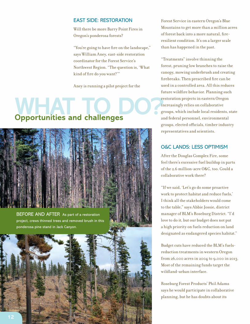
Aney is running a pilot project for the
BEFORE AND AFTER As part of a restoration
project, crews thinned trees and removed brush in this
ponderosa pine stand in Jack Canyon.
Forest Service in eastern Oregon’s Blue
Mountains to get more than a million acres
of forest back into a more natural, fire-
resilient condition. It’s on a larger scale
than has happened in the past.
“Treatments” involve thinning the
forest, pruning low branches to raise the
canopy, mowing underbrush and creating
firebreaks. Then prescribed fire can be
used in a controlled area. All this reduces
future wildfire behavior. Planning such
restoration projects in eastern Oregon
increasingly relies on collaborative
groups, which include local residents, state
and federal personnel, environmental
groups, elected officials, timber industry
representatives and scientists.
O&C LANDS: LESS OPTIMISM
After the Douglas Complex Fire, some
feel there’s excessive fuel buildup in parts
of the 2.6 million-acre O&C, too. Could a
collaborative work there?
“If we said, ‘Let’s go do some proactive
work to protect habitat and reduce fuels,’
I think all the stakeholders would come
to the table,” says Abbie Jossie, district
manager of BLM’s Roseburg District. “I’d
love to do it, but our budget does not put
a high priority on fuels reduction on land
designated as endangered species habitat.”
Budget cuts have reduced the BLM’s fuels-
reduction treatments in western Oregon
from 26,000 acres in 2004 to 9,000 in 2013.
Most of the remaining funds target the
wildland-urban interface.
Roseburg Forest Products’ Phil Adams
says he would participate in collaborative
planning, but he has doubts about its
12

chances in the O&C’s late-successional
reserves. “I’m open to it, but I don’t see the
light at the end of the tunnel right now.”
WEST SIDE: PREVENTION
In the productive forests of western Oregon,
timber values are higher and more people
live near the forest. With more at stake,
prevention and immediate suppression
remain paramount.
The Oregon Department of Forestry serves
as the fire department for 16 million acres
of forestland. Most of that is private land, as
well as state and municipal forests and, by
contract, BLM forests in western Oregon.
The US Forest Service maintains its own
system to suppress fires on national forests.
ODF’s goal is to extinguish 97 percent of
wildfires before they reach 10 acres. That
means strong initial attack, strategic
positioning of crews and aircraft, and the
use of technology such as remote cameras,
which can be monitored from a central
location and are taking the place of human
fire lookouts. About 30 cameras are in place
around Oregon, primarily in southern
Oregon, and more are planned elsewhere.
“The challenge for the west side is, ‘Can we
use active forest management to produce
some of the benefits of fire?’” Spies says. “A
clearcut is not entirely like a fire, but you
can use forest management to imitate some
of the effects of fire.”
LET FIRE DO SOME WORK?
Because the problem of overstocked
national forests in eastern Oregon is so vast
– millions of acres – there’s discussion of
letting fire “do some of the work.”
Fitzgerald raises the idea: If a fire is burning
and can be safely contained, then instead of
spending $3,000 an acre to suppress it, we
can manage the fire under prescription. But
he stresses this isn’t about letting any fire
burn. “There’s a huge checklist you’ve got
to go through” to do it responsibly, he says.
“You’re still going to suppress it in August,
for instance, but maybe burn in October.”
Mike Dykzeul, forest protection director for
the Oregon Forest Industries Council, an
association of large private landowners, has
concerns. He appreciates that the careful
use of prescribed fire on previously treated
forests can improve forest health, but he’s
concerned about the potential transfer of
risk between landowners that comes with
the use of managed fire in the forest, in case
the fire gets away.
PERCENT OF FORESTS IN WATERSHED IN NEED OF RESTORATION
<10%
10% - 25%
26% - 35%
36% - 45%
46% - 100%
The Nature Conservancy and the US Forest Service are jointly analyzing how many acres
are in need of treatment to restore more fire resilient and sustainable forests. The analysis
compares the structure of today’s forested landscapes to the historic range of variation
in forest structure prior to European settlement. This map highlights the percentage of all
forests within a watershed in immediate need of mechanical thinning and/or fire to reduce
tree density and/or canopy cover. Overall, more than 6.6 million acres of fire-adapted
forests in Oregon have been identified as being in need of restoration.
Forest restoration needs
13

AFTER THE FIREDifferent approaches to recovery
After the fire, the question arises: Should the burned area be managed by
salvaging the timber and replanting, or left to recover on its own?
SALVAGE AND REPLANT A few months after the Douglas
Complex Fire, salvage was well underway on private timberland on Rabbit
Mountain. The legacy of Oregon’s historic Tillamook and Oxbow burns
offers a clear blueprint for forest managers such as Roseburg Forest
Products’ Phil Adams. This plan calls for salvaging standing dead trees,
assuming they’re big enough, to recoup some value while removing snags
that could fuel future fires, called “reburns” – and then getting seedlings in
the ground to start growing a new forest.
It all has to happen within a couple years, as burned trees quickly begin to
lose value as they rot and are attacked by fungus and bugs.
A MIDDLE GROUND A salvage project following the 2003 Davis
Lake Fire removed some commercial timber but left many large dead
trees still standing for habitat. A few seedlings were planted, too. OSU
silviculturist Stephen Fitzgerald points to this model as one compromise
approach on federal land. “The forest will develop in a more natural way.
It won’t look like a plantation. It won’t look all black, either. We got some
economic value out of it, we removed some fuel loading and left some
valuable wildlife trees and snags, and we helped jump-start the next
generation of forest. I think this works.” This forest will likely not burn like
a plantation in a future wildfire.
LEAVE IT Following the Douglas Complex Fire, the BLM removed potentially hazardous burned
trees along roads and is selling trees that were cut by crews fighting the fire. Necessary environmental
analysis for economic salvage of timber takes time. Given the emphasis on developing old-growth
habitat in much of the burned land, BLM’s Abbie Jossie acknowledges that a lot of snags will likely
remain on the landscape. But standing dead trees provide fuel for a future “reburn,” a big concern for
Adams, whose company is planning to invest $6 million in new seedlings to replant its land.
To some extent, Jossie agrees: “If we’re going to leave standing fuel, should we be creating some kind
of a buffer between it and the private landowner? Or between it and a green patch of BLM land that’s
still intact and providing good-quality owl habitat? We don’t want that to burn either,” she says. “We
don’t want to burn ours or theirs.”
Much of the BLM forests and plantations that burned were “matrix” lands not reserved for habitat. The
BLM has more latitude to salvage commercially valuable timber on the matrix land.
Photo: Stephen Fitzgerald
14

Building political will and funding prevention
A PLACE FOR POLICY Oregon’s U.S. Sens. Jeff
Merkley and Ron Wyden
tour the Douglas Complex
Fire in 2013, Oregon’s most
challenging fire season
in more than 60 years.
More than 100,000 acres
burned, and firefighting
costs of $122 million set a
record. Timber losses were
estimated at about $370
million.
Photo: Oregon Department of Forestry
PICK UP THE PACEIn January 2013, Gov. John Kitzhaber called
it “mind-boggling.” The summer before,
the federal government had spent more
than a billion dollars fighting fires and less
than a third of that doing preventive work.
“It doesn’t make sense,” he told the Oregon
Board of Forestry.
Oregon’s forests have tremendous ecologic
and economic value. Basically, we have two
kinds of forests, and they require different
approaches to minimize fire.
EASTERN AND SOUTHWESTERN
More than 6.6 million acres of dry forests
in Oregon need restoration to reduce the
risk of large, uncharacteristic fire. Local
collaboration and active management can
restore forest health and fire resiliency, but
success will mean picking up the pace.
The 2013 Legislature allocated $2.88
million to support collaborative groups,
advance restoration and bring resiliency
to forests and rural communities. It’s
important to allow enough time to ensure
success, as results won’t happen overnight.
Prior achievements show collaboration and
restoration work in the long-term.
WESTERN On highly productive western
Oregon forests, wildfires can be severely
destructive, threatening lives and property,
so we must be sure that state and federal
firefighting capacity are up to the task.
The cost of fighting fires nationally has shot
up. The FLAME Act in 2009 was supposed
to address the problem by providing a pool
of money for expensive fire years, so federal
agencies would not have to raid other parts
of their budgets, including prevention and
restoration, to pay for firefighting. But the
program failed to meet expectations.
A new plan, proposed in 2013 by the White
House and bills in Congress, would cap
Forest Service fire suppression budgets and
have the Federal Emergency Management
Administration help fund the big,
expensive fires. This would protect Forest
Service funds earmarked for management.
Since 1985, US Forest Service
spending on fighting wildfires
nationwide has increased
about fourfold. These amounts,
adjusted for inflation, are in
2013 dollars. (Source: National
Interagency Fire Center)
500
1,000
1,500
2,000
19
85
19
86
19
87
19
88
19
89
19
90
19
91
19
92
19
93
19
94
19
95
19
96
19
97
19
98
19
99
20
00
20
01
20
02
20
03
20
04
20
05
20
06
20
07
20
08
20
09
2010
2011
2012
2013
2.0
1.5
1.0
0.5
0
Forest Service firefighting costs nationwide (billions)
15

Download the Oregon Forest Facts & Figures mobile app at Apple’s iTunes store or Google Play
Follow OFRI on Facebook
ABOUT OFRI
The Oregon Forest Resources Institute was
created by the Oregon Legislature in 1991
to advance public understanding of forests,
forest products and forest management
and to encourage sound forestry through
landowner education. A 13-member board
of directors governs OFRI. It is funded by a
dedicated forest products harvest tax.
Paul Barnum, Executive Director
Mike Cloughesy, Director of Forestry
Dave Kvamme, Director of Communications
317 SW Sixth Avenue, Suite 400
Portland, OR 97204-1705
971-673-2944 • OregonForests.org
ACKNOWLEDGMENTS
OFRI is grateful to the many people who gave their time, expertise, insights and
comments during the development of this report: Phil Adams, Roseburg Forest Products;
William Aney, US Forest Service; Kristin Babbs, Keep Oregon Green; Dr. John Bailey,
Oregon State University; Darren Borgias, The Nature Conservancy; Mike Dykzeul,
Oregon Forest Industries Council; Stephen Fitzgerald, OSU; Paul Harlan, Collins; Nancy
Hirsch, Oregon Department of Forestry; Abbie Jossie, Bureau of Land Management;
Dr. Cassandra Moseley, University of Oregon Ecosystem Workforce Program; Greg
Pittman, ODF; Barry Shullanberger, USFS; Dr. Tom Spies, USFS; Mark Stern, The Nature
Conservancy; David Summer, USFS; Melvin Thornton, Douglas Forest Protective
Association.
THE ‘EPIC’ SEASON
On the lines of the Douglas
Complex Fire in summer 2013.


