
ETHEKWINI MUNICIPALITY
INDUSTRIAL LAND STUDY AND
LAND STRATEGY
DEVELOPMENT
INDUSTRIAL LAND STRATEGY
1G-10205
The Planning Initiative Team
June 2014

ETHEKWINI MUNICIPALITY INDUSTRIAL LAND STUDY AND LAND STRATEGY DEVELOPMENT
The Planning Initiative Page i
DOCUMENT CONTROL
TITLE: ETHEKWINI MUNICIPALITY INDUSTRIAL LAND STUDY AND LAND
STRATEGY DEVELOPMENT
INDUSTRIAL LAND STRATEGY 1G-10205
ELECTRONIC FILE: Indus Dev Strat Ph 3 Strat June 2014
REPORT STATUS: Final
REVISION NUMBER: 1
CLIENT: eThekwini Municipality Economic Development and Investment Promotion Unit 12th Floor, Rennies House
41 Margaret Mncadi (Victoria Embankment), Durban, 4001
Tel: 031 311 4247
Fax: 031 332 1720
Email: [email protected]
CONSULTANT: The Planning Initiative P O Box 50660 Musgrave 4062 Tel: +27 31 3129058 Fax: 086 671 1510 Cell: 082 467 1488 Email: [email protected]
DATE: June 2014
REFERENCE NUMBER: 1G-10205
PROJECT TEAM: The Planning Initiative Cathy Ferguson David Briginshaw Joe Kitching Petri Swart
Robynne Hansmann Jeff McCarthy Knight Frank
Martin Fitchet and team
COPIES ISSUED TO: eThekwini Municipality Economic Development and Investment
Promotion Unit
Jeffery J. McCarthy Ph.D.
Development Research and Strategy
ETHEKWINI MUNICIPALITY INDUSTRIAL LAND STUDY AND LAND STRATEGY DEVELOPMENT
The Planning Initiative Page ii
CONTENTS INDUSTRIAL LAND STRATEGY ............................................................................................................................ 1
1 Introduction ............................................................................................................................................. 1
2 Context of the Industrial Land Strategy ..................................................................................................... 3
2.1 Policy Context .................................................................................................................................. 3
2.2 The Reality of Supply and Demand ................................................................................................... 3
2.3 Current Spatial Pattern .................................................................................................................... 4
2.4 Previous Spatial Industrial Strategy 2009 .......................................................................................... 6
2.5 Key Issues - Constraints to Industrial Land Development .................................................................. 6
3 The eThekwini Industrial Land Development Strategy ............................................................................... 7
3.1 Goal and Key Objectives................................................................................................................... 7
3.2 Principles of an Industrial Land Strategy ........................................................................................... 7
3.3 Role of Local Government ................................................................................................................ 8
3.4 Three Primary Strategies .................................................................................................................. 8
INDUSTRIAL LAND IMPLEMENTATION PLAN.................................................................................................... 10
4 Industrial Land Development Strategies and Actions ............................................................................... 10
4.1 STRATEGY 1: Adopt a Decisive, Facilitative Business and Political Culture including Exemplary Urban
Management .............................................................................................................................................. 10
4.1.1 Bold decision making and a Common Municipal position generated by Strategic Leadership ...... 10
4.1.2 Increased Communication between the Municipality and Developers and Marketing the
Municipality as a Port and Industrial City ................................................................................................. 12
4.1.3 Exemplary Urban Management ................................................................................................. 14
4.2 STRATEGY 2: Proactive Infrastructure Delivery ............................................................................... 15
4.2.1 Prioritize Catalyst Projects To Catch Up Delayed Delivery – Strategic Decision Making Team ...... 15
4.2.2 Fast Track Approvals of key/critical Infrastructure Projects for Brownfield and Greenfield priorities
15
4.2.3 Proactive Forward Planning to identify bulk infrastructure projects that will be needed to service
industrial areas ....................................................................................................................................... 15
4.3 STRATEGY 3: Innovation, Research and Development .................................................................... 15
4.3.1 Maintain and Develop the GIS database as an Information and Management tool for the
Municipality and the Private Sector ......................................................................................................... 16
4.3.2 Information Communication Technology (ICT) Capacity ............................................................. 16
4.3.3 Funding and Delivery Mechanisms for Bulk Infrastructure .......................................................... 17
4.3.4 Land Use Schemes and Act 70 of 1970 Applications ................................................................... 17
4.3.5 Support and Promote Green Industrial Development and Environment Research....................... 17
5 Key Spatial Interventions ........................................................................................................................ 19
5.1 Brownfields Intervention ............................................................................................................... 19

ETHEKWINI MUNICIPALITY INDUSTRIAL LAND STUDY AND LAND STRATEGY DEVELOPMENT
The Planning Initiative Page iii
5.1.1 Introduction .............................................................................................................................. 19
5.1.2 Prioritizing Areas for Brownfields Interventions ......................................................................... 20
5.1.3 Decisive Business and Political Culture and Exemplary Urban Management ............................... 26
5.1.4 Lever in additional private investment into the Inner City Industrial Areas ................................. 27
5.1.5 Build Local Partnerships in Urban Management Processes ......................................................... 27
5.1.6 Proactive Infrastructure Delivery ............................................................................................... 28
5.1.7 Innovation, Research and Development ..................................................................................... 28
5.2 Greenfields Interventions .............................................................................................................. 29
5.2.1 Introduction .............................................................................................................................. 29
5.2.2 Prioritizing Areas for Greenfields Intervention ........................................................................... 30
5.2.3 Decisive Business and Political Culture and Exemplary Urban Management ............................... 37
5.2.4 Proactive Infrastructure Delivery ............................................................................................... 37
5.2.5 Innovation, Research and Development ..................................................................................... 37
5.3 The Spatial Application of the Strategies by Planning Region and Industrial Suburbs ....................... 38
6 Institutional Responses and Financial Issues ............................................................................................ 47
6.1 Institutional Responses For Accelerated, Lower-Priced Industrial Land And Delivery ....................... 47
6.1.1 Doing Nothing and Market Interventions ................................................................................... 47
6.1.2 Joint Ventures (JVs)/Public Private Partnerships (PPPs) .............................................................. 48
6.1.3 A Municipal Land Company........................................................................................................ 49
6.1.4 Third Party Facilitation ............................................................................................................... 50
6.2 Institutional Conclusions and Recommendations ........................................................................... 51
6.3 Financial Considerations ................................................................................................................ 51
7 Conclusion and Recommendations.......................................................................................................... 54
8 References.............................................................................................................................................. 55
Appendix A: Draft eThekwini Industrial Development Strategy 2012 UrbanEcon ............................................. 56
Appendix B: Extract from Economic Development Strategy ............................................................................. 59
Appendix C: Existing and Future Identified Industrial Areas ............................................................................. 60
Appendix D: Business Retention and Expansion Programme ........................................................................... 64
Appendix E: Urban Improvement Precincts and Special Rates Areas (SRA)....................................................... 66
Appendix F: Urban Development Zones .......................................................................................................... 67
Appendix G: Institutional Options Discussion .................................................................................................. 69
Appendix H: Application Time Frames............................................................................................................. 73

ETHEKWINI MUNICIPALITY INDUSTRIAL LAND STUDY AND LAND STRATEGY DEVELOPMENT
The Planning Initiative Page iv
Tables
Table 1: Project Phasing and Broad Tasks .......................................................................................................... 2
Table 2: Durban Port TEU Capacity ................................................................................................................. 22
Table 3: Summary of Extent of Industrial development Proposed In the Spatial Development Plans for the
eThekwini Municipality by Planning region ..................................................................................................... 29
Table 4: Industrial Land Strategy by Planning Region and Suburb .................................................................... 38
Table 5: Possible Institutional Responses ........................................................................................................ 47
Table 6: Edmonton Municipal Land Development Enterprise Financial Projections .......................................... 53
Figures Figure 1: Industrial Land Study and Land Development Strategy Project Components ....................................... 1
Figure 2: Existing Zoned and Proposed Industrial Land As Per Approved Spatial Development Plans .................. 5
Figure 3: Proposed Framework for an Industrial Land Development Strategy .................................................... 9
Figure 4: Interaction between Internal and External Processes and various Forums ........................................ 14
Figure 5: Extract from the Industrial Database (2014) GIS Arc Reader Output .................................................. 16
Figure 6: Brownfields areas for Municipal intervention ................................................................................... 21
Figure 7: Port and New Dig-Out Port ............................................................................................................... 22
Figure 8: Clairwood and Jacobs Brownfields Redevelopment Opportunities .................................................... 23
Figure 9: Mobeni Isipingo Brownfields Redevelopment Opportunities............................................................. 24
Figure 10: Inner City Brownfields Redevelopment Opportunities .................................................................... 25
Figure 11: Brownfields Redevelopment Opportunities in Pinetown ................................................................. 25
Figure 12: Existing and Future Industrial Areas with Integration Zones and Dashboard Projects....................... 31
Figure 13: Tongaat Dube Local Area Plan (Northern Urban Development Corridor 2011)................................. 34
Figure 14: Cato Ridge Local Area plan (November 2010 from Outer West Spatial Development Plan) .............. 35
Figure 15: Back of Port Land Use Structure ..................................................................................................... 36
Figure 16: Extent of the Existing and Future Industrial Areas Proposed in the Spatial Development Plans of
eThekwini Municipality................................................................................................................................... 61
Figure 17: Proposed Areas of Industrial Development as Per Spatial Development Plans ................................. 62
Figure 18: 2014 UDZ Area and ward boundary in the eThekwini Inner City Area .............................................. 68

ETHEKWINI MUNICIPALITY INDUSTRIAL LAND STUDY AND LAND STRATEGY DEVELOPMENT
The Planning Initiative Page 1
INDUSTRIAL LAND STRATEGY
1 INTRODUCTION Against a back-drop of development challenges and economic realities, the eThekwini Municipality determined
that it was appropriate to undertake an Industrial Land Study and prepare an Industrial Land Development
Strategy which is up-to-date and considers current market demands and trends. The lack of adequate
information on industrial land was identified as a key barrier to facilitating investment in Durban and unlocking
growth. The local mandate for growth requires that the Municipality develop an Industrial Land Strategy and to
this end, the eThekwini Economic Development and Investment Promotion Unit appointed The Planning
Initiative team in 2013 to prepare an Industrial Land Study and Industrial Land Development Strategy for the
Municipality. The project focusses on both demand and supply-side side information, analysis and proposed
management interventions and strategies for releasing industrial land.
This project consisted of a number of phases as set out in Table 1. This report details the Industrial Land Strategy
as part of Phase 3 which sets out Municipal Land Development Strategy to release or facilitate the release of
appropriate industrial land that meets the demands of the eThekwini market. The elements that have
contributed to the development of the strategy are illustrated in the diagram that follows:
FIGURE 1: INDUSTRIAL LAND STUDY AND LAND DEVELOPMENT STRATEGY PROJECT COMPONENTS
The strategy has been developed through engagement with the Municipality, project Steering Committee
meetings and engagement with the Private Sector via interviews and two wider stakeholder forums held at the
Moses Mabhida Stadium on 14 November 2013 and 14 March 2014.
The project has also delivered a comprehensive GIS database with mechanisms for updating data so that the
Economic Development and Investment Promotion Unit, as well as other Municipal Departments may use this
as a tool to reflect on changes over time, and to provide information to the public. The database includes
information on:
INDUSTRIAL LAND STUDY & LAND STRATEGY DEVELOPMENT
Demand
Private Sector - when, where, what
Data base
what, where, when, on-
going monitoring
Institutional
Context and Models
Policy
Review including
Strategic and Spatial Plans
Opportunities & Constraints
Environ issues, servicing costs,
planning controls etc.
Supply
where, when, costs,
assessing options

ETHEKWINI MUNICIPALITY INDUSTRIAL LAND STUDY AND LAND STRATEGY DEVELOPMENT
The Planning Initiative Page 2
Existing zoned industrial land
Vacant zoned industrial land
Footprint of industrial building digitised from aerial photography for 2002, 2007 and 2012
All land identified in the Municipal package of plans for industrial development or business parks that
would include industrial development
D’MOSS and rivers
Bulk services
Road and rail network
Property size and municipal valuation
Using this database, as well as desk top research, the study has produced the following reports:
Phase 1: Policy and Institutional Review Volume 1, September 2013
Phase 1: Policy and Institutional Review Volume 2, September 2013 (Appendix to Volume 1 which
provides a summary of relevant policy documents and research)
Phase2: Demand and Supply Side Research Results, March 2014
Phase 2: Land Study Analysis, March 2014 (analysis based on the research results)
Phase 2: Task 6 Industrial Case Study Review, March 2014
The contents of these documents form the basis of the strategy detailed in the sections that follow and should
be read in conjunction with this report.
TABLE 1: PROJECT PHASING AND BROAD TASKS
Phase Task Reports
1. Inception Information Collection Inception Report, August 2013 and addendum, April 2014
2. Review Policy Review
Institutional Model Review
Industrial Demand Assessment
Industrial Supply Assessment
Review of Supply and Demand
Implement studies of alternative areas or methods
Phase 1: Policy and Institutional Review Volume 1, September 2013
Phase 1: Policy and Institutional Review Volume 2, September 2013
Phase2: Demand and Supply Side Research Results, March 2014
Phase 2: Land Study Analysis, March 2014
Phase 2: Task 6 Case Study Review, March 2014
3. Strategy Development
Framework Development
Strategy Development
Institutional Models
Implementation Plans
Conceptual Framework, March 2014
Industrial Land Strategy, implementation plans and institutional models
Monitoring and Evaluation Framework
4. Closeout Closeout Report Closeout report This report is broken up into two main sections as summarised below:
THE INDUSTRIAL LAND STRATEGY
Section 2 which examines the factual and policy context background for the Strategy
Section 3 which sets out the land strategy itself
THE INDUSTRIAL LAND IMPLEMENTATION PLAN
Section 4 which details the actions to implement the strategies
Section 5 which details the spatial implementation priorities in Brownfield and Greenfield areas
Section 6 which explores some institutional responses and financing issues for the strategy

ETHEKWINI MUNICIPALITY INDUSTRIAL LAND STUDY AND LAND STRATEGY DEVELOPMENT
The Planning Initiative Page 3
2 CONTEXT OF THE INDUSTRIAL LAND STRATEGY
2.1 POLICY CONTEXT The research undertaken to date indicates that there is a highly developed policy and strategy environment that
is intended to guide and direct industrial development. In terms of the policy and strategies, job creation and
investment promotion are key priorities at all levels of government.
The 2014 budget speech by Minister Pravin Gordhan reiterated Governments commitment to the National
Development Plan to create jobs and eradicate poverty through economic growth. In his speech the Minister
emphasised
Accelerated public Infrastructure investment including increased grants to local government for water,
sanitation, energy and environmental functions;
The preparation of new spatial plans for cities and the implementation of the Integrated City
Development Grant which is key to unlocking development by strengthening long term city planning
and encouraging private sector investment;
Support for Special Economic Zones and Manufacturing Incentives through the Industrial Policy Action
Plan; and
The National Infrastructure plan through the Strategic Integrated Projects
SIP 2: Durban-Free State-Gauteng Logistics and Industrial Corridor
SIP 7: Integrated Urban Space and Public Transport Programme
He noted that “Government will continue to provide an enabling environment for businesses to grow and
create employment” by removing constraints and implementing regulatory improvements.
Within the eThekwini context, the Economic Development Strategy follows the national and provincial lead in
emphasising economic growth for enhancing job creation, poverty alleviation and rates generation.
Spatially the Integrated Development Plan and Spatial Development Framework (including its associated
package of plans) emphasises the need for integrated city growth and densification to maximise the use of
services and minimise travel times. This is being further developed through the National Government
requirement for new city spatial plans and the Integrated City Grant Funding requirements for the preparation
of a Built Environment Performance Plan which includes the identification of Integration Zones within the
Municipality where funding for economic growth will be directed.
Within this context Durban is facing increased competition from large scale infrastructure investments in other
African Port Cities as well as growth of other African countries (Kenya for example) and the challenge is to retain
the role of Durban as a sea and air port gateway to Africa with the requisite logistics infrastructure, and grow
job creation opportunities in Durban on the back of this investment.
2.2 THE REALITY OF SUPPLY AND DEMAND The research highlights that there is a perceived shortage of land for industrial development within the
eThekwini Municipality and that there are long lead times before development commences.
However, the database developed indicates that:
There is vacant zoned industrial land within the Municipality however, it largely consists of single sites
dispersed amongst the existing industrial areas and, other than in the Outer West (where there is still
some large pieces), it can assumed that this is not satisfying market demand (poor location, lack of
access, affected by D’MOSS, etc.)

ETHEKWINI MUNICIPALITY INDUSTRIAL LAND STUDY AND LAND STRATEGY DEVELOPMENT
The Planning Initiative Page 4
There are some 1,400 ha’s of land identified for future industrial use (3,500 Gross of which it is assumed
40% is developable) and some 200 ha within future business park development (total 2500 of which
40% may be developable and 20% may be used for industry) that needs to be zoned and serviced to
address the demand.
Demand appears to be in the region of 30 – 45 ha’s per annum, although latent demand may be in excess of this
if land was readily available. This is demonstrated through the rapid sale of Cornubia as an example.
The nature of the demand is more difficult to determine. Sectors that are currently growing are warehousing
and logistics, whilst overall manufacturing rate of growth has been declining. However, the latest Rode report
notes that with respect to
“industrial rentals, the growth in Durban has been heating up, so much so that in recent quarters this city
has been showing the strongest growth amongst the major industrial regions. During the fourth quarter
of 2013, prime industrial rentals in Durban were up by an impressive yearly rate of 9%. This can be
compared with rentals on the East Rand, which showed growth of only 5%. In the Central Witwatersrand
and the Cape Peninsula, rental growth of 2% was recorded, while in Port Elizabeth there was no growth.
For now, conditions in the manufacturing sector remain “challenging”. This naturally places a lid on the
demand for industrial space and might keep rentals growing at moderate rates. Rand weakness has the
potential of making S.A. goods internationally more competitive – but only for the time being, until
inflation catches up.”
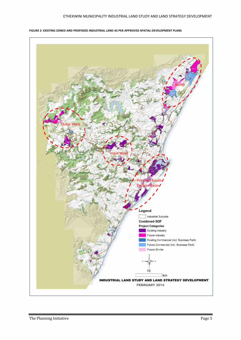
2.3 CURRENT SPATIAL PATTERN The current spatial patterns and plans within the municipality reflect the following:
Port and South Durban Basin – historically this was the first industrial area to be developed. Much
attention is now being given to the area as a result of the need to expand the port and improve access
Inner West – this was the second clustering to be developed. It is historically an important industrial
hub and has consolidated over time.
Outer West – this area has gained attention recently being on the eThekwini-Gauteng corridor. Recent
developments show an increased demand for sites in the area which appears to be growing.
North – the northern area has always had some industrial development however it has been relatively
small in the overall picture. It has now been identified for extensive growth with the New Airport and
Dube TradePort including a much bigger cargo terminal than previously available in eThekwini.
ETHEKWINI MUNICIPALITY INDUSTRIAL LAND STUDY AND LAND STRATEGY DEVELOPMENT
The Planning Initiative Page 5
FIGURE 2: EXISTING ZONED AND PROPOSED INDUSTRIAL LAND AS PER APPROVED SPATIAL DEVELOPMENT PLANS
Port and South Durban Basin
Outer West
Inner West
North

ETHEKWINI MUNICIPALITY INDUSTRIAL LAND STUDY AND LAND STRATEGY DEVELOPMENT
The Planning Initiative Page 6
2.4 PREVIOUS SPATIAL INDUSTRIAL STRATEGY 2009 This strategy was prepared for the Development Planning and Management Unit. The supply analysis focused
on zoned industrial land and planned areas at the time. The analysis of demand was largely sector based. The
strategy was based on three scenarios which hinged around whether the dig out port would happen or not. This
decision has now been made. The EIA is now in progress and the questions are now focused on what form it will
take and when.
The three key strategies arising out of the scenarios were:
1. Unlock existing zoned areas – Hammarsdale and Mpumalanga
2. Reorganize key industrial sites – Back of Port
3. Unlock new opportunity areas – DTP and Cornubia
The purpose of the strategy outlined in this report is to build on the 2009 study and move this strategy forward
to a new level.
2.5 KEY ISSUES - CONSTRAINTS TO INDUSTRIAL LAND DEVELOPMENT The following Key Constraints were identified in the stakeholder engagement process held on 14 November
2013:
Red tape/ regulations/ delays/ pro-active planning/ approach – planning too reactive/ need bold
decisions plus EIAs/ Act 70 of 1970
Bulk infrastructure costs / limited municipal finance / developers contributions / Lack of para-statals
and infrastructure costs
Relationship between developers and municipalities
Lack of co-ordination between departments
Land price – too high / in the hands of a few / needs reducing
Rates and financial incentives
Investor confidence and global economic forces/ macro-economic conditions
Project management and marketing
The team have distilled these into two main issues
1. Greenfields: “Time to Market” - The time of delivery of land to the market. The business cycle from
when a Board of Directors decides to invest in a new project or an upgrade, to when they want to go
live on the investment appears to be in the region of two years. The land cycle, including identification
of land, planning processes and approvals, and provision of bulk infrastructure on the other hand
appears to be in the region of 8 to 10 years (Appendix H). The gap is not tolerable for the market and
needs to be reduced.
2. Brownfields: “Policy of the Small“- Urban management, Crime and grime, Investor aftercare,
Repackaging of areas and overall maintenance needs to be addressed.
ETHEKWINI MUNICIPALITY INDUSTRIAL LAND STUDY AND LAND STRATEGY DEVELOPMENT
The Planning Initiative Page 7
3 THE ETHEKWINI INDUSTRIAL LAND DEVELOPMENT STRATEGY A strategy sets out to achieve a particular outcome / goal or objectives. To be useful the strategy should be
focused on ensuring that a few specific issues are addressed that will shift the way investment in industrial land
is happening, rather than aiming to be comprehensive and address all “ills”. Based on the issues raised during
engagement and the research results, one primary goal and two key objectives for the Industrial strategy have
been developed.
A set of principles for the land development strategy to follow have been developed and building on these, three
primary strategies have been identified as set out below.
3.1 GOAL AND KEY OBJECTIVES The proposed goal of the strategy is as follows:
The eThekwini Municipality will be a proactive facilitator of industrial land development, in order to build
confidence in the market to invest in Durban and contribute towards economic growth and job creation.
The proposed key objectives of the land development strategy are to
manage existing industrial land in order to retain and grow existing investment, and to
facilitate the delivery of an adequate “ready for market” land bank
Land that is “ready for market” would imply that the land is
Zoned for industrial use and bulk services are available; and
Ready for developers to platform and provide the internal road network and infrastructure required.
3.2 PRINCIPLES OF AN INDUSTRIAL LAND STRATEGY The principles upon which the land development strategy should be based were developed through a workshop
with the Project Steering Committee members and were derived as follows:
An industrial land development strategy should be
Driven in the first instance by an interest in the expanded employment opportunities that can be made
available through industrial and warehousing land development and subsequent use.
Long term in orientation i.e. the provision of land for Industrial Growth is obviously a key component
of this picture and is addressed in this strategy. The identification, servicing, obtaining development
rights and release of industrial land is a lengthy process thus a land strategy needs to have a long term
horizon of 20 to 30 years.
Robust, complex and diverse to take into account the dynamics of the industrial market. Given long
lead in times for land release, land that will address the demands of a range of sectors should be the
focus of the strategy – by the time it comes onto the market, growth patterns may well have changed.
Proactive in intent, acknowledging the role of the private sector and government sector investments
as central to economic growth.
Innovative in approach and proposals.
Based on Institutional integration – between different levels of government and different departments
within the Municipality.
Focused on Integrating industrial land use with other land uses to reduce travel times where possible
i.e. efficient and more sustainable city development.
Acknowledging the increase in national and global city integration.

ETHEKWINI MUNICIPALITY INDUSTRIAL LAND STUDY AND LAND STRATEGY DEVELOPMENT
The Planning Initiative Page 8
Focused on clustering industrial activities to achieve economies of scale and create efficient backward
and forward linkages.
Economically, environmentally and socially sustainable acknowledging that trade-offs and mitigation is
part of this process.
Based on a systems approach that acknowledges the larger picture of the city’s development and the
unpredictable, interactive and interdependent nature of industrial development within the city system.
Aimed at minimising the time to market i.e. the time taken to release land for development.
Aimed at improving the efficiency of municipal processes.
Aimed at building on existing initiatives where possible.
3.3 ROLE OF LOCAL GOVERNMENT Currently a key role of the municipality relates to being the regulator of land use and provision of bulk services
within the Municipality. Historically, the Municipality also fulfilled a role as developer of industrial land and
partner with the private sector in development. The municipality has played a developer role in a variety of
partnerships, related to the development of South Durban Basin, Kingsmead Office Park, Springfield, Pinetown
and Riverhorse Valley, with differential institutional models. The Municipality is also a significant general land
owner in eThekwini Municipality and in addition to roads, open space and related municipal land holdings, they
also own industrial land.
The developmental mandate of government suggests that the role needs to be expanded to that of development
facilitator, as well as regulator and bulk service provider. The success of Public Private Parterships in the past
suggest this development strategy should not be completely discounted, although the option may be limited in
scope under the new Public Finance Management Act. This should be picked up in future under research and
development and is discussed in more detail in Section 12.
3.4 THREE PRIMARY STRATEGIES Based on the analysis of existing supply and demand and the issues currently constraining industrial land
development, the project has focused on the key areas that need to be addressed to move the Municipal role
in industrial land facilitation from “business as usual” to a new approach that will result in significant change and
impact on industrial land development.
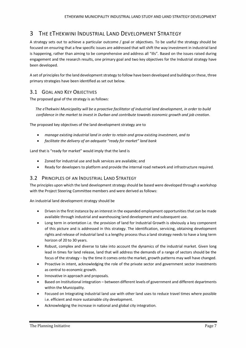
Three primary areas of Intervention or Strategies have been identified around which the facilitation of Industrial
Land Development should be arranged (Figure 3):
1. Decisive Business and Political Culture including exemplary Urban Management Practices
2. Proactive Infrastructure Delivery
3. Innovation, Research and Development

ETHEKWINI MUNICIPALITY INDUSTRIAL LAND STUDY AND LAND STRATEGY DEVELOPMENT
The Planning Initiative Page 9
FIGURE 3: PROPOSED FRAMEWORK FOR AN INDUSTRIAL LAND DEVELOPMENT STRATEGY
Decisive, Facilitative
Business and Political Culture and exemplary
Urban Management
• Bold decision making and a Common Municipal position generated by strategic leadership
• Increased communication between the municipality and developers
• Exemplary Urban Management
Proactive Infrastructure
Delivery
• Prioritize catalyst projects to catch up delayed delivery - dashboard and deal team
• Fast track approvals
• Proactive forward planning
Innovation, Research and Development
• Maintain and Develop the GIS database as an information and management tool
• ICT capacity
• Funding and delivery mechanisms
• Land Use Schemes
• Support and Promote Green Environment Research
Facilitate investment in Industrial Land
Manage Existing/Brownfields
Greenfields ready for market land bank
ETHEKWINI MUNICIPALITY INDUSTRIAL LAND STUDY AND LAND STRATEGY DEVELOPMENT
The Planning Initiative Page 10
INDUSTRIAL LAND IMPLEMENTATION PLAN
4 INDUSTRIAL LAND DEVELOPMENT STRATEGIES AND ACTIONS Three primary strategies have been identified to activate a new approach to industrial land development in
eThekwini:
1. Decisive Business and Political Culture including exemplary Urban Management Practices
2. Proactive Infrastructure Delivery
3. Innovation, Research and Development
This section outlines the objectives of each strategy and the actions required to implement them. Section 5 then
explores how the strategy should be actioned from a spatial perspective, whilst Section 6 explores institutional
and financial issues further.
It is suggested that the actions recommended be taken forward to the Municipal restructuring process and the
Best Practice Commission investigations and findings, and built into these processes.
4.1 STRATEGY 1: ADOPT A DECISIVE, FACILITATIVE BUSINESS AND POLITICAL CULTURE
INCLUDING EXEMPLARY URBAN MANAGEMENT Increased certainty in the business and political culture was identified in the internal and external engagement
processes as key elements that can assist the facilitation role of eThekwini Municipality to redevelop industrial
land, to better manage existing industrial land and facilitate the release of new industrial land. The objective of
this strategy is therefore to provide clear strategic direction, create certainty in the business and political
environment, and improve urban management in order to build confidence in the market to invest in Durban
and contribute towards economic growth and job creation.
4.1.1 BOLD DECISION MAKING AND A COMMON MUNICIPAL POSITION GENERATED BY STRATEGIC
LEADERSHIP
1. Establish/reinforce a Strategic Decision Making team at DCM level to guide policy, planning and
project decisions. This could form a mandate of the existing DCMs forum.
The purpose of this team will be to provide clear strategic direction and decisions to
be followed by all departments
Promote an attitude of “how can we approve this application/development
responsibly” rather than “what is wrong with this application from the outset.”
Chaired by the Municipal Manager
Build on the existing deal team concept
Attended by DCMs and Heads of Departments
All departmental Heads to be responsible for taking plans and strategic projects to
this meeting to obtain decisive guidance
Mechanism for feeding decisions down to the municipal teams to be put in place to
guide departmental decisions
Departments should also feed information up to this team to ensure that strategic
decisions are made on an informed basis and within the constraints of the
Municipality and legislative requirements
Decisions made by this team do not take away the mandates of various departments
and obviously cannot override statutory requirements, however clear strategic

ETHEKWINI MUNICIPALITY INDUSTRIAL LAND STUDY AND LAND STRATEGY DEVELOPMENT
The Planning Initiative Page 11
guidance will assist in prioritizing city decision making and this team will provide a
forum where key projects may be discussed, processes agreed and resolutions made.
2. Establish an Inter-Departmental Approval Team for development applications - planning,
environment, transport and infrastructure as key departments
The purpose of the team will be to provide an interdepartmental forum to discuss
and make decisions to assist in overcoming the silo effect of large departments within
the complex city structure
Chaired by the Planning and Development Management Department.
All applications for industrial development (rezoning, scheme amendments, special
consent applications, EIAs) to be brought to this forum for discussion so that the views
of all departments are heard and discussed in the context of the SDF, SDPs and any
other policy documents. This is required to promote integrated decision making and
avoid the current situation of silo decision making that often results in conflicts in
decisions between departments.
Planning and Development Management Department must play a mediation and
decision making role within the context of strategic direction from the DCM level and
the SDF and not just coordinate departmental comments.
Strategic guidance to be taken from the Strategic Decision Making team.
3. Improve Systems, Facilitate and Fast Track Approvals
The purpose of this action is to Improve time frames of approval process for Planning
Applications
The one-stop-shop/Information centre (team) (recommended in 4.1.2 (2) below) to
be capacitated with
Clear diagrams of who has to be consulted on an application
List of contact names and numbers – they need to be tasked with updating
this every 6 months to keep it current
Detail the application and circulation process clearly.
Economic Development Investment Promotion Unit to become part of the
circulation process.
Make information of land and existing development rights accessible on the
Website.
Once an application is submitted Planning Officers tasked with an application must
circulate and follow up with Departments and report back to the applicant every two
weeks – a written record of this communication to be kept.
If the Planning department are of the view that a development over an amount to be
agreed should be refused this must be referred to the DCMs forum before a
recommendation is made to Council.
Applications for Industrial Development should include the socioeconomic benefit of
the development as well as an estimate of the costs of infrastructure required.
4. Appoint Project Facilitators (internal personnel or consultants appointed eThekwini) to assist
developers through the approval processes and unlock blockages on strategic projects.

ETHEKWINI MUNICIPALITY INDUSTRIAL LAND STUDY AND LAND STRATEGY DEVELOPMENT
The Planning Initiative Page 12
To be appointed by DCMs forum once an in principle decision has been made to
explore the merits of a project further.
Ideally these facilitators should report into the One-stop-shop facility to concentrate
the knowledge base and co-ordinate different projects and priorities. If this is not
feasible the project facilitators must meet together on a regular basis under the
auspices of this one-stop-facility to share information, ideas and prioritise.
Project facilitators to arrange and administer regular project meetings/developer
forums with the private sector developer to discuss and resolve project specific
issues.
Project Facilitators to track and monitor EIA, Planning and Infrastructure applications
for major projects as part of a data base. This information should then be used to
understand where delays are occurring and where the Municipality may or should
assist, if at all. (This could possibly feed into updating the Durban Investment
Dashboard).
Track and monitor the Department of Agriculture approval in terms of the Subdivision
of Agricultural Land Act No 70 of 1970 within three month time period.
5. Elevate the role of the Spatial Development Framework (SDF) as reviewed in the context of the
Built Environment Performance Plan and Integrated City Development Initiative and associated
package of plans to an Integration tool and create a common spatial vision and policy for the City
in order to achieve integration between departments
Every DCM should have a copy of the SDF and SDPs in his/her office, and every
planning, infrastructure and economic department should have a copy of the SDF in
its boardroom.
Publish all approved spatial plans on the web-site.
Present spatial plans at a regular Developers forum.
Implement a regular revision and updating process.
4.1.2 INCREASED COMMUNICATION BETWEEN THE MUNICIPALITY AND DEVELOPERS AND MARKETING
THE MUNICIPALITY AS A PORT AND INDUSTRIAL CITY
1. eThekwini Strategic Developers Forum
With KZN Growth Coalition, SAPOA, Chamber of Commerce and Industry, private developers
active with the development in the Municipality and representatives of the Industrial Clusters
with representatives of DCMs (Economic Development and Planning; Human Settlements and
Infrastructure; Finance) and the Chair or Deputy Chair of ECOD
To meet four times per year to resolve strategic issues, and present and discuss future planning
and opportunities and any relevant research and innovation work undertaken.
Could be administered by Investment Promotion Agency as the first link with developers.
Various departments such as Framework Planning, LUMS and Infrastructure Departments to
attend to give presentations and answer questions.
Build on the existing initiative that Development Management and Planning have with the
Chamber of Commerce.
ETHEKWINI MUNICIPALITY INDUSTRIAL LAND STUDY AND LAND STRATEGY DEVELOPMENT
The Planning Initiative Page 13
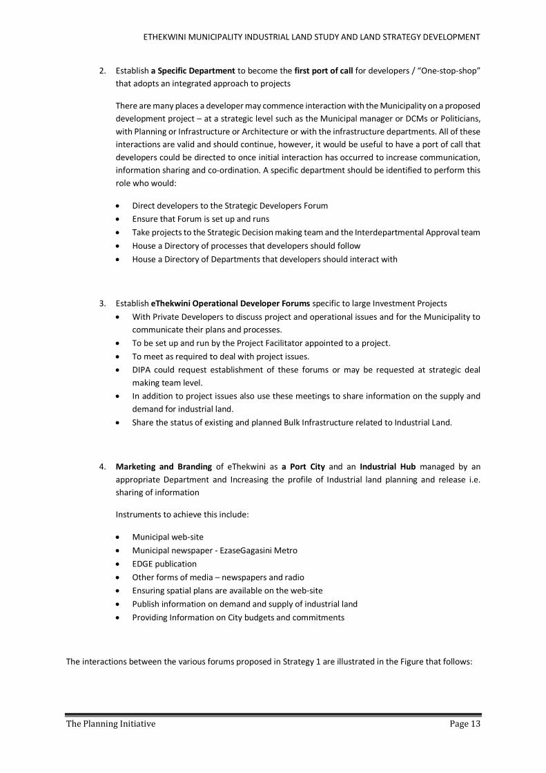
2. Establish a Specific Department to become the first port of call for developers / “One-stop-shop”
that adopts an integrated approach to projects
There are many places a developer may commence interaction with the Municipality on a proposed
development project – at a strategic level such as the Municipal manager or DCMs or Politicians,
with Planning or Infrastructure or Architecture or with the infrastructure departments. All of these
interactions are valid and should continue, however, it would be useful to have a port of call that
developers could be directed to once initial interaction has occurred to increase communication,
information sharing and co-ordination. A specific department should be identified to perform this
role who would:
Direct developers to the Strategic Developers Forum
Ensure that Forum is set up and runs
Take projects to the Strategic Decision making team and the Interdepartmental Approval team
House a Directory of processes that developers should follow
House a Directory of Departments that developers should interact with
3. Establish eThekwini Operational Developer Forums specific to large Investment Projects
With Private Developers to discuss project and operational issues and for the Municipality to
communicate their plans and processes.
To be set up and run by the Project Facilitator appointed to a project.
To meet as required to deal with project issues.
DIPA could request establishment of these forums or may be requested at strategic deal
making team level.
In addition to project issues also use these meetings to share information on the supply and
demand for industrial land.
Share the status of existing and planned Bulk Infrastructure related to Industrial Land.
4. Marketing and Branding of eThekwini as a Port City and an Industrial Hub managed by an
appropriate Department and Increasing the profile of Industrial land planning and release i.e.
sharing of information
Instruments to achieve this include:
Municipal web-site
Municipal newspaper - EzaseGagasini Metro
EDGE publication
Other forms of media – newspapers and radio
Ensuring spatial plans are available on the web-site
Publish information on demand and supply of industrial land
Providing Information on City budgets and commitments
The interactions between the various forums proposed in Strategy 1 are illustrated in the Figure that follows:

ETHEKWINI MUNICIPALITY INDUSTRIAL LAND STUDY AND LAND STRATEGY DEVELOPMENT
The Planning Initiative Page 14
FIGURE 4: INTERACTION BETWEEN INTERNAL AND EXTERNAL PROCESSES AND VARIOUS FORUMS
4.1.3 EXEMPLARY URBAN MANAGEMENT Ongoing investor aftercare is as important as land release and development. New industrial areas are typically
managed through Management Associations set up to ensure a high standard of development and seem to be
well accepted by the market. However the Municipality must continue to play their role of service provision and
maintenance in these areas.
Urban decay and aging infrastructure in existing industrial areas are more difficult to address but imperative for
retaining investment and attracting new investment. Various mechanisms have been explored over time
including the Business Retention and Expansion programme (Appendix D), Urban Improvement Precincts and
Special rates areas (Appendix E). These are discussed more fully under the Brownfields implementation plan
however at a strategic level the following are proposed:
1. Greenfields areas should be encouraged to establish management associations
2. Consider the role of area based management and industrial estate managers further
3. In areas that have been identified for brownfields redevelopment, build on the Business Retention
and Expansion strategy – specifically to set up urban improvement precincts where possible or
appoint industrial estate managers to develop the programme for each area
4. Radically improve the system of reporting faults and response to this. Possibilities include an area
based system (e.g. South Industrial Basin) or through Industrial Estate Managers located within the
local area and easily contactable through well-known channels.
External Interactions
Strategic Developers Forum
Operational Developers Forum
Developers
Internal Interactions
Strategic Deal Team
Inter-departmental Approval team
Project Facilitators
Information Decisions
Information Decisions
ETHEKWINI MUNICIPALITY INDUSTRIAL LAND STUDY AND LAND STRATEGY DEVELOPMENT
The Planning Initiative Page 15
4.2 STRATEGY 2: PROACTIVE INFRASTRUCTURE DELIVERY A key finding of this study was that the major cause of delay in industrial land release is often lack of
infrastructure delivery either due to approval delays, lack of funding or lack of forward planning. A primary
objective of the land development strategy is therefore proactive delivery of infrastructure to firstly manage
existing industrial land in order to retain and grow existing investment, and secondly to facilitate the delivery of
an adequate “ready for market” land bank.
4.2.1 PRIORITIZE CATALYST PROJECTS TO CATCH UP DELAYED DELIVERY – STRATEGIC DECISION
MAKING TEAM 1. The priorities identified in the Greenfields spatial strategy in section 10 should become the focus
on the Strategic Decision Making team – using the Dashboard information and DCM/Deal making
team
2. DIPA or an appropriate department should be empowered to drive the projects.
3. Through the assigned Department, Project facilitators should be appointed and empowered to
facilitate approvals and work across departments to fast track delivery.
4. Approvals must be fast tracked through the interdepartmental approval team.
5. Contentious issues or decisions should immediately be taken back to the Strategic Decision Making
team for resolution within the regulatory framework.
6. Budgets must be realigned through the Strategic Decision Making team to address the priorities.
4.2.2 FAST TRACK APPROVALS OF KEY/CRITICAL INFRASTRUCTURE PROJECTS FOR BROWNFIELD AND
GREENFIELD PRIORITIES 1. Promote clarity on zoning by providing existing zoning and planned new area information on the
Municipal GIS website.
2. Make the infrastructure delivery process explicit to inform investment decisions and choices.
3. Establish the Interdepartmental Approval forum to drive decision making.
4. Use DIPA and the project facilitators to drive project processes.
4.2.3 PROACTIVE FORWARD PLANNING TO IDENTIFY BULK INFRASTRUCTURE PROJECTS THAT WILL BE
NEEDED TO SERVICE INDUSTRIAL AREAS 1. Prioritise Greenfields and Brownfields developments so that delivery can be directed to the
appropriate areas.
2. Senior management decisions need to feed through the organization using the structures
suggested in strategy 1.
3. Place all approved SDFs and SDPs on the Municipal web-site.
4.3 STRATEGY 3: INNOVATION, RESEARCH AND DEVELOPMENT The primary objective with respect to this strategy is for the Municipality to become a learning, growing and
smart city though reflection on existing practice and innovation through research and development that will
provide a step-change in current industrial land development practices and facilitation of the industrial land
development process.
Research projects should be directed through and appropriate research unit such as the EDIPU Research
Division, MILE, Office of the City Manager etc. The key outcome, however, should be to ensure that the research
is fed into practice and is not research for research sake.

ETHEKWINI MUNICIPALITY INDUSTRIAL LAND STUDY AND LAND STRATEGY DEVELOPMENT
The Planning Initiative Page 16
4.3.1 MAINTAIN AND DEVELOP THE GIS DATABASE AS AN INFORMATION AND MANAGEMENT TOOL
FOR THE MUNICIPALITY AND THE PRIVATE SECTOR Investment risk can be reduced by the certainty on the timing and location of public investment
decisions. The EThekwini Municipality Industrial Land Study and Land Strategy Development (2014)
has produced a database of key GIS based information on industrial areas, municipal plans and land
related information. The project includes proposals on the updating protocol and procedures for
adding new data, such as the Built Environment Performance Plan with the framework for targeted
infrastructural spending in eThekwini Municipality.
1. Place the database on the website
2. Identify who will manage and update this. It is suggested that an individual in the EDIPU Research
division with a knowledge of GIS and Geography be appointed to manage the GIS database. The
actual updating would then be undertaken by Corporate GIS with input from the Development
Planning GIS division. As the work stream develops this management arrangement may be
amended if required. The updating process is elaborated on in the Industrial Land Strategy
Monitoring and Evaluation Report.
3. EDIPU to ensure spatial plans prepared by the Framework Planning Unit are made available on the
Municipal web-site.
FIGURE 5: EXTRACT FROM THE INDUSTRIAL DATABASE (2014) GIS ARC READER OUTPUT
4.3.2 INFORMATION COMMUNICATION TECHNOLOGY (ICT) CAPACITY Through the research and stakeholder engagement process it is evident that industrial development
relies extensively on Information Communication Technology to conduct business. Understanding this
sector is thus key to growing industrial development and increasing the competitive advantage of
Durban.
To this end the Information Communication Technology and Electronics (ICT&E) sector has been
identified by the Economic and Investment Promotion Unit as a key sector for further research. This
should be extended to research what ICT capacity is required by Industrialists to ensure rapid
international connection.
ETHEKWINI MUNICIPALITY INDUSTRIAL LAND STUDY AND LAND STRATEGY DEVELOPMENT
The Planning Initiative Page 17
This could also be placed on the EDIPU research agenda.
4.3.3 FUNDING AND DELIVERY MECHANISMS FOR BULK INFRASTRUCTURE Given the backlog in bulk infrastructure provision and the key role this plays in industrial land release,
alternative Funding and Delivery Mechanisms for Bulk Infrastructure need to become a focus for
research e.g. the Design, Build Fund and Operate model for provision of Bulk Infrastructure should be
explored further.
This could also be placed on the EDIPU research agenda or spearheaded through the Engineering
Services Cluster.
4.3.4 LAND USE SCHEMES AND ACT 70 OF 1970 APPLICATIONS Land Use Schemes are the primary mechanism for managing industrial land development. It is therefore
imperative that current practices are reflected on and reviewed where necessary. The actions should
include the following:
1. Make the new Schemes available on the Council website
2. Initiate a project to Review the overly complex range of industry and related zones and make
recommendations on a revised approach. Where possible, zoning should be kept as general as
possible to facilitate the development of a range of industrial uses, however, the management of
externalities will require additional regulations in some instances. Within this exercise, attention
should also be given to the impact of more frequent heavy vehicle usage with “just-in-time”
technology and the increased size of vehicles on existing and future industrial areas. The increased
need for truck stops and holding areas also requires attention.
3. Communicate the planning process for acquiring development rights on the website
4. Actively pursue a regional Act 70 of 1970 release of land from the Department of Agriculture to
avoid project delays especially in areas where Greenfield development has been prioritised.
4.3.5 SUPPORT AND PROMOTE GREEN INDUSTRIAL DEVELOPMENT AND ENVIRONMENT RESEARCH 1. Use the current Strategic Environment Plan preparation and research to develop a regional
approach to environmental mitigation and off-sets within the confines of the Environmental
regulatory environment. This needs to be clearly aligned with the SDF, SDPs and the Local Area and
Functional Area Plans to avoid complications of site-by-site mitigation and off-sets which are not
ultimately sustainable. This should provide greater certainty for developers on “no-go” areas,
areas where careful planning will be required to address environmental issues, and areas where
strategies are in place to allow development to proceed given the outcome and recommendations
of the SEP.
2. Support strategies for offsetting CO² emitted by the rehabilitation of regional eco-systems;
3. Reduce energy use in the building and transport sectors;
4. Support renewable energy choices where the production does not increase greenhouse gases;
5. Integrate the above with the proposed forthcoming eThekwini Eco-Industrial Park initiative in the
Cornubia area, drawing upon lessons from international best practice, especially in port cities;
6. Pilot innovative brownfields projects that reduce resource use or reuse water and waste with
improved productivity. This could include research into best practice in retrofitting old industrial
buildings to meet improved environmental targets.
7. Pilot including innovative approaches to resource use and reducing environmental impact in all
Greenfield project processes.

ETHEKWINI MUNICIPALITY INDUSTRIAL LAND STUDY AND LAND STRATEGY DEVELOPMENT
The Planning Initiative Page 18

ETHEKWINI MUNICIPALITY INDUSTRIAL LAND STUDY AND LAND STRATEGY DEVELOPMENT
The Planning Initiative Page 19
5 KEY SPATIAL INTERVENTIONS The strategies outlined in Section 4 deal with increasing certainty in the market, increased communication and
improved practice through learning and reflection. The industrial land development strategy also needs to
provide spatial guidance to the Municipality.
Spatially the SDF and the Built Environment Performance Plan have identified the need for integration and
densification. This suggests the need to focus on existing industrial areas where there is vacant land or the
opportunity for redevelopment. This focus would ensure that the Municipality maximised the use of existing
services and land to densify and regenerate growth. However, the research has indicated that the existing
industrial areas are insufficient to meet short term demand, let alone long term demand, thus the strategy must
also focus on Greenfields development.
Given the different nature of the issues in each area the industrial land strategy will focus on these separately:
1. Brownfields – areas that are zoned for industrial use, serviced and developed but are deteriorating and
therefore not attracting the development that should be expected and may as a result be experiencing
increased vacancy rates i.e. are in need of intervention to retain and attract development.
2. Greenfields – those already identified in the Spatial Development Frameworks but have no industrial
development rights and are not serviced.
The focus on priority areas with the developed Brownfields and new Greenfields opportunities, does not
preclude the category of the existing developed industrial areas that are performing well. The focus in these
areas is to sustain good urban management in these functional areas in order to protect the performance of the
areas with minimal additional interventions. Refer to Section 5.3.
5.1 BROWNFIELDS INTERVENTION
5.1.1 INTRODUCTION Brownfields development is taken to simply mean the redevelopment of industrial land. The key objective of
the Brownfields Strategy will be to manage existing industrial land in order to retain and grow existing
investment.
The improved performance of existing industrial area requires appropriate urban management interventions
that can deliver partnered investment in services and infrastructure to ensure ongoing maintenance and
provide innovative infrastructure solutions, and all within the context of competing and limited resources.
The term, brownfields, is contextually specific, where for example in the United States context, brownfields
implies environmental degradation on a number of levels, typically within industrial clusters where noxious
elements contribute over time to the contamination of ground, surface and air quality. The United States
definition of brownfields development includes the complexities of land affected by contamination and
emphasises environmental processes in the regeneration of industrial land. In some countries redevelopment
is tied to increasing competitiveness and efficiencies on the land and in places like Germany brownfields suggests
inner city areas (Oliver et al, 2004:1).
The study has applied a broad definition of brownfields as defined in Dixon, et al. 2008, where sites included as
brownfields are as follows:
“have been affected by the former uses of the site or the surrounding land;
Are derelict or underused;
Are mainly located in fully or partly developed urban land;
Require intervention to bring them back to beneficial use, and
May have real or perceived contamination problem” (Dixon, et al. 2008:3)

ETHEKWINI MUNICIPALITY INDUSTRIAL LAND STUDY AND LAND STRATEGY DEVELOPMENT
The Planning Initiative Page 20
In this study the supply of land suitable for Brownfields Redevelopment is land that is already developed and
may include land previously used but now derelict or underutilised. Municipal intervention is therefore required
to retain existing and attract new investment. It is assumed that brownfields opportunities can yield more
productive purposes relative to their location. The locational advantage of the land value is in part reflected in
the price of the land. The relative value of land to building value – where this equalises or reverses, is a possible
trigger or incentive for redevelopment, provided that demand exists.
A factor influencing the demand for redevelopment opportunities relates to the future infrastructural
investment, specifically the SIP 2 corridor, the back of port and perceived opportunities related to the proposed
dig-out port. These factors may be more critical for redevelopment than for example the value of existing on-
site infrastructure and buildings.
Redevelopment opportunities favour land owners, rather than tenants, as it is possible for a land owner to
borrow against the value of the land.
5.1.2 PRIORITIZING AREAS FOR BROWNFIELDS INTERVENTIONS The identification and prioritization of areas where Municipal Intervention may be required to retain existing
investment and encourage re-investment as well as attract new investment is challenging. In this instance it was
concluded that where property values and land price equivalents become aligned and competitive, or indeed
operate in reverse (land values higher than developed property values) within a common area, and subject to
assumptions on reasonable demand, then these areas would indicate the opportunity for Brownfields
redevelopment to attract investors where redevelopment would be competitive with Greenfields development.
Based on this concept the following criteria were applied to map and select brownfields redevelopment clusters
from the GIS database:
Those sites where land value exceeds building value - the clustering of sites potentially suitable for
redevelopment was determined from the 2009 Valuation role data, where land and building value are
differentiated.
The properties outside of the industrial suburbs were excluded;
Properties less than 30km from either the Airport, Durban Port, Proposed Digout Port and Proposed
Dry Port were included and
Sites within the BEPP integration zone (2014) were included for selection.
Sites in proximity to the SIP2 corridor were considered.
Vacant sites were excluded as they are inherently suitable for redevelopment.
The distribution of the results are shown in Figure 7 and indicates areas of high to low potential for
redevelopment.

ETHEKWINI MUNICIPALITY INDUSTRIAL LAND STUDY AND LAND STRATEGY DEVELOPMENT
The Planning Initiative Page 21
FIGURE 6: BROWNFIELDS AREAS FOR MUNICIPAL INTERVENTION

ETHEKWINI MUNICIPALITY INDUSTRIAL LAND STUDY AND LAND STRATEGY DEVELOPMENT
The Planning Initiative Page 22
The analysis of the results of land suitable for redevelopment are interesting as redevelopment does not
necessarily imply industrial redevelopment is the most appropriate use or suggest that it is desirable for the
location. However, the following areas have been identified on the basis of the GIS analysis and on the teams
understanding of the Municipality, as potential areas for Municipal Intervention or Brownfields industrial
redevelopment:
5.1.2.1 SOUTH: BACK OF PORT, CLAIRWOOD AND MOBENI/JACOBS
These areas are well placed for redevelopment in response to the reorganisation of the back of port
opportunities and the proposed dig-out port.
In South Durban, Transnet’s long-term plans for the new ‘Dig-out’ port (Figure 10) are influencing a rise
in early speculative property deals in some areas. By way of example, in Isipingo Rail (virtually adjacent
to the proposed Port footprint), three recent sales of older, asbestos roof factories have been recorded
at land price equivalents of between R1,236/m2 and R1,986/m2. Three years ago, vacant land in this
area had a ceiling value of around R600/m2. One is mothballed, the other two are partly let on short-
term tenancies. Capitalized rentals calculate to R200 to R300/m2 less than the land price equivalents
quoted. Whether the Isipingo Rail prices are sustainable is a matter of conjecture as it will require a rise
in rentals from the present R30/m2 to at least around R65/m2 to achieve realistic returns. Existing
Durban Portside rentals for better space are at less than R45/m2.
FIGURE 7: PORT AND NEW DIG-OUT PORT
Source: eThekwini Municipality, 2013: 13
The back of Port is based on a strategy to build-up of TEU Capacity based on Transnet expansion plans
for the Port of Durban between 2011 to 2050 as well as the anticipated freight investment plans.
The projections at the time included the following estimations:
TABLE 2: DURBAN PORT TEU CAPACITY
Years Re-engineering / Expansion Phase
TEU Capacity Millions
Full TEU Space Requirements
Empty TEU Space Requirements
2011 DCT 2.9 101 ha 20 ha
2011 Pier 1 - Phase 1 0.7 24 ha 5 ha
2014 Pier 1 - Phase 2 0.7 24 ha 5 ha 2017 Maydon Wharf 0.6 21 ha 4 ha
2019 -2037 Reunion Dig Out 9.6 335 ha 89 ha
SALES
Dig-out Port

ETHEKWINI MUNICIPALITY INDUSTRIAL LAND STUDY AND LAND STRATEGY DEVELOPMENT
The Planning Initiative Page 23
2037 -2050 Bayhead Dig Out 6.0 209 ha 41 ha
TOTAL TEUs / ha 18.1 714 ha 164 ha
A key implication for industrial development in Durban relates to the role of logistics firms in the City.
It is estimated that although 60% - 75% of all containers shipped and landed at the Port of Durban do
not leave eThekwini Municipality, but the between 70 and 80% of the cargo within the containers, does
leave eThekwini Municipality (eThekwini Municipality, 2013: 25). Given that costs step up substantially
more than 7.5km away from the Port, there is a logic for road based logistics firms to locate within this
range and on the SIP 2 corridor.
Other areas making up the South Industrial Basin, ripe for redevelopment, include Congella, South
Coast Road (Clairwood) (Figure 9), Jacobs and Mobeni (Figure 10).
Given the proximity of these areas to the Sea Port, the proposed dig-out Port and being part of the
National SIP2 priorities, these areas would appear to be one of the primary areas for the focus of
Brownfields intervention with respect to exemplary urban management, accommodation of increased
heavy vehicle activity, greening of industry and maintenance and replacement of ageing infrastructure.
The recommendations from the Back of Port Study include upgrading proposals for the road
infrastructure in order to manage the growth in road based freight in conjunction with proposals to
improve the efficiency of rail infrastructure.
FIGURE 8: CLAIRWOOD AND JACOBS BROWNFIELDS REDEVELOPMENT OPPORTUNITIES

ETHEKWINI MUNICIPALITY INDUSTRIAL LAND STUDY AND LAND STRATEGY DEVELOPMENT
The Planning Initiative Page 24
FIGURE 9: MOBENI ISIPINGO BROWNFIELDS REDEVELOPMENT OPPORTUNITIES
In summary, the following areas are included for redevelopment interventions, on Figure 9, namely:
Clairwood
Congella
Isipingo
Jacobs
Mobeni
5.1.2.2 CENTRAL BUSINESS DISTRICT
The Central Business District (excluding the Point) to the north of the Harbour is identified as high potential
for redevelopment, specifically where the General Business zoning permits industry and business premises.
The marine and logistics portion of the CBD, Motortown, and Central CBD through to Congella and Umgeni
Road are recommended for brownfields redevelopment. The combination of the areas with high potential
for redevelopment with the Urban Development Zone incentives (Appendix F), will secure additional private
investment to stimulate economic activity.
The figure below indicates in dark purple the areas with the most redevelopment potential applying the
methodology from section 5.1.2. The new urban development boundary is indicate in yellow and this
provides a further incentives for redevelopment.

ETHEKWINI MUNICIPALITY INDUSTRIAL LAND STUDY AND LAND STRATEGY DEVELOPMENT
The Planning Initiative Page 25
FIGURE 10: INNER CITY BROWNFIELDS REDEVELOPMENT OPPORTUNITIES
5.1.2.3 WEST: PINETOWN
This area is the third most prevalent opportunity for Brownfields intervention and given the extent of
existing firms in Pinetown and the Surrounds (Figure 11), it is not unexpected. These areas include:
New Germany
Pinetown
Westmead
FIGURE 11: BROWNFIELDS REDEVELOPMENT OPPORTUNITIES IN PINETOWN
Further west the Business Retention and Expansion Programme is already active in Hammersdale and
should be continued.

ETHEKWINI MUNICIPALITY INDUSTRIAL LAND STUDY AND LAND STRATEGY DEVELOPMENT
The Planning Initiative Page 26
5.1.2.4 NORTH
The following areas with moderate redevelopment/intervention potential in the North were identified on
Figure 6 as follows:
Seacowlake
Parlock and Peters Road
Briardene
Northcoast Road
Avoca Hill
Phoenix
Mount Edgecombe
Verulam/Canelands
5.1.2.5 SUMMARY
In terms of Brownfields priorities, North and South are less of a priority in extent than the Central and West
regions. The emphasis on the central area, back of Port and in the west, has arisen for three key reasons, namely:
The concentration of historical investment patterns in industry related to the Port and zoned industrial
areas;
The anticipated opportunities related to proposed public infrastructure spending i.e. opportunities
related to investment in Port, Airport and SIP 2 infrastructure (Figure 6).
The brownfields methodology for identifying where opportunities are clustered.
The sections above identified the areas suitable for redevelopment from the perspective of where land values
exceed building values are clustered. The distribution of these redevelopment opportunities correlate with the
property market that is responsive to anticipated investment in strategic infrastructure concentrated at the back
of port and distributed access to the SIP2 corridor. The specific infrastructure developments that will support
industrial growth and brownfields redevelopment opportunities in the Municipality include:
Expansion and upgrading of the Port of Durban to increase the efficiencies in the port and the
supporting road based logistics infrastructure, including the upgrading of Bayhead Road and the
proposed dedicated freight route aligned to the M7 and N3. Importantly the SIP2 corridor links both
existing industrial and new opportunities on the western corridor;
Upgrading transport infrastructure and developing a transport traffic zone along the N2 between the
Port of Durban and Dube Trade Port;
Upgrading transport infrastructure at Bayhead, Clairwood, Mobeni, Jacobs, and Congella.
5.1.3 DECISIVE BUSINESS AND POLITICAL CULTURE AND EXEMPLARY URBAN MANAGEMENT The key challenge for the development of Brownfields Industrial Areas is to improve the performance of the
established industrial areas and secondly to improve the role of service and infrastructure provision and the
maintenance in these areas in the context of limited human and financial resources. Appropriate urban
management interventions are key to achieving improved performance, in order to:
Share the responsibility for managing brownfields areas between the Municipality, tenants and land
owners
Maintain the investment in existing and new investment in infrastructure through local urban
management institutions
Draw in additional capacity and financial resources though institutional mechanisms such as BE&RP,
UDZ, UIP, SRA, etc. (See Appendices D, E and F for a discussion on these opportunities)

ETHEKWINI MUNICIPALITY INDUSTRIAL LAND STUDY AND LAND STRATEGY DEVELOPMENT
The Planning Initiative Page 27
Sustain the participation and coordination of established brownfields areas through engagement
processes
Develop strong engagement with stakeholders to raise additional resources and embed responsibility
for improvements in brownfields areas
Link the short terms interventions to a longer term plan for the area to ensure that strategic issues are
addressed through Urban Management interventions
5.1.4 LEVER IN ADDITIONAL PRIVATE INVESTMENT INTO THE INNER CITY INDUSTRIAL AREAS The UDZ promotes regeneration of the Inner City through a tax incentive mechanism that allows property
owners to write off capital expenditure on buildings or against the erection of new buildings. (Refer to Appendix
F). The incentives seeks to stimulate economic development through new capital expenditure and are able to
lever in private investment from both landowners and developers in the process.
1. Promote private investment in the Inner City Industrial Area through the Urban Development
Zone (UDZ) tax incentive mechanism by
Marketing the UDZ opportunities and making owners and developers aware of the
new UDZ;
Make information available on the Council website and through public meetings;
Showcase UDZ projects to promote learning.
5.1.5 BUILD LOCAL PARTNERSHIPS IN URBAN MANAGEMENT PROCESSES The ongoing investor aftercare in established Industrial areas is a challenge for the Municipality. The purpose
of building local partnerships is to assist in developing local feedback mechanisms, share in the responsibility for
areas, and create local agency in the maintenance of brownfields areas. The key strategy is to build local
capacity, supplement the capacity with an appropriate urban management institution (UIP or Management
Association) and focus on implementation by leveraging in additional resources (SRA or special levy).
1. Focus the Business Expansion and Retention Programme (BE&R) on areas
a. where there is significant scale of sites with high potential for brownfields
redevelopment
b. where local structures or organisations are organised and can sustain interest
i. Support the local organisation through BE&R appointed project manager
ii. Organise around local issues through the BE&R survey and report back
process
iii. Broaden short term issues to longer term strategic issues though long term
plans
2. Extend the Business Expansion and Retention Programme (BE&R) to areas targeted for the
potential establishment of Urban Improvement Precincts by:
Exploring a range of Urban Management options appropriate to the area ranging from
a local steering committee, property owners association, residents association
through to UIP
Ascertaining support for the establishment of Urban Improvement Precincts (UIP)
with land owners
Encourage the local partnerships to broader the local agenda from narrow crime and
grime issues to longer term projects that promote existing and new investment
ETHEKWINI MUNICIPALITY INDUSTRIAL LAND STUDY AND LAND STRATEGY DEVELOPMENT
The Planning Initiative Page 28
5.1.6 PROACTIVE INFRASTRUCTURE DELIVERY In brownfields areas, the proactive upgrading of aging infrastructure in priority areas is required rather than
reactive fixing of breakdowns. The key challenge is how to fund the large scale replacement of infrastructure,
and secondly how to reduce the demand on central infrastructure provision through local and innovative
systems where water and waste is reduced.
Efforts to turn around land to productive economic uses is typically dependent on a combination of private
investment and public spending, where public funding can take the form of infrastructure provision or tax relief.
The Built Environment Performance Plan provides a strong argument for reinvesting in existing areas within
eThekwini Municipality. In 2010 the Urban Settlement Development Grant replaced the Municipal Infrastructure
Grant to address infrastructure backlogs. In terms of the USDG, the intention is to supplement the capital
investment programmes through improving the performance of the built environment. The BEPP contains a
performance plan to measure the performance and output of grant expenditure against the plan. In terms of
the Infrastructure Review in the BEPP, water provision is identified as key constraint to further development
envisaged under the SDF and SDPs (eThekwini, 2014:15). The brownfields redevelopment areas already have
access to municipal infrastructure, including water, but face challenges in the replacement of aging
infrastructure. Alignment with the BEPP is one mechanism for improving the performance of the built
environment but a further mechanism is to lever in additional private resources.
1. Supplement the normal delivery of municipal services, such as electricity, water, roads and
waste collection with the establishment a Special Rates Area (SRA) to supplement services and
rectify backlogs in investment of established areas
Provide Municipal project management support for the establishment of Special
Rates Areas (SRA) to sustain local investment in maintaining older established
industrial areas
Establish the support of 66% of land owners in favour of a SRA linked to the UIP
Establish a section 21 company managed by a board voted in by the UIP precinct
members
Prepare an integrated urban management plan for the area with a budget as the basis
for contributions to the UIP
Submit the management plan and budget to Council for annual approval
Implement a rates levy shared by all property owners in the UIP area.
5.1.7 INNOVATION, RESEARCH AND DEVELOPMENT The renewal of brownfields land development does not necessarily equate to sustainable urban development.
While brownfields development does not further encroach into land providing environmental services such as
open spaces or agricultural land, the following considerations may require innovative interventions that deal
with waste systems to reuse and reduce industrial waste (solid, liquid and air), the energy systems for power,
heating cooling, the transportation systems including fuel choices and the choice of materials. (UN-Habitat,
2009: 114)
Further areas of research at local level relate to:
Investigate distributed water and power systems to better utilise resources
Employment densities
Performance of existing sectors
Dynamics of new entries and existing businesses
Cluster Analysis
Value Chain Analysis

ETHEKWINI MUNICIPALITY INDUSTRIAL LAND STUDY AND LAND STRATEGY DEVELOPMENT
The Planning Initiative Page 29
5.2 GREENFIELDS INTERVENTIONS
5.2.1 INTRODUCTION The key objective of the Greenfields land development strategy is to facilitate the delivery of an adequate “ready
for market” land bank to satisfy demand for industrial land over the next 5 years. Whilst the Brownfields strategy
will ensure business growth and retention in existing areas, there is little vacant land in these areas to address
demand thus the delivery of new industrial land through the Greenfields strategy is of critical importance.
Land that is “Ready for market” would imply that the land is
Zoned for industrial use and bulk services are available; and
Ready for developers to platform and provide the internal road network and infrastructure required.
A land bank of 5 years has been suggested on the basis that the approval and servicing cycle of industrial land is
a minimum of five years. Once this land bank is in place planning and implementation should proceed to ensure
that this land bank is continually tipped-up. The amount of land to be held in the land bank would need to be
reviewed every 5 years to ensure that it takes account of world economic trends and demand as well as City
Planning Limits (e.g. need for compact city growth, environmental limits etc.). This implies the need for a catch-
up strategy to first of all establish the land bank which should then be continually maintained.
A five year land bank at a take up rate of 40-45ha per annum based on current take up rates implies the
requirement of a stock of approximately 225ha.
Through the Forward Planning process the Municipal Package of Plans has identified a number of areas for future
industrial development as shown in the following table (See Appendix C for Maps). A total of 3,500 ha of new
industrial opportunities and 2,500 ha of land for future business parks most of which allow light industrial
development as part of the land use mix. Assuming that 40% of the industrial land is developable this amounts
to 1,400ha of industrial land. Of the 2,500ha of future Business Parks assuming that a conservative 20% is used
for industry and that 40% is actually developable this accounts for s further 200 ha of land. Thus approximately
1,600ha of land within the metropolitan area has been identified for future industrial use. However, the land is
currently not serviced or zoned for industrial use.
The challenge for this strategy is prioritise areas for release and identify mechanisms to achieve this within a
tolerable time frame to establish the required land bank and then to continue to top this up over time.
TABLE 3: SUMMARY OF EXTENT OF INDUSTRIAL DEVELOPMENT PROPOSED IN THE SPATIAL DEVELOPMENT PLANS FOR THE ETHEKWINI
MUNICIPALITY BY PLANNING REGION
Region Sub-Area
Planned Industrial
Areas (Ha)
Assume 40%
developable (Ha)
Planned Business
Park (Ha)
Assume 20% for Indus and
40% developable
(Ha)
Total Planned
(Ha) Comment
North 2 500 1000 2 000 160 1160 Primarily significant new development around the Dube TradePort
South 90 40 90 7 47 Primarily a redevelopment role
Central
South Durban Basin
0 0 0 0 0 No future areas planned and inherently a redevelopment opportunity
City And Port
0 0 320 25 25 Suitable for redevelopment with new port and freight route
Inner West 0 0 0 0 0 Consolidate the current area

ETHEKWINI MUNICIPALITY INDUSTRIAL LAND STUDY AND LAND STRATEGY DEVELOPMENT
The Planning Initiative Page 30
Region Sub-Area
Planned Industrial
Areas (Ha)
Assume 40%
developable (Ha)
Planned Business
Park (Ha)
Assume 20% for Indus and
40% developable
(Ha)
Total Planned
(Ha) Comment
Outer West
900 360 110 8 368 Significant opportunities for new development especially with respect to proposals for the new freight corridor
Overall Total (Ha) 3 500 1400 2 500 200 1600
5.2.2 PRIORITIZING AREAS FOR GREENFIELDS INTERVENTION The location of areas for industrial development needs to take account of new business realities and production
processes – these include speed and agility; e-commerce; networks and supply chains; sell to anyone anywhere
in the world; flexibility and customization; corporations increasingly operate internationally; higher value to
weight ratios; Just-in-time; global sourcing and sales; built to order; customers won’t wait; and time is money.
Within this context quick regional, national and international access is critical. Thus the following criteria have
been identified to assist with prioritization:
Access with flexibility of mode of transport – road, rail, sea and air.
Avoid urban sprawl i.e. ensure densification and maximum use of services. To this end it is
recommended that the strategy work within the concept of the integration zones being developed as
part of the Built Environment Performance Plan and the nationally directed Integrated City
Development process.
Locate near existing labour pools and planned residential areas to ensure access to labour and reduced
transport costs for employees.
Commercial transport costs – transport over 7,5km from a major port increases costs significantly thus
location within this radius is important for port or airport related businesses.
National and provincial priorities – Strategic Infrastructure Project 2: Durban -Free State - Gauteng
Logistics and Industrial Corridor which includes the Port expansion and Dube TradePort.
In order to assist with the prioritization of Greenfields areas the team has mapped the following (Figure 12):
Land identified for industrial or business park purposes in the Spatial Development Plans.
The Integration zones identified in the Built Environment Performance Plan.
Dashboard projects identified by the Municipal teams for facilitation.
Primary Transport routes
7,5km, 15km and 22,5 km radius around the major ports – existing sea port, Airport and Dube
TradePort, new dig-out port and the proposed dry port at Cato Ridge.
The Port of Durban is obviously the major reason for industrial development in Durban and thus must remain
the first priority for development. As the area within 7,5km of the Port is already developed this was considered
in the discussion on Brownfields development.
From a Greenfields perspective the primary Port locations are
1. Dube TradePort (surrounding the International Airport and part of SIP2 project)
2. Cato Ridge Dry Port (part of the SIP2 proposals and on the proposed freight corridor)
3. Dig-out Port (part of SIP2 proposals to enhance Durban’s Port capacity)
It is proposed that the development of industrial land around these three ports become the priorities for
Municipal intervention and facilitation in the order listed above.

ETHEKWINI MUNICIPALITY INDUSTRIAL LAND STUDY AND LAND STRATEGY DEVELOPMENT
The Planning Initiative Page 31
FIGURE 12: EXISTING AND FUTURE INDUSTRIAL AREAS WITH INTEGRATION ZONES AND DASHBOARD PROJECTS
ETHEKWINI MUNICIPALITY INDUSTRIAL LAND STUDY AND LAND STRATEGY DEVELOPMENT
The Planning Initiative Page 32
5.2.2.1 DUBE TRADEPORT AND SURROUNDS / DUBE AEROTROPOLIS
This area is fully planned and lies within a primary integration zone: The airport is already developed; the
TradePort is fast developing and the Spatial Development Plans for industrial development and supporting
land uses including housing for workers within the so-called Aerotropolis region are well advanced including
full phasing and infrastructural proposals. The area falls within a Primary Integration Zone and several
dashboard projects are located in the vicinity. Planning approvals and infrastructure issues need to be
resolved.
The airport and the TradePort where based on an approximate R8 billion government investment planned
to function as a catalyst for economic growth based on vastly improved international air connectivity. This
connectivity, coupled with the supply of well planned, internationally competitive land and air services and
improved regional and national connectivity by road, rail and sea, provides the region with the potential to
attract significant new national and international investment. The drivers of international business have
resulted in the role of airports changing dramatically from points of arrival and departure to leading urban
growth generators often referred to as an Aerotropolis or Airport Region. The purpose of an
aerotropolis/airport region development is to use public sector investment to leverage private investment
into a configuration that yields enhanced business efficiency and competitiveness in the global arena, and
in so doing yield maximum returns in terms of sustainable jobs, taxes and other public benefits.
The opportunities for the Implementation of an Aerotropolis within an area of approximately 15km of the
Dube TradePort include:
Total land area of approximately 22,000 hectares
Nearly 50% of the area is under the ownership of two main land owners – DTP/ACSA (2049
hectares) and THD (10,000 hectares)
Almost 78% of the land surrounding the TradePort hub is undeveloped or under sugar cane
Much of the vacant land identified for industrial purposes lies within 7,5km of the airport
An existing road hierarchy with good connections to the N2
Close proximity to freight rail with the potential to develop and intermodal transfer hub in
Inyaninga
Good road and rail connections to sea ports – Richards Bay and Durban
Already located on a primary development corridor in the region (N2) and the Province after the
N3 to Gauteng
Home to 200,000 people – a wealthy coastal population and a sprawling, extremely poor, rural
population
Advanced plans for residential and supporting development for workers
It is logical that the Municipality support the Government investment to bring the full development
potential of the Aerotropolis to fruition to build on the investment already made. This has been
acknowledged in the Municipal Framework Plans including the following reports which contain
infrastructure requirements, costs and phasing recommendations:
The Northern Spatial Development Plan (2010)
Northern Urban Corridor Plan and Local Area Plans (2011) – Figure 13
The Inyaninga and Tongaat Functional Area Plans (2012) and Bulk Engineering Services and
Transport: Preliminary Budget and Phasing report (2013)
Given the advanced level of planning, this area suggests itself as part of the “catch up” phase to urgently
release land that is ready for market.

ETHEKWINI MUNICIPALITY INDUSTRIAL LAND STUDY AND LAND STRATEGY DEVELOPMENT
The Planning Initiative Page 33
Specific projects on the Dashboard list include:
Extension of Dube TradePort Trade Zone into Phase 2: 30 ha
Ushukela Highway: proposed 85ha of business park for light industry and logistics (THD and DTP
EIA Town Planning Report 2013)
Inyaninga: total proposed 300 ha of Business Park plus 270 ha of general and light industry which
amounts 570 ha. Phase 1 would potentially yield 85 ha of industry with relatively small
infrastructure upgrades (Inyaninga and Tongaat FAP 2012)
Tongaat: proposed 25 ha of General Industry (Inyaninga and Tongaat FAP 2012)
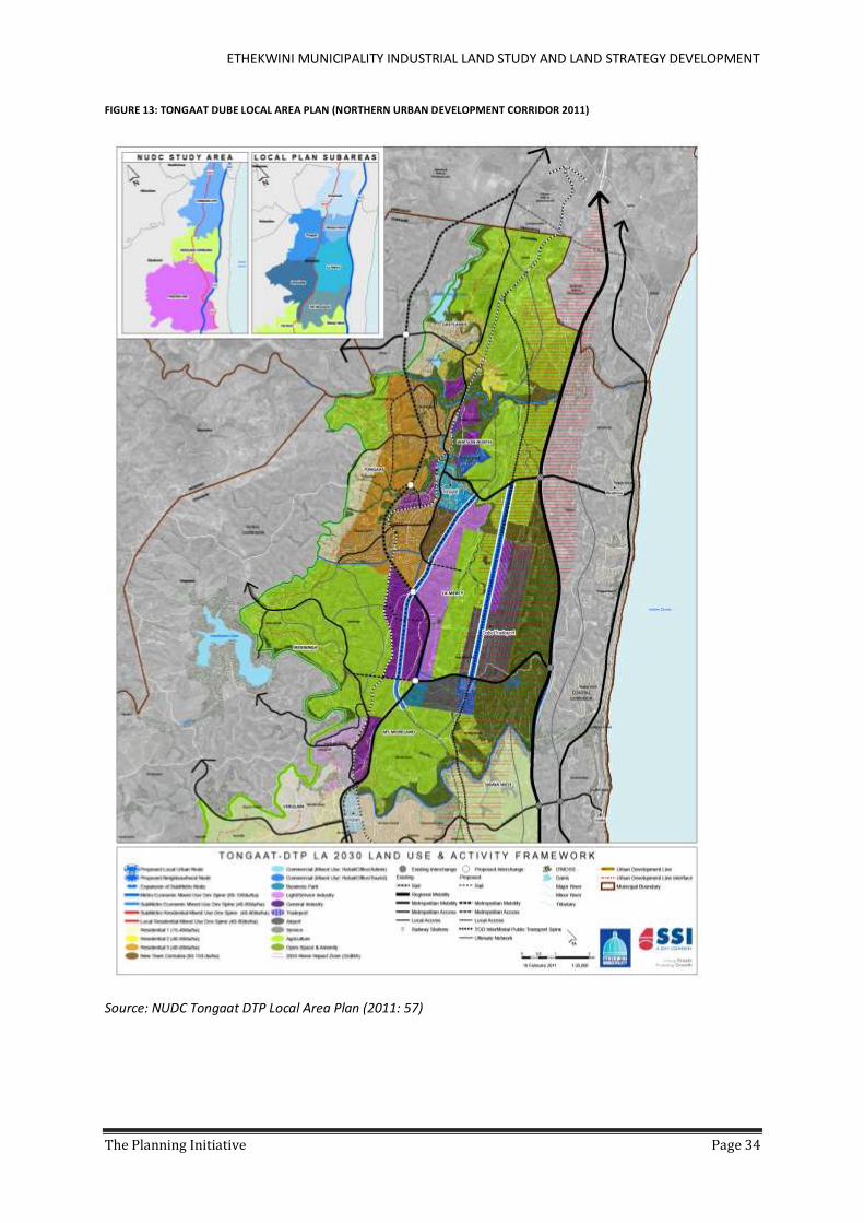
ETHEKWINI MUNICIPALITY INDUSTRIAL LAND STUDY AND LAND STRATEGY DEVELOPMENT
The Planning Initiative Page 34
FIGURE 13: TONGAAT DUBE LOCAL AREA PLAN (NORTHERN URBAN DEVELOPMENT CORRIDOR 2011)
Source: NUDC Tongaat DTP Local Area Plan (2011: 57)

ETHEKWINI MUNICIPALITY INDUSTRIAL LAND STUDY AND LAND STRATEGY DEVELOPMENT
The Planning Initiative Page 35
5.2.2.2 CATO RIDGE/HARRISON FLATS AND N3 CORRIDOR – PINETOWN, SHONGWENI,
KEYSTONE/CLIFFDALE, HAMMARSDALE, CATO RIDGE/HARRISON FLATS.
The western corridor along the N3 national route forms part of the SIP2 freight corridor and planning has
already been undertaken to identify land along this corridor for industrial development. (Refer to document
entitled: East-West Corridor: Dedicated Freight Route & Implications for the Back of Port Study Addendum
C, Iyer Urban Design Studio and Graham Muller Associates, Dec 2010 Rev 1). Areas identified in this study
include the wider Pinetown/Westmead area, Shongweni, Cliffdale/Keystone Projects, Hammarsdale,
Mpumanlanga and Cato Ridge/Harrison Flats.
The Cato Ridge Dry port forms part of a wider industrial node that has been identified between
Pietermaritzburg and Durban and lies on the main transit route between Durban and Gauteng and the SIP2
freight corridor. A significant amount of land has already been zoned for industrial development in the area,
although freeway access and some servicing issues require resolution.
FIGURE 14: CATO RIDGE LOCAL AREA PLAN (NOVEMBER 2010 FROM OUTER WEST SPATIAL DEVELOPMENT PLAN)
The Outer West Spatial Development Plan notes that
“significantly large extent of existing zoned industrial flat land (1000 ha) is located within the District,
which makes it an attractive location for industry. A key challenge for industrial development is that
most of this land falls within the uMngeni River Catchment, which contains the Inanda Dam, which is a
key source of water for the City. In order to protect the Inanda Dam from contamination from industrial
waste disposal requires that proper waste water infrastructure be in place. A second challenge is that
the anticipated traffic generation from this industrial node will have major impacts on the N3 for which
solutions must be found.
Cato Ridge, despite these challenges, offers the only opportunity to provide significant job opportunities
for the vast settlements in Fredville, KwaXimba and Mpumalanga. Coupled with the fact that it is an
important development node for port expansion related activities.”

ETHEKWINI MUNICIPALITY INDUSTRIAL LAND STUDY AND LAND STRATEGY DEVELOPMENT
The Planning Initiative Page 36
The feasibility of the Cato Ridge Dry-Port is still under discussion and there is a growing view that this is too
far away from the Seaport to have any advantage for logistics related to the seaport. Nevertheless the
amount of flatter land and the location of the area on the road and rail route between Durban-
Pietermaritzburg and ultimately Gauteng indicates opportunity for industrial development in this area,
which is already being demonstrated through the recent growth in the area.
Given the fact that the area is largely Greenfields, already accommodates some noxious industry and is
reasonably remote from residential areas it may be an appropriate area to explore for the development of
Noxious Industry. Whilst there will be catchment issues to be concerned about, opportunities to plan the
area properly and to mitigate impacts exist.
Specific projects on the Dashboard list include:
Bartletts/Keystone at Cliffdale (130 ha)
Cato Ridge/Harrison Flats Industrial area and Dry Port (subject to feasibility)
Giba Business Park (56 ha)
Prioritizing the first phases of the Aerotropolis and the N3 corridor will provide a range of development
opportunities and make significant headway in delivering on the land bank concept.
5.2.2.3 THE DIG-OUT PORT AND SOUTHERN AREAS
The Dig-out Port, whilst having received approval in principle, still requires environmental assessment and
funding support, as well as further forward planning based on the work already completed in the Back of Port
Local Area Plan (May 2012 Rev 5). Road access will no doubt require significant upgrades as well servicing
capacity.
FIGURE 15: BACK OF PORT LAND USE STRUCTURE
Source: (Iyer Urban Design and Graham Muller Associates 2012)
5.2.2.4 SUMMARY
From this overview the priorities are reasonably obvious. The first priority should be the release of land around
the new international airport followed by the Cato Ridge area and then the south dry port area.
ETHEKWINI MUNICIPALITY INDUSTRIAL LAND STUDY AND LAND STRATEGY DEVELOPMENT
The Planning Initiative Page 37
Having identified these priorities does not imply, however, that other areas should be ignored. Given the lengthy
planning and approval cycles, other identified areas such as Illovo South, Shongweni and Finningly should still
be given attention. On-going planning is imperative to ensure that these areas are ready to come on stream as
market demand requires.
5.2.3 DECISIVE BUSINESS AND POLITICAL CULTURE AND EXEMPLARY URBAN MANAGEMENT The proposed prioritization of Industrial areas for catch-up will need
1. To be approved by the Strategic Deal making team and these decisions communicated to the
Municipal Departments
2. Have dedicated project managers appointed or their mandates confirmed and if necessary
expanded if they are already in place
3. Have dedicated development project meetings set up for each project to provide a forum to
unblock issues
4. These projects should become standing items on the Inter-departmental approval teams
agenda to ensure constant attention
The on-going planning and development of industrial areas needs to be taken through the communication
channels and approval committees set out in the Strategy to ensure ongoing delivery of an industrial land bank
into the future.
5.2.4 PROACTIVE INFRASTRUCTURE DELIVERY The proposed prioritization of Industrial areas for catch-up will need
1. Infrastructure issues, many of which are already identified in the various planning and
infrastructure documents, to be taken to the interdepartmental approval team for discussion
and resolution.
2. Where Provincial or National input is required this should be taken to the Strategic Decision
making team to take up to the highest level in the Government structures for resolution.
On-going planning will require updating the SDF and alignment with the BEPP to identify future infrastructure
requirements. Extending the budgeting process to take account of longer term infrastructure requirements has
already been identified by the Engineering team and needs to be emphasized through this process to bring these
projects onto the agenda earlier than is currently the case with the 3 year budget cycle.
5.2.5 INNOVATION, RESEARCH AND DEVELOPMENT The proposed prioritization of Industrial areas for catch-up will need
1. The prioritization of the Strategic Environmental Plan in firstly, the Aerotropolis area and
secondly, the Cato Ridge and N3 corridor areas. This is required to highlight the environmental
issues earlier in the process, and identify the possibility of regional mitigation and off-sets
which could then be tested and piloted as part of the SEP process.
2. The Municipal LUMS team should also focus their attention on resolving Act 70 of 1970 issues
with the National and Provincial Departments in the priority areas.

ETHEKWINI MUNICIPALITY INDUSTRIAL LAND STUDY AND LAND STRATEGY DEVELOPMENT
The Planning Initiative Page 38
5.3 THE SPATIAL APPLICATION OF THE STRATEGIES BY PLANNING REGION AND INDUSTRIAL SUBURBS Section 5.1 and 5.2 have outlined the prioritization of projects within the Brownfields and Greenfields areas of the Metropolitan area. These priorities have been summarised
into the table of industrial suburbs that were used in compiling the GIS database (Table 4). In addition comment has been made about each of the suburbs in order to
complete the Industrial Land Strategy.
Column 2 of Table 4 suggest a categorization of each Industrial Suburb based on the team’s knowledge of the area and the information from the GIS database. An
explanation for each category is as follows:
Brownfields – areas that are zoned for industrial use, serviced and developed but are deteriorating and therefore not attracting the development that should be
expected and may as a result be experiencing increased vacancy rates i.e. are in need of intervention to retain and attract development.
Greenfields – those already identified in the Spatial Development Frameworks but have no industrial development rights and are not serviced.
Developed - industrial areas that are performing well and require sustained good urban management in order to protect the performance of the areas with
minimal additional interventions.
TABLE 4: INDUSTRIAL LAND STRATEGY BY PLANNING REGION AND SUBURB
Area Category (see notes above)
Existing Floor Area 2012 (Ha)
Total Existing
Land Area (Ha)
Total Planned Area –
industrial and business park (Gross)
(Ha)
Main Issues identified to date (further work may
uncover additional issues)
Possible Intervention (requires more
detailed work through implementation state
to confirm)
Priority
NORTH
Phoenix Brownfields 66 221 0 B&RE programme established; Support for establishing a SRA and UIP in the future.
UMZ that recognises the role of the economic hub for industrial purposes
Brownfields Priority as a current project to roll over funding.
Briardene/ North Coast Rd
Developed and Greenfields
39 146 0 Corobrik redevelopment – issues are Roads with SANRAL and Electricity, whilst Water is less of a problem
Appoint project manager and set up Operational Developers Forum meetings
Part of Northern Corridor so should be considered with Greenfields Priority 1
Tongaat including part
Some developed and Greenfields
23 80 1 001 Bulk Infrastructure and approvals
Tongaat – possible UIP or UMZ that recognises
Greenfields Priority 1

ETHEKWINI MUNICIPALITY INDUSTRIAL LAND STUDY AND LAND STRATEGY DEVELOPMENT
The Planning Initiative Page 39
Area Category (see notes above)
Existing Floor Area 2012 (Ha)
Total Existing
Land Area (Ha)
Total Planned Area –
industrial and business park (Gross)
(Ha)
Main Issues identified to date (further work may
uncover additional issues)
Possible Intervention (requires more
detailed work through implementation state
to confirm)
Priority
of the area around the Dube TradePort - Dube Aerotropolis
the civic, business, transport and specialist roles. Fast track infrastructure approvals and implementation; fast track environmental and planning approvals through structures suggested in Strategy 1.
Cornubia Identified Greenfields
1 30 294 In progress Tongaat Hulett Developments – mostly sold. Cornubia Industrial is delayed with buyers/end users wanting to come, but not able to because of the inability to connect to sewer.
Appoint a project facilitator to address.
Verulam South
Brownfields 5 30 0 UIP; UMZ that recognises the civic, business, transport and specialist roles.
Verulam/Canelands/ Inyaninga including part of the area
Small Brownfields and including large Identified Greenfields
25 80 1 188 Bulk Infrastructure and approvals
Fast track infrastructure approvals and implementation; fast
Greenfields Priority 1
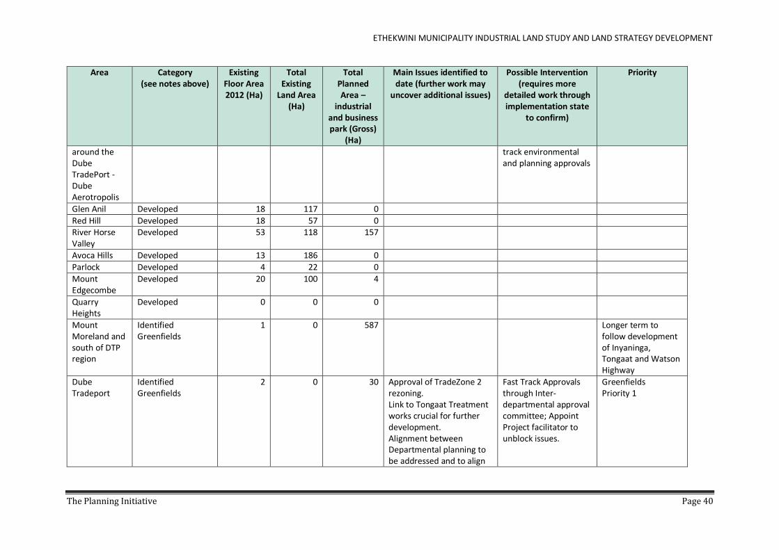
ETHEKWINI MUNICIPALITY INDUSTRIAL LAND STUDY AND LAND STRATEGY DEVELOPMENT
The Planning Initiative Page 40
Area Category (see notes above)
Existing Floor Area 2012 (Ha)
Total Existing
Land Area (Ha)
Total Planned Area –
industrial and business park (Gross)
(Ha)
Main Issues identified to date (further work may
uncover additional issues)
Possible Intervention (requires more
detailed work through implementation state
to confirm)
Priority
around the Dube TradePort - Dube Aerotropolis
track environmental and planning approvals
Glen Anil Developed 18 117 0
Red Hill Developed 18 57 0 River Horse Valley
Developed 53 118 157
Avoca Hills Developed 13 186 0
Parlock Developed 4 22 0
Mount Edgecombe
Developed 20 100 4
Quarry Heights
Developed 0 0 0
Mount Moreland and south of DTP region
Identified Greenfields
1 0 587 Longer term to follow development of Inyaninga, Tongaat and Watson Highway
Dube Tradeport
Identified Greenfields
2 0 30 Approval of TradeZone 2 rezoning. Link to Tongaat Treatment works crucial for further development. Alignment between Departmental planning to be addressed and to align
Fast Track Approvals through Inter-departmental approval committee; Appoint Project facilitator to unblock issues.
Greenfields Priority 1

ETHEKWINI MUNICIPALITY INDUSTRIAL LAND STUDY AND LAND STRATEGY DEVELOPMENT
The Planning Initiative Page 41
Area Category (see notes above)
Existing Floor Area 2012 (Ha)
Total Existing
Land Area (Ha)
Total Planned Area –
industrial and business park (Gross)
(Ha)
Main Issues identified to date (further work may
uncover additional issues)
Possible Intervention (requires more
detailed work through implementation state
to confirm)
Priority
with approved Spatial Plans.
Watson Highway – Ushukela
Identified Greenfields
0 0 1 127 Infrastructure and approvals
Fast track infrastructure approvals and implementation; fast track environmental and planning approvals through Interdepartmental approval committee and assistance of project manager
Greenfields Priority 1
1 188 4 389
SOUTH Umbogintwini Developed 51 167 0
Southgate Developed 41 174 0
Isipingo Brownfields 22 0 0 UIP; UMZ that recognises the civic, business, transport and specialist roles.
Brownfields Priority 1
Prospecton and Dig-out Port (estimated 334 ha of surface water and
Brownfields – partly Greenfields with new dug-out port
190 712 0 UMZ that recognises the role of the economic hub for industrial purposes
Brownfields Priority 1 Dib-out Port Greenfields Priority 3/medium term

ETHEKWINI MUNICIPALITY INDUSTRIAL LAND STUDY AND LAND STRATEGY DEVELOPMENT
The Planning Initiative Page 42
Area Category (see notes above)
Existing Floor Area 2012 (Ha)
Total Existing
Land Area (Ha)
Total Planned Area –
industrial and business park (Gross)
(Ha)
Main Issues identified to date (further work may
uncover additional issues)
Possible Intervention (requires more
detailed work through implementation state
to confirm)
Priority
435 ha of port area)
Lower Illovu Identified Greenfields
1 0 128 Greenfields Priority 3
Umkomaas Developed and small Identified Greenfields
9 81 12
Craigieburn including Finningley Estate
Brownfields and Identified Greenfields
1 5 40 More industrial land likely to be identified in future
Medium term
1 139 180
CENTRAL
City And Port
CBD Brownfields 166 25 0 Identified as an UMZ that includes a business hub, transportation and tourism roles; UDZ
Brownfields Priority 2
Point Terminal Developed 14 84 0
Maydon Wharf
Developed 57 150 0
Bayhead Developed 21 109 0
Port: Piers 1-2 & Island View
Developed 49 555 0
Mayville Developed 5 10 0
Umgeni Road Brownfields 41 12 0 Facilitation role with stakeholders to support
BE&RP /UIP Brownfields Priority 2

ETHEKWINI MUNICIPALITY INDUSTRIAL LAND STUDY AND LAND STRATEGY DEVELOPMENT
The Planning Initiative Page 43
Area Category (see notes above)
Existing Floor Area 2012 (Ha)
Total Existing
Land Area (Ha)
Total Planned Area –
industrial and business park (Gross)
(Ha)
Main Issues identified to date (further work may
uncover additional issues)
Possible Intervention (requires more
detailed work through implementation state
to confirm)
Priority
establishment of local forum
Bayhead South
Developed 63 465 0
Seaview Developed 4 16 0
Coedmore Developed 3 70 0
South Durban Basin
Clairwood Brownfields 51 131 0 Facilitation role with broader stakeholders to support establishment of local forum; Conflict between residential amenity and industrial roles
BE&RP/UIP Brownfields Priority 1
Mobeni Brownfields 78 196 0 Facilitation role with industrial stakeholders to support establishment of local forum
BE&RP/UIP Brownfields Priority 1
Jacobs Brownfields 118 269 0 Facilitation role with industrial stakeholders to support establishment of local forum
BE&RP/ UIP Brownfields Priority 1
Mondi Developed 11 38 0
Stanvac Developed 18 93 0
Durban Central
Congella Brownfields 96 247 0 Facilitation role with stakeholders to support
BE&RP/ UIP Brownfields Priority 2

ETHEKWINI MUNICIPALITY INDUSTRIAL LAND STUDY AND LAND STRATEGY DEVELOPMENT
The Planning Initiative Page 44
Area Category (see notes above)
Existing Floor Area 2012 (Ha)
Total Existing
Land Area (Ha)
Total Planned Area –
industrial and business park (Gross)
(Ha)
Main Issues identified to date (further work may
uncover additional issues)
Possible Intervention (requires more
detailed work through implementation state
to confirm)
Priority
establishment of local forum
Springfield Park
Developed 90 238 0
Woodhurst Developed 2 22 0
Silverglen Developed 3 0 0
Claire Estate Developed 0 0 0
Palmiet Quarry
Developed 0 0 0
Chesterville Developed 0 54 0
Inner West
New Germany Brownfields 134 374 0 Process needs to be linked to sustaining interventions such as a SRA and UIP
BE&RP/ UIP Brownfields Priority 3
Pinetown Brownfields 47 93 0 Process needs to be linked to sustaining interventions such as a SRA and UIP
Identified as an UMZ that includes a business hub, transportation and tourism roles
Brownfields Priority 3
Westmead Brownfields and Greenfields
170 523 0 Westmead Giba Business Park – Greenfields – additional area to be rezoned; Some access issues on existing brownfields areas
UIP Fast track approvals through Inter-departmental approval committee and appoint Project Manager to unblock issues
Brownfields Priority 3 Westmead Greenfields Priority 2 Giba Business Park
Queensburgh Developed 24 184 0
Shallcross Developed 15 78 0

ETHEKWINI MUNICIPALITY INDUSTRIAL LAND STUDY AND LAND STRATEGY DEVELOPMENT
The Planning Initiative Page 45
Area Category (see notes above)
Existing Floor Area 2012 (Ha)
Total Existing
Land Area (Ha)
Total Planned Area –
industrial and business park (Gross)
(Ha)
Main Issues identified to date (further work may
uncover additional issues)
Possible Intervention (requires more
detailed work through implementation state
to confirm)
Priority
Sarnia/ Paradise Valley
Developed 0 0 0
CENTRAL TOTAL
4 036 0
OUTER WEST
Hammarsdale Brownfields and Identified Greenfields
53 281 335 UMZ that recognises the role of the economic hub for industrial purposes;
Brownfields Priority 2
Cato Ridge Brownfields and Identified Greenfields
50 289 688 Greenfields Priority 2
Waterfall Developed 8 38 0
Marievale 0 0 0
Upper End Of Langefontein
Developed 1 0 0
Bothas Hill Developed 1 0 0
Hillcrest Developed 1 0 0
Winston Park Developed 1 0 0
Keystone Park / Bartletts
Identified Greenfields
0 0 0 Several infrastructure issues to resolve including involvement of SANRAL in interchange issues
Need to appoint a project manager within the Municipality and establish developers forum to take issues forward
Greenfields Priority 2
Dry Port Identified Greenfields
0 0 5 Feasibility still in question Feasibility to be fast tracked and fully
Greenfields Priority 2

ETHEKWINI MUNICIPALITY INDUSTRIAL LAND STUDY AND LAND STRATEGY DEVELOPMENT
The Planning Initiative Page 46
Area Category (see notes above)
Existing Floor Area 2012 (Ha)
Total Existing
Land Area (Ha)
Total Planned Area –
industrial and business park (Gross)
(Ha)
Main Issues identified to date (further work may
uncover additional issues)
Possible Intervention (requires more
detailed work through implementation state
to confirm)
Priority
debated with the Private Sector in the light of the back of Port study
OUTER WEST TOTAL
608 1 028

ETHEKWINI MUNICIPALITY INDUSTRIAL LAND STUDY AND LAND STRATEGY DEVELOPMENT
The Planning Initiative Page 47
6 INSTITUTIONAL RESPONSES AND FINANCIAL ISSUES
6.1 INSTITUTIONAL RESPONSES FOR ACCELERATED, LOWER-PRICED INDUSTRIAL LAND AND
DELIVERY Two roles appear to be emerging for the City
1. Making the City Systems work better to facilitate industrial development
2. Taking an active role in providing industrial land
At the second stakeholder workshop at Moses Mahbida Stadium in March 2014, the TPI team discussed and
tested at least five broad institutional options for possible interventions designed to accelerate the delivery of
low priced (but still high quality) industrial land. These options and their initially conceived advantages and
disadvantages are summarised in the table below.
The underlying assumption of the table is not that only one particular response should be chosen. It is possible
for several to be implemented in parallel. Moreover the table assumes that in all cases the municipal process
reforms referred to in Sections 4 of this report are adopted. However, the table below does allow us to begin a
process of understanding where the weight of future municipal proactive effort ought to lie.
Following stakeholder inputs at the abovementioned workshop as well as discussions with senior municipal
officials, there has been something of a process of elimination of the first two options, and a deepening of
understanding of the complexities and relative importance of the last three. For this reason we briefly discuss
the first two together, followed by more detailed reflections upon the last three, and then we conclude with the
team’s recommendations for future municipal action.
TABLE 5: POSSIBLE INSTITUTIONAL RESPONSES
Type Do Nothing Intervene in
Market Forces JV/PPP with Private
Sector Players Establish Municipal
Land Company Third Party Facilitation
Pros ‘Do no further harm’
Could bring prices down
Could bring prices down, get better options on market
Could bring prices down, speed delivery up, widen range of market options
Internationally successful re. speed
Cons Continue with current problems
Unintended market consequences in medium term
Complicated politically/legally
Could ‘panic’ market, and put municipal institutional culture to test
Retains existing market distortions
In all Optimize municipal decision making and modify practices as suggested in Section 4
6.1.1 DOING NOTHING AND MARKET INTERVENTIONS The first available option to the Municipality is to do nothing further than it already is, under the assumption
that that there is a land policy equivalent to that section of the medical Doctor’s Hippocratic Oath which says -
‘above all do the patient no further harm’. The positive aspect of this option is that all the possible negatives
(Cons) of the other four options are avoided. The negative consequence is that the problems which gave rise to
the need for the present enquiry (and possibly others) are perpetuated. As such, this option tends to dismiss
itself, at least insofar the Terms of Reference for the present study are accepted. Moreover, since the TPI team
has found that industrial land prices in Durban do indeed seem to have become inflated, it would be prudent to
at least consider ‘doing something’ to make eThekwini more competitive on this front.

ETHEKWINI MUNICIPALITY INDUSTRIAL LAND STUDY AND LAND STRATEGY DEVELOPMENT
The Planning Initiative Page 48
A conclusion that might be derived from the last mentioned observation (rising prices) could lead to a second
intervention option. Crudely put, if prices are rising, a remedy some might foresee is to punish/tax the sellers,
and/or subsidise buyers. This second option, then, might be seek, for example, to subsidize the municipal
infrastructure component of land costs for industries, and - in parallel – it might seek to impose especially high
agricultural or vacant land Municipal Rates on land owners prior to any potential industrial land’s conversion
into actual industrial land sales. In effect, then, such measures would goad land owners not to ‘hoard’ land but
rather to ‘flood’ the market, which the municipality could then seek to facilitate through blanket EIA approvals
and re-zonings. Flooding and speeding the market should then – in theory – reduce serviced land prices.
Carefully designed, a mix of some such interventions could bring prices down, perhaps even substantially. The
difficulties (Cons), however, are that operationalizing such models harmoniously may prove well-nigh impossible
(Appendix G: Note 1), and there could be several undesirable unintended consequences, for example rapid
scaling back of involvement by experienced industry players due to diminished margins, and thus only poor
quality options emerging on the market in the medium term.
In summary, therefore, doing nothing or trying to implement radical land market interventions seem weak
candidates for municipal prioritisation.
6.1.2 JOINT VENTURES (JVS)/PUBLIC PRIVATE PARTNERSHIPS (PPPS) A third option is for the municipality to enter into JV’s or PPPs with a range of public and private sector partners
to expedite serviced industrial land supply in attractive places. This has already been done effectively in the past,
for example at Riverhorse Valley.
A difficulty, in the present context, with Riverhorse Valley of course is that whilst it was successful on so many
dimensions, the prices of land there reached record highs. However, if it was repeated, and adapted, but now
on an extensive scale, this option could have the effect of speeding up supply of good quality stock.
Having said this, PPPs are nowadays (2013/4) often seen as too complicated by many levels of government, and
there is thus poor appetite for it. In addition many possible JVs are likely to be potentially fall afoul of the
Municipal Finance Management Act, Act No 56 of 2003.
Nevertheless, the prospect of putting more leasehold options with top-structure onto the market via municipal
or other public sector involvement in a SEZ/IDZ/EPZ for example, as happens in Richards Bay (and in some other
areas and countries), should still likely be entertained in eThekwini.
Some elaboration on this possibility is worthwhile here. The prospect of a new SEZ in Durban could offer new
opportunities for an extensive new land development JV/PPP involving several parties. This could require
eThekwini building an overarching institutional home for industrial land marketing and development within
and without an eThekwini SEZ. Its functions could be directed not only at land development and sales, but also
at place-marketing, facilitating planning permissions and infrastructure supply.
“Underneath” this over-arching institutional home for eThekwini industrial land marketing and development
could be several localised PPP/JVs, and/or individual private initiatives, each differently structured to achieve
specific purposes in particular sub-areas. Thus one could have one eThekwini- branded industrial marketing
‘umbrella home’ for a range of different industrial land sub-projects, each with their own modes of governance
and funding. This would likely need to be correlated with choices to be made on where to focus municipal
infrastructure for industrial land, which needs (for economy reasons) to concentrate in just a few nodes.
In summary, JVs and PPPs for industrial land delivery are domains in which eThekwini has good experience, but
this experience may need to be adapted, and possibly widened. However, several senior municipal and
provincial officials have made the point that PPPs and JVs can actually slow projects down and complicate them,

ETHEKWINI MUNICIPALITY INDUSTRIAL LAND STUDY AND LAND STRATEGY DEVELOPMENT
The Planning Initiative Page 49
rather than speed them up if they are ill-conceived. We therefore suggest a cautious approach which starts with
asking the questions, “do we really need a PPP/JV; and if so why?” (Appendix G: Note 2).
In this regard it is worth noting that often provincial and national government co-operation and collaboration
has been required to make such initiatives successful, and we need to ask what has been learned from those
experiences (Appendix G: Note 3). Indeed, before proceeding with any major PPP or JV on industrial land, a
beginning point would likely need to be interactions with National Treasury, a process which we understand to
have already begun as of May 2014.
6.1.3 A MUNICIPAL LAND COMPANY As may be determined from the previous section and its extensive notes in Appendix G, JVs/PPPs can be quite
complex and usually require extensive national government cultivation and support. In such a context, if
complexity is a detractor, something that is almost or completely owned by the municipality may be more
attractive. One example here is a municipal land company.
Municipal land companies which actually develop and market industrial land are rare in South Africa, but they
exist in several countries. In those countries they have the advantage of at least offering the policy option of
bringing down industrial land prices, speeding land delivery and widening (e.g. to less profitable, yet end-user
preferred formats). However, these public companies do not apparently exist in South Africa, and under certain
circumstances ‘creating a precedent’ in eThekwini could invite intervention from other tiers of government.
However, a municipal land company need not be radical and entail ‘blue sky’ thinking. For example: The Real
Estate Unit of the eThekwini Municipality already has experience in near full-service land development and
marketing (see discussion below of Kingsmead Office Park); and in its plans for the Centrum site, for example,
the Municipality is contemplating marketing commercial space that it develops.
In addition, the municipality is currently contemplating Land Banking for residential and commercial uses at
selected nodes. As yet, similar involvement in industrial land is not being contemplated, partly because of
aversion to perceived associated risks, and partly due to the existence already of experienced, successful private
developers/marketers in this metropolitan area. Overall, the feeling appears to be that, at this stage, a full-blown
municipal industrial land company could be incongruent with the current municipal experience and culture, and
that there may be weak appetite for it.
Having said this, there is extensive eThekwini municipal experience with entities akin to municipal land
companies. The Springfield Park industrial area is a good example of this, although there were some private
sector ‘junior partners’ also involved in that development. Springfield was attractive in the market place, so
criticisms of lack of market sensitivity need not apply; moreover, there were efforts afoot at the time of writing
to expand land supply around Springfield by extending the site on its margins. Hundreds of businesses operate
in Springfield today, mainly medium sized Durban or national firms, so the model is hardly one frowned upon by
the market.
In addition to this, there is extensive recent municipal experience in developing municipal land, for example at
the Kingsmead office park. Aspects of this experience could be built upon and extended, for example through
so-called municipal land banking, as contemplated by the eThekwini Real Estate Unit. This approach could in the
future be built upon to extend it into the industrial land sphere.
An opportunity to do this, and indeed go beyond it in some ways, may come through the forthcoming eThekwini
Eco-Industrial Park initiative at Cornubia. If this was done, it is likely that there would be a need to learn more
from international experience, for example from Europe and North America where municipal industrial land
banking and industrial land development is fairly advanced, where eco-industrial parks are established and
numerous, and have good reputations (Appendix G: Note 4).

ETHEKWINI MUNICIPALITY INDUSTRIAL LAND STUDY AND LAND STRATEGY DEVELOPMENT
The Planning Initiative Page 50
6.1.4 THIRD PARTY FACILITATION It could be that all of the options discussed above (with the exception of extensions of activities already being
explored by the municipality, like land banking) may be deemed to be too complex, legally or institutionally, to
address what might be seen as a relatively isolated variable like inflated land costs. This isolated variable, the
research in the present project has shown, is mainly a product of supply constraints, partly attributed to a lack
of conclusion of agreements between private developers and public regulators, including the municipality.
The municipality’s own ‘development dashboard’, in its right hand columns where the causes of project
blockages are diagnosed, often identifies bureaucratic constraints to land release like EIAs and zoning. But it
also diagnoses the problem of blockages in many projects as being that of an absence of project managers
and/or ‘champions’. This is likely a crucial point. Bureaucracy is a world-wide problem. Internationally it has
been found that time and energy needs to be devoted to ‘unblocking’, and this often requires sustained effort
by a corps of development professionals who are not directly answerable to either municipal line departments
or private developers.
Thus, a fifth municipal option for eThekwini would be to co-sponsor the use of trusted, experienced and
independent third parties (i.e. parties trusted by both public and private sectors) to act as development
facilitators for the release, development and marketing of industrial land.
eThekwini has inherited something of the adversarial British ‘private-sector-proposes, public-sector-disposes’
regime for industrial land processes. However, other international models exist which use third parties
effectively, and South Africa has experience with using such development facilitators in other land development
contexts. The IDT’s (Independent Development Trust) successful use, during the 1990s, of third party ‘soft’ and
‘hard’ consultants, to avoid ‘ Nimby-ism’ and advise on the direction of capital subsidies for low income housing,
springs to mind(See Appendix G: Note 5). Usually such consultants both facilitated and ‘championed’ particular
low income housing and/or informal settlement upgrade projects, and ‘made them their own’.
A possible criticism of this fifth model is that, unless they are empowered to speed up delivery (the now
emasculated Development Facilitation Act assisted the IDT consultants with dispatching of bureaucracy), with
powers for example to acquire land from possibly reluctant sellers (at least at attractive prices), then these actors
might have little effect on existing market distortions. At the very least, however, eThekwini might initiate a
more detailed feasibility analysis into the local prospects for such a model.
Such models have actually been the norm for facilitating industrial land delivery in some countries, and perhaps
that experience could be built upon. The prime example here is France. Although until the 1980 French policy
on industry and industrial land was fairly highly centralised, in the last three decades there has been much
greater involvement of both Municipalities, District Councils and their Chambers in both industrial land assembly
and development and ‘place marketing’. Central forces in bringing such parties together are in fact a set of
relatively independent development facilitators (See Appendix G: Note 6).
Possibly some adaptation of this model should be tried and tested in the eThekwini case. This would be
consistent with the eThekwini ‘development dashboard’s diagnosis that many blocked projects are a result of a
lack of project managers or ‘champions’.
However feedback at both stakeholder workshops suggest that this (and other) options should also be
complemented by another area of activity – internal municipal reform, particularly of the development control
functions of the municipality. Reviewing the notes of the workshops, much of the commentary from participants
related to how there appeared to be unnecessary delays and blockages to planning and implementation of land
release by different components of the municipality.

ETHEKWINI MUNICIPALITY INDUSTRIAL LAND STUDY AND LAND STRATEGY DEVELOPMENT
The Planning Initiative Page 51
6.2 INSTITUTIONAL CONCLUSIONS AND RECOMMENDATIONS It would be wrong to assume that there can be a ‘silver bullet’ in the institutional domain to facilitate industrial
land delivery, which would lower prices whilst holding quality constant. In particular, a ‘quick fix’ approach is
unlikely to work. The problems faced today have been building up over decades, and will likely take at least a
decade to resolve.
That said, beginning now with new interventions does seem urgent, given the weight of evidence presented
elsewhere in this report, and in previous reports. There could be a range of interventions, pursued in parallel,
which should be preceded in the immediate term with three feasibility studies relating to the three options
discussed in great depth above.
That is, the municipality should commission feasibility studies into:
(i) The scope and nature of an eThekwini Industrial Land Marketing and Development Consortium,
involving the key municipal, para-statal and private sector parties currently engaged in the industrial
land release field. The purposes of this Consortium should centre on supplying speed and comparative
value-for-money in the field of industrial land supply.
(ii) The scope and limits for extending current successful municipal initiatives in land banking, land
preparation and land release into the sphere of industrial and warehousing land (perhaps growing out
of and extending the Eco-Industrial Park initiative).
(iii) The adaptation of successful South African and international cases of the use of third party facilitators
to expedite the release of industrial land in the eThekwini area.
It would not seem unreasonable to expect that these three activities could be completed within a year, and then
form the foundations for medium and long-term interventions. These would be interventions which undermine
the current causes of the lack of availability and relatively high price of good quality industrial land.
6.3 FINANCIAL CONSIDERATIONS A key financial consideration for the municipality in relation to industrial land pertains to the opportunity to
expand municipal rates income. At present 46% of the City budget is funded from the rates base, a large
proportion of which comes from residential properties. Increased industrial development within the City will
assist in shifting the burden away from the Residential rate payer. Moreover, industrial development presents
other possible sources of revenue present themselves, as was the case with Riverhorse Park Business Estate.
The acquisition of raw land, EIA and rezoning costs, site servicing and preparation for sale, and marketing of
industrial land, amongst other considerations are, however, not a simple business financially. It involves risk,
borrowing, and taking views on expected returns in often uncertain markets.
Any strategy for a more pro-active role by eThekwini in respect of industrial land release cannot therefore be
expected to be financially-neutral, and in this regard it will be important to situate the proposals here for
example in relation to the current IDP and future IDP reviews, and especially in relation to their budgetary
aspects.
The financial implications of our proposals are all intended to be positive for eThekwini, but some detailed
financial modelling will be necessary in relation to sub-components of it, and in relation, assessing the relative
merits for example, of different institutional options. In other words ‘due diligence’ studies may be required,
once policy-preferred options have been identified.
Having said this, eThekwini has inevitably been making risky investments anyway in various areas, and some
lessons from eThekwini’s own experiences with the industrial land component, and those of other cities, may
help to orientate future work in this regard.

ETHEKWINI MUNICIPALITY INDUSTRIAL LAND STUDY AND LAND STRATEGY DEVELOPMENT
The Planning Initiative Page 52
In relation to eThekwini, probably the most useful financial reference point to start with would be that of their
experience with Riverhorse Valley Business Estate (RHVBE). The findings of a recent independent review of
RHVBE done for eThekwini Municipality may be useful in this regard. A summary of the financial aspect of the
findings was as follows:
‘A total of R215.7 million, of which eThekwini made roughly a two-thirds contribution, was spent on
establishing and servicing the Estate (this excludes top structure development). To place this in context
this investment must be compared to public sector spending on the uShaka Marine World (R735
million), the Durban ICC (R900 million in the 1990s), the Moses Mabhida Stadium (R3.4 billion) and the
King Shaka International Airport (R7.8 billion). In comparison the public sector investment in RHVBE has
thus been relatively small.
Capital investment: From calculations based on the 2012 eThekwini Municipality Valuation Roll of the
RHVBE the market value of properties in the RHVBE was estimated at R3.2 billion. Through the survey
further investment of R1.2 billion over the next five years could be confirmed. This is viewed as a
conservative estimate of the actual capital investment as it is anticipated that market value for
industrial properties will be well below the actual investment value. Again, to place this in context, the
construction of 4,000 middle income houses (each valued at R800,000) will equate this investment
value of R3.2billion. This capital investment of R3.2 billion should then also be considered in the context
of the R3.4 billion Moses Mabhida Stadium and the R7.8 billion King Shaka International Airport.
Municipal Rates Contribution: The rates contribution of properties in RHVBE is estimated to be R83
million per annum, or more than a third of the actual investment cost of R215.7 million. This will equate
to the rates contribution of 6,000 homes valued at R1.5 million each, or 11,500 homes valued at
R800 000.
Employment: Based on the survey findings it was estimated that in excess of 17,000 people are
employed in RHVBE. The permanent workforce is estimated to be 12,629 (of which 4,249 are new jobs)
augmented by a contract workforce of 4,446 people (including employees of contractors and contract
staff). Estimates from the early 2000’s placed employment in Isipingo / Prospecton at 21,000 people,
Springfield Park at 12,000 and Phoenix Industrial at 4,500. The Durban ICC is suggested to create 3,376
jobs directly related to the core activities of the Centre. Further to this, the majority of employees
employed in RHVBE are drawn from the general area in which it is located, i.e. INK (32%) and Durban
North (17%), with Reservoir Hills, Newlands and Avoca Hills making a combined 12% contribution to
employment’.1
The point that is implicitly obvious here is the municipality’s involvement in RHVBE paid off handsomely, and it
was far more prudent in financial terms than the much more high-profile Moses Mabhida Stadium or the ICC (or
indeed beachfront commercial interventions). Whilst the development of industrial land may be more
symbolically prosaic, in terms of risk and return, if properly done, it has proven probably the most prudent of
ways in which eThekwini has actually spent money in the past thirty years or so.
In terms of international experience we would remind readers especially of our previous discussion of the
Edmonton (Canada) experience here, as referred to in our Phase 1 work. More recent research by the TPI team
on the financial implications of the Edmonton Municipal pro-active approach to industrial development is worth
summarising here. In Table 5 below, we can see that money from (mainly industrial) land development is
currently, in the order of net profits measures of about R50 million p.a.; and retained earnings were over a Billion
1 STRATPLAN, RIVER HORSE VALLEY BUSINESS ESTATE DRAFT 2: IMPACT ASSESSMENT, eThekwini Municipality, November 2012

ETHEKWINI MUNICIPALITY INDUSTRIAL LAND STUDY AND LAND STRATEGY DEVELOPMENT
The Planning Initiative Page 53
Rand this year.2 Edmonton, it should be recalled, is a city with a third of the population of eThekwini, and it is
not especially industrial in economic profile by comparison to Durban.
Some key questions arise: Would it therefore be unreasonable to expect a similar eThekwini local public
company to earn R150 million p.a. in net profits? And, if so: What other economic development initiative in
eThekwini could compare, in terms of net profits?
There will be many other cities worthy of research in respect of such financials, and we would recommend
further research in this regard going forwards. In summary however, there are potential high stakes financially,
for the municipality in this domain, in additions to the other economic benefits that can be realised like jobs
through the attraction of new industries.
TABLE 6: EDMONTON MUNICIPAL LAND DEVELOPMENT ENTERPRISE FINANCIAL PROJECTIONS3
2 Assuming an exchange rate of R9 to one Canadian dollar. 3 Source:www.edmonton.ca/city_government_documents/2014_Land-Enterprise_budget.pdf

ETHEKWINI MUNICIPALITY INDUSTRIAL LAND STUDY AND LAND STRATEGY DEVELOPMENT
The Planning Initiative Page 54
7 CONCLUSION AND RECOMMENDATIONS Three primary strategies have been identified to activate a new approach to industrial land development in
eThekwini:
1. Decisive Business and Political Culture including exemplary Urban Management Practices
2. Proactive Infrastructure Delivery
3. Innovation, Research and Development
The actions required to implement them have been outlined and how the strategy should be actioned from a
spatial perspective has been suggested, together with institutional and financial options.
It is suggested that the institutional proposals and the actions recommended be taken forward by EDIPU within
the context of the Municipal restructuring process and the Best Practice City Commission investigations and
findings, and built into these processes.
The spatial recommendations should also be strongly interfaced with the SDF and Municipal package of plans
and the Integrated City Development and Built Environment Performance plan processes.
With respect to the Institutional possibilities additional feasibility studies have been identified including:
(i) The scope and nature of an eThekwini Industrial Land Marketing and Development Consortium,
involving the key municipal, para-statal and private sector parties currently engaged in the industrial
land release field. The purposes of this Consortium should centre on supplying speed and comparative
value-for-money in the field of industrial land supply.
(ii) The scope and limits for extending current successful municipal initiatives in land banking, land
preparation and land release into the sphere of industrial and warehousing land.
(iii) The adaptation of successful South African and international cases of the use of third party facilitators
to expedite the release of industrial land in the eThekwini area.
Given the evidence on the financially prudent nature of proactive eThekwini engagement in industrial land
supply at Riverhorse, and the remarkable financial success of municipal engagement in industrial land supply
elsewhere in the world, it is further recommended that the EDIPU should deepen research into such experiences,
and extrapolate their relevance for local application or adoption.
Finally the industrial land study as well as the land strategies and recommendations should be updated and
reviewed on a regular basis. The updates should be based on
Improved interdepartmental interaction with respect to research and policy formulation including the
spatial plans of the Municipality
Reflection based in the results of research projects
Updating the database and improved understanding of supply
Regular interaction with the private sector
To this end a monitoring and evaluation report will be prepared to guide the process.

ETHEKWINI MUNICIPALITY INDUSTRIAL LAND STUDY AND LAND STRATEGY DEVELOPMENT
The Planning Initiative Page 55
8 REFERENCES 1. Dixon, Tim. Raco, Mike and Catney, Philip. 2008. Sustainable Brownfield Regeneration : Liveable Places
from Problem Spaces. Wiley. Chichester, GBR.
2. Durban Investment Promotion Agency. 2011. Retaining & Growing eThekwini Business. Proposals for a
Business Retention & Expansion Strategy prepared by Gerry Delany.
3. eThekwini Municipality. 2014. Built Environment Performance Plan 2nd Draft.
4. UN-Habitat. 2009. Planning Sustainable Cities: Global Report on Human Settlements. Earthscan.
London.
5. Oliver, L. Ferber, U. Grimski,D. 3, Kate Millar, K. and Nathanail, P. 2004. The Scale and Nature of
European Brownfields accessed from http://www.cabernet.org.uk/resourcefs/417.pdf on 19 May
2014.
6. EThekwini Municipality. 2012. DRAFT BACK OF PORT INTERFACE (BOP) LOCAL AREA PLAN (LAP)
7. Presentation to ECOD prepared by Graham Muller and Iyer Design Studio.

ETHEKWINI MUNICIPALITY INDUSTRIAL LAND STUDY AND LAND STRATEGY DEVELOPMENT
The Planning Initiative Page 56
APPENDIX A: DRAFT ETHEKWINI INDUSTRIAL DEVELOPMENT STRATEGY 2012
URBANECON
Goals and Objectives
Objectives:
Goals
1. Growing the Industrial Economy
2. Developing Industries
3. Creating a conducive environment for sustainable industrial development
ESP1 Sector Development Interventions
ESP2 Investment Acceleration and Services to Businesses and Investors
ESP3 Spatial and Industrial Infrastructure Development and Upgrading
ESP4 Industrial Upgrading
ESP5 Innovation and Technology Development
ESP6 Human Resource and Skills Development
ESP7 Developing the Green Economy
ESP8 Trade Promotion and Facilitation
ESP9 Leveraging Public Expenditure and Empowerment for Growth and Development
ESP10 Coordination and monitoring, Capacity and Organisation
ESP 3: Spatial and Industrial Infrastructure Development and Upgrading
Infrastructure developments that will support industrial growth and development that the Municipality is to
undertake include:
Expansion and upgrading of the Port of Durban. The main options related to this are the increase in
efficiencies in the port and associated logistical support systems; the upgrading and redesign of
Bayhead and the re-development of the DIA site. These options are however complex and requires
careful consideration;
The development of a dedicated freight route to and from the Port of Durban. There is also a need to
explore industrial opportunities along the new freight route
Upgrading transport infrastructure and developing a transport traffic zone along the N2 between the
Port of Durban and Dube Trade Port;
Upgrading transport infrastructure at Bayhead, Clairwood, Mobeni, Jacobs, and Congella;
Providing access to new industrial development areas such as Cato Ridge, Hammarsdale, Shongweni,
and Northern areas of the Municipality by developing bulk and transport infrastructure in Cato Ridge;
Re-development of infrastructure in Hammarsdale to retain the existing industry and attract further
investment to the area

ETHEKWINI MUNICIPALITY INDUSTRIAL LAND STUDY AND LAND STRATEGY DEVELOPMENT
The Planning Initiative Page 57
Establishing a Special Economic Zone within the Municipality;
Establishing industrial parks, hi-technology development and science parks;
Facilitating catalytic project specific infrastructure; and,
Development of an industrial zone for noxious industries and hazardous waste.
Overview of key actions High Impact Industrial Development Initiatives
Sect
or
De
velo
pm
ent
Inte
rve
nti
on
s
Develop sector strategies to encourage and support growth and expansion of existing sectors
Develop sector strategies direct and facilitate expansion into new industries
Enhance value-add to production and make the expansion into high technology manufacturing
Inve
stm
ent
Acc
ele
rati
on
Investment attraction activities to focus in attracting investors and facilitating expansion of existing industries
Efficient services should be provided to businesses in order to facilitate new investments as well as retain and expand existing businesses
Exp
ort
ori
enta
tio
n a
nd
tra
de
faci
litat
ion
Enhance trade capacity of Port of Durban to support cost-efficient exports and imports, establishing Durban as the major trade gateway into Southern Africa
Trade capacity development to focus on:
Attracting new maxi container ships subject to port capacity (would yield substantial local spending on services and establish Durban as the hub-port for Southern Africa);
Fostering efficient shipping/transport/logistics system to attract investments in import/export oriented manufacturing projects;
Establishing an inland container terminal at Cato Ridge would help smooth traffic flows and facilitate increasing the trade capacity of Port of Durban. This is because it would shorten turnaround times for long haul transport carriers.
Development of rail network would facilitate increasing the trade capacity. Establish a Special Economic Zone for the manufacturing industry
Investigate opportunities in establishing a Trade Centre in Durban
Spat
ial a
nd
Infr
astr
uct
ure
de
velo
pm
ent
Improve transport and logistics network
The development of the DIA land into a Dig-Out Port
Support the future interim use of the DIA site as an ICT Precinct Develop high potential priority nodes to provide land for industrial development;
Hammarsdale to grow to full spatial capacity with strong emphasis on Textiles, Clothing and Footwear manufacturing and other labour intensive industries;
Cato Ridge / Harrison Flats to accommodate heavy industries and Logistics Park;
Other nodes include: Bayhead, Clairwood, Mobeni and Jacobs in which redevelopment of transport and logistics facilities are most suitable.
Develop a dedicated freight route to and from the Port of Durban
Explore industrial opportunities along the new freight route Establish manufacturing supplier park for Automotive Manufacturing and a hub for Clothing and Textiles Manufacturing
Develop industrial infrastructure required to enhance efficiencies and competitiveness
Development of Cornubia – Phase 1 of project
Skill
s ,
Inn
ova
tio
n
and
Te
chn
olo
gy
Dev
elo
pm
ent Skills development in terms of existing and future industry needs within traditional and non-traditional industries
Support innovation and technology development to enhance competitiveness of existing industries and facilitate the expansion into new industries

ETHEKWINI MUNICIPALITY INDUSTRIAL LAND STUDY AND LAND STRATEGY DEVELOPMENT
The Planning Initiative Page 58
Establish skills hubs, incubators, testing centres and centres of excellence as modes to achieve skills development in various sectors
Gre
en
Ind
ust
ries
an
d
Envi
ron
me
nta
l Su
stai
nab
ility
Promote implementation of environmentally friendly production processes
Implement projects for alternative energy generation
Facilitate expansion of green economy
Promote energy efficiency and conservation practices
Alignment of the green economy to economic development objectives

ETHEKWINI MUNICIPALITY INDUSTRIAL LAND STUDY AND LAND STRATEGY DEVELOPMENT
The Planning Initiative Page 59
APPENDIX B: EXTRACT FROM ECONOMIC DEVELOPMENT STRATEGY AT THE HEART OF ETHEKWINI’S ECONOMIC STRATEGY IS A ‘STEP CHANGE’ IN ECONOMIC LEADERSHIP
What does this step change mean in terms of decision making and the way in which the Municipality approaches
its business? This is discussed below in term of seven key areas. The approach under each scenario is outlined.
It is important to note that these are key areas and this change will not be limited to this, but should ultimately
filter through every business-process within the Municipality.
KEY AREA FLOAT CHOKE FLY STEP CHANGE
Strategic Investment
Strategic decisions made operationally – “why should this not happen” approach
Driven by external forces
Strategic decisions made strategically – Forum to resolve issues and look at how can the right investments be made possible
Operational to strategic ‘Can’t do’- to – ‘can do’
Infrastructure Address social backlogs. Lack of funding for economic infrastructure
No expansion, protect areas against development. Long-term phasing for infrastructure. Sweat existing assets only Fixing problems
PPPs for infrastructure provision. Expand base & sweat infrastructure. New areas for expansion and develop regional approach e.g. PTN-Pmb development zone
Infrastructure driving decision/strategic priorities- to –strategic decisions driving infrastructure priorities. Work through partnerships.
Economic Leadership
Uncertainty, delay in making decisions
Decisions to contain investments. Economic mandate gets sidetracked onto social and environmental issues
Well informed decision-making; city leadership is in touch with business & thinkers and is responsive to challenges.
From uncertainty and officials driving policy – politicians well informed and driving policy in partnership with officials & stakeholders like business.
Labour Market
Small-scale & Ad hoc initiatives
Left to the market; focused only on construction gains
Targeted interventions with industry & tertiary education; create better platforms and improve competitiveness
Fulfill the role of developmental state in the economy.
Strategic Planning
Insular focused and infrastructure constrained; environmental priority
Insular and infrastructure constrained
Regional and ambitious; pro-growth and job creation
Insular and constrained to regional approach and solutions driven.
Prioritisation Local priorities defined by officials/personal preferences
External priorities; local spectators and local driven by external priorities
National and provincial along with local priorities and implemented by departments
Ticking boxes to being driven by national priorities; provincial and local.
Business Environment
Business as source of income
Short-term priority. Higher taxation but low investment in platform infrastructure
Cost-competitiveness, balance short and long-term approaches; targeted incentives.
Business as source of finance to business as source of prosperity.

ETHEKWINI MUNICIPALITY INDUSTRIAL LAND STUDY AND LAND STRATEGY DEVELOPMENT
The Planning Initiative Page 60
APPENDIX C: EXISTING AND FUTURE IDENTIFIED INDUSTRIAL AREAS Figure 11 illustrates existing industrial areas and future industrial opportunities included in the Spatial
Development Plans. The industrial areas are not necessarily narrowly depicted as Industry but include the
related uses such as Business Park and commercial areas in the data.

ETHEKWINI MUNICIPALITY INDUSTRIAL LAND STUDY AND LAND STRATEGY DEVELOPMENT
The Planning Initiative Page 61
FIGURE 16: EXTENT OF THE EXISTING AND FUTURE INDUSTRIAL AREAS PROPOSED IN THE SPATIAL DEVELOPMENT PLANS OF
ETHEKWINI MUNICIPALITY
Source: eThekwini GIS Database

ETHEKWINI MUNICIPALITY INDUSTRIAL LAND STUDY AND LAND STRATEGY DEVELOPMENT
The Planning Initiative Page 62
FIGURE 17: PROPOSED AREAS OF INDUSTRIAL DEVELOPMENT AS PER SPATIAL DEVELOPMENT PLANS

ETHEKWINI MUNICIPALITY INDUSTRIAL LAND STUDY AND LAND STRATEGY DEVELOPMENT
The Planning Initiative Page 63
ETHEKWINI MUNICIPALITY INDUSTRIAL LAND STUDY AND LAND STRATEGY DEVELOPMENT
The Planning Initiative Page 64
APPENDIX D: BUSINESS RETENTION AND EXPANSION PROGRAMME The BR&E programme is an area based intervention with the explicit outcome of assisting businesses to
function and grow. Implicit in the programme is a process for the businesses to make explicit their opportunities
and constraints to survival and to structure collective responses into a strategy for the area. The programme
strongly promotes developing an environment in which businesses can growth and generate new jobs off
existing businesses and attract new businesses and investment.
Since 2005 DIPA has conducted four BR&E programmes in partnership with the Durban Chamber of Commerce
& Industry. In 2003 and 2004 three pilot programmes were initiated by Trade & Investment KwaZulu-Natal.
According to DeLaney (2011) a key lesson of the DIPA programme has been that the quality of the process plays
a major part in determining the action that follows. The use of structured surveys with clear communication of
the results and report back are evident in the programmes. The issues raised are typical of brownfields areas
and reflect the strong need for area based business environment improvements such as:
crime and grime
skills shortages
heavy vehicle traffic congestion
waste and electricity supply problems and
the need to improve how local business is organised (DeLaney, 2011:1)
In response to the issues the following strategies were proposed:
The key strategies are related to dealing with law enforcement and combinations of crime watch
association, security patrol, increased surveillance and working with police stations are some of the
interventions;
Encouraging businesses to take responsibility for the broader environment in which they operate and
strengthening local forms to effect this role;
The strategies and interventions work when local business organisations are functional and organised;
Skills development for businesses are a component of building and organising business;
Ensuring that municipal services are reported and attended to is a key set of issues. Improved
interaction with Municipal line departments through business involvement in service delivery forums
deals has been successful.
The summary on the BR&E programmes in eThekwini Municipality in the following areas:
1. Westmead/Pinetown/New Germany (2005) where the interventions related to the establishment of
the crime prevention forum, the local chamber committee was revitalised and activities related to
this.
2. Prospecton (2006) was one of three BR&E initiatives in the South Durban Basin (SDB). In this case of
Prospecton, DIPA partnered with the local crime watch association and the SDB Area-Based
Management (ABM) office. According to Delaney, 2011, the `issues highlighted in the survey included
concerns about crime, grime, prostitution and an informal settlement growing in the area. Problems
with the reliability of water and electricity services, dysfunctional traffic lights and road conditions
were also were high on the list.’ The delivery of normal municipal services, such as electricity, water,
roads and waste collection were key issues and the inability to establish a mechanism such as a SRA
or UIP, to supplement services, dissipated further action. The establishment of the Prospection
Business Forum (PBF) with significant emphasis on crime prevention, took over the BR&E activities.
3. Maydon Wharf/Bayhead (2007) was run by the South Durban Basin ABM office and without local
business driving the programme the process was not embedded in the context. The generic issues
were crime, grime, skills shortages and problems with infrastructure and municipal services. The main
issue was the conflict between articulated vehicles waiting on Bayhead Road and congestion with
local traffic.

ETHEKWINI MUNICIPALITY INDUSTRIAL LAND STUDY AND LAND STRATEGY DEVELOPMENT
The Planning Initiative Page 65
4. Jacobs/Clairwood (2008) was run by ABM office with substantial local interest that led to the
establishment of the Jacobs Business Forum. The survey findings highlighted crime, the poor state of
roads and infrastructure, truck traffic congestion and parking, grime, shortage of skills and the poor
local image and general lack of facilities. The task team recommended a simple four point action plan
to deal with crime, grime, traffic and skills.
5. Phoenix Industrial Park (2013) was initiated by Durban Investment promotion and supported by a
Project Manager, Phoenix Industrial Park Lot-Owners Association and Phoenix Industrial Park
Township Manager. The findings from an extensive survey in the area depicted crime, aesthetics,
road networks and congestion, electrical supply and available land for expansion as the key issues
facing the area. The Phoenix Industrial Park Forum was formed in the process to take matters
forward.
In conclusion, the B&RE programmes tend to work well where local businesses are organised and have a
sense of agency in changing the environment through sweat equity, time and local resources as a partners
in the area. The value of the B&RE programme needs to go beyond crime and grime issues, organising local
business and link into longer term interventions. Sustaining change requires programmed public funding in
an area, informed by local priorities. Both the local processes and longer term vision are required to turn
around and sustain investment in brownfields regeneration.

ETHEKWINI MUNICIPALITY INDUSTRIAL LAND STUDY AND LAND STRATEGY DEVELOPMENT
The Planning Initiative Page 66
APPENDIX E: URBAN IMPROVEMENT PRECINCTS AND SPECIAL RATES AREAS
(SRA) The Urban Improvement Precincts (UIPs) are an area based urban management mechanism to establish a
community owned legal entity to undertake public interest services to an area. There are a few elements to the
UIP, namely:
Provides urban management services to improve the environment and safety within the
environment;
Plays a coordinating role with the municipality to provide normal municipal services but also raises
funding for enhanced services;
There is an equitable share function for funding that does not rely on volunteer funding;
The community and business are partners in taking responsibility for an area;
In conjunction with Council, it provides a mechanism for enforcement of bylaws through the
Authorised Officer programme.
The UIP is structured as a non-profit Section 21 Company and is managed by a Board of Directors, comprising
property owners who have been nominated or voted in by the UIP precinct members. The UIP are governed
by the South African Companies Act and prepare an integrated urban management plan and budget for the area
approved by Council on an annual basis. The contributions to the UIP depend on the urban management plan
and annual budget for the area. 66% of the property owners have to approve the budget before it will pass
through Council and thereafter it will be shared by all property owners and collected through a levy on rates.
The UIP programme does not necessarily build local business and organisational capacity in the process as the
model is a private sector consultancy based contract. The ability to link the UIP into longer term strategic
planning processes are limited and in effect issues addressed tend to be linked to crime and grime. The potential
for marketing of the area has emerged in the case of the Umhlanga UIP where the revenue base is substantial
and the UIP is well established. Some of the UIPs where the revenue base is lower have subsequently been
abandoned.

ETHEKWINI MUNICIPALITY INDUSTRIAL LAND STUDY AND LAND STRATEGY DEVELOPMENT
The Planning Initiative Page 67
APPENDIX F: URBAN DEVELOPMENT ZONES The Urban Development Zone (UDZ) is a tax incentive introduced by the Minister of Finance in 2003 and has
recently been extended in area and function from the original designation.
The UDZ promotes regeneration of areas within the UDZ area (largely the Inner City and surrounds) through a
tax incentive. The UDZ tax incentivei allows property owners to write off capital expenditure on buildings or
against the erection of new buildings. This seeks to stimulate economic development through new capital
expenditure in Inner City area.
The new UDZ applies to commercial and residential buildings and can amount to sizable depreciation allowance
of 20% per year for the cost of improvements for a five year period. The regulations provide for variations on
the incentive depending on the purpose of the redevelopment and differ for new buildings and applications by
developers.
A substantial amount of existing industrial stock is located in the Urban Development Zone and the incentives
for redevelopment are significant. According to one of the developers in the Stakeholder workshop, the
incentives make investment in the UDZ marginally more attractive. For example, a building located in the UDZ,
that would be otherwise unattractive for investment, could be redeveloped due to incentive margins of up to
20%.
The UDZ model relies on individual businesses to take up the opportunities and while the incentives are evident,
the process can be strengthened by the following:
Sharing information on the new UDZ processes;
Establishing area based urban management processes to promote investment aftercare and deal with
the crime and grime issues;
Link the brownfield redevelopment opportunities to longer term shared plans for the area. It is worth
highlighting the opportunities for the redevelopment of well-located and accessible Inner City areas.

ETHEKWINI MUNICIPALITY INDUSTRIAL LAND STUDY AND LAND STRATEGY DEVELOPMENT
The Planning Initiative Page 68
FIGURE 18: 2014 UDZ AREA AND WARD BOUNDARY IN THE ETHEKWINI INNER CITY AREA

ETHEKWINI MUNICIPALITY INDUSTRIAL LAND STUDY AND LAND STRATEGY DEVELOPMENT
The Planning Initiative Page 69
APPENDIX G: INSTITUTIONAL OPTIONS DISCUSSION Note 1 The reason for this is that governments world-wide are poor at reading market signals, and moreover many of the key market related parameters lie outside of their sphere of control. What for instance would happen if the market was flooded with new land conversion applications, but provincial and national DE&A continued to make EIAs difficult, and/or if Act 70 of 1970 was continuously applied? Note 2 The answers to which will vary from case to case, and then used to carefully construct instruments of
governance. The principles below are lessons that can be inferred from the case studies the TPI team are familiar
with, including previous work for provincial government and major private land developers:
A joint venture or PPP is likely required for the overarching marketing and planning co-ordination
functions for industrial land in the overall eThekwini area. A feasibility into this prospect will be
required; and this should likely operate under the Chairmanship of the Mayor or his nominee.
A SEZ may be a useful tool to enhance the attractiveness of at least a component of the eThekwini area,
which needs to be as large as possible to have an impact on the scale required.
Sub-projects concerned with practical developments in specific geographically demarcated
areas within and without the SEZ area could be agreed by eThekwini Municipality, para-statals
like the Dube Tradeport Company and major private developers and then marketed
collectively.
Where the Municipality and private developers collaborate in a joint venture, on private,
government or municipally owned land within the eThekwini area, it might be suggested that
the more successful “Riverhorse Model” should be followed, since all agree this has worked
well in practice. However, the model needs now to be scrutinised in terms of the MFMA and
in terms of its implications for industrial land prices, as distinct from its virtues as a supply of
municipal revenues.
Note 3 In South Africa, the cases in which there has been strong national/provincial government collaboration with
municipalities, the private sector and/or para-statals include projects where the institutional momentum rests
with the public sector, and they allocate the bulk of the financing. Examples include:
The Coega Development Company: Coega is a new port recently developed just north of Port Elizabeth
by the Coega Development Company (CDC). To quote from the CDC web site, “The CDC (registration
number 82 / 03891 / 07) is incorporated and registered under the Companies Act of South Africa. The
CDC is wholly-owned by the South African Government. The CDC was established in 1999 and is the
successor in law to the Coega Implementing Authority, the body mandated in 1997 by the South African
Government to implement the Coega Industrial Development Zone” (www.coega.com). The degree to
which the CDC falls within the remit of the former Public Finance Management Act (PFMA) and current
MFMA is not entirely clear, although it should be considered a public, rather than a private entity.
However, as a company it has been able to enter into joint ventures with both para-statal and private
companies on the Coega site. In this sense if eThekwini, together with provincial and national
government, was to construct something analogous to the CDC, then the legal nature of joint ventures
under it could follow the CEC model in the future.
ETHEKWINI MUNICIPALITY INDUSTRIAL LAND STUDY AND LAND STRATEGY DEVELOPMENT
The Planning Initiative Page 70
Gauteng’s Blue IQ: In the late 1990s, the Gauteng Provincial Government’s Department of Finance and
Economic Affairs identified eleven significant projects that were deemed of strategic importance to the
Province’s economic prospects. The projects were: Gautrain, Dinokeng, Cradle of Humankind,
Wadeville Alrode Industrial Corridor, City Deep Roads Infrastructure, JIA IDZ, The Innovation Hub,
Gauteng Automotive Cluster, Kliptown, Newtown and Constitution Hill. Collectively the initiative to
develop these projects was labelled Blue IQ. As delivery on the projects began to advance, it was
decided in 2003 that a new institutional structure was necessary. The Gauteng Legislature passed the
Blue IQ Investment Holdings (Pty) Ltd Act of 2003, which legally established Blue IQ as a provincial
public entity, operating as a limited private company. The projects become subsidiaries of Blue IQ with
the intent that legally binding partnerships with the private and public sectors could be secured in the
projects. In subsequent years some of the projects have been “spun-off” into other initiatives and some
have been handed over to relevant parties to manage their operations. At present the Blue IQ views
itself as an investment holding company with the aim of ultimately securing investors or public entities
to take on full ownership of the projects it has initiated. The benefits of Blue IQ were seen to be that
its projects carry considerable political backing, it is able to allocate substantial public capital projects
to reduce risk for other partners and it brings in professional specialist teams to realise projects outside
the conventional bureaucratic routes. The Innovation Hub for example is situated on former University
of Pretoria land to the north of Pretoria on the opposite side of the N1 from the CSIR. It has been
developed as a partnership with Tshwane Metro and is intended to fulfil the role of an R&D centre. The
Hub has a number of private and public tenants including the Automotive Supplier Park was developed
in partnership with major automotive role players in Rosslyn north of Pretoria – adjacent to the BMW
factory. As with the Innovation Hub, the Supplier Park is a Pty (Ltd) company fully owned by Blue IQ
holdings. Over R300m of public funds have been used to develop the facility. The Supplier Park
Development Company facilitates the client-specific design and optimisation of production facilities.
Turnkey buildings are delivered according to client requirements and expansion possibilities are
incorporated into the design of the building. The preferred occupation model is a lease model, in terms
of which tenants have the option of leasing premises over time periods that tie up with their supply
contracts. Basic operational services, including occupational health and safety services, are provided as
part of the development, and new services are introduced based on tenants’ needs and the business
viability of these services. A partnership approach with service providers underpins the development.
Both the Blue IQ cases and the Coega option have been to go for a full commercial structure, but to
retain ownership in the public sphere. The option does exist in the future for the public sector to sell
equity or divest itself of the investments and there are examples of this. Proponents of this
development institutional form point to the complex national framework around PPPs as a key logic for
retaining full public ownership.
Richard’s Bay IDZ: The Richards Bay / Empangeni sub-region (which collectively with some rural areas
form the uMhlathuze Municipality) was one of eight in South Africa that was granted special
development status through the Department of Trade & Industry’s Spatial Development Initiative (SDI)
programme. Within the SDI programme, initiatives to attract industries to Richards Bay/ Empangeni
were centred on the Industrial Development Zone (IDZ). The IDZ was a purpose-built industrial estate
linked to the port, containing a customs-controlled duty free area. Prior to the IDZ, the SDI had
established a ‘one stop shop’ Investment Centre as an initiative to attract investment to the area.
The objective of the IDZ was to provide a product tailored to attract foreign direct investment for
export-orientated industries which add value to the region’s abundant supply of raw materials
(aluminium, heavy metals, timber) through beneficiation processes, thus positioning the area as an
export-manufacturing platform into Africa and abroad.

ETHEKWINI MUNICIPALITY INDUSTRIAL LAND STUDY AND LAND STRATEGY DEVELOPMENT
The Planning Initiative Page 71
A Pre-Investment Appraisal done by GIBB Africa, in December 1999 was undertaken to identify the
optimum location for the IDZ and to assess the viability of the project. The report concluded that the
potential for a viable development was very good and an application for IDZ designation for Richards
Bay was subsequently submitted by the SDI. The Richards Bay IDZ designation was advertised in the
Government Gazette No. 23369 of April 26 2002.
The designated IDZ area covers approximately 372 hectares adjacent to the Port of Richards Bay, and
is bounded by the Mondi Pulp Mill, the Alton Industrial Area, the Alusaf Hillside Smelter and the John
Ross Highway. An important consideration is that the land was owned by the uMhlathuze Municipality
and was not occupied.
The IDZ was created as a result of institutional intervention, principally from national, provincial and
local government, actively supported by big business. Government at all three levels, local, provincial
and national recognized the enormous employment-creating opportunities supported by the various
markets which business could facilitate through its contacts and knowledge.
Whilst the Richards Bay IDZ was since criticised inter alia by some experts in KZN Treasury as ‘being of
debateable cost/benefit value’, it has been re-energised of late, and their new SEZ model is worth closer
scrutiny by eThekwini.
East London IDZ (ELIDZ): The East London IDZ like that of Richards Bay has a sea-port focus and location.
Its establishment on the south western banks of the Buffalo River near to the docks followed a similar
establishment methodology to that outlined above in respect of Empangeni/Richards Bay. ELIDZ was
the first of the IDZs to gain its operational permit. As in the Empangeni/Richards Bay case, several
“clusters” were identified in the ELIDZ case on the basis of comparative advantage research, market
analysis etc. Whilst a wide range of such clusters were selected for ELIDZ, the automotive components
cluster has not surprisingly been most successful, given Mercedes Benz’ presence in the city (ten
automotive suppliers have moved into ELIDZ). Whilst ELIZD was initially public sector driven, a change
of strategy was adopted post-2005.
An audit revealed that awareness of the IDZ programme and ELIDZ was low at a national level. It also
revealed that even though awareness was high locally, levels of trust and confidence are low.
Some of the key issues that were identified by the audit were that the IDZ foundation needed
strengthening from the top, that processes needed to be defined within the programme first, and that
the packaging and positioning of the programme needed to be improved.
The audit also revealed that ‘we needed to be more open and engaging with stakeholders and the
general public, while being sensitive about the delicate and confidential nature of the negotiations that
we hold with our potential investors, …..’ . ELIDZ since revised its strategies and has attacted more
industrial developments.
Note 4
Historically, municipalities throughout Europe have been comparatively proactive in industrial land supply. A
recent study of Holland perhaps puts this aspect into perspective best. Perhaps especially given KZN and
eThekwini’s ‘aerotropolis’ aspirations, the experience of the Netherlands may be relevant. Schiphol Airport Area
in Amsterdam was one of the models for the development of the Durban aerotropolis concept.
A recent (2012) article in the Journal of Property Research entitled ‘Understanding industrial land supply: how
Dutch municipalities make decisions about supplying serviced building land’ by Huub Ploegmakers, Erwin van

ETHEKWINI MUNICIPALITY INDUSTRIAL LAND STUDY AND LAND STRATEGY DEVELOPMENT
The Planning Initiative Page 72
der Krabben and Edwin Buitelaar points out that land supply in the (admittedly very land constrained)
Netherlands is heavily controlled by municipalities. They investigate how municipal suppliers there actually make
decisions about the quantity of land and property to be made available for sale at any one time. From interviews
amongst municipal developers they find that profit considerations are not the main motive behind their
decisions to develop industrial land. Municipalities are involved in land development primarily because they
want to be able to steer local economic development, and the characteristics it assumes. Municipal developers
there also pay attention to ‘non-price’ signals of market conditions – sales levels in particular – when deciding
to make more land available for sale. They note however that public agencies might operate with ‘soft budget
constraints’ and they might have alternative preference functions than commercial developers. Whether this is
more effective or not in attracting industry than price sensitive market driven supply is open to debate. Perhaps
the Netherlands has a stage of development and land shortage such that they can afford to be more selective
and land price-insensitive than South Africa. On the other hand, France for example has no such shortages, and
government and municipal involvement in industrial land supply is very common.
Note 5
South Africa has the enviable record over the last two decades of a very rapid roll-out of low-cost housing. It is
widely believed to be one of the best examples in the world. It is sometimes forgotten that the model of delivery
upon which it is based was pioneered by the IDT during the years of the Government of National Unity, then
refined by the democratic government. The mode here was that of independent consultants reporting to a
semi-autonomous body using mainly government funds, these consultants usually acting as influential ‘go-
betweens’ between the various stakeholders.
Note 6
The British real estate/planning professor Philip Booth, writing in the Journal of Property Research, (Volume 8,
Issue 3, 1991), ‘Preparing land for development in France: The role of the aménageur‐lotisseur’) points out that
France is unique in Europe in having within the development industry a separately defined group of site
developers, the aménageurs‐lotisseurs, who occupy a key position within the development process, by
assembling sites, subdividing them into building plots and providing the necessary infrastructure. He argues that
this kind of specialist role is necessary within the French development industry as a way of mediating between
construction companies, builders, municipal officials and the major actors in particular activities.

ETHEKWINI MUNICIPALITY INDUSTRIAL LAND STUDY AND LAND STRATEGY DEVELOPMENT
The Planning Initiative Page 73
APPENDIX H: APPLICATION TIME FRAMES Extract from THD summary of application time frames
Environmental Impact Assessment Time frames
Type of Development Number of Submissions Timeframe period Other notes
Residential/ Mixed Use/ Commercial
22 of which 3 are having specialist reports being undertaken at present
6 months- 4 years 2 further applications still to be undertaken.
Infrastructure 7 2 months- 78 months One major application at 78 months and counting. Remainder a lot shorter
Planning and Development Act time frames
Type of Application Number of Submissions Timeframe period
(months) Other notes
Subdivision and or consolidation
5 11-17
Agricultural Subdivision 3 3-12
Rezoning 3 2-14
Mixed 10 0-17 Scheme Amendment
ETHEKWINI MUNICIPALITY INDUSTRIAL LAND STUDY AND LAND STRATEGY DEVELOPMENT
The Planning Initiative Page 74
i The Income Tax Act (58 of 1962) permits property owners/developers to write off building costs against the income of businesses in the promulgated UDZ areas. The legislation was amended in 2005 (Revenue Laws amendment Act 31 of 2005) to accommodate taxpayers that purchase buildings or parts thereof, for example sectional title units, directly from developers. There were further legislation amendments in 2008, provisions of this amendment include: (1) Extension of the UDZ scheme expiry date from 2014 to 2020, (2) Reducing of the claiming period for new buildings from 17 years to 11 years and (3) Extension of the UDZ scheme to incorporate low income residential developments.


