Download - csdsddssad - Fishermans Bend

csdsddssad

csdsddssad
\\\\\\\

3
Improving Connectivity in Fishermans Bend
Client Name: Department of Environment, Land, Water and Planning
Document Title: Improving connectivity in Fishermans Bend Study – Report Covering Work Phases 1 and 2
Revision Date: 10 February 2017
Project Manager: Andrew Newman
Prepared By: Julian Scanlan, Glen Dearling, Alice Choi
Approved By: Andrew Newman
Jacobs Group (Australia) Pty Limited
ABN 37 001 024 095
Floor 11, 452 Flinders Street
Melbourne VIC 3000
PO Box 312, Flinders Lane
Melbourne VIC 8009 Australia
T +61 3 8668 3000
F +61 3 8668 3001 www.jacobs.com
© Copyright 2016 Jacobs Group (Australia) Pty Limited. The concepts and information contained in this document are the property of Jacobs. Use or
copying of this document in whole or in part without the written permission of Jacobs constitutes an infringement of copyright

4
1. Executive Summary The Fishermans Bend Taskforce is progressing development of a recast Framework Plan to guide development across Fishermans Bend. An ability for residents and workers to move efficiently within Fishermans Bend precincts will be just as important to the success of the development as being able to effectively move to and from Fishermans Bend. Effective planning to provide high quality, multi-model connections within Fishermans Bend, including across the M1 freeway corridor, will be a key factor in shaping how the precinct evolves over time. Jacobs was engaged by the Department of Environment, Land, Water and Planning (DELWP) to investigate a range of options for enhancing connectivity for all modes of transport between the various precincts of the emerging Fishermans Bend renewal area. As a part of this work, Jacobs was directed to test, through a second phase of work, options for connecting new tram connections from the Yarra River into routes heading into the Employment and Sandridge/Wirrraway precincts. All the routes have been designed to be feasible but they have various costs and benefits associated with the route options and designs. In addition to completing concept designs and costing for the options identified, Jacobs also completed an urban impact assessment for each location. Specific additional work was undertaken to assess opportunities for a larger ‘land bridge’ style development at one location, Salmon St. A number of urban design overviews and cross sections were preparing assessing options for creating new public space in the future in this location.
New crossings were designed, assessed and costed for the six locations identified above including: New Connections – all modes
• G1 – A new connection between Lorimer St and Fennell Street – Options were considered providing access for all modes of transport including public transport, separated bicycle lanes and pedestrian footpath
Renewed or Redeveloped Connections – all modes
• T1 - Salmon Street Bridge - with cross section to include public transport route, traffic lanes, separated bicycle lanes, and pedestrian footpath
• T2 - Ingles Street Bridge – with cross section to include public transport route, traffic lanes, separated bicycle lanes, and pedestrian footpath
New Active Transport Connections
• A1 – New connection between Rocklea Drive and Cook St - new active transport link providing DDA compliant access for walking and cycling.
• A2 – New crossing between Thackray Rd and Cook St - new active transport link providing DDA compliant access for walking and cycling.
• A3 - New crossing between Graham and Bridge St and Turner St - new active transport link providing DDA compliant access for walking and cycling.
Following completion of the concept design phase of work, Jacobs commenced assessment of four options for connecting a new tram crossing of the Yarra to a new bridge crossing the M1 freeway into Fennell Street. These options all came through from an earlier piece of work also completed by Jacobs assessing various options for a tram to cross the Yarra. Options assessed, which are shown on the map below, included:
Option 1 – Collins St Crossing including connection to Turner St via Lorimer St Option 2 – Collins St Crossing including connection to Turner St via new alignment directly towards Turner St Option 3 – Charles Grimes Bridge on structure including a connection to Turner St via Lorimer St Option 4 – Chares Grimes Bridge on structure including a connection to Turner St via route parallel to the M1 freeway
The assessment of these four options identified a range of issues and challenges including the likely impact on existing properties, where the route would need to be on structure and issues associated with accommodating a tram stop before the route split towards Fennell and Turner Streets. All four options were found to be feasible, however, with significant variations in likely impact on property acquisition and urban realm outcomes. A third phase of work was commenced in early 2017 following completion of this report, to assess a fifth tram route option across the Yarra and over the M1 via Hartley St, slightly to the west of the alignment options considered during phases one and two of work. The outputs of this third phase of work are to be presented in separate paper that will be included as an addendum to this report.

5
Contents
1. Executive Summary ..................................................................................................... 4
2. Introduction .................................................................................................................. 6
3. Summary of Phase 1 - Connection Designs and Assessment ................................. 8
4. Phase 1 - New Connections ...................................................................................... 10
5. Phase 1 - Renewed or Redeveloped Connections .................................................. 20
6. Phase 1 - New Active Transport Connections ......................................................... 40
7. Summary Phase 1 Findings ...................................................................................... 51
8. Phase 2 - Connecting a new Tram Route into Fishermans Bend .......................... 52
Appendix A. Detailed Costings for Phase 1 Feasible Options ......................................... 63
Appendix B. Assessment of the impact of identified possible future freight corridor on Phase 1 structures ..................................................................................................... 65

6
2. Introduction
2.1 Project Objectives and Outputs
The Objectives of the project are to:
1. Investigate the feasibility of a number of crossing options of the Westgate Freeway to improve connectivity
between the precincts of Fishermans Bend.
2. Deliver high level costed, concept designs for new freeway crossings to improve permeability and accessibility
in Fishermans Bend.
3. Complete a route assessment for a light rail/rapid bus route through the Lorimer Precinct linking a potential
crossing of the Yarra River into the Fishermans Bend Employment precinct to the east via Turner Street and
into the Sandridge Precinct south of the M1 freeway
Key outputs the project included in this report are:
1. Consideration of feasible options for improving connections within the development area across the M1
freeway corridor including:
High level concept and structural designs
Costing for feasible options
2. For the each crossing location, advice confirming:
Clearances required over the M1 Freeway
Necessary grade transitions to maintain reasonable grades for pedestrians and bike riders;
Identification of any ‘show stopper’ concerns;
Provision for light rail or bus connectivity;
Any issues around how the new bridges will connect into the proposed future road network; and
Consideration of structures to be developed in the future as a ‘land bridge’ type construction to provide
open space and/or ‘air rights’ development potential over the Freeway.
impacts on existing land parcels/road widening requirements for options considered
Urban design considerations relevant to each crossing including consideration of integration of the new
connections, including light rail/rapid bus services, within the proposed street environment to ensure
provision of suitable space for walking and cycling.
3. Assessment of four options for connecting a potential light rail/rapid bus service from the Yarra to Turner Street
and across the M1 to connect to the Fennell St/Plummer St corridor.
2.2 Background and context
Jacobs was engaged by the Department of Environment, Land, Water and Planning (DELWP) to investigate a range
of options for enhancing connectivity for all modes of transport between the various precincts of the emerging
Fishermans Bend renewal area. As a part of this work, Jacobs was directed to also test options for connecting new
tram connections from the Yarra River into routes heading into the Employment and Sandridge/Wirrraway precincts.
During 2016 the Fishermans Bend Taskforce initiated a range of studies assessing transport options and requirements
to support the future development across the five precincts of the Fishermans Bend renewal area. The recently released ‘Vision September 2016’ for the area sets out five distinct stories for each part of the renewal area. The
vision also sets out some clear aspirations for the role Government sees transport playing to support and shape
development. Fishermans Bend is expected to be home to as many as 80,000 people by 2050 in addition to 60,000
jobs. For this level of development to occur, Fishermans Bend will need to be area that is accessible from across
Melbourne – equally important, will be an ability to move seamlessly around Fishermans Bend itself. The vision also
sets an 80% target for trips by walking, cycling and public transport.
Today the M1 corridor, which runs through the heart of Fishermans Bend, is a clear barrier to efficient movement.
Without enhanced connections across the M1, it will be challenging to establish a close sense of community between
the various precincts. There are currently two relatively narrow overpasses across the M1 at Ingles Street and Salmon
Streets and underpasses under the M1 at Montague Street and Todd Road at the far eastern and western edges of
the renewal area.
These links currently carry private car traffic and some bus services. The provision of walking and cycling connections
is relatively limited. Without improvement in these links, the renewal area will likely develop as separate zones with
limited urban flow across and through the area. Without improvement in connectivity it will also prove extremely
challenging to achieve the vision of Fishermans Bend being largely connected through active and public modes of
transport. The precinct could be at risk of developing as a home for people who largely travel to work in other parts of
Melbourne via private car on the M1 freeway
Development across Fishermans Bend’s five precinct provides Melbourne a once in a generation, city-shaping
development opportunity. However, it will be vital to get the transport plans and connections right to maximise this
potential. Provision of effective new links over the M1 will be vital to the vibrancy and success of the area, supporting
people to walk and ride to work in nearby precincts or travel to jobs in the city using active and public transport modes.

7
This study has considered a range of potential options for new active transport routes and how existing connections
might be upgraded to support new tram or rapid bus services as well as active modes. A range of concepts and
structures were considered that would best fit the new connections into the vision of the future renewal area.
Shown below at figures 2.1 and 2.2 are some of the initial plans for the local road and active transport networks that
have been developed as a part of planning for the precinct. These networks present a denser and more transport
intense future for the area compared to the existing conditions
Better links between the two sides of the M1 will be needed to deliver on the aspiration for Fishermans Bend to be
made up of networks of tight, well connected streets designed to support active transport and public transport as the
key transport modes. The addition of the Fishermans Bend Employment Precinct adds to the importance of improving
connections across the M1 to support people who live in Fishermans Bend to efficiently access work in the five
precincts. It will be critical for it to be quick and easy to move from the mixed use zones of Fishermans Bend to the
Employment Precinct, supported by effective and well located M1 crossings.
Shown here is the proposed road network for Fishermans Bend from the Strategic Framework Plan 2014 for the area.
Links crossing the M1 are shown at Ingles Street and Salmon Street and a new potential link is also shown at Fennell
Street for the key public transport corridor across the M1. These three links will need to play an important role
supporting enhanced public transport within the renewal area. Without adequate links, trams or buses will be unable to
cross between zones, or be very limited in terms being required to share limited space with other modes. Whilst there
are existing bridges at Salmon Street and Ingles Street, these structures currently allow for only a single lane of traffic
in each direction and only a narrow footpath on one side of the structure, with limited capacity for expansion due to the
age and design of the structures.
Figure 2.1 : Proposed road network for Fishermans Bend Vision (2013)
Whilst the road and public transport connections will be vital for activation of Fishermans Bend, there will also need to
be a great increase in the ability for people to walk and cycle easily around and through the area. Today, there are
only very limited crossing options for walking and cycling in the area. The best existing active connections are at the
extreme edges of the zone at Montague St and Todd Road whilst at Salmon Street and Ingles Street anyone seeking
to walk or cycle face a difficult route in very close proximity to road traffic.
Shown below is the active transport network proposed in the original Strategic Framework Plan 2014. For this network
to operate new walking and cycling links over the M1 will be needed – the distance between Salmon and Ingles St in
particular suggests the need for a new link between these existing crossings if the network proposed below is to be
activated. Whilst the Strategic Framework Plan lists Graham Street and Bridge Streets as part of a ‘strategic cycling
network’, today heading north these streets hit a dead end at the freeway. Likewise around Salmon St, there are no
current locations for safe active movements between the north and south of the freeway.
Figure 2.2 : Active transport network proposed from Fishermans Bend Vision (2013)
A second key phase of the study involved testing four options for connecting a new tram route through the Lorimer Precinct from a new route coming over the Yarra River from the central business district into the Employment Precinct via Turner Street. There is no existing capacity for a tram to cross the M1 in this area. Whilst there is a bridge at Ingles St, it is too narrow to accommodate a tram whilst maintaining existing road and walking capacity – it would need widening. Ingles Street is also not well aligned for supporting and efficient connection into the Sandridge precinct coming from the Yarra. Various options have been tested and assessed to support a new tram route into the renewal area. Capacity for connections to support new bus routes have also been considered. A third phase of work was commenced in early 2017 following completion of this report, to assess a fifth tram route option across the Yarra and over the M1 via Hartley St, slightly to the west of the alignment options considered during phases one and two of work. The outputs of this third phase of work are to be presented in separate paper that will be included as an addendum to this report.

8
3. Summary of Phase 1 - Connection Designs and Assessment
DELWP engaged Jacobs to investigate a range of options for development of enhanced and new crossings of the M1
road corridor designed to enhance connectivity within the Fishermans Bend renewal area. Options included a mixture
of new and renewed crossings for all modes of transport – private car, public transport and active modes. Following
initial investigation of the feasibility of alignments requested for investigation by DELWP, the following options were
designed and assessed by Jacobs:
1 New Connections – all modes
G1 – A new connection between Lorimer St and Fennell Street – Options were considered providing access
for all modes of transport including traffic lanes, public transport, separated bicycle lanes and pedestrian
footpath.
2 Renewed or Redeveloped Connections – all modes
T1 - Salmon Street Bridge - with cross section to include public transport route, traffic lanes, separated bicycle
lanes, and pedestrian footpath
T2 - Ingles Street Bridge – with cross section to include public transport route, traffic lanes, separated bicycle
lanes, and pedestrian footpath
3 New Active Transport Connections
A1 – New connection between Rocklea Drive and Cook St - new active transport link providing DDA compliant
access for walking and cycling.
A2 – New crossing between Thackray Rd and Cook St - new active transport link providing DDA compliant
access for walking and cycling.
A3 - New crossing between Graham and Bridge Sts and Turner St - new active transport link providing DDA
compliant access for walking and cycling
A map indicating the location of each of these assessed options is shown on the following page at Figure 3.2.
For the crossing locations assessed, commentary is provided on:
Concept design for feasible designs
Factors limiting feasible design
Structural considerations
Clearances required over the M1 Freeway
Necessary grade transitions to maintain reasonable grades for trams, pedestrians and bike riders
Provision for light rail or bus connectivity
Connecting the bridge into the proposed future road network
Urban Design Considerations including impact on existing property boundaries and opportunities to support
development
Indicative cost of feasible options- A full table setting out the detailed costing for each option can be found at Appendix A.
In addition to the included assessments set out above, Jacobs was also asked by the Department to undertake a rapid
appraisal of the impact of a preferred freight corridor that was identified in a separate recent assessment also
completed by Jacobs for the Department of Economic Development, Jobs, Transport and Resources. This separate
study had designed and assessed a range of options for providing improved connections for road and rail freight to
Webb Dock in the future if/when it is required to support the growth of trade through the Port of Melbourne. The
purpose of the work was to identify a preferred corridor to Webb Dock to be protected for future development should it
be needed. This work identified an ‘Option 3C’ as a preferred future corridor for new road and rail connections. A map
of Option 3C is shown below at Figure 3.1.
Figure 3.1: Freight Connection Corridor 3C
Jacobs has assessed the impact of ‘Option 3C’ on the Fishermans Bend Connectivity links designed and assessed for
this study within the impacted corridor. The assessment included identifying where the design of the freight corridor
may need to change in order to best accommodate the connections assessed for this report. The findings of this rapid assessment can be found at Appendix B. In summary it was found that, with a slight increase in the height (1.3 – 2m)
of Option 3C as it crosses Rocklea Dr, Salmon St and Thackray Rd, the proposed freight corridor would be compatible
with the A1, T1 and A2 crossing designed as a part of this study. This increase is particularly needed to ensure a 5.7
metre clearance at Salmon St to allow space for a new tram service.

9
Figure 3.2: Assessed Options

10
4. Phase 1 - New Connections
4.1 G1 – new Connection between Lorimer St and Fennell St
Findings
Concept design for feasible
designs Jacobs identified and assessed 3 broad feasible options for connections between Lorimer St and Fennell St at location G1, Options include:
Option 1a – Elevated structure, public transport corridor, bicycle lanes, footpath corridor
Option 1b – Elevated structure, public transport corridor, shared user corridor
Option 2 – Elevated structure, public transport corridor, traffic lanes, bicycle lanes, footpath corridor
Option 3 – Elevated structure, public transport corridor, traffic lanes, bicycle lanes, footpath corridor, shared user corridor to maintain 17.5m wide corridor and reduce property impacts
The concept designs and elevations for these options are set out below at pages 10-12. Jacobs also designed and costed a link from the structure to allow a tram to head towards Turner
St. This design is shown at page 13.
Factors limiting feasible design Jacobs considers any route (tram and active) crossing Lorimer Street via the available easement at 85 – 93 Lorimer St must be on elevated structure. Yarra Trams design guide lines
prevent grading from ground level at Lorimer Street to the required elevation over the M1 Freeway. The width of this easement (17.5 metres) is also a key limiting factor of the level of
connectivity which could be provided via this route as it is considered impractical to fit access for road traffic, public transport and active transport via a corridor of only 17.5 metres.
Structural considerations The proposed cable stayed bridge composed of 26 stay cables with a main span length of 90m and two side spans of 49m as depicted in drawings 0101 to 0104. The deck superstructure
is supported by stay cables with a semi-fan arrangement. Super T girder type bridges have been proposed for the 20m typical spans for the approach viaducts on both sides.
Clearances required over the
M1 Freeway 5.9m minimum clearance to underside of structure
Necessary grade transitions to
maintain reasonable grades for
trams, pedestrians and bike
riders
Maximum vertical gradient of 6.67% for all tram corridors.
Adopted maximum vertical gradient of 6.5% for all options
Desirable minimum vertical radius of 760 m.
Minimum horizontal main line radius of 350 m.
Minimum horizontal city street radius of 25 m.
Any matters to consider in
connecting this bridge into the
proposed future road network
The proposed structure supports delivery of the transport vision for Fishermans Bend. However, car traffic is unlikely to be feasible to accommodate. There is an existing crossing for car
traffic at Ingles St – this access would need to be retained as a part of any development at that location.
Urban Design Considerations
including impact on existing
property boundaries and
opportunities to support
development
Option 1A – Elevated structure, public transport corridor, bicycle lanes, footpath corridor (20.905m total width)
Exempt

11
Option 1B – Elevated structure, public transport corridor, shared user corridor (16.905m total width)
Elevated link bridge from Yarra River crossing still reduces the amenity of the existing open space and mixed used development near Point Park Cresent but to a lesser extent than
Option 1a as bridge is narrower.
Opportunity to incorporate and activate the podium roof of future developments with public transport and active links with elevated open space, and tram stops provisions for
adjoining properties off Lorimer and Fennell Streets.
Reduced land acquisition required for this option.
Option 2 – Elevated structure, public transport corridor, traffic lanes, bicycle lanes, footpath corridor (27.905m total width)
Elevated link bridge from Yarra River crossing has the greater impact amenity of the existing open space and mixed used development near Point Park Cresent due to wider
elevated bridge incorporating vehicular traffic.
Opportunity to incorporate and activate the podium roof of future developments with public transport, vehicular traffic and active links with elevated open space, and tram stops
provisions for adjoining properties off Lorimer and Fennell Streets. The potential to create an elevated street in this area to create an alternative front entry to the developments.
Due to the wide elevated bridge for this option this has a significant impact on land acquisition for recent existing mixed development and potential development sites.
Option 3 – Elevated structure, public transport corridor, traffic lanes, bicycle lanes, footpath corridor, shared user corridor to maintain 17.5m wide corridor and reduce property impacts
(20.905m for most of the route reducing to 16.905m total width in the easement at 85-93 Lorimer St)
Elevated linkbridge from Yarra River crossing reduces the amenity of the existing open space and mixed used development near Point Park Cresent.
Opportunity to incorporate and activate the podium roof of future developments with public transport and active links with elevated open space, and tram stops provisions for
adjoining properties off Lorimer and Fennell Streets.
Due to narrowing of elevated bridge between Lorimer Street and the M1 this option has the least impact to existing properties as it fits within land corridor.
Link connecting tram towards Lorimer Street – Elevated structure grading to ground level, public transport corridor, traffic lanes, shared user corridor and parking
Elevated link bridge from Yarra River crossing reduces the amenity of the existing open space and mixed used development near Point Park Cresent and Lorimer street
Overall the provision of public transport amenity to Lorimer Street that will have a positive urban design impact apart from that section of the street where the elevated tram bridge
comes down to ground.
No potential requirement for acquisition of existing property
General note :
Potential opportunities for architectural competitions of bridge design run by the Office of the Victorian Government Architect (OVGA) to ensure design amenity for the bridge has
the highest contribution to urban design quality of Fishermans Bend area
Ensure complementary hard and soft landscaping upgrade to streetscape where bridges are located to increase general amenity at the M1 crossing point to create a sense of
place.
Exempt

12
Exempt

13
Exempt

14
Exempt

15
Exempt

16
Exempt

17
Exempt

18
Exempt

19
Exempt

20
5. Phase 1 - Renewed or Redeveloped Connections
5.1 T1 – Salmon St
Findings
Concept design for feasible designs Jacobs identified and assessed 2 broad feasible options for connections at Salmon Street at location T1, Options include:
Option 1 – Elevated structure, public transport corridor (bus/tram), traffic lanes, separated bicycle and footpath corridor
Option 2 – Elevated structure, public transport corridor (bus/tram), traffic lanes, separated bicycle and footpath corridor (land bridge 1)
Option 3 - Elevated structure with buildings along full length of the span, public transport corridor (bus/tram), traffic lanes, bicycle lanes, separated bicycle and footpath
corridor (land bridge 2) - Structure would rely on the distribution of the weight of buildings on the span to create stability.
The concept designs and elevations for these options are set out below. Note that following assessment of structural requirements and likely cost, Option 3 was not
further designed or costed as it was assessed as being an unrealistic option. Whilst Option 3 may potentially be technically feasible (significant further work would be
needed to fully establish feasibility), the Option was put aside as it was considered to be uneconomic due to the likely very high cost of construction relative to the value
of the building space that might be created.
Factors limiting feasible design There is space for a rebuilt structure at Salmon St within the existing road reserve which accommodates tram, road and active transport. However, delivery of such a
new structure will impact existing at grade access arrangements for properties on Salmon St – in particular on the south side of the M1. For purpose of this study, it has
been assumed that this issue would be resolved as a part of the land use, property change expected in this area in the longer term.
Structural considerations The proposed main crossing over M1 consists of steel through arch type bridge with a main span of 90m as depicted in drawings 0501 to 0502. Super T girder type
bridges have been proposed for the 20m typical span approach viaducts on both sides.
Clearances required over the M1 Freeway 5.9m minimum clearance to underside of structure
Necessary grade transitions to maintain
reasonable grades for trams, pedestrians
and bike riders
Maximum vertical gradient of 6.67% for all tram corridors.
Adopted maximum vertical gradient of 5.0% for all options to suit pedestrian gradient requirements
Desirable minimum vertical radius of 760 m.
Minimum horizontal main line radius of 350 m.
Minimum horizontal city street radius of 25 m.
Any matters to consider in connecting this
bridge into the proposed future road network The primary network leading to and from the Salmon St crossing will largely remain consistent with today’s network layout – however, significant land use change
around this link is expected. There is future scope for a new public transport corridor connecting the Employment Precinct with mixed use development in the south
which may be provided through a tram or bus. Settling the final location for a future metro train station in the area will likely be a key factor in determining the final
optimal requirements for Salmon st in the future.
Urban Design Considerations including
impact on existing property boundaries and
opportunities to support development
Option 1 – Elevated structure, public transport corridor, traffic lanes, bicycle lanes, footpath corridor
Enhanced amenity and safety to separate active corridor for bicycle and pedestrian usages
Potential to coordinate redevelopment sites so ground level adjoining the sloping sides to the bridge like the Collins Street extension bridge and ‘The Age’
building and Southern Cross rail station in Melbourne CBD
21
The preliminary structural solution to the bridge with the structural depth above the deck level minimised the bridge height and length to minimise urban impact
Option 2 – Elevated structure, public transport corridor, traffic lanes, bicycle lanes, landscape/shared pathway corridor
Enhanced amenity and safety to separate active corridor for bicycle and pedestrian usages
A flared land bridge in plan on the northern and southern approaches provide the urban design opportunity to create two new landscaped squares in the
redevelopment of the areas surrounding the Salmon Street bridge
Potential to coordinate redevelopment sites so ground level adjoining the sloping sides to the bridge like the Collins Street extension bridge and ‘The Age’
building and Southern Cross rail station in Melbourne CBD
The preliminary structural solution to the bridge with the structural depth above the deck level minimised the bridge height and length to minimise urban impact
Option 3 – Elevated structure, public transport corridor, traffic lanes, bicycle lanes, landscape/shared pathway corridor, building full length of both sides of the corridor.
An alternative to Option 2 is to construct multi - level buildings on both sides of the salmon Street bridge / decking structure. This would require the multi-level
buildings structures to provide the weight distribution required to span the M1 corridor with such a structure. Whilst potentially technically feasible, it is
considered that such a structure would. likely not be currently economically viable. Further investigation is needed to fully determine the final concept design
and cost of this option
General note :
Potential opportunities for Architectural competitions of bridge design run by the Office of the Victorian Government Architect (OVGA) to ensure design
amenity for the bridge has the highest contribution to urban design quality of Fishermans Bend area
Ensure complementary hard and soft landscaping upgrade to streetscape where bridges are located to increase general amenity at the M1 crossing point to
create a sense of place
Exempt

22

23

24
5.1.1 Consideration of larger ‘landbridge’ or ‘Ponte Veccio’ style development for Salmon St informing Options 2 and 3
The Department requested that for one option consideration be given to the development of a ‘landbridge’ style arrangement – potentially including scope for developable land supporting inclusion of ‘ponte veccio’ style commercial development on the bridge. Set out below is a range of examples from around the world that were considered where structures have been renewed or redeveloped to include a great connection with the urban and built realm. Consideration of these examples informed the assessment of what functionality should be included in the designs and the structural and commercial limitations of that can emerge with this type of development. The examples below generally all had a strong lead in design by a state actor (council or government) and supported emergence of commercial benefit rather than being driven by them. In giving consideration to development of Salmon street, consideration of these examples suggests that any development will be most effective in the case design is led by a public rather than private actor from a access enhancement perspective, rather than as a design element supporting commercial development.
Set out on below on page 25 - 30 are two options developed by Jacobs for expanding renewal of the Salmon St overpass to include greater allowance for creation of urban space and development opportunities. In summary Option 2, including a wide bridge connecting raised developable areas to the north and south of the freeway was deemed to a feasible option for further consideration - a concept design and costing for this option were prepared. Urban design drawings were also prepared for a more substantial ‘Option 3’, which includes a significant landbridge development allowing space for development of built form across the structure. This option was determined to be likely unfeasible due largely due to difficulties associated with spanning the M1 freeway, where there are limited opportunities for pier structures to be located. A concept was considered whereby the buildings on the structure could act to provide the balancing weight needed to support such a span. Whilst this arrangement may be technical found to be technically feasible following further work, it would be an extremely costly option to pursue. Option 3 was not progressed to concept design and costing given these likely challenges.

25
Exempt

26
5.1.2 Option 2 Urban Design – Overview and Cross Section
Exempt

27

28
5.1.3 Option 3 Urban Design – Overview and Cross Section
Exempt

29

30

31
5.2 T2 – Ingles St
Findings
Concept design for feasible designs Jacobs identified and assessed 3 broad feasible options for connections at Ingles Street at location T1, Options include:
Option 1 – Elevated structure, traffic lanes, shared user corridor
Option 2 – Elevated structure, public transport corridor (bus/tram), traffic lanes, bicycle lanes, footpath corridor
Option 3 – Elevated structure, public transport corridor (bus/tram), traffic lanes, bicycle lanes, footpath corridor, adjacent ground level traffic lanes and shared user
corridor
The concept designs and elevations for these options are set out below.
Factors limiting feasible design An initial assessment was undertaken to test the potential for widening of the Ingle St Bridge, rather than rebuilding. In summary, it was concluded that widening to
provide connectivity for active transport modes may be possible through use of a cantilevered structure on the side of the existing bridge. However, without more
detailed inspection of the current structure, it is not possible to fully conclude the feasibility of such an arrangement. To ensure all options proposed are feasible, a full
replacement has been designed and costed for each option considered. Subject to further investigation, a cantilevered arrangement for adding an active transport link
is likely to be feasible and lower cost. This approach is of worthy of further investigation in the case addition of active modes only to the existing road traffic only
arrangement is proposed.
There is also space at Ingles St for a rebuilt, wider structure within the existing road reserve which accommodates access for public transport (Option 2). However,
delivery of such a new structure may impact existing at grade access arrangements for properties on Ingles St. In response to this Option 3 was developed for
consideration which includes provision for new road and walking access through widening of the current road reserve. Delivery of the new future proposed road
network outlined in the current Strategic Framework Plan would also provide continued access to properties.
To accommodate the potential future road network outlined in the current Strategic Framework Plan, its noted that all concept design were slightly lengthened to the
south to reach grade at the intersection with Fennell St to ensure provision of sufficient height clearance to accommodate the proposed creation of a through route
under the Ingle St structure at Anderson St.
Structural considerations Option 1: As noted above, Initial investigation was undertaken to widen the bridge by means of a cantilevered prop system attached to the existing superstructure to
increase width to accommodate walking and cycling. Whilst likely feasible, a more detailed assessment including inspection of the existing structure is required to
confirm this option. Additional work required includes the following:
Structural assessment of the existing bridge capacity to carry proposed bridge widening to accommodate shared paths on both sides.
Review of existing drawings to ensure viability of connections between the cantilevered prop system and the existing structure.
Undertaking a feasibility study to confirm viability of this option and to identify any strengthening requirements to the existing structures was beyond the scope of this
study. However, given a cantilevered propped system would likely work, further assessment of this approach could be worthwhile in the case an active transport only
expansion of Ingle St proceeds. A sketch providing an Indicative design for a cantilevered structure is shown below.
Exempt

32
Given it could not be determined that this arrangement would definitely be feasible, final design and costing for Option 1 was undertaken consisting of a new steel
through arch type bridge with a main span of 90m replacing the current structure. This approach was taken to ensure the Department has a design and costing for a
feasible option.
Options 2 & 3:
The proposed main crossing over M1 consists of steel through arch type bridge with a main span of 90m. Super T girder type bridges have been proposed for the 20m
typical span approach viaducts on both sides.
Clearances required over the M1 Freeway 5.9m minimum clearance to underside of structure
Necessary grade transitions to maintain reasonable
grades for trams, pedestrians and bike riders Maximum vertical gradient of 6.67% for all tram corridors.
Adopted maximum vertical gradient of 6.5% for all options
Desirable minimum vertical radius of 760 m.
Minimum horizontal main line radius of 350 m.
Minimum horizontal city street radius of 25 m.
Any matters to consider in connecting this bridge into
the proposed future road network Proposed structure will largely accommodate network changes proposed for the future. Some upgraded cross connections at Anderson St were considered, with
clearance provided for this new link. The structure was developed with provision for access for bus in line with current planning for this route. This space could be
reallocated for a tram should a route be considered in the future.
Urban Design Considerations including impact on
existing property boundaries and opportunities to
support development
Option 1 – Elevated structure, traffic lanes, shared user corridor (27.905m total width)
Enhanced amenity and safety to separate vehicular traffic from an active corridor for bicycle and pedestrian usages

33
The proposed width of the elevated bridge scheme enables retention of service roads to both side of the bridge which separates bridge from the ground plane
which has negative affects to urban amenity
This option has no potential impact on land acquisition
This option does not provide a dedicated R.O.W for public transport.
Option 2 – Elevated structure, public transport corridor, traffic lanes, bicycle lanes, footpath corridor (35.0m total width)
Enhanced amenity and safety to separate public transport & vehicular traffic from an active corridor for bicycle and pedestrian usages
The wider elevated bridge scheme still enables retention of service roads to both side of the bridge which separates bridge from the ground plane which has
increased negative affects to urban amenity than option 1 such as overshadowing and compromised street frontages
Potential to coordinate redevelopment sites so ground level adjoining the sloping sides of the bridge like the Collins Street extension bridge and ‘The Age’
building and Southern Cross rail station in Melbourne CBD. There is the potential to integrate the provision for soft landscaping to the elevated bridge to
increase user amenity.
This option has no potential impact on land acquisition
Option 3 – Elevated structure, public transport corridor, traffic lanes, bicycle lanes, footpath corridor, adjacent ground level traffic lanes and shared user corridor
Enhanced amenity and safety to separate public transport & vehicular traffic from an active corridor for bicycle and pedestrian usages
Elevated tram stops incur additional complexity and cost
The elevated bridge scheme still enables a service roads to both side of the bridge which separates bridge from the ground plane which has negative affects to
urban amenity even with the proposed wider service road
Potential to coordinate redevelopment sites so ground level adjoining the sloping sides of the bridge like the Collins Street extension bridge and ‘The Age’
building and Southern Cross rail station in Melbourne CBD
The additional width of elevated bridge and enhanced side service road requires the complexity of land acquisition.
General note :
Potential opportunities for Architectural competitions of bridge design run by office of the State Government Architect to ensure design amenity for the bridge
has the highest contribution to urban design quality of Fishermans Bend area.
Ensure complementary hard and soft landscaping upgrade to streetscape where bridges are located to increase general amenity at the M1 crossing point to
create a sense of place.
Exempt

34

35

36

37

38
Exempt

39
Exempt

40
6. New Active Transport Connections
6.1 A1 – Connection between Rocklea Drive and Cook St
Findings
Concept design for feasible designs Jacobs identified and assessed 1 broad feasible option for connections between Rocklea Drive and Cook Street at location A1, Options include:
Option 1 – Elevated structure, shared user corridor
The concept designs and elevations for these options are set out below.
Factors limiting feasible design Design impacts existing properties on the north and south side of the freeway and could only be delivered following acquisition of the space identified in the concept designs
below.
Structural considerations The proposed main crossing over M1 consists of steel through truss type bridge with a main span of 90m as depicted in drawing 0601. Super T girder type bridges have been
proposed for the 20m typical span approach viaducts on both sides.
Clearances required over the M1 Freeway 5.9m minimum clearance to underside of structure
Necessary grade transitions to maintain
reasonable grades for trams, pedestrians and
bike riders
Less than 3% requires no pedestrian landings and above 3% requires pedestrian landings at maximum 25m spacing’s.
Between 3% and 5% require pedestrian landings at maximum 20m spacing’s.
5% requires pedestrian landings at maximum 15m spacing’s and 7% requires pedestrian landings at maximum 9m spacing’s.
Design adopted maximum vertical gradient of 5% with landings at 15m intervals adopted
Any matters to consider in connecting this
bridge into the proposed future road network Supports active transport vision for Fishermans Bend to have 80 per cent of movements by walk, cycle and public transport.
Urban Design Considerations including impact
on existing property boundaries and
opportunities to support development
Option 1 – Elevated structure, shared user corridor
Enhanced amenity and safety with a dedicated active corridor for bicycle and pedestrian usages linking the north and south Fisherman bend precincts.
Apart for land acquisition required the bridge location has little impact to the surrounding urban design
Potential opportunities for architectural competitions of bridge design run by the Office of the Victorian Government Architect (OVGA) to ensure design amenity for the
bridge has the highest contribution to urban design quality of Fishermans Bend area.
Ensure complementary hard and soft landscaping upgrade to streetscape where bridges are located to increase general amenity at the M1 crossing point to create a
sense of place.
Exempt

41
Exempt

42
Exempt

43
6.2 A2 – Connection between Douglas Street and Thackray Road
Findings
Concept design for feasible designs Jacobs identified and assessed 1 broad feasible option for connections between Douglas Street and Thackray Road at location A2, Options include:
Option 1 – Elevated structure, shared user corridor
The concept designs and elevations for these options are set out below.
Factors limiting feasible design Nil.
Structural considerations The proposed bridge utilises two towers one on each side of M as depicted in drawing 0401. The proposed lightweight suspension bridge will provide pedestrian access across
the M1. Super T girder type bridges have been proposed for the 20m typical span approach viaducts on both sides.
Clearances required over the M1 Freeway 5.9m minimum clearance to underside of structure
Necessary grade transitions to maintain
reasonable grades for trams, pedestrians
and bike riders
Less than 3% requires no pedestrian landings and above 3% requires pedestrian landings at maximum 25m spacing’s.
Between 3% and 5% require pedestrian landings at maximum 20m spacing’s.
5% requires pedestrian landings at maximum 15m spacing’s and 7% requires pedestrian landings at maximum 9m spacing’s.
Design adopted maximum vertical gradient of 5% with landings at 15m intervals adopted
Any matters to consider in connecting this
bridge into the proposed future road network
Supports active transport vision for Fishermans Bend to have 80 per cent of movements by walk, cycle and public transport
Urban Design Considerations including
impact on existing property boundaries and
opportunities to support development
Concept comments:
Enhanced amenity and safety with a dedicated active corridor for bicycle and pedestrian usages linking the north and south Fisherman bend precincts
The bridge location has little impact to the surrounding urban design.
Potential opportunities for architectural competitions of bridge design run by the Office of the Victorian Government Architect (OVGA) to ensure design amenity for the
bridge has the highest contribution to urban design quality of Fishermans Bend area.
Ensure complementary hard and soft landscaping upgrade to streetscape where bridges are located to increase general amenity at the M1 crossing point to create a
sense of place.
Exempt

44

45
Exempt

46
6.3 A3 – Connection between Turner Street and Graham Street/Bridge Street
Findings
Concept design for feasible designs Jacobs identified and assessed 1 broad feasible option for connections between Turner Street and Graham Street/ Bridge Street at location A2, Options include:
Option 1 – At grade under Bolte Bridge on ramp with a spiral element connecting to and Elevated structure, shared user corridor
The concept designs and elevations for these options are set out below.
Factors limiting feasible design Securing space under Bolte Bridge structures and next to the M1 to provide area for the structure to rise to the required height is a key risk to future delivery of this
proposal. Whilst Jacobs considers space is currently available, this would need protection. There is some small property impact on the south side of the M1 as route
connects to Graham St, however, this impact is minimal and could likely be accommodated without impacting current land use.
There may be some impact on the proposed design structure as part of the current City-Tulla widening project which includes increasing the number of lanes
connection from the Bolte Bridge to West Gate Freeway. Publically available plans for the project in the area of the proposed A3 structure, in particular the ramp
connecting the Bolte bridge to the freeway heading east, suggests there will be no impact or minimal imapact as the ramp already appears to have space for two lanes
from the Bolte Bridge up to close to connecting with the M1. However, this would need to be more fully assessed as a part of any further design of this option. In the
case of any impact, a reduction of spiral diameter or an increase of bridge height may be required.
Structural considerations The proposed main crossing over M1 consists of steel through arch type bridge with a main span of 90m as depicted in drawings 0311. Super T girder type bridges
have been proposed for the 20m typical span approach viaducts on both sides.
Clearances required over the M1 Freeway 5.9m minimum clearance to underside of structure
Necessary grade transitions to maintain
reasonable grades for trams, pedestrians and bike
riders
Less than 3% requires no pedestrian landings.
3% requires pedestrian landings at maximum 25m spacing’s.
Between 3% and 5% require pedestrian landings at maximum 20m spacing’s.
5% requires pedestrian landings at maximum 15m spacing’s.
7% requires pedestrian landings at maximum 9m spacing’s.
Adopted maximum vertical gradient of 2.85% with no pedestrian landings
Any matters to consider in connecting this bridge
into the proposed future road network
Supports draft active transport vision for Fishermans Bend, providing connection from Turner St to two routes identified as key future active transport corridors.
Urban Design Considerations including impact on
existing property boundaries and opportunities to
support development
Concept comments:
Enhanced amenity and safety with a dedicated active corridor for bicycle and pedestrian usages linking the north and south Fisherman bend precincts
Apart for land acquisition required the bridge location has little impact to the surrounding urban design
Potential opportunities for Architectural competitions of bridge design run by office of the State Government Architect to ensure design amenity for the bridge
has the highest contribution to urban design quality of Fishermans Bend area
Ensure complementary hard and soft landscaping upgrade to streetscape where bridges are located to increase general amenity at the M1 crossing point to
create a sense of place.

47
Exempt

48
Exempt

49
Exempt

50
Exempt

51
7. Summary Phase 1 Findings
Structure Summary Findings
G1 – New structure connecting Lorimer St to Fennell Street 3 broad options were designed and assessed to be technically feasible. Two sub options of Option 1 were also considered. It was broadly determined
that Option 2, which included provision for road traffic and public transport, was not feasible. Issues included the width of the structure which would not fit
through the 17.5 metre wide easement between Lorimer St and the M1 and the difficulties of road traffic connecting with the structure given at Lorimer st
tram and active transport need be elevated to maintain an acceptable gradient over the M1. Likewise, Option 1A was determined to be too wide (over 20
metres) in the easement between Lorimer St and the M1. This finding led to the development of 1B which could fit within this 17.5 metre easement.
Option 3 was identified as an optimal combination of Option 1A and 1B. Option 3 largely provides dedicated separated space for walking and cycling,
however, this is reduced through the short 17.5 easement area.
All options for G1 connected to a cable stayed bridge which could span the full width of M1 freeway in this location at the required height without need of
a central pier.
T1 – Upgrade or replacement of Salmon St Bridge 3 options were developed for a new bridge at Salmon St, with Options 1 and 2 found to be technically feasible. Consideration was given to upgrade of
the existing structure, however, given the narrow width of the current bridge and that it would be unlikely to accommodate the weight of tram operations
without upgrade, replacement was found to be more cost effective to achieve the desired mix of connections.
A steel through arch type bridge could be built to accommodate the feasible options identified. Option 1 provided a straight bridge for tram, road traffic
and active transport. A more extensive land bridge option was also developed which, in addition to the transport access, would also provide public space
across the freeway linking key future urban realm areas on the south and north side of the freeway.
A third more extensive option including built form was also designed, however, it was deemed that it would likely be either structurally or commercial
infeasible at this time.
T2 – Upgrade of Replacement of Ingles St Bridge 3 technically feasible options were designed and costed for a new bridge at Ingles St. Initial consideration for Option 1 was given to providing for an
upgrade of the current structure including some widening through new cantilevered structures that would provide reasonable space for new active
transport links. However, without further on site assessment, it could not be fully determined that such an arrangement would be feasible. For all fully
designed and costed options, including those providing for the addition of dedicated lanes for public transport replacement of the current bridge was
found to be a clearly feasible option. In the case of the widening required to accommodate new public transport lanes, replacement would also likely be
far more cost effective compared to any widening of the current structure. A cantilevered approach may save some cost in the case Option 1.
A steel through arch type bridge was developed which could to accommodate all options that were designed and costed. Option 2 provided a new wider
bridge for public transport, road traffic and active transport. It was noted, however, that the additional width needed to accommodate all modes would
likely cut off existing street level access for properties sited alongside the new structure. The proposed new road network for the area may, however,
provide alternate access to these properties to address this issue. Alternatively, in the future the properties in the area could be reoriented to open onto
a street level at what today would be a first floor. To provide an option which retained existing access, a third option was prepared which added new
street level connections – significant widening of the current road corridor would be needed to allow for this option requiring some property acquisition.
A1 – New active transport connection between Rocklea Drive and Cook Street A technically feasible steel through truss type bridge was designed and assessed to provide a new active transport link in this location. The bridge would
be accessed via a fold back walkway. Of the three active connections considered, A1 has the most significant impact on current land boundaries,
however, it is located in the area likely to be developed in the longer term following significant change in current land use. If identified, this structure
could be protected now and allowed for in future plans as land use changes.
A2 – New active transport connection between Douglas St and Cook Street A technically feasible lightweight suspension bridge was designed and assessed to provide a new active transport link in this location. Space is available
for this structure to be a fully straight line bridge which can be accommodated within existing road reserves.
A3 – New active transport connection linking Turner St to Graham and Bridge Streets A technically feasible steel through arch type bridge was designed and assessed to provide a new active transport link in this location. The designed
structure would notably provide connection between Turner St and two routes to the south identified in the future transport vision as key active transport
corridors. The bridge would be accessed by a circular ramp on the north side of the freeway with adequate space available to enable grade transition.
52
8. Phase 2 - Connecting a new Tram Route into Fishermans Bend
A key component of the emerging transport strategy for the Fishermans Bend Renewal Area is the importance of providing enhanced public and active transport connections both within the renewal area, but also to connect the development
into the central business district to access jobs and other services. A new light rail route into Fishermans Bend is considered to be a critical element to activate the development through provision of efficient access connecting Fishermans Bend
to other areas around the central city. Jacobs recently completed a study for VicRoads assessing a range of options for a tram to cross the Yarra River. As a part of this study, Jacobs was directed to investigate a range of options taken from
the earlier study to connect a tram from the Yarra into Fishermans Bend via a bridge to Fennell St. Jacobs was also directed to include provision in the design for a tram route to Turner St heading into the Employment Precinct.
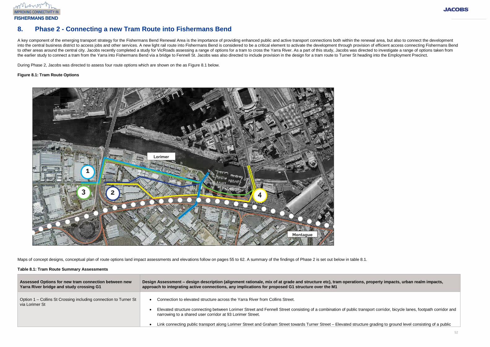
During Phase 2, Jacobs was directed to assess four route options which are shown on the as Figure 8.1 below.
Figure 8.1: Tram Route Options
Maps of concept designs, conceptual plan of route options land impact assessments and elevations follow on pages 55 to 62. A summary of the findings of Phase 2 is set out below in table 8.1.
Table 8.1: Tram Route Summary Assessments
Assessed Options for new tram connection between new
Yarra River bridge and study crossing G1
Design Assessment – design description (alignment rationale, mix of at grade and structure etc), tram operations, property impacts, urban realm impacts,
approach to integrating active connections, any implications for proposed G1 structure over the M1
Option 1 – Collins St Crossing including connection to Turner St
via Lorimer St
Connection to elevated structure across the Yarra River from Collins Street.
Elevated structure connecting between Lorimer Street and Fennell Street consisting of a combination of public transport corridor, bicycle lanes, footpath corridor and
narrowing to a shared user corridor at 93 Lorimer Street.
Link connecting public transport along Lorimer Street and Graham Street towards Turner Street – Elevated structure grading to ground level consisting of a public

53
transport corridor and shared user corridor.
Public transport link at ground level travelling west along Lorimer Street, turning south into Graham Street and then turning west into Turner Street.
Provisions for an elevated public transport stop before routes diverge.
Over shadow amenities on towers and green open space at the river side around Lorimer St Crossing.
This option is traveling along Lorimer Street. Route provides enhanced access to public tr
This option considered the impact to traffic capacity, truck route and on-street car parking to accommodate at-grade option.
In summary, option includes lowest property impact of four assessed options, however, would impact the urban realm in the area around Lorimer St.
Option 2 – Collins St Crossing including connection to Turner St
via new alignment directly towards Turner St
Connection to elevated structure across the Yarra River from Collins Street.
Extension of Turner Street to the east that provides opportunities to develop elevated plains and their amenities.
Provisions for an elevated public transport stop before routes diverge.
Significant property impacts between Lorimer Street and Ingles Street.
Over shadow amenities on towers and green open space at the river side.
This Route provide opportunity to reshape the precinct and urban realm around a central public transport and open space corridor.
In summary, significant impact on existing property boundaries that could be costly and complex to deliver. Operationally, Option 2 is the best alignment in terms of
service catchment area compared to Option 1.
Option 3 – Charles Grimes Bridge including a connection to
Turner St via Lorimer St
Connection to elevated structure across the Yarra River from Charles Grimes Bridge along Lorimer Street.
Elevated structure connecting between Lorimer Street and Fennell Street consisting of a combination of public transport corridor, bicycle lanes, footpath corridor and
narrowing to a shared user corridor at 93 Lorimer Street.
Through link connecting public transport along Lorimer Street – Elevated structure grading to ground level, public transport corridor. Whilst option provides public
transport access to the precinct, the catchment area provided by Option 3 is relatively one sided at the north of the precinct.
Route allows for no impact on future plans for open space areas
Public transport link at ground level travelling west along Lorimer Street, turning south into Graham Street and then turning west into Turner Street.
Provisions for an elevated public transport stop before the routes are diverge.
Over shadow amenities on towers and green open space along Lorimer St.
This option considered the impact to traffic capacity, truck route and on-street car parking to accommodate at-grade option.
Exempt
Exempt
Exempt

54
In summary, similar low impact on existing property boundaries as Option 1. However, would impact the urban realm along Lorimer St due to overshadowing and
impact caused by structures running along Lorimer St to the point it turns towards Fennell St. Also provides the least preferred public transport service catchment of
the four designed options.
Option 4 – Chares Grimes Bridge including a connection to
Turner St via route parallel to the M1 freeway
Connection to elevated structure across the Yarra River from Charles Grimes Bridge parallel to the northern side of the M1 Freeway.
Elevated structure crossing the M1 Freeway connecting to Fennell Street consisting of a combination of public transport corridor and shared user corridor and
widening to bicycle lanes and footpath corridor. Whilst this option provides public transport access to the precinct, the catchment area provided by Option 3 is
relatively one sided at the south of the precinct along the freeway – however, is a better catchment than Option 3 as it does move into the centre of the area earlier at Ingle St compare to Option 3 which continues on the boundary of the area up to Graham st to the west.
Through link connecting public transport and shared user corridor parallel to the northern side of the M1 Freeway joining to Ingles Street – Elevated structure grading
to ground level at the intersection of Ingles Street and Turner Street.
Public transport link at ground level travelling west along Turner Street.
Provisions for an elevated public transport stop before routes diverge.
Significant property impacts between Lorimer Street and Ingles Street along the northern side of the M1 Freeway.
The type of proposed structure G1 over M1 would need to be revised from a Cable Stayed Bridge to a Steel through Arch Structure given the reduced run up to the
crossing.
Option likely to Increase cost to some other planned new structures, in particular including Ingles St Bridge.
This route would have a relatively one-sided public transport catchment due to proximity to the M1, reducing the level of people who can access the route within a
short distance.
Reduced ability to reshape built form and land use along this route
In Summary, large impact on existing property boundaries, however, given this land is largely along the freeway side of these properties; some of the impacted land
could likely be retained to continue existing uses. Key advantage of this option is that the impact of the structure crossing Lorimer St is largely within the existing
intersection with Montague Street where urban realm values are already generally low. This may be preferred to a raised structure crossing Lorimer St to the west.

55
Exempt

56
Exempt

57
Exempt

58
Exempt

59
Exempt

60
Exempt

61
Exempt

62
Exempt

63
Exempt

64
Exempt

65
Exempt

66
Exempt

67
Interaction of Freight Corridor Option 3C with new proposed M1 crossings at Thackray Road, Salmon St and Rocklea Drive was been assessed and an increase in the height of the frieight structure proposed to ensure adequate clearances
above each new crossing . This increased height requirement would have a cost implication for deliveyr of the prposed freight corridor. To allow adequate clearances an increase in the height of freight strucutre is proposed as follows:
At Thackray Road proposed increase in the height of the freight corridor from 4.4 metres to 7.7metres
At Salmon St proposed increase in the height of the freight corridor from 6.8 metres to 8.2 metres
At Rocklea Drive proposed increase in the height of the freight corridor from 3.2 metres to 5 metres

68
Cross Section of Salmon St Land bridge looking south at freight corridor crossing point


