Download - Conveyance Ditches - SCDHEC

526 South Church Street
Mail Code EC13K
Charlotte, NC 28202
o: 980.373.2663
c: 704.497.3627
f: 000.000.0000
Aug. 27, 2020 Mr. Greg Cassidy South Carolina Department of Health and Environmental Control 2600 Bull Street Columbia, SC 29201 Subject: Remedial Investigation Work Plan Addendum – Former Storm Water
Conveyance Ditches Former Bramlette Manufactured Gas Plant 400 East Bramlette Road, Greenville SC VCC 16-5857-RP Dear Mr. Cassidy: Please find enclosed the referenced work plan for additional remedial investigation activities associated with the former storm water conveyance ditches. Pending receipt of wetland permits and access agreements, the work is planned to take place in October/November of this year. If you have any questions, please contact me at (980) 373-2663 or at [email protected].
Sincerely,
Richard E. Powell, P.G. Lead Environmental Specialist cc: Kevin Boland, CSXT
Daniel Schmitt, Esq., CSXT

Todd D. Plating, SC PG2620
Senior Project Manager
Brian McGann
Senior Scientist
REMEDIAL INVESTIGATION WORK PLAN
ADDENDUM – FORMER STORM WATER
CONVEYANCE DITCHES
FORMER BRAMLETTE MGP SITE 400 EAST BRAMLETTE ROAD
GREENVILLE, SOUTH CAROLINA
VCC 16-5857-RP
AUGUST 2020
PREPARED FOR
DUKE ENERGY CAROLINAS, LLC

Remedial Investigation Work Plan Addendum – Former Storm Water Conveyance Ditches August 2020
Duke Energy Carolinas, LLC - Former Bramlette MGP Site SynTerra
Page i
TABLE OF CONTENTS
SECTION PAGE
1.0 INTRODUCTION ......................................................................................................... 1-1
1.1 Objectives ................................................................................................................... 1-1
1.2 Site Setting and Description .................................................................................... 1-2
1.3 Former Storm Water Conveyance Description ..................................................... 1-2
2.0 PROPOSED ASSESSMENT METHODS ................................................................. 2-1
2.1 Pre-Construction Wetland Evaluation and Permitting ....................................... 2-1
2.2 Sampling Methodology ............................................................................................ 2-1
2.3 Sediment Sampling ................................................................................................... 2-2
2.4 Sediment Analysis .................................................................................................... 2-3
2.5 Sediment Toxicity ..................................................................................................... 2-4
2.6 Toxicity Sampling Methodology ............................................................................ 2-5
2.7 Toxicity Analysis ....................................................................................................... 2-5
2.8 IDW Management ..................................................................................................... 2-6
3.0 SCHEDULE AND REPORTING ................................................................................ 3-1
4.0 REFERENCES ................................................................................................................ 4-1
LIST OF FIGURES
Figure 1-1 USGS Topographic Map
Figure 1-2 Ditch Assessment Plan
Figure 1-3 1943 Aerial Photograph

Remedial Investigation Work Plan Addendum – Former Storm Water Conveyance Ditches August 2020
Duke Energy Carolinas, LLC - Former Bramlette MGP Site SynTerra
Page ii
LIST OF ACRONYMS
bls below land surface
CSXT CSXT Transportation, Inc.
CSM Conceptual Site Model
DPT direct push technology
Duke Energy Duke Energy Carolinas, LLC
IDW investigation derived waste
MGP manufactured gas plant
NAPL non-aqueous phase liquid
PIANO paraffins, isoparaffin, aromatics, naphthenes, and olefins
PAH polycyclic aromatic hydrocarbons
PID photoionization
QAPP quality assurance project plan
RI remedial investigation
RIWP Remedial Investigation Work Plan
RIWP-A Remedial Investigation Work Plan Addendum
SCDHEC South Carolina Department of Health and Environmental Control
SESD Science and Ecosystem Support Division
Site Five parcels [Parcel 1 location of former MGP), Parcel 2, Parcel 3,
Parcel 4, and Parcel 5] owned by CSXT Transportation, Inc.
SOP standard operating procedure
VOC semi-volatile organic compounds
USEPA U.S. Environmental Protection Agency
VCC Voluntary Cleanup Contract
VOC volatile organic compounds

Remedial Investigation Work Plan Addendum – Former Storm Water Conveyance Ditches August 2020
Duke Energy Carolinas, LLC - Former Bramlette MGP Site SynTerra
Page 1-1
1.0 INTRODUCTION
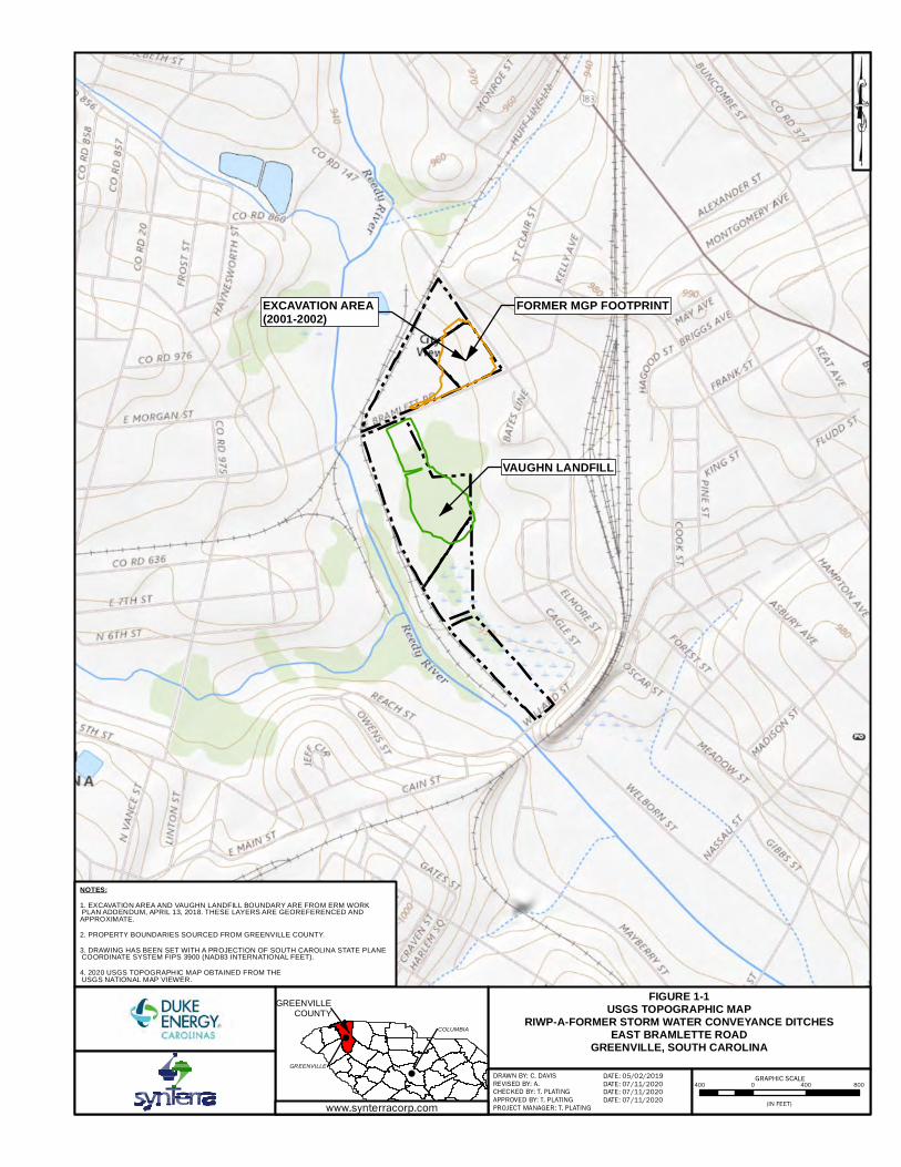
Duke Energy Carolinas LLC (Duke Energy) is conducting a remedial investigation (RI)
at the site of the former Bramlette manufactured gas plant (MGP) (400 East Bramlette
Road, Greenville, South Carolina) (Figure 1-1). The RI is being conducted under a
Responsible Party Voluntary Cleanup Contract (VCC 16-5857-RP) with the South
Carolina Department of Health and Environmental Control (SCDHEC) dated July 29,
2016. RI activities to delineate the source, nature, and extent of affected environmental
media resulting from past operation of the MGP began in 2017. Results of the
investigation through April 2020 were summarized in the RI Report, which was
submitted to the SCDHEC on June 26, 2020.
The RI Report indicated additional data is needed to determine the extent of impacts
remaining in sediment and soil associated with historical drainage ditches present
during the time of MGP operations. Several constituents also were identified with
maximum concentrations greater than ecological screening criteria. This RI Work Plan
Addendum (RIWP-A) for the Former Storm Water Conveyance Ditches proposes
activities to complete assessment of MGP-related constituents in the historical ditches.
1.1 Objectives
Based on a review of historical aerial photography, a network of ditches was present on
the Site during the time of MGP operations. The ditches appear to have been associated
with plant operations. Observed non-aqueous phase liquid (NAPL) consistent with the
location of these ditches indicates a likely migration pathway for overland flow
resulting from MGP operations.
This RIWP-A for the Former Storm Water Conveyance Ditches describes activities and
procedures to collect additional data and achieve the following objectives:
Define the horizontal and vertical extent of NAPL in sediment and underlying
soil within historical Site ditches.
Determine the concentration and distribution volatile organic compounds
(VOCs) and semivolatile organic compounds (SVOCs) present within sediments
in historical Site ditches.
Conduct testing to determine probable risk from exposure to polycyclic aromatic
hydrocarbons (PAH)s for ecological receptors within the historical ditch on
Parcels 3, 4, and 5.

Remedial Investigation Work Plan Addendum – Former Storm Water Conveyance Ditches August 2020
Duke Energy Carolinas, LLC - Former Bramlette MGP Site SynTerra
Page 1-2
1.2 Site Setting and Description
The Site is comprised of five parcels that cover approximately 30 acres. The Site is
bounded by the CSX Transportation, Inc. (CSXT) railroad corridor to the north, west,
and south, and by West Washington Street, the Legacy Charter Elementary School
(Legacy Elementary), and the City of Greenville Sanitation Department to the east. The
Reedy River and Swamp Rabbit Trail define the western boundary of the Site. The
following table summarizes each parcel.
Tax Map Serial
Number
Parcel ID (Zoning
Classification) Land Use
0140000300300 Parcel 1 (I-1) Vacant lot and location of former MGP operations
0140000300200 Parcel 2 (I-1) Active rail operations and location of a former asphalt
manufacturing plant (operational in 2003, www.gcgis.org
aerial photograph) and debris pile
0138000100100 Parcel 3 (I-1) Active rail operations and location of CSX field office,
unpermitted Vaughn Landfill, and numerous sewer lines and
access manways
0054000300100 Parcel 4 (R-6) Jurisdictional wetland, and therefore, not suitable for
development; vacant lot
0054000600100 Parcel 5 (S-1) Jurisdictional wetland; vacant lot
A detailed summary of Site background information including setting and description,
MGP operational history, receptors, and previous assessment activities is presented in
the RI Report.
1.3 Former Storm Water Conveyance Description
Historical aerial imagery was reviewed to determine the presence of historical storm
water conveyance ditches during MGP operations (Appendix B, RI Report). The
network of historical ditches was present in 1943 (the earliest imagery available) and are
shown on Figure 1-2. The 1943 image shows that runoff from the MGP Parcel (Parcel 1)
was connected to the primary ditch that transects Parcels 2 through 5 by pipelines and
trenches (Figure 1-3). Except for Ditch 1 (Figure 1-2) historical drainage patterns remain
unchanged from their original configuration.
The configuration of the historical ditch network, and observation of NAPL consistent
with the location of the ditches, indicate that the ditches were a likely migration
pathway for process water and coal tar residuals. The conceptual site model (CSM)
presented in Section 8.2 of the RI Report concludes that NAPL accumulated in the
ditches and low energy zones, such as the wetlands, and migrated vertically through

Remedial Investigation Work Plan Addendum – Former Storm Water Conveyance Ditches August 2020
Duke Energy Carolinas, LLC - Former Bramlette MGP Site SynTerra
Page 1-3
the unsaturated zone to the water table. Once enough accumulated, NAPL continued to
migrate vertically through the water column until a less permeable matrix was
encountered (saprolite and bedrock).
Five ditch segments have been identified for additional assessment and are described
below:
Ditch 1 originates on Parcel 1 near the coal pile for the MGP. The ditch flowed to
the west and then south a distance of approximately 984 feet. The ditch
discharged to a larger ditch flowing southeast at Bramlette Road. This ditch is no
longer apparent and does not convey surface water flow.
Ditch 2 is located on Parcel 1 and Parcel 2 and originates at a culvert from West
Washington Street. The ditch flows approximately 763 feet through Parcel 1 to
the southwest and parallels Bramlette Road before entering a culvert that
conveys flow to the southeast toward Parcel 3. This ditch conveys wet weather
storm water flow.
Ditch 3 is associated with the wetlands area between the Vaughn Landfill and
Legacy Charter Elementary School. The northern portion of Ditch 3 was
previously assessed. Surface water flow from the wetlands enters a culvert and
flows southwest through an incised ditch that bisects the Vaugh Landfill. The
approximate length of ditch planned for assessment is 139 feet. The southern
portion of the wetlands is routinely inundated. Depth of water present can range
from approximately 1 foot to 3 feet.
Ditch 4 transects Parcel 3, Parcel 4, and Parcel 5. The portion of Ditch 4 planned
for assessment begins at the south end of the Vaughn Landfill and flows
approximately 1,637 feet prior to discharging into the Reedy River. This ditch
conveys storm water drainage and during dry periods continues to flow with
drainage from wetlands areas on Parcel 3.
Ditch 5 conveys storm water flow from West Washington Street along Willard
Street. The ditch segment to be assessed begins at Cagle Street and flows
southwest 469 feet where it discharges to Ditch 4 described above. This ditch
conveys wet weather storm water flow.

Remedial Investigation Work Plan Addendum – Former Storm Water Conveyance Ditches August 2020
Duke Energy Carolinas, LLC - Former Bramlette MGP Site SynTerra
Page 2-1
2.0 PROPOSED ASSESSMENT METHODS
Investigation procedures, document management, sample nomenclature, and data
quality will be conducted in accordance with the Quality Assurance Project Plan
(QAPP, SynTerra 2018). Proposed assessment activities (in order of implementation) are
depicted on Figure 1-2 and include:
Parcel 1 and Parcel 2 soil borings
Parcel 3, Parcel 4, and Parcel 5 soil borings
Willard Street soil borings
2.1 Pre-Construction Wetland Evaluation
and Permitting
Proposed assessment activities in Parcels 3, 4 and 5 and Willard Street include work in a
federally classified wetland. Nationwide Permit 38 has been determined to be the
appropriate permit for work within wetlands at the Bramlette Road MGP. Proposed
ditch assessment activities that are planned within a jurisdictional wetland will be
implemented after receiving permit approval.
2.2 Sampling Methodology
An objective of this assessment, and the overall RI, is to determine the presence and
delineate the extent of NAPL, if encountered. As such, additional soil borings along the
centerline of historical drainage ditches at Parcels 1, 2, 3, 4, and 5 are proposed (Figure
1-2). Soil borings will be spaced approximately 100 feet apart and advanced using direct
push technology (DPT) drilling methods. Where proposed borings are submerged, a
temporary PVC surface casing may be used to maintain borehole integrity during
drilling and abandonment.
Borings will be advanced from land surface to a minimum of 2 feet into the underlying
saprolite. The sediment/soil cores will be visually inspected and logged for lithology
and presence/absence of NAPL from MGP operations. Field screening will include
headspace measurements using a photoionization detector (PID) in accordance with
procedures described in Section 3.2 of the QAPP. Field screening results will be used to
select portions of core to be retained for laboratory analysis, as described in Section 3.2
below. Additional delineation borings may be necessary to define the lateral extent of
visually observed NAPL, if encountered. Existing ditch edges, as identified by the
ordinary high water mark, will be targeted in the direction perpendicular to surface
water flow. Where historical ditches are no longer evident additional delineation
borings will be a located a minimum of 10 feet from the primary boring in the direction

Remedial Investigation Work Plan Addendum – Former Storm Water Conveyance Ditches August 2020
Duke Energy Carolinas, LLC - Former Bramlette MGP Site SynTerra
Page 2-2
perpendicular to historical surface water flow. Additional delineation borings in the
upstream and downstream direction of existing and historical ditches will be located a
minimum of 10 feet from the primary boring.
Borings will be abandoned upon completion to terminal depth in accordance with
SCDHEC well installation standards, R. 61-71. Boring locations are shown on Figure 1-
2. A summary of proposed assessment activities is provided in the table below.
Ditch ID Proposed Assessment Activity
Ditch 1 11 borings – DA1-SB-01 through DA1-SB-11
Depth - 22 feet below land surface (bls) to 35 feet bls (2 feet into saprolite)
Samples – 11 (additional samples may be collected based on field observations).
Ditch 2 9 borings – DA2-SB-11 through DA2-SB-20
22 feet bls (2 feet into saprolite)
Samples – 9 (additional samples may be collected based on field observations).
Ditch 3 3 borings – DA3-SB-21 through DA3-SB-23
17 feet bls (2 feet into saprolite)
Samples – 3 (additional samples may be collected based on field observations).
Ditch 4 15 borings – DA4-SB-24 through DA4-SB-38
12 feet bls (2 feet into saprolite)
Samples – 15 (additional samples may be collected based on field observations).
Ditch 5 7 borings – DA5-SB-39 through DA5-SB-45
12 feet bls (2 feet into saprolite)
Samples – 7 (additional samples may be collected based on field observations).
2.3 Sediment Sampling
Cores will be collected using direct push technology. After collection, the core intervals
containing sediment will be maintained in an upright position to the extent practicable.
Any superficial water collected during the coring will be drained from the sampling
device (e.g., if using a hard liner, by drilling a small hole a few inches above the
sediment surface and allowing the water to drain). The core will be sub-sectioned using
a handheld saw or similar device. Care will be taken to prevent material from flowing
out of the hard liner during sectioning. Core sections will be emptied into stainless-steel
bowls for homogenization.

Remedial Investigation Work Plan Addendum – Former Storm Water Conveyance Ditches August 2020
Duke Energy Carolinas, LLC - Former Bramlette MGP Site SynTerra
Page 2-3
Sediment samples will be collected from soil boring cores to assess current sediment
quality beneath the historical drainage ditches. Samples will be collected in general
accordance with U.S. Environmental Protection Agency (USEPA) Science and
Ecosystem Support Division (SESD) Operating Procedure SESDPROC-200-R3
(August 21, 2014) and SynTerra’s sediment sampling standard operating procedures
(SOPs) employed by SynTerra (QAPP Appendix B, SynTerra 2018). Field screening
results will be used to select the sample interval from each boring that represents the
greatest potential COI concentrations.
Any foreign materials present (e.g., gravel, vegetation) in the sediment will be removed
when filling sample bottles. The sediment samples will be placed in ice-filled coolers
and managed under chain-of-custody protocols for submittal to the appropriate
laboratory
2.4 Sediment Analysis
All sediment samples collected will be analyzed for VOCs and SVOCs. Based on visual
observations, field screening results, and boring location, select samples may be
analyzed for additional constituents including Paraffins, isoparaffin, aromatics,
naphthenes, and olefins (PIANO), alkylated PAHs, and saturated hydrocarbons
Analyses and laboratory analytical methods are su2-2_mmarized in the table below.
Analysis Laboratory Analytical Method
VOCs USEPA Method 8260
SVOCs USEPA Method 8270 (low level benzo(a)pyrene)
PIANO USEPA Method 8260B/5035 High-Resolution sampling and analysis
Alkylated PAHs USEPA Method 8270D-SIM
Saturated hydrocarbons USEPA Method 8015D-modified

Remedial Investigation Work Plan Addendum – Former Storm Water Conveyance Ditches August 2020
Duke Energy Carolinas, LLC - Former Bramlette MGP Site SynTerra
Page 2-4
2.5 Sediment Toxicity
Several PAHs in sediment were identified at concentrations greater than ecological
screening values in the RI Report. Sediment toxicity testing is proposed to further
evaluate PAH concentrations in sediment and determine whether a probable risk of
adverse effects to ecological receptors exists within historical ditches on Parcels 3, 4, and
5. The results of the risk determination will be considered in the development of
potential remedial strategies considered in a feasibility study. The proposed toxicity
assessment approach is consistent with the tiered system to determine the risk of
adverse effects due to PAHs in sediments presented in Figure 1.3 from USEPA (2009),
which is provided below as a general guidance for toxicity testing for ecological risk
assessment.
Conceptual Model for Applying Various Sediment Assessment Approaches in a Tiered System to
Determine the Risk of Adverse Effects Due to PAHs in Sediments (USEPA 2009).

Remedial Investigation Work Plan Addendum – Former Storm Water Conveyance Ditches August 2020
Duke Energy Carolinas, LLC - Former Bramlette MGP Site SynTerra
Page 2-5
Sample locations for sediment toxicity testing within Parcels 3, 4, and 5 will be
determined in the field. Proposed sample quantities are summarized in the table below.
Parcel Number Sediment Toxicity Sample Quantity
3 2
4 3
5 3
Willard Street (reference location) 1
2.6 Toxicity Sampling Methodology
Samples collected for toxicity analysis will be collected directly from the ditch adjacent
to soil and sediment boring locations. Sample collection for Tier 1 and Tier 3 assessment
includes collection of bulk sediment samples representing the upper 2-3 centimeters
(cm) of surface sediments. Approximately 1-gallon of sediment from each location will
be collected using a stainless steel spoon or scoop consistent with procedures described
in SESDPROC-200-R3 and SynTerra SOPs (QAPP Appendix B, SynTerra 2018).
Sediment pore water collection for Tier 2 assessment will be performed in accordance
with procedures described in SESDPROC-513-R2. Samples will be collected using a
pore water extracting device such as a PushPoint ™ sampler. The sampling end of the
pore water device is inserted into the sediment to the desired depth, and pore water is
extracted using a syringe or peristaltic pump. Other similar devices may be used
providing that the integrity of the sample is maintained and no ambient surface water is
allowed to mix with the sample.
2.7 Toxicity Analysis
Each toxicity assessment sample will be analyzed for the parameters summarized in the
table below.
Tier Analysis Laboratory Analytical Method
1 and 2 SVOCs USEPA Method 8270C
1 Total organic carbon USEPA Method 9060
1 Black carbon Gustafsson method (Gustafsson 1997)
3 Toxicity - amphipod
Hyalella Azteca
28-day exposure, USEPA Method 100.4

Remedial Investigation Work Plan Addendum – Former Storm Water Conveyance Ditches August 2020
Duke Energy Carolinas, LLC - Former Bramlette MGP Site SynTerra
Page 2-6
2.8 IDW Management
Solid and liquid investigation derived waste (IDW) will be generated during collection
of soil cores and environmental media sampling. Solids and liquids will be contained,
as appropriate, in 55-gallon barrels or lined roll-off containers, and will be transported
to an approved disposal facility in a timely manner. IDW containing NAPL will be
segregated. Reusable equipment will be decontaminated using Liquinox (or similar)
and water between sampling locations. Decontamination fluids will be collected and
disposed of with IDW.

Remedial Investigation Work Plan Addendum – Former Storm Water Conveyance Ditches August 2020
Duke Energy Carolinas, LLC - Former Bramlette MGP Site SynTerra
Page 3-1
3.0 SCHEDULE AND REPORTING
After completion of the assessment activities, an RI Report Addendum will be
prepared. The report will summarize the compiled results of the assessment conducted
under the VCC. The report will include the following:
Description of assessment activities
Results of the sample analysis
Laboratory data sheets
Data tables summarizing results of the assessment
Figures illustrating assessment activities and results of the sampling activities
The following preliminary schedule is proposed. The schedule is dependent on
approval of the RIWP-A for the Former Storm Water Conveyance Ditches by the
SCDHEC and obtaining the necessary permits and property access agreements. Upon
approval, an updated project schedule will be developed.
Task Date
Remedial Investigation Work Plan Addendum – Former Storm Water
Conveyance Ditches submittal to SCDHEC August 2020
SCDHEC approval of 2020 work plan September 2020
Execute access agreements (approximately 45 days from submittal of
amended access agreement)
October 2020
Initiate 2020 assessment October 2020
Complete 2020 assessment November 2020
Submit Report First Quarter 2021

Remedial Investigation Work Plan Addendum – Former Storm Water Conveyance Ditches August 2020
Duke Energy Carolinas, LLC - Former Bramlette MGP Site SynTerra
Page 4-1
4.0 REFERENCES
Applied Engineering & Science, Inc. 1996. “Site Investigation Phase II: Vaughn
Landfill/Duke Power Sites.”
Duke Energy Site Remediation Services Group. 2003. “Remedial Action Plan Final
Report: CSXT/Vaughn Landfill and Bramlette Road MGP Sites.”
Gustafsson, Chan. MacFarlane and Gschwend. 1997. Quantification of the Dilute
Sedimentary Soot Phase: Implications for PAH Speciation and Bioavailability.
Environmental Science and Technology, 1997, Vol 31, pgs 203-209.
South Carolina Department of Health and Environmental Control. 2016. “Regulation
61-71 Well Standards.”
South Carolina Department of Health and Environmental Control. 2016. “Voluntary
Cleanup Contract in the Matter of CSXTF Bramlette Road Site, Greenville County
and Duke Energy Carolinas, LLC.”
SynTerra Corporation. 2018. “Quality Assurance Project Plan (QAPP): Former Bramlette
MGP Site.”
SynTerra Corporation. 2020. “Remedial Investigation Report (RI Report): Former
Bramlette MGP Site.”
US EPA. 2009. “Evaluating Ecological Risk to Invertebrate Receptors from PAHs in
Sediments at Hazardous Waste Sites.”
US EPA. 2013. “Science and Ecosystem Support Division (SESD) Operating Procedure
SESDPROC-513-R2.”
US EPA. 2014. “Science and Ecosystem Support Division (SESD) Operating Procedure
SESDPROC-200-R3.”

Remedial Investigation Work Plan Addendum – Former Storm Water Conveyance Ditches August 2020
Duke Energy Carolinas, LLC - Former Bramlette MGP Site SynTerra
FIGURES
USGS The National Map: National Boundaries Dataset, 3DEP Elevation
Program, Geographic Names Information System, National HydrographyDataset, National Land Cover Database, National Structures Dataset, andNational Transportation Dataset; USGS Global Ecosystems; U.S. Census
Bureau TIGER/Line data; USFS Road Data; Natural Earth Data; U.S.Department of State Humanitarian Information Unit; and NOAA NationalCenters for Environmental Information, U.S. Coastal Relief Model. Data
refreshed December, 2019.
FIGURE 1-1USGS TOPOGRAPHIC MAP
RIWP-A-FORMER STORM WATER CONVEYANCE DITCHESEAST BRAMLETTE ROAD
GREENVILLE, SOUTH CAROLINA
NOTES:1. EXCAVATION AREA AND VAUGHN LANDFILL BOUNDARY ARE FROM ERM WORK PLAN ADDENDUM, APRIL 13, 2018. THESE LAYERS ARE GEOREFERENCED AND APPROXIMATE.
2. PROPERTY BOUNDARIES SOURCED FROM GREENVILLE COUNTY.
3. DRAWING HAS BEEN SET WITH A PROJECTION OF SOUTH CAROLINA STATE PLANE COORDINATE SYSTEM FIPS 3900 (NAD83 INTERNATIONAL FEET).
4. 2020 USGS TOPOGRAPHIC MAP OBTAINED FROM THE USGS NATIONAL MAP VIEWER.
400 0 400 800 GRAPHIC SCALE!
!
DATE: 07/11/2020
GREENVILLECOUNTY
GREENVILLE
COLUMBIA
DRAWN BY: C. DAVISCHECKED BY: T. PLATINGREVISED BY: A.
(IN FEET)APPROVED BY: T. PLATINGPROJECT MANAGER: T. PLATING
DATE: 05/02/2019DATE: 07/11/2020 DATE: 07/11/2020 www.synterracorp.com
VAUGHN LANDFILL
FORMER MGP FOOTPRINTEXCAVATION AREA (2001-2002)

")
")
")
")
")
")
")
")
")
")
")
")
")
")
")
")
")
")
")
")
")
")
")
")
")")
")
")
")
")
")
")
")
")
")
")
")
")
")
")
")
")
")
")
")
DITCH 1DITCH 2
DITCH 3
DITCH 4
DITCH 5
REEDY RIVER
PARCEL 5
PARCEL 4
VAUGHNLANDFILL
PARCEL 3
PARCEL 1
EXCAVATIONAREA (2001-2002)
PARCEL 2
960
930
920
920
920
950
980
960
930
960
930
930
980
950
980
970
93096
093
0
970
930
940
930
940
940
950
960
940
930
950
950
930
FIGURE 1-2DITCH ASSESSMENT PLAN
RIWP-A-FORMER STORM WATERCONVEYANCE DITCHES
FORMER BRAMLETTE ROAD MGP SITEEAST BRAMLETTE ROAD
GREENVILLE, SOUTH CAROLINA
125 0 125 250GRAPHIC SCALE
DRAWN BY: C. DAVIS
CHECKED BY: T. PLATING
REVISED BY: C. WYATT DATE: 08/12/2020
(IN FEET)
DATE: 08/12/2020
APPROVED BY: T. PLATING
PROJECT MANAGER: T. PLATING
DATE: 08/12/2020
DATE: 04/20/2020
www.synterracorp.com
NOTES:
1. ELEVATIONS ARE REFERENCED TO THE NORTH AMERICAN VERTICAL DATUM88 (NAVD 88).
2. FORMER DRAINAGE DITCHES, EXCAVATION AREA, AND VAUGHN LANDFILLBOUNDARY FROM ERM GROUNDWATER REMEDIAL INVESTIGATION WORKPLAN ADDENDUM, APRIL 13, 2018. THESE LAYERS ARE GEOREFERENCED ANDAPPROXIMATE.
3. TOPOGRAPHIC CONTOURS FOR GREENVILLE COUNTY FROM SC DNR (2013).
4. PROPERTY BOUNDARIES SOURCED FROM GREENVILLE COUNTY.
5. WETLANDS BY US FISH AND WILDLIFE NATIONAL WETLAND INVENTORY.
6. SWAMP RABBIT TRAIL CENTERLINE FROM CITY OF GREENVILLE.
7. AERIAL PHOTOGRAPHY OBTAINED FROM GOOGLE EARTH PRO ON MAY 3,2019. AERIAL WAS COLLECTED ON MARCH 12, 2018.
8. DRAWING HAS BEEN SET WITH A PROJECTION OF SOUTH CAROLINA STATEPLANE COORDINATE SYSTEM FIPS 3900 (NAD83 INTERNATIONAL FEET).
TABLE NOTES:
1. -- - NOT APPLICABLE
2. ° - DEGREES
3. FT - FEET
4. SQ FT - SQUARE FEET
LEGEND
") PROPOSED SOIL BORING LOCATION
PROPOSED DITCH ASSESSMENT DITCH
FORMER DRAINAGE DITCH (1964)
CLEARING BY DUKE ENERGY (10')
VAUGHN LANDFILL BOUNDARY
EXCAVATED AREA (2001-2002)
WETLANDS (AES)
WETLANDS (USFWS)
FORMER MGP STRUCTURAL OPERATIONS
BUILDING
PARCEL BOUNDARY
TOPOGRAPHIC CONTOUR (10' INTERVAL)
TOPOGRAPHIC CONTOUR (2' INTERVAL)
! ! SWAMP RABBIT TRAIL
ROAD
RAILROAD
Length:Clearing Area: Soil Boring ID Latitude Longitude Clearing AreaDA1-SB-01 34.8627228° -82.4182731° --DA1-SB-02 34.8626741° -82.4186011° --DA1-SB-03 34.8626200° -82.4189276° --DA1-SB-04 34.8624809° -82.4192124° --DA1-SB-05 34.8622584° -82.4194027° --DA1-SB-06 34.8620045° -82.4195298° --DA1-SB-07 34.8617449° -82.4196387° --DA1-SB-08 34.8614884° -82.4197578° --DA1-SB-09 34.8612467° -82.4199155° --DA1-SB-10 34.8610293° -82.4201184° --DA1-SB-11 34.8608339° -82.4202691° --
Length:Clearing Area: Soil Boring ID Latitude Longitude Clearing AreaDA2-SB-12 34.8629196° -82.4180648° --DA2-SB-13 34.8627149° -82.4182636° --DA2-SB-14 34.8624990° -82.4184421° --DA2-SB-15 34.8622536° -82.4185501° --DA2-SB-16 34.8619977° -82.4186185° --DA2-SB-17 34.8617405° -82.4186802° --DA2-SB-18 34.8614871° -82.4187574° --DA2-SB-19 34.8613519° -82.4190238° --DA2-SB-20 34.8612252° -82.4193023° --
Length:Clearing Area: Soil Boring ID Latitude Longitude Clearing AreaDA3-SB-21 34.8604555° -82.4190050° --DA3-SB-22 34.8602358° -82.4190108° --DA3-SB-23 34.8600735° -82.4190150° --
Length:Clearing Area: Soil Boring ID Latitude Longitude Clearing AreaDA4-SB-24 34.8585353° -82.4188243° --DA4-SB-25 34.8582456° -82.4186557° --DA4-SB-26 34.8579559° -82.4184872° --DA4-SB-27 34.8576658° -82.4183198° --DA4-SB-28 34.8573729° -82.4181596° --DA4-SB-29 34.8570803° -82.4179987° --DA4-SB-30 34.8568156° -82.4177804° --DA4-SB-31 34.8565584° -82.4175468° --DA4-SB-32 34.8563012° -82.4173132° --DA4-SB-33 34.8560450° -82.4170780° --DA4-SB-34 34.8557906° -82.4168399° --DA4-SB-35 34.8555362° -82.4166018° --DA4-SB-36 34.8552790° -82.4163688° --DA4-SB-37 34.8549794° -82.4163066° --DA4-SB-38 34.8547008° -82.4164959° --
Length:Clearing Area: Soil Boring ID Latitude Longitude Clearing AreaDA5-SB-39 34.8559655° -82.4148852° 210 sq ft DA5-SB-40 34.8558193° -82.4150315° 290 sq ft DA5-SB-41 34.8556076° -82.4152439° 330 sq ft DA5-SB-42 34.8554020° -82.4154650° 330 sq ft DA5-SB-43 34.8551983° -82.4156886° 290 sq ft DA5-SB-44 34.8550503° -82.4159606° --DA5-SB-45 34.8551167° -82.4162833° --
--
139 ft
469 ft8458 sq ft or 0.194 acres
Ditch 2
Ditch 3
Ditch 4
Ditch 5
--
1637 ft5333 sq ft or 0.122 acres
Proposed Ditch Assessment Boring Locations
Ditch 1984 ft--
763 ft

www.synterracorp.com
DRAWN BY: T.PLATING DATE: 8/5/2020
REVISED BY:
CHECKED BY: M.MASTBAUM
APPROVED BY: T.PLATING
PROJECT MANAGER: T.PLATING
FIGURE 1-3
1943 AERIAL PHOTOGRAPH
RIWP-A – FORMER STORM WATER
CONVEYANCE DITCHES
FORMER BRAMLETTE ROAD MGP SITE
EAST BRAMLETTE ROAD
GREENVILLE, SOUTH CAROLINA
DITCH 1
DITCH 2
DITCH 3


