CONSULTANCY MISSION REPORT FOR
Maldives
Dr. Y.E.A. Raj, Mission Expert on Meteorology,
Mr. Abdul Majid, Mission Expert on Hydrology and
Mr. Ahmed Kamal, Mission Expert on DRR.
10 October 2014
As part of the project on Synergized Standard Operating Procedures (SSOP) for
Coastal Multi-Hazards Early Warning System, three expert consultants, one on
meteorology, one on hydrology, and one on Disaster Risk Reduction, conducted a
highly successful two-day mission to Maldives on 10–11 August 2014. The purpose
of the mission was to collection and compile data, information, examples, and
diagrams on standard operating procedures (SOPs) best practices, gaps and
needs, and recommendations for inclusion in the Manual on Synergized
Standard Operating Procedures (SSOP) for Coastal Multi-Hazard Early
Warning System which will meet the needs of the 13 beneficiary countries
involved in the Project.
1
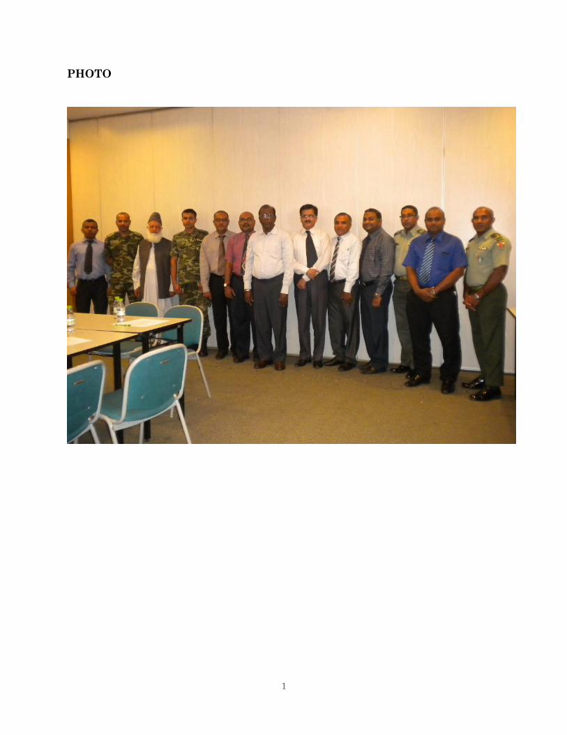
PHOTO
2
Acknowledgments
These workshops were conducted as Activity 1.3 of Project Synergized Standard
Operating Procedures (SSOP) for Coastal Multi-Hazards Early Warning System. The lead
organizations for the project are the ESCAP/WMO Typhoon Committee and the WMO/ESCAP
Panel on Tropical Cyclones in association with a wide cross section of partner agencies. Very
kind appreciation is expressed to ESCAP Trust Fund for Tsunami, Disaster and Climate
Preparedness in Indian Ocean and Southeast Asian Countries who have funded this project; to
the (Different organizations involved in the two day meetings) for their vital assistance, support,
and active participation in these successfully workshop; and Typhoon Committee Secretariat
who provided excellent and very time consuming support, coordination, detailed arrangements,
and insights for the missions.
3
Consultancy Mission Report for Maldives
Dr. Y.E.A. Raj, Mission Expert on Meteorology,
Mr. Abdul Majid, Mission Expert on Hydrology and
Mr. Ahmed Kamal, Mission Expert on DRR.
Table of Contents
1. Introduction - 4
2. Project Overview - 4
3. Purpose of the Mission Visits - 4
4. Mission Dates and Team Members - 5
5. Workshop Programme and Overview - 5
6. Mission summary / EWS
6.1 Meteorology - 7
6.2 Hydrology - 10
6.3 DRR - 11
7. Mission Summary / SOPs
7.1 Meteorology - 17
7.2 Hydrology - 19
7.3 DRR - 19
8. Conclusions - 21
9. List of Appendixes, References & Bibliography (Met) & - 22
List of Appendixes (General)
(in a separate pdf file not enclosed in this report)
10. Appendixes
Common 1-2 - 24
MET 3-11 - 37
DRR 12-14 - 53
(Total no. of pages including cover 62)
4
1. Introduction
The Economic and Social Commission of Asia and Pacific (ESCAP) approved a
submitted project Synergized Standard Operating Procedures (SSOP) for Coastal Multi-Hazards
Early Warning System (EWS) and funded it through the ESCAP Multi-Donor Trust Fund for
Tsunami, Disaster and Climate Preparedness in Indian Ocean and South East Asia.
ESCAP/World Meteorological Organization (WMO) Typhoon Committee (TC) and the
WMO/ESCAP Panel on Tropical Cyclones (PTC) in cooperation with other agencies had
recognized a strong need to create synergies in early warning systems among different types of
coastal hazards by reviewing existing Standard Operating Procedures (SOPs).
2. Project Overview
The goal of the project is to promote community resilience to coastal multi-hazards
through effective SOPs for multi-hazards EWSs. The project is collaboration with multiple
agencies and organizations. It involves thirteen beneficiary countries in TC and PTC regions.
The designated target groups include National Meteorological and Hydrological Services,
National Tsunami Warning Centres, and National Disaster Management Offices in TC and PTC
Members’ countries.
Activity 1 is to collect, review, analyze, and synergize existing SOPs in TC and PTC
Members’ countries and develop a Manual/Handbook of SSOP Procedures. The third item in
Activity 1 is to synergize existing SOPs and develop additional SOPs as needed to meet
identified gaps and needs and compile a Manual of Synergized Standard Operating Procedures
(SSOP) for Coastal Multi-Hazards Early Warning Systems (EWS), mainly focusing on the
hydro-meteorological aspect, to meet the needs of diverse users, like decision makers, early
warning issuers, media, researchers, operational, public, including fishermen at community level.
To complete Activity 1.3 and to meet the success indicator, in addition to the three in-
country pilot workshops already carried out, consultants visited targeted countries in the Panel of
Tropical Cyclone region, Myanmar, Sri Lanka and Maldives and 3 targeted countries in the
Typhoon Committee region, Cambodia, Malaysia and Viet Nam. The missions to the PTC
region countries were conducted during 4 – 11 Aug 2014 and to the TC region countries during
28 Aug – 5 Sep 2014.
3. Purposes of the Mission Visits
a. To review existing coastal multi-hazards EWS SOPs of hydro-meteorological services,
disaster management, media, roles of elected official, and others from national to district to
local levels,
b. To identify best practices, gaps and needs, and recommendations for internal and cross-
cutting SOPs, and
c. To compile data, information, examples, and diagrams collected on SOPs best practices, gaps
and needs, and recommendations for inclusion in the Manual on Synergized Standard
Operating Procedures (SSOP) for Coastal Multi-Hazard Early Warning System which will
meet the needs of the 13 beneficiary countries involved in the Project.
5
4. Missions Dates and Team Members
Dates:
a. PTC Countries
Myanmar 4 - 5 August 2014
Sri Lanka 7 - 8 August 2014
Maldives 10 -11 August 2014
b. TC Countries
Malaysia 28 - 29 August 2014
Cambodia 1 - 2 September 2014
Viet Nam 4 - 5 September 2014
Team members:
a. For the PTC countries’ missions:
Dr. Y.E.A. Raj (Dr. Yesudhas Eben Aruma Raj), Former Deputy Director General,
Regional Meteorological Centre, Chennai, India Meteorological Department
Mr. Abdul Majid, Former Director of National Flood Forecasting Bureau, Pakistan
Mr. Ahmed Kamal, Member (Disaster Risk Reduction - DRR), National Disaster
Management Authority, Prime Minister's Office, Pakistan
b. For TC countries’ missions:
Dr. Tokiyoshi Toya, Former Regional Director for Asia and the South-West Pacific,
WMO;
Mr. Abdul Majid, Former Director of National Flood Forecasting Bureau, Pakistan;
Mr. Amir Ali Khan, Assistant Professor, National Institute for Disaster Management,
New Delhi, India.
5. Workshop Programme Overview
The programme for the two-day workshop for all the three countries as designed by the
project manager and the SSOP committee is given in Appendix 1a. Another program slightly
modified as specific to Maldives and was made available to the consultants is given in Appendix
1 b.
The actual program as it took place is given below.
Day 1 10 Aug 2014, Venue: Adsaree Hall, Male
0845-0845 - Introduction by the Consultants
Mr. Abdul Majid
Mr. Ahemd Kamal
Dr. Y.E.A. Raj
0915-1030 - With participants, Brief presentation by the consultants
0845-1200 - Discussion with the participants DRR & Hydro, and
6
Met.
1315-1530 Interaction with media
1530-1630 - Discussions
Day 2 11 Aug 2014
0830-1100 - Interaction between DRR and participants associated with
Disaster management with several NGOs such as Red Crescent
Interaction between Hydro and Met consultants with MMS
personnel (parallel)
1100-1300 Combined session
1330-1500 - Summarising, briefing by the consultants and discussions on
recommendations.
Brief description of the proceeding during 10-11 August 2014 at Male is given below. List
of participants is given in Appendix 2.
The proceedings of Day 1 i.e., 10 Aug 2014, commenced at about 0845 hours. Dr. Ali
Shareef, Deputy Director General of Maldives Meteorological Services (MMS) welcomed the
consultants and the various other participants. The consultant Mr. Abdul Majid, Mr. Ahmed
Kamal and Dr. Y.E.A. Raj provided a briefing to the participants about the purpose of their visit
and the scope of the mission. A short briefing was provided by the personnel from MMS from
their end. A combined session was held during the pre-lunch period. Elaborate briefing was
provided by the participants from the fishing industry on the warning services made available to
them by the MMS. The personnel from National disaster management service gave a briefing to
the DRR consultant. The participants from Red Crescent provided a detailed briefing about the
work undertaken by them to disseminate warning messages to people and school students, in
organising drills and in imparting training in the various aspects of disaster management.
Discussions pertained to disaster management in schools, in the tourisms fields especially in
resort islands. Localised flooding and their effects were also briefed.
In the afternoon session there was extensive discussion with media. There were 5
participants hailing from Maldives broadcasting commissions and private TV channels.
However no participants from print media or radio participated. The media personnel wanted
better and visually attractive products which includes graphics and animation from the MMS and
said that expectation from public in this respect is very high. Frequent updates in the MMS
website also was demanded by the media personnel.
On 11 Aug 2014 during 0820-1030 hours the DRR consultant held discussions with
participants from the various islands. The MET and Hydro consultants had interaction with the
personnel of the MMS. 8 personnel from MMS participated and several aspects of the replies to
the questionnaire were also discussed. At 1100 hours the other consultants also joined with the
DRR consultant and continued the discussions. In the post lunch session the consultants
7
summarised the proceedings and provided a briefing about the likely recommendations. The
workshop closed at 1500 hours. Director General of MMS met the consultants on 11 Aug 2014.
6. Mission Summary / Early warning system
6.1 Meteorology/ EWS
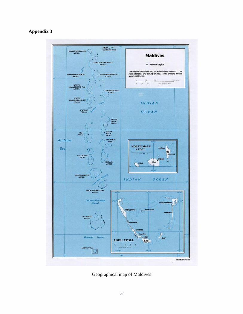
Maldives is an island nation in the Indian Ocean – Arabian Sea, consisting of 1192
islands out of which 192 are inhabitable. The total area of all the islands put together is 298
sq.km only and the total population is nearly 394,000 with Male the capital island having a
population of nearly 104,000. The average elevation of the islands is just 1.5 metres with the
highest point at 2.4m. The estimated coastal length is 664 kms. The aggregate of the numerous
islands of Maldives lie between latitudes 0.8°S to 7.1°N and longitudes 72.5°E to 73.76°E. The
northern most island is located at 7.15°N and the southernmost island at 0.75°S. The annual
normal rainfall is nearly 250 cm in the north and increases to 380 cm in the south. The northern
most atoll at 7.1°N is Haa Alif Atoll and Gan island at 0.75°S is the southernmost atoll.
Appendix 3 depicts the geographical locations of the various atolls and islands of Maldives.
The major coastal weather hazards that affect the Maldives are listed below:
a. Cyclonic Storms (CS): Being located close to the equator the CS may not be a major
threat to Maldives as they generally do not form or move in the equatorial latitudes of 5°N to 5°S.
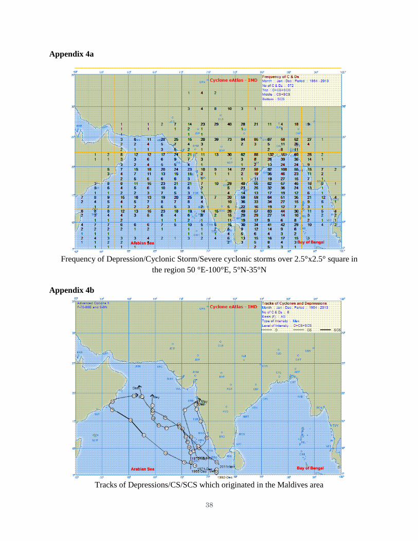
However the northern islands can be occasionally affected. Appendix 4a presents the frequency
of Depression/CS/Severe CS in the various 2.5°x2.5° squares over the region 50°E-100°E, 5°N-
35°N based on the 50 year data 1964-2013 (source: Cyclone eAtlas, IMD-India Meteorological
Department). As shown with in the longitudes 70-75°E where Maldives islands lie, the
frequencies of D/CS/SCS respectively are 10,1,1 in the area 70-72.5°E, 7.5-10°N; 3,0,0 in 5-
7.5°N; Within 72.5°-75°E the frequencies are 5,1,1 in 7.5-10°N and 2,0,0 in 5-7.5°N. Thus
south of 7.5°N the frequencies within 70-75°E are 5,0,0 whereas north of 7.5°N they are 15,2,2.
Appendix 4b presents the tracks of storms which originated in the latitudinal belt of 5-9°N in the
Maldives region during 1964-2013. As shown there have been 6 such systems.
The above analysis clearly shows that the northern islands of Maldives do carry some risk
from depressions and cyclonic storms however rare the occurrences are. Sometimes a CS moving
north of 10°N over the North Indian Ocean also can affect some of the islands under favourable
synoptic conditions. Tropical cyclone Neelam which affected the southwestern pats of Bay of
Bengal and crossed the north Tamil Nadu coast during Oct-Nov 2012, thorough moved very far
away from Maldives still affected the islands by causing flooding in as many as 50 islands.
b. Heavy rainfall: The Maldives islands receive normal annual rainfall of 200-400 cm
depending on the location and so heavy rainfall and its effects such as local flooding are always
likely.
c. Strong winds over the seas, Rough seas, high waves, high swells: As the islands lie in the
region close to the equator, winds over the sea would be relatively weaker. However during
monsoon season strong local winds could be a feature which can give rise to high waves and
rough seas. Further during heavy rain, low visibility is another risk. Inter-island transport is one
of the major activities in Maldives which could be substantially influenced by the severe weather
conditions over the sea.
d. Tsunami waves: (Not strictly a weather event but ocean generated)
The EWS for coastal multi hazard existing in Maldives maintained by the MMS is given below:
8
1) Nearly 100 personnel work in MMS and out of this 40 work in Male.
2) 5 surface observatories are maintained.
3) 8 Manual rain gauges are maintained by MMS.
4) 23 AWS/ARG with GPRS technology, transmitting weather data once in 5 minutes.
5) No pilot balloon observations.
6) One RS/RW observatory at GAN Island (0.5° S), one observation per day.
7) GTS connectivity is available. Internet connectivity is widely available.
8) One Doppler weather radar which has been installed in one of the islands, is presently
not functional.
9) Two tide gauges and two seismology meters have been installed.
10) One satellite receiving system called CMA cast is functioning in Maldives. Satellite
pictures are received from Indian and Chinese Satellites.
MMS receives International meteorological data through GTS. The websites of INCOIS,
Indonesia and Australia in which Tsunami warning messages are uploaded are accessed by MMS
to access Tsunami warning messages on real time basis. Tropical cyclone advisories are
received via GTS and also from WMO designated RSMC, New Delhi and La-Re Union. GTS,
Fax, email, internet and direct access to the website of the Advisory centres are the major sources
of communication. Local data is received through phone and SMS also.
Sufficient backup provision is available and the observatory at GAN could take the
responsibility of providing EWS in case the Hulhule (Male) observatory fails. The forecasting
office at Male functions round the clock 24 hours 7 days a week. Real time data are displayed
through the website. Climatic data is systematically archived and made available to the users.
The centre at Male handles all the weather warnings. The country has installed sufficient
equipment and sensors in place but sometimes failure of sensors do occur. Insufficient technical
expertise, lack of funds and equipment are a few other constraints.
The website of MMS, www.meteorology.gov.mv is found to be very basic with only a
handful of links. However it is just adequate and facilitates quick dissemination of the warning
messages. Marine and general weather forecasts are issued. In most of the weather forecasts
issued by MMS sea condition forecast is included. Continuous forecasts of wave and swell both
height and period are important in view of the geography of Maldives and that there are more
than 1000 islands. Some islands which are not inhabited are now used as holiday resorts for
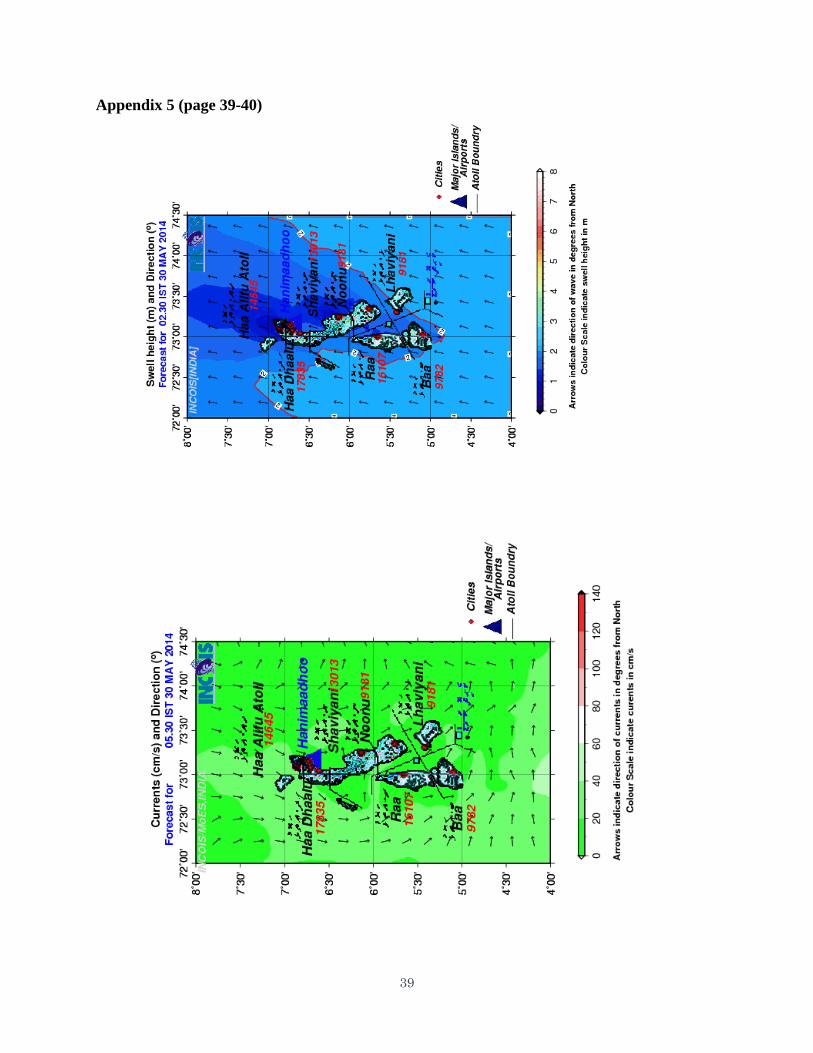
foreign tourists. In collaboration with RIMES, Bangkok, INCOIS, Hyderabad, India has issued
forecast of several ocean parameters such as wave, swell, wind, SST, current, high wave alert etc.
specifically for the islands of Maldives. The forecasts are available for Days 1, 2 and 3 for
various times for southern, central and northern parts separately. The forecasts are depicted in
pictorial form and the grid point values in text file format are also provided. This must be
considered as a major initiative by all the institutions involved i.e., MMS, RIMES and INCOIS.
Appendix 5 presents the forecasts of wave, swell wind and current available on a specific day
(30 May 2014) issued by INCOIS specifically for Maldives.
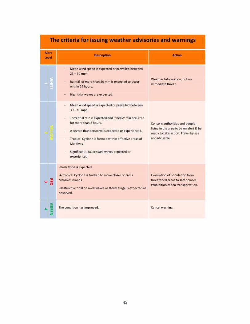
The definition of heavy rainfall, squally winds, rough seas etc., as defined by MMS are
region specific and may not be similar to the practice followed by other countries.
For Tsunami warning MMS depends mainly upon the inputs and forecast products
generated by countries such as India, Indonesia etc., which have Tsunami Observation systems in
the Indian Ocean. The website of MMS contains a link to the Pacific Tsunami warning centre of
NOAA.
9
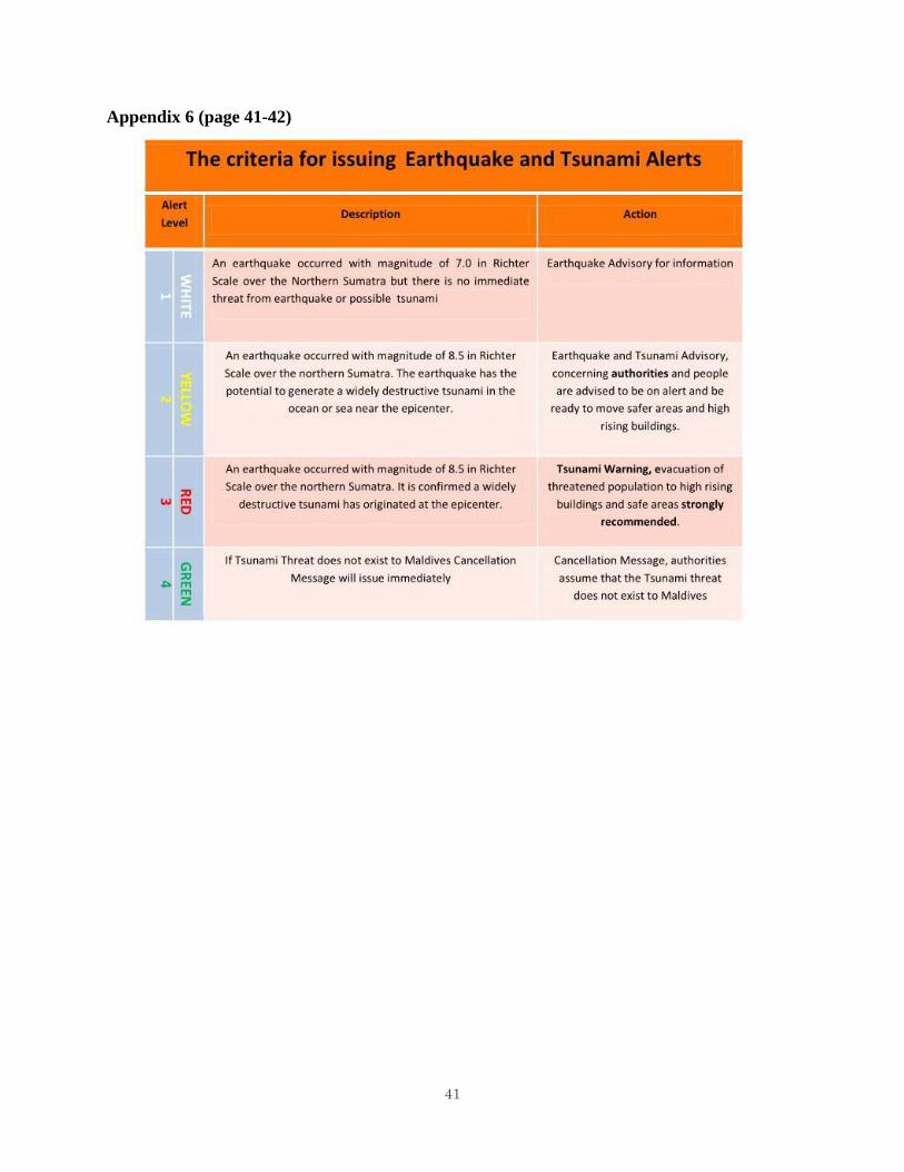
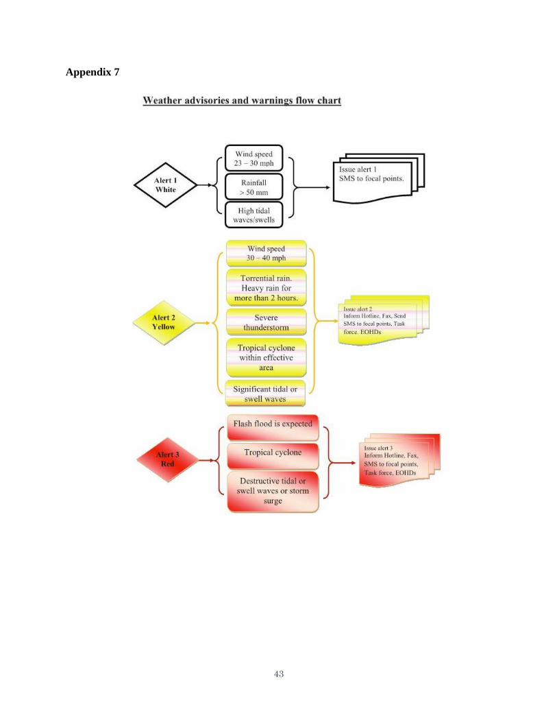
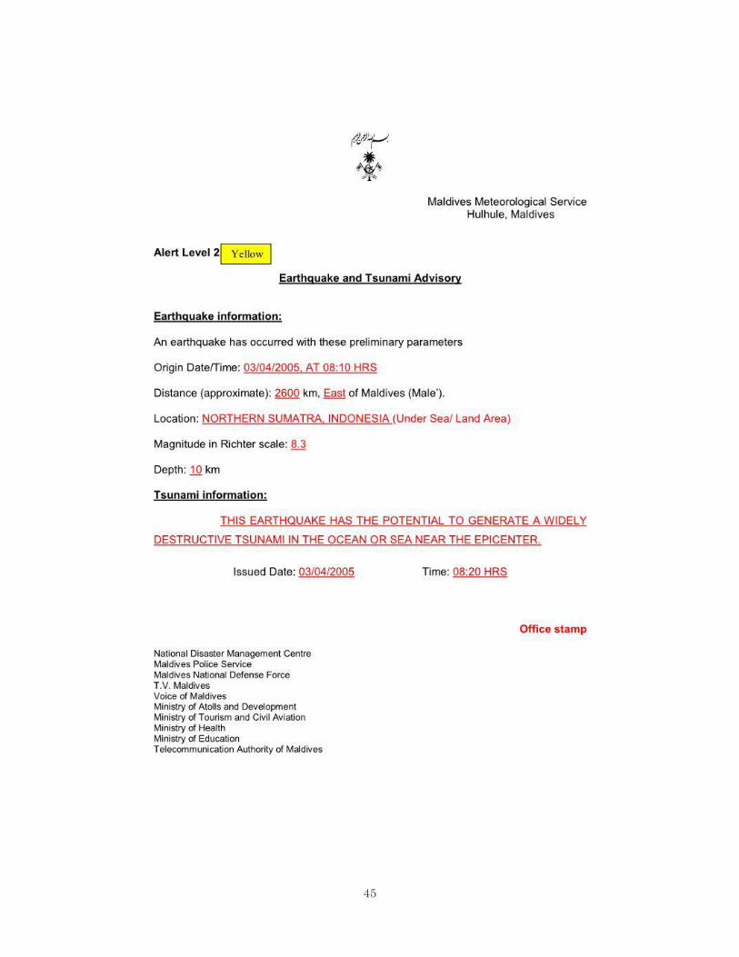
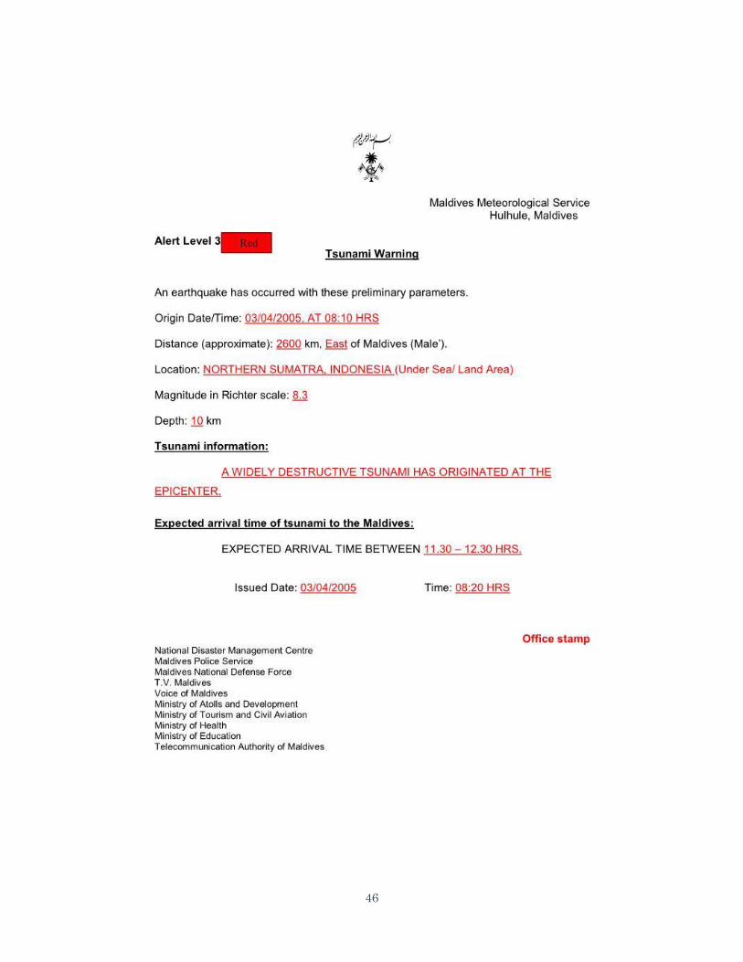
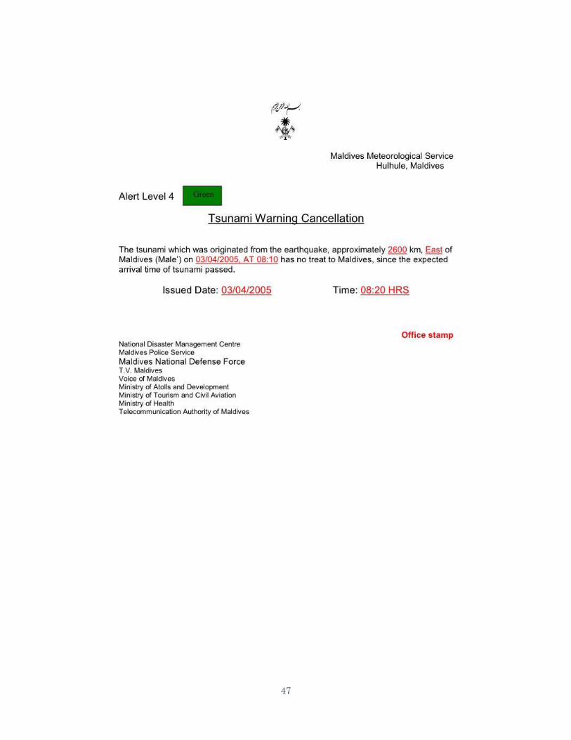
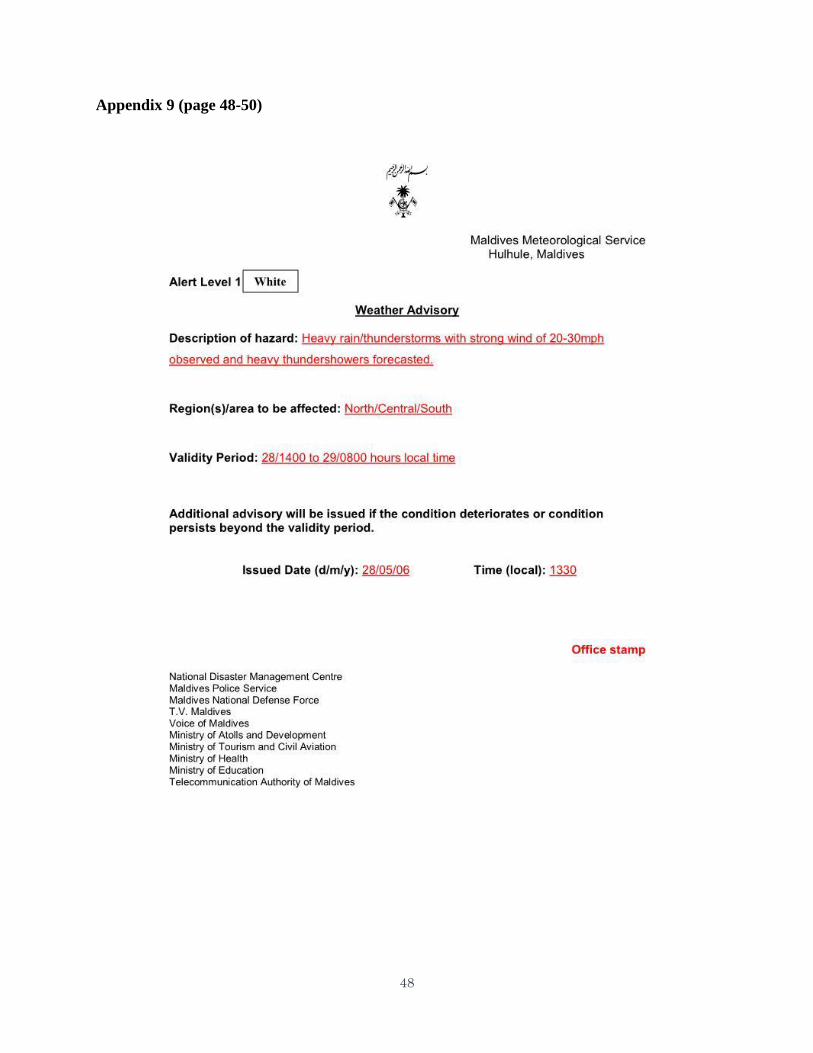
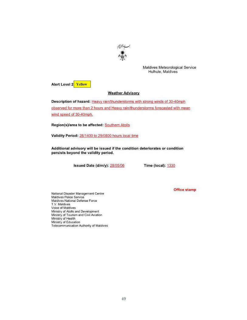
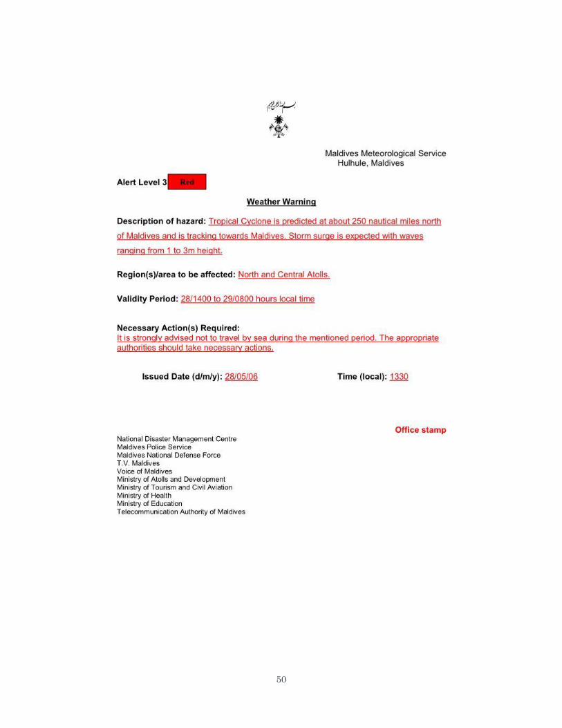
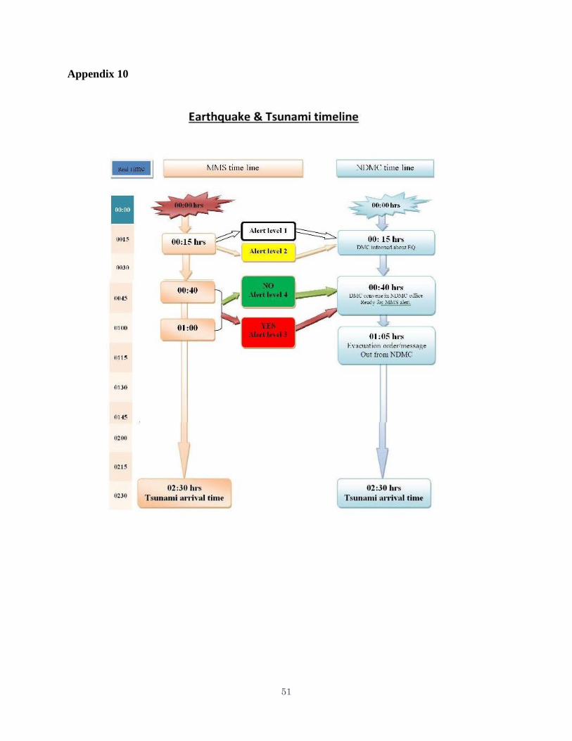
Appendix 6 presents the criteria for issuing Earth quake and Tsunami alerts and that for
issuing weather advisories and warnings. Appendix 7 presents the weather advisories and
warning flow chart. As shown, there are four alert levels, 1, 2, 3 and 4 with colour codings
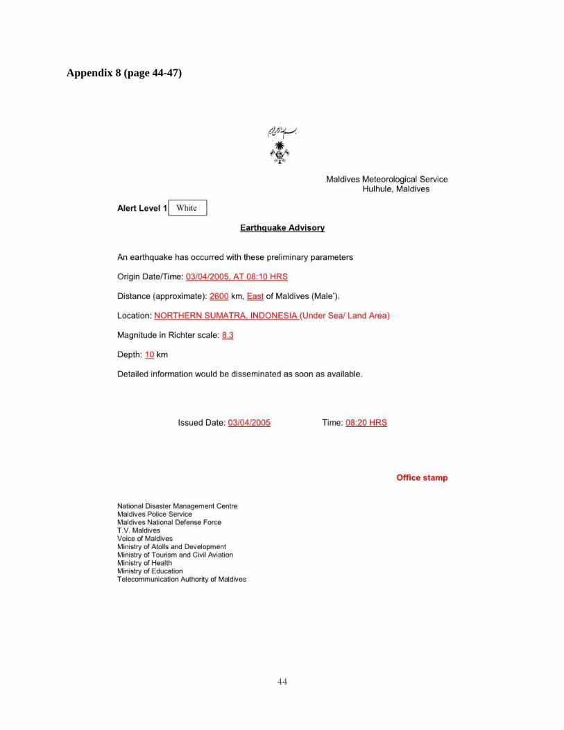
White, Yellow, Red and Green for Tsunami warning. Appendix 8 presents the sequence of
bulletins issued during the occurrence of an earthquake. The levels 1, 2, 3 indicate increasing
severity of the event with 2 upgraded as tsunami advisory, 3 as tsunami warning. Alert 4
indicates cancellation of the warning and that severe weather/Tsunami threat no longer exits. In
the weather advisory issued on 28/05/2006 (Appendix 9), the first two bulletins forecast heavy
rain/thunderstorms and the third bulletin describes the presence of a CS though located very far
away. Appendix 10 presents a timeline for issuing warnings for tsunami. The formats given in
Appendixes 8 and 9 are the two major formats where by warnings are issued by MMS to the
users, i.e., one for earthquake and tsunami and the other for weather related hazards. The
warnings are region specific to the atoll level. No island specific warnings are issued.
As for dissemination of warning messages, the National Disaster Management Centre
(NDMC) plays an important role. There have been a few other Government departments such as
Maldives National Defence force, Police services, Ministries of Education, Health, Tourism,
Local Government authority, City council, Local council etc., which are involved in the
implementation of EWS. The Red Crescent of Maldives has several branches and sub units and
plays a crucial role in ensuring last mile connectivity of severe weather warnings. They
frequently organise programmes and drills for school students. The media also plays a pivotal
role but would like MMS to provide better inputs, graphics and animation. The media personnel
present in the meet wanted further improvement in the website of MMS.
The MMS participants also informed that fisherman warnings are frequently
communicated through coast guard. VHF sets are also used. 20,000 fishermen carry out fishing
and the no. of boats is nearly 1200. There are also large no. of personnel employed in operating
the boats. All these show the importance of the sea area forecasts and the need for continuous
updates.
Best practices
Good observational organisation
A robust forecasting system
Good and efficient disseminating system of forecasts and warnings
Conducting user meets and translation workshops occasionally
NWP capacity
Utilising substantially, products available from other national weather services
Receiving forecasts of several crucial ocean parameters in collaboration with INCOIS and
RIMES.
Availability of good communication network, including network within the islands, Good
internet connectivity in most of the islands.
Trained manpower.
Systematic archival of climate data.
Gaps, needs and Recommendations
Considering that Maldives consist of several atolls and islands, a denser observational
network, fully automated (AWS/ARG) is desirable.
10
Installation of 2-3 Doppler weather radars despite high cost of procurement and
maintenance. A DWR can help in continuous monitoring of weather which could
substantially help in enhancing observational and hence forecasting capability.
Too basic website which needs enhancement.
6.2 Hydrology/EWS
6.2.1 General
a. Floods are the most frequent natural hazard in Maldives, but it is urban flooding and not
the river flooding. There is no separate flood forecasting department or division under MMS.
Flood forecast and/ or flood situation is included in the weather forecast as and when heavy rain
is expected. Floods are always associated with heavy rains, which occur due to active monsoon
or under the indirect effect of the tropical cyclone. Whenever a heavy rain warning is issued
floods are also forecast and included in the text of the warning. Flood situation becomes much
more critical when strong winds and heavy rain occur at the time of high sea tide. There is
widespread inundation under this situation with low lying areas coming under as deep as around
3 feet of water as was the case in 2012 because of 2 cyclones which affected indirectly and
caused 200 mm of rain in 6 hours. Tsunami also caused heavy and widespread inundation 80
islands were completely inundated.
b. Flood Forecasting system and flood warning criteria
Flood forecasts are included in the weather forecasts relating to the heavy rain. Heavy
rain/flood forecasts are based upon the use of meteorological charts/ maps using the data from
international sources through GTS, Fax and Internet, V-Sat communication and Broadband
network etc. Use of the satellite pictures as received from Indian and Chinese weather satellites
and that of the weather radar is made in making the rain/ flood forecast. The radar is however
unserviceable since last two years due to maintenance problems involving some costly spare
parts. Criteria for issuing heavy rain/ flood warning is in the form of issuing three colour coded
weather advisories and warnings as given here under.
1) White advisory information is issued when the rainfall of more than 50 mm is expected to
occur within 24 hours. Winds between 20-30 MPA and high tide waves are also included
under this condition.
2) Yellow advisory is issued when torrential rain is expected and heavy rain has already
occurred for more than 02 hours.
3) Red advisory/warning is issued when floods are expected (or have occurred) and also
destructive tide or swell wave or storm surge is expected or has occurred.
4) Green advisory is issued when the condition returns to normal.
6.2.2 Dissemination of weather and flood forecast
Dissemination of weather and flood forecast is done in accordance with the flow chart
titled “weather advisories and warnings flow chart” given at Appendix 7.
6.2.3 Gaps and needs
a. Presently no information relating to floods is being given. In the criteria of issuing the
weather advisory, floods are mentioned under the criteria for the red advisory. However it is not
clear as to whether it is a stage when the flood have actually occurred or it is a stage when the
11
flood is expected. Even though in the given criteria for the red advisory it is mentioned as “flash
flood is expected” but under the yellow advisory stage it is mentioned as “torrential rain is
expected and if heavy rain occurred for more than two hours”. It is thus obvious that if the
criteria for the yellow warning stage has been fulfilled, then floods must have occurred even
within the yellow stage prior to the red stage condition. Therefore, this is an anomaly, which
needs to be removed.
b. Recommendation
The criteria for the yellow stage relating to the heavy rain and floods need to be amended
to include the occurrence of floods as well. The amended criteria may read as “torrential rain and
floods is expected or heavy rain and floods have already occurred”. Similarly under the red stage
instead of the mention that “flash flood is expected” it could be mentioned as “flood has
occurred”.
6.3 DRR/EWS
6.3.1 General
As a part of the SSOP Mission meetings both combined as well as separate were held
with all relevant stakeholders of Maldives which mainly included representatives from NDMC,
MNDF, Fisheries and Agriculture, Fishermen Association, EPA, Climate Change, Tourism and
Education, Maldives Red Crescent, Media, Local Government Authority, Fishermen, Regional
Airports, Health Protection Agency, Boat Captain etc. All relevant issues were shared by the
participants. Representatives of Defence Forces, Maldives Red Crescent, and Fishermen
Association showed special interest in discussing the DRR and the Response system put in place.
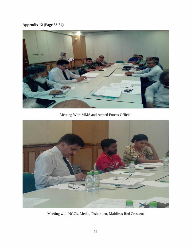
Appendix 12 depicts some photos of Mission’s engagement in Maldives.
6.3.1 Disaster Risk Reduction
a. Disaster Risk Scenario
The disaster risk scenario for Maldives can be described as moderate in general. Despite
this, Maldives is among the most severely affected countries hit by the Asian Tsunami on
December 26, 2004. The Maldives experiences moderate risk conditions owing to a low
probability of hazard occurrence and high vulnerability from exposure due to geographical,
topographical and socio-economic factors.
Maldives has tsunami hazard largely from the east though relatively low hazard is from
the north and south also. So, islands along the eastern fringe of eastern atolls are at greater
hazard. Islands along the western fringe of western islands have relatively low tsunami hazard.
Historically, Maldives has been affected by three earthquake sources in the Indian Ocean. Of the
total 85 tsunamis generated since 1816, 67 originated from the Sumatra sub-duction zone in east
and the remaining 13 from the Makran coast zone in north and Carlsburg Transform fault zone in
south. The northern atolls are at greater hazard from cyclonic winds and storm surge. This
reduces gradually to very low hazard in southern atolls.
Sea level rise due to climate change has uniform hazard throughout the country. The IPCC
in its Third Assessment Report 2001 estimates a projected sea level rise of 0.09 m to 0.88 m for
1990 to 2100. The impact on Maldives is directly proportional to the elevation of Islands. With
about three-quarters of the land area of Maldives less than a meter above mean sea level, the
12
slightest rise in sea level will prove extremely threatening. Male is estimated to be inundated by
15% by 2025 and 50% by 2100 under conservative scenarios of climate change.
Overall, Maldives has moderate hazard levels except for the low probability and high
consequential tsunami hazard in the near future, and high probability and high consequential Sea
level rise hazard in the distant future.
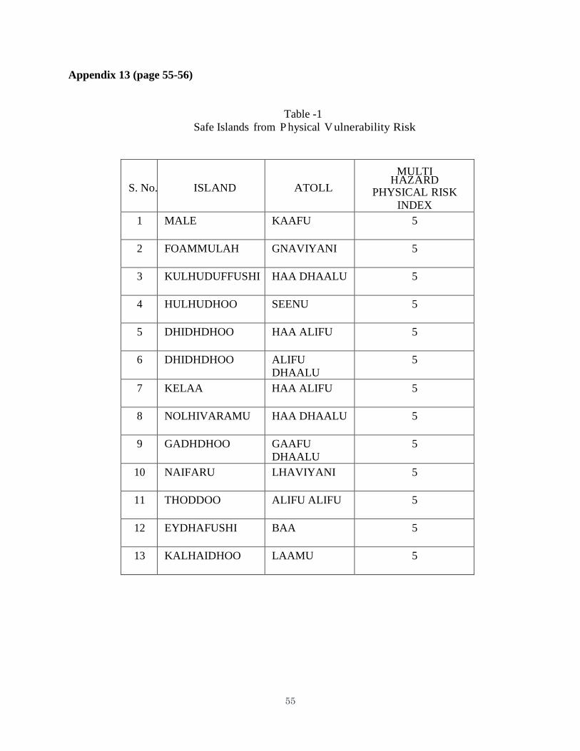
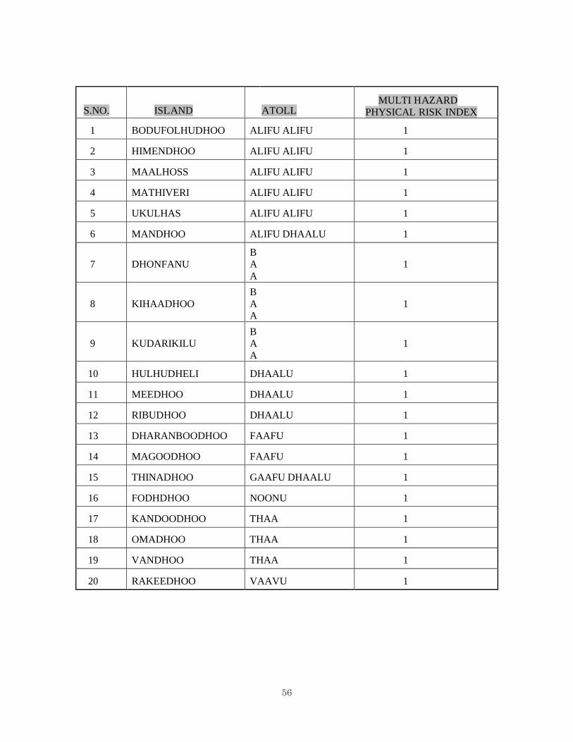
b. Risk from Physical Vulnerability
Risk from physical vulnerability is more a function of exposure concentration. As such
Male tops the list with highest risk. The islands with risk index 5 (very high) and risk index 1
(very low) are given in the Table-1, Appendix 13 below. Risk index 1 means “safe island”. Risk
from social vulnerability has no significant trend except Male being in low risk. The risks are
randomly spread across the country as several factors drive the vulnerability.
6.3.2 Disaster Prevention, Mitigation and Preparedness
Government has undertaken new initiatives to change its focus from the traditional
approach to Disaster Management:
Beginning with the Disaster Management Bill that is in the process of finalization. The
Bill seeks to provide a platform at all levels to address disaster risk reduction.
The Government has developed conceptual designs for enhanced mitigation features on the
proposed ‘Safe Island’ concept.
Population consolidation and the creation of safe islands are part of the solution to climate
change as discussed in the 7th National Disaster Management Plan.
Formulation of the second National Environmental Action Plan (NEAP) identified
issues that have to be addressed for proper environmental management.
The NAPA under the integrated Climate Change Strategy (CCS) is an attempt by the
Government to develop a countrywide program that encompasses immediate and urgent
adaptation activities that address current and anticipated adverse effects of climate change.
The Health Master Plan 2006-2015 identifies policy direction and goals for national disaster
preparedness at all levels of the health sector.
The education sector has included the focus on Disaster Management under the policy
guidelines of providing safety for children.
The Government’s Telecom Policy emphasizes on an Emergency Communication Plan and
the department is working in this direction.
6.3.3 Building Resilience to Hazards
Following the Tsunami, a National Disaster Management Centre was established to
facilitate the response and coordination. The Ministry for Defense and National Security,
Ministry of Finance, Ministry of Planning and National Development lead the emergency
response and relief efforts in collaboration with other departments, UN agencies and other
development partners. NDMC is the focal point for response, relief and recovery activities.
NDMC is carrying out a more holistic model, wherein the processes of hazard identification and
mitigation, community preparedness, integrated response efforts and recovery are planned for
and undertaken contiguously within a risk management context to address issues of
vulnerability. More than 200 staff representing ministries in the government has been
trained on basic concepts of disaster management and other subjects related to disaster
13
management carried out at national and internal levels. Community preparedness plans have
been developed in 30 islands and disaster management task forces instituted with training on
basic emergency response as part of the Community Based Disaster Program.
6.3.4 Mainstreaming DRR into Design and Implementation
The ambitious concept of “Building Back Better” – a phrase coined by former US
President Bill Clinton in his role as UN Secretary General Envoy for Tsunami recovery – has
been the guiding principle in the recovery and reconstruction program. Building Back Better
envisions the kind of society that people of Maldives will enjoy in five, ten and even fifteen
years. Some of the features for building back better include utilization of cast concrete elements
for quay walls that would replace the original structure made of ‘gunny sacks’. The National
Recovery and Response Plan (NRRP) was an important tool for guiding the government’s efforts
in responding to the Tsunami. School level Standard Operating Procedures (SOPs) were
completed for most schools in the country with staff being trained on emergency preparedness
and decentralized management including regular mock drills being conducted within the school
as well as activities carried out for community awareness with the involvement of parents in
DRR. Ministry of Health and Family have specific SOP for the health sector while Ministry of
National Defense Force, Ministry of Tourism, Arts and Culture SOPs in place for their
respective sectors.
Best Practices
Good progress has been made by the Government to establish and equip national
institutions such as the National Disaster Management Center (NDMC) and sectorial
agencies to institutionalize disaster risk reduction.
The Disaster Management Bill, National Development Plan and subsequently the Strategic
National Action Plan (SNAP) for DRR and Climate Change Adaptation highlights the
Government’s commitment of ensuring that key development plans, strategic and legislative
frameworks are in place to adequately manage disasters in the country.
The SNAP was designed to promote collaboration among policy makers, experts and
practitioners of disaster risk reduction and climate change adaptation in the country for
the development of a comprehensive risk management approach. It aims to build resilience
of the nation and the island communities to disasters by sustaining the progress made by
consolidating learned best practices and by incorporating risk reduction into the strategy for
decentralization.
Government’s Decentralization Act 2010 was a positive effort of defining three-tier
administrative constituencies consisting of city, atoll and island councils to pave the way for
decentralized DRR responsibilities. All these policies, plans, strategies and legislative
frameworks were considered necessary to also facilitate budget allocation.
For capacity building, human resource is being developed with funds being allocated for
various technical training. Maldivian Red Crescent funding contributed to 25 trained
individuals in the vulnerability capacity assessment.
The Decentralization Act gives sectorial agencies the mandate for decentralization of DRR at
sub-national government levels to also promote community participation. Further the local
14
government authority’s mandate is for relief and recovery. Clearly, the legal provision for
decentralization exists however ownership of the processes is at the national level with few
agencies making gradual progress to implementation it.
Other DRR related activities undertaken by MoE in collaboration with Care Society includes
First Aid training for teachers and students. School health and safety training have been
conducted in 13 islands, establishment of child friendly schools are in progress whereas the
guidelines to abide by in cases of Natural Hazards and Man-made disasters have also been
sent to atolls. These guidelines are available in the MoE website.
Further, the Maldivian Red Crescent (MRC) has established five branches in Male and 12
units established in 12 atolls while training program produced more than 150 First Aiders, 2
Regional Disaster Response Team (Red Cross and Red Crescent) members, 2 Search and
Rescue Trainers, 3 Community Based Disaster Risk Reduction Trainers with more than 30
Vulnerability and Capacity Assessment (VCA) volunteers and staff were trained.
Furthermore, VCA trainings were conducted in all units of MRC with community action
plans by MRC.
Safe houses/shelters were constructed in 5 islands namely: Dhuvaafaru in Raa Atoll, Muli in
Meemu Atoll, Gan and Fonadhoo in Laamu Atoll and Vilufushi in Thaa Atoll.
Maldivian Red Crescent has trained special teams who are deployed across the country that
can provide basic search and rescue; first aid, triage and coordination.
Maldives / Male Water and Sewerage Company – Pvt (Ltd) was initially mandate was to
supply water to Male only. Now to 8 islands both water supply and sanitation services are
being provided. Also now, it is providing electricity to one island and has established
UNOCHA’s standards. The Company is preparing Evacuation Plan and the Recovery Plan as
for selected islands. All these are monitored by Emergency Response Teams. Committee of
the Company overlooks the response and preparedness for the natural and man-made
disasters. Water and sanitation system gets corrupted after disasters which the Company is
also planning to address. The company has got good anti-fire system as well except for 2-3
islands. Remaining shall also be covered. As a part of Contingency Plan, the company is
working on the enhancement of water supply storage, expansion of the pumping network and
from next year on-wards they shall be developing more pumping systems.
Maldives Transporting and Contracting Company has a major role in harbor is dredging and
sea transport, and major role in evacuation. Their main partners are National Defence Force
and Police. SOPs and trained staff are there along with equipment. Workforce and equipment
is limited at harbors and islands. Back up is perfect in Male. Beach erosion, high tides are the
issues. Erosion taken care by EPA.
Gaps and Recommendations
Key gaps found include:
The inadequate capacity limits a holistic approach to implementation of DRR measures. This
is exacerbated by delayed endorsement of the DM Bill to give national institutions the legal
mandate to effectively coordinate implementation of DRR initiatives in the country.
The Decentralization Act is focused on emergency response and does not promote an
integrated approach which local councils can advocate as many are currently formulating
development plans at the sub-national levels.
The current budgetary allocation to key sectorial agencies and different levels of government
15
is insufficient to effectively promote an integrated approach DRR. Further to limited capacity
at the national level, there is ongoing lack of capacity in local government authorities to assist
island councils in addressing DRR in their development planning process. This limits further
investment in capacity development and acquisition of key equipment for adequately prepare,
prevent and respond to disasters in the country.
To date, less than 5% of islands focus on community DRR Drills and around 20 % of the
islands development plans have integrated DRR in their development plans.
Further gaps exist for Government to have a comprehensive national hazard risks assessment
and information system to inform sectors and communities to take effective action on DRR.
The limited information on disaster risks affects well informed support for planning and
decision-making by Government and other agencies. Coupled with this are limitations in staff
capacity to collate, interpret and analyze relevant data and carry out risk assessments.
The national database hosted by National Disaster Management Centre has remained been
under repair. Associated with this is lack of technical expertise that hinders implementation of
data compilation and management. Owing to financial and logistical difficulties a number of
Automatic Weather Stations (AWS) are not in operation. Doppler Weather radar at Hulhule is
also out of service, as a result of unavailability of financial resource and technical support.
Due to lack of financial resources MMS is unable to provide repair and maintenance training
to technicians working in this key area. Some photos of various products of Maldives
Meteorological Services are attached at Appendix14.
Maldives has ad-hoc mechanisms to disseminate information on disasters and disaster risk
reduction to communities and general public. The Maldives Meteorological Services and
Ministry of Health website provides updated information on weather changes, onset of
disasters/epidemics and ongoing disasters when it occurs. However, the public awareness of
the information update on these two websites is limited.
There is insufficient technical capacity at island and atoll level to implement the plans and
conduct drills. Consequently, schools also face constraints in funding allocation for disaster
management and drill activities.
Inadequate awareness and advocacy on the importance of disaster preparedness contributed to
lack of systematic institutionalization of disaster preparedness and contingency planning in
key government agencies.
The absence of a legal framework for DRR affected enforcement of key requirements to
prepare and respond to disaster in a cost-effective way. Consequently, inadequate human and
institutional capacity with ad hoc preparedness and response interventions increases the level
of vulnerability particularly for people in remote and isolated atolls and islands.
In Male, the Sewer network is an old one. Population has exponentially expanded when
established 9 Sewer pumping system (then the population was 20,000, now the population is
100,000. Major vulnerabilities in this context include: i) Over capacities due to entry of flood
water, ii) Contamination, iii) Threat of water / flood not coming; iv)Limited pumping
network unable to get rid from the water; v) Sea water intrusion.
Girls School / Amenia School – Male has an old building – ceilings are weak. The school has
its own SOPs which are being modified. The school has no place to evacuate the students
from disasters. New SOPs are being written to include evacuation routes once it is needed
due to emergency. Ministry of Education, NDMC and Maldives Red Crescent all are aware
of the SOPs. Ministry of Defence have made assessment for the building. Buildings are in
bad stages / shapes and should be revamped on regular time interval. Vulnerability of the
16
building is from fire, unrest. Awareness programs are needed. Earthquake awareness needed.
Drawback in the implementation of SOPs is always observed.
Recommendations
Some key recommendations include:
Proactive Disaster Risk Mitigation: The hazard and risk information needs to be
incorporated into the national policy and planning. Proactive planning and investments in
mitigation measures – structural and non-structural go a long way in mitigating the long term
impacts of natural disasters. A beginning needs to be made to construct buildings and
structures that can resist natural hazard forces at least in zones 5 and 4. Islands should be
carefully selected for the development activities based on the hazard and risk information.
Community Based Disaster Risk Management: In Maldives, inhabited islands with small
populations may be targeted for building community’s capacity to face natural disasters. This
would require suitable training for Island Chiefs and Atoll Chiefs. Island-wise disaster
management plans would be a useful starting point with activities like preparedness drills
included. Other influential local stakeholders such as school teachers, religious heads and
boat owners would also need to be targeted with customized training programs and related
activities.
Basic Disaster Awareness: This is to encourage families to have their own disaster plans,
communities to build emergency water and food supply systems and house
owners/construction workers to be sensitive to safe building construction practices should be
promoted through awareness programs using various locally appropriate media.
Early Warning Dissemination: In Maldives, the northern atolls are at high risk to cyclones
and the southern atolls are at risk to Tsunamis. The communities in these atolls need to be
well prepared to receive warnings promptly and react appropriately. The island offices and
well established GSM network in the country are potentially the most useful tools for warning
dissemination. Requisite infrastructure and training is needed to promote better preparedness.
Appendix 14 depicts some of the Early Warning Dissemination Products presently being
maintained by MMS.
School Safety and Hospital Casualty Drills: There is an urgent need for introducing school
safety programs in all the islands. The country has a robust educational infrastructure which
may be suitably equipped to deal with natural disasters. School safety programs would
promote a culture of safety in the community. Program may cover multi-hazards, and may
include: i) Training of Teachers and students, ii) Formal curriculum based education, iii) Non-
formal aspects such as school disaster management plans, preparedness drills, structural and
non-structural mitigation exercises.
A systematic awareness and education on DRR is needed to enhance the knowledge and
skills of stakeholders to give DRR the levels of attention in overall development planning and
budgetary response it requires. Also an emphasis on the local government authorities in terms
of funding and resources is essential given their proximity to local communities.
It is recommended that provision of training on DRR to government, civil society
organizations and private organizations is critical to enhance capacity and retain the trained
staff.
A lead technical agency may be constituted to support the functions of National Disaster
17
Management Center to collect, interpret and analyze risk information besides to make available
reports and documents in the Disaster Risk Assessment for policy and decision-makers.
Provision of necessary support to enhance national capacities to carry out the task of
operating an integrated database system. Improved allocation of sufficient funds for
maintenance of scientific equipment used at MMS is also vital to maintain the systems
operational for the continuous monitoring of natural hazards which may affect the country.
Further, international assistance and support is required to provide training for the staff in the
responsible agencies in Disaster loss data management and repair and maintenance of hazard
monitoring systems.
Maldives need to develop a strategy for dissemination of updated disasters including risk and
preparedness i.e. a Disaster Information System to the public and communities. This can be
supported by the set-up of an updated and well organized website by the National Disaster
Management Centre (NDMC).
It is recommended that availability of information on the website is widely marketed and
encouraged for use as well as monitoring usage and access to the website to keep count users.
The media need to take an active role in supporting delivery of information on disasters, their
risks and required preparedness messages to the public. This should be done through Maldives
Broadcasting Commission.
All schools are provided with a specific allocation for disaster management activities in
schools and fully utilize teachers for DRR as many have been trained.
Priority be assigned in establishing a research unit within existing institutions to conduct
studies into the relevant DRR areas with local academics. Efforts should be geared towards
set up of a multi-sectorial platform led by National Disaster Management Centre for easy
access to the public including sectors for their own purposes.
Initial efforts of the civil society organizations with key government agencies to support
communities’ needs to be strengthened to scale-up disaster preparedness and contingency
planning.
Future investments are necessary to formalize existing institutional mandates to facilitate easy
access to available capacity and resources in the country to promote whole of government
approach on disaster preparedness and response programs
No comprehensive system exists to effectively coordinate the dissemination of information
after a hazard event has been formulated and is in the process of being commissioned. As a
result, there has been ad-hoc information sharing hence it is important to establish the system
as soon as possible including alternative communication system for outreach to atolls and
islands.
There is a centralized system of warehousing in Maldives (only at Male level). This needs to
be taken to the district/island level.
Dire need to have special system / drainage system for the collection and resending/drainage
of the sea water again into the sea. Tsunami may cause damage to water supply and
sanitation system.
7. Standard Operating Procedures
7.1 Meteorology /SOP
The consultants had access to the following SOP documents being used by MMS and
other related departments, for the management of Multi hazard weather events.
18
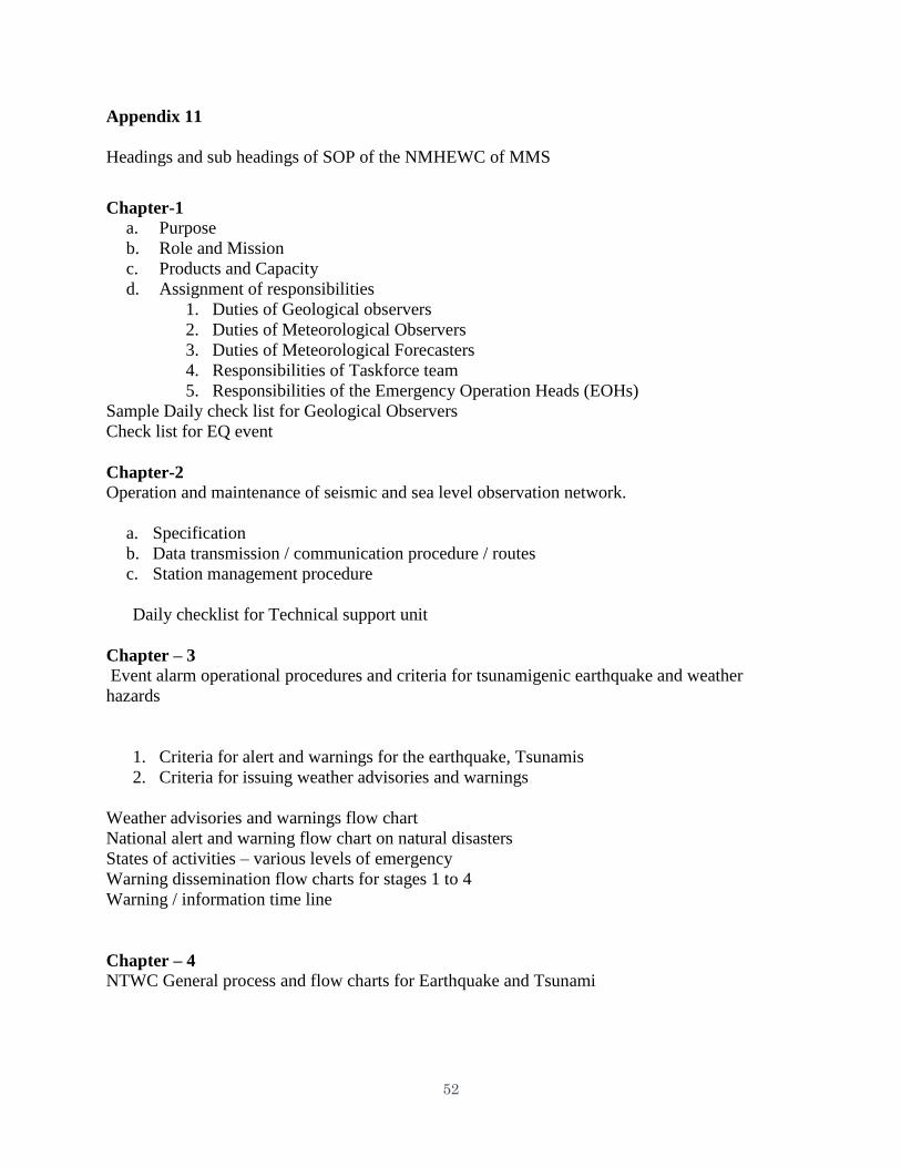
a. SOP published by National Multi Hazard Early Warning Centre (NMHEWC), MMS
which contains 4 chapters in 25 pages. The full document is enclosed as Annexure 1. The sub
headings of the SOP are given in Appendix 11. As shown this well drafted SOP contains
sections titled as: purpose, assignment of responsibilities, duties of meteorological observers and
forecasters, check list of earthquake events, operational procedures for Tsunami and weather
hazards, criteria for issuing weather advisories and warnings, weather advisories and warning
flow chart, Alert and warning flow chart, warning dissemination flow chart, warning
dissemination flow charts at stages 1,2,3, Warnings / Information time line flow chart (Appendix
10). It also includes several flow charts of the various aspects of warnings. When the alerts are
to be issued for various levels are clearly mentioned. Colour coding for different levels are also
included. There are 4 levels for Earthquake / Tsunami and 3 levels for weather advisories.
b. An SOP for dissemination Tsunami warning bulletins – recently updated 27 pages
(Annexure 2)
c. An SOP for MHEW prepared exclusively for schools 15 pages (Annexure 3)
d. SOP for MHEW prepared exclusively for the tourism sector (Annexure 4)
The above SOPs are well written, contain detailed instructions and include several flow
charts. They generally satisfy the requisites of SOPs which could be adopted for inclusion in the
SSOP manual. Integrated SOPs are however not available.
SOPs for issuing warnings for cyclonic storms, heavy rainfall and sea conditions could be
still more detailed. Cyclone warning procedures are not fully covered. An SOP for cyclone
warning for a country like Maldives consisting of more than 1000 islands, would be substantially
different from a cyclone SOP which suits countries such as Sri Lanka and India. All the port
warning signals and procedures cannot be adopted in to to, as a cyclone crossing the coast is not
clearly defined for Maldives.
The MMS has been rendering excellent multi hazard early warning services to Maldives
for severe weather events. Detailed SOPS have also been prepared for weather related hazards
and tsunami specifically for schools and tourism sector. The SOP for weather warning
procedures could be more detailed. There is also the requirement of an SOP for cyclone
warning, as howsoever rare is the occurrence of cyclones/depressions in Maldives, they can still
affect the northern islands. Further swells resulting from even a distant cyclone can affect all the
islands.
There is sufficient material available in the various SOPs prepared by MMS which could
be considered for inclusion in the SSOP manual. SOPs prepared for other counties when used
for Maldives will definitely require specific customisation owing to the geographical location of
Maldives and that it is a union of large number of very small islands.
Best practices
The SOP for National multi hazard early warning centre, MMS, is a detailed, well drafted
document. It contains detailed SOP for warning of weather hazards, Tsunami and
Earthquakes
Considering the importance of Tourism industry to the Island’s economy, separate SOP
has been prepared for Tourism Industry to follow in the event of severe weather
Separate and detailed SOP for schools
SOPs clearly state the format, process and procedures for each warning
SOPs clearly specify the follow up action to be taken
19
SOPs undergo frequent updating
SOP refresher trainings are conducted
Strict monitoring of the implementation of the SOP
Gaps, needs and Recommendation
SOP for several weather events such as heavy rainfall, rough seas could be more detailed
and exhaustive
A detailed SOP for cyclone warning including port warning should be available. Such an
SOP should be prepared taking into consideration the low latitude location of the islands
besides the fact that Maldives is a union of large number of small islands and atolls
7.2 Hydrology /SOP
a. No special SOP for hydrological disaster like floods etc. exist, since no flood forecasting
functions are provided by the MMS.
b. Gaps/need
Since floods are associated with heavy or even moderate rain in Maldives, it is necessary
to inform the people of the level of flooding expected on account of rain spell being forecast.
However this calls for some study of the past events to establish the relationship of the incident
rainfall with the flood water level on the ground. This requires the water level data of the past
rain events, which is currently not available. It is therefore recommended that water level
recording at some representative location in Male (Maldives) may be started so as to obtain
sufficient data to enable formulation of relationship between incident rainfall and the water level.
7.3 DRR/SOP
The Government’s National Development Plan and Strategic National Action Plan on
Climate Change Adaptation and Disaster Risk Reduction are the overall policy and planning
framework for DRR in the country.
Other partners such as the UN and civil society organizations have supported the government
on developing contingency plan in different sectors.
The established institutions’ technical capacity varies among the different sectors where some
have more technical expertise and equipment whereas others are not fully equipped.
Ministry of Tourism, Arts and Culture – developed detailed Standard Operating Procedures
(SOPs) for Hotel Operator authorization on Disaster Management.
Ministry of Health and Family - Standard Operational Procedures for Government agencies
were developed when a large percentage of employees fall victim to an epidemic and private
sector. This will in operation once the Public Health Bill that outlines the actions to be
undertaken during the epidemics is completed.
H1N1 SOPs were developed for schools and health facilities.
A national pandemic influenza preparedness plan and Tsunami SOPs were also developed.
Overall, the Public Health Bill once endorsed will give Ministry of Health the mandate to
enforce health protection measures in emergency and non-emergency situations.
The Ministry of Education has completed and implemented the School Emergency Operation
Guide for most schools in the country.
Vessels and aircrafts located in four regions in the country for different purposes are ideally
20
suited for search and rescue teams as well as medical evacuation. Necessary SOPs in this
context are required to be prepared and enforced.
National Disaster Management Center has a focal point in each of the inhabited islands and
an agreement has been formulated by the NDMC with the Communication Authority of
Maldives, CAM, to shut down the normal phone system and to switch on the emergency
system during a disaster so that emergency communications can take place among the focal
points.
Ministry of Education has a guideline for School Emergency Operations Procedures (SEOP),
through which schools in 12 atolls have drafted SEOPs and conducted drills involving school
children and teachers in 2011. Consequently, 13 more schools practiced drills in 2012.
Although School Emergency Operations Procedures (SEOP) has been set in numerous
schools, there is insufficient technical capacity at island and atoll level to implement the plans
and conduct drills. Comprehensive action needs to be taken in this regard.
The Ministry of Education (MoE) at the regional level has mandated all educational
institutions to produce Standard Operating Procedures/Plans (SOPs) and operate at
community level during the initial phase of emergencies. Further, MoE has prepared
operational procedures during school emergencies to all schools, personalized to respective
islands. This included training of one staff from 75% of schools in responding to disaster as
education focal points.
Formulation of technical guide to carry out the disaster risk assessment process in a
standardized format and systematic matter needs to be given priority.
The meet overall challenges towards disaster prevention, mitigation, preparedness and
vulnerability reduction SOPs are required to be formulated to address: a) Weak institutional
establishments to integrate at all levels of government; b) Inadequate awareness and advocacy
including gender sensitive policies and plans; and c) Limited capacity to interpret technical
information into analysis to guide development planning and policy design;
Maldives is at the infant stage of systematically contributing to building resilience to hazards
due to various factors and one being Disaster Management was not a top priority until the
lessons learnt from the Tsunami in the region. Standard SOPs are required to address issues like:
a) No clear mandates for coordination, monitoring and reporting; b) Inadequate funding and at
times financial restrictions and shortfalls; c) Inadequate human capacity in terms of new and
emerging disaster preparedness, prevention and response under DRR strategies as well as
limited technical expertise available in country; d) No legal framework on DRR
Prior to the Tsunami, emergency preparedness and response programs in the reconstruction
were quite new in the country and highly likely to gain momentum however the main
challenge remains in the different sectorial codes of practices, guidelines and standards as
there is no formal mechanism for tracking and reporting. Hence this would require
comprehensive guidelines/SOPs.
National Geographic Information System is not yet capable to utilize information to identify
risks/hazard zones. The NGIS needs to be enhanced to make such information available to
ensure that the decisions are fact based. In this regard easy-to-understand SOPs are required.
If something happens in mid-night then no one is listening the radio/TV. So no way at this
time to issue / forewarn the people at mid night. Necessary changes in the existing
procedures/SOPs are needed.
Evacuating the people to deep sea may be one of the good SOP
Evacuation from Island to Island is very difficult. This needs to be proactively taken in hand
21
through well thought out SOPs.
There are routine broadcasts from MMS. Based on frequency, urgency MMS relay /
broadcast the warnings. MMS needs to build its image within the people through enhanced
engagement with the media. For that matter awareness programs are required to educate
public etc. Standard SOPs are required in this context.
MMS should immediately have a Media Spokesperson. Standard SOPs for effective Media
engagement on DRR/DRM be prepared and enforced.
No written SOPs for Police. Only instructions of NDMC are followed. There are 72 police
stations in the country. The Police has terrestrial communication system. All the islands do
not have Police stations. During disaster, Ministry of Defence actions are implemented and
there is law and order situation at times. SOPs have been drafted with Airports Company
(how to act during disasters for airports). The purpose of the Airport Emergency Plan
document us to, set out the responsibilities and required actions/role of various personnel
agencies involved in dealing with contingencies affecting the airport. Draft Airport
Emergency Plan is attached as Appendix 15
8. Conclusions
The purpose of the workshop was to review existing coastal multi-hazards EWS SOPs of
hydro-meteorological service, disaster management, media, elected official, and others from
national to district to local levels; identified best practices, gaps and needs, and recommendations
for internal and cross-cutting SOPs; and then to compile data, information, examples, and
diagrams collected on SOPs best practices, gaps and needs, and recommendations for inclusion
in the Manual on Synergized Standard Operating Procedures (SSOP) for Coastal Multi-Hazard
Early Warning System which will meet the needs of the 13 beneficiary countries involved in the
Project. These purpose have been met and were described above.
Now the challenge is to take the information from these six missions and develop a
Manual/Handbook of Synergized Standard Operating Procedures for Coastal Multi-hazards
Early Warning Systems focusing on the hydro-meteorological aspects to meet the needs of
diverse users and to create a Manual that can and will be used. This development will be done in
collaboration and coordination with the five consultants, the beneficiary countries, the Task
Force, the TC Advisory Working Group, and 7 partner organizations. This Manual/Handbook
will then form the foundation for the training and working meeting scheduled under Activity 2 of
the project.
22
List of Appendixes
Common
1a. Originally planned schedule of meets for Days 1 and 2
1b. Slightly modified schedule as drafted for Maldives
2. List of participants
Met
3. Geographical location of atolls and islands of Maldives
4a. Frequency of Depression/Cyclonic Storm/Severe cyclonic storms over 2.5°x2.5° square in
the region 50 °E-100°E, 5°N-35°N, 1964-2013
4b. Tracks of Depressions/CS/SCS which originated in the Maldives area, 1964-2013
5. A section of sea forecasts issued by INCOIS (in collaboration with RIMES) for Maldives
6. Criteria for issuing Earth quake, Tsunami alerts and weather services and warning flow
chart
7. Weather advisories and warning flow chart
8. Earthquake and Tsunami advisories Alert Levels 1,2,3 and 4
9. Weather advisories – Alert levels 1,2 and 3
10. Earth quake and Tsunami time line
11. Headings and sub headings of SOP of the NMHEWC of MMS
DRR
12. Photos of Mission’s engagement in Maldives
13. Table-I Safe island from physical vulnerability risk
14. Photos of various products of MMS
15. Airport Emergency Plan, Male Airport – Section 10
23
Annexures
1. SOP published by NMHEWC, MMS ( enclosed)
2. SOP for disseminating Tsunami warning bulletins
3. SOP for schools
4. SOP for the tourism sector.
(annexures 2-4 not enclosed)
Appendixes (General)
Appendix IA Guide to Writing Effective SOPs
Appendix II Checklist for Effective SOPs for EWS
Appendix III Information on Early Warning System Overview
Appendix IV Early Warning System Checklist Items
Appendix V General Basic Information on EWS for NHMS, Warnings, Communications, and
Relationships
24
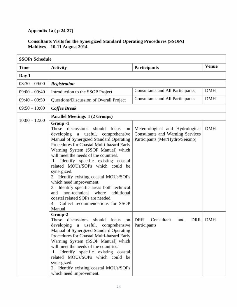
Appendix 1a ( p 24-27)
Consultants Visits for the Synergized Standard Operating Procedures (SSOPs)
Maldives – 10-11 August 2014
SSOPs Schedule
Time Activity Participants Venue
Day 1
08:30 – 09:00 Registration
09:00 – 09:40 Introduction to the SSOP Project Consultants and All Participants DMH
09:40 – 09:50 Questions/Discussion of Overall Project Consultants and All Participants DMH
09:50 – 10:00 Coffee Break
10:00 – 12:00 Parallel Meetings I (2 Groups)
Group -1
These discussions should focus on
developing a useful, comprehensive
Manual of Synergized Standard Operating
Procedures for Coastal Multi-hazard Early
Warning System (SSOP Manual) which
will meet the needs of the countries.
1. Identify specific existing coastal
related MOUs/SOPs which could be
synergized.
2. Identify existing coastal MOUs/SOPs
which need improvement.
3. Identify specific areas both technical
and non-technical where additional
coastal related SOPs are needed
4. Collect recommendations for SSOP
Manual.
Meteorological and Hydrological
Consultants and Warning Services
Participants (Met/Hydro/Seismo)
DMH
Group-2
These discussions should focus on
developing a useful, comprehensive
Manual of Synergized Standard Operating
Procedures for Coastal Multi-hazard Early
Warning System (SSOP Manual) which
will meet the needs of the countries.
1. Identify specific existing coastal
related MOUs/SOPs which could be
synergized.
2. Identify existing coastal MOUs/SOPs
which need improvement.
DRR Consultant and DRR
Participants
DMH
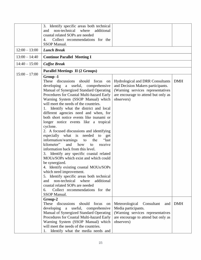
25
3. Identify specific areas both technical
and non-technical where additional
coastal related SOPs are needed
4. Collect recommendations for the
SSOP Manual.
12:00 – 13:00 Lunch Break
13:00 – 14:40 Continue Parallel Meeting I
14:40 – 15:00 Coffee Break
15:00 – 17:00 Parallel Meetings II (2 Groups)
Group -1
These discussions should focus on
developing a useful, comprehensive
Manual of Synergized Standard Operating
Procedures for Coastal Multi-hazard Early
Warning System (SSOP Manual) which
will meet the needs of the countries.
1. Identify what the district and local
different agencies need and when, for
both short notice events like tsunami or
longer notice events like a tropical
cyclone.
2. A focused discussions and identifying
especially what is needed to get
information/warnings to the “last
kilometer” and how to receive
information back from this level.
3. Identify any specific coastal related
MOUs/SOPs which exist and which could
be synergized.
4. Identify existing coastal MOUs/SOPs
which need improvement.
5. Identify specific areas both technical
and non-technical where additional
coastal related SOPs are needed
6. Collect recommendations for the
SSOP Manual.
Hydrological and DRR Consultants
and Decision Makers participants.
(Warning services representatives
are encourage to attend but only as
observers)
DMH
Group-2
These discussions should focus on
developing a useful, comprehensive
Manual of Synergized Standard Operating
Procedures for Coastal Multi-hazard Early
Warning System (SSOP Manual) which
will meet the needs of the countries.
1. Identify what the media needs and
Meteorological Consultant and
Media participants.
(Warning services representatives
are encourage to attend but only as
observers)
DMH
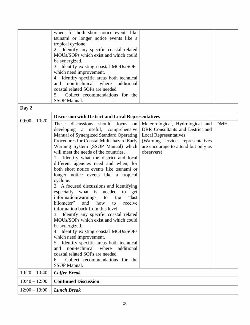
26
when, for both short notice events like
tsunami or longer notice events like a
tropical cyclone.
2. Identify any specific coastal related
MOUs/SOPs which exist and which could
be synergized.
3. Identify existing coastal MOUs/SOPs
which need improvement.
4. Identify specific areas both technical
and non-technical where additional
coastal related SOPs are needed
5. Collect recommendations for the
SSOP Manual.
Day 2
09:00 – 10:20 Discussion with District and Local Representatives
These discussions should focus on
developing a useful, comprehensive
Manual of Synergized Standard Operating
Procedures for Coastal Multi-hazard Early
Warning System (SSOP Manual) which
will meet the needs of the countries.
1. Identify what the district and local
different agencies need and when, for
both short notice events like tsunami or
longer notice events like a tropical
cyclone.
2. A focused discussions and identifying
especially what is needed to get
information/warnings to the “last
kilometer” and how to receive
information back from this level.
3. Identify any specific coastal related
MOUs/SOPs which exist and which could
be synergized.
4. Identify existing coastal MOUs/SOPs
which need improvement.
5. Identify specific areas both technical
and non-technical where additional
coastal related SOPs are needed
6. Collect recommendations for the
SSOP Manual.
Meteorological, Hydrological and
DRR Consultants and District and
Local Representatives.
(Warning services representatives
are encourage to attend but only as
observers)
DMH
10:20 – 10:40 Coffee Break
10:40 – 12:00 Continued Discussion
12:00 – 13:00 Lunch Break
27
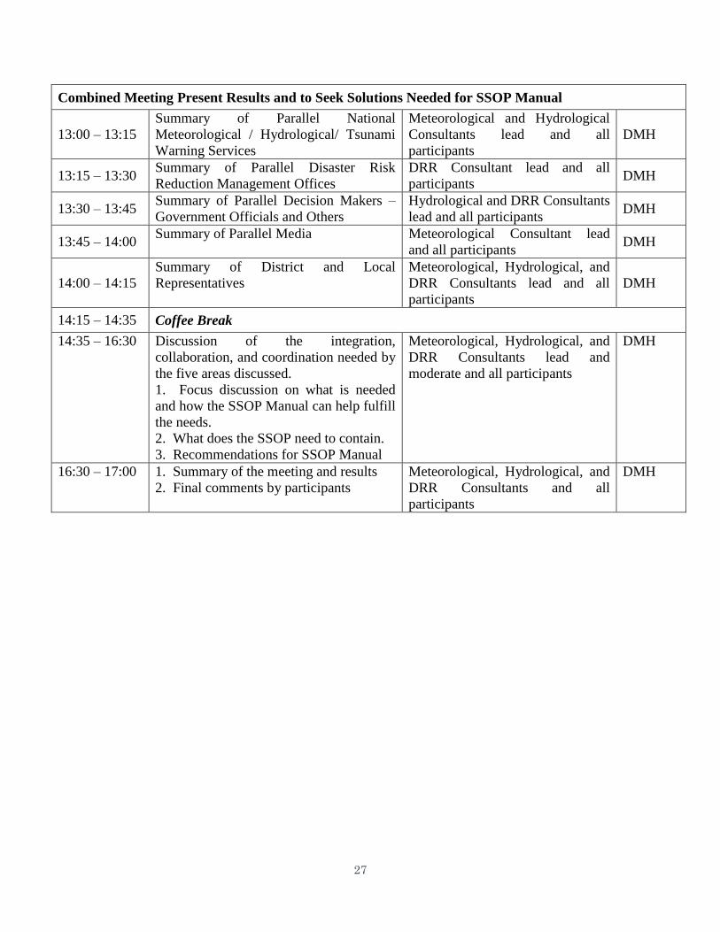
Combined Meeting Present Results and to Seek Solutions Needed for SSOP Manual
13:00 – 13:15
Summary of Parallel National
Meteorological / Hydrological/ Tsunami
Warning Services
Meteorological and Hydrological
Consultants lead and all
participants
DMH
13:15 – 13:30 Summary of Parallel Disaster Risk
Reduction Management Offices
DRR Consultant lead and all
participants DMH
13:30 – 13:45 Summary of Parallel Decision Makers –
Government Officials and Others
Hydrological and DRR Consultants
lead and all participants DMH
13:45 – 14:00 Summary of Parallel Media Meteorological Consultant lead
and all participants DMH
14:00 – 14:15
Summary of District and Local
Representatives
Meteorological, Hydrological, and
DRR Consultants lead and all
participants
DMH
14:15 – 14:35 Coffee Break
14:35 – 16:30 Discussion of the integration,
collaboration, and coordination needed by
the five areas discussed.
1. Focus discussion on what is needed
and how the SSOP Manual can help fulfill
the needs.
2. What does the SSOP need to contain.
3. Recommendations for SSOP Manual
Meteorological, Hydrological, and
DRR Consultants lead and
moderate and all participants
DMH
16:30 – 17:00 1. Summary of the meeting and results
2. Final comments by participants
Meteorological, Hydrological, and
DRR Consultants and all
participants
DMH
28
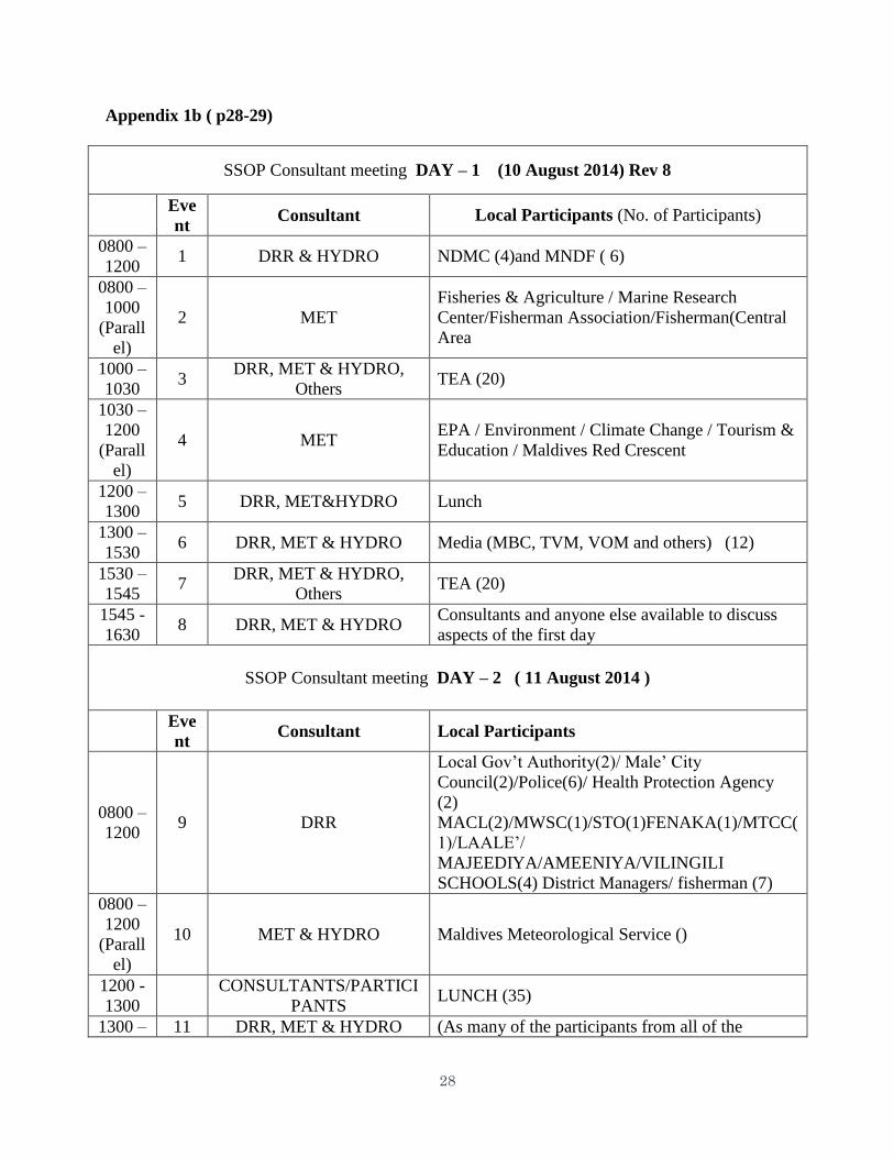
Appendix 1b ( p28-29)
SSOP Consultant meeting DAY – 1 (10 August 2014) Rev 8
Eve
nt Consultant Local Participants (No. of Participants)
0800 –
1200 1 DRR & HYDRO NDMC (4)and MNDF ( 6)
0800 –
1000
(Parall
el)
2 MET
Fisheries & Agriculture / Marine Research
Center/Fisherman Association/Fisherman(Central
Area
1000 –
1030 3
DRR, MET & HYDRO,
Others TEA (20)
1030 –
1200
(Parall
el)
4 MET EPA / Environment / Climate Change / Tourism &
Education / Maldives Red Crescent
1200 –
1300 5 DRR, MET&HYDRO Lunch
1300 –
1530 6 DRR, MET & HYDRO Media (MBC, TVM, VOM and others) (12)
1530 –
1545 7
DRR, MET & HYDRO,
Others TEA (20)
1545 -
1630 8 DRR, MET & HYDRO
Consultants and anyone else available to discuss
aspects of the first day
SSOP Consultant meeting DAY – 2 ( 11 August 2014 )
Eve
nt Consultant Local Participants
0800 –
1200 9 DRR
Local Gov’t Authority(2)/ Male’ City
Council(2)/Police(6)/ Health Protection Agency
(2)
MACL(2)/MWSC(1)/STO(1)FENAKA(1)/MTCC(
1)/LAALE’/
MAJEEDIYA/AMEENIYA/VILINGILI
SCHOOLS(4) District Managers/ fisherman (7)
0800 –
1200
(Parall
el)
10 MET & HYDRO Maldives Meteorological Service ()
1200 -
1300
CONSULTANTS/PARTICI
PANTS LUNCH (35)
1300 – 11 DRR, MET & HYDRO (As many of the participants from all of the
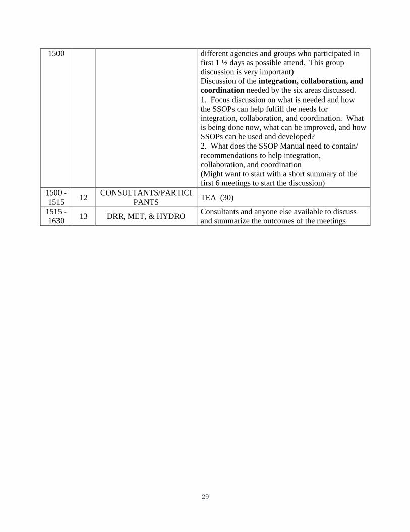
29
1500 different agencies and groups who participated in
first 1 ½ days as possible attend. This group
discussion is very important)
Discussion of the integration, collaboration, and
coordination needed by the six areas discussed.
1. Focus discussion on what is needed and how
the SSOPs can help fulfill the needs for
integration, collaboration, and coordination. What
is being done now, what can be improved, and how
SSOPs can be used and developed?
2. What does the SSOP Manual need to contain/
recommendations to help integration,
collaboration, and coordination
(Might want to start with a short summary of the
first 6 meetings to start the discussion)
1500 -
1515 12
CONSULTANTS/PARTICI
PANTS TEA (30)
1515 -
1630 13 DRR, MET, & HYDRO
Consultants and anyone else available to discuss
and summarize the outcomes of the meetings
30
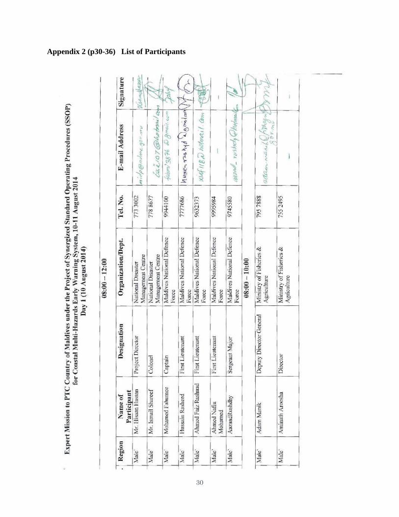
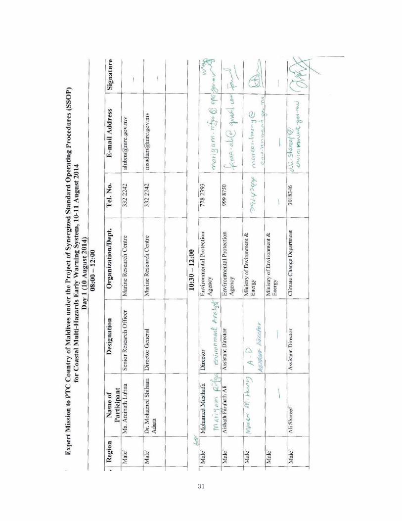
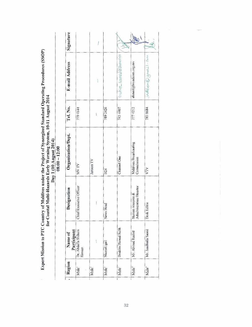
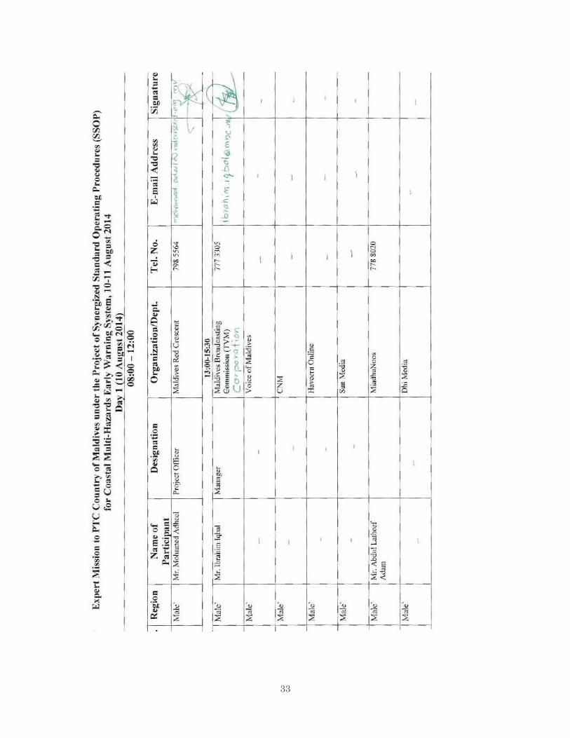
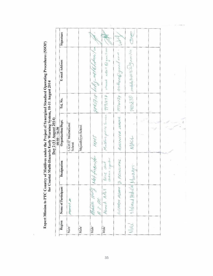
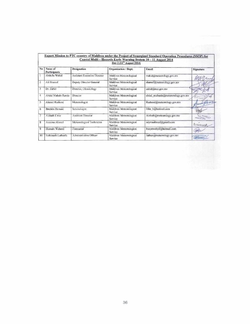
Appendix 2 (p30-36) List of Participants
31
32
33

34
\
35
36
37
Appendix 3
Geographical map of Maldives
38
Appendix 4a
Frequency of Depression/Cyclonic Storm/Severe cyclonic storms over 2.5°x2.5° square in
the region 50 °E-100°E, 5°N-35°N
Appendix 4b
Tracks of Depressions/CS/SCS which originated in the Maldives area
39
Appendix 5 (page 39-40)
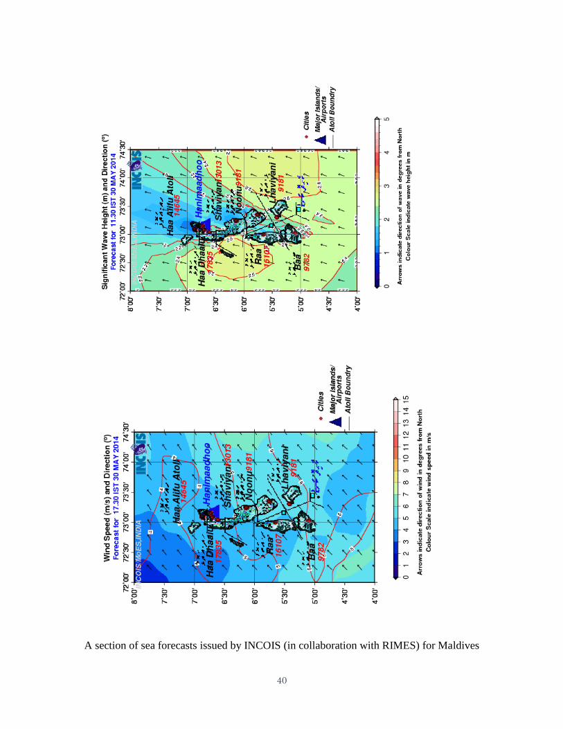
40
A section of sea forecasts issued by INCOIS (in collaboration with RIMES) for Maldives
41
Appendix 6 (page 41-42)
42
43
Appendix 7
44
Appendix 8 (page 44-47)
45
46
47
48
Appendix 9 (page 48-50)
49
50
51
Appendix 10
52
Appendix 11
Headings and sub headings of SOP of the NMHEWC of MMS
Chapter-1
a. Purpose
b. Role and Mission
c. Products and Capacity
d. Assignment of responsibilities
1. Duties of Geological observers
2. Duties of Meteorological Observers
3. Duties of Meteorological Forecasters
4. Responsibilities of Taskforce team
5. Responsibilities of the Emergency Operation Heads (EOHs)
Sample Daily check list for Geological Observers
Check list for EQ event
Chapter-2
Operation and maintenance of seismic and sea level observation network.
a. Specification
b. Data transmission / communication procedure / routes
c. Station management procedure
Daily checklist for Technical support unit
Chapter – 3
Event alarm operational procedures and criteria for tsunamigenic earthquake and weather
hazards
1. Criteria for alert and warnings for the earthquake, Tsunamis
2. Criteria for issuing weather advisories and warnings
Weather advisories and warnings flow chart
National alert and warning flow chart on natural disasters
States of activities – various levels of emergency
Warning dissemination flow charts for stages 1 to 4
Warning / information time line
Chapter – 4
NTWC General process and flow charts for Earthquake and Tsunami
53
Appendix 12 (Page 53-54)
Meeting With MMS and Armed Forces Official
Meeting with NGOs, Media, Fishermen, Maldives Red Crescent
54
Photo With DG MMS, State Minister and Deputy Minister
Group Photo With MMS and Other Department Officials
55
Appendix 13 (page 55-56)
Table -1
Safe Islands from P hysical Vulnerability Risk
S. No. ISLAND ATOLL
MULTI
HAZARD PHYSICAL RISK
INDEX
1 MALE KAAFU 5
2 FOAMMULAH GNAVIYANI 5
3 KULHUDUFFUSHI HAA DHAALU 5
4 HULHUDHOO SEENU 5
5 DHIDHDHOO HAA ALIFU 5
6 DHIDHDHOO ALIFU
DHAALU
5
7 KELAA HAA ALIFU 5
8 NOLHIVARAMU HAA DHAALU 5
9 GADHDHOO GAAFU
DHAALU
5
10 NAIFARU LHAVIYANI 5
11 THODDOO ALIFU ALIFU 5
12 EYDHAFUSHI BAA 5
13 KALHAIDHOO LAAMU 5
56
S.NO.
ISLAND
ATOLL
MULTI HAZARD
PHYSICAL RISK INDEX
1 BODUFOLHUDHOO ALIFU ALIFU 1
2 HIMENDHOO ALIFU ALIFU 1
3 MAALHOSS ALIFU ALIFU 1
4 MATHIVERI ALIFU ALIFU 1
5 UKULHAS ALIFU ALIFU 1
6 MANDHOO ALIFU DHAALU 1
7 DHONFANU
B
A
A
1
8 KIHAADHOO
B
A
A
1
9 KUDARIKILU
B
A
A
1
10 HULHUDHELI DHAALU 1
11 MEEDHOO DHAALU 1
12 RIBUDHOO DHAALU 1
13 DHARANBOODHOO FAAFU 1
14 MAGOODHOO FAAFU 1
15 THINADHOO GAAFU DHAALU 1
16 FODHDHOO NOONU 1
17 KANDOODHOO THAA 1
18 OMADHOO THAA 1
19 VANDHOO THAA 1
20 RAKEEDHOO VAAVU 1
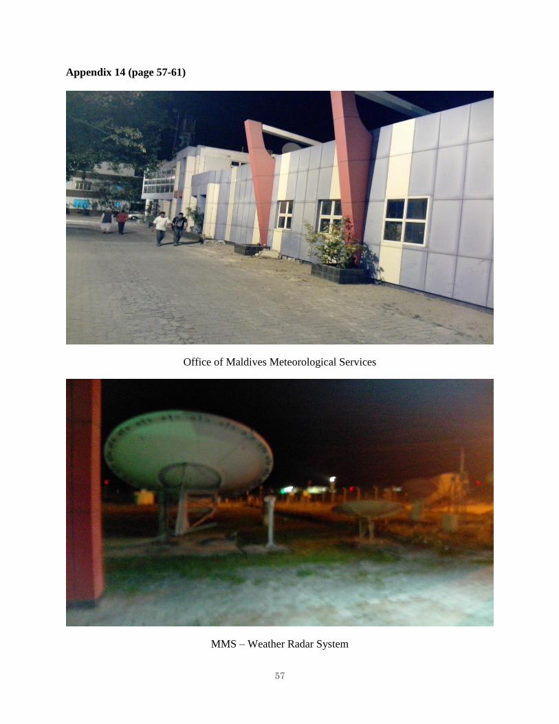
57
Appendix 14 (page 57-61)
Office of Maldives Meteorological Services
MMS – Weather Radar System
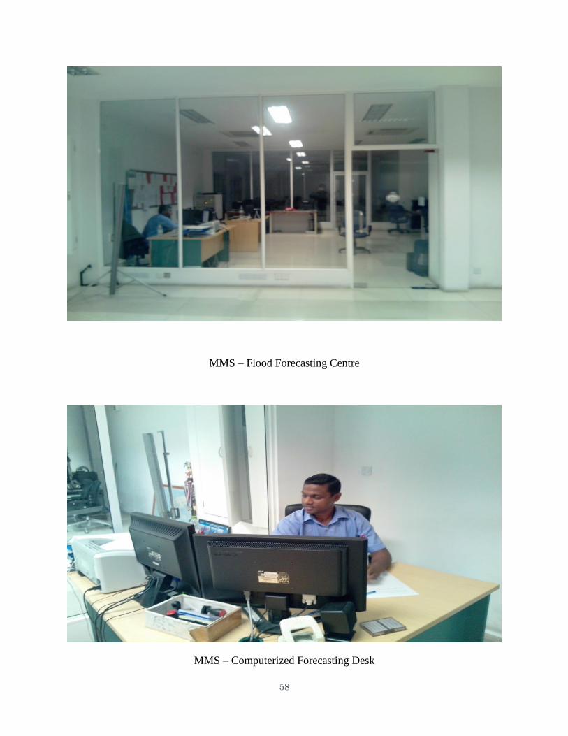
58
MMS – Flood Forecasting Centre
MMS – Computerized Forecasting Desk
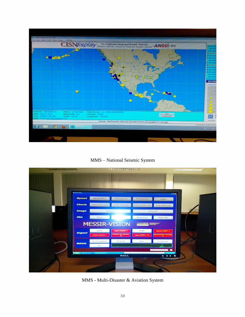
59
MMS – National Seismic System
MMS - Multi-Disaster & Aviation System
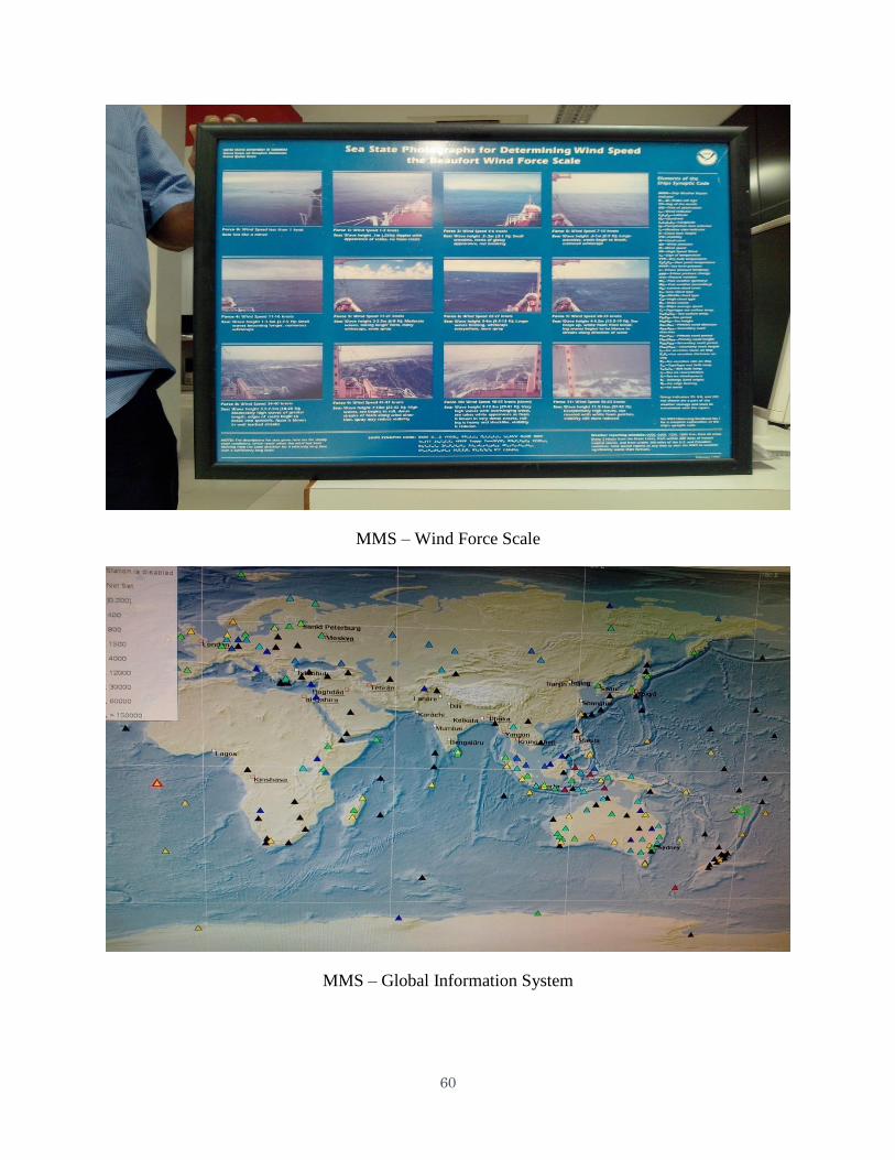
60
MMS – Wind Force Scale
MMS – Global Information System
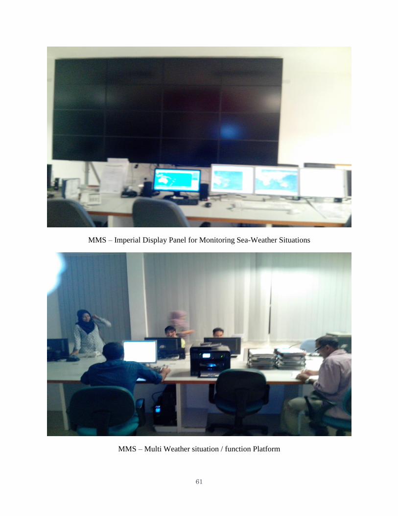
61
MMS – Imperial Display Panel for Monitoring Sea-Weather Situations
MMS – Multi Weather situation / function Platform


