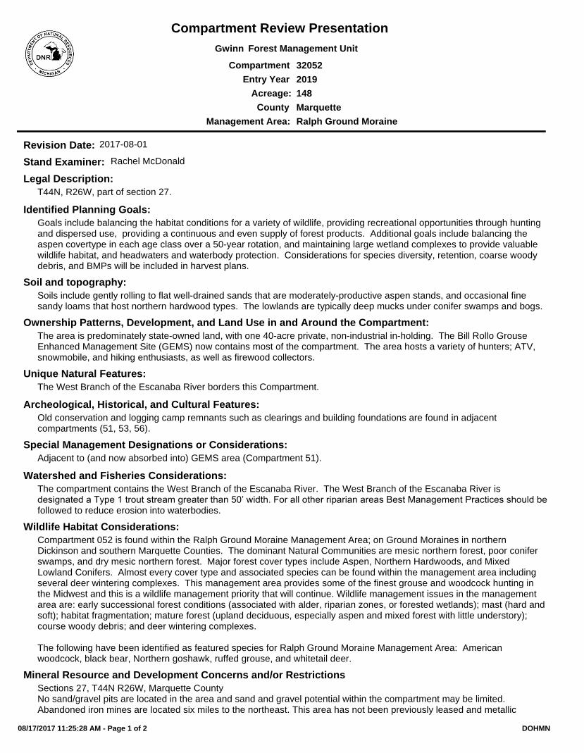
County
Acreage:
Entry Year
Compartment
Compartment Review Presentation
Forest Management UnitGwinn
32052
2019
148
Marquette
Management Area: Ralph Ground Moraine
Legal Description:
Identified Planning Goals:
Soil and topography:
Ownership Patterns, Development, and Land Use in and Around the Compartment:
Unique Natural Features:
Archeological, Historical, and Cultural Features:
Special Management Designations or Considerations:
Watershed and Fisheries Considerations:
Wildlife Habitat Considerations:
Mineral Resource and Development Concerns and/or Restrictions
T44N, R26W, part of section 27.
Goals include balancing the habitat conditions for a variety of wildlife, providing recreational opportunities through hunting and dispersed use, providing a continuous and even supply of forest products. Additional goals include balancing the aspen covertype in each age class over a 50-year rotation, and maintaining large wetland complexes to provide valuable wildlife habitat, and headwaters and waterbody protection. Considerations for species diversity, retention, coarse woody debris, and BMPs will be included in harvest plans.
Soils include gently rolling to flat well-drained sands that are moderately-productive aspen stands, and occasional fine sandy loams that host northern hardwood types. The lowlands are typically deep mucks under conifer swamps and bogs.
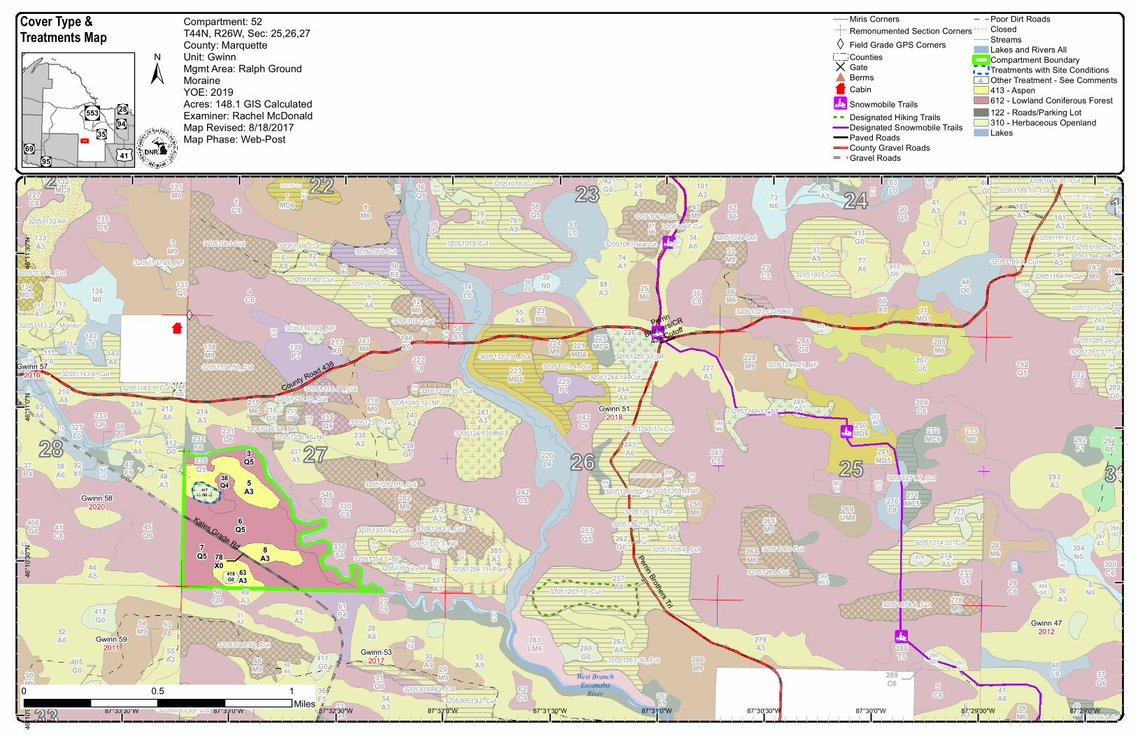
The area is predominately state-owned land, with one 40-acre private, non-industrial in-holding. The Bill Rollo Grouse Enhanced Management Site (GEMS) now contains most of the compartment. The area hosts a variety of hunters; ATV, snowmobile, and hiking enthusiasts, as well as firewood collectors.
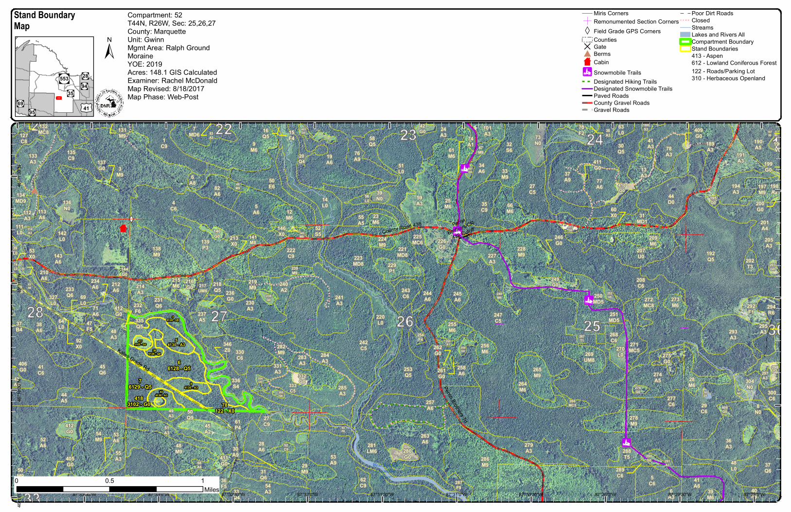
The West Branch of the Escanaba River borders this Compartment.
Old conservation and logging camp remnants such as clearings and building foundations are found in adjacent compartments (51, 53, 56).
Adjacent to (and now absorbed into) GEMS area (Compartment 51).
The compartment contains the West Branch of the Escanaba River. The West Branch of the Escanaba River is designated a Type 1 trout stream greater than 50’ width. For all other riparian areas Best Management Practices should be followed to reduce erosion into waterbodies.
Compartment 052 is found within the Ralph Ground Moraine Management Area; on Ground Moraines in northern Dickinson and southern Marquette Counties. The dominant Natural Communities are mesic northern forest, poor conifer swamps, and dry mesic northern forest. Major forest cover types include Aspen, Northern Hardwoods, and Mixed Lowland Conifers. Almost every cover type and associated species can be found within the management area including several deer wintering complexes. This management area provides some of the finest grouse and woodcock hunting in the Midwest and this is a wildlife management priority that will continue. Wildlife management issues in the management area are: early successional forest conditions (associated with alder, riparian zones, or forested wetlands); mast (hard and soft); habitat fragmentation; mature forest (upland deciduous, especially aspen and mixed forest with little understory); course woody debris; and deer wintering complexes.
The following have been identified as featured species for Ralph Ground Moraine Management Area: American woodcock, black bear, Northern goshawk, ruffed grouse, and whitetail deer.
Sections 27, T44N R26W, Marquette CountyNo sand/gravel pits are located in the area and sand and gravel potential within the compartment may be limited. Abandoned iron mines are located six miles to the northeast. This area has not been previously leased and metallic
Revision Date: 2017-08-01
Stand Examiner: Rachel McDonald
08/17/2017 11:25:28 AM - Page 1 of 2 DOHMN

Vehicle Access:
Survey Needs:
Recreational Facilities and Opportunities:
Fire Protection:
Additional Compartment Information:
mineral potential appears to be low at this time. There is no economic oil and gas production in the UP.
Vehicle access is good from County Road 438 which is maintained year-round, and seasonal from Kate's Grade heading north.
None at this time.
The area hosts a variety of hunters; ATV, snowmobile, and hiking enthusiasts, as well as firewood collectors. Access to the Compartment is good from County Road 438 and Kate's Grade.
Fire protection is within the Gwinn Management Unit of fire protection. Dominated by aspen, hardwood, and conifer lowlands, this is not a very fire-prone landscape. Access to the Compartment is good from County Road 438 and Kate's Grade.
The following reports from the Inventory are attached:
Total Acres by Cover Type and Age Class
Cover Type by Harvest Method
Proposed Treatments – No Limiting Factors
Proposed Treatments – With Limiting Factors
Stand Details (Forested and Nonforested)
Dedicated and Proposed Special Conservation Areas
Site Condition Details
The following information is displayed, where pertinent, on the attached compartment maps:
Base feature information, stand boundaries, cover types, and numbers
Proposed treatments
Site condition boundaries
Details on the road access system
08/17/2017 11:25:28 AM - Page 2 of 2 DOHMN
West BranchEscanaba
River
Kates Grade Rd
County Road 438
PerrinBrothers/CR
438 Cutoff
Perrin Brothers Trl267T1
332G0
34A6
291A3
51A6
31Q6
142L0
51A3
197M9
285A3
37A9
42G0
275G0
283A3
14L0
251MD5
229P1
134MD9
224M9
48A3
407G0
54A3
13A3
51L0
330C6
221MD8
410G0
63L0
264M6
43A6 287
F9
23M6
48L0
218Q5
28M6
245A6
304N0
3M9
196V0
63F6
294R6
219M9
286M9
76A9
66M6
20Q4
255M6
136N0
39L0
271MC5
217UM6
54M9
336S4
228M9
242C5
249G0
256M6
43C6
32S6
29M9
354U0
49A3
212A6
40F5
64L0
9M6
52S5
6A3
144G0
277C6
413G0
190A5
227A3
260A1
298G0
49M9
143A6
46A3
6A8
232F6
113A6
37Q6
61M6
238G0
15F4
220L0
133A3
274A5
225MC6
280G0
266MC5
270L0
202T3
55A3
279A3
282M9
355G0
27C5
58Q5
35C9
331A3
47M9 78
A3
12M6
210A6
207U0
135C9
52C9
253Q5
209M6
292F1
194A3
55A5
52A6
29C6
188S2
284A3
6N0
191A3
38A6
44A5 257
A6
288T5
44D0
1C9
61P4
250MD5
68A6
31MD1
41A3
240A2
41C6 297
A3
24A3
254F4
230A3
233Q6
139P3
272MC8
4C6
300C6
215M6
223MD8
269UM8
30Q5
333C5
259G0
408G0
33Q4
47F5
74L0
7MD6
231Q6
53A9
263A6
50E6
145M9
127C8
50M9
33M9
241A3
70F2
82A6
50Q9
73N0
71A6
27C9
208C6
138M9
41A6
239M9
62C9
59A3
276G0
114A3
411G0
19A6
244A6
45A2
243C6 273
M6
201A4
56L0
293A3
39N0
412G0
140G0
403G0
50Z0
247C5
189A3
278M9
258A6
237A5
77A6
265M9
222C9
226G0
295A3
248M6
42A3
25M6
203G0
28A6 281
LM6
214A3
36A3
5A6
252V0
101A3
195G0
268C6
192Q5
216G0
45Q6
48M9
290G0
39M6
327L0
141M8
63A6
5C6
112A3
5X0
92X0
261G0
198A2
37Q9
187X0
137G0
262G0
60X0
37B4
111L0
236G069
L0
200G0
289C6
205A3
83A3
53X0
405G0
9L0
38A3
335Q5
74A1
411G0
1Z0
246G0
30A9
199G0
80A3
406G0
131M9
53A6
234A6
16Q5
36F5
132MC8
213X0
346Z0
412G0
146X0
409G0
8N0
32051134.2_Cut32051137.26_NF
32051284.11_Plant
32051216.64_NF
32051354.5_NF
32051226.33_NF
32051260.22_NF
32051261.21_NF
32051246.27_NF
32051332.3_NF
32051355.2_NF
32051140.28_NF
32051236.46_NF
32051262.13_NF
32053048.52_Cut
32051278.4_Cut
32053043.49_Cut
32053030.43_Cut32053053.42_Cut
32051241.35_NF
32047040.4_Cut
32051007-Cut
32051037-Cut
32051076-Cut
32051019-Cut
32051082-Cut 32051005-Cut
32051012-Cut
32051050-Cut32051003-Cut 32051006-Cut
32051061-Cut32051047-Cut
32051033-Cut
32051143.6_Cut32051143.5_Cut
32051046.27_Cut
32051205.2_Cut
32051201-Cut
32051189.10_Cut
32051194.7_Cut
32051190.16_Cut
32051191.6_Cut32051190.5_Cut
32051189.4_Cut
32051201.31_Cut
32051198.29_Cut
32051113.25_Monitor
32051239.38_Cut32051244.19_Cut
32051257.15_Cut
32051282.10_Cut
32051138.50_Cut
32051218.44_Cut32051217.15_Cut
32051255.11_Cut
32051223.39_Cut
32051240.12_NF
32051238.11_NF
32051259.9_NF
32051249.13_NF
32051263.30_Cut
32051271.7_Cut
32051258.6_Cut
32051245.11_Cut
32051221.4_Cut
32051283.2_Cut32051331.42_Cut32051274.32_Cut
32051265-Cut
32051264-Cut
32051027-CutSBW
32051061clearcut
32051133-NF
78X0
8A3
5A3
6Q5
63A3
417G0
38Q4
7Q5
3Q5
418G0
Gwinn 472012
Gwinn 512018
Gwinn 532017
Gwinn 572016
Gwinn 582020
Gwinn 592011
87°29'0"W87°29'30"W87°30'0"W87°30'30"W87°31'0"W87°31'30"W87°32'0"W87°32'30"W87°33'0"W87°33'30"W
46°11
'30"N
46°11
'0"N
46°1
0'30"N
46°1
0'0"N
0 10.5Miles
Miris CornersÓ Remonumented Section CornersXW Field Grade GPS Corners
CountiesD Gate# Berms× Cabin!. Snowmobile Trails
Designated Hiking TrailsDesignated Snowmobile TrailsPaved RoadsCounty Gravel RoadsGravel Roads
Poor Dirt RoadsClosedStreamsLakes and Rivers AllCompartment BoundaryTreatments with Site ConditionsOther Treatment - See Comments413 - Aspen612 - Lowland Coniferous Forest122 - Roads/Parking Lot310 - Herbaceous OpenlandLakes"!(94"!(553
"!(69"!(35
"!(95
"!(28
£¤41
±
Cover Type &Treatments Map
Compartment: 52T44N, R26W, Sec: 25,26,27County: MarquetteUnit: GwinnMgmt Area: Ralph GroundMoraineYOE: 2019Acres: 148.1 GIS CalculatedExaminer: Rachel McDonaldMap Revised: 8/18/2017Map Phase: Web-Post
West BranchEscanaba
River
Kates Grade Rd
County Road 438 PerrinBrothers/CR
438 Cutoff
Perrin Brothers Trl267T1
332G0
34A6
291A3
51A6
31Q6
142L0
51A3
197M9
285A3
37A9
42G0
275G0283
A3
14L0
251MD5
229P1
134MD9
224M9
48A3
407G0
54A3
13A3
51L0
330C6
221MD8
410G0
63L0
264M6
43A6
287F9
23M6
48L0
218Q5
28M6
245A6
304N0
3M9
196V0
63F6
294R6
219M9
286M9
76A9
66M6
20Q4
255M6
136N0
39L0
271MC5
217UM6
54M9
336S4
228M9
242C5
249G0
256M6
43C6
32S6
29M9
354U0
49A3
212A6
40F5
64L0
9M6
52S5
6A3
144G0
277C6
413G0
190A5
227A3
260A1
298G0
49M9
143A6
46A3
6A8
232F6
113A6
37Q6
61M6
238G0
220L0
133A3
274A5
225MC6
280G0
266MC5
270L0
202T3
55A3
279A3
282M9
355G0
27C5
58Q5
35C9
331A3
47M9 78
A3
12M6
210A6
207U0
135C9
52C9
253Q5
209M6
292F1
194A3
55A5
52A6
29C6
188S2
284A3
6N0
191A3
38A6
44A5 257
A6
288T5
44D0
1C9
61P4
250MD5
68A6
31MD1
41A3
240A2
41C6 297
A3
24A3
254F4
230A3
233Q6
139P3
272MC8
4C6
300C6
215M6
223MD8
269UM8
30Q5
333C5
259G0
408G0
33Q4
47F5
74L0
7MD6
231Q6
53A9
263A6
50E6
145M9
127C8
50M9
33M9
241A3
70F2
82A6
50Q9
73N0
71A6
27C9
208C6
138M9
41A6
239M9
62C9
59A3
276G0
114A3
411G0
19A6
244A6
45A2
243C6 273
M6
201A4
56L0
293A3
39N0
412G0
140G0
403G0
50Z0
247C5
189A3
278M9
258A6
237A5
77A6
265M9
222C9
226G0
248M6
42A3
25M6
203G0
28A6 281
LM6
214A3
36A3
5A6
252V0
101A3
195G0
268C6
192Q5
216G0
45Q6
48M9
290G0
39M6
327L0
141M8
63A6
5C6
78122 - X0
4183102 - G0
84130 - A3
54130 - A3
66128 - Q5
634130 - A3
4173105 - G0
386124 - Q4
76129 - Q5
36124 - Q5
112A3
5X0
92X0
261G0
198A2
37Q9
187X0
137G0
262G0
60X0
37B4
111L0
236G069
L0
200G0
289C6
205A3
83A3
53X0
405G0
9L0
15F4
38A3
335Q5
74A1
411G0
1Z0
246G0
30A9
199G0
406G0
131M9
53A6
234A6
16Q5
36F5
132MC8
213X0
346Z0
412G0
295A3
146X0
409G0
8N0
87°29'0"W87°29'30"W87°30'0"W87°30'30"W87°31'0"W87°31'30"W87°32'0"W87°32'30"W87°33'0"W87°33'30"W
46°11
'30"N
46°11
'0"N
46°1
0'30"N
46°1
0'0"N
0 10.5Miles
Miris CornersÓ Remonumented Section CornersXW Field Grade GPS Corners
CountiesD Gate# Berms× Cabin!. Snowmobile Trails
Designated Hiking TrailsDesignated Snowmobile TrailsPaved RoadsCounty Gravel RoadsGravel Roads
Poor Dirt RoadsClosedStreamsLakes and Rivers AllCompartment BoundaryStand Boundaries413 - Aspen612 - Lowland Coniferous Forest122 - Roads/Parking Lot310 - Herbaceous Openland
"!(94"!(553
"!(69"!(35
"!(95
"!(28
£¤41
±
Stand BoundaryMap
Compartment: 52T44N, R26W, Sec: 25,26,27County: MarquetteUnit: GwinnMgmt Area: Ralph GroundMoraineYOE: 2019Acres: 148.1 GIS CalculatedExaminer: Rachel McDonaldMap Revised: 8/18/2017Map Phase: Web-Post

3J - 22
West BranchEscanaba
River
Kates Grade Rd
County Road 438 PerrinBrothers/CR
438 Cutoff
Perrin Brothers Trl
5F - 63
5C - 53
5F - 5
5F - 1
2I - 142I - 19
5F - 7
5F - 1
5F - 2
5F - 5
2I - 18
5C - 51
2E - 3
5F - 3
5C - 71
2G - 58
3J - 4
3J - 22
2G - 31
2G - 62G - 6
2G - 16
2H - 43
3L - 4
3H - 10
2F - 53
3L - 11
2G - 33
2G - 45
3J - 52
1C - 43
2H - 55
2G - 16
2G - 69
1C - 6
2G - 65
3H - 11
3H - 113H - 11
1C - 35
3I - 47
2G - 8
1C - 2
2G - 42
2G - 54
3J - 633J - 272G - 50
1C - 7
3J - 15
2F - 61
2G - 37
3J - 16
2G - 1
3J - 20
267T1
332G0
34A6
291A3
51A6
31Q6
142L0
51A3
197M9
285A3
37A9
42G0
275G0283
A3
14L0
251MD5
229P1
134MD9
224M9
48A3
407G0
54A3
13A3
51L0
330C6
221MD8
410G0
63L0
264M6
43A6
287F9
23M6
48L0
218Q5
28M6
245A6
304N0
3M9
196V0
294R6
219M9
286M9
76A9
66M6
20Q4
255M6
136N0
39L0
271MC5
217UM6
54M9
336S4
228M9
242C5
249G0
256M6
43C6
32S6
29M9
354U0
49A3
212A6
40F5
64L0
9M6
52S5
6A3
144G0
277C6
413G0
190A5
227A3
260A1
298G0
49M9
143A6
46A3
6A8
232F6
113A6
37Q6
61M6
238G0
220L0
133A3
274A5
225MC6
280G0
266MC5
270L0
202T3
55A3
279A3
282M9
355G0
27C5
58Q5
35C9
331A3
47M9 78
A3
12M6
210A6
207U0
135C9
52C9
253Q5
209M6
292F1
194A3
55A5
52A6
29C6
188S2
284A3
6N0
191A3
38A6
44A5 257
A6
288T5
44D0
1C9
61P4
250MD5
68A6
31MD1
41A3
240A2
41C6 297
A3
24A3
254F4
230A3
233Q6
139P3
272MC8
4C6
300C6
215M6
223MD8
269UM8
30Q5
333C5
259G0
408G0
33Q4
47F5
74L0
7MD6
231Q6
53A9
263A6
50E6
145M9
127C8
50M9
33M9
241A3
70F2
82A6
50Q9
73N0
71A6
27C9
208C6
138M9
41A6
239M9
62C9
59A3
276G0
114A3
411G0
19A6
244A6
45A2
243C6
273M6
201A4
56L0
293A3
39N0
412G0
140G0
403G0
50Z0
247C5
189A3
278M9
258A6
237A5
77A6
265M9
222C9
226G0
248M6
42A3
25M6
203G0
28A6
281LM6
214A3
36A3
5A6
252V0
101A3
195G0
268C6
192Q5
216G0
45Q6
48M9
290G0
39M6
327L0
141M8
63A6
5C6
112A3
5X0
92X0
261G0
198A2
37Q9
187X0
137G0
262G0
60X0
63F6
37B4
111L0
236G069
L0
200G0
289C6
205A3
83A3
53X0
405G0
9L0
15F4
38A3
335Q5
74A1
411G0
1Z0
246G0
30A9
199G0
406G0
131M9
53A6
234A6
16Q5
36F5
132MC8
213X0
346Z0
412G0
295A3
146X0
409G0
8N0
84130 - A3
54130 - A3
66128 - Q5
634130 - A3
4173105 - G0
386124 - Q4
76129 - Q5
36124 - Q5
78122 - X0
4183102 - G0
2G - 16 2G - 13
2G - 2
2G - 3
2G - 46
2H - 473J - 11 3J - 15A - 65
5A - 36
5E - 19
2H - 5
3J - 4
3J - 4
3J - 103J - 6
3J - 12
3J - 8
3J - 8
87°29'0"W87°29'30"W87°30'0"W87°30'30"W87°31'0"W87°31'30"W87°32'0"W87°32'30"W87°33'0"W87°33'30"W
46°11
'30"N
46°11
'0"N
46°1
0'30"N
46°1
0'0"N
0 10.5Miles
Miris CornersÓ Remonumented Section CornersXW Field Grade GPS Corners
CountiesD Gate# Berms× Cabin!. Snowmobile Trails
Designated Hiking TrailsDesignated Snowmobile TrailsPaved RoadsCounty Gravel RoadsGravel Roads
Poor Dirt RoadsClosedStreamsLakes and Rivers AllCompartment Boundary
\\ Unavailable
2G: Too wet (sensitive soils, does notinclude access issues)2H: Blocked by physical obstacle (e.g.upland stand in a lowland area)3J: Water quality / BMPs (stream, river, orlake)5A: Not able to obtain desirableregeneration5E: Long-Term Retention
Stand BoundariesCold Water StreamsCold Water LakesHigh Priority Trout Stream BufferHabitat CorridorOther Habitat Area
"!(94"!(553
"!(69"!(35
"!(95
"!(28
£¤41
±
Special Conservation Areas& Site Conditions Map
Compartment: 52T44N, R26W, Sec: 25,26,27County: MarquetteUnit: GwinnMgmt Area: Ralph GroundMoraineYOE: 2019Acres: 148.1 GIS CalculatedExaminer: Rachel McDonaldMap Revised: 8/18/2017Map Phase: Web-Post
Report 1 – Total Acres by Cover Type and Age ClassCompartmentMgt. Unit
10-1
9
20-2
9
30-3
9
40-4
9
50-5
9
60-6
9
70-7
9
80-8
9
Tot
al
Year of Entry
Age Class
90-9
9
100-
109
110-
119
0-9
: Examiner
Non-
For
est
120-
129
130-
139
140-
149
150+
Unev
en-A
ged
Gwinn
Rachel McDonald
52 2019
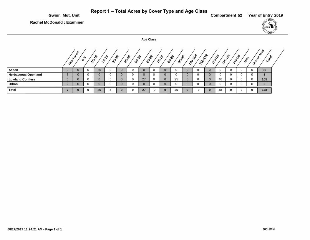
0 0 36000000003600 0 0 0 0 0Aspen
5 0 500000000000 0 0 0 0 0Herbaceous Openland
0 0 1050250027005000 0 48 0 0 0Lowland Conifers
2 0 200000000000 0 0 0 0 0Urban
0007 1480250270050 360 0 4800Total
08/17/2017 11:24:21 AM - Page 1 of 1 DOHMN
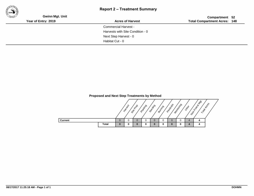
Report 2 – Treatment Summary
CompartmentMgt. Unit
Total Compartment Acres:Acres of HarvestYear of Entry:
Gwinn
2019
52
148
Commercial Harvest -
Habitat Cut - 0
Harvests with Site Condition - 0
Next Step Harvest - 0
Proposed and Next Step Treatments by Method
Tot
al A
cres
Oth
er
Non
-For
est
Mgt
.
Mon
itorin
g
Pes
ticid
e
Bur
ning
See
ding
Pla
ntin
g
Site
Pre
p
Har
vest
000 4400000Current
000 44000Total 00
08/17/2017 11:25:18 AM - Page 1 of 1 DOHMN
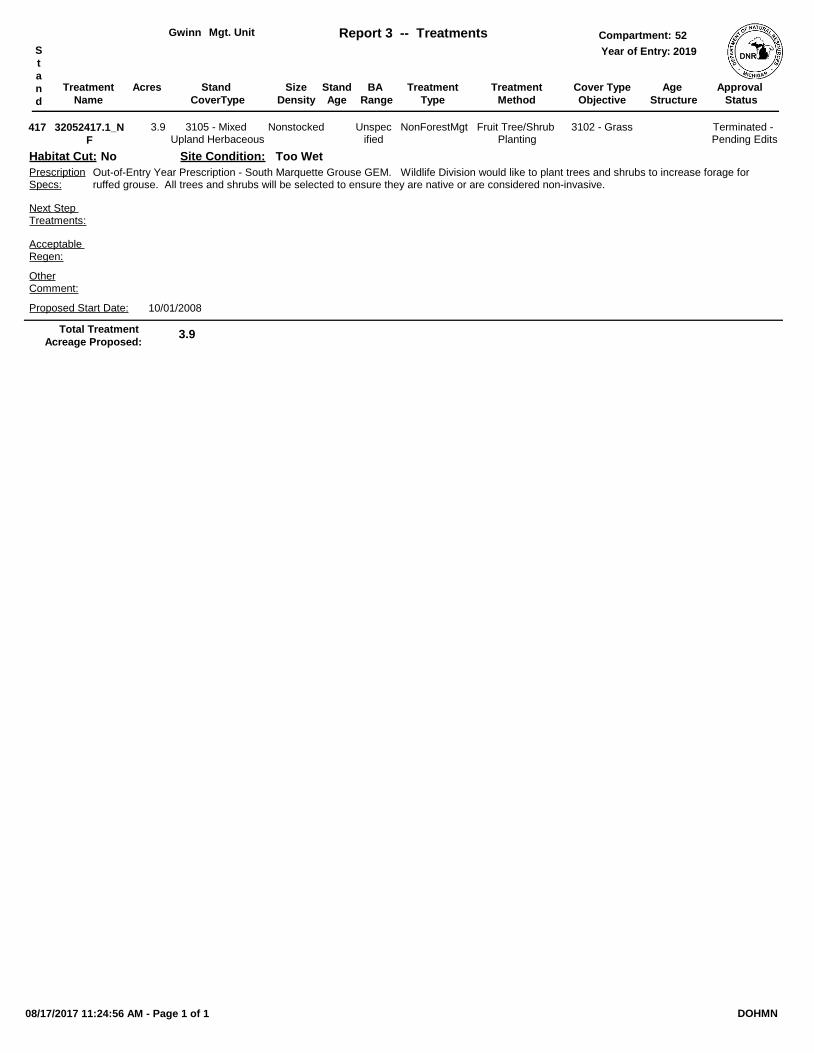
Treatment
Name
Acres Stand
Age
Cover Type
Objective
Size
Density
Treatment
Type
Treatment
Method
Stand
CoverType
Mgt. Unit Report 3 -- Treatments Compartment:
Year of Entry:S
t
a
n
d
Approval
Status
BA
Range
Gwinn 52
2019
Age
Structure
32052417.1_N
F
Nonstocked 3102 - GrassNonForestMgt Fruit Tree/Shrub Planting
Out-of-Entry Year Prescription - South Marquette Grouse GEM. Wildlife Division would like to plant trees and shrubs to increase forage for ruffed grouse. All trees and shrubs will be selected to ensure they are native or are considered non-invasive.
OtherComment:
PrescriptionSpecs:
417 3105 - Mixed Upland Herbaceous
Acceptable Regen:
Site Condition: Too Wet
Terminated - Pending Edits
Unspecified
Proposed Start Date: 10/01/2008
3.9
Next Step Treatments:
Habitat Cut: No
3.9Total Treatment
Acreage Proposed:
08/17/2017 11:24:56 AM - Page 1 of 1 DOHMN
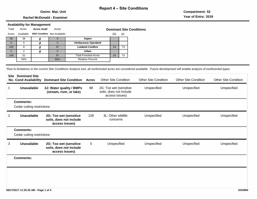
Report 4 – Site ConditionsCompartment:Mgt. Unit
Year of Entry:: Examiner
Gwinn
Rachel McDonald
52
2019
*Due to limitations in the current Site Conditions Analysis tool, all nonforested acres are considered available. Future development will enable analysis of nonforested types.
Dominant Site Condition Acres
Site
No. Other Site Condition Other Site Condition Other Site Condition Other Site ConditionDominant Site
Cond Availability
1 3J: Water quality / BMPs
(stream, river, or lake)
2G: Too wet (sensitive soils, does not include
access issues)
98
Cedar cutting restrictions
Unspecified Unspecified Unspecified
Comments:
Unavailable
2 2G: Too wet (sensitive
soils, does not include
access issues)
3L: Other wildlife concerns
128
Cedar cutting restrictions
Unspecified Unspecified Unspecified
Comments:
Unavailable
3 2G: Too wet (sensitive
soils, does not include
access issues)
Unspecified5 Unspecified Unspecified Unspecified
Comments:
Unavailable
2G
Dominant Site Conditions
3J
Aspen
Herbaceous Openland
Lowland Conifers 24 73
Urban
24 73Total Forested Acres
Relative Percent
Availability for Management
Acres Acres AvailTotal
Available With ConditionAcres
Acres
Not Available
36 036 0
5 05 0
8 0105 97
2 02 0
51148
34%
97
66%
08/17/2017 11:25:25 AM - Page 1 of 4 DOHMN
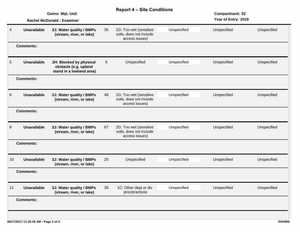
Report 4 – Site ConditionsCompartment:Mgt. Unit
Year of Entry:: Examiner
Gwinn
Rachel McDonald
52
2019
4 3J: Water quality / BMPs
(stream, river, or lake)
2G: Too wet (sensitive soils, does not include
access issues)
35 Unspecified Unspecified Unspecified
Comments:
Unavailable
5 2H: Blocked by physical
obstacle (e.g. upland
stand in a lowland area)
Unspecified6 Unspecified Unspecified Unspecified
Comments:
Unavailable
6 3J: Water quality / BMPs
(stream, river, or lake)
2G: Too wet (sensitive soils, does not include
access issues)
48 Unspecified Unspecified Unspecified
Comments:
Unavailable
8 3J: Water quality / BMPs
(stream, river, or lake)
2G: Too wet (sensitive soils, does not include
access issues)
67 Unspecified Unspecified Unspecified
Comments:
Unavailable
10 3J: Water quality / BMPs
(stream, river, or lake)
Unspecified25 Unspecified Unspecified Unspecified
Comments:
Unavailable
11 3J: Water quality / BMPs
(stream, river, or lake)
1C: Other dept or div proc/practices
30 Unspecified Unspecified Unspecified
Comments:
Unavailable
08/17/2017 11:25:26 AM - Page 2 of 4 DOHMN
Report 4 – Site ConditionsCompartment:Mgt. Unit
Year of Entry:: Examiner
Gwinn
Rachel McDonald
52
2019
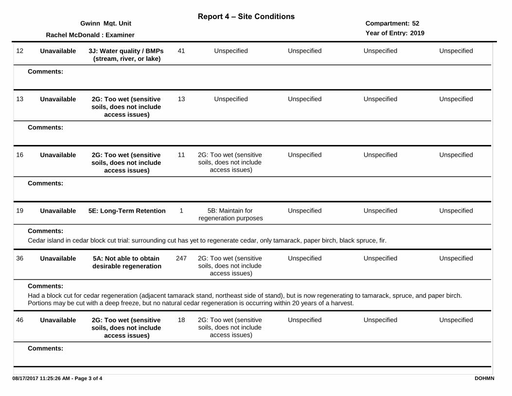
12 3J: Water quality / BMPs
(stream, river, or lake)
Unspecified41 Unspecified Unspecified Unspecified
Comments:
Unavailable
13 2G: Too wet (sensitive
soils, does not include
access issues)
Unspecified13 Unspecified Unspecified Unspecified
Comments:
Unavailable
16 2G: Too wet (sensitive
soils, does not include
access issues)
2G: Too wet (sensitive soils, does not include
access issues)
11 Unspecified Unspecified Unspecified
Comments:
Unavailable
19 5E: Long-Term Retention 5B: Maintain for regeneration purposes
1
Cedar island in cedar block cut trial: surrounding cut has yet to regenerate cedar, only tamarack, paper birch, black spruce, fir.
Unspecified Unspecified Unspecified
Comments:
Unavailable
36 5A: Not able to obtain
desirable regeneration
2G: Too wet (sensitive soils, does not include
access issues)
247
Had a block cut for cedar regeneration (adjacent tamarack stand, northeast side of stand), but is now regenerating to tamarack, spruce, and paper birch. Portions may be cut with a deep freeze, but no natural cedar regeneration is occurring within 20 years of a harvest.
Unspecified Unspecified Unspecified
Comments:
Unavailable
46 2G: Too wet (sensitive
soils, does not include
access issues)
2G: Too wet (sensitive soils, does not include
access issues)
18 Unspecified Unspecified Unspecified
Comments:
Unavailable
08/17/2017 11:25:26 AM - Page 3 of 4 DOHMN

Report 4 – Site ConditionsCompartment:Mgt. Unit
Year of Entry:: Examiner
Gwinn
Rachel McDonald
52
2019
47 2H: Blocked by physical
obstacle (e.g. upland
stand in a lowland area)
2H: Blocked by physical obstacle (e.g. upland
stand in a lowland area)
16 Unspecified Unspecified Unspecified
Comments:
Unavailable
65 5A: Not able to obtain
desirable regeneration
Unspecified6
Had a block cut for cedar regeneration (adjacent tamarack stand), but is now regenerating to tamarack, spruce, and paper birch. Can cut with a deep freeze, but no natural cedar regeneration is occurring within 20 years of a harvest.
Unspecified Unspecified Unspecified
Comments:
Unavailable
08/17/2017 11:25:26 AM - Page 4 of 4 DOHMN

SCA Category Acres
Mgt. Unit
Report 5 – PROPOSED SPECIAL CONSERVATION AREA* (SCA) DETAILS
Compartment:
Recommendation
* This is a partial list of SCAs for this compartment. Not included are those areas identified under other Department initiatives (Natural Rivers, Deer Wintering Areas, etc.). Those will be identified in separate, future map and report products.
Year of Entry:
SCA Name Detail Type
#Type!
Comments
08/17/2017 11:24:26 AM - Page 1 of 1 DOHMN
Type
Mgt. Unit Compartment:
Description
* This is a list of SCA's for this compartment along with a 1/4 mile buffer surrounding the compartment. Refer to the Special Conservation Area Map for locations of the below listed Conservation Areas.
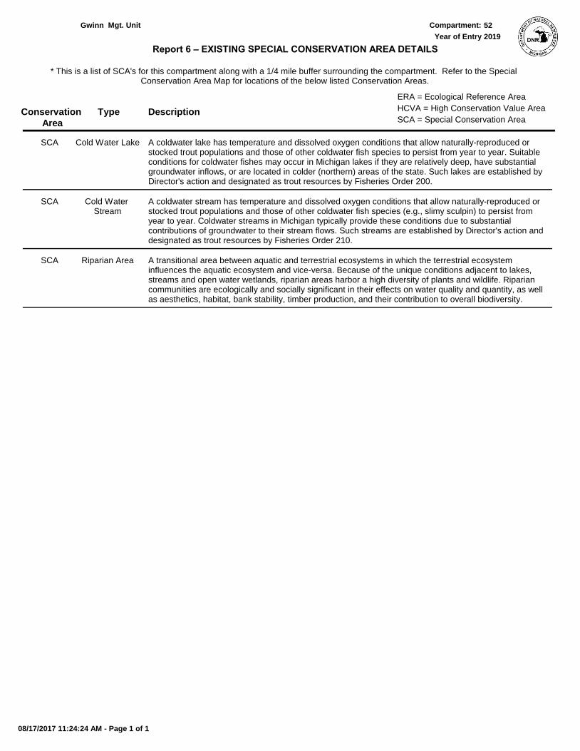
Report 6 – EXISTING SPECIAL CONSERVATION AREA DETAILS
Conservation
Area SCA = Special Conservation Area
HCVA = High Conservation Value Area
ERA = Ecological Reference Area
Year of Entry
Gwinn 52
2019
A coldwater lake has temperature and dissolved oxygen conditions that allow naturally-reproduced or stocked trout populations and those of other coldwater fish species to persist from year to year. Suitable conditions for coldwater fishes may occur in Michigan lakes if they are relatively deep, have substantial groundwater inflows, or are located in colder (northern) areas of the state. Such lakes are established by Director's action and designated as trout resources by Fisheries Order 200.
Cold Water LakeSCA
A coldwater stream has temperature and dissolved oxygen conditions that allow naturally-reproduced or stocked trout populations and those of other coldwater fish species (e.g., slimy sculpin) to persist from year to year. Coldwater streams in Michigan typically provide these conditions due to substantial contributions of groundwater to their stream flows. Such streams are established by Director's action and designated as trout resources by Fisheries Order 210.
Cold Water Stream
SCA
A transitional area between aquatic and terrestrial ecosystems in which the terrestrial ecosystem influences the aquatic ecosystem and vice-versa. Because of the unique conditions adjacent to lakes, streams and open water wetlands, riparian areas harbor a high diversity of plants and wildlife. Riparian communities are ecologically and socially significant in their effects on water quality and quantity, as well as aesthetics, habitat, bank stability, timber production, and their contribution to overall biodiversity.
Riparian AreaSCA
08/17/2017 11:24:24 AM - Page 1 of 1
Level 4
Cover Type AcresStand
Age
Size
DensityBA
Range
Mgt. Unit Report 7 – Forested Stands Compartment:S
t
a
n
d
General
Comments:
Year of Entry:
Gwinn
2019
52
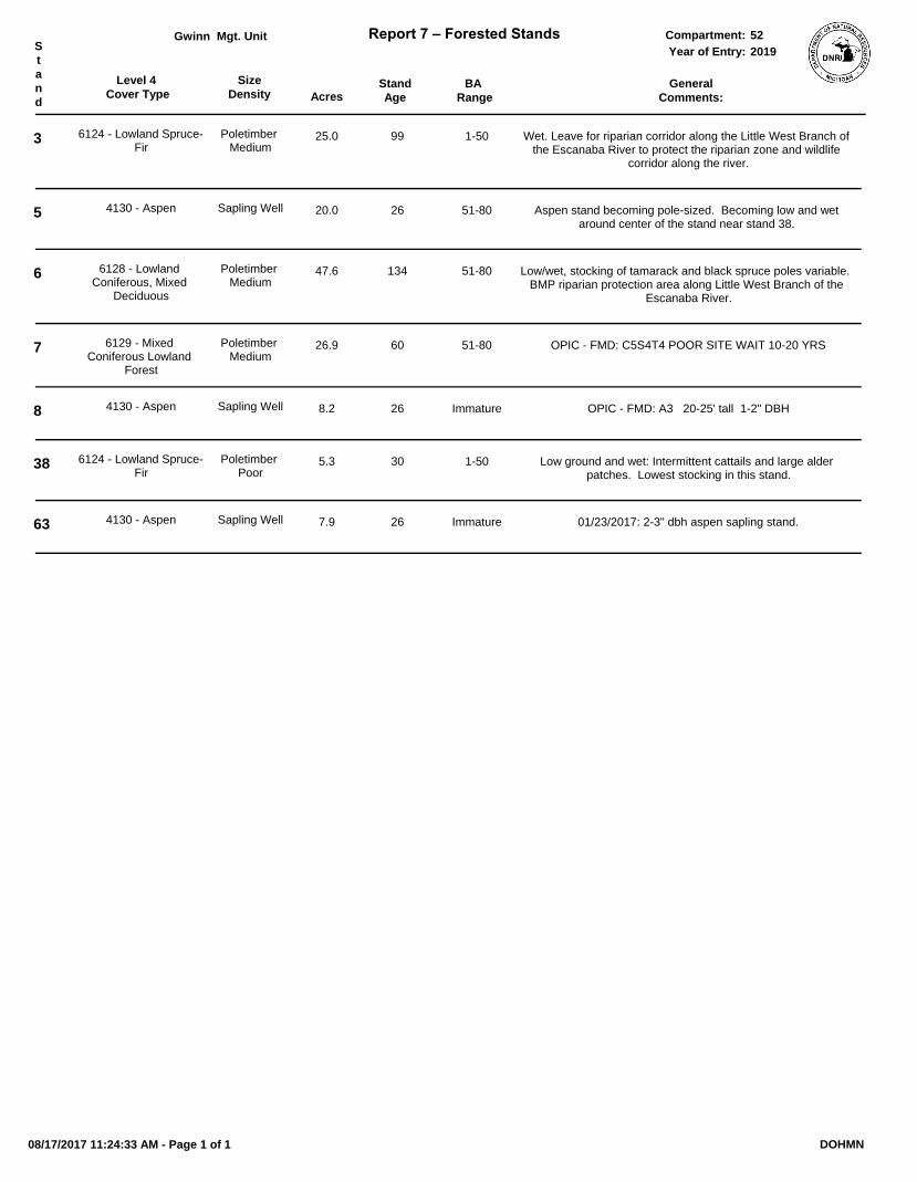
3 6124 - Lowland Spruce-Fir
Poletimber Medium
25.0 99 1-50 Wet. Leave for riparian corridor along the Little West Branch of the Escanaba River to protect the riparian zone and wildlife
corridor along the river.
5 4130 - Aspen Sapling Well 20.0 26 51-80 Aspen stand becoming pole-sized. Becoming low and wet around center of the stand near stand 38.
6 6128 - Lowland Coniferous, Mixed
Deciduous
Poletimber Medium
47.6 134 51-80 Low/wet, stocking of tamarack and black spruce poles variable. BMP riparian protection area along Little West Branch of the
Escanaba River.
7 6129 - Mixed Coniferous Lowland
Forest
Poletimber Medium
26.9 60 51-80 OPIC - FMD: C5S4T4 POOR SITE WAIT 10-20 YRS
8 4130 - Aspen Sapling Well 8.2 26 Immature OPIC - FMD: A3 20-25' tall 1-2" DBH
38 6124 - Lowland Spruce-Fir
Poletimber Poor
5.3 30 1-50 Low ground and wet: Intermittent cattails and large alder patches. Lowest stocking in this stand.
63 4130 - Aspen Sapling Well 7.9 26 Immature 01/23/2017: 2-3" dbh aspen sapling stand.
08/17/2017 11:24:33 AM - Page 1 of 1 DOHMN

Cover Type Acres
Mgt. Unit Report 8 – Nonforested Stands Compartment:
Stand General Comments:
Year of Entry:
Managed
Site
Gwinn 52
2019
78 2.1 OPIC - FMD: ROSS GRADE122 - Road/Parking Lot No
417 3.73105 - Mixed Upland Herbaceous Yes
418 1.53102 - Grass No
08/17/2017 11:24:38 AM - Page 1 of 1 DOHMN
![INDEX [] · # 910001 R Alfa Romeo 147 - F Alfa Romeo 156 - F Alfa Romeo 156 Sportwagon - F Alfa Romeo GT - F # 910002 R Audi A3 - R Audi A3 Sportback - R # 910003 R Audi A4 - R](https://cdn.vdocuments.site/doc/165x107/5b1d8eba7f8b9a173f8b75f4/index-910001-r-alfa-romeo-147-f-alfa-romeo-156-f-alfa-romeo-156-sportwagon.jpg)


