Download - CHARACTERISTICS OF OCEAN CURRENTS

CHARACTERISTICS OF OCEAN CURRENTS
Session 5.
1

Session Contents
1. The Ocean: A Driving Force for Weather and Climate (video)
2. Causes of Ocean Currents
3. Groups of Ocean Currents
4. Special Ocean Current Systems
5. Methods of Ocean Current Measurementsa. Eulerian Measurement Method
b. Lagrangian Measurement Method
c. Remote Mapping of Sea Surface Currents
2

The Ocean: A Driving Force for Weather and Climate
3Video Source: NASA Goddard (https://www.youtube.com/watch?v=6vgvTeuoDWY)

What are ocean currents?
• An ocean current is a massive movement of ocean water that is caused and influenced by various forces.
• Ocean currents impact humankind and the biosphere due to their influence on climate.
• Ocean currents also affect people in other ways. As an example, a knowledge of ocean currents is essential to the reduction of fuel consumption and time spent at sea.
4

What are ocean currents caused by
The major factors that determine the direction and speed of ocean currents can be divided into three types:
1. Tides,
2. Winds, and
3. Water Density Difference.
5

Currents Caused by Tides
• Tidal currents occur in conjunction with the rise and fall of the tides and are the only type of currents affected by the interactions of the earth, sun, and moon.
• Tidal currents are predictable and change in a very regular pattern.
• They are usually the strongest currents in coastal regions but are no direct importance to the circulation of the ocean waters.
6

Currents Caused by Tides(continued)• In the entrance to a bay
or in a river, the tidal current is on the reversing or rectilinear type.
• Out in the open sea, tidal currents change direction continually. Such currents are called rotary currents.
7
Graphic source: NOAA

Currents Driven by Winds
• The second factor that drives ocean currents is winds. Winds drive currents that are at or near the ocean's surface.
8
• Winds drive currents near coastal areas on a localized scale, and in the open ocean on a global scale.
Global Atmospheric Circulation https://cimss.ssec.wisc.edu/

Density-Driven Currents
• The last, but not the least, factor that drives currents is thermohaline circulation, i.e., a process driven by density differences in water due to temperature and salinity in different parts of the ocean.
• Currents driven by thermohaline circulation occur at both deep and shallow ocean levels and move much slower than tidal or wind-driven currents.
9

Groups of Ocean Currents by Water Depths1. Ocean Surface Currents
Primarily driven by winds, resulting in horizontal and vertical movement.
2. Ocean Deep Currents
The result of density differences in water which is controlled by the difference in temperature and salinity.
10
Graphic source: NOAA /Ocean Explorer
Groups of Ocean Currents
by Water Depths

Groups of Ocean Currents by Water Temperatures
11
1. Warm-water Currents
Warm water currents form near the equator creating a warmer climate near the coastlines.
2. Cold-water Currents
Cold water currents on the other hand form near the poles and travel towards the equator creating cooler climate near the coastlines.
Graphic source: NOAA
Groups of Ocean Currents
by Water Temperatures

Special Ocean Current Systems
• The equatorial currents system
• Western and eastern boundary currents
• The Antarctic Circumpolar Current and
• The Arctic Ocean
12

Equatorial Currents System
Every ocean, except the Arctic Ocean, has a North Equatorial Current, a South Equatorial Current and an Equatorial Counter Current. The North and South equatorial currents flow from east to west. The Equatorial Counter Current is located between the North and South equatorial currents and flows in opposition to them, that is, from west to east.
13

Global Boundary Currents Chart
14

Ocean Boundary Currents Systems
15
BoundaryCurrents
Atlantic Ocean Pacific Ocean IndianOceanNorth South North South
WesternGulf Stream
(warm)
Brazil Current (warm)
Kuroshio (warm)
East Australian
Current (warm)
Somali Current (warm)
Mozambique Current (warm)
Agulhas Current (warm)
EasternCanary Current (cold)
Benguela Current (cold)
California Current (cold)
Peru Current
West Australian Current (cold)

Antarctic Circumpolar Current
The Antarctic Circumpolar Current (ACC) is an ocean current that flows clockwise from west to east around Antarctica. An alternative name for the ACC is the West Wind Drift.
16

Arctic Ocean
There are no primary currents in the Arctic Ocean although there is a circumpolar flow. The Labrador Current (cold) and the East Greenland Current (cold) are outlets of the Arctic Ocean into the North Atlantic Ocean.
17

Ocean Currents Measurements
• Eulerian Measurement Method
– Current meters deployed on moorings
– Vertical profiling of horizontal currents using acoustic doppler current profiler (ADCP)
• Lagrangian Measurement Method
– surface current measurement: Drifters
– subsurface current measurement:
Ocean Gliders and Argo profiling floats
• Remote Mapping of Sea Surface Currents
– Using high-frequency (HF) Doppler radar networks
18

Eulerian Measurement Systems
• The Eulerian method is ideal for measuring temporal changes at multiple depths at representative or key sites, particularly for long-term time-series research, monitoring and data assimilation modeling.
• Eulerian surface current measurements using shore-based high-frequency (HF) radar systems provide spatial maps of surface current data.
19

Moored Current Meters
• Eulerian measurements involve describing fluid flow by measuring the speed and direction of the fluid at one point only.
• In this method, an instrument is anchored in the ocean at a given location, and the water movement is measured as it flows past the instrument.
20
An oceanographer deploys a current meter
in the 1920s while working in Alaska.
(source: NOAA/National Ocean Service)

Acoustic Doppler Current Profiler
21
An acoustic Doppler current profiler (ADCP) is a instrument that scientists use to measure how fast water is moving across an entire water column.

Applications of ADCP
Depending on the applications, ADCP can be distinguished among:• Moored ADCP,• Ship-mounted,• Side-looking, • Towed ADCP, or• Lowered ADCP.
22graphic source:
http://www.rowetechinc.com/img/blog/adcp_applications/adcp_deployments_clean.png

Moored ADCP
• Surface Moored ADCP
• Subsurface Moored ADCP
23

Surface Moored ADCP
• Surface moorings (deep water) – typically utilizes an ADCP, up or down-looking, to measure currents.
• In the case of down-looking systems, the ADCP can be installed at the surface or below the surface.
• For up-looking systems the ADCP is installed below the surface and measures currents towards the surface.
24

Subsurface Moored ADCP
• Subsurface moorings are typically anchored to the sea floor.
• Most oceanographic applications systems are up-looking and measure currents and waves.
• There are some applications where the ADCP is installed on the sea floor and in a down-looking orientation in order to conduct boundary layer studies.
25

Ship-mounted ADCP
• Ship-mounted ADCP is often referred as shipboard ADCP (SADCP).
• The SADCP is a hull-mounted ADCP which measures the velocity of the upper-ocean currents below the ship. When used in conjunction with the ship’s heading and navigation data, absolute currents in the upper ocean can be determined.
26

Side-looking ADCP
Side-looking ADCPs are typically utilized in large channels and in harbors to monitor currents. Flow can be determined by knowing the water level and bathymetry.
27Graphic source:http://www.teledynemarine.com

Lowered ADCPs
In order to obtain full-depth ocean velocities one or two ADCPs are lowered on a wire to some distance above the seabed and raised back to the surface. While the ADCPs are in the water they use acoustic pings to collect short (order 100m) velocity profiles measured in the frame of reference of the moving instruments.
28

Lagrangian Measurement Systems
• Surface drifters
• Subsurface floats: Used primarily in the deep ocean.
29

Surface Drifters
A drifter is an oceanographic device floating on the sea surface typically tracked by satellite to study ocean currents and other parameters such as water temperature and salinity.
30

Subsurface Floats
Argo is a global array of profiling floats that measures the temperature and salinity of the upper 2000 m of the ocean. This allows continuous monitoring of the temperature, salinity, and velocity of the upper ocean.
31

Ocean Gliders
An ocean glider is an autonomous, unmanned underwater vehicle equipped with a wide variety of sensors to monitor temperature, salinity, currents, and other ocean conditions.
32
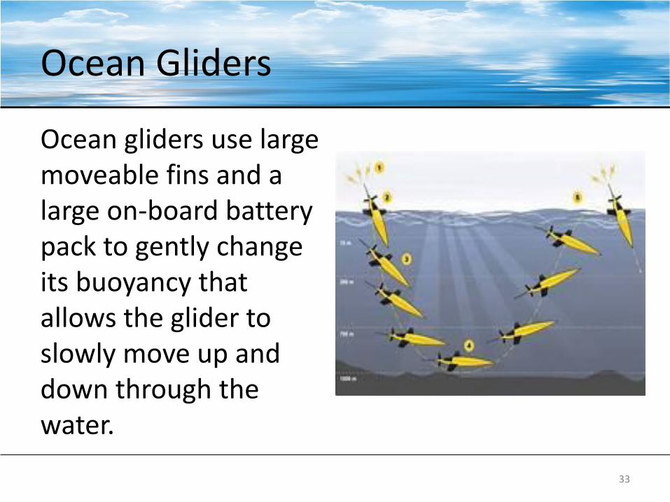
Ocean Gliders
Ocean gliders use large moveable fins and a large on-board battery pack to gently change its buoyancy that allows the glider to slowly move up and down through the water.
33
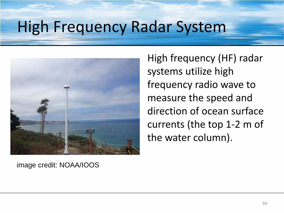
High Frequency Radar System
High frequency (HF) radar systems utilize high frequency radio wave to measure the speed and direction of ocean surface currents (the top 1-2 m of the water column).
34
image credit: NOAA/IOOS

High Frequency Radar System
Depending on the radio frequency, HF radar antennas (typically in pairs) can measure surface currents with horizontal resolutions from 500 m to 6 km up to 200 km off the coast.
35
http://boon.ucdavis.edu/current_plots.html

References
• https://doi.org/10.1175/JPO-D-15-0046.1
• https://marine.rutgers.edu/dmcs/ms501/2004/Notes/Wilkin20041104.htm
• https://cimss.ssec.wisc.edu/sage/oceanography/lesson3/intro.html
• NASA Ocean Motion http://oceanmotion.org/html/introduction-general.htm
36

Hands-on Exercise
37
For the purpose of familiarizing yourself with major ocean
currents, visit NOAA’s Web application, “JetStream Max”
at https://www.weather.gov/jetstream/currents_max
Note: Uncheck the
check-box labelled “All
Currents” as shown in
the image to the left
before you use the
application.

READING ASSIGNMENTS
38

Satellite Applications for Geoscience Education
39
https://cimss.ssec.wisc.edu/sage/about/about.html

Satellite Applications for Geoscience Education – Ocean Currents
40

NASA Ocean Motion
41
http://oceanmotion.org/html/
introduction-general.htm

References
• A Direct Determination of the World Ocean Barotropic Circulation https://doi.org/10.1175/JPO-D-15-0046.1
• Surface geostrophic currents from altimetry https://marine.rutgers.edu/dmcs/ms501/2004/Notes/Wilkin20041104.htm
42

It’s time for a break!!!
43


