
12-1
CHAPTER 12
ARCHAEOLOGICAL RESOURCES
By: Allan F. Moore PhD (Archaeologist)
12.1 Introduction
In compliance with the EIA and Terms of Reference for the establishment of Well sites,
pipelines, and the construction of gravel roads for the Belize Natural Energy (BNE), the
authors were asked to conduct an archaeological impact assessment in the areas that are to
be affected by the development. The properties concerned are the areas where two
prospective wells and connecting pipes in Spanish Lookout proper, are to be established.
The principal features are the two wells, with connecting pipes in the San Marcos area, a
pipe system to run the petrol from the San Marcos Well to the tank farm on the main road
into Spanish Lookout, and the continuation of the construction of a feeder gravel road to
the San Marcos wells.
The purpose of the assessment is to identify and document archaeological remains and/or
features (as defined by the National Institute of Culture and History Act, Chapter 331
Revised Edition 2000) that are there and to place these in their given geographic location in
the areas of study. The report will also offer recommendation/s for the protection and or
mitigation of any such remains prior to the implementation and as a result of the civil
works during the project. The report will include in it an archaeological impact assessment,
a description of the study area (Spanish Lookout and periphery including San Marcos), a
section explaining the methodology of the assessment), a discussion on the type of survey
and reconnaissance applied, the results, and recommendations and mitigations for the
findings.
The Archaeological assessment and survey will be conducted with full awareness of and
adherence to the National Institute of Culture and History Act, Chapter 331 Revised
12-2
Edition 2000.
12.2 Description of Areas
The areas of study include:
1) small areas within the Spanish Lookout community and
2) the San Marcos village area.
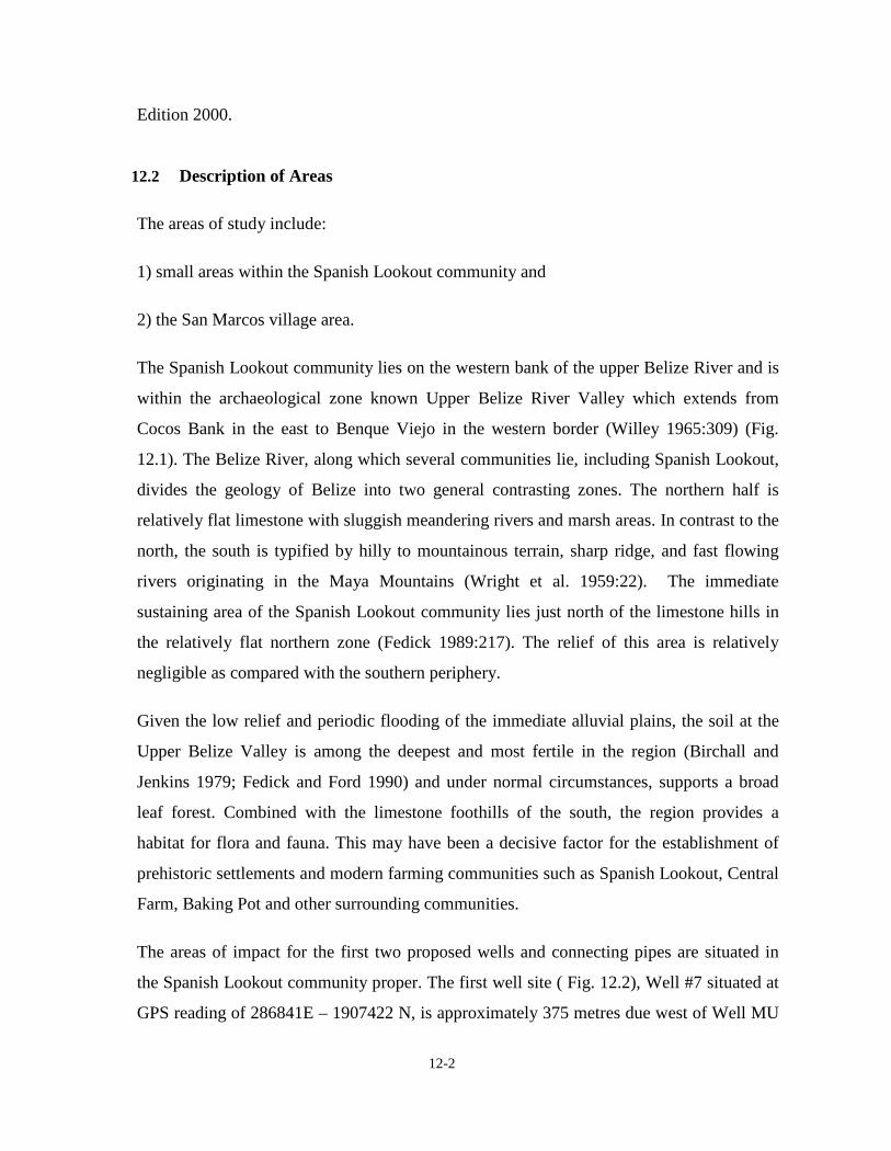
The Spanish Lookout community lies on the western bank of the upper Belize River and is
within the archaeological zone known Upper Belize River Valley which extends from
Cocos Bank in the east to Benque Viejo in the western border (Willey 1965:309) (Fig.
12.1). The Belize River, along which several communities lie, including Spanish Lookout,
divides the geology of Belize into two general contrasting zones. The northern half is
relatively flat limestone with sluggish meandering rivers and marsh areas. In contrast to the
north, the south is typified by hilly to mountainous terrain, sharp ridge, and fast flowing
rivers originating in the Maya Mountains (Wright et al. 1959:22). The immediate
sustaining area of the Spanish Lookout community lies just north of the limestone hills in
the relatively flat northern zone (Fedick 1989:217). The relief of this area is relatively
negligible as compared with the southern periphery.
Given the low relief and periodic flooding of the immediate alluvial plains, the soil at the
Upper Belize Valley is among the deepest and most fertile in the region (Birchall and
Jenkins 1979; Fedick and Ford 1990) and under normal circumstances, supports a broad
leaf forest. Combined with the limestone foothills of the south, the region provides a
habitat for flora and fauna. This may have been a decisive factor for the establishment of
prehistoric settlements and modern farming communities such as Spanish Lookout, Central
Farm, Baking Pot and other surrounding communities.
The areas of impact for the first two proposed wells and connecting pipes are situated in
the Spanish Lookout community proper. The first well site ( Fig. 12.2), Well #7 situated at
GPS reading of 286841E – 1907422 N, is approximately 375 metres due west of Well MU
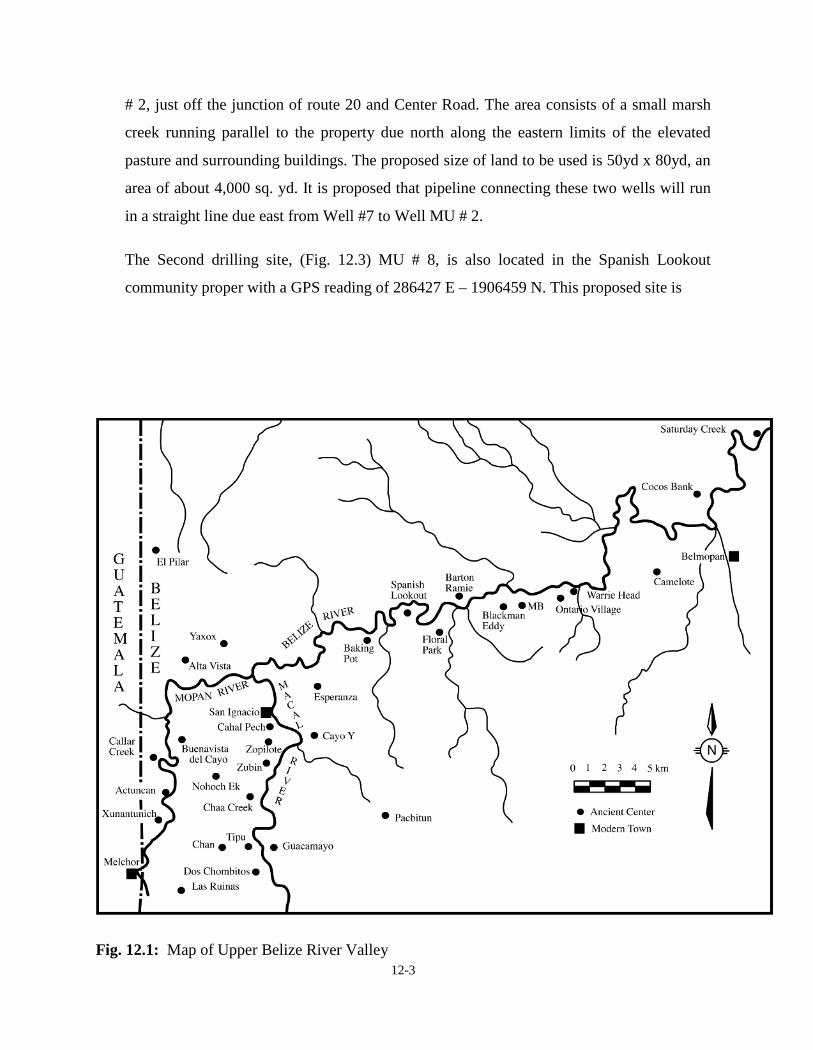
12-3
# 2, just off the junction of route 20 and Center Road. The area consists of a small marsh
creek running parallel to the property due north along the eastern limits of the elevated
pasture and surrounding buildings. The proposed size of land to be used is 50yd x 80yd, an
area of about 4,000 sq. yd. It is proposed that pipeline connecting these two wells will run
in a straight line due east from Well #7 to Well MU # 2.
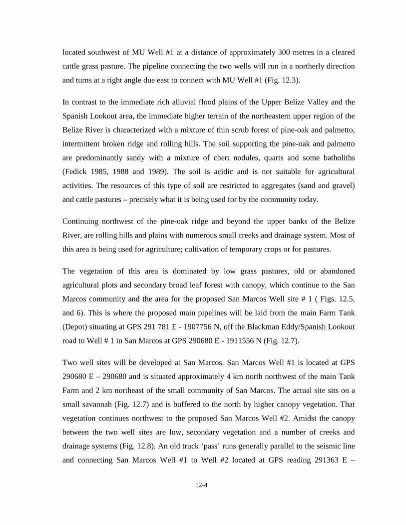
The Second drilling site, (Fig. 12.3) MU # 8, is also located in the Spanish Lookout
community proper with a GPS reading of 286427 E – 1906459 N. This proposed site is
Fig. 12.1: Map of Upper Belize River Valley
12-4
located southwest of MU Well #1 at a distance of approximately 300 metres in a cleared
cattle grass pasture. The pipeline connecting the two wells will run in a northerly direction
and turns at a right angle due east to connect with MU Well #1 (Fig. 12.3).
In contrast to the immediate rich alluvial flood plains of the Upper Belize Valley and the
Spanish Lookout area, the immediate higher terrain of the northeastern upper region of the
Belize River is characterized with a mixture of thin scrub forest of pine-oak and palmetto,
intermittent broken ridge and rolling hills. The soil supporting the pine-oak and palmetto
are predominantly sandy with a mixture of chert nodules, quarts and some batholiths
(Fedick 1985, 1988 and 1989). The soil is acidic and is not suitable for agricultural
activities. The resources of this type of soil are restricted to aggregates (sand and gravel)
and cattle pastures – precisely what it is being used for by the community today.
Continuing northwest of the pine-oak ridge and beyond the upper banks of the Belize
River, are rolling hills and plains with numerous small creeks and drainage system. Most of
this area is being used for agriculture; cultivation of temporary crops or for pastures.
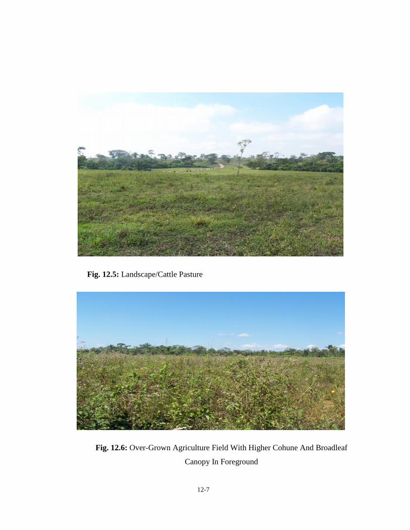
The vegetation of this area is dominated by low grass pastures, old or abandoned
agricultural plots and secondary broad leaf forest with canopy, which continue to the San
Marcos community and the area for the proposed San Marcos Well site # 1 ( Figs. 12.5,
and 6). This is where the proposed main pipelines will be laid from the main Farm Tank
(Depot) situating at GPS 291 781 E - 1907756 N, off the Blackman Eddy/Spanish Lookout
road to Well # 1 in San Marcos at GPS 290680 E - 1911556 N (Fig. 12.7).
Two well sites will be developed at San Marcos. San Marcos Well #1 is located at GPS
290680 E – 290680 and is situated approximately 4 km north northwest of the main Tank
Farm and 2 km northeast of the small community of San Marcos. The actual site sits on a
small savannah (Fig. 12.7) and is buffered to the north by higher canopy vegetation. That
vegetation continues northwest to the proposed San Marcos Well #2. Amidst the canopy
between the two well sites are low, secondary vegetation and a number of creeks and
drainage systems (Fig. 12.8). An old truck ‘pass’ runs generally parallel to the seismic line
and connecting San Marcos Well #1 to Well #2 located at GPS reading 291363 E –
12-5
1911966 N. It is proposed that the old truck trail be improved to provide access between
the San Marcos wells and to link the main road that is at the front of the property and
Fig. 12.2: Proposed site for MU Well # 7
Fig. 12.3: Proposed site for MU Well # 8

12-6
Fig. 12.4: Map of Proposed MU Wells # 7 & 8
12-7
Fig. 12.5: Landscape/Cattle Pasture
Fig. 12.6: Over-Grown Agriculture Field With Higher Cohune And Broadleaf
Canopy In Foreground

12-8
Fig. 12.7: Map Showing Prospective San Marcos Wells #1 & #2 Connecting Pipe Route, Proposed Road and Main Transect ForPipe From Well #s1 and 2 to Tank Farm. Inset Provides A Map Of The Isolated Mound Group With GPS Readings.
12-9
homes to the south.
12.3 Review of Literature on the Spanish Lookout Areas
Spanish Lookout is within the sphere of the upper Belize River Valley (Fig. 12.1) Studies
have shown however, that there are far more occurrences of prehistoric settlements south of
Spanish Lookout than there are in the north. In addition, archaeological records show
several major sites such as Baking Pot, Barton Ramie and Blackman Eddy which, together
with their peripheral settlement and sustaining areas, dotted the rich and fertile alluvial
plains of the upper Belize River Valley. These sites are near the Spanish Lookout area.
Baking Pot archaeological site is approximately 8 km up stream from Spanish Lookout and
is located on the southern banks of the Belize River.
The upper Belize River Valley sub-region of the Cayo District has been the focus of
archaeological investigations between 1924 and 1961 by the Carnegie Institute of
Washington, U.S.A. Although no extensive excavations were conducted, the site was
mapped, and an assessment of its settlement area was done (Ricketson 1931:4).
In 1949, salvage excavation was done by A.H. Anderson, then Archaeological
Commissioner for Belize (Moore 1999). In 1956, Gordon Willey (1965) of Peabody
Museum, as part of his Belize River Valley Settlement Survey, conducted a series of small
excavation at Baking Pot. Willey’s survey of the Belize River Valley determined numerous
prehistoric settlements dotting the upper Belize River Valley that later attracted further and
more detailed research to the area.
Since 1961, no archaeological research was conducted in the area until 1992, when The
Belize Valley Archaeological Reconnaissance Project (BVAR), under the direction of Dr.
Jaime Awe of the University of New Hampshire, started considerable excavations within the
site core of Baking Pot, and at several settlement clusters in the periphery
( Awe 1993). Around the same time, Dr. James Garber of the Texas State University at San
Marcos began archaeological work at Blackman Eddy (Garber 1991). The research by Awe
and Garber at Baking Pot and Blackman Eddy respectively, are still ongoing and have
provided considerable information on this section of the Belize Valley.

12-10
The results of all the investigations show that human activity in this sub-region in Belize,
goes back 10,000 to 8000 B.C. during what is known as the Paleo-Indian period. For the
subsequent Archaic Period (7000 to 1500 B.C.), several Lowe and Sawmill type projectile
points have been recorded in the area extending from Spanish Lookout to the Mountain Pine
Ridge (Lohse et al. 2006). Cahal Pech, Barton Ramie, and Blackman Eddy (Awe, Healy,
Garber et al., and Willey et al.) have produced considerable data on the earlier phases;
Preclassic period (1000 – 300 B.C. ). In contrast, Baking Pot and Spanish Lookout are
predominantly Classic Period (300 – 900 A.D.) sites extending into the Post Classic period
(1000-1400 A.D.)
Settlement surveys by Willey et al. (1965) have further noted that Maya settlements in the
area are concentrated along the fertile alluvium on the north side of the Belize River, or on
the alluvium and foothills on the south side of the river. In contrast, there is a marked
absence of Maya settlements within the scrub forests of pine, palmetto and oak that border
the alluvial valley to the north of the river. The likely reason for the difference in settlement
pattern is that the scrub forest lies in areas of sandy soils with outcrops of flint. The acidic
nature of these soils is not conducive to agriculture, and was also unappealing to the agrarian
Maya. This however, did not mean that the ancient Maya disregarded these areas
completely.
There is evidence at the site of Colha in northern Belize that the Maya exploited these chert-
bearing zones for flint to make projectile points, scrapers and other tools. On the east side of
the New River lagoon there is evidence which suggests the ancient Maya collected pine
resin and wood for incense, fuel and torches, and that they intentionally burnt the pine ridge
to attract deer who feed on the new grass that regenerates thereafter
But while there is relatively little evidence for ancient Maya utilization of pine ridge
environments, the same is not true for Archaic people and Paleo-Indians. Evidence for these
early inhabitants of Belize has been found in the sandy scrub forests of the country. This is
so in the Belize and Orange Walk Districts (see Lohse et al. 2006) where Preceramic

12-11
(10,000 –1500 B.C.) artifacts have been found in the sandy pine-oak-palmetto scrub forests
and savannahs. Supporting this apparent distribution is the discovery of an Archaic period
Lowe Point in a pine covered scrub forest just west of Spanish Lookout. The projectile point
fragment was discovered on the surface next to a small roadside quarry by members of the
BVAR project. It is probable that similar finds could be made in the area therefore
developers must be cognizant of this situation.
12.4 Survey and Research Methodology
Prior to visiting the proposed sites, research was conducted at the Institute of Archaeology
(IOA) to review maps and records of the study area and to put it into archaeological
perspective. The objective of the research at the IOA was to see if there was any record or
report of archaeological material on or around the area of influence.
Following the research at the IOA, a survey of the area, which lasted two days, was
embarked upon to specifically determine, record and map, any archaeological remains or
features that might be in the areas of the proposed development. These would include
evidence of Pre-Maya, ancient Maya, Historic-Colonial Period occupation and any other
artifacts or features that may qualify under the NICH Act.
As a result of the nature of the areas of study, particularly in the Spanish Lookout
community, cutting of transects lines was not required because the areas are in low grass
pastures among residential homes. GPS readings were obtained and the areas were visually
reconnoitered. The areas of impact measure about 50yd x 80 yd (4,000sq yd) each.
Similarly the 15 foot-wide pathway or right of way for the pipelines connecting the wells
were walked and visually surveyed. The proposed well sites in the San Marcos area were
likewise traversed and GPS reading were obtained. The pipeline routes connecting the two
wells were also examined visually.
Road alignments for the proposed road connecting San Marcos Well #1 to San Marcos
Well #2 were traversed. GPS readings were obtained at key areas along the alignment
(Fig. 12.7 Main Transect Route). The other proposed road alignment will connect the
present San Marcos road to the San Marcos Well #1. It is a relatively short distance that

12-12
will run east around the farm houses on pasture land to Well #1, for a distance of
approximately 1 km. The lack of vegetation of the areas allowed a thorough examination
and recording of suspected archaeological features.
The final area that was examined was the 15 foot-pathway that is to accommodate the right
of way for the main pipe line that is to be connected from the western flank of the farm
house to San Marcos Well #1 in a straight line due north northwest.
12.5 Result of Survey and Recommendation/mitigation
The proposed sites that are to be impacted upon by the establishment of drilling sites and
wells are relatively small and isolated from each other. Two of them are situated in the
Spanish Lookout community proper and the other two at San Marcus village. The two well
sites at Spanish Lookout will be connected to old established wells. The new Well # 7 will
be connected by pipelines to the already existing operating wells designated as Well
Michael Usher (MU) # 2 and the new Well MU #8. Similarly, approximately 4km from the
Tank Farm, situated on the Spanish Lookout /Blackman Eddy road, and oriented in a north
northwest direction, two new well sites will be prepared for future prospecting in this area.
The two sites are located in the same Spanish Lookout Oil Field. These two wells, San
Marcos #1 and San Marcos #2 will be connected to each other by a pipeline and connected
to a manifold to the main pipeline that empties into the main depot at the Farm Tank.
Perhaps due to the nature and physically special limitations of these small, but sometime
narrow areas on which work is projected, as in the case of the pipelines, no evidence of
prehistoric or any other cultural remains were encountered on any of the well sites,
pipelines or road alignments.
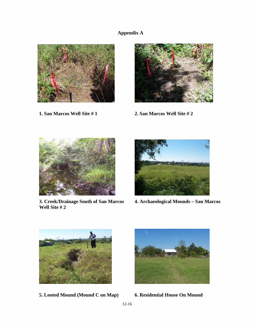
The survey shows however, that at a distance approximately 50 m off and immediately
south of San Marcos Well #1, there is an isolated mound group containing a total of five
mounds – four are aligned in a north-south orientation and the fifth mound is situated east,
approximately 40 m from the most southerly mound (Fig. 12.7). This mound (mound C)
contains a relatively large looters trench approximately 1.5 m long by a meter deep running
partially through its spine. Mound E on the other hand presently serves as the foundation

12-13
on which one of the land owner’s houses is built. The mounds were designated A to E and
GPS coordinates were obtained for each (Fig. 12.7). These mounds will in no way be
affected by the activities of the Wells or the construction of the road as both activities are
located outside the confines of the mounds. The road has been re-routed and is now aligned
at an east-west direction, around the houses (approx. 200m) through the pasture and on to
the well site.
There is however, a questionable feature that was observed and recorded located on the
Farm Tank/San Marcos transect. It is a small, isolated mound of pine ridge cobbled located
in the pine ridge palmetto environment. It has a diameter of approximately 5 metres and
0.5m high. It is located at 291656 E – 1908087 N, being north northwest of the Tank Farm
at about 5m off the transit line.
Although no other evidence of prehistoric remains was located during the survey caution
should be taken when preparing all well sites, in particular the San Marcos Well site # 1.
The existence of mounds nearby dictates that caution be exercised when working in that
area because of finding archaeological features beneath the surface is possible. Likewise
the opening of trenches for pipelines and the construction of all roads must proceed with
caution. Should any archaeological features are encountered the operation must be halted
and to inform the Institute of Archaeology immediately to determine and recommend and
or execute a course of action. In general therefore, it would be prudent to recommend that
all excavations whether for wells, pipeline trenches, road construction building foundations
and the likes be treated with due diligence as archaeological materials may exist anywhere
especially giving it relative proximity to the prehistoric settlements along the Upper Belize
River Valley.

12-14
REFERENCES CITED
Awe, J.J., editor1993 Belize Valley Archaeological Reconnaissance Project: Progress Report of 1992
Field Season. Trent University, Peterborough, Ontario, Canada.
Birchall, C.J. and R.W. Jenkins1979 The Soil of the Belize Valley. Supplementary Report # 15. Overseas
Development Administration, Land Development Centre, Surbiton, England.
Conlon, James1993 Corporate Group Structure at the Bedran Group, Baking Pot, Belize: Preliminary
Comments on Excavation Results from the 1992 Season of Investigations. In TheBelize Valley Archaeological Reconnaissance Project: Progress Report of the1992 Field Season. Edited by Jaime J. Awe. Trent University, Peterborough,Ontario.
Fedick, S.1985 Prehistoric Maya Land Use Pattern in the Upper Belize Valley. Paper presented at
the 50th Annual Meeting of the Society of American Anthropology, Denver.
Fedick, S.1988 Prehistoric Maya Settlement and Land Use in the Upper Belize River Valley
Area, Central America. Ph. D. Dissertation, Arizona University.
Fedick, S.1989 The Economics of Agriculture Land Use and Settlement in the Upper Belize
Valley. In Research in Economic Anthropology. Prehistoric Maya Economies ofBelize edited by P. A. McAnany and B.L. Isaac, pp 315 – 354 JAI Press Inc.,Conn.
Fedick, S. and A. Ford1990 The Prehistoric Agricultural Landscape of the Central Maya
Lowland: An examination of local variability in a Regional context.World Archaeology.
Garber, J. et. al1991 The Blackman Eddy Archaeological Projec: Result of the 1991 Field Season:Southwest Texas State University.
Garber, James F., M. Kathryn Brown, Jaime J. Awe, and Christopher J. Hartman2004 Middle Formative Prehistory of the Central Belize Valley: An Examination of
Architecture, Material Cultue, and Socioploitical Change at Blackman Eddy. In,The Ancient Maya of the Belize Valley: Half a Century of ArchaeologicalResearch. Edited by, James F. Garber, pp. 25-47. University of Central FloridaPress, Orlando.

12-15
Lohse, Jon, Jaime Awe, Cameron Griffith, Robert Rosenswig, & Fred Valdez Jr.2006 Preceramic Occupations in Belize: Updating the Paleo-Indian and Archaic
Record. Latin American Antiquity.
Moore, Allan1997 Microsettlement-Analysis in the Belize River Valley: Archaeological Investigations
at Atalaya, a formal Patio Group at Baking Pot. Unpublished Ph.D. dissertation,Institute of Archaeology, University College London, London.
Ricketson, O. G., Jr.1931 Baking Pot, British Honduras. Carnegie Institution of Washington, Publication
no. 403, Contributions to American Archaeology, no. 1. Washington, D. C.
Willey, G. R., W. R. Bullard, Jr., J. B. Glass, and J. C. Gifford1965 Prehistoric Settlement Patterns in the Belize Valley. Papers of the Peabody
Museum of Archaeology and Ethnology, No. 54. Harvard University, Cambridge.
12-16
Appendix A
1. San Marcos Well Site # 1 2. San Marcos Well Site # 2
3. Creek/Drainage South of San Marcos 4. Archaeological Mounds – San MarcosWell Site # 2
5. Looted Mound (Mound C on Map) 6. Residential House On Mound


