
Beyond Pretty Pictures:
Topographic Labels in 3D Maps of High Terrain
www.melown.com
Ondřej Procházka, CEO Melown Technologies SE

Melown Tech is a software-development company
in the 3D mapping business
www.melown.com

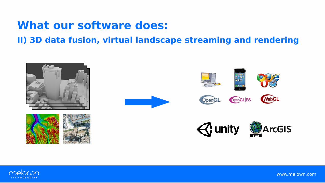
What our software does:
I) Computer-vision and deep-learning driven reality capture
www.melown.com
What our software does:
II) 3D data fusion, virtual landscape streaming and rendering
www.melown.com

Applications
• VR and AR
• interactive simulations
• gaming
• geospatial (3D mapping)
www.melown.com

The conceptual problem behind “3D mapping”
www.melown.com

www.melown.com
Cartography

www.melown.com
Cartography

Cartography:
A map is a diagramatic representation of an area, or a symbolic depiction
emphasizing relationship between elements of space
3D mapping:
A map is mostly orthophotos draped over DEMs, viewed from arbitrary angle
www.melown.com

Cartography:
A map works with a hierarchy of features, both intellectual and visual
3D mapping:
A map aims for data visualization, or simply for visual realism (“pretty pictures”)
www.melown.com

Cartography:
A map relies on cartographic principles which have evolved in 4300 years.
3D mapping:
A map relies on applied computer graphics, which has evolved in ~50 years.
www.melown.com

www.melown.com
Where cartography gives you this...

www.melown.com
… 3D mapping gives you this...

www.melown.com
… or this.

Our goal in this talk:
to create a FOSS-based map application
• leveraging on the benefits of 3D (realism, arbitrary angles), while
• staying true to cartographic principles
www.melown.com

A global high-terrain 3D map with VTS
www.melown.com

www.melown.com
Inspiration

www.melown.com
Inspiration
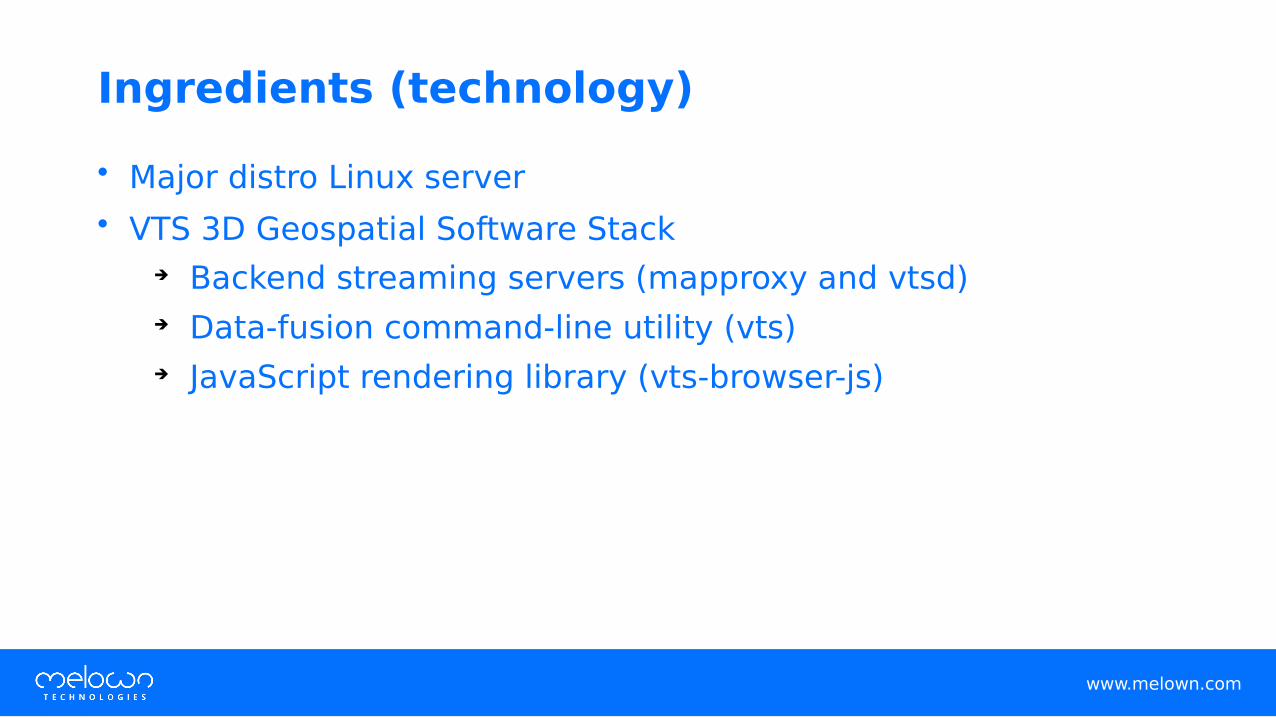
Ingredients (technology)
• Major distro Linux server
• VTS 3D Geospatial Software Stack➔ Backend streaming servers (mapproxy and vtsd)
➔ Data-fusion command-line utility (vts)
➔ JavaScript rendering library (vts-browser-js)
www.melown.com

Ingredients (data)
• Global Sentinel2 Cloudless mosaic (by EOX IT Gmbh)
• Viefinder Panoramas 3 arc second DEM (by Johnathan de Ferranti)
• OpenStreetMap (by OSM contributors, Klokan Technologies Gmbh)
• “The Ultras” (by Peaklist.org)*)
*) Peaklist.org “Ultras” is not a public-domain dataset. See the authors’ site for licensing.
www.melown.com

Intellectual hierarchy – topographic prominence
www.melown.com

www.melown.com
Prerequisite: VTS Backend
On Ubuntu 16.04 or 18.04:
$ sudo apt install vts-backend
www.melown.com
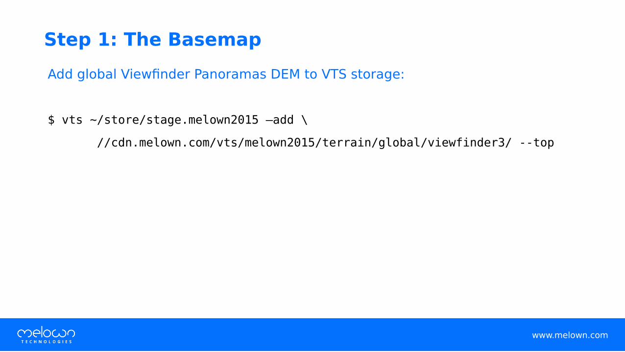
Step 1: The Basemap
Add global Viewfinder Panoramas DEM to VTS storage:
$ vts ~/store/stage.melown2015 –add \
//cdn.melown.com/vts/melown2015/terrain/global/viewfinder3/ --top

Create a VTS storage view at ~/store/map-config/high-terrain:
www.melown.com
{
"storage": "../stage.melown2015",
"tilesets": ["terrain-viewfinder3"],
"credits": {},
"boundLayers": {
"eox-it-sentinel2-cloudless"
:"//cdn.melown.com/vts/melown2015/imagery/global/eox-it-sentinel2-cloudless/boundlayer.json"
},
"freeLayers": {},
"view": {
"surfaces": { "terrain-viewfinder3": ["eox-it-sentinel2-cloudless"] },
"freeLayers": {}
},
"position": [["obj",-101.3,47.116,"float",0,0,-90,0,9333674,45],
"version": 1
}
Step 1: The Basemap (cont’d)

At http://<your-server>:8070/vts/store/map-config/high-terrain:
www.melown.com
Step 1: The Basemap (check)

www.melown.com
Step 2: The Ultra-prominent Peaks
Download the dataset:*)
$ wget http://cdn.melown.com/pub/vts-tutorials/high-terrain/world1500.json
-O ~/mapproxy/datasets/world1500.json
*) Peaklist.org “Ultras” is not a public-domain dataset. See the authors’ site for licensing.
Define a geodata free layer in mapproxy (create /etc/vts/mapproxy/examples.d/peaklist-org-ultras.json):
www.melown.com
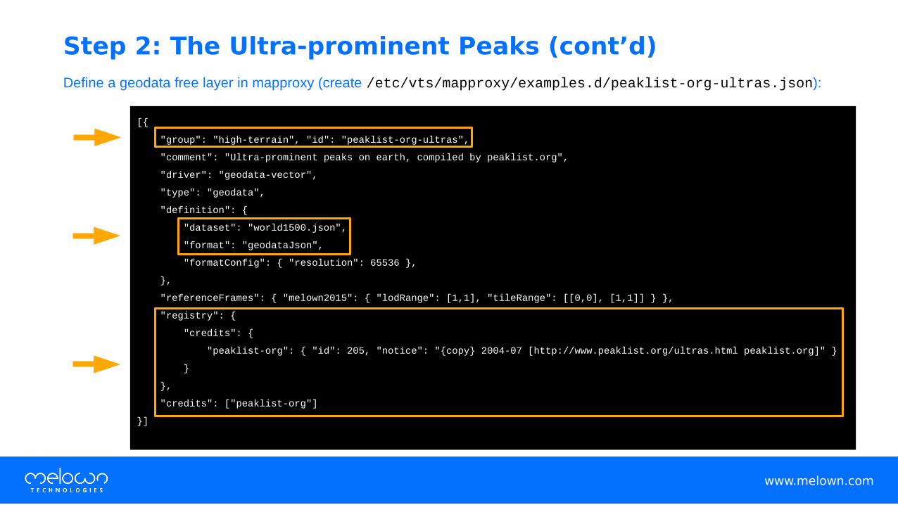
[{
"group": "high-terrain", "id": "peaklist-org-ultras",
"comment": "Ultra-prominent peaks on earth, compiled by peaklist.org",
"driver": "geodata-vector",
"type": "geodata",
"definition": {
"dataset": "world1500.json",
"format": "geodataJson",
"formatConfig": { "resolution": 65536 },
},
"referenceFrames": { "melown2015": { "lodRange": [1,1], "tileRange": [[0,0], [1,1]] } },
"registry": {
"credits": {
"peaklist-org": { "id": 205, "notice": "{copy} 2004-07 [http://www.peaklist.org/ultras.html peaklist.org]" }
}
},
"credits": ["peaklist-org"]
}]
Step 2: The Ultra-prominent Peaks (cont’d)

Create a stylesheet for the layer (edit ~/store/stylesheets/peaklist-org-ultras.style):
www.melown.com
{
"constants": {
"@name-solver": {"if":[["has","$name"],"$name","$Name"]},
"@ele": {"if":[["has","$elevation"],"$elevation","$Elevation"]},
"@feet": {"round":{"mul":[3.2808399,{"str2num":"@ele"}]}},
"@ele-solver": {"if":[["==","#metric",true],"{{'round': {'str2num':'@ele'}}} m","{@feet} ft"]},
"@id-solver": "{@ele-solver} {@name-solver}"
},
"layers": {
"peak-labels": {
"label": true,
"label-source": {"uppercase":"{@name-solver}\n{@ele-solver}"},
"label-no-overlap": false,
"label-size": 19,
"label-stick": [70,5,2,255,255,255,128],
"culling": 92,
"hysteresis": [1500,1500,"@id-solver",true]
}
}
}
Step 2: The Ultra-prominent Peaks (cont’d)

Add the layer to the storage view, at ~/store/map-config/high-terrain:
www.melown.com
{
"storage": "../ht-stage.melown2015",
"tilesets": ["terrain-viewfinder3"],
"credits": {},
"boundLayers": {
"eox-it-sentinel2-cloudless":
"//cdn.melown.com/vts/melown2015/imagery/global/eox-it-sentinel2-cloudless/boundlayer.json"
},
"freeLayers": {
"peaklist-org-ultras": "/mapproxy/melown2015/geodata/high-terrain/peaklist-org-ultras/freelayer.json"
},
"view": {
"surfaces": { "terrain-viewfinder3": ["eox-it-sentinel2-cloudless"] },
"freeLayers": {
"peaklist-org-ultras": { "style": "/store/stylesheet/peaklist-org-ultras.style?4" }
}
},
"position": ["obj",-101.3,47.116,"float",0,0,-90,0,9800000,45],
"version": 1
}
Step 2: The Ultra-prominent Peaks (cont’d)

At http://<your-server>:8070/vts/store/map-config/high-terrain:
www.melown.com
Step 2: The Ultra-prominent Peaks (check)

Solve occlusions by the rule of higher prominence (edit ~/store/stylesheets/peaklist-org-ultras.style)
www.melown.com
{
"constants": {
...
"@prom-solver": {"mul":[-1,{"str2num":{"if":[["has","$prom"],"$prom","$Prom"]}}]}
},
"layers": {
"peak-labels": {
...
"label-no-overlap": true,
"label-no-overlap-factor": ["div-by-dist","@prom-solver"],
...
}
}
}
Step 2: The Ultra-prominent Peaks (cont’d)

At http://<your-server>:8070/vts/store/map-config/high-terrain:
www.melown.com
Step 2: The Ultra-prominent Peaks (check)
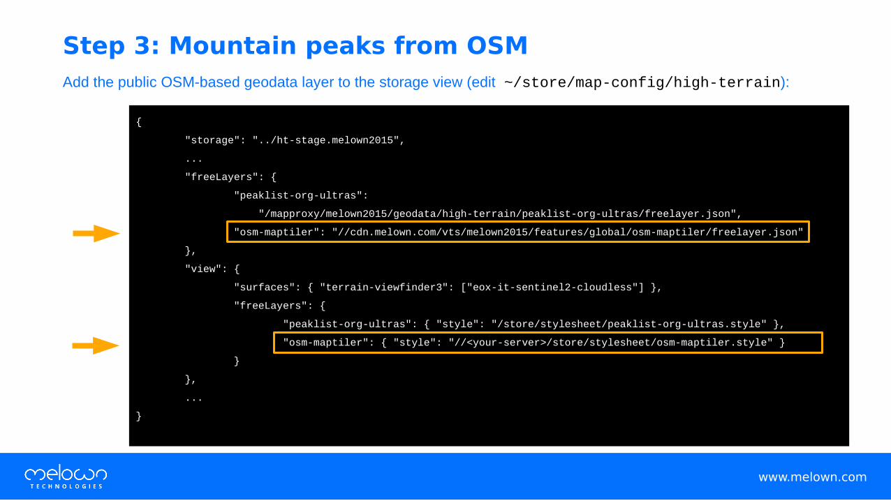
Add the public OSM-based geodata layer to the storage view (edit ~/store/map-config/high-terrain):
www.melown.com
{
"storage": "../ht-stage.melown2015",
...
"freeLayers": {
"peaklist-org-ultras":
"/mapproxy/melown2015/geodata/high-terrain/peaklist-org-ultras/freelayer.json",
"osm-maptiler": "//cdn.melown.com/vts/melown2015/features/global/osm-maptiler/freelayer.json"
},
"view": {
"surfaces": { "terrain-viewfinder3": ["eox-it-sentinel2-cloudless"] },
"freeLayers": {
"peaklist-org-ultras": { "style": "/store/stylesheet/peaklist-org-ultras.style" },
"osm-maptiler": { "style": "//<your-server>/store/stylesheet/osm-maptiler.style" }
}
},
...
}
Step 3: Mountain peaks from OSM

Create a stylesheet for the layer (create ~/store/stylesheets/osm-maptiler.style):
www.melown.com
{
"constants": {
"@feet": {"round":{"mul":[3.2808399,{"str2num":"$ele"}]}},
"@name-solver": {"if":[["has","$name"],{"if":[["any",["!has","$name:en"],["==",{"has-latin":"$name"},true]],"{$name}","{$name}\n{$name:en}"]},""]},
"@ele-solver": {"if":[["==","#metric",true],"{{'round': {'str2num':'$ele'}}} m","{@feet} ft"]},
"@peak-name": {"if":[["has","$ele"],"{@name-solver}\n({@ele-solver})","({@name-solver})"]},
"@prominence": {"add":[{"if":[["has","$ele"],{"mul":[-0.0001,{"str2num":"$ele"}]},0]},{"if":[["has","$prominence"],{"mul":[-0.3048,{"str2num":"$prominence"}]},0]}]},
"@osmid": {"if":[["has","$osm_id"],"$osm_id",""]},
"@id-solver":"{@osmid} {@ele-solver} {@name-solver}"
},
"layers": {
"peaks": {
"filter": ["all",["==","#group","mountain_peak"]],
"visible": { "if": [["!=","@name-solver",""], true, false ] },
"dynamic-reduce": ["scr-count2",1,50],
"label": true,
"label-color":[255,255,255,255],
"label-stick": [70,5,2,255,255,255,128],
"label-size": 19,
"label-source": "@peak-name",
"label-font": "@main-font",
"label-no-overlap": true,
"label-no-overlap-factor": ["div-by-dist","@prominence"],
"zbuffer-offset": [-0.25,0,0],
"culling": 94,
"hysteresis": [1500,1500,"@id-solver",true]
}
}
}
Step 3: Mountain peaks from OSM (cont’d)

At http://<your-server>:8070/vts/store/map-config/high-terrain:
www.melown.com
Step 3: Mountain peaks from OSM (check)

Change style for ultra-prominent peaks (edit ~/store/stylesheets/peaklist-org-ultras.style):
www.melown.com
{
"constants": {
"@name-solver": {"if":[["has","$name"],"$name","$Name"]},
"@ele": {"if":[["has","$elevation"],"$elevation","$Elevation"]},
"@feet": {"round":{"mul":[3.2808399,{"str2num":"@ele"}]}},
"@ele-solver": {"if":[["==","#metric",true],"{{'round': {'str2num':'@ele'}}} m","{@feet} ft"]},
"@id-solver": "{@ele-solver} {@name-solver}"
},
"layers": {
"peak-labels": {
"label": true,
"label-source": {"uppercase":"{@name-solver}\n({@ele-solver})"},
"label-stick": [70,5,2,255,233,0,128],
"label-color": [255,233,0,255],
"label-no-overlap": false,
"label-size": 19,
"label-stick": [70,5,2,255,255,255,128],
"culling": 92,
"hysteresis": [1500,1500,"@id-solver",true]
}
}
}
Step 4: The visual hierarchy

Add visual hierarchy rules to OSM data (edit ~/store/stylesheets/osm-maptiler.style):
www.melown.com
{
"constants": {
...
"@peak-rank": {"discrete2":["@prominence",
[[-1501,0],[-1499,1],[-751,1],[-749,2],[-326,2],[-324,3],[-164,3],[-162,4],[-2,4],[-1,5]]]},
"@peak-name2": {"if":[["==","@peak-rank",0],{"uppercase":"@peak-name"},"@peak-name"]}
},
"layers": {
"peaks": {
"filter": ["all",["==","#group","mountain_peak"]],
...
"label-color": {"linear2":["@peak-rank",[[1,[255,233,0,255]],[5,[230,230,230,255]]]]},
"label-stick": {"linear2":["@peak-rank",[[1,[70,5,2,255,233,0,128]],[5,[70,5,2,230,230,230,128]]]]},
"label-size": {"discrete2":["@peak-rank",[[0,19],[1,18],[2,17],[3,16],[4,15],[5,14]]]},
"label-source": "@peak-name2",
...
}
}
}
Step 4: Visual hierarchy (cont’d)

At http://<your-server>:8070/vts/store/map-config/high-terrain:
www.melown.com
Step 4: Visual hierarchy (check)

Live demo of the maphttp://rigel.mlwn.se/high-terrain
Sources of VTS informationvtsdocs.melown.com
github.com/Melown
www.melown.comwww.melown.com
![[CREATING LABELS] MAKING TEXT DESIGNING LABELS … · [CREATING LABELS] MAKING TEXT DESIGNING LABELS PRINTING LABELS COMPLETED LABELS USEFUL FUNCTIONS USER'S GUIDE / Español Printed](https://cdn.vdocuments.site/doc/165x107/5e718e59f26dfc19d238892e/creating-labels-making-text-designing-labels-creating-labels-making-text-designing.jpg)


