Sainsbury Logan & Williams Ref: Lara J Blomfield Solicitors Fax: 06-835 6746 Cnr Tennyson Street and Cathedral Lane Phone: 06-835 3069 PO Box 41 Napier
BEFORE THE BOARD OF INQUIRY
IN THE MATTER of the Resource Management Act 1991
AND
IN THE MATTER
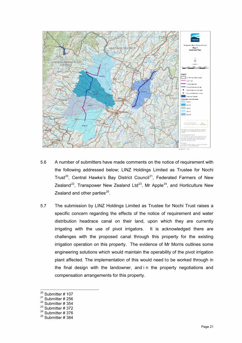
of the Tukituki Catchment Proposal
STATEMENT OF EVIDENCE OF Stephen Graeme DAYSH
TABLE OF CONTENTS 1. INTRODUCTION ............................................................................................................ 1 2. SUMMARY AND CONCLUSIONS ................................................................................. 6 3. CONSULTATION ASSOCIATED WITH THE RWSS ..................................................... 7 4. THE MANA WHENUA WORKING PARTY .................................................................. 12 5. NOTICE OF REQUIRMENT – ASSESSMENT OF ALTERNATIVES AND CONDITIONS ....................................................................................................................... 18 6. THE INTEGRATED MITIGATION AND OFFSET APPROACH ................................... 30 7. RECOMMENDATIONS FROM WITNESSES FOR CONDITION CHANGES ............. 34 8. RESPONSE TO CONDITION REQUESTS NOT ADDRESSED BY OTHER WITNESSES ......................................................................................................................... 37 9. APPENDICES ............................................................................................................... 52 Appendix 1 The Environmental, Social and Cultural Section of the Feasibility Report
(Section 3)...................................................................................................... 52 Appendix 2 The Draft Minutes of the 31 August 2013 Ruataniwha Stakeholder Group
Meeting. ......................................................................................................... 53 Appendix 3 The Approved Minutes of the 31 August 2013 Ruataniwha Stakeholder
Group. ............................................................................................................ 54 10. EXHIBITS .................................................................................................................. 55 Exhibit SGD 1: Mana Whenua Working Party report ........................................................... 55 Exhibit SGD 2: RWSS Part D Proposed Conditions – Updated September 2013 .............. 56 Exhibit SGD 3: Excerpt from the New Zealand Gazette, No. 38, 28 March 2013 ............... 57
Page 1
1. INTRODUCTION
1.1 My name is Stephen Graeme Daysh.
1.2 I am a Director and Principal Planner in the Napier office of Environmental
Management Services Limited (“EMS”), a specialist environmental planning
consulting company that I founded in 1994.
1.3 I have a Bachelor of Regional Planning (Honours) degree from Massey
University and have over 30 years of experience as an environmental planner
and project manager. I am a member of the New Zealand Planning Institute,
the Resource Management Law Association, the New Zealand Geothermal
Association and the International Geothermal Association. I am a certified
Commissioner (Chairs endorsement) under the Ministry for the Environment
“Making Good Decisions” programme.
1.4 Over the last 20 years, while at EMS I have been the project manager / lead
consultant for a number of significant environmental permitting projects
associated with large energy infrastructure developments in New Zealand and
Asia. Some of these involved re-consenting long-standing existing assets
under the Resource Management Act 1991 (“RMA”) process and others were
new projects seeking consents after feasibility studies had been undertaken.
The larger projects for which I have had a major role in coordinating the
environmental investigations and consenting processes are listed below:
(a) Wayang Windu Geothermal Plant Consents Project - Indonesia (1994-
1996)
(b) Kamojang Geothermal Plant Expansion Project - Indonesia (1997)
(c) Ohaaki Geothermal Plant Re-consenting Project (1997-1998)
(d) Tauhara I Geothermal Consents Project (1996-1999)
(e) Taranaki Combined Cycle II Gas Plant Consents Project (2000-2001)
(f) Cobb Hydro Plant Re-consenting Project (2001-2002)
(g) Marsden B Coal-fired Repowering Project (2004-2006)
(h) Wairakei Geothermal Plant Re-consenting Project (1999-2007)
(i) Te Mihi Geothermal Plant Consents Project (2007-2008)
Page 2
(j) Hauāuru mā raki Wind Farm Consents Project (2007-2010)
(k) Waitahora Wind Farm Consents Project (2008-2009)
(l) Tauhara II Geothermal Plant Consents Project (2008-2010).
1.5 I have also had extensive experience in designating infrastructure assets.
Before forming EMS, I worked for Works Consultancy Services Limited. In
1992 I established and was the National Environmental Manager for Works
Environmental Management, a division of Works Consultancy Services Limited,
and prior to that between 1988 and 1991 I was the Planning Manager for that
company in their Waikato and Bay of Plenty Division after moving from the
Wellington office where I was employed as a Senior Planner.
1.6 With Works Consultancy Services’ focus on State Highway roading projects I
led the investigations into and the subsequent designation (in several cases) of
a number of significant State Highway Roading Projects for Transit New
Zealand including:
(a) SH1 Wellington/Kapiti Western Corridor Study
(b) SH 1 Levin Bypass
(c) SH1 Mission to Hallets Bay Realignment
(d) SH1 Cambridge Bypass
(e) SH2 Tauranga Route J Expressway
(f) SH2 Te Puke Bypass
(g) SH2 Katikati Bypass
(h) SH30 Rotorua Eastern Arterial
(i) SH1 Hamilton to Tamahere Realignment Projects
1.7 In 1995 and 1996 I was engaged by Transit New Zealand as the Peer Reviewer
for the Wellington Urban Motorway Designation process. Aside from the
Hauāuru mā raki wind farm project, which involved designating a 30km 220kV
transmission line, my more recent significant designation experience has been
as sole Commissioner hearing the Te Kauwhata Bypass Notice of Requirement
(which had a wide range of community and ecological issues associated with it),

Page 3
and as the lead consultant for the Whakatu Arterial designation process in
Hawke’s Bay where the Notice of Requirement and AEE studies are currently in
preparation.
1.8 Prior to being engaged to assist with the Ruataniwha Water Storage Scheme
(“RWSS”) I had worked for various clients on a number of water storage
feasibility studies since the early 1990s associated with hydro-generation /
irrigation opportunities within the Clutha, Hawea, Waingaro, Tukituki,
Whangaehu, and Mohaka Catchments. This included major reviews of new
hydro dam opportunities (including necessary Transmission Upgrades and
Irrigation potential) on the Upper and Lower Clutha Rivers for Contact Energy in
1996 and again in 2012.
1.9 A range of clients have engaged me to advise on RMA and associated land
issues in due diligence processes for the prospective purchase of the following
hydro-electric scheme assets; Waipori, Clyde, Roxborough, Cobb, Waihi, and
Matahina. In 1998, I was appointed as the planning advisor to the Interim
Development Board set up to establish Genesis Energy Limited as it was
assessing the purchase of the Huntly, Tongariro Power Development, and
Waikaremoana generation assets from the Crown.
1.10 I have been intimately involved in four previous RMA Board of Inquiry
processes as the lead consultant for Contact Energy’s Te Mihi and Tauhara II
geothermal and Hauāuru mā raki wind farm projects, and as the Section 42A
Peer Reviewer for the Waterview Connection roads of national significance
project in Auckland. In 2011 the Tauhara II Project was awarded the trophy in
the Major Projects category at the Resource Management Law Association
Awards and a Highly Commended Award in the Nancy Northcroft New Zealand
Planning Institute Awards.
1.11 Since March 2011 I have been engaged by the Hawke’s Bay Regional Council
(“HBRC”) and then the Hawke’s Bay Regional Investment Company Limited
(“HBRIC Ltd”) on the RWSS, firstly leading the environmental component of the
feasibility study, and from late 2012 as the consenting manager for the RWSS
applications. Over this time I have been closely involved in the following
specific tasks:

Page 4
(a) Assisting with the stakeholder consultation programme, focused on the
Ruataniwha Stakeholder Group, and the Pan Sector Group1
(b) Facilitation of the Land Use Intensification and Mana Whenua Working
Parties2
(c) Briefing and coordinating the various environmental investigations and
reports associated with both the feasibility study phase and the applications
and Assessment of Environmental Effects (“AEE”) document3
(d) Co-authoring the report entitled “Ruataniwha Water Storage Scheme:
Alternatives Assessment for Primary Distribution System – Zones A to D”
which is Schedule Four of the Notice of Requirement4
(e) Co-authoring the report entitled “Ruataniwha Water Storage Scheme:
Proposed Integrated Mitigation and Offset Approach” which is Report K6 in
the RWSS application documentation5
(f) Co-authoring the preparation of the AEE6
(g) Coordinating the drafting of a suite of proposed resource consent
conditions for consideration by the Board of Inquiry7.
1.12 I have also been involved in a number of preliminary landowner briefings and
discussions and more recently have assisted Mr Hansen to co-ordinate initial
property negotiations with landowners in the RWSS reservoir footprint area
associated with implementing a proposed mitigation and offsetting project in
that area (as discussed by Mr Hansen and Mr Kessels in their evidence).
Purpose and Scope of Evidence 1.13 The purpose of my evidence is to:
(a) Present an updated set of Proposed Conditions that reflect the position of
HBRIC Ltd after consideration of submissions on the RWSS as assessed
by the various experts who are giving evidence.
1 Described in RWSS Folder 2, Tab 1, Section 28 2 ibid 3 RWSS Folder 2, Tab 1 4 RWSS Folder 1, Tab 2 Schedule 4 5 RWSS Folder 3, Tab 6 6 RWSS Folder 2, Tab 1 7 RWSS Folder 2, Tab 2
Page 5
(b) Explain the stakeholder consultation process and provide my opinion on
that process based on my experience with other similar projects.
(c) Outline the Mana Whenua Working Party process including an update
since the RWSS application documentation was finalised in early May
2013.
(d) Discuss the process involved in preparing the assessment of alternatives
for the Zones A to D Primary Distribution Network notice of requirement
and respond to submissions on the designation.
(e) Finally I give a process summary associated with the development of the
Integrated Mitigation and Offset Approach.
1.14 I have ordered my evidence under the following main heading:
(a) The Consultation Process for the RWSS
(b) The Mana Whenua Working Party
(c) The Notice of Requirement Alternatives Assessment and Conditions
(d) The Integrated Mitigation and Offset Approach
(e) An update of the Proposed Conditions based on advice from other
witnesses
(f) Responses on points raised by submitters regarding conditions that are not
dealt with by other witnesses
Expert Code of Conduct 1.15 I have read the Code of Conduct for Expert Witnesses in section 5 of the
Environment Court’s Practice Note (2011). I agree to comply with that Code of
Conduct. Except where I state that I am relying upon the specified evidence of
another person, my evidence in this statement is within my area of expertise. I
have not omitted to consider material facts known to me that might alter or
detract from the opinions which I express.

Page 6
2. SUMMARY AND CONCLUSIONS
2.1 I have been fully involved in consultation and stakeholder engagement on the
RWSS since I started work on the project in March 2011.
2.2 Formalised stakeholder engagement processes have occurred which involved
the establishment and/or engagement with multiple groups, including the Mana
Whenua Working Party, Ruataniwha Stakeholder Group, a wide range of
community groups, landowners, the Land Use Intensification Working Party, a
Pan Sector Group, the Key Farmer Reference Group and the Hawke’s Bay
District Health Board.
2.3 The Mana Whenua Working Party was established in November 2012, with
representatives appointed from HBRIC Ltd, Te Taiwhenua o Tamatea and Te
Taiwhenua o Heretaunga.
2.4 The consultation undertaken in the context of the Mana Whenua Working Party
(and through preparation of the cultural impact assessments) ensured that all
substantive cultural issues were clearly “on the table” and mana whenua
representatives were fully involved through the process.
2.5 Outside of formalised stakeholder engagement processes, I consider that there
has been ample information and time available for the broader public to become
familiar with the issues and m aterial related to the RWSS, and t o make their
views known, either directly to HBRC and HBRIC Ltd, or through other means
such as submissions
2.6 Overall, my view is that HBRC, and subsequently HBRIC Ltd, have taken a
thorough and measured approach to stakeholder engagement and consultation
for the RWSS.
2.7 HBRIC Ltd has lodged a Notice of Requirement for the Zones A to D Primary
Distribution System which included an assessment of alternatives in
accordance with the requirements of the RMA.
2.8 I consider that the process undertaken to assess the alternatives for the notice
of requirement reflected leading planning practice, which included an early and
broad options analysis of realistic engineering alternatives and a structured
multi-disciplinary / multi-criteria assessment methodology to assess the
Page 7
identified technical and environmental considerations relevant to the
alternatives.
2.9 A cornerstone of the RWSS proposal is the Integrated Mitigation and Offset
Approach. The Approach has been developed through extensive technical
assessments and consultation. Five projects are proposed in response to the
potential effects of the RWSS. The projects collectively set out biodiversity
restoration and enhanc ement strategies and ap proaches for offsetting effects
on recreation, cultural and heritage values, phosphorus inputs to the streams
and the availability and quality of in-stream habitat.
2.10 The estimated total cost provision for offset mitigation requirements over a 30
year period equates to approximately $8.7 million, with the most significant
costs incurred in the first ten years of the project.
2.11 I have proposed a number of changes to the proposed conditions lodged with
the RWSS applications in May 2013. These changes are in response to
evidence prepared for the hearing by experts advising HBRIC Ltd, some of
whom have recommended condition changes after considering submissions
seeking either general outcomes or specific conditions.
2.12 In addition, there are number of condition matters that I have addressed myself
in response to various condition requests and relief sought by submitters.
3. CONSULTATION ASSOCIATED WITH THE RWSS
3.1 Consultation is undoubtedly an important element in planning for, and
delivering, large infrastructure projects and claims of “a lack of” or “inadequate”
consultation is often a common theme in RMA cases dealing with such projects.
While consultation is not a m andatory legal requirement for those lodging
resource consent applications or notices of requirements, it is well accepted as
good practice. Schedule Four of the RMA states that AEE’s should identify the
persons affected by the proposal, the consultation undertaken, if any, and any
response to the views of any person consulted.
3.2 My specific role and responsibilities have been associated with the RWSS
component of the Tukituki Catchment Proposal. I have been f ully involved in
consultation and stakeholder engagement on the RWSS since I started work on
the project in March 2011, following the completion of the pre-feasibility stage.
At this time, there had already been significant stakeholder engagement around
Page 8
both the Hawke’s Bay Water Strategy (discussed in the evidence of Ms Codlin)
and water storage opportunities through the Ruataniwha pre-feasibility stage
(discussed in the evidence of Mr Hansen and Dr Wakefield).
3.3 A number of submitters including; Jenny Baker8, Operation Patiki9 Hawea
Tomoana10, Eugenie Sage11, Ngai Te Upokoiri ki Omahu Marae,12 Ngāti
Kahungunu Iwi Incorporated13, and Waipatu Marae/Ngai Hawea, Ngati Hori,
Ngati Hinemoa14 claim that consultation has not been adequate.
3.4 Dr Wakefield has already covered the process of engagement with iwi and
hapu. This included the commissioning of Cultural Impact Assessments
(“CIAs”), consultation with marae and hapu by the authors of those
assessments, the direct attendance by HBRC and HBRIC Ltd representatives at
a number of marae based meetings, and the convening of the Mana Whenua
Working Party in late 2012 as agreed between HBRIC Ltd, Te Taiwhenua o
Heretaunga and Te Taiwhenua o Tamatea.
3.5 As a member of the Mana Whenua Working Party, I can confirm there was
discussion within that group about the need to offer marae based briefings at
marae along the Tukituki River around the time the RWSS application
documentation was being completed and l odged with the EPA, to provide an
update on the work of the Working Party and the key issues which had been
assessed through that process. I am aware that a number of these marae
meetings were held and both Mr Hansen and I offered to attend the meetings.
However, the other members of Working Party who convened these meetings
preferred to front the meetings themselves.
3.6 The Mana Whenua Working Party also facilitated presentations on the RWSS at
two hui in March 2013. These were the “Fish Hook Summit”, an annual hui a
iwi focusing on environmental matters convened by Ngāti Kahungunu Iwi
Incorporated, on 7 March 2013 and a hui a hapu held in Waipawa on 27 March
2013. These hui were well advertised and well attended.
8 Submitter # 216 9 Submitter # 252 10 Submitter # 331 11 Submitter # 362 12 Submitter # 357 13 Submitter # 359 14 Submitter #395
Page 9
3.7 In terms of the general criticisms over the consultation process for the RWSS I
am aware from my experience with other large projects that whatever is done
by an applicant in this area, some individuals and parties will always desire
more discussion and/or more time for them to assimilate information. However,
at some stage a dec ision has to be m ade by the applicant that enough
consultation has been done and that it is time for it to lodge its applications.
3.8 There is also a general theme running through some of the submissions (and in
various comments from parties reported in the media over the last two years)
that HBRC and HBRIC Ltd may have been “holding back RMA relevant
information to its advantage” and not providing access to all possibly relevant
information in a timely way. I disagree that this has been the case.
3.9 I consider that there has been ample information and time for interested people,
not directly involved in the formalised stakeholder processes that I discuss
below to become familiar with the issues and material, and to make their views
known, either directly to HBRC and HBRIC Ltd, or through other means such as
submissions. I n fact, over the last two years HBRC and H BRIC Ltd have
provided regular project updates to all regional ratepayers via various
communication means, including newsletters, full page updates in local
newspapers and via media releases. N umerous parties and i ndividuals have
provided comments on the RWSS in local and national media so there seems
little chance that people, with a g enuine interest in accessing relevant
information, have not been alerted to the existence of the RWSS and the issues
it raises.
3.10 The core environmental studies and reports associated with the RWSS
(including their key findings and recommendations) prepared for the feasibility
stage have been publ icly available on the HBRC website since September
2012, some eight months prior to the final application documents being lodged
and made publicly available in May 2013. All of the “Final Draft” RWSS
Application documents were uploaded to the HBRC website around the middle
of March 2013, six weeks prior to them being formally lodged with the EPA and
well over three months prior to the closing of submissions on the RWSS
applications in August 2013.
3.11 I note by way of general approach, HBRIC Ltd was generally careful not to
place these reports in the public domain until they were concluded, albeit drafts
of all the key reports were discussed with the relevant stakeholder and working
Page 10
party representatives as part of their preparation. While sometimes requested
to release preliminary drafts, HBRIC Ltd was concerned this would lead to
‘misinformation’ or potential confusion as the assessments evolved, and before
the relevant outputs were incorporated in the Scheme though proposed
mitigation and option refinement in a range of areas. I understand this may have
caused some frustration by members of the public and interested parties and
can appreciate this, but I consider the timing of final reports being released was
reasonable, as just explained.
3.12 The sheer volume of material and getting through the project information is a
challenge for some parties. I fully acknowledge this concern and therefore
attempted as best as I could to put together the project components and key
findings in a clear and relatively concise AEE. In discussions with parties who
were struggling with the weight of information I stressed to them to focus on the
AEE document as the “roadmap” for the project information and then to look at
the more detailed reports that they were interested in to get the further detail
they needed.
3.13 I refer above to the RWSS feasibility study information published in September
2012. The “Ruataniwha Water Storage Project: Feasibility Report to Council,
HBRC Water Initiatives Group, September 2013” (“Feasibility Report”)
discussed in the evidence of Mr Hansen covered the technical, environmental,
social and cultural, and economic feasibility for the project. I was responsible
for the environmental feasibility component of this report. The feasibility study
was a s ubstantial and important exercise covering an eighteen month period
guided by the Ruataniwha Stakeholder Group. Rather than paraphrasing this
important process in the body of my evidence, I attach the following extracts
that form part of the overall report, along with the key stakeholder meeting
minutes which included a draft of the report:
Appendix 1 The Environmental, Social and Cultural Section of the Feasibility
Report (Section 3)
Appendix 2 The Draft Minutes of the 31 A ugust 2013 Ruataniwha
Stakeholder Group Meeting including the Record of Discussion
on the Draft Council Feasibility Report Environmental, Social and
Cultural Studies & Community Engagement Sections (Appendix
4 of the Report)
Page 11
Appendix 3 The Approved Minutes of the 31 August 2013 Ruataniwha
Stakeholder Group.
3.14 The Tukituki Choices process described in the evidence of Ms Codlin provided
another excellent opportunity for public comment and input into Tukituki
Catchment planning as a whole through September and October 2012, leading
up to the HBRC and HBRIC Ltd decision in late October 2012 to proceed with
further developing and lodging RWSS and Change 6 elements of the Tukituki
Catchment Proposal together, and seeking that they be determined by a Board
of Inquiry.
3.15 Based on my experience with a significant number of similar large projects, my
view is that HBRC, and subsequently HBRIC Ltd, have taken a thorough and
measured approach to stakeholder engagement and consultation for the
RWSS. The RWSS AEE15 outlines the details of this process with the
outcomes summarised in Section 28.10 as:
(a) Input to Scheme shaping through the early appointment and
involvement of the Leadership Group.
(b) Communication with, and input from the Ruataniwha Stakeholder Group
through 19 meetings held in Waipawa starting in May 2010, including
agreement of the group to the range and content of the environmental
studies undertaken to support the feasibility decision.
(c) Active involvement of the environmental groups on t he Ruataniwha
Stakeholder Group in the development and prioritisation of elements of
the five proposed Integrated Mitigation and Offset projects.
(d) Numerous meetings, presentations and discussions with a wide range of
community groups.
(e) Regular briefings with landowners on whose properties Scheme
infrastructure will be l ocated to assist with refining the primary
distribution system and to form a basis for land access agreements.
(f) Involvement of nominated members of the Ruataniwha Stakeholder
Group in the Land Use Intensification Working Party process.
15 RWSS Folder 2, Tab 1

Page 12
(g) The convening of a Mana Whenua Working Party to provide a forum for
Mana Whenua represented by a number of groups to work with HBRIC
Ltd representatives to develop effective ways of addressing the
recommendations of the various cultural impact assessments which
have been prepared for the Scheme.
(h) Input from a P an Sector group into the development of the proposed
conditions for the management of the Production Land Use element of
the Scheme, as part of a wider brief which also assisted HBRC with the
approach to limit setting developed for Change 6.
(i) Feedback from a K ey Farmer Reference Group into the details of the
proposed conditions for the management of the Production Land U se
element of the Scheme, as these were being drafted.
(j) Liaison with the Hawke’s Bay District Health Board in the drafting of
proposed conditions associated with Public Health matters.
4. THE MANA WHENUA WORKING PARTY
4.1 While a num ber of Cultural Impact Assessments had been pr epared for the
feasibility stage of the project (i.e. up to September 2012) there equally were a
number of recommendations from these reports that needed t o be di scussed
further and implemented.
4.2 As explained in Section 28.6 of the AEE16 a Mana Whenua Working Party was
established after a meeting held on 19 November 2012 involving myself, Mr
Newman and Mr Hansen from HBRIC Ltd, Professor Maaka and Mr Mohi from
Te Taiwhenua o Tamatea and Mr Apatu representing Te Taiwhenua o
Heretaunga. This meeting was convened after the decision had been made to
move on from the feasibility stage to preparing the RMA application
documentation for the RWSS and i n response to the following findings and
recommendations contained in the Feasibility Report:
“In relation to the recommendations contained in the Cultural Impact
Assessment Report we consider the following matters are relevant
considerations:
16 RWSS Folder 2, Tab 1

Page 13
a) The recommendations regarding governance and m anagement
associated with the Tukituki Catchment seem to be largely addressed by
the co-governance function of the recently established HBRC Regional
Planning Committee whose function is to oversee the development of
policy and plan instruments for the catchment
b) The recommendations associated with “mauri” have been r ecognised
and addressed through the development of the integrated mitigation and
offset report, with iwi representation proposed on the administering Trust
c) Council is assessing the implementation of higher minimum flow limits to
address the historic low flow issues in the catchment, as part of the
upcoming Plan Change.
We consider that further discussions should be held with Te Taiwhenua O
Tamatea and Te Tai whenua O Heretaunga in relation to the other key
recommendations such as:
a) How to realise potential social and ec onomic benefits for tangata
whenua
b) Potential involvement of tangata whenua in monitoring
c) How best to define and recognise any unregistered wahi tapu / wahi
taonga; and
d) Historic Places Act authority requirements including the development of
appropriate Accidental Discovery Protocols.”
4.3 At the 19 N ovember 2012 meeting, I suggested a c ombined Working Party
approach which, after discussion, was agreed. I suggested this initiative based
on successful approaches that I had helped co-ordinate between mana whenua
and Contact Energy during the Hauāuru mā raki Wind Farm and Tauhara II
Geothermal Plant consenting processes.
4.4 In the Hauāuru mā raki situation, a coastal Waikato iwi, Ngati Tahinga (whose
rohe extends from north of Raglan to Port Waikato), worked collaboratively with
the project team from the project inception to assess a wide range of cultural
and environmental issues. This process resulted in an A greement between
Ngati Tahinga and Contact Energy presented to the Board of Inquiry for that
case by the iwi. The agreement was founded on Ngati Tahinga having the ‘first
right’ to co-ordinate and undertake a l arge part of fourteen ecological offset

Page 14
projects that had been agreed with the Department of Conservation and other
parties, along with significant annual training and cultural project funding.
4.5 The Tauhara II process built on s ome long-standing relationships Contact
Energy had established with hapu in the Wairakei and Tauhara areas of Taupo,
associated with their operations on t he Wairakei-Tauhara Geothermal Field.
The situation with the Tauhara II project (a new 250MW geothermal power plant
and steamfield planned for east of Taupo Township) was quite complex as the
project area covered several Maori owned blocks of land, and a wider range of
hapu were directly affected as mana whenua than had previously been involved
during the Wairakei re-consenting process. A fter a de tailed and t horough
working party process covering approximately six months, two Agreements
were signed, one w ith a Wairakei Hapu Collective (building on t heir prior
agreement associated with Wairakei Power Station Re-consenting) and the
other with a Tauhara Hapu Collective. These agreements covered a range of
matters including agreement to “minimum conditions” and annual funding to
Trusts set up to administer environmental and cultural projects of relevance to
hapu. The agreements were presented to the Tauhara II Board of Inquiry by
the two hapu collective groups, with the Board commenting in their decision
that, “In the context of a nat ionally significant project we were pleasantly
surprised at the extent to which agreement has been reached”.
4.6 The approach agreed at the 19 November 2012 meeting was for HBRIC Ltd, Te
Taiwhenua o T amatea and Te Taiwhenua o H eretaunga to nominate three
representatives each onto a Working Party and then for a Terms of Reference
to be developed by the group. Mr Ratima, Mr Paku and Dr Whyte were
nominated by Te Taiwhenua o Heretaunga; Professor Maaka, Mr Gregory, and
Mr Mohi were nominated by Te Taiwhenua o Tamatea; and Mr Hansen, Ms
Letica and I were nominated by HBRIC Ltd.
4.7 The final Mana Whenua Working Party report is attached as Exhibit SGD1.
The Working Party Terms of Reference are attached as Appendix A of the
report and Table 2 sets out the various hui and milestones associated with the
process between November 2012 and July 2013. The Final Report was signed
by eight of the nine Working Party Members on 22 August 2013.
4.8 At a key planning session held on 24 January 2012, the Mana Whenua Working
Party discussed the following three key issues that were derived from the Terms
of Reference.
Page 15
• Meeting Social and Economic Opportunities
• Environmental Mitigation and Monitoring
• Cultural and Accidental Discovery Protocols
4.9 These three key areas form the structure of the “Agreed Approach” in Table 3 of
the Report which includes both Working Party Comments and t he Agreed
Approach associated with each of these three key issues. Through the
process, three additional issues were tabled as part of the Agreed Approach
under the following headings:
• Deforestation of the Tukituki Catchment
• Investment and Representation
• Use of Mana Whenua Working Party Model for Future Processes
4.10 The Agreed Approach references an Agreement between HBRIC Ltd and Te
Taiwhenua o Tamatea which provides for (among other things):
(a) Agreement between the parties as to certain minimum resource consent
conditions associated with matters of interest to mana whenua
(b) A first right for a Trust established by Te Taiwhenua o T amatea to
secure the contracts to undertake the five projects identified in the
“Ruataniwha Water Storage Scheme: Integrated Mitigation and Offset
Approach (HBRIC May 2013f)17 filed with the RWSS applications
(c) Provision of an educ ation and training fund with a pr iority to support
those who whakapapa to, or can evidence affiliation with, the
Ruataniwha District.
4.11 The matters covered in the Agreement were derived from discussions at a
Working Party hui held on 21 March 2013. After presenting these and
discussing them with Mr Newman, the Managing Director of HBRIC Ltd, I
coordinated the drafting of the Agreement and a draft copy was circulated to all
Working Party members prior to Easter. T he Agreement has subsequently
been discussed and ratified at HBRIC Ltd meetings and by the Te Taiwhenua o
Tamatea Governance Board.
17 RWSS Folder 4, Tab 6

Page 16
4.12 I understand the Agreement will be made available to the Board of Inquiry by Te
Taiwhenua o Tamatea, as part of them addressing their submission on the
RWSS.
4.13 As set out in Table 3 o f the Mana Whenua Working Party Report, there is a
range of other “Agreed Actions”. One of the most significant, in my opinion, is
the influence that the Mana Whenua Working Party has had in terms of HBRIC
Ltd requiring the prospective Design and C onstruct contractors to include a
“Hawke’s Bay Industry Participation Policy Statement” in their tenders. T he
Working Party has also tabled a Mana Whenua Values and A spirations
document with the prospective contractors and this will be part of the evaluation
of the tenders received for this aspect. In RMA terms, I consider that this is a
real and practical demonstration of the Section 5 theme of enabling people and
communities to provide for their social, economic, and cultural well-being, along
with a practical expression of kaitiakitanga of relevance under Section 7.
4.14 A footnote to Table 3 records that: “The Working Party Members who have
signed this report wish to record that those members who have not signed this
report participated fully in the Working Party process, including definition of the
key issues and in the discussions on the Agreed Approach set out in Section
6.0 (Table 3)”.
4.15 Working Party member Dr Whyte, who is now the Acting Chief Executive of
Ngāti Kahungunu Iwi Incorporated, was the only member who did not sign the
Final Working Party Report. Dr Whyte had advised the Working Party prior to
the 22 August 2013 meeting that, at a ‘hui a hapu’ held at Matahiwi Marae on
31 July 2013, a motion had been pa ssed “That Ngāti Kahungunu (Iwi Inc)
should lead the proposal to ensure that the tino rangatiratanga of each hapu is
maintained and recognised and that the mana of the Tukituki is maintained and
enhanced.” and that “This motion has been actioned by filing a submission in
opposition to the proposed dam”. She also advised that as a r esult, Ngāti
Kahungunu Iwi Incorporated was unable to sign the Mana Whenua report at
that stage and would not be attending any future Mana Whenua Working Party
hui.
4.16 I attended the 31 July 2013 hui a hapu at Matahiwi marae, along with Mr
Maxwell from HBRC, and make three observations about this hui.

Page 17
(a) Dr Whyte had s tressed at previous Working Party Meetings the
importance for her that the draft findings of the Working Party be
presented to a hui a hapu as this was appropriate tikanga.
(b) At a Working Meeting held on 5 J uly 2013 t here was an ac tion for Dr
Whyte to liaise with Mr Mohi and Professor Maaka regarding the hui a
hapu arrangements, which was agreed should be in the Tamatea rohe,
as this is where the RWSS is based. Dr Whyte originally called the hui
in a panui via the Ngāti Kahungunu Iwi Incorporated notification network
to be in Waipawa without discussing the arrangements (date and venue)
with the Te Taiwhenua o Tamatea representatives. I understand from
Professor Maaka and Mr Mohi that they were not comfortable with this
lack of consultation and unilateral approach and so instead Ngāti
Kahungunu Iwi Incorporated issued another panui for the hui to be held
at Matahiwi Marae, near Clive, which is in the rohe of Te Taiwhenua o
Heretaunga.
(c) As far as I could determine, although Mr Mohi at least was present, no
representatives of Te Taiwhenua o Tamatea marae spoke for their
marae at the 31 July 2013 hui, but representatives from a number of the
Te Taiwhenua o Heretaunga marae did. Much of the discussion raised
long-standing specific water management issues that Heretaunga
marae had outside the Tukituki Catchment, and it is relevant to note that
the marae seconding the meetings motion (Kohupatiki) is not located in
the Tukituki Catchment.
4.17 By way of conclusion on consultation issues, and on the basis of my
understanding that the purpose of consultation is to:
(a) As under the Local Government Act, enable an understanding of the
views and preferences of the broader community; and
(b) Relative to the resources and r elationships of significance to Maori
(under s6(e) of RMA), to enable decision makers to make informed
decisions about those matters.
then in my opinion, this consultation process has been extremely successful. In
my view very few issues were identified in submissions on the RWSS that had
not been raised by stakeholders during the consultation programme that I have
outlined, and in turn assessed by relevant experts where required in order to
Page 18
ensure the RWSS appropriately responded to those issues. As Dr Wakefield
confirms in her evidence, the consultation undertaken in the context of the
Mana Whenua Working Party (and through preparation of the cultural impact
assessments) ensured that all substantive issues were clearly “on the table”
and mana whenua representatives were fully involved through the process.
5. NOTICE OF REQUIRMENT – ASSESSMENT OF ALTERNATIVES AND CONDITIONS
5.1 HBRIC Ltd has lodged a Notice of Requirement for the Zones A to D Primary
Distribution System18. HBRIC Ltd was approved as a requiring authority for
purposes of the distribution system by Gazette Notice on 28 March 2013 (a
copy is attached as Exhibit SGD3). Under Section 168A(3)(b) of the RMA:
When considering a requirement and any submissions received, a territorial authority must, subject to Part 2, consider the effects on the environment of allowing the requirement, having particular regard to— (a) … (b) whether adequate consideration has been given to alternative
sites, routes, or methods of undertaking the work if— (i) the requiring authority does not have an interest in the
land sufficient for undertaking the work; or (ii) it is likely that the work will have a significant adverse
effect on the environment.
5.2 HBRIC Ltd does not currently own the land covered by the requirement and
given the scale of the proposed work, it can fairly be s aid that it will have
significant effects on the environment. Therefore an as sessment of
alternatives19 was prepared to support the Notice of Requirement.
5.3 I was a co-author of this report with Ms Coubrough, a planner from HBRC. The
general methodology adopted for determining the preferred primary distribution
system alignment and conveyance option for Zones A to D is set out in the 10
step process outlined in of the Alternatives Report as set out below:
18 RWSS Folder 1 Tab 2 19 RWSS Folder 1, Tab 2 Schedule 4

Page 19
5.4 I consider that the process undertaken to assess the alternatives for this notice
of requirement in the Table above reflected leading planning practice
characterised by:
(a) An early and broad options analysis of realistic engineering alternatives
to meet the Scheme objectives for water distribution and supply.
(b) Testing for a range of constraints which relate to RMA Part 2 Matters so
that any areas of potential contention were identified and excluded from
any early stage.
Step 1: Irrigation areas and planning constraints mapped, and initial alignment and conveyance options identified
Step 2: Site visit and completion of Baseline Landscape Assessment
Step 4: Multi- criteria analysis of options
Step 3: Preliminary costing of options
Step 5: Comprehensive Landscape and Visual Assessment
Step 6: Design optimisation and cost refinement
Step 7: Engagement with affected landowners
Step 8: Primary Distribution System alignment refinement and preparation for Designation process
Step 9: Receive and respond to EPA comments on preliminary Draft (December 2012)
Step 10: Secondary engagement with affected landowners
Page 20
(c) A subsequent structured multi-disciplinary / multi-criteria assessment
methodology led by planning expertise, but also involving the principal
areas of specific expertise required to deal with the identified technical
and environmental considerations relevant to the alternatives (as left
after the Part 2 sieving process discussed above).
(d) Identification of two preferred options for subsequent comprehensive
landscape and in turn design optimisation and cost refinement, followed
by selection of a preferred alternative for consultation with landowners.
(e) An open-minded approach by HBRIC Ltd to making amendments to the
its preferred alternative when discussions were held with the affected
landowners on the selected alignment to cater for landowner wishes and
concerns, (leading to revised alignments of some sections of the
network and adop tion of a greater extent of the underground pipeline
conveyance option, despite greater costs to the project). This process is
further outlined in Mr Hansen’s evidence.
(f) An opportunity to discuss comments on the methodology and to tighten
the alternatives assessment report up in some areas after discussion on
the draft report with the Central Hawke’s District Planner, Ms
O’Shaughnessy, and the Council’s Planning Advisor, Ms Allan.
5.5 The Notice of Requirement covers the alignment shown on Plan 1 - Overview
Plan below as shown as Primary Headrace Canals and Primary Pipelines within
Zones A to D. More detailed requirement plans at a 1: 10,000 Scale are
provided with the Notice of Requirement itself.
Page 21
5.6 A number of submitters have made comments on the notice of requirement with
the following addressed below; LINZ Holdings Limited as Trustee for Nochi
Trust20, Central Hawke’s Bay District Council21, Federated Farmers of New
Zealand22, Transpower New Zealand Ltd23, Mr Apple24, and Horticulture New
Zealand and other parties25.
5.7 The submission by LINZ Holdings Limited as Trustee for Nochi Trust raises a
specific concern regarding the effects of the notice of requirement and water
distribution headrace canal on their land, upon which they are currently
irrigating with the use of pivot irrigators. It is acknowledged there are
challenges with the proposed canal through this property for the existing
irrigation operation on this property. The evidence of Mr Morris outlines some
engineering solutions which would maintain the operability of the pivot irrigation
plant affected. The implementation of this would need to be worked through in
the final design with the landowner, and i n the property negotiations and
compensation arrangements for this property.
20 Submitter # 107 21 Submitter # 256 22 Submitter # 354 23 Submitter # 372 24 Submitter # 376 25 Submitter # 384
Page 22
5.8 It is informative to note that this submission is the only submission from among
the 19 landowners over which the notice of requirement traverses. In my
experience with notices of requirement in other areas, this is an unusually
positive outcome. In my view, the outcome is a result of the robust and open
process of alternatives assessment, where once the general alignment was
determined, Mr Hansen on behalf of HBRIC Ltd, liaised closely with the
landowners on the details, and the company was prepared to make some
changes and compromises to fit in with landowner wishes, as much as was
practicable.
5.9 Central Hawke’s Bay District Council generally supports the RWSS, but flags
particular issues regarding the subsequent Outline Plan process associated
with the notice of requirement. The first is a reference to issues associated with
the actual and potential benefits of the proposed Outline Plan process raised in
the Council’s Section 149(G) Key Issues Report. The second issue relates to a
concern that the costs of processing the Outline Plan will impose an
unreasonable burden on its ratepayers, and the third issue relates to the
relationship between the Outline Plan contents and t he contents of various
management plans.
5.10 HBRIC Ltd has not sought to waive the requirement to prepare an Outline Plan
under Section 176A(2) of the RMA and has signaled in the AEE26 that CHBDC
will have the opportunity to have an i nput into the process by which the
relatively generally expressed designation is converted to detailed plans and
specifications. The May 2013 pr oposed conditions for the designation27 are
framed to specify that an Outline Plan will be required prior to commencement
of construction works. The Outline Plan is to provide details of the final design
and location of access points, along with implementation of defined “Headrace
Design Principles”, as recommended by the Landscape Architect advising
HBRIC Ltd, Mr Lister. I consider that this is an appropriate process in that the
final design of the works has not been undertaken. The Outline Plan process is
established under RMA precisely for this type of scenario, and it provides a
distinct procedure (with defined guidance) to ensure the final design of the
works is appropriately undertaken in consultation with the landowners and
Council.
26 RWSS Folder 2, Tab 1 Section 1.3.2 27 RWSS Folder 2, Tab 2 Pages 3 and 4

Page 23
5.11 I do, however, accept the position of Central Hawke’s Bay District Council
regarding the potential for unnecessary overlap and duplication between this
Outline Plan process and t he requirements to prepare a S upplementary
Construction Environmental Management Plan (“SCEMP”) for the Primary
Distribution headrace canal and pipelines28. In this regard I think it would be
open for the Outline Plan requirement to be waived (and be de leted from the
Designation Conditions), but that would be a step the Council itself has to take,
unless the Board is minded to confirm the designation without an Outline Plan
requirement. The requirements for the design and location of access points
across the canal, consultation with the landowners and implementation as far as
practicable of the “Headrace Design Principles” could equally be s et as a
requirement under the SCEMP conditions to be addressed prior to the
construction of these particular works. To provide for this option (requiring
waiver by the Council or approval by the Board) I have made these
amendments to the updated Proposed Conditions that I have prepared and
which is attached as Exhibit SGD2.
5.12 On this basis, the concerns of Central Hawke’s Bay District Council regarding
recovering the costs of processing the Outline Plan would fall away, but I would
have expected that these could have been claimed as Section 36 C harges,
particularly as the Councils’ 2013-2014 Schedule of Fees and Charges includes
a deposit (minimum charge) requirement, and an ability to charge actual costs
for functions associated with designations. I note Central Hawke’s Bay District
Council has raised similar issues around being reimbursed for time spend
administering the resource consents within their District, which I address further
in my evidence in Section 8.
5.13 Although not specified in its submission, the Central Hawke’s Bay District
Council / Hastings District Council Section 149G Report raises some issues
regarding the “Proposed Restrictions on Use of Land and Water” which are set
out in Schedule 3 of the Notice of Requirement29. The Council has taken legal
advice on this matter and t his is appended t o the Section 149G report as an
Appendix. I have assessed that legal advice and have discussed it with HBRIC
Ltd’s legal counsel. On reflection, it is considered that in terms of the Proposed
Restrictions on U se of Land and Water in Schedule 3 of the Notice of
Requirement documentation:
28 RWSS Folder 2, Tab 2, Condition 11 of Schedule One 29 RWSS Folder 1, Tab 1
Page 24
• Item (a) is an appr opriate restriction in this circumstance as public (and
private access) to the canal area in particular outside of public or private
roads and/or bridges will involve significant safety concerns, especially with
under river siphons proposed. The most likely form of access to the land
HBRIC Ltd would itself secure by agreement with landowners is an
easement, which would not give the company exclusive possession rights
enforceable against third parties. This aspect of Schedule 3 should be
retained in my opinion, to give flexibility for the easement access right
method to be applied (and as actually sought by one submitter, addressed
below) while enabling HBRIC Ltd to prevent third party access that might
‘prevent or hinder’ the work involved.
• It is agreed that Items (b), (d) and (e) would be restrictions imposed under
Section 176 of the RMA in any event, and are therefore not required.
• Item (c) relates to a restriction of activities outside the designated area and
it is agreed that without designating further land, or some form of ‘reverse
sensitivity’ control being imposed on ad jacent land, this restriction is
problematic. On reflection again, it is not likely to be reasonably necessary
and in any event these types of effects are controlled through the Regional
Resource Management Plan. It should be deleted.
5.14 The submission by Federated Farmers of New Zealand relating to the Notice of
Requirement expresses some concern about landowners being negatively
impacted by the designation and public works across their land and in particular
is concerned where the RMA Section 186 (compulsory acquisition) procedures
could be invoked. They consider that the interests the requiring authority wants
over private land should be negotiated through an easement process, with
compensation paid and seek the following relief:
That easement agreements and compensation are utilised during the
process whereupon the requiring authority gains an interest over private
properties.
5.15 The first thing to say in response is that each of the 19 property owners with
land covered by the notice of requirement have had meetings with HBRIC Ltd to
discuss the proposal and that only one o f these has expressed any concern
through making a s ubmission. The second point is that the farms which the
proposed work crosses will have the opportunity to utilise the water from the

Page 25
RWSS for productive purposes, and hen ce the RWSS is an oppor tunity for
them to increase the value of their businesses despite the effects of having the
primary distribution network traversing their land. The final point in response is
that the relief sought by Federated Farmers of New Zealand is exactly what is
proposed by HBRIC Ltd, although I do not think this relief is something that
could be imposed by way of a condition of consent. Given that HBRIC Ltd will
want to maintain all its avenues under legislation to provide an appr opriate
basis for negotiations, the company would not wish to accept such a condition.
5.16 Transpower New Zealand Limited has a general concern with the proposal to
locate distribution pipelines underneath their Fernhill to Woodville A & B
electricity transmission lines. In relation to the land area covered by the notice
of requirement their specific concern relates to both the construction of the
Primary Distribution Pipeline in the vicinity of pole 416 on t he Fernhill to
Woodville B and pot ential effects of the pipeline on its ability to maintain this
pole. This is a fair concern.
5.17 I have been involved in some of the discussions with representatives of
Transpower and HBRIC Ltd both prior to their submission being lodged and
note that some condition changes have been agreed between the parties to
address their concerns. These are reflected in the requested relief in
Transpower’s submission. The first request is to add into the proposed
restriction regarding entering onto the designated land, an exception for network
utility operators. This amended restriction should be to the update restriction a)
in Schedule 3 of the notice of requirement to read as follows (additional words
underlined):
(a) Enter onto or occupy the designated land except on publ ic or private
roads and/or bridges, or (in the case of network utility operators to
access, operate, maintain or upgrade their networks.
5.18 The second request relates to the addition into Schedule One of the proposed
conditions (as new conditions 13 and 14 ) specific requirements to address any
potential effects on any National Grid line associated with the construction of
the primary and secondary distribution pipeline network. The new conditions 13
and 14 of Schedule One in my Exhibit SGD2 do not cover the Zone M
distribution pipeline network as requested by Transpower in their submission,
as to my knowledge there are no National Grid lines in this area.
Page 26
5.19 The Mr Apple submission comments that the objectives for the notice of
requirement are tightly defined and that because of this, an assessment (under
Section 171(1)(c) of the RMA) of the extent to which the project or work and
designation are reasonably necessary for achieving the objectives is of limited
value. I consider that clear and pr ecise objectives for notices of requirement
are essential, and it would not be appropriate for objectives to be framed any
other way. I note the drafting of the objective was revised and f ramed as
currently worded following input from Ms Allan as part of the CHBDC review
referred to earlier in my evidence. I do agree with the Mr Apple submission that
given the promotion of the notice of requirement together with the consents for
the RWSS, this an integrated proposal and that Part 2 i s an important thread
tying all the components together. Mr Chrisp covers these Part 2 matters in his
evidence.
5.20 The submission by Horticulture New Zealand and other parties opposes the
notice of requirement as it considers there has been an inadequate
consideration of alternatives, that it will create inequality between HBRIC Ltd
and other permit holders, and there is a lack of opportunity to engage further in
the detailed design process.
5.21 Turning to the first matter, I do not agree that the alternatives assessment
undertaken for the notice of requirement is inadequate. Section 171(1)(b) of the
RMA requires the decision maker to assess whether adequate consideration
has been given to alternative sites, routes, or methods of undertaking the work.
The Alternatives Assessment Report was completed by a m ulti-disciplinary
team, but the initial definition of appropriate alignment and conveyance options
(including defining appropriate Primary Distribution System options to assess at
different RL levels) was undertaken by Tonkin & Taylor Limited to scope
realistic engineering options for water distribution and supply to irrigated land.
5.22 A discussion of this option definition process is set out in Section 2.1 of the
Alternatives Assessment Report where it is explained that a r ange of heights
were assessed by Tonkin and Taylor starting at a potential upper water
elevation (hydraulic grade) of 250m RL. Ultimately, Tonkin & Taylor settled on
two elevations to assess, based on a higher alignment (which would drive more
pressure) of 240m RL, and a l ower 220m RL alignment. The subsequent
alternatives assessment looked at both these alignment options (along with a
range of different conveyance types) and as sessed these through a robust
Page 27
multi-criteria process, including factoring in the costs and benefits of gravity
versus pumping. Mr Morris elaborates on this matter in his evidence.
5.23 The Horticulture New Zealand and others submission also poses the possible
alternative (method) of somehow artificially recharging the Ruataniwha
groundwater system as an alternative method. Based on my experience with
geothermal projects detailed in my submission, I struggle with the idea that it
would be possible first to effectively artificially recharge the aquifer to replace
the dam storage given the volumes of water involved, and second to use it as a
means of distributing water from a central point on the plains underground with
any assurance that the water would conveniently arrive under the properties of
scheme participants, and be ac cessible for extraction. I regard it as
speculative, but have asked Dr Baalousha to comment further.
5.24 The question of whether the notice of requirement is necessary for meeting the
project objectives is raised in the submission of Horticulture New Zealand and
others, and it suggests that the proposed works may be m ore appropriately
managed through resource consents. There is also a suggestion that the notice
of requirement somehow creates an i nequality between HBRIC Ltd and ot her
permit holders. The RMA provides a process where notices of requirements
can be lodged by network utility operators for particular purposes. One of these
purposes specified in Section 166(d) of the RMA is for the distribution of water
for supply (including irrigation). HBRIC Ltd is a requiring authority and a
network utility operator for this purpose.
5.25 There are sound reasons why the RMA establishes the special designation
provisions in Part 8 for such purposes, especially where a proposed work
covers a long lineal route, and the ultimate ability to implement it might
potentially be frustrated by one or a small number of landowners. A designation
serves three purposes as follows:
• Approval Function: It operates as a land use consent overriding an district
plan rules infringed by a proposal and for which resource consent approval
would otherwise be needed (note though, it does not override regional level
plan restrictions or consent requirements)
• Restraining Function: It constrains what a land owner can do within the
designated land (any use of land that would ‘prevent or hinder’ the proposal
Page 28
(i.e. make it more difficult or expensive) is unlawful, without prior written
consent of the requiring authority
• Acquisition Function: It may assist implementation of the proposal by
adding weight to any request the requiring authority might make to the
Minster of Lands to compulsory acquire land for the project (if a negotiated
land arranged was not able to be achieved)
5.26 HBRIC Ltd has utilised the designation approval option for the Primary
Distribution Network, as it has the legal right to do, and in my opinion this is an
appropriate course given the factors outlined above for this particular part of the
overall proposal. I do not understand the claim in the submission by
Horticulture New Zealand and others that there is some form of inequality
compared with other permit holders created by the course of action taken to
designate rather than seek resource consents. Both processes require
approval by a decision maker and anal ysis and review under the RMA,
including Part 2, as outlined in the submission of Federated Farmers of New
Zealand. HBRIC Ltd is approved by the Minister for the Environment as a
requiring authority for the specific purpose of seeking this designation, and
following review to satisfy the Minister the powers would be ex ercised
responsibly under the RMA.
5.27 The final point regarding the designation raised in the submission of Horticulture
New Zealand and others relates to how the final design details of works within
the designation are worked through, including consultation with their
stakeholders. The submission refers to proposed condition 2 o f the notice of
requirement30 which relates to the Outline Plan process. Earlier in this section
of my evidence, in response to the submission raising Central Hawke’s Bay
District Council’s unease with the Outline Plan and its duplication with the
SCEMP process, I have suggested that the Outline Plan process could be
waived by the Council and that the final design details for the Primary
Distribution Network could be worked through under the preparation of the
relevant SCEMP and its certification. As previously noted, I have amended the
Proposed Conditions as shown in my Exhibit SGD2 to provide for this option.
5.28 Ultimately the Board of Inquiry will need to determine its preferred approach, but
either way, in terms of further input by directly affected landowners and wider
30 RWSS Folder 2, Tab 2 pages 3 and 4
Page 29
stakeholders into the final Primary Distribution Network design, the following
safeguards already exist:
(a) Every affected landowner will have the opportunity to negotiate final
details of the works across their land as part of the property /
compensation arrangements that HBRIC Ltd will need to conclude
before the works can proceed.
(b) There is a condition obligation (originally in condition 2 of the
Designation condition associated with the Outline Plan process, but now
transferred to the SCEMP requirements in condition 12 of Schedule One
in my updated Proposed Conditions set shown in Exhibit SGD2) for
each landowner to be consulted during detailed design.
(c) Conditions 43 to 46 of Schedule One of the Proposed Conditions (as
updated in Exhibit SGD2) provide for a “Construction Liaison Group” to
be established prior to construction and this group has functions of the
kind that Horticulture New Zealand is seeking in its relief. It is proposed
that the group includes two Ruataniwha Plains Community
representatives which I would envisage would be farmers.
5.29 Given the primary current land use within the notice of requirement area is
pastoral farming, I do not consider Horticulture New Zealand stakeholders
would have any specific interest in that particular aspect of the project.
However, on reflection, and looking at the balance of the proposed Construction
Liaison Group, and given the extensive area of the proposed irrigation footprint
which will include a range of different production land use types, I consider that
it would be appr opriate to replace the Ruataniwha Plains Community (2
nominated representatives) in condition 40f) with the following:
f) A representative from each of the five Irrigation Zones (Zones A to D and M)
chosen to provide an appropriate geographical spread and range of farming
systems.
5.30 I have amended condition 40f) in Schedule One of the Proposed Conditions
accordingly in my Exhibit SGD2.

Page 30
6. THE INTEGRATED MITIGATION AND OFFSET APPROACH
6.1 The Integrated Mitigation and Offset Approach31 is a cornerstone of the RWSS
proposal and was developed over the two year period starting in the middle of
2011. The report was co-authored by Mr Kessels, Mr Hansen, Ms Coubrough,
and myself. Mr Hansen provides an update on key landowner liaison
associated with some of the proposed projects and M r Kessels responds to
submissions on the approach in their evidence. The inclusive and interactive
process for developing the approach is important and so I have set out below
an extract from the AEE32 which explains this below:
“A range of studies have been completed in order to quantify the potential
effects of the proposed RWSS on the environment and c ommunities in
Central Hawke’s Bay as presented in this AEE.
Through their assessments, a range of environmental effects study authors
have taken account of avoidance, remediation, and mitigation proposals built
into the scheme design, and where necessary, have made recommendations
for additional actions avoiding, remedying or mitigating potential effects.
The separate report Integrated Mitigation and Offset Approach (HBRIC, May
2013f) sets out the proposed integrated mitigation and of fset approach
designed to address the residual biophysical effects (e.g. effects on
terrestrial and aquatic ecology) around the dam/reservoir area and
downstream to the Upstream Water Intake site, that are not practicably able
to be otherwise avoided, remedied, or mitigated directly or entirely. Flooding
of the Makaroro River bed upstream of the dam will also have a permanent
effect on recreation facilities and the historic Yeoman Mill site at the end of
Wakarara Road. As such, the effects on recreation, landscape, heritage and
cultural values have also been considered.
Effects addressed in HBRIC (May 2013f) include:
• Loss of significant terrestrial indigenous vegetation. This is the area of
ecologically significant indigenous vegetation covered by the dam and
reservoir footprint, which is calculated to be 106.10 ha
31 RWSS Folder 3, Tab 6 32 RWSS Folder 2, Tab 4, Section 8
Page 31
• Edge effects. The assumed detectable edge effects area which would
be adversely affected is 10 ha
• Braided river habitat. The area of braided river habitat (gravel river bed)
lost under the reservoir and dam footprint is calculated to be 73.97 ha
• Wetland habitat. The area of ecologically significant wetland and seep
zone habitat which would be lost is estimated to be 5.11 ha
• Loss of habitat for Threatened and At Risk Species. Loss of significant
habitat for seven At Risk and Threatened terrestrial fauna and flora
species would result as a consequence of the dam and reservoir,
equating to 185.18 ha
• Loss of habitat for some indigenous aquatic species that are unlikely to
find the reservoir habitat suitable for them
• Loss of trout spawning habitat in the areas occupied by the dam and
reservoir
• Loss of the established walking track from the end of Wakarara Road,
across the Makaroro River, to the DOC tracks extending throughout the
Ruahine Forest Park
• Loss of the informal camping area located on the Wilson’s property
• Inundation of any remaining infrastructure associated with the historic
mill site located at the end of Wakarara Road
• Loss of fish passage beyond the proposed dam to the upper bounds of
the Makaroro River and Dutch Creek
• Changes to the flow regime of the Makaroro and Waipawa Rivers; in
particular, upstream of Caldwell Road with a consequent adverse effect
on the invertebrate population and trout spawning in those reaches
• Potential increase in DRP inputs to the rivers as a result of land use
intensification and an associated increase in periphyton growth.
The mitigation/offset projects proposed were developed via the following
steps:
Page 32
1. Individual Assessment of Environmental Effects reports were completed
by consultant/HBRIC teams for the studies listed in Section 1.2 of the
HRBIC (May 2013f) report. Thi s included assessing the proposed
Scheme against relevant planning provisions, quantifying potential
effects, recommending actions to avoid, remedy or mitigate those
effects, and where residual adverse effects were identified, highlighting
these in the study reports for follow up by the HBRIC project team. With
respect to the terrestrial ecology study, this also included an assessment
against the BBOP Principles33 and proposed National Policy Statement
on Indigenous Biodiversity
2. The issues, constraints and opportunities identified through the AEE
reports were explored during a Design Workshop held on 6 March 2012
and attended by key consultant teams and representatives of DOC and
Mana Whenua
3. A meeting with landowners was held on 30 March 2012 t o share
information about the Scheme and f lag the issues, constraints and
opportunities for follow-up with landowners on a one-on-one basis
4. Individual study findings and recommendations were presented to the
Ruataniwha Stakeholder Group, including the measures proposed to
mitigate or offset potential effects where concepts were adequately
advanced
5. Consideration was given to the Tukituki Cultural Values and Uses report
– Taiwhenua ō Tamatea & Taiwhenua ō Heretaunga (June 2012), which
makes recommendations regarding the maintenance and restoration of
Mauri to provide appropriate responses through a mitigation and offset
programme that ensures the Scheme recognises appropriate cultural
values (including native fish and water quality benefits)
6. Presentation of the draft “Proposed Integrated Mitigation and O ffset
Approach” report to the Ruataniwha Stakeholder Group during their 27
July 2012 meeting
33 Business and Biodiversity Offsets Programme Principles - the preferred approach to biodiversity mitigation by
Department of Conservation
Page 33
7. Refinement (including costing) and documentation of the
mitigation/offset package proposed, taking into account written feedback
received from stakeholders after the 27 July 2012 meeting
8. Further project development via a workshop with key stakeholders, held
on 16 January 2013
9. The report was presented to the Mana Whenua Working Party on 8
February 2013 for discussion and feedback
10. From subsequent discussions with the Mana Whenua Working Party
regarding the on-going kaitiaki role of Mana Whenua HBRIC Ltd decided
that it would be appropriate to offer a Mana Whenua entity the first right
to tender for the contract to implement the mitigation and offset projects
11. A joint key stakeholder / Mana Whenua Working Party workshop was
held on 17 April 2013 to discuss the proposal developed in Step 10 and
the mechanisms to achieve this including conditions etc. It was also
agreed at this meeting that Project E would be added to the proposed
mitigation and offset approach. Project E concerns the restoration of the
old bed of the Waipawa River and t he Papanui Stream as part of the
primary distribution of irrigation water to Zone M of the Scheme
12. Recent (May 2013) reallocation of funding between components of
Project C (as described below) to enable greater priority to be given to
downstream eel trap and transfer over recommended bat survey and
targeted habitat enhancement, with final decisions over these funding
reallocations to be m ade on f uture implementation over a 30 y ear
timeframe.
Five projects are proposed in response to the potential effects outlined above
and discussed in detail in the HBRIC (May 2013f) report. P rojects A to C
and E set out biodiversity restoration and enhancement strategies proposed
to address residual effects on both terrestrial and aquatic biodiversity. These
projects also address effects on recreation, cultural and he ritage values
associated with the Wakarara Road-end area. Project D provides an
additional offset for adverse effects of the proposed Scheme on phosphorus
inputs to the streams and the availability and quality of in-stream habitat for
trout spawning, native fish and invertebrates.
Page 34
The estimated total cost provision for offset mitigation requirements over a
30 year period equates to approximately $8.7 million, with the most
significant costs incurred in the first ten years of the project.
Acknowledging that the success of the projects proposed depends on t he
long-term, sustained agreement and effort of a number of key stakeholders,
it is proposed that a Ruataniwha Biodiversity Advisory Board be
established prior to construction of the dam. The Advisory Board’s primary
role would be to receive the Integrated Mitigation Offset Programme Annual
Report required in the proposed conditions of resource consents for the
Scheme, to guide the prioritisation of activities, and to ensure delivery of the
proposed projects within the agreed timeframes.”
7. RECOMMENDATIONS FROM WITNESSES FOR CONDITION CHANGES
7.1 When I compiled the set of Part D – Proposed Conditions lodged with the
RWSS applications,34 I liaised closely with the various experts advising HBRIC
Ltd in relation to the parts of the conditions relevant to them. These experts
have also produced evidence for the hearing and some of them have
responded to submissions seeking either general outcomes or specified
conditions, with recommendations for changes or additions to the proposed
conditions lodged with the RWSS applications in May 2013. I summarise and
discuss these by witness name and topic below.
Ms Frey (Recreation)
7.2 In response to a number of submissions Ms Frey recommends in her evidence
(at paragraph 3.8) that reference be made in the conditions addressing the
Reservoir Filling and Edge Rehabilitation Plan (“RFERP”) to the “Public Access
& Offset Mitigation Progress Plan” attached to her evidence as Exhibit MAF2. I
have added some new wording to proposed updated condition 22 (c) of
Schedule One in my Exhibit SGD2 to address this.
7.3 I have added a new Schedule Eight to the proposed conditions where this plan
would be l ocated and made a not ation in this schedule “To insert most up t o
date version when conditions are finalised”. This is because, as Mr Hansen
outlines in his evidence, the various elements shown on the “Public Access &
Offset Mitigation Progress Plan” attached to Ms Frey’s evidence as Exhibit
34 RWSS Folder 2, Tab 2

Page 35
MAF2 are under advanced negotiation with the various landowners in the
reservoir area. While letters of support/intent from landowners are attached
with Mr Hansen’s evidence, there may be some alterations to this plan after the
final negotiations are completed, and prior to finalisation of these conditions and
hence, the most up t o date plan should be included in Schedule Eight of the
conditions at that time.
Mr Landon-Lane (Roading and Traffic)
7.4 Mr Landon-Lane at paragraphs 3.5 to 3.7 of his evidence recommends that in
order to mitigate potential nuisance dust effects both pre and pos t dam
completion on the unsealed portion of Wakarara Road raised by Mr Wilson /
Parks Peak Station in his submission, that 400m either side of the Wilson’s
residential driveway be sealed. This has been agreed to by HBRIC Ltd and I
have included this as a new Condition 36 in Schedule One of the Updated
Proposed Conditions in Exhibit SGD2.
Ms Mulcock (Production Land Use)
7.5 Schedule Three of the proposed conditions is a comprehensive set of
conditions designed to manage and monitor the effects of production land use
on properties sourcing water from the RWSS. Responding to a nu mber of
submissions, Ms Mulcock has recommended a substantial range of additions
and alterations to Schedule Three, associated with the Farm Environmental
Management Plan process. The majority of these are associated with
amending the conditions to reflect the recommendation from Dr McDowell that
the RWSS should be able to demonstrate a phosphorous neutral position at a
sub-catchment, as well as a whole of Scheme level. M s Mulcock also
comments on other Schedule Three condition changes requested by a number
of submitters. I have worked closely with Ms Mulcock and Dr Ausseil (see
below) on the drafting of the Schedule Three condition changes shown in
Exhibit SGD2.
7.6 During our discussions on t he condition updates to Schedule Three following
receipt and c onsideration of submissions, Ms Mulcock, Dr Ausseil and I
recognised the importance of the proposed updated condition 11 around
phosphorous management and control as part of HBRC’s nutrient management
approach for the Tukituki Catchment established in Change 6. We recognise
that the RWSS manager will need t o work very closely with its farmer clients

Page 36
through the development and monitoring of the new irrigated farming systems
using the Farm Environmental Management Plan (“FEMP’) process that Ms
Mulcock has designed. We also recognise that as part of the adaptive
management framework associated with phosphorous management and control
that if, as provided for in Change 6, further regulation is required to ensure the
phosphorous targets are achieved there is a further review of the Hawke’s Bay
Regional Resource Management Plan required in 2020 or 2025, that the RWSS
consents may need t o be r eviewed to line up with any further regulation. Of
course, the end goal of phosphorous management is the control of periphyton,
so we would expect that if such a review occurs in the future the contributions of
the RWSS flushing flows discussed in Dr Ausseil’s evidence will be a key factor.
Accordingly, I have amended the review condition in Schedule Three (re-
numbered condition 32 b)) to reflect this and have included an ad visory note
regarding the flushing flow context.
Dr Ausseil (Water Quality)
7.7 In his evidence, Dr Ausseil has recommended that four additional water quality
monitoring sites be ad ded to Table 6 i n Schedule Three of the proposed
conditions. This is to provide a more robust network of water monitoring sites
associated with the need to have effective monitoring at the bottom of sub-
catchments where land use production associated with the RWSS would occur.
7.8 Dr Ausseil has also reflected on the proposed conditions associated with E. coli
and has recommended some changes to those conditions as he is concerned
that the application of these conditions to sub-catchments where the E. coli
limits are not met may lead to un-anticipated outcomes, in particular the
triggering of further investigation conditions when the Scheme properties may
not be the cause of the issue. RWSS irrigated properties may be unfairly
penalised by existing baseline or other non RWSS farmers causing effects.
These recommended changes are set out in conditions 12 t o 14 o f Schedule
Three in Exhibit SGD2. Drafting these conditions has been s omewhat
challenging as in Change 6 E. coli values are couched as “limits” in under-
allocated sub-catchments and “ targets” in “over-allocated sub-catchments for
this contaminant, but I consider the re-drafted conditions are now clearer and
will achieve the desired purpose.
Page 37
Dr Young (Aquatic Ecology)
7.9 Dr Young has made two recommendations relating to the proposed conditions
in his evidence. The first relates to his recommendation to delete condition 9 of
HBRC Consent WP120371M (Makaroro Damming, Take, Diversion and
Discharge). Dr Young explains this is because he i s concerned that this
condition could facilitate potentially undesirable aquatic ecology effects and on
this basis, it is shown as deleted in my Exhibit SGD2. The second relates to a
recommendation in the Cawthron Aquatic Ecology Assessment lodged with the
May 2013 R WSS application suite35 associated with the pre and post
construction monitoring of the eel population to ensure the trap and transfer
program in Project C of the Integrated Mitigation and Offset Approach Report
submitted with the application – HBRIC (May 2013f)36 is enabling successful
recruitment of young eels to the reservoir and river above the dam. The failure
to include conditions addressing this recommendation was an omission on my
part and n ew conditions 15 and 16 have been added to HBRC Consent
WP120371M in Exhibit SGD2 to cover this matter.
Mr Kessels (Terrestrial Ecology)
7.10 Mr Kessels had made a number of recommendations in his Terrestrial Ecology
Report lodged with the RWSS applications37 and in his evidence he e xplains
that while he had input to the drafting of the proposed conditions he wants to
make two of his recommendations from his report associated with translocation
of lizards and invertebrates clearer in the conditions associated with the
development and i mplementation of the Reservoir Filling and E dge
Rehabilitation Plan (“RFERP”). I have included an addition to the renumbered
condition 22 j) in Schedule One of Exhibit SGD2 to address this request.
8. RESPONSE TO CONDITION REQUESTS NOT ADDRESSED BY OTHER WITNESSES
8.1 A variety of witnesses have responded to submissions on specific proposed
conditions (sometimes recommending condition changes and s ometimes not)
and I have addressed a range of condition changes in Exhibit SGD2 both
recommended by other witnesses, and after my own consideration of
submissions associated with the notice of requirement. 35 RWSS Folder 5, Tab 3 36 RWSS Folder 3, Tab 6 37 RWSS Folder 6, Tab 1

Page 38
8.2 There are a s mall number of residual condition matters that I would like to
respond to in this section of my evidence and I do t his by submitter name
below. I have not dealt with every single submission point dealing with
conditions, but have covered key condition matters raised in submissions as I
have read them. Before I discuss these specific submissions, I think that it is
important to briefly outline the general design of the conditions and to explain
this I have set out below some extracts from the AEE38.
“The structure of the proposed conditions recognises the degree of overlap
between the resource consents and designation applied for.
Accordingly:
• The construction related activities are subject to a single set of
conditions in Schedule One of the proposed conditions.
• Conditions related to Operations and Maintenance activities are similarly
collected together in Schedule Two of the proposed conditions.
• Production land use activities are governed by Schedule Three of the
proposed conditions. These conditions apply both within the five defined
irrigation zones (Zones A-D and M) and to the use of RWSS water by
existing irrigation consent holders outside those zones. The latter have
water permits of their own (as will some water users within Zones A-D
and M), but it will be a contractual condition of water supply to them that
they comply with the obligations arising from the proposed Schedule
Three conditions in respect of their entire properties irrespective of
whether they choose to retain their existing resource consents.
In addition, several of the consents have specific conditions proposed
relating only to that consent (or designation). A s already noted, while
Schedules One and Two relating to Construction and Operations &
Maintenance currently contain conditions applying to the Notice of
Requirement, it is intended that the relevant conditions will be split off later in
the application process so that the designation (if confirmed) has its own
standalone set of conditions for ease of administration.”
And
“A feature of the Proposed Conditions in Part D is the provision of a number
of Management and M onitoring Plans to govern both the construction and
38 RWSS Folder 2, Tab 2 Sections 1.4 and 1.10
Page 39
future operation of the Dam and Distribution System. These are described
and explained below:
• A Construction Environmental Management Plan (CEMP) which will
generally follow the draft set out in Schedule Six of Part D – Proposed
Conditions. The CEMP will be finalised once the main contractors are
appointed and prior to construction commencing. The proposed
conditions provide that during that finalisation process, matters of detail
in the Scheme design as set out in the Project Description (Tonkin &
Taylor, May 2013a)) may change, provided the objectives and
performance standards set out in the Draft CEMP and conditions are still
met and any change does not cause any greater environmental effect.
The proposed conditions also provide a process for more significant
variations from the Scheme design as set out in the Project Description,
subject to specific safeguards. In particular, it is envisaged that in the
detailed design process, the exact location and the design elements of
the dam structure and related diversion tunnel, spillway and power
station structures may change. The proposed conditions make it clear
that this is permissible provided the works occur within the area
identified in the consent application plans; that the change results in an
outcome which meets or exceeds the relevant specified engineering
design standards, and is of no materially greater or different effect in
relation to environmental outcomes. A dual certification process is
required whereby the engineer responsible for the Scheme design
certifies that the variations meet or exceed the dam design criteria
relevant to dam safety, and that opinion is confirmed by a second
engineer approved by HBDC and CHBDC. A similar process is provided
for changes to the upstream and downstream water intake structures,
but without the added process step of a second engineer’s opinion
because the same potential safety issues do not arise for such changes
to the design of those structures.
• To ensure that an appropriate level of environmental management is
applied, all principal components of the RWSS will require
Supplementary Construction Environmental Management Plans
(SCEMPs). These SCEMPs are location or activity specific and will be
prepared in accordance with the objectives and performance standards
outlined in the Draft CEMP and conditions.
Page 40
• An Emergency Action Plan (EAP) to ensure appropriate management
of the risk associated with unplanned abnormal or excessive flow
releases from the Dam.
• A Water Level Safety Plan (WLSP) to detail procedures (signage,
warning sirens, and public information) to warn of the risk to public
safety of planned sudden operational changes in river flows along the
Makaroro River below the Makaroro Dam at points accessible to the
public.
• A Reservoir Filling and Edge Rehabilitation Plan (RFERP) to
minimise (inter alia) as far as practicable the loss of indigenous fauna
and manage clearance of vegetation and reservoir edge erosion
resulting from construction earthworks, vegetation removal and reservoir
filling. The RFERP will also address optimisation of public access and
recreation opportunities associated with the reservoir.
• A Construction Traffic Management Plan (CTMP) to ensure that traffic
generated during the construction phase of the Scheme is effectively
managed so that increases in traffic volume are safely accommodated
within the existing road network.
• An Infrastructure Stormwater and Maintenance Management Plan (ISMMP) governing stormwater management (including oil containment)
and maintenance activities on structures forming part of the RWSS.
• A Sediment Management Plan as described in Sedimentation
Assessment (Tonkin & Taylor, May 2013b) dealing with the
management of sediment, gravel and dust in the reservoir, river system
and coastal environment.
• A Groundwater Monitoring Plan (GMP), to identify and monitor the
quality of existing bores utilized for the supply of human drinking water
prior to and post the exercise of the consents, including actions to be
taken by Scheme users upstream from such bores where there is
potential to exceed Drinking Water Standards as a result of the consents
being exercised.
• A Groundwater Mounding and Drainage Monitoring Plan (GMDP) to
monitor groundwater mounding in areas identified as susceptible to
surface and near-surface effects resulting from the groundwater table
rising, and to provide for effective management of that risk.
• An Irrigation Environmental Management Plan (IEMP) and
associated Farm Environment Management Plans (more particularly
Page 41
described in Section 7 of this document) which describes how irrigation
users who join the Scheme will be required to interact with HBRC’s
planned sustainable water quality regime in the Tukituki Catchment.
• An On Farm Monitoring Plan to cover monitoring of soil conservation
on a range of irrigated and non-irrigated properties within the
Ruataniwha and Papanui Basins to provide information to improve the
ongoing effectiveness of the FEMPs.
All of these Management and M onitoring Plans are incorporated in, or are
required to be pr epared pursuant to Part D – Proposed Conditions. The
proposed conditions require each management plan to be certified by the
relevant consent authorities against set objectives, performance standards
and/or matters to be addressed.”
Hawke’s Bay Regional Council Section 149G Report
8.3 Although not a s ubmission, a report prepared under Section 149G by the
Hawke’s Bay Regional Council raises the question of the potential for adverse
effects on two consent holders whose takes are tied to the naturalised median
flow in the Waipawa and T ukituki Rivers respectively. O ne of those consent
holders is a submitter (Addavale Produce Ltd39) and the submission notes that
the consent relates to the operation of a dam which has yet to be constructed.
It is understood that the other consent also involves supply for an on-farm water
storage pond on the edge of Zone M near Otane servicing irrigation of process
crops. I propose that the potential effect on these consent holders be
addressed by a protocol designed to ensure their storage facilities are not
compromised by the operation of the RWSS. I have drafted a c ondition
accordingly and added t his as new condition 9 to HBRC Consent WP120371M
as shown in Exhibit SGD2.
Hastings District Council
8.4 Hastings District Council40 has made a brief submission that should consent be
granted “conditions that are attached to that consent must be defensible, intra
vires, certain and enforceable but more importantly robust, clear and concise”. I
agree. To this end when I was drafting the proposed conditions to lodge with
the RWSS application, I liaised with the consents teams from the three Councils
that would administer any consents that are granted, i.e. Hastings District
39 Submitter # 267 40 Submitter # 370
Page 42
Council, Central Hawke’s Bay District Council and Hawke’s Bay Regional
Council.
8.5 An early draft of the proposed conditions were circulated to these teams prior to
lodging the Final Draft application documents with the EPA for their
completeness check process in mid-March 2013. I convened a half-day
workshop with the Council planners where feedback on the conditions as they
stood at that time was provided. This provided very useful input and I revised
the proposed conditions after this feedback session. Hastings District Council
request that they are included as a party for any caucusing required by the
Board of Inquiry, and this is entirely appropriate given they would be a Consent
Authority administering the conditions of consent is granted. I support the
concept for caucusing on conditions at an appropriate stage, which in my view
would be after the close of submitter evidence, where hopefully the Councils will
have looked in more detail at areas of the conditions which are considered do
not meet the tests Hastings District Council has set in its submission.
8.6 It appears from their submission that the Council may have some concerns
regarding the proposed timeframes for responding to their certification role with
various Management Plans. I agree that it is important to strike the correct
balance with these timeframes between the efficiency and ef fectiveness of the
review and c ertification process. I consider that those promoted in the
proposed conditions do provide an appr opriate balance, but accept that this
may require further discussion.
8.7 Hastings District Council have sought a specific section 36 to cover the costs of
consent administration and monitoring and I can confirm that such a condition
has already been i ncluded in all the proposed conditions lodged with the
application.
Central Hawke’s Bay District Council
8.8 I have already covered much of the focus of Central Hawke’s Bay District
Council’s submission41 in my section 5 above regarding the notice of
requirement. The residual matters relate to the recovery of Consent Authority
costs (which I have already addressed above relating to the Hastings District
Council), the lapse period, and the overlap in conditions that may be imposed at
the district and regional level.
41 Submission # 256
Page 43
8.9 HBRIC Ltd has sought a t en year lapse period for all consents. Mr Chrisp
provides specific reasons in his planning assessment42 justifying the need f or
the ten year lapse period, which I outline below:
“A lapse period of 10 years is sought in relation to all of the applications for
activities within the administrative jurisdiction of the CHBDC, HDC, and
HBRC.
A lapse period of 10 years is also sought in relation to the designation for the
primary headrace canal and pipelines within the administrative jurisdiction of
the CHBDC.
A lapse period of 10 years is sought on the basis that:
• The Preliminary Construction Programme in Appendix B of the Project
Description indicates a construction period of approximately four and half
years;
• There will be a lead-in period prior to construction associated with
completing land owner negotiations and agreements, contract
management, financing, detailed design, and the finalisation of the
various management plans required by the proposed consent conditions
(see Part D); and
• An allowance for delays at any stage of the construction phase.
It is also noted that, for similar reasons, a 10 year lapse period (or longer) is
typically applied to other large scale infrastructure development projects
including New Zealand Transport Agency’s state highway projects (e.g.
sections of the Waikato Expressway) and renewable electricity generation
projects (e.g. Contact Energy Ltd’s Tauhara 2 G eothermal Development
Project and the Hauāuru mā raki - Waikato Wind Farm)”.
8.10 Regarding the point made regarding overlapping district and regional Consent
Authority obligation, I understand and appreciate the desire of the Council that
overlap is minimised and there is as clear a distinction as possible. However,
particularly in the construction related consent conditions, there is considerable
overlap and it makes sense for the district and regional jurisdictions to work
together in the certification roles that have been set out in the proposed
conditions. T his will promote integrated and e ffective resource management.
At the request of the Council planners at our meeting in March 2013, I have
specified Advisory Notes under each relevant consent, where one or more of
42 RWSS Folder 5, Tab 1

Page 44
the three potential Consent Authorities will not be involved in the administration
of the particular condition. The Central Hawke’s Bay District Council
submission does not disclose any concern about the notations I have made to
the conditions in this regard.
Hawke’s Bay Fish and Game Council and Eastern Fish and Game Council
8.11 In their submission on the RWSS, Fish and Game43 have commented that
several key management plans have not been provided, and are not proposed
to be provided until after resource consents have been granted. They suggest
that this does not give the Board the opportunity to assess whether the plans
adequately address adverse effects. I have outlined the various proposed
Management Plans in the extract from the AEE set out above in paragraph 8.2.
8.12 Management Plans are a us ual feature of resource consents for significant
infrastructure projects under the RMA. It is always a judgement call as to the
amount of expense and detail should be put into developing management plans
for such projects. Usually detailed designs have not been prepared and it is
difficult to develop the finer details of many management plans until a final
design and a contractor engaged to build the project.
8.13 I note that two key management plans have been provided with the RWSS
applications, being the Draft Irrigation Environmental Management Plan (IEMP),
and the Draft Construction Environmental Management Plan (CEMP). For the
other proposed management plans, a range of objectives, matters to address
and performance measures have been included in conditions, depending on the
situation and purpose of the plan. The various management plans are required
to be prepared by suitably qualified and experienced people, and this is backed
up by certification processes that will be undertaken by professional and
qualified staff. This is a standard RMA approach and is one that has been
accepted for other large integrated resource consent processes heard by
Boards of Inquiry, which I have been involved with.
8.14 I disagree that the Board in this case will not be in a position to assess whether
the plans will adequately address adverse effects. The objectives, matters to
address and, where relevant performance measures, set in the proposed
conditions have been r ecommended in the main by experts in their field who
have been advising HBRIC Ltd, and it is open for submitters and of course for
43 Submission # 242

Page 45
the Board itself to suggest any additional criteria which are considered
necessary for the plans to cover, or to add performance standards which ought
properly be met as part of the decision making process.
8.15 In Appendix 4, Section 3 of their submission, Fish and Game make some
suggestions about the types of conditions they feel should be included if the
Board is minded to grant consent to the applications. I consider that the
conditions I have proposed, as updated in Exhibit SGD2, cover most of these
elements effectively, apart from their suggestion in 3 (viii) regarding nitrogen
control. Such a condition would not be appropriate to be imposed on any grant
of consent, as my understanding is this would be impossible to comply with in
conjunction with irrigation-based intensification of productive land uses.
Moreover, the evidence of the technical witnesses appearing for HBRC and
HBRIC Ltd is that such a condition is not required in order to maintain relevant
river values.
8.16 The one area where I consider an additional condition is justified, as suggested
by Fish and Game is a “condition precedent” regarding third party agreements
for the implementation of key elements of the proposed mitigation and of fset
approach being in place prior to commencement of the project. H aving said
this, I do no t think it is necessary or possible to lock down all land access
arrangements, for example, much of the riparian planting, fencing, animal pest
control and other projects associated with proposed Projects B, C, D, and E will
occur progressively over many years into the future working in partnership with
a wide range of landowners, which will not require land acquisition (including on
public land and r iver margins controlled by HBRC and the Department of
Conservation).
8.17 However, for Projects A which concerns works and mitigation around the Dam
and Reservoir I consider that such a condition precedent is reasonable (noting
of course that for Project A the key landowners are already working closely with
HBRIC Ltd and have provided letters of support), as discussed in Mr Hansen’s
evidence. I have drafted an addition to Condition 1 in Schedule Two of the
proposed conditions in Exhibit SGD2 to cover this.
Page 46
Environmental Defence Society
8.18 The submission by Environmental Defence Society Inc.44 makes only limited
reference to specific proposed conditions. They do seek at paragraph 4.7 (e)
that where water levels are nearing minimum flows the RWSS should be
required to release water at the rate of the natural inflow. T his is already
covered in proposed condition 8 b) in HBRC Consent WP120371M as regards
the Waipawa at RDS minimum flow. A different model-based approach is
proposed in respect of the Red Bridge Minimum Flow, for the reasons set out in
the Flow Optimisation Report presented with the applications45. T hey also
comment at paragraph 4.8 (j) that condition 11 of Schedule Three relating to
phosphorous control is objective based with no condition that sets action to be
taken if the objective is not being met. A s I discuss in paragraph 7.6 of my
evidence I have conferred with Ms Mulcock and Dr Ausseil regarding this
condition and we have recommended a more robust condition based on outputs
from the FEMP process at a s ub-catchment level. A lso in paragraph 7.6 I
outline the changes I have made to the Section 128 review clause in Schedule
Three of the proposed conditions which specifically link to the Change 6
proposed phosphorous target reviews in 2020 and 2025 w hich provides an
adaptive management process for phosphorous control.
Horticulture New Zealand and Other Parties
8.19 Horticulture New Zealand and others parties make a r ange of comments and
suggestions in their submission on t he RWSS and i ts interrelationship with
proposed Change 6 water quantity polices and rules. For example, the
submission includes a proposition that the RWSS should be required to “prop
up” the security of supply for existing consent holders who will be subject to new
increased minimum flows set through Change 6. I do not consider this to be an
appropriate type of condition which responds to any adverse effects caused by
the RWSS proposal. The proposed flow releases from the dam (conditions 6 to
12 of HBRC WP120371M) meet assessed environmental requirements (and in
the case of the flushing flows provide environmental benefits) and also meet the
policy requirement to “keep whole” the rights of existing consent holders under
Change 6.
44 Submission # 304 45 RWSS Folder 3, Tab 4
Page 47
8.20 There is a request in the submission for HBRC to establish a governing group to
manage the RWSS flow release including the HBRC Group Manager Resource
Management and three representatives of third party consent holders. This is
not a v ires condition; however the proposal for a Scheme Operations Liaison
Group in the Schedule Three conditions will provide an i mportant liaison and
feedback function and will receive all the flow release monitoring information for
review and discussion. On this basis, I do consider it would be appropriate for
third party consent holders outside the RWSS Scheme to be i nvolved in this
group and accordingly I have added this category of stakeholder to updated
condition 30 in Schedule Three of the proposed conditions in Exhibit SGD2.
8.21 On the water quality side, the Horticulture New Zealand and ot her parties
submission seems to generally support a monitoring and adaptive management
approach to managing the effects of nutrient levels associated with the RWSS.
The proposed condition framework associated with managing the effects of
Production Land use, as set out in Schedule Three of the proposed conditions
establishes a suitable water quality adaptive management regime which, in my
view, responds to the water quality limits and target policy and rule regime set
out under Change 6. The submission seeks some specific relief regarding a
monitoring programme associated with guaranteeing water clarity in the water
released from the dam, but as Dr Young discusses in his evidence the water
exiting the dam into the Makaroro River downstream of the dam will be of high
quality and s uch a condition is considered unnecessary to deal with any
predicted effect.
8.22 The submission seeks to ensure that for horticulture operations the proposed
FEMP template covers the whole operation rotation system employed by
horticulture operations. I have checked with Ms Mulcock on this point, who has
advised me that the FEMP process she has developed and which she
discusses in her evidence does cater for this. Ms Mulcock advised me that
Overseer is currently complicated and time-consuming for horticultural systems,
but this is covered in the proposed FEMP conditions by allowing for other
models to be utilised. She also advised me that there is currently work
underway looking at whether there can be improvements made to Overseer to
make it simpler for horticultural /arable rotations.
8.23 The final condition matter in this submission that I would like to comment on is
the request for the FEMP provisions in Schedule Three of the proposed
conditions to be abl e to accept a Fa rm Environment Plan accredited under

Page 48
NZGAP (New Zealand Good Agricultural Practice). R esponding to similar
submissions made by Dairy NZ and Font erra, in her evidence Ms Mulcock
agrees such a condition is appropriate, but only if the alternative system met the
objectives and covered the matters required under the updated condition 25
process set out in Schedule Three. Proposed updated condition 25 h) of
Schedule Three in Exhibit SGD2 covers this request.
Ngāti Kahungunu Iwi Incorporated
8.24 Ngāti Kahungunu Iwi Incorporated46 have lodged a w ide-ranging submission
generally in opposition to the RWSS proposal, but with a range of propositions
put forward for consideration if the project is granted resource consents.
Several witnesses for the applicant respond to different elements of the 48
Ngāti Kahungunu Iwi Incorporated requests for changes to either project design
or conditions in their evidence, as discussed below. Many of the suggestions
made are already covered is scheme design and/or conditions, as discussed
below. Some of the points of submission are too vague to comment on as they
stand without seeing further evidence based rationale or justification supporting
them, and/or are legal, jurisdictional or policy matters (14.4, 14.9, 14.21, 14.23,
14.26, 14.42, 14.43, 14.44, 14.45, 14.47 and 14.48) which will be addressed by
counsel in submissions. Other requests involve matters that have already been
discussed in the Mana Whenua Working Party process.
8.25 The following specific submission points are responded to either in the effects
based reports lodged with the applications and/or in evidence:
• 14.1 regarding restricting the storage capacity to 60 million cubic metres is
discussed by Mr Leong where he says that this relief would either result in
an untenable reduction in supply reliability or a 33% reduction in total
irrigated area. I am not aware of any effects based reason that would justify
that level of reduction;
• 14.15 relating to the potential opportunities to establish or enhance wetlands
is covered as part of Mr Kessels Terrestrial Ecology Report and the
Integrated Mitigation and Offset Report lodged with the applications, and in
his evidence;
46 Submitter # 359
Page 49
• 14.24 relating to the interaction between surface and groundwater is
appropriately dealt with in the reporting and evidence of Dr Baalousha and
Mr Waldron;
• 14.28 requesting the creation of additional indigenous forest habitat in the
Makaroro sub-catchment is covered as part of Mr Kessels Terrestrial
Ecology Report and in the Integrated Mitigation and Offset Report (Project
A) lodged with the applications, and in Mr Kessels evidence;
• 14.30 regarding the use of averages and medians in modeling to assess the
sustainability and effects on aquatic ecology is not specifically address but
Dr Young has considered the implications of the altered flow regime on
aquatic ecology and made recommendations as to how adverse effects are
addressed through mitigation and offsetting;
• 14.32 regarding climate change effects affecting rainfall is covered in the
evidence or Dr Renwick;
• 14.33 seeking restrictions on the times irrigation can occur is discussed in
14.40 below (a related point) and is responded to in the evidence of Mr
Millner;
• 14.34 regarding what is an appr opriate residual flow from the dam is
covered in the Cawthron Aquatic Ecology Assessment Report prepared by
Dr Young, and this point is also covered in his evidence;
• 14.41 requesting the creation of braided river habitat to offset that lost in the
Makaroro sub-catchment is covered as part of Mr Kessels Terrestrial
Ecology Report and the Integrated Mitigation and Offset Report (Project B)
lodged with the applications, and in his evidence;
• 14.37 regarding aeration of water is addressed by Dr Young in his evidence
where he does not recommend any additional conditions;
• 14.38 requesting additional gauging and flow assessment work is
addressed by Mr Leong who comments that the submitter would need to
explain the rationale for what is proposed and provide greater detail of the
monitoring envisaged before this submission point could be properly
assessed;
Page 50
• 14.39 regarding limiting the period when irrigation water can be ut ilised to
promote groundwater recharge is covered by the evidence of Dr Baalousha
and Mr Waldron detailing the positive effect of irrigation recharge on
groundwater levels. To the extent that groundwater levels are drawn down
by third party takes (as discussed by Dr Baalousha) this is not an effect of
the RWSS;
• 14.40 seeking restrictions on the times irrigation can occur is responded to
in the evidence of Mr Millner and in the Schedule Three conditions ensuring
efficient water use;
• 14.46 raising issues around reservoir water quality and c onsequential
adverse effects on downstream ecology are addressed by Dr Ausseil and Dr
Young in their evidence;
• 14.47 regarding delaying construction until all consents have been obtained
is addressed by Mr Chrisp in his evidence who explains the rationale for
deferring application for some consents.
8.26 The following specific submissions points are already well catered for in scheme
design, and/or conditions in my view:
• 14.2 regarding native fish passage is dealt with comprehensively by Dr
Young in both his Aquatic Ecology Report and evidence and he also worked
closely with the Mana Whenua Working Party in assessing the best overall
mitigation option for native fish passage;
• 14.5 seeking lease arrangements for third party land used in offsetting is
partly addressed by my insertion of the condition precedent in the proposed
condition 1 of Schedule Two in the conditions update attached with my
evidence as Exhibit SGD2;
• 14.6 regarding the Accidental Discovery Protocol has been covered through
the Mana Whenua Working Party designing and agreeing the protocol,
which is attached to the proposed conditions;
• 14.7 regarding fish screen devices is covered in the Tonkin & Taylor Project
Description Document lodged with the applications where design standards
are set in place based on advice from Dr Young;
Page 51
• 14.8 is appropriately covered in the performance standards set out in the
Draft Construction Environmental Management Plan (CEMP) appended t o
the conditions;
• 14.11, 14.12, 14.16 and 14.17 seeking sustainable management and
effective monitoring of nutrient and o ther discharges is covered in the
evidence of Dr Ausseil, Mr Milner, and Ms Mulcock with a comprehensive
set of conditions governing this in Schedule Three of the proposed
conditions;
• 14.13 regarding disturbance to streambeds being kept to a minimum is
covered in the Draft CEMP and associated conditions;
• 14.25 regarding groundwater quality has been t he subject of detailed
discussions between HBRIC Ltd and H awke’s Bay DHB representatives
culminating in an agreed set of conditions on this matter in Schedule Three
of the proposed conditions. Dr Jones from the Hawke’s Bay DHB and Dr
Baalousha from HBRC provided a s pecific technical presentation to the
Mana Whenua Working party on this matter; and
• 14.36 regarding water quality monitoring at a sub-catchment level is
covered in Tables 6 and 7 and as sociated conditions in Schedule Three of
the proposed conditions, as recommended by Dr Ausseil.
Stephen Daysh September 2013

Page 52
9. APPENDICES
Appendix 1 The Environmental, Social and Cultural Section of the Feasibility Report (Section 3)

3.0 Environmental Social and Cultural Studies | Page 39
Ruataniwha Water Storage Report to Council | September 2012
3.0 ENVIRONMENTAL, SOCIAL AND CULTURAL STUDIES
3.1 METHODOLOGY
3.1.1 Advanced Pre-Feasibility
As part of the Advanced Pre-Feasibility Study completed in February 2011 by Tonkin & Taylor Ltd, the environmental issues associated with an assessment of 12 short-listed storage options were identified. This included an initial assessment of aquatic ecological issues undertaken by the Cawthron Institute. Other issues were highlighted as requiring further assessment.
The Advanced Pre-Feasibility Study recommended that two in-river storage options (A7 on the Makaroro River and D5 on the Makaretu River) be advanced for full feasibility assessment.
Two cultural effects reports were also prepared during the Advanced Pre-Feasibility phase by Dr Benita Wakefield, the first associated with eight of the original fourteen site options and the second focusing on the A7 and D5 sites.
Subsequently (and prior to any of the feasibility stage environmental report drafts outlined below being received) the Makaretu River D5 site was abandoned due to geotechnical issues.
3.1.2 Feasibility Scoping and Process
In March 2011 Environmental Management Services was engaged to assist Hawke’s Bay Regional Council (HBRC) with the environmental, social and cultural aspects of project feasibility.
It was determined that the most efficient way of assessing the environmental feasibility of the project was to assess the environmental effects of the project in the same way that would be required for preparation of an Assessment of Environmental Effects accompanying resource consent applications under the Resource Management Act 1991. This involved the following steps:
a) Briefing the project engineers (Tonkin & Taylor Ltd) to prepare an “Initial Project Description Report” outlining the design and key operating parameters of the project. Tonkin & Taylor Ltd were also asked to undertake an assessment of sedimentation within the proposed reservoir and consequential physical changes to river morphology downstream of the dam site
b) Developing work scopes for the key modelling studies covering reservoir water quality, groundwater and surface water interaction under a range of scenarios and the nutrient flows associated with land use intensification
c) Developing work scopes for a range of environmental studies including social and cultural assessments
d) Presentation of the draft work scopes to the Ruataniwha Stakeholder Group for review and input
e) Seeking proposals and commissioning the various studies based on the finalised work scopes from experts in each field
f) The preparation of Inception reports for the terrestrial and aquatic ecology assessments to confirm the assessment methodology, based on initial site visits and meetings with HBRC and key stakeholders
g) Receiving and reviewing the first drafts of the various reports and identifying consequential changes to the Initial Project Description report

3.0 Environmental Social and Cultural Studies | Page 40
Ruataniwha Water Storage Report to Council | September 2012
h) Development of the Final Feasibility Project Description report
i) Convening of a Land Use Intensification Working Party to provide an interactive working forum to follow the development and application of the Ruataniwha Land Use Intensification Model
j) Completion of the modelling and assessment reports to a final draft stage
k) Presentation and discussion of the modelling and assessment reports at Ruataniwha Stakeholder Group meetings
l) Development of an integrated mitigation and offset report detailing how some of the mitigation and offsetting proposals recommended by the effects assessment authors might be implemented
m) Finalising of the modelling and assessment reports. In the case of some key reports6 this included a review by independent peer reviewers and the opportunity for report writers to respond to matters raised. In addition Mr John Cheyne coordinated “Green Group” feedback comments on the aquatic and terrestrial ecology and integrated mitigation and offset reports which were addressed by the authors of those reports as part of their finalisation.
3.1.3 Feasibility Reporting Approach
The approach taken in this report is to reproduce the executive summaries of the modelling and assessment reports which have been prepared by the various experts. The various assessment reports follow a structured assessment methodology which addresses the following matters.
Potential environmental effects
Assessments undertaken
Results of assessments
Suggested approach for effects identified.
It is important to note that for consistency and accuracy the key findings of each of the reports are set out in the words of the respective authors, and have not been adapted or paraphrased in this overall feasibility report, except where minor tense and wording changes have been needed to assist readability.
Where the report authors make recommendations these are highlighted in bold italics in the text below.
For more detail on the various assessment areas readers are directed to each of the specific reports contained on the HBRC website in the Ruataniwha Water Storage Project section.
3.1.4 HBRC Core Team Recommendations
The HBRC Core Team comprising Graeme Hansen, Stephen Daysh, Olivier Ausseil, Monique Benson and Larissa Coubrough have considered all of the information and recommendations contained in the environmental studies commissioned by the Council for this feasibility stage. Their overall findings, and recommendations for further work if the project proceeds to resource consenting are included in Section 3.10 of this report.
6 The groundwater / surface water and effects on land use on nutrient modeling reports and the aquatic and terrestrial
ecology assessment reports
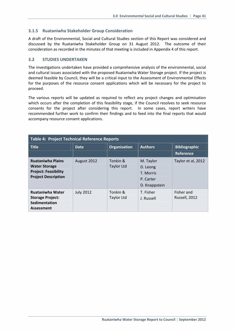
3.0 Environmental Social and Cultural Studies | Page 41
Ruataniwha Water Storage Report to Council | September 2012
3.1.5 Ruataniwha Stakeholder Group Consideration
A draft of the Environmental, Social and Cultural Studies section of this Report was considered and discussed by the Ruataniwha Stakeholder Group on 31 August 2012. The outcome of their consideration as recorded in the minutes of that meeting is included in Appendix 4 of this report.
3.2 STUDIES UNDERTAKEN
The investigations undertaken have provided a comprehensive analysis of the environmental, social and cultural issues associated with the proposed Ruataniwha Water Storage project. If the project is deemed feasible by Council, they will be a critical input to the Assessment of Environmental Effects for the purposes of the resource consent applications which will be necessary for the project to proceed.
The various reports will be updated as required to reflect any project changes and optimisation which occurs after the completion of this feasibility stage, if the Council resolves to seek resource consents for the project after considering this report. In some cases, report writers have recommended further work to confirm their findings and to feed into the final reports that would accompany resource consent applications.
Table 4: Project Technical Reference Reports
Title Date Organisation Authors Bibliographic
Reference
Ruataniwha Plains Water Storage Project: Feasibility Project Description
August 2012 Tonkin & Taylor Ltd
M. Taylor
D. Leong
T. Morris
P. Carter
D. Knappstein
Taylor et al, 2012
Ruataniwha Water Storage Project: Sedimentation Assessment
July 2012 Tonkin & Taylor Ltd
T. Fisher
J. Russell
Fisher and Russell, 2012

3.0 Environmental Social and Cultural Studies | Page 42
Ruataniwha Water Storage Report to Council | September 2012
Table 5: Modelling Studies
Title Date Organisation Authors Bibliographic Reference
Ruataniwha Plains Water Storage Project: Characterisation of Reservoir Water Quality
July 2012 NIWA M. Gibbs
C. McBride
D. Ozkundakci
D. Hamilton
Gibbs et al, 2012
Ruataniwha Water Storage Project: Tukituki River Catchment Assessment of Potential Effects on Groundwater and Surface Water Resources
June 2012 HBRC R. Waldron
H. Baalousha
Waldron and Baalousha, 2012
Modelling the Effects of Land Use on Nutrients Entering the Tukituki River, Hawke’s Bay
August 2012
NIWA, AgResearch, Plant & Food Research, Macfarlane Rural Business Ltd
K. Rutherford
A. Mackay
A. Manderson
S. Green
B. Clothier
I. Power
H. Eaton
A. Nicholls
C. Lewis
A. Macfarlane
Rutherford et al, 2012
Table 6: Terrestrial Aquatic and Ecology Assessment Reports
Title Date Organisation Authors Bibliographic Reference
Hawke’s Bay Regional Council Ruataniwha Water Storage Project: Terrestrial Ecology Study Assessment of Ecological Effects
July 2012
Kessels & Associates Ltd
G. Kessels
B. Deichmann
P. Stewart
D. Riddell
M. Hasenbank
R. Clark
U. Brandes
Kessels et al, 2012
Ruataniwha Water Storage Project – Aquatic Ecology Assessment of Effects
August 2012
Cawthron Institute
R. Young
N. Berkett
R. Holmes
J. Hay
Young et al, 2012
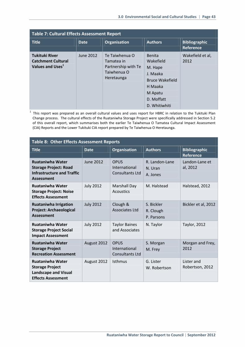
3.0 Environmental Social and Cultural Studies | Page 43
Ruataniwha Water Storage Report to Council | September 2012
Table 7: Cultural Effects Assessment Report
Title Date Organisation Authors Bibliographic Reference
Tukituki River Catchment Cultural Values and Uses1
June 2012 Te Taiwhenua O Tamatea in Partnership with Te Taiwhenua O Heretaunga
Benita Wakefield
M. Hape
J. Maaka
Bruce Wakefield
H Maaka
M Apatu
D. Moffatt
D. Whitiwhiti
Wakefield et al, 2012
1 This report was prepared as an overall cultural values and uses report for HBRC in relation to the Tukituki Plan Change process. The cultural effects of the Ruataniwha Storage Project were specifically addressed in Section 5.2 of this overall report, which summarises both the earlier Te Taiwhenua O Tamatea Cultural Impact Assessment (CIA) Reports and the Lower Tukituki CIA report prepared by Te Taiwhenua O Heretaunga.
Table 8: Other Effects Assessment Reports
Title Date Organisation Authors Bibliographic Reference
Ruataniwha Water Storage Project: Road Infrastructure and Traffic Assessment
June 2012 OPUS International Consultants Ltd
R. Landon-Lane
N. Uran
A. Jones
Landon-Lane et al, 2012
Ruataniwha Water Storage Project: Noise Effects Assessment
July 2012 Marshall Day Acoustics
M. Halstead Halstead, 2012
Ruataniwha Irrigation Project: Archaeological Assessment
July 2012 Clough & Associates Ltd
S. Bickler
R. Clough
P. Parsons
Bickler et al, 2012
Ruataniwha Water Storage Project Social Impact Assessment
July 2012 Taylor Baines and Associates
N. Taylor Taylor, 2012
Ruataniwha Water Storage Project Recreation Assessment
August 2012 OPUS International Consultants Ltd
S. Morgan
M. Frey
Morgan and Frey, 2012
Ruataniwha Water Storage Project Landscape and Visual Effects Assessment
August 2012 Isthmus G. Lister
W. Robertson
Lister and Robertson, 2012

3.0 Environmental Social and Cultural Studies | Page 44
Ruataniwha Water Storage Report to Council | September 2012
Table 9: Integrated Mitigation and Offset Report
Title Date Organisation Authors Bibliographic Reference
Ruataniwha Water Storage Project: Proposed Integrated Mitigation and Offset Approach
August 2012 Hawke’s Bay Regional Council
L. Coubrough
G. Hansen
S. Daysh
G. Kessels
Coubrough et al, 2012
Table 10: Land use Intensification Working Party Report
Title Date Organisation Authors Bibliographic Reference
Ruataniwha Plains Water Storage Project: Land Use Intensification Working Party Report
August 2012 Environmental Management Services Ltd
S. Daysh Daysh, 2012
3.3 FEASIBILITY PROJECT DESCRIPTION
As discussed above, the Tonkin & Taylor Ltd Feasibility Project Description report was developed in two stages to provide the key base information for the modelling and assessment reports. An Initial Project Description was prepared in November 2011 to enable the key environmental assessment work to get underway while engineering investigations continued. The report provided an overview of the project including key design and operating parameters and described how construction would be managed. The report was then finalised with reference to the initial drafts of the environmental investigations.
For the purposes of environmental effects assessment, the key elements of the project are:
Construction of a large in-river dam on the Makaroro River;
Conversion of an upper catchment riverine environment into a lacustrine environment;
Flooding of a substantial area of land, including an area of native bush;
Creation of a barrier to upstream and downstream aquatic migration patterns;
Alteration of the flow regime from the dam site downstream;
Construction of a water intake on the banks of the Waipawa River with a water distribution network spreading laterally across the Ruataniwha Plains;
Land use changes resulting from the use of irrigation water, causing increases in nutrient outputs both from irrigated areas and non-irrigated areas.
3.4 MODELLING REPORTS
3.4.1 Reservoir Water Quality Modelling
The scenarios modelled for this supplementary desktop study indicate that a broad range of water qualities in the reservoir and discharged from the reservoir are possible. The highest water quality

3.0 Environmental Social and Cultural Studies | Page 45
Ruataniwha Water Storage Report to Council | September 2012
would be associated with scenario M1 which would have all water drawn from an elevation of 405mRL. This scenario is likely to provide high quality water, which would be, on average, better than the inflow water from the Makaroro River. The water in the reservoir would be well oxygenated and suitable for aquatic life except in a small (<0.25% of the total volume of the reservoir when full) dead zone below the outtake level; although short periods of low dissolved oxygen concentration (<2gm3) would be possible without aeration under base flow conditions at the end of the stratified period. An aeration system should be installed in the reservoir as described in section 6.1 of the report to maintain bottom water DO levels above the minimum needed for fish and to accommodate the extreme events observed in other years, but not used in the simulations.
An aeration-style energy dissipation device below the discharge point from the reservoir would prevent river bed scour and boost DO levels in the Makaroro River below the reservoir.
Scenarios that included base flow draw from the toe of the dam also provided water quality better than the inflow water quality but would require aeration during the base flow only discharge period during summer stratification. The initial modelling scenario and scenario M3 demonstrated the use of a dual draw from 395 plus 426mRL and 405mRL plus 443mRL, respectively, where the outflow water was nearly always well oxygenated. However, if low water levels prevented discharge from the 426 or 443mRL outtake valves, the discharge water from the low level outtake valve would become anoxic. In these scenarios (initial and M3) the upper water column would remain well oxygenated and capable of supporting aquatic life. However, the available volume of habitable water would be small until natural thermal stratification isolated a surface mixed-zone layer. If the base flow from the reservoir was drawn from the 426mRL or 443mRL outtake valve as an outflow = inflow discharge, the downstream water would also be well oxygenated although warmer than the inflow and with elevated nutrients and phytoplankton biomass due to a surface skimming effect. If phytoplankton biomass was high, the pH would also rise. For the initial and M3 scenarios to operate efficiently, aeration would be needed during the summer stratified period.
The worst water quality came from scenarios where the outtake valves were high in the water column and there was no base flow discharge from the bottom of the dam. These scenarios, with all discharge water being taken from an elevation of either 426 or 443mRL, produced semi-permanent stratification with the water below the draw depth becoming anoxic and enriched with ammonium-N and phosphate. With the potential for summer water levels to fall to near the draw depth in these scenarios, the reservoir water quality would not be suitable for aquatic life in summer without the use of aeration.
Although there are benefits to removing the vegetation in the reservoir extent before filling, the cost would be high and valuable aquatic habitat diversity would be lost.
Because the reservoir water will be sensitive to nitrogen, catchment management to reduce or maintain low levels of nitrogen will be important. Managing sediment inputs would have the dual effect of reducing phosphorus loads in the lake bed and infilling of the reservoir with silt. Future-proofing the reservoir by providing 25m wide planted buffer zones between production forest land the reservoir are recommended, as is the construction of the necessary infrastructure required for forest harvesting before the reservoir is filled. Because the catchment land is susceptible to erosion and particularly slipping, management strategies designed to minimise bare land exposure will also be important. Land clearance of steep land within the reservoir catchment should be a discretionary action in the regional plan requiring a resource consent, and sediment control plans should be provided and approved before harvesting production forest.+
3.4.2 Groundwater / Surface Water Modelling
This study investigates the potential future impact of the proposed Ruataniwha Water Storage scheme on water resources in the Tukituki Catchment and Ruataniwha Basin.

3.0 Environmental Social and Cultural Studies | Page 46
Ruataniwha Water Storage Report to Council | September 2012
The Ruataniwha Plains (approximately 40,000 hectares) are located in central Hawke’s Bay overlying the Ruataniwha Basin and aquifer within the Tukituki River Catchment and have significant agricultural potential. However this is restricted by the ability to access water. Approximately 6000 hectares of the plains are currently irrigated, principally supplied by groundwater abstracted (pumped) from the Ruataniwha Aquifer. Water is also abstracted from the Tukituki River and its tributaries. Studies have identified an additional 22,550 hectares of potential irrigable land within the Ruataniwha Plains. However groundwater and surface water abstractions are considered to be fully allocated and as such, the provision of irrigation capacity from a potential community water storage scheme located on the Upper Makaroro River (a tributary of the Waipawa River which feeds into the Tukituki River) is being investigated.
The purpose of this study was to predict and compare the potential future impact of four different water resource management scenarios which incorporate different levels of water abstraction, with and without the operation of the proposed water storage scheme, on the Ruataniwha Aquifer System and river flow regimes within the Tukituki River Catchment.
Four scenarios were considered:
1) Natural system (no consented water abstraction or storage scheme in place)
2) Current (actual) water abstraction continues up to the end of 2016
3) Proposed water storage scheme in operation from 2017 to 2022 while consented water abstraction is discontinued from 2017
4) Proposed water storage scheme in operation from 2017 in combination with consented water abstraction continuing to 2022
A transient groundwater model developed by the Hawke’s Bay Regional Council was used to simulate changes to the aquifer system in terms of aquifer storage, aquifer-spring interactions and aquifer-river interactions.
The change in aquifer contribution to river flows within the Ruataniwha Basin and change to river flow regimes were also simulated under each of the four scenarios at three river flow sites; Tukituki River at Tapairu Rd, Waipawa River at RDS and Tukituki River at Red Bridge.
Scenarios incorporating the water storage scheme (Scenarios 3 & 4) were compared to Scenario 2 which represents the effect of ‘current abstraction’ on the resource simulated to the end of 2016 prior to the start of the scheme in 2017. Scenario 2 was also compared to Scenario 1 which represents the ‘natural state’. The relative change to aquifer storage modelled under each scenario is graphically depicted in the following figure.

3.0 Environmental Social and Cultural Studies | Page 47
Ruataniwha Water Storage Report to Council | September 2012
Figure 8: Relative Changes to Aquifer Storage Under Each Scenario
The Scenario 3 simulation compared to Scenario 2, predicts a significant recovery in Ruataniwha Aquifer storage by 2022 (32 MCM) with spring flow returning to near natural levels as a result of ceasing all abstraction within the basin.
Scenario 4, predicts a decline in aquifer storage, spring flow and aquifer contribution to river flow similar to that predicted under Scenario 2.
The aquifer system is predicted to be close to a state of dynamic-equilibrium from 2017 to 2022 under Scenarios 2 and 4, which means that only minimal changes in aquifer storage would be expected after 2022 based on the assumed conditions. At the end of the simulation period for Scenario 4 (31-Dec-2022) the total predicted storage loss from natural conditions was 68 MCM.
The predicted decline in spring flow in Scenario 4 over the last 12 years compared to the first five years is approximately 60 l/s, which is similar to the decrease predicted in spring flow at the end of the simulation for Scenario 2.
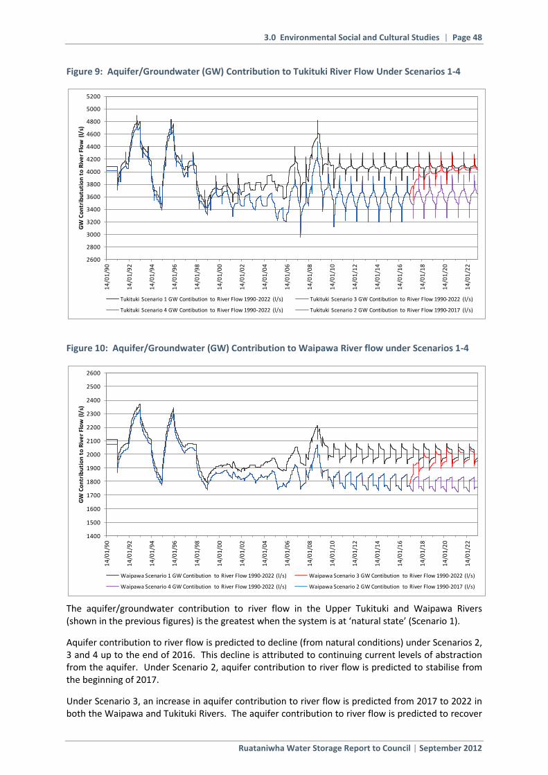
3.0 Environmental Social and Cultural Studies | Page 48
Ruataniwha Water Storage Report to Council | September 2012
Figure 9: Aquifer/Groundwater (GW) Contribution to Tukituki River Flow Under Scenarios 1-4
Figure 10: Aquifer/Groundwater (GW) Contribution to Waipawa River flow under Scenarios 1-4
The aquifer/groundwater contribution to river flow in the Upper Tukituki and Waipawa Rivers (shown in the previous figures) is the greatest when the system is at ‘natural state’ (Scenario 1).
Aquifer contribution to river flow is predicted to decline (from natural conditions) under Scenarios 2, 3 and 4 up to the end of 2016. This decline is attributed to continuing current levels of abstraction from the aquifer. Under Scenario 2, aquifer contribution to river flow is predicted to stabilise from the beginning of 2017.
Under Scenario 3, an increase in aquifer contribution to river flow is predicted from 2017 to 2022 in both the Waipawa and Tukituki Rivers. The aquifer contribution to river flow is predicted to recover
2600
2800
3000
3200
3400
3600
3800
4000
4200
4400
4600
4800
5000
5200
14
/01
/90
14
/01
/92
14
/01
/94
14
/01
/96
14
/01
/98
14
/01
/00
14
/01
/02
14
/01
/04
14
/01
/06
14
/01
/08
14
/01
/10
14
/01
/12
14
/01
/14
14
/01
/16
14
/01
/18
14
/01
/20
14
/01
/22
GW
Co
ntr
ibu
tuti
on
to
Riv
er
Flo
w (
l/s)
Tukituki Scenario 1 GW Contibution to River Flow 1990-2022 (l/s) Tukituki Scenario 3 GW Contibution to River Flow 1990-2022 (l/s)
Tukituki Scenario 4 GW Contibution to River Flow 1990-2022 (l/s) Tukituki Scenario 2 GW Contibution to River Flow 1990-2017 (l/s)
1400
1500
1600
1700
1800
1900
2000
2100
2200
2300
2400
2500
2600
14
/01
/90
14
/01
/92
14
/01
/94
14
/01
/96
14
/01
/98
14
/01
/00
14
/01
/02
14
/01
/04
14
/01
/06
14
/01
/08
14
/01
/10
14
/01
/12
14
/01
/14
14
/01
/16
14
/01
/18
14
/01
/20
14
/01
/22
GW
Co
ntr
ibu
tio
n t
o R
ive
r Fl
ow
(l/
s)
Waipawa Scenario 1 GW Contibution to River Flow 1990-2022 (l/s) Waipawa Scenario 3 GW Contibution to River Flow 1990-2022 (l/s)
Waipawa Scenario 4 GW Contibution to River Flow 1990-2022 (l/s) Waipawa Scenario 2 GW Contibution to River Flow 1990-2017 (l/s)

3.0 Environmental Social and Cultural Studies | Page 49
Ruataniwha Water Storage Report to Council | September 2012
to near natural conditions at the end of the simulation period in 2022 with only minor further changes expected after that time.
Under Scenario 4, a minor further decline in the aquifer contribution to the Waipawa River and a minor recovery in the groundwater contribution to the Tukituki River are predicted from 2017.
Table 11: Summary of Modelled River Flow Statistics
* Days per year averaged over the modelled river flow record
The ‘proposed minimum flows’ referred to in the above table have been developed for the pending Tukituki Catchment Resource Management Plan Change as a result of work undertaken by the HBRC. The proposed minimum flows for the Tukituki River at Tapairu Rd and Waipawa River at RDS are based on a flow predicted to provide 90% habitat protection available at the mean annual low flow (MALF) for juvenile longfin eel. The proposed minimum flow for the Tukituki River at Red Bridge is based on a flow predicted to provide 90% habitat protection available at the MALF for adult rainbow trout. These minimum flows have yet to be formally adopted by the HBRC at the date of writing this report.
The above table summarises changes to modelled river flow statistics from which the following comparisons have been made.
The proposed water storage scheme will not involve any abstraction or retention of water from the Tukituki River upstream of the confluence with the Waipawa River. Modelling results therefore predicted that discontinuing groundwater and surface water abstractions from 2017 and migrating them to the storage scheme under Scenario 3, would have a positive impact on river flows in the Tukituki River at Tapairu Rd, predicting that river flows would return to near natural conditions (Scenario 1) by 2022.
Migrating all current groundwater and surface water abstractions to the storage scheme under Scenario 3 is predicted to result in some significant gains for rivers at low flow conditions compared to Scenario 2 (under which current abstraction continues). The greatest change to key low flow statistics is predicted in the Q99 statistic (flow that is equalled or exceeded for 99% of the time), which increased between 24% and 44% at all three river sites. Under Scenario 3, the MALF was predicted to increase by 28% in the Tukituki River at Tapairu Rd, by 5% in the Waipawa River at RDS
Scenario 2
(2016)
Continuation of
Current Abstraction
Tukituki River at Tapairu Rd 8912 l/s +6% (9433 l/s) +0.4% (8949 l/s)
Waipawa River at RDS 8452 l/s -22% (6587 l/s) -25% (6308 l/s)
Tukituki River at Red Bridge 20657 l/s -5% (19526 l/s) -9% (18717 l/s)
Tukituki River at Tapairu Rd 15091 l/s +4% (15631 l/s) +0.3% (15129 l/s)
Waipawa River at RDS 14636 l/s -14% (12535 l/s) -16% (12257 l/s)
Tukituki River at Red Bridge 43224 l/s -3% (41715 l/s) -5% (40891 l/s)
Tukituki River at Tapairu Rd 1220 l/s +44% (1754 l/s) +3% (1260 l/s)
Waipawa River at RDS 1864 l/s +24% (2316 l/s) +13% (2102 l/s)
Tukituki River at Red Bridge 3577 l/s +27% (4532 l/s) +7% (3814 l/s)
Tukituki River at Tapairu Rd 2161 l/s +28% (2772 l/s) +2% (2205 l/s)
Waipawa River at RDS 2654 l/s +5% (2794 l/s) -6% (2495 l/s)
Tukituki River at Red Bridge 5256 l/s +15% (6055 l/s) -2% (5150 l/s)
Tukituki River at Tapairu Rd (2300 l/s) 33 days -15 days (18 days) No Change (33 days)
Waipawa River at RDS (2500 l/s) 26 days -11 days (15 days) +7 days (33 days)
Tukituki River at Red Bridge (5200 l/s) 26 days -15 days (11 days) +3 days (29 days)
Scenario 3 Scenario 4
Median
(2022) (2022)
Change from
Scenario 2
Change from
Scenario 2
River Flow SiteRiver Flow Statistic
Lo
w F
low
Ran
ge
Mid
Flo
w R
ang
e
Days ≤ Proposed
Minimum Flow *
(l/s)
MALF
Q99
Mean

3.0 Environmental Social and Cultural Studies | Page 50
Ruataniwha Water Storage Report to Council | September 2012
and by 15% in the Tukituki River at Red Bridge. As a point of reference, the lowest recorded flow was predicted to increase by 78% in the Tukituki River at Tapairu Rd, by 91% in the Waipawa River at RDS and by 70% in the Tukituki River at Red Bridge.
At Waipawa River at RDS the Q99 increased by 24% to a flow higher than that modelled under natural flows in Scenario 1. This is attributed to low flows being augmented by the residual flow discharged from the storage dam. The Q99 increased by 44% at Tukituki River at Tapairu Rd, a result of river flows in the Upper Tukituki Catchment returning near to natural conditions. In the Lower Tukituki River at Red Bridge, Q99 also increased (by 27%) to a flow higher than that modelled under natural conditions which is attributed to a cumulative effect of Upper Tukituki River flows returning to natural conditions and Waipawa River flows being augmented by the storage dam residual flow.
Modelling results predict that Scenario 3 would reduce mid to high range flow statistics in the Waipawa and Lower Tukituki Rivers (for example, reducing median flow in the Waipawa River at RDS by 22% and by 5% in the Tukituki River at Red Bridge). The reduction in mid to high range flows reflects the effect of the dam intercepting and storing Makaroro River flows, discharging a residual flow and releasing flow for subsequent abstraction downstream for irrigation. Mid to high range flows are predicted to increase in the Upper Tukituki River due to not being directly affected by the scheme.
In comparison to Scenario 2, a significant decrease in days where river flow is less than or equal to the proposed minimum flow is predicted at all sites under Scenario 3. At each site, days less than or equal to the proposed minimum flow are predicted to return to that shown in the natural flow regime under Scenario 1; a reduction of 15 days at Tukituki River at Tapairu Rd and Tukituki River at Red Bridge, and a reduction of 11 days at Waipawa River at RDS.
Continuing current groundwater and surface water abstraction in combination with operating the water storage scheme under Scenario 4, predicts an increase in the Q99 low flow statistic from Scenario 2 at Waipawa River at RDS of 13% and 7% at Tukituki River at Red Bridge. Again as a point of reference, the lowest recorded flow was predicted to increase by 71% in the Waipawa River at RDS and by 37% in the Tukituki River at Red Bridge. These increases are attributed to residual flows provided by the scheme during periods of low flow conditions. However this scenario is not predicted to provide significant benefits to any other flow statistics. In the Waipawa and Lower Tukituki Rivers, Scenario 4 is predicted to result in further reductions in all other flow statistics from Scenario 2. Reductions in mid to high flows ranged between 14% and 25% at Waipawa River at RDS and between 4% and 9% at Tukituki River at Red Bridge. These are slightly higher reductions than that modelled under Scenario 3 which reflects the effect of water abstractions continuing in combination with the dam intercepting and storing Makaroro River flows.
Minimal change was predicted in the flow regime at Tukituki River at Tapairu Rd under Scenario 4 from that of the river flow regime modelled under Scenario 2. Scenario 4 predicted a minor increase in low flow statistics (no more than 3%) which is attributed to the stabilisation of the Ruataniwha Aquifer System over time.
When comparing Scenarios 2 and 4, in terms of predicted days where river flow is less than or equal to the proposed minimum flow, Scenario 4 showed an increase of 7 days from Scenario 2 at Waipawa River at RDS, an increase 3 days at Tukituki River at Red Bridge, whereas no change was predicted at Tukituki River at Tapairu Rd.
Operating the water storage scheme after discontinuing all current abstraction under Scenario 3 predicted:
a) A lower overall impact on river flows in the Waipawa and Lower Tukituki Rivers than if current abstractions continued in conjunction with the water storage scheme in operation under Scenario 4.

3.0 Environmental Social and Cultural Studies | Page 51
Ruataniwha Water Storage Report to Council | September 2012
b) An increase in low flow statistics towards natural conditions in all rivers.
c) A higher impact on mid to high range flows in the Waipawa and Lower Tukituki Rivers than if only current abstraction continued under Scenario 2.
d) Upper Tukituki River flows would return to near natural conditions throughout the full range of the flow regime.
For each site, scenario-modelled daily mean flow records have been produced. These are available from the Hawke’s Bay Regional Council on request.
The scenarios modelled in this report were designed to predict relative changes to a complex dynamic system when changes are made to various input parameters. Some future predictive input parameters were averaged from historical records. An additional margin of uncertainty was introduced by strong reliance on literature values for input parameters where measured data was not readily available.
In addition, modelling current levels of surface water abstraction on river flow records used estimates of actual water use throughout a typical year. These estimates were based on available metered actual water use data. The available metered data for the Tukituki Catchment was limited to 2007-2008. In the absence of additional metered data, it was assumed that 2007-2008 represented a typical year of surface water abstraction in the Tukituki Catchment. Groundwater abstraction estimates used in the transient groundwater model were based on crop water demand studies and available metered well data.
In view of the previous statements, modelling results in this study should principally be used for making comparisons between scenarios rather than identifying absolute changes or making comparisons with actual values.
3.4.3 Land Use Intensification Modelling
The Hawkes Bay Regional Council (HBRC) requires an assessment to be made of the likely impacts of the proposed Ruataniwha irrigation scheme on nutrient inputs to the Tukituki River, and the resultant impacts on aquatic plants. A multi Crown Research Institute (CRI) approach has been used to model the current and expected nutrient loss into the Tukituki River, as a result of land use intensification. The agencies and experts involved in this process include:
Dr Steve Green and Dr Brent Clothier; Plant and Food Research (PFR)
Dr Alec Mackay and Dr Andrew Manderson; AgResearch
Dr Kit Rutherford; NIWA
Input assumptions to the model were developed through the On-Farm Economic Study (2011) by MacFarlane Rural Business Ltd. This included the predicted future land use and farm management practices.
The purpose of the nutrient modelling has been to determine:
Current nutrient loss from farms, through the SPASMO model
Potential nutrient loss from a likely change in land use through the SPASMO model
The extent of current and potential nutrients reaching surface water as a result of farm land nutrient losses and the resulting effects on water quality, through the NIWA land use model, and on nutrient transformations and biomass growth, through the NIWA stream model.
Mitigation options to avoid or minimise effect of land use on surface water through the OVERSEER model.
3.0 Environmental Social and Cultural Studies | Page 52
Ruataniwha Water Storage Report to Council | September 2012
This report details the development and calibration by NIWA of a model of nutrient loss (the ‘land use model’) from the Ruataniwha Basin to the Waipawa and Tukituki rivers. The land use model predicts soluble nitrogen (N) and total phosphorus (P) losses, but does not predict particulate nitrogen losses. A conceptual model for nutrient, rather than a process-based model, is considered suitable for this project given its aims and the information available.
The land use model considers the spatial distribution of land use across an area of 80,500 ha, which includes 31,870 ha of land (Zones A, B, C and D – the irrigation command area) assessed as potentially suitable for irrigation7 and an additional 45,800 ha (Zone X – the upstream area within the model area) which overlies the Ruataniwha aquifer and may undergo land use change to support farming enterprises in the irrigation area. The land use model predicts annual average N and P loads and yields in the Tukituki and Waipawa rivers near Waipukurau and Waipawa, taking account of groundwater travel times and nutrient attenuation.
Three scenarios of land use are modelled in detail: Scenarios A, B and C.
Scenario A represents current land uses and models the movement and attenuation of N and P estimated (from the SPASMO modelling process described in Appendix 1) to be lost from land via surface runoff and sub-surface groundwater pathways into surface water bodies. Scenario A is intended to provide a baseline scenario capturing current nutrient loadings to the catchment and the resulting aquatic plant growth, against which the impact of land intensification utilising water stored as part of the Ruataniwha Storage Scheme might be assessed.
The land use model was ‘calibrated’ for current land use by adjusting three key model coefficients – drainage, attenuation and groundwater travel time – to match observed stream nutrient loads in the Tukituki River at Waipukurau and the Waipawa River at Waipawa from 2004-2009. Model calibration and sensitivity analysis indicate that a similar goodness of fit can be obtained using several combinations of the key model coefficients. The choice of coefficients used for prediction is guided not just by goodness of fit, but also by other information from the Ruataniwha and similar studies elsewhere.
After calibration to measured N and P loads in the Tukituki River at Waipukurau, predicted annual yields in the Waipawa River at Waipawa match important features of observed 1994-2009 yields including average yield and year-to-year variations driven by climate. The land use model is considered to be sufficiently accurate to predict the likely impact of the proposed irrigation scheme on annual nutrient exports at the basin outlet.
The outputs of the land use model (expressed as nutrient yields downstream from the irrigation area) are used as inputs to the ‘stream model’ which predicts nutrient concentrations and aquatic plant biomass in the Tukituki River below the townships of Waipukurau and Waipawa.
For Scenario A, Macfarlane Rural Business Ltd provided farm production and management information to PFR for input into the SPASMO modelling. Macfarlane Rural Business Ltd assumed ‘average’ performance with farming practices and associated nutrient losses typical of current farms. If farms currently lose more nutrient than is calculated by SPASMO assuming ‘average’ performance, then the calibrated attenuation coefficients will be under-estimated. This means that for Scenarios B and C, predicted stream loads will be over-estimated, the actual nutrient concentrations and consequent effects on ecosystem ‘health’ are likely to be less significant than the predictions, and hence there is a ‘margin of safety’ in the modelling. If farms currently lose less nutrient than is predicted by SPASMO assuming ‘average’ performance, then the converse applies but this is not considered to be likely.
7 The revised Macfarlane Rural Business Ltd report (currently in press) assumes an irrigable area of 22,500 ha. HBRC is
considering some modifications to the area of land modelled. It is recommended that the land use model be re-run once the final irrigation area and area of influence have been resolved.

3.0 Environmental Social and Cultural Studies | Page 53
Ruataniwha Water Storage Report to Council | September 2012
The second scenario (Scenario B) models modified land uses resulting from the availability of irrigation water from the Storage Scheme across the irrigation area. The nature and extent of modified land uses reflects advice from Macfarlane Rural Business Ltd as to what land use changes might realistically be expected on irrigated farmland (refer to Appendix 1). N and P losses from those modified land uses have been calculated by PFR using the SPASMO model. The purpose of Scenario B is to quantify the likely increase in nutrient losses to the Tukituki catchment resulting from land intensification associated with the Storage Scheme and the consequent effect on aquatic plant growth. For Scenario B Macfarlane Rural Business Ltd provided production and management information to PFR assuming that the ‘top 20%’ of farmers would be operating after the Storage Scheme is implemented (compared with ‘average’ performance assumed for Scenario A). Scenario B assumes that land use does not change in Zone X. In the irrigation area it assumes: fenced and destocked waterways, no fertiliser spread in waterways, nitrogen applied at a rate that can be taken up by pastures and crops, fertiliser applications made according to a nutrient budget, careful cultivation to minimise soil loss by erosion and to reduce the breakdown of organic matter, careful grazing management to minimise pugging and runoff, and irrigation management to maintain growth but minimise leaching.
Because the level of nutrients and aquatic plant growth in the Tukituki catchment below Waipukurau and Waipawa is affected by discharges from the municipal wastewater facilities servicing those communities, which are the subject of plans to reduce contaminant levels, the stream model for Scenario B has two sub-scenarios, one assuming continuation of those wastewater discharges and one assuming they reduce.
Using data supplied by PFR and AgResearch, the land use model indicates that, comparing Scenario B (irrigation and ‘top 20%’ performance) with Scenario A (current land use and ‘average’ performance):
N losses from the model area increase from 2,440 to 3,060 t y-1 (25%).
P losses from the model area increase from 67 to 80 t P y-1 (20%).
The model area encompasses Zones A-D and X but land use change is assumed to change only in Zones A-D. N and P loads leaving the Ruataniwha Basin increase by lower percentages than losses from the irrigation area because of dilution from upstream and attenuation.
N loads leaving the Ruataniwha Basin increase from 1,320 t y-1 to 1,615 t y-1 (22%).
P loads leaving the Ruataniwha Basin increase from 57 t y-1 to 63 y t-1 (10%).
In a separate analysis the implications of extending dairy and intensive arable by a further 5,450 ha and reducing sheep and beef extensive, orchard and vineyard by the corresponding area translated to an increase in total N losses of 101 t y-1 compared with Scenario B.
The third scenario (Scenario C) tests the potential benefits of reducing N losses from a selection of land uses under the irrigated Scenario B by adopting specific mitigation actions to reduce N losses. Intensive arable and process vegetable cultivation and dairying were chosen to be the subject of this scenario because they represent a significant proportion of the assumed land uses in the irrigation area under Scenario B, and because they produce relatively high levels of N losses. Macfarlane Rural Business Ltd has advised what on-farm mitigation options might realistically be employed (described in Appendix 3) which include the actions listed for Scenario B plus: application of nitrification inhibitors, reduction in nitrogen fertiliser use, reduction or removal of high nitrogen loss crops such as potatoes and squash, reduction in grazing time on pasture in order to reduce the number of urine patches, substitution of pasture with other feeds such as grain or silage, holding stock off pasture on feed pads to collect dung and urine for more even distribution, and reduced lactation periods to allow destocking by grazing off on support farms. AgResearch calculated, using the OVERSEER model, the effect of adopting a suite of mitigation practices on the level of nitrogen losses from the

3.0 Environmental Social and Cultural Studies | Page 54
Ruataniwha Water Storage Report to Council | September 2012
intensive arable and dairy systems. A reduction of 16 kg ha-1 (for intensive arable/process vegetable cultivation) and 21 kg ha-1 (for dairying on light soils) was required to reduce the N leaching losses for both land uses to 30kgN/ha/yr. The methodology employed is described in more detail in Appendix 4. The purpose of Scenario C is to provide an initial indication of the sensitivity of the predicted effects of land intensification on water quality to an on-farm N leaching limit. Mitigation of N losses may, or may not, be required depending on the N guidelines adopted to protect downstream water quality and ecosystem ‘health’. Comparing Scenario C (irrigation with N mitigation to an on-farm limit for two land uses) with Scenario B (irrigation and ‘top 20%’ performance), N mitigation measures reduce N losses by 9%.
Comparing Scenario C with Scenario A (current land use):
N losses from the model area increase from 2,440 to 2,780 t y-1 (14%).
N loads leaving the Ruataniwha Basin increase from 1,320 t y-1 to 1,480 t y-1 (12%).
Again, the model area encompasses Zones A-D and X but land use change only occurs in Zones A-D.
If we assume 10, 20 or 50% (extreme) of the extensive sheep and beef operations (22,018ha) in Zone X (45,802ha) shift enterprises to include wintering dairy cows and contract heifer grazing, the increase in total N losses in Zone X would amount to 1.04, 2.1 and 5.2 t y-1, respectively, This is a small increase in N loss from the zone and an insignificant amount compared with the N loads leaving the Ruataniwha Basin. The corresponding increases in total P losses in Zone X, again assuming 10, 20 or 50% (extreme) of the extensive sheep and beef operations in Zone X shift enterprises to include wintering dairy cows and contract heifer grazing, would amount to 23, 46 and 116 kg P y-1, respectively. These increases are again very small.
Work is on-going to refine the assessments reported here, and further scenarios will be modelled to assess the effects on nutrient losses and consequential downstream effects of: mitigating both N and P losses, a wider range of modified land uses and changing the mix of land uses modelled.
An existing mechanistic model of stream nutrient dynamics and aquatic plant growth (the ‘stream model’) is applied in the lower Tukituki River between Waipukurau and the sea. The model is used to assess the effect of the Storage Scheme and Waste Water Treatment Plant (WWTP) discharges in the lower Tukituki River downstream from the townships of Waipukurau and Waipawa. It is also used to estimate the effects of the Storage Scheme on nitrate concentrations to enable an assessment of the risks to stream ecosystem ‘health’ posed by nitrate toxicity once revised nitrate toxicity guidelines become available. The majority of reported problems with high periphyton biomass occur in the lower Tukituki River downstream from the townships of Waipukurau and Waipawa, although there may be some ‘hot spots’ in streams within the Ruataniwha Basin, where high nitrate concentrations and/or high plant biomass occur.
Daily nutrient concentrations are estimated from annual yields using the available monitoring data, to provide input data for the stream model. The estimated daily concentrations match the observed variations of concentration with flow and time, and furnish estimates of annual nutrient yield that compare favourably with published estimates.
Predicted nutrient concentrations account for the reduced dilution of nutrient losses arising from likely flow changes. Scenarios B and C make the ‘worst case’ assumption that surface and groundwater abstractions continue at current levels after irrigation starts. Data supplied by HBRC indicate that the irrigation scheme will decrease average river flows, notably in the Waipawa River, although it will increase summer low flows.
A possible guideline, derived from a review of (mostly overseas) published nitrate toxicity studies is 1.7 g NO3N m-3 quoted as providing protection for 95% of species. The percentage of days when this guideline is exceeded in the Tukituki River at Waipukurau increases from 18% (Scenario A) to 36%
3.0 Environmental Social and Cultural Studies | Page 55
Ruataniwha Water Storage Report to Council | September 2012
(Scenario B) and 29% (Scenario C). Work has recently been completed by NIWA to measure the susceptibility to nitrate of two keystone New Zealand freshwater organisms (one fish species (Galaxias maculatus (inanga)) and one mayfly Deleatidium sp.). That work, and other recent nitrate toxicity data, have not yet been incorporated into existing guidelines. There are indications, however, that the 1.7 g NO3N m-3 guideline may be conservative for the organisms tested and that a higher guideline may be acceptable, but this awaits confirmation.
The wastewater treatment plants (WWTP) at Waipukurau and Waipawa townships discharge large amounts of P compared to losses from the Ruataniwha Plain. In this report both land disposal and phosphorus stripping are modelled, as well as irrigation. The stream model predicts that there are likely to be significant beneficial effects, in terms of reduced DRP concentrations, reduced periphyton biomass and associated improvements in ecosystem ‘health’, from reducing P inputs from the WWTP discharges at Waipukurau and Waipawa.
Irrigation (Scenarios B and C) leads to higher peak biomasses than for current land use (Scenario A) in the vicinity of Waipukurau. If P inputs from the WWTPs are reduced as planned, then the highest biomass is predicted to occur at the top of the modelled reach (viz., in the vicinity of Waipukurau). Whereas the 10%ile biomass (viz., the biomass that is only exceeded 10% of the time) at SH2 currently averages 49 gC m-2, this is predicted to increase to 57 gC m-2 with irrigation because of increased P inputs. These simulations do not consider possible P loss mitigation measures which are currently being investigated.
There is uncertainty in model predictions of periphyton biomass arising from high variability in observed biomass used for calibration. In addition, spatial variability in bed stability, water depth and water velocity affect predicted periphyton biomass. There is also uncertainty arising from the omission of particulate N losses from the irrigation area. Consequently, the longitudinal profiles of predicted biomass presented here may not be quantitatively accurate. Nevertheless, they provide strong qualitative indications of the likely magnitude of change.
Further work is currently being undertaken to extend the model upstream from Waipukurau and Waipawa in order to assess the impact of irrigation and land use intensification within the Ruataniwha Plain, notably where groundwater upwelling occurs and ‘hot spots’ of N and P occur. This work will include modelling the effects of land use change outside the irrigation area, including land in the lower Tukituki River.
3.5 ECOLOGICAL EFFECTS ASSESSMENTS
3.5.1 Terrestrial Ecology
The Terrestrial Ecology Study is part of the wider Technical Feasibility and other scientific assessment studies that will provide the information for the resource consenting process for the proposed Ruataniwha Water Storage Project in Central Hawke’s Bay if the project is deemed feasible. Kessels & Associates have been engaged by Hawke’s Bay Regional Council to conduct an ecological impact assessment and make recommendations regarding measures to avoid, mitigate or offset potential adverse effects on indigenous terrestrial fauna and flora species and their habitats.
Potential Ecological Effects
The potential ecological effects of the construction and operation of the Ruataniwha Water Storage Project on terrestrial indigenous fauna and flora are:
A permanent loss of a variety of indigenous vegetation communities and braided river within the inundation, dam and spillway footprint area;
A permanent loss of a variety of feeding, roosting and breeding habitats (both exotic and indigenous) for birds, lizards, bats and invertebrates;
3.0 Environmental Social and Cultural Studies | Page 56
Ruataniwha Water Storage Report to Council | September 2012
Alteration of habitats for indigenous flora and fauna within and adjacent to braided river ecosystems downstream of the dam and intake structure associated with changes in sediment deposition rates, river flow patterns and changes in landuse; and
A change of habitat types on the margins of the reservoir due to changes in hydrology and effects of seasonal and irrigation drawdown causing inundation and ebbing of the ‘lake’ edge; and
Disturbance of remaining indigenous flora and fauna adjacent to the reservoir due to potential increases in the recreational use of the reservoir and its margins.
Assessments Undertaken
Field assessments have been undertaken over the period of September 2011 to February 2012 within, and over areas potentially affected by, the proposed Ruataniwha Water Storage Project. In addition, literature searches, data analysis, GIS mapping analysis and ecological significance determination have also been undertaken during this period. Specifically, the investigations have focussed on:
Field Investigations to ground truth and refine vegetation maps and to assess whether any at risk or threatened plants are in the affected areas;
Avifauna surveys to determine relative abundance of common indigenous and native birds and to assess whether any at risk and/or threatened birds utilise the affected areas;
Field investigations to confirm the level of importance of affected habitat for long-tailed bats;
Field investigations to confirm the importance of affected habitat for lizards, in particular to identify the presence or absence of at risk and threatened species;
Field investigations to confirm the importance of affected habitat for invertebrates, in particular to identify the presence or absence of at risk or threatened species;
An examination of the impact of habitat loss on functional landscape ecology values;
Potential effects of river morphology changes on terrestrial linked ecosystem values; and
Recommendations for appropriate measures to avoid, remedy, mitigate, or offset for any potential adverse effects identified.
Results of the Assessment
The total area affected by flooding, the dam structure and spoil disposal is approximately 450.21 ha. A third of this area (i.e. 38.7% or 174.24 ha) is covered in pasture or rank grasses, with the area classified as indigenous vegetation or habitats covering 242.4 ha8 (53.8%). The total area of terrestrial indigenous vegetation cover (which excludes wetlands, seepzones and gravel riverbed) is 163.23 ha (36%), in comparison to 204.90 ha (45%) of exotic vegetation cover (i.e. pasture and exotic forest and scrub). One At Risk plant species was found – red mistletoe.
A total of 37 bird species (11 endemic) were identified at the proposed reservoir locality during field surveys. Of these birds 55% were native and 45% introduced. Threatened or At Risk species comprise 2.3% of all observations, including one pair of the Nationally Vulnerable New Zealand bush falcon, which was most likely nesting in the site during spring. Nationally ‘At Risk’ species detected were pied stilt, New Zealand pipit, black shag and North Island fernbird.
8 NB: Includes all indigenous woody vegetation, wetland and seeps, as well as braided river and open stream channel
3.0 Environmental Social and Cultural Studies | Page 57
Ruataniwha Water Storage Report to Council | September 2012
Long-tailed bats were found throughout the proposed reservoir during an ultrasonic survey completed between November 2011 and February 2012. Simultaneous surveys of the inundation area and wider landscape showed that it is likely that bats are resident and roosting within the inundation area, and then move out into the wider landscape throughout the night. Activity levels are higher within the inundation zone when compared to the wider landscape demonstrating the importance of this habitat for the bats.
Eleven lizard species are known from the southern Hawke’s Bay region or neighbouring areas of the southern North Island. However, only one lizard was found during the field survey. This was a southern North Island forest gecko. It is not classified as being a nationally At Risk or Threatened species.
Targeted rapid surveys for terrestrial invertebrates were undertaken within the proposed reservoir site in December 2011 and again in January 2012. In addition, passive detection devices have been deployed and checked throughout the site from November 2011 until February 2012. Results showed a rich diversity of insects and land snails. However, to date, no terrestrial invertebrates listed as rare, or threatened have been discovered.
A total of 182.52 ha of ecologically significant indigenous vegetation and habitats would be flooded by the proposed reservoir. This comprises of: 80.72 ha of mature and secondary indigenous forest; 22.71 ha of secondary indigenous scrub; 73.97 ha of gravel river bed; and 5.11 ha of wetland or seepzones.
Suggested Approach for the Effects Identified
A number of measures are required to avoid or remedy potential adverse effects on terrestrial ecology. These include:
A two year pre-construction bat survey to determine the size of the resident bat population; its roosting sites and movement patterns across the landscape;
A bat management plan pending the results of the two year survey;
A pre-construction lizard survey and translocation plan;
A weed hygiene and surveillance plan; and
Post-construction monitoring of key wader bird species within affected braided river habitat and contingency habitat enhancement if adverse effects are shown to occur.
In addition to measures to avoid, remedy or directly mitigate for potentially affected flora and fauna, three broad biodiversity restoration and enhancement packages are recommended. These are:
A: Ruataniwha Reservoir Restoration Buffer and Catchment Enhancement Zone
The objectives of this package are to:
Recreate 46 ha of riparian margin with indigenous vegetation, which will provide habitats and ecological linkages for a wide range of fauna and flora.
Restore and enhance at least 100 ha of marginal farmland and existing forest, scrub, treeland, shrubland and wetland remnants within the sub-catchment above the dam to quickly improve existing habitat for flora and fauna, reinforce ecological linkages within the landscape and provide refuge for species during and after the flooding process.
B: Ruataniwha Riparian Enhancement Zone
The objectives for this package are to:
3.0 Environmental Social and Cultural Studies | Page 58
Ruataniwha Water Storage Report to Council | September 2012
Control of willows/lupins and other braided river weeds to maintain and enhance habitat for wading birds, particularly banded dotterel, within the Waipawa and Makaroro Rivers. This may also include fencing and restoring margins of the main stems of the two rivers where required, in consultation with adjoining landowners. The primary target area for these works would be high quality wading bird habitat.
Carry out ongoing animal pest control over the 616 ha of existing bush, scrub and wetland habitats within the zone, targeting possums and rats.
Assist landowners with fencing, replanting (as required) and legally protecting existing areas of wetlands, bush and scrub within or contiguous with the 1 km enhancement zone.
C: Ruataniwha Threatened Species Habitat Enhancement:
Its objectives are to:
Instigate measures to enhance habitat for key threatened species, such as falcon and blue duck.
Implement a targeted assistance programme to foster research, advocacy and habitat protection/enhancement of bats and their habitats throughout the Hawke’s Bay Region.
The mitigation recommendations contained within the report have been integrated into a separate report entitled “Ruataniwha Water Storage Project – Proposed Integrated Mitigation and Offset Approach”, which should be read in conjunction with the report.
3.0 Environmental Social and Cultural Studies | Page 59
Ruataniwha Water Storage Report to Council | September 2012
3.5.2 Aquatic Ecology
This assessment of aquatic ecological effects of the proposed Ruataniwha Water Storage Project (RWSP) informs a wider assessment of environmental effects that will be lodged as part of a resource consent application process, if the Hawke’s Bay Regional Council (HBRC) decides to proceed with the project. HBRC engaged the Cawthron Institute to review the Tukituki catchment’s aquatic values, summarise the state of the existing environment, provide an assessment of effects on aquatic ecology as a result of the RWSP, and identify mitigation and monitoring options.
Current Values
Values that apply to the whole of the Tukituki Catchment include: life supporting capacity, mauri, contact recreation, water use (quality and economic), and fish passage.
Values that may vary across the catchment include: natural state, wetlands, riverine bird habitat, inanga spawning, native fish habitat, trout spawning and habitat and contact recreation (amenity).
Potential Project Effects
The key potential effects of the construction and operation of the RWSP on aquatic ecology and associated values are:
Disturbance of the riverbed during construction and associated mobilisation of sediment that could influence water clarity and have effects on periphyton, invertebrates and fish (both native and introduced species)
Effects of changes in bed geomorphology downstream of the dam on periphyton, invertebrates and fish
Effects on water quality associated with water storage within the proposed reservoir
Blockage/interruption of upstream and downstream fish passage by the dam
Permanent loss of riverine habitat resulting from inundation by the proposed reservoir
Reductions in the quantity and quality of spawning habitat for rainbow trout
Changes to angling opportunities
Changes in water quality associated with changes in the flow regime downstream of the dam
Changes in periphyton abundance and distribution as a result of changes in the flow regime
Effects of changes in the flow regime downstream of the dam (including short-term fluctuating flows associated with changes in irrigation demand and hydro-peaking) on habitat availability for invertebrates and fish
Effects of flow changes on fish stranding
Diversion of fish into the water distribution network at the irrigation intake
Instream and riparian habitat disturbance associated with changes in land use on the Ruataniwha Plain associated with the RWSP
Changes in water quality and effects on periphyton, invertebrates and fish associated with changes in land use.
Assessments Undertaken
A combination of existing data, models, interviews, field studies and literature reviews were used to identify the key values associated with the Tukituki catchment and the state of the existing environment. Similarly, Cawthron’s assessment of effects of the RWSP was conducted using the
3.0 Environmental Social and Cultural Studies | Page 60
Ruataniwha Water Storage Report to Council | September 2012
information gathered on the state of the existing environment, modelling of how water quality and instream habitat are affected by changes to the flow regime, and guidelines/knowledge associated with sediment effects, periphyton, invertebrate and fish habitat requirements. Concurrent work on water quality in the reservoir (Gibbs et al. 2012), predicted changes to the flow regime (Tonkin & Taylor 2012; Waldron & Baalousha 2012), predicted changes to sediment transport and geomorphology (Tonkin & Taylor 2011), surveys of trout spawning and juvenile trout density (Maclean 2011; 2012), predicted effects of land use on water quality and periphyton (Rutherford 2012) and new information on nitrate toxicity thresholds (Chris Hickey, NIWA, report in preparation) have been incorporated into Cawthron’s assessments.
Results of Assessments
Effects of construction on water quality are predicted to reduce rapidly once the working site is adequately stabilised. However, deposition of mobilised sediment downstream of the proposed dam site may have longer term effects that take 6-months to one year for full recovery. The effects will be most marked close to the proposed dam site and have less influence downstream of the Waipawa and Tukituki confluences.
The reduction in bed aggradation, due to sediment retention in the proposed dam, is likely to result in a reduction of gravel removal from the channel, and associated reduction in habitat disturbance. This is likely to have a net benefit to the aquatic ecosystem. The coarsening of the bed substrate is also likely to have a net benefit for many species of native fish which prefer coarse substrates. However, bed coarsening and armouring will potentially increase the suitability of habitat for nuisance periphyton growth and reduce the availability of suitable spawning gravels for rainbow trout downstream of the dam.
Modelling (Gibbs et al. 2012) predicts that changes in water quality associated with storage of water within the reservoir are expected to be relatively minor. Water quality will be continuously monitored and an aerator is recommended to be installed near the upstream face of the dam to manage any unforeseen changes in water quality. Problems with levels of dissolved oxygen, nutrients and sediment released downstream from the reservoir are not expected.
Movement of fish, both upstream and downstream, past the dam will be affected by the presence of the dam. The seven migratory native fish species currently present in the vicinity of the dam are unlikely to sustain self-supporting populations above the dam. Consequently, these species would be lost from the fish community above the dam over time, unless fish passage is provided. While the loss of the seven migratory species within the Makaroro River upstream of the proposed dam would restrict the geographic range of these species within the wider Tukituki catchment, the loss of the upper Makaroro River populations of these species is not expected to result in a significant increase to the threat of extinction of these species from elsewhere in the catchment. Nevertheless habitat loss for any indigenous or valued species is not desirable, so we recommend that fish passage be provided.
The creation of a 372 ha reservoir will result in a loss of approximately 7 km of flowing water habitats. Some of the native fish species currently found in the river habitat are also commonly found in still water habitats and will be able to use the newly formed lake-like habitat of the reservoir. However, other species (e.g. torrentfish, bluegill bully, redfin bully, Cran’s bully, and dwarf galaxias) are unlikely to use the still-water habitat in the reservoir, and for these species the inundation of streams in this area will represent a loss of habitat. Many of the invertebrate species found in the Makaroro River are also unlikely to use the still water habitat in the reservoir, although invertebrates that prefer still waters will replace them to some extent and provide food for fish living in the reservoir.
A trout population of between 1000-2000 adult fish is likely to develop in the reservoir and support a full season fishery for small rainbow trout, rather than the current early and late
3.0 Environmental Social and Cultural Studies | Page 61
Ruataniwha Water Storage Report to Council | September 2012
season fishery for post- or pre-spawning rainbow trout of average size. Juvenile trout production from these adult trout may be enhanced compared with the status quo as a result of the reservoir. It is very likely that some of these juvenile trout will successfully pass downstream through the turbines or over the spillway and make a substantial contribution to the fishery in the Waipawa and Tukituki rivers. The benefits to be derived from the juvenile trout that will pass downstream are difficult to quantify precisely and hence so are the overall effects on the trout fishery of the inundation and loss of spawning habitat associated with the reservoir and the blockage of the spawning migration from downstream caused by the dam.
The proposed project will result in substantial changes to the flow regime downstream of the dam. In the reach between the dam and the irrigation intake there will be higher flows in the summer irrigation period and lower flows in late autumn and winter. Flood frequency will be reduced particularly during late autumn and winter when floods will be captured within the refilling reservoir. Downstream of the irrigation intake, there will be a general reduction in median flows throughout the year as a result of the project, but an increase in the lowest flows. The changes in flow are most significant in the Makaroro and Waipawa rivers. Downstream in the Tukituki River, the changes in the flow regime are smaller because flow inputs from the upper Tukituki River and other tributaries are largely unaffected by the project.
Increases to low flows are predicted to occur when the scheme is in operation, particularly if current surface and ground water abstractions are ‘migrated’ to the Scheme water (Waldron and Baalousha, 2012).
At times, the water temperatures within the Tukituki catchment currently approach levels that will begin to stress sensitive aquatic life. The RWSP will result in higher summer flows and cooler summer water temperatures between the dam and the irrigation intake because of the flow releases of cool water sourced from the dam. Therefore, this is expected to be a net benefit to the river ecosystem in these reaches. Downstream of the irrigation intake, there will be a decrease in median flows, but higher minimum flows than occurs under the status quo. Any effects of changes to the flow regime itself on water temperature will be at most, minor (predictions of no change to mean temperature and <0.5°C increase in maximum temperature).
The change in the flow regime in the Makaroro River will provide better hydraulic conditions for the growth of undesirable long and short filamentous algae on the river bed, but reduce habitat suitability for desirable diatoms. This is considered to be a net negative effect on the river ecosystem, but periphyton growth is not expected to be problematic in this reach because nutrient concentrations are relatively low. Further downstream and below the irrigation intake, the changes in flow regime on habitat suitability for different components of the periphyton community are mixed, with increases in suitability in some months and decreases or no change in other months.
The frequency of flows large enough to flush periphyton from the river bed is more important in controlling periphyton biomass than general hydraulic suitability for periphyton. The frequency of flows capable of flushing periphyton will be reduced, particularly during the irrigation season and during late autumn/winter when the reservoir will be refilling. However, the project design has incorporated the capacity for four flushing flows to be released from the dam per year to remove nuisance accumulations of periphyton. These flushing flows will be most effective in the Makaroro and Waipawa rivers downstream of the dam, but could also be effective in the Tukituki River if the flow releases are timed to coincide with natural freshes from the upper Waipawa and Upper Tukituki rivers. Therefore, nuisance periphyton accumulations will be able to be managed to a large extent using these flushing flows.
3.0 Environmental Social and Cultural Studies | Page 62
Ruataniwha Water Storage Report to Council | September 2012
The broad-scale changes to the flow regime will result in both gains and losses in habitat suitability for invertebrate species. While there will be changes to the composition of invertebrate communities in the Makaroro as a result of changes to the flow regime, the predicted habitat losses will not affect the viability of populations below the dam down into the Tukituki system. The largest effect of the proposed flow regime on the invertebrate community relates to the regular short-term fluctuations in flow that result from changes in irrigation demand during the summer and from hydro-peaking during winter. These flow fluctuations will have negative effects on habitat suitability for species with limited mobility. Margins of the channel that are suitable at the high end of the flow fluctuation cycle will dry out or become too shallow during the low flow part of the fluctuating cycle, while areas in mid-channel that are suitable at the low end of the fluctuating cycle may become too fast at the high end of the cycle. These flow fluctuations are predicted to result in a 50% reduction in habitat availability for invertebrates (and up to a 100% reduction i.e. complete removal in habitat availability for rainbow trout spawning) in the Makaroro and Waipawa rivers downstream of the proposed dam. The effects in the Tukituki River will be much lower due to flow contributions from other parts of the catchment making the relative change in flow smaller, and downstream attenuation of the flow fluctuations themselves. It should be noted however, that these predictions do not take into account the effects of natural flow fluctuations and therefore are probably an overestimate.
The degree to which fish abundance and/or growth rate may be affected by this reduction in invertebrate habitat is uncertain, because it depends on whether fish are currently food limited. But given that the predicted reduction in invertebrate habitat is potentially large (around 50% for Deleatidium which represents a riverine trout’s main food source), this may have some adverse effect on food intake by fish - with a consequent adverse effect on growth rates and/or survival.
Fluctuations in flow that result from changes in irrigation demand during the summer and from hydro-peaking during winter may result in relatively fast declines in flow within the Makaroro River at times, potentially resulting in fish strandings. However, the shape of the Makaroro River channel means that there will be limited areas where isolated pools are likely to be formed by rapid dewatering. Therefore, the effects of flow reductions on fish stranding in this reach are expected to be minor.
The main potential effect of the irrigation intake structure is the potential entrainment of fish into the canal system. A rockfill infiltration bund is currently proposed to act as a fish screen at the proposed intake. The efficacy of this bund as a screen will be dependent on the size of the packing fill used to construct the bund because the fill needs to emulate 3 mm mesh openings in a metal screen. Tonkin & Taylor Ltd have confirmed that the packing fill will meet this intent and therefore the effects on fish entrainment should be largely avoided.
Possible future land use changes may mean that there will be more heavy animals (i.e. cattle rather than sheep) and higher stocking rates on the Ruataniwha Plains. These changes to stock type and stocking rate have the potential to increase the amount of physical damage to instream habitat and the riparian margins of streams flowing through the irrigated areas if stock are not excluded from waterways. It is recommended that riparian protection works be an integral part of the overall project design.
Modelling of a future land use scenario for the Ruataniwha Plains with good practice farm management predicts that annual average nitrogen concentrations will increase by 24% and annual average phosphorus concentrations will increase by 7% in both the Waipawa at SH2 and Tukituki at SH2. The increase in phosphorus concentration is predicted to result in faster periphyton growth and higher peak biomasses of periphyton in the lower Waipawa and Tukituki rivers. Periphyton biomass currently exceeds guidelines for the protection of

3.0 Environmental Social and Cultural Studies | Page 63
Ruataniwha Water Storage Report to Council | September 2012
biodiversity and trout fisheries on a relatively regular basis, so the adverse effects of periphyton proliferation on invertebrates and fish are already occurring.
Prior to construction of the RWSP, the discharges of sewage from Waipukurau and Waipawa will be significantly reduced as part of their consent conditions. This diversion of phosphorus load to the river will reduce periphyton growth rates and peak biomasses. For example, periphyton biomass in the Tukituki River at Walker Road is currently predicted to exceed relevant guidelines for 32% of the time. The reduction in phosphorus inputs from the sewage discharges is predicted to result in guidelines being exceeded for only 10% of the time assuming current land use, and for only 20% of the time assuming the future land use scenario. Therefore, even with land use change associated with the RWSP, periphyton blooms are predicted to be less common than they are now as a result of the reduction in contaminants from the sewage discharges.
The frequency of flushing flows is also a primary factor controlling the proportion of time when periphyton biomass exceeds the relevant guidelines. This again demonstrates the need for the flushing flows that are planned to be released from the dam each year to reduce nuisance accumulations of periphyton to below guideline levels.
High concentrations of nitrate nitrogen can be toxic to aquatic life affecting growth rates, development and, at extremely high concentrations, mortality. Due to the substantial contribution of nitrate-rich groundwater to river flows at the outlet of the Ruataniwha Basin, concentrations of nitrate in the Tukituki River are at their highest at this point. Under the future land use scenario, mean annual nitrate nitrogen concentrations are predicted to increase from 1.24 to 1.54 mg/L at the Tukituki at SH2 and from 0.65 to 0.81 mg/L at the Waipawa at SH2. These concentrations all meet the 95% species protection guideline (1.7 mg/L) that is likely to be proposed for the Tukituki Plan Change, indicating that nitrate toxicity is unlikely to adversely affect aquatic organisms downstream of these points.
Winter peaks and summer lows in nitrate nitrogen concentration are observed in the Tukituki catchment. Therefore, the risk of seasonal peaks in nitrate concentration also needs to be assessed. Statistical distributions of nitrate concentration at the outlet of the Ruataniwha Plain shows that seasonal peak concentrations (95th percentiles) are around 2.4 mg/L and are predicted to increase to 3.0 mg/L under the future land use scenario. Again these seasonal high concentrations are below the 95% protection threshold effect concentration guideline (3.2 mg/L) that is likely to be proposed in the Tukituki Plan Change for managing nitrate toxicity risk of seasonal concentration peaks, providing further assurance that nitrate toxicity is unlikely to adversely affect aquatic organisms.
The only residual issue regarding nitrate toxicity is in spring-fed systems at the base of the Ruataniwha Plains where nitrate-rich ground water may comprise all of the base flow. There is currently little information on nitrate concentrations in these systems and the model predicting the effects of land use change does not cover these areas of the catchment. Further monitoring and modelling of nitrate concentrations in a range of rain-fed and groundwater-fed streams surrounding the Ruataniwha Plain is planned for winter 2012 to determine the scope of this issue.
Suggested Approach for Effects Identified
A number of initiatives are recommended to mitigate potential adverse effects of the RWSP on aquatic ecology. These include:
A trap and transfer programme that will enable migratory native fish to access habitat upstream of the proposed dam
Pre and post-construction monitoring of the age-structure of the eel population upstream of the dam to ensure that the trap and transfer programme is enabling successful
3.0 Environmental Social and Cultural Studies | Page 64
Ruataniwha Water Storage Report to Council | September 2012
recruitment.
Post construction monitoring of the efficacy of the rockfill infiltration bund as a fish screen.
We recommend that these initiatives could be implemented alongside three broad restoration and enhancement packages. These include:
Ruataniwha Reservoir Restoration Buffer and Catchment Enhancement Zone:
This is as proposed in the terrestrial ecology effects assessment. In terms of aquatic ecology the key objectives of this initiative would be to protect and enhance the aquatic habitat within the upper Makaroro River above the dam and other reservoir tributaries such as Dutch Creek. This would also help to limit inputs of nutrients and sediment to the proposed reservoir and maintain reservoir water quality, although this effect would be minor.
Ruataniwha Riparian Enhancement Zone:
Again, this is as proposed in the terrestrial ecology effects assessment. The focus of this initiative should be on protection of riparian habitats alongside the Makaroro and Waipawa rivers that are affected by flow fluctuations resulting from the project.
Ruataniwha Plains Spring-fed stream Enhancement and Phosphorus Mitigation:
The changes in land use associated with the RWSP will have to be managed carefully. The objectives for this initiative are to protect and enhance the spring-fed streams and other waterways that drain the lower Ruataniwha Plains (e.g. tributaries of the lower Mangaonuku, Kahahakuri, Waipawamate, Black Stream, Maharakeke, Tukipo and presumably many unnamed ones). These streams provide good habitat for eels and some other native fish species and also appear to be important locations for spawning and juvenile trout rearing. The package would involve support for landowners with fencing, replanting and ongoing riparian maintenance and legal protection and fencing of any existing wetlands. A focus will be on ensuring that stock are permanently excluded from waterways and sediment/phosphorus inputs are restricted.
Provided that all these mitigation initiatives are in place, the RWSP will have relatively minor effects on the aquatic ecosystem and the Tukituki will continue to support the current wide range of values.

3.0 Environmental Social and Cultural Studies | Page 65
Ruataniwha Water Storage Report to Council | September 2012
3.6 CULTURAL EFFECTS ASSESSMENT9
3.6.1 Tamatea CIA Reports
Over the last few years, the HBRC has undertaken a pre-feasibility and feasibility study to investigate potential dam sites within the Ruataniwha region. The initial CIA report was commissioned in 2010 to investigate eight potential dam sites (Wakefield et al, 2010). The supplementary report was commissioned in 2011, which narrowed the focus to two potential dam sites on the Makaretu and Mākāroro Rivers (Wakefield et al, 2011). The CIA reports identified registered and unregistered wāhi tapu and other cultural values likely to be adversely affected by the location of the proposed sites. Another focus of the reports was to assess any cumulative effects on the health state of the Tukituki River catchment in terms of tangata whenua relationship to cultural values, mauri, water quality, indigenous biodiversity, and other concerns within the Tukituki catchment. These two CIA reports focused primarily on the views of mana whenua within the central Hawke’s Bay region associated with Te Taiwhenua O Tamatea. The HBRC Māori standing committee representatives strongly advocated for the involvement of marae and hapū from the lower Tukituki River catchment. This resulted in a CIA report commissioned by the HBRC to be undertaken by Te Taiwhenua O Heretaunga and was completed in 2012 (Te Apatu & Moffat, 2012). There was a single focus on the proposed dam site on the Mākāroro River.
The first CIA report identified several cultural values of importance to mana whenua and has formed the foundation for the cultural values framework constructed for this report on the Tukituki River catchment cultural values and uses change plan. These cultural values were applied to the supplementary and third CIA report completed. There was a broad description of tangata whenua cultural values and their relationship to the Tukituki catchment and included: Te Ao Māori world views; Papatūānuku earth mother; Kaitiakitanga responsibilities; the elements of nature; ki uta ki tai - Ruahine ranges: headwaters, Ruataniwha plains and the lowlands of the Tukituki river mouth; Taonga Tuku Iho of ngā wai and the biodiversity values and mahinga kai resources within the Ruataniwha plains of importance to tangata whenua.
Tangata whenua were asked their views on potential effects of cultural values, potential benefits and costs and finally, their socio-economic aspirations for marae and hapū and the findings are briefly outlined below:
First CIA Report
The relationship of cultural values to water flow regime and water quality focussed on the headwaters as the source of mauri, waipuna/ springs/ aquifer and the effects of land use intensification activities, Riparian areas, mahinga kai/ biodiversity and indigenous species, river mouth environment and the role of Kaitiakitanga.
There are no known wāhi tapu sites registered or unregistered specifically located within any of the eight proposed water storage site. However, sites A1, A2 and D3 are included in the Waitangi Tribunal claims under He Toa Takitini claimant group and the HBRC needed to continue consulting with the Group.
Potential issues associated with the proposed Tukituki water storage dams outlined particular concerns with water flow management and water allocation, water quality, land use activities and effects on water quality and water bed and river margins.
The findings from the first CIA study indicated that marae and hapū were cautious and uncertain on what the potential benefits might be for Māori. There was a significant issue with the lack of
9 From Section 5.2 of Wakefield et al, 2012 which includes and summarises three separate Cultural Impact Assessment
(CIA) reports prepared by Te Taiwhenua O Tamatea and Te Taiwhenua O Heretaunga.
3.0 Environmental Social and Cultural Studies | Page 66
Ruataniwha Water Storage Report to Council | September 2012
consultation that did not occur with marae/hapū during the pre-feasibility study. Most of the recommendations made from Tangata whenua were focused around the HBRC consulting directly to follow-up on this CIA study and to discuss how the council would address the issues and concerns highlighted in the report.
Supplementary CIA Report
The findings from the supplementary CIA report revealed there was some support in principle for the proposed dam sites on the Makaretu and the Mākāroro. Mataweka and Tapairu marae reinforced their position stated in the first CIA report concerning sites A1 on the Mākāroro in that they are were not very supportive of this site located in an area that is pristine, was where taonga species like tuna spawn, and still had remnants of precious native bush.
The change from smaller dams to one large dam proposed on the Mākāroro raised concerns on any potential break in the dam which was likely to directly flood out the Waipawa district in particular. Their preference is for smaller dams and would like to discuss this more directly with the HBRC. There are concerns for the cumulative health effects from pollution, water quality, flows and over allocation of water which needed to be mitigated.
There were unregistered wāhi tapu/ wāhi taonga which would require more discussion with tangata whenua directly to ensure these sites were protected in the assessment process of the feasibility study. There was also a need for more discussion on potential social and economic benefits for tangata whenua. With Waitangi Treaty claim negotiations still to be settled, this was likely to highlight wider issues concerning co-management of the waterways within the Ruataniwha region.
3.6.2 Lower Tukituki (Heretaunga) CIA Report
Within the CIA report, there is a comprehensive overview of the historical and contemporary issues raised for Heretaunga marae/hapū. Although these issues are related to the proposed dam on the Mākāroro, they are also relevant to how mana whenua cultural values relate to the whole of the Tukituki River catchment. The executive summary of the CIA is reproduced below and provides a deeper insight and understanding of their cultural values as they apply to the Tukituki River.
Ko Heretaunga Haukunui, Ararau, Haaro te Kaahu, Takoto Noa
Heretaunga - of the life-giving dew, of the hundred pathways, the vision of the far-sighted hawk, left to us, the humble servants.
“Ko Heretaunga Haukunui, Ararau, Haaro te Kaahu, Takoto Noa” is a centuries old tribal whakataukī (proverb), that is as relevant today as it was when it was first uttered. It has many layers from which to identify and describe the tangata whenua (people of the land), acknowledging Maori and their spiritual connection and birthplace of Heretaunga, the environment, and their relationship to each other, and as such is the framework upon which this report is based.
It is a statement of mana whenua (authority, possession and spiritual connection to certain land), and that in turn is the foundation that says ngā hapū o Heretaunga (clans of the Heretaunga region), are entitled to be equal partners at all levels of engagement, to be decision-makers for the future, and to have guardianship of the whenua (land) and awa (waters), which cannot be broken.
While appreciating the differences between the lower and upper Tukituki catchments, the hapū residing in the lower Tukituki area do not separate the awa, and have cultural links right from the headwaters to the river mouth.
3.0 Environmental Social and Cultural Studies | Page 67
Ruataniwha Water Storage Report to Council | September 2012
Environmentally, tangata whenua see an awa as a whole entity whose parts are interdependent and the health or well-being of any tributary, flora, fauna, birds, fish, or insect will be affected by the health of the awa, and vice versa; and so too the well-being of the people.
Marae/ hapū (common village, clan or social order) feel very much a part of the river and see it as their right, as tāngata whenua, to be involved in its life. It is their duty as kaitiaki (guardians) to be involved in protecting its mauri (life force, essence), and “Hurumanu” (with a bird’s-eye view) reminds us that there must be an active role and participation in doing so. The questions arise, “Will this be possible?” “How?”
Many of the issues raised in this report are related to protecting the mauri of the river and its environs, habitats and ecosystems. There have already been losses from a hugely modified river, and it is of concern that further modification will render mahinga kai (traditional food gathering sources or places), livelihoods, traditional practices, and recreation very much reduced, or even non-existent - not only for marae/ hapū, but for other local communities, interest groups, and the majority of whānau and families of the region.
Hapū wish to be involved at all levels of the process to ensure that the Māori world view is represented, that they can fulfil their obligation as kaitiaki and that they are not marginalised or excluded from prosperity. It is vital that they do not continue to suffer disconnection from their awa as has happened in the past.
Whakapapa (Genealogy)
In December 1992, Ngāti Kahungunu produced the document, “Kaitiakitanga mo ngā Taonga Tuku Iho” as an introduction to Ngāti Kahungunu ethics for sustainable resource management. It was mooted as the forerunner to further development by hapū and was adopted by Councils as a basis for discussion prior to preparation of policies and plans. In explaining the Ngāti Kahungunu perspective, the document states, “That our Māori forebears were willing to ‘share’ the natural and physical resource is a fact – they never intended to give away or cede tino rangatiratanga (self-determination) or kaitiakitanga (intergenerational guardianship – inherited responsibilities) in the process. An invitation to share a meal is not a license to take the whole harvest.”
Ownership issues and loss, early and on-going modification, pollution, and loss of access to traditional Mahinga kai, as well as marginalisation of Māori in the development of the structure and economy of the Hawke’s Bay Region, has been the basis of protest and grievance over time, but the close identification of Māori with their ancestral waterways has never waned.
Wai-Awa (Wai – Water, Awa - River)
The importance of water today is reaching epic proportions globally, and this is no less so in Hawke’s Bay. It is a precious resource, a taonga (treasures, highly prized) that underpins Māori well-being and economy. Water is the basis of life without which nothing would exist.
From a Māori perspective, waterways are the life-blood of the whenua and therefore, themselves. This is irrefutable.
Mauri (Life Force, Essence)
The authors of this report can say with surety that the issues, impacts and recommendations herein are all based on a timeless Māori world view that has the protection and enhancement of mauri as a foundation principle.
Wāhi Tapu (Sacred Places)
There are site-specific wāhi tapu in regards to the Makaroro Water Storage Project and the Tukituki River catchment, and these have been expanded on in the body of this report.

3.0 Environmental Social and Cultural Studies | Page 68
Ruataniwha Water Storage Report to Council | September 2012
Perhaps the most significant wāhi tapu in the vicinity of the Makaroro dam site are the Te Whiti o Tu Pā site and the location/s of the hostile encounter (also referred to as Te Whiti o Tu), that took place along the corridor/passage in the Makaroro sub-catchment that links with the Waipawa River.
Te Reo Māori
Te reo Māori is a taonga for tangata whenua.
An essential component of mātauranga (knowledge) Māori, and Ngāti Kahungunu cultural knowledge, is Te reo Māori. In the Ngāti Kahungunu Iwi summary of WAI 262 Flora and Fauna Waitangi Treaty hearing, it is clear that unless there is on-going support and encouragement of Te reo Māori the loss of Ngāti Kahungunu cultural knowledge will worsen.
Treaty Claims
It is in an evolving political environment and how the Heretaunga-Tamatea claim affects contemporary issues in the Tukituki catchment is an on-going discussion. However, as Crown lands abut the Makaroro dam site, it is fair to say that this area will be in contention for Heretaunga-Tamatea claims discussion with the Crown.
For the purposes of the Ruataniwha Water Storage Project, those hapū with mana whenua in the Tukituki River catchment have been asked to comment requiring some prescience as to settlement outcomes. The results are undoubtedly influenced by historic and contemporary grievances as yet unresolved. Extracted from the CIA Report (2012: pg 4-5).
Within the CIA reports there is a description of the contemporary environmental issues for Heretaunga and are reproduced below:
Contemporary Environmental Issues
The research commissioned by the Crown Forest Rental Trust (CFRT) to provide background for the Heretaunga-Tamatea Treaty Settlement Claim covers the timeframe from the early 19th century to the end of the 20th century and records issues being raised about the Tukituki River during that time that are still relevant today, and may be subject to the claims. Instances are highlighted below in excerpt from the commissioned Heretaunga-Tamatea Environmental Overview Report (2009: 287- 294):
… dependent on seasonal factors and also rainfall. In 1851 Robert Park reported that the Tukituki was ‘navigable for canoes in the winter time as far as the Western boundary’ of the Waipukurau block…The Tukituki, as we have seen, was the main transport route through Heretaunga for much of the nineteenth century but by 1900 it was no longer navigable, as a consequence of [land clearance3 for pasture and resultant erosion and] river run-off.
…the notion that the HBCB [Hawke’s Bay Catchment Board] ‘cooperated’ with nature is debatable. Both rivers [Ngaruroro & Tukituki] were hugely modified from the 1860s onwards – including private stop banks and works of early river boards as detailed in the section above…
Both the Ngaruroro and Tukituki rivers were important sites for Maori for kai moana. The various river works and pollution from farming [related activities] and from other sites damaged the [indigenous] fishery resources of these rivers. However, the environmental damage that was occurring was not recognised until the 1950s and fishery surveys were not undertaken until the 1970s. Control of the fisheries was also operated on a license system.
3.0 Environmental Social and Cultural Studies | Page 69
Ruataniwha Water Storage Report to Council | September 2012
Because of riparian rights to use water for landowners whose property abuts rivers, and the dominance of pastoral and agricultural use [industries] in the Hawke’s Bay plains, pollution of the rivers does not figure in archival records until the late 1950s.
By the early 1970s the pollution of Hawke’s Bay Rivers was impacting upon seafood throughout the region’s inland waterways. In March 1971 Mr Tomoana, the Māori Welfare Officer at Hastings, informed the Marine Department that shell-fish were being polluted by sewerage discharge along an extensive stretch of the coastline, including the Awatoto sea frontage (where there was a sewerage outfall), the Ngaruroro and Tutaekuri River outlets, and east Clive and the foreshore to the mouth of the Tukituki River. The mussel reef running from Haumoana to Cape Kidnappers (Matau-a-Maui) remained unpolluted as it was subject to tide and currents, but perhaps for not much longer unless something was done. This area needed protection not only from pollution, but also ‘commercialisation’. It was claimed by Mr Tomoana that hundreds of people took ‘tons’ of shell-fish every weekend. Strict laws were needed so that ‘future generations can enjoy the heavy yield, that there is an abundance…It was also likely, according to the writer, that pollution would occur at Te Awanga and Clifton. Unless the disposal of sewerage was regulated by the use of septic tanks or some other means, Tomoana added, the position would become much worse.
(Extracted from the CIA Report (2012: pg 25-27).
The CIA report highlights several contemporary environmental concerns impacting on cultural values and are summarised in the next section. The comments and feedback from marae/ hapū are given below:
Comments and Feedback from Marae/ Hapū
Loss of the Continuation of Traditional Practices
The transportation option is long gone; whanau recreation is fast becoming a memory and remaining options for kai gathering are at high risk.
…pollution, loss of mauri of the river, severely limited access from private land ownership or other access restriction…it’s not our river anymore.
How will the dam affect our practices? Will there be fish passage?
Everyone could swim, even the babies. Don’t remember being taught. Didn’t know of anyone that drowned…now I’m paying $40 for my moko to learn to swim at the baths.
Mahinga Kai
Hapū used whānau land and traditional ‘possies’ to have seasonal camps on the river. These nohoanga were as much a tradition as mutton-birding is down South. This practice is severely restricted now.
Keep our kai basket clean.
…water was clean. It’s gone now…won’t go near fish [because of ] pollution.
My Grandfather would take us when he would get inanga. Our job was to hang them up to dry. He would split the flax and we would thread it through their eyes to hang them up. Yes, they were that big.

3.0 Environmental Social and Cultural Studies | Page 70
Ruataniwha Water Storage Report to Council | September 2012
Traditional Hapu Asset Management
Resources were managed by knowledgeable people. We all knew who they were. Rāhui were placed on stretches of the river if stocks were depleted or things weren’t ‘right’.
Water needs to be running…the Maori way, way I’ve been taught.
…clean and running or don’t gather kai there, or rongoa…
Effect on Native Species/ Eel passage to and from Pacific Moana (Hikurangi, Tonga trenches)
Experts knew the life cycle of everything, of the tuna, it was their word ….the cycles must not be compromised.
How will the tuna get home?
We would get īnanga there. Whitebait further down and smelts at Haumoana.
Inland Habitats and Ecosystems
These things are connected and interdependent. If one is gone the whole chain can disappear.
We should not limit ourselves to fish stock only but look at shingle in the river, whenua on the side of the river, flora and fauna on the side of the river…
Now when you go down there, there is no water on the side. You have to walk across the whole dry river bed to the water - hoha.
Estuarine Habitats
The life on the beach and at the river mouth is so fragile and complex, you can’t risk that…it is our most abundant provider.
…in the river it was okay. At the mouth, the beach…if you turned a rock over you had to turn it back…I was taught you leave everything as you found it.
Whole of Takiwa Consideration
Ki uta ki tai….always.
The minimum flow could end up being the maximum flow.
…acknowledge the wars that have taken place along the awa.”
The dam is not being built for the health of the river. It is for milk.
Is the dam going to be used for fracking? Will the aquifer be used for fracking?
What will drilling companies do with the waste water?
Biodiversity/ Loss of Indigenous Species, Bush, Flora and Fauna
Every part of the waterways used to provide a rongoa, from kai to medicine, from fun to cleansing…whether it’s the trees and plants or the life in the river. I don’t know anything to do with willows
My Nanny taught me [about the river}…ate from the river, the sea, from the land.
That was in 1938, 39 when I was about 8 years old. There’s none there now.
3.0 Environmental Social and Cultural Studies | Page 71
Ruataniwha Water Storage Report to Council | September 2012
Indigenous Biosecurity/ Risk Management Practices (e.g. Tapu, Rāhui)
…it is not just about taking the paru out but not putting the teko in the awa.
Mauri of the Awa
Mauri is life itself. It is paramount. One thing dies, it affects us all.
…regard for the awa is quite different …water means more.
river was deep in the middle, not bad on the side.
Dredges and gravels….interfering with the flow.
Water Quality
It’s not just the drinking water. We lived around the river. It is so sad that our young ones won’t learn in that manner. Tuakana, teina…just learning from the older ones around you. Even pakehas with not much money used to spend their time at the river. Where do they go now? Mac Donalds, wander the street? Sad alright.
…water was clean. It’s gone now…won’t go near fish [because of ] pollution.
My mokos won’t swim in the river…they go Eww, Nan!
We used to take our kids to the river back when they were little. It wasn’t always that nice but it was what we knew …can’t do that anymore and they don’t take their kids either.
Access to/ Loss of Traditional Resources
We used to own our land and we used to let everyone go where they needed to, we could wander over it without harm. But now our land is gone or leased out & we have to ask permission to go on our own land, and if they say no…well, what can you do?
… someone would do this, someone would do that. Your mana…nice table for tangi, for anything…how water provides.
Nowadays…buy everything for the tangi…
Kaitiakitanga / Traditional & Contemporary Planning and Monitoring
Tohunga, or knowledgeable river people, decreed when it was time to fish, time to stop fishing, how to look after things, what to do with respect to keeping things safe, when not to go near things…they knew, it was their area of expertise.
Council don’t get taken to task. Nobody takes the Council to task for the things they do.
…looked after one another…and you knew whose ‘possies’ were whose too.
If you didn’t get a catch you were given some….if you caught some you would drop some off to Aunty or Uncle.
You don’t take heaps and heaps, get enough for your needs, for kai.
Summary of Issues Identified by Focus Groups and Runanganui
Cultural auditing
Economic impact on Māori / region
Land / farming intensification effects

3.0 Environmental Social and Cultural Studies | Page 72
Ruataniwha Water Storage Report to Council | September 2012
Gravel extraction
Erosion of hills / accretion / denuding of hills (native trees)
Lack of understanding of what will ACTUALLY happen in practice
Lack of trust in authorities
Oil & mineral drilling/ mining - Fracking and potential contamination
Treaty claims settlement
Waste management
Air quality
Ownership, co-governance, co-management of resources
Technical Issues Raised
What are the protocols around solid rock forms (elements of Rakahore) in terms of a water storage structure? Is there a connection or synergy there that needs addressing?
From a structural perspective, where will the materials (rocks, stones, shingle and concrete mix) be sourced from? Will rocks be sourced from elsewhere?
Te Whāriki o Rakahore (infrastructure lining and walls of the resulting dam and lake) ; what protection will there be from threats from Whakaruaumoko (earthquake, tremors) Tū Matau-enga and Mamaru (causes of severe storms)?
Will awa flow be enhanced through augmentation on a daily basis or as a result of a more sophisticated flow regime?
Depending on conditions (seasonal changes & extremes) will there be enough water at the required level throughout the awa? Successive droughts will create issues
Mauhi’s role denotes the importance of ‘eel passage’ from the mountains to the sea and to the Tonga trench – Will there be a fish passage? With participation and guarantee will this be carried out to meet expectations? Extracted from the CIA Report (2012: p 27-37).
The CIA report makes numerous recommendations throughout the report which are reproduced below:
Summary of Recommendations
RECOMMENDATIONS – WHAKAPAPA (MITIGATION OF IDENTIFIED EFFECTS)
This report recommends that:
a) Heretaunga marae/ hapū be provided an on-going role in governance, management and monitoring of the Tukituki River, the Ruataniwha Water Storage Project, and other developments in the Tukituki catchment, in order to uphold the mana of Heretaunga.
b) Replication and/or restoration of natural elements and laws are given priority in the development and construction of the Makaroro site and dam.
c) The mauri of the Tukituki River and its environs is safe-guarded and enhanced through concurrent replanting, reforestation, and other environmental measures targeting mauri enhancement.
d) There be acknowledgement and commemoration of the mana whenua history of the Makaroro catchment, and opportunity provided to record that which may be lost/submerged. (Extracted from the CIA Report (2012: p 17).
3.0 Environmental Social and Cultural Studies | Page 73
Ruataniwha Water Storage Report to Council | September 2012
RECOMMENDATIONS – WAI-AWA (MITIGATION OF IDENTIFIED EFFECTS)
This report recommends:
a) Future planning and strategies keep the river as natural as possible (pre-empt, not react).
b) Enhancement of flow and depth of water in the Tukituki River.
c) No increase in the number of water takes on the Tukituki River, in particular in the lower catchment, and robust monitoring of groundwater takes.
d) The hierarchy of need for water/cost benefit includes the mauri model and is based on people being a priority before cows.
e) Replanting & reforestation of hills.
f) Riparian plantings.
g) Monitoring/compliance of dairy farming.
h) A system be implemented and monitored that pre-empts water shortage in the Tukituki due to full or over-stretching of allocation of stored water. Extracted from CIA report (2012: p 24).
RECOMMENDATIONS – MAURI (MITIGATION OF IDENTIFIED EFFECTS)
This report recommends that:
a) The Water Storage Project be governed and managed so as not to compromise the mauri of the Waipawa and Tukituki Rivers, or their tributaries, by ensuring water flow and levels, water quality, and species protection, are the main priorities.
b) Mana whenua cultural values and matauranga Māori be recognised and incorporated into the Central Hawke’s Bay waste management plan as a priority.
c) Marae/ hapū of the Tukituki awa have a role in governance, management and monitoring of the Tukituki awa.
d) Future modifications and planning for the Tukituki awa adopt whole-of-takiwā and mauri models as guidelines.
e) A Heretaunga hapū ‘Red Bridge to Waipureku’ mauri-based river strategy be initiated and implemented in partnership with Hawke’s Bay Regional Council. This to be inclusive of a whole-of-takiwā gravel extraction plan, species monitoring, mahinga kai protection, and so on. Extracted from CIA report (2012: p 28-29).
RECOMMENDATIONS - WĀHI TAPU (MITIGATION OF IDENTIFIED EFFECTS)
This report recommends that:
a) As the immediate impact upon many outlying sites is indeterminate, a precautionary or monitoring approach is employed over time to gauge effects on outlying systems, and consequently on wāhi tapu sites situated further away from the Makaroro dam site and the Tukituki River itself.
b) A cultural audit of the Makaroro Valley and river take place. This will require the services of a suitable tohunga and matakite (seer) in order to determine any sites of concern, and to discuss how the tapu may be remedied or avoided.
c) The process of engagement for Council on wāhi tapu matters includes seeking mana whenua guidance and direction.
d) There be a strengthening of the clause to “recognise and provide for the relationships of tāngata whenua with their ancestral lands, water, sites, wāhi tapu and other taonga”,
3.0 Environmental Social and Cultural Studies | Page 74
Ruataniwha Water Storage Report to Council | September 2012
within statutory plans (and plan changes), to ensure mana whenua have a role in governing and managing activities that impact on wāhi tapu.
e) Access is made available for tangata whenua to traditional wāhi tapu sites or areas to allow for cultural practices and traditions to be maintained.
f) Inclusion of Accidental Discovery Protocols to allow appropriate actions and procedures to be taken in relation to the unearthing of cultural material including kōiwi, wāhi tapu, ancient pā sites etc.
g) Cultural artefacts or materials found are returned to Ngāti Kahungunu Iwi Incorporated (a registered holder of antiquities).
h) Cultural monitoring of earthworks is carried out within areas of particular cultural relevance.
i) There is recognition of Māori oral histories alongside other recorded evidence, as oral evidence forms a major part of Ngāti Kahungunu's history and traditions and must be given sufficient weight when considering historical matters and cultural heritage values.
j) Archaeologists and historians are kept informed of Ngāti Kahungunu iwi and hapū histories in relation to specific sites, as per the Historic Places Act 1993.
k) Contractors undertaking work in the Makaroro and Tukituki catchments where there is a high probability of cultural material or wāhi tapu being unearthed, provide opportunities for cultural kaitiaki to access and inspect soil and sites.
l) Any site that fulfils the criteria of the Historic Places Act 1993, whether recorded or not (it just has to be suspected), is protected under the Act.
m) Mātauranga of Ngāti Kahungunu are recognised and provided for in all cultural and historic heritage resource management matters.
n) Tikanga Māori is observed on all wāhi tapu sites affected by the Ruataniwha Water Storage Project, to protect such sites from inappropriate activities during development which may disturb the tapu status. Extracted from CIA report (2012: p 31-32).
RECOMMENDATIONS – TE REO MAORI (MITIGATION OF IDENTIFIED EFFECTS)
This report recommends that:
a) Before it is changed, the essence of the Makaroro catchment is captured in order for the mātauranga and te reo of the area to survive. This is a contemporary claimant issue that will involve tangata whenua and Ngāti Kahungunu Iwi. Extracted from the CIA report (p 35).
RECOMMENDATIONS – TREATY CLAIMS (MITIGATION OF IDENTIFIED EFFECTS)
This report recommends that:
a) Mana whenua are involved in all levels of decision-making in regard to issues that affect them directly.
NB In terms of water and its values, causes of actions by various authorities and their ordinances are stated in the Heretaunga–Tamatea comprehensive Treaty claim. Redress to these claims is currently being worked through with He Toa Takitini. Extracted from CIA report (2012: p 37).
3.0 Environmental Social and Cultural Studies | Page 75
Ruataniwha Water Storage Report to Council | September 2012
3.7 OTHER EFFECTS ASSESSMENTS
3.7.1 Road Infrastructure and Traffic
This report provides an assessment of the impact that the Ruataniwha Water Storage Project will have on existing road infrastructure and provides recommendations on improvements where required, along with appropriate monitoring, inspection and response measures over the course of the project (construction phase in particular). The report was commissioned by the Hawkes Bay Regional Council, and it outlines the findings of Opus International Consultants.
Potential Project Effects
Potential project effects considered as part of this study are:
Suitability of the roading network affected by the project, in terms of adequate pavement strength and appropriate geometric alignment
Structural capacity of existing bridges affected by the project
Assessment Undertaken
The following assessments were undertaken:
Magnitude of construction traffic
Roads affected by construction traffic
Bridge infrastructure affected by construction traffic
Traffic loading requirements of the construction traffic
Road pavements and surfacing affected by construction traffic
Suitability of existing road alignments
Results of Assessments
Bridge Infrastructure All the bridges affected by the construction traffic are currently assumed to withstand a Class I type loading, as none have any restriction on their live load carrying capacity. However, local CHB bridges will see a large increase in their current traffic volume which may affect their load carrying capacity, and so ‘before, during and after’ inspections for the construction period are recommended along with appropriate remedial response (refer below). It is considered that the effect of the construction traffic on the SH bridges will be minimal.
Road Pavement and Surfacing Delivery of initial project plant to site and dam construction traffic are likely to follow similar routes. Any overweight loads are likely to impact on the road surfacings in vulnerable areas, such as curves and intersections. In particular, sections of SH50 and Wakarara Road have curvilinear alignment which may be impacted by construction traffic. The surfacings on Wakarara Road are also all single coat seals which will be more susceptible to shear related distress or binder pickup on the vehicle
tyres, particularly at surface temperatures above 40C.
A further factor to consider with overweight and overdimension vehicles, is any pavement and surfacing construction works being undertaken during the period of transportation. If this takes place during the period from October to March, there will be pavement rehabilitation construction and resurfacing completed on isolated areas along the construction traffic routes which will be impacted by construction traffic.
3.0 Environmental Social and Cultural Studies | Page 76
Ruataniwha Water Storage Report to Council | September 2012
For State Highways, based on the preliminary analysis there is unlikely to be any significant impact on the existing pavement from the additional construction traffic on this route.
Local Authority roads, in particular sections of Wakarara Road may be impacted due to the proportional increase in heavy vehicle loadings (double existing traffic on some lengths). The increased loading requires an increase in design pavement depth. However, for the majority of the existing road, pavement depth and age data could not be obtained to verify actual improvement requirements.
Road Alignment A desktop assessment has identified three possible sites on Wakarara Road which may warrant further investigation to check their suitability for an increased number of heavy vehicles during the construction period. These are detailed below:
Curve immediately west of Hardy Road
Curves at Pendle Hill Road
New Access Roads The main dam access road is likely to require a granular pavement to a depth of up to 300mm and a minimum width of 5.0m.
An existing forestry access road and a farm access track will become inundated with water from the reservoir once the dam is completed. Preliminary alignments of alternate accesses have been identified.
Suggested Approach for Effects Identified
Bridge Infrastructure
Due to the increase in the volume of traffic the Central Hawke’s Bay bridges will experience during the construction stage of this project, it is recommended the affected structures are evaluated in accordance with the NZTA Bridge Manual Section 6 and their load carrying capacity confirmed. The evaluation shall take into account the current condition of the structures as some defects (i.e. deck cracking) may decrease their load carrying capacity.
In order to assess any changes during the construction period in the condition of the both local Central Hawke’s Bay and State Highway bridges, it is recommended a regime of inspections is established.
It has been assumed most of the construction traffic will be Class I loading and it is recommended the traffic is limited to this in particular over the CHB Bridge infrastructure. Nevertheless, if an overweight load (indivisible) needs to be taken into the construction site an Overweight Application Process could be completed as detailed in Section 5.4.2.
Alternatively, the construction route could also be assessed as a HPMV route if it is considered there will be more frequent or regular demand to carry heavier than Class I type loading. Both of these processes will entail carrying out bridge evaluations specific to the desired traffic configuration and weight of vehicles. As a consequence, bridge strengthening/replacements may be required to achieve the higher load carrying requirements.
Road Pavement and Surfacing
In order to minimise the likelihood of damage to surfacing from overweight vehicles the following conditions are recommended:
3.0 Environmental Social and Cultural Studies | Page 77
Ruataniwha Water Storage Report to Council | September 2012
The maximum surface temperature that any section of the pavement on the construction
traffic route should be trafficked is 40C. This maximum could be raised to 45C if
experience shows that no damage occurs at temperatures close to 40C.
No overweight loads should be transported over any seal that is less than one week (7days) old.
Further, it is recommended that no transportation of overweight/overdimension loads should take place during construction and for a week long period following any pavement rehabilitation construction. This condition will allow pavements to be constructed without interruption and will allow the cement stabilised pavements to “set up” prior to heavy loading.
It is recommended that vulnerable areas of the routes to be used by construction traffic be regularly (e.g. 3-monthly) monitored throughout the construction period. This should be completed by experienced surfacing practitioners (e.g. network consultants). Where any failures of the surfacing, including reduced skid resistance, are observed the areas should be resurfaced.
Monitoring of older sections of pavement on both State Highways and Local Authority roads should be carried out throughout the construction period and maintenance completed as required to ensure the road continues to meet the Levels of Service set by road controlling authorities. The monitoring could be carried out by network maintenance contractors during their normal monthly inspections and any maintenance issues that appear to be outside normal expected maintenance requirements reported to the dam construction project management team.
It is recommended that where the existing pavement depth and age is unknown this is verified through on site testing to establish its current capacity. This would include using more detailed project level FWD testing and/or destructive test pitting and subgrade scala penetrometer testing. From this information on the current subgrade strength, pavement depth, materials and an indication of pavement age can be determined. If areas of the pavement prove to be inadequate, pavement rehabilitation works should be undertaken, such as an overlay of granular basecourse or stabilisation of the existing pavement.
At the end of construction period all pavement lengths should be assessed by experienced practitioners using appropriate visual inspection and condition data to determine any significant deterioration beyond normal expected deterioration based on modelling and forward works programmes. Those areas deemed to have deteriorated to an unacceptable level would need to be rehabilitated.
Road Alignment
On site topographical survey of identified potential problem areas should be completed and actual construction traffic configurations sourced, particularly for over-dimension vehicles. From this information a more detailed swept path analysis can then be undertaken to determine actual realignment requirements.
New Access Roads
In order to reduce dust along the main dam access route, it is recommended that it be chipsealed as this route will carry the majority of construction traffic.
The existing subgrade along new access routes should be tested using scala penetrometer testing to verify actual granular pavement depths required.
Replacement forestry and farm access roads will need to be constructed similar to existing access roads, in consultation with the landowners requirements.
3.0 Environmental Social and Cultural Studies | Page 78
Ruataniwha Water Storage Report to Council | September 2012
3.7.2 Noise
The Ruataniwha Water Storage Project comprises very significant earthworks in and around the Makaroro River. Significant amounts of noise will be produced over approximately a 4-1/2 year construction timeframe. The report considers the noise sources, reviews the standards and assessment methods for evaluating noise effects, presents predicted noise levels from the activity, and recommends mitigations to avoid, remedy or mitigate noise effects.
Potential Project Effects
The noise effects which are expected to arise from the proposed water storage project are almost entirely related to construction activities. These include construction of access roads, excavation and transport of aggregate, placement of aggregate and spoil, blasting, concrete batching and placement, and site reinstatement. This will occur in the vicinity of the proposed dam site and to a much lesser extent near the water intake site and along the reticulation network. These sites are generally at large distances from dwellings.
The noise effects from the operation of the water storage project will be very limited, and will generally consist of a modification of natural noises rather than introduction of man-made noise.
Assessments Undertaken
This assessment of noise effects has been made by comparing predicted noise levels from construction activities to the applicable noise standards, including district plan noise limits and the Construction Noise standard (NZS6803:1999).
Noise predictions have been made on the basis of typical construction machinery sound power levels, with geometry and duration as described in the Tonkin & Taylor Ltd Project Description document. Noise is predicted using the ISO9613-2 Industrial Noise Model, implemented in SoundPLAN software.
Results of Assessments
Construction noise levels are predicted to comply with daytime construction noise limits in NZS6803:1999 at all dwellings, and night-time construction limits at most dwellings.
The noise effects at all dwellings are considered to be reasonable provided that adequate consideration of night-time noise mitigation at near dwellings Rec 6, 7 and 9 is taken into account during certain specific periods of construction. This may require limiting activities at night-time, or providing some other means of mitigation to the residents of those dwellings.
The noise levels in the working rural environment are considered to be reasonable, and will not have adverse effects.
The noise level and character of the ongoing operation of the water storage project are consistent with the expectations of rural land near a water course, and no adverse noise effects are predicted.
Suggested Approach for Effects Identified
It is recommended that a Construction Noise Management Plan (CNMP) be prepared to ensure that construction activities are carried out in a manner which avoids unreasonable noise emissions, and which ensures that adverse noise effects are appropriately mitigated at the three dwellings identified, and any noise sensitive locations which are found to be affected near the headrace construction. The CNMP should also provide a means for good communication with the community and a pathway for feedback to the project team regarding noise concerns.
With this CNMP, adverse noise effects will be avoided or appropriately mitigated.
3.0 Environmental Social and Cultural Studies | Page 79
Ruataniwha Water Storage Report to Council | September 2012
3.7.3 Archaeology
Potential Project Effects
The Ruataniwha irrigation project proposed by Hawke’s Bay Regional Council (HBRC) has some potential to destroy, damage or modify archaeological sites. This potentially applies to:
Previously unrecorded but visible archaeological sites
As yet unknown archaeological sites that might be exposed by earthworks.
Assessments Undertaken
HBRC commissioned Clough & Associates to carry out an archaeological survey and assessment of the areas affected by the proposed irrigation project (the reservoir, dam, headrace corridor and reticulation network).
The assessment involved:
A search of the NZ Archaeological Association’s site record database (ArchSite) and the Central Hawke’s Bay District Plan schedules for information on any recorded or scheduled archaeological or other historic heritage sites.
A search of early Survey Office (SO) Plans and Deposited Plans (DP) held by Land Information New Zealand (LINZ) for information on former land use.
A brief review of literature and archaeological reports relevant to the area.
Meetings with Dr Benita Wakefield and staff of Te Taiwhenua O Tamatea, and Pat Parsons regarding the cultural and historic heritage aspects of the project. Historical background information provided by Pat Parsons has been included in this report.
An initial visual inspection of the dam area on 7 September 2011.
A more detailed archaeological survey covering the larger footprint of the dam and reservoir in January 2012. Where possible, this involved close examination of the ground surface for evidence of former occupation or use.
A desktop assessment covering the route of the proposed headrace and associated irrigation infrastructure.
Clough & Associates did not include an assessment of effects on Maori cultural values. Such assessments should only be made by the tangata whenua, and Maori cultural concerns may encompass a wider range of values than those associated with archaeological sites. These assessments have been undertaken separately.
Results of Assessments
No archaeological sites had been recorded in the immediate vicinity of the proposed dam and reservoir prior to the assessment, although sites including two Maori pa are recorded approximately 7-10km away. The density of archaeological sites previously recorded in the wider area around the proposed dam site is low.
No Maori or other pre-1900 archaeological sites were identified during the field survey. The area of the reservoir and dam does not appear to have been a favoured location for pre-European settlement for topographic reasons, and the tangata whenua have not identified any archaeological sites of significance to them in the immediate vicinity. However, the possibility that pre-1900 subsurface archaeological remains may be encountered during earthworks cannot be completely excluded.

3.0 Environmental Social and Cultural Studies | Page 80
Ruataniwha Water Storage Report to Council | September 2012
One archaeological site of early 20th century date was identified within the project area – the site of Gardner and Yeoman’s Sawmill, located on the southern bank of the Makaroro River near Dutch Creek. Various remains of the mill operation were noted, dating from the period 1920s-1950s.
The mill site is of local historic heritage significance based on its archaeological values, its historical values and its educational potential. However, its heritage values are considered to be moderate rather than high in view of its relatively late date and limited integrity. It is not scheduled for protection on the Central Hawke’s Bay District Plan, or registered as a historic place by the NZ Historic Places Trust.
The site of the mill would be permanently flooded by the Ruataniwha irrigation project.
No recorded archaeological sites in the vicinity of the proposed headrace and associated irrigation infrastructure will be affected.
Suggested Approach for Effects Identified
As it would not be possible to protect the Gardner and Yeoman mill site in situ, the following measures are proposed by way of mitigation:
Archaeological investigation and further recording of the site should be carried out prior to flooding.
A report on the history of the mill (based on oral and archival sources) and the results of the archaeological investigation should be prepared and deposited in the local museum and library and the NZHPT library.
An interpretation plan should be prepared and interpretive signage detailing the location and history of the mill should be installed in a suitable location (or locations) near the dam and reservoir that is accessible to the public. This could be associated with the existing Yeoman’s Track.
The boiler and any other significant industrial remains should be removed from the site prior to flooding and deposited in a local museum or installed on higher ground nearby in a location accessible to the public as part of the interpretation of the site.
Although the potential for archaeological remains to be exposed during construction is low, it is also recommended that comprehensive Accidental Discovery Protocols should be developed in consultation with the NZHPT and tangata whenua. These would ensure that if koiwi tangata (human remains), taonga or sub-surface archaeological evidence is uncovered during construction, work would cease in the immediate vicinity of the remains so that appropriate action could be taken. A field survey of the headrace should also be carried out by an archaeologist prior to earthworks as a precaution in case any unrecorded sites are present.
If modification of an archaeological site does become necessary, the effects could be appropriately mitigated under the provisions of the Historic Places Act 1993. An Authority to modify an archaeological site would be required before any work could be carried out that would affect an archaeological site. It would be possible to apply for a general Authority from the NZHPT prior to earthworks as a precaution to minimise delays should archaeological remains be accidentally discovered.
A Workshop on a potential integrated Mitigation and Offset programme associated with the physical effects of the project on the environment was held on 6 March 2012. This was attended by DOC and Iwi representatives as well as the authors of the Recreation, Landscape, Archaeology and Terrestrial Ecology Reports. The recommendations contained in this report were discussed at the workshop and HBRC have prepared a separate report entitled "Ruataniwha Water Storage
3.0 Environmental Social and Cultural Studies | Page 81
Ruataniwha Water Storage Report to Council | September 2012
project – Proposed Integrated Mitigation and Offset Approach", which should be read in conjunction with this report.
3.7.4 Social Impacts
Potential Project Effects
The Social Impact Assessment reports on the social and socio-economic effects associated with the proposed Ruataniwha Plains Water Storage Scheme.
Key land use changes anticipated with irrigation are:
Dairying & its associated dairy support – more than double existing areas
Intensified horticultural operations
Irrigated arable farming
Some irrigated sheep and beef farming.
The assessment found that, as in comparative areas of New Zealand, this level of land-use change will lead to a series of social changes driven by changes in land use, new farmers moving into the area with new or different approaches to debt and farming practices, and higher levels of employment with more intensive farming practices. While these changes will lead in turn to strengthening of local populations and communities through the employment created on and off farm and additional business activity, including in the towns of Waipukurau and Waipawa, potential social issues could arise with land use change around the integration of newcomers, loss of sense of place and possible values conflicts. With appropriate strategies in place to manage change, however, the proposed scheme should result in a significant net beneficial social effect for the people and communities of the district.
Assessment Undertaken
The scope of this assessment was directed at the potential social effects of the scheme associated with:
Changes in farming practices
Changes in land ownership
Demographic changes (numbers and composition of the population)
Strengthening rural communities (education, health, commerce, clubs etc)
Value conflicts associated with new / intensified land uses versus traditional dryland farming practices
Wider regional socio-economic effects including construction effects.
A multi-method approach was used with the main phases being scoping of effects and profile of the assessment area, assessment of effects, feedback and validation of findings, and reporting. The main sources of information were:
Analysis of data about the affected communities and social trends from census and other secondary data sources
Use of a scenario of potential land use change and projection of likely changes in farm ownership, employment and populations
Analysis of social infrastructure and likely changes in communities resulting from changes in numbers and characteristics of farmers, farm workers and their families
3.0 Environmental Social and Cultural Studies | Page 82
Ruataniwha Water Storage Report to Council | September 2012
Information from meetings with stakeholders and key-informant interviews to assist with understanding of social issues and trends and likely changes with irrigation.
Results of Assessments
There are 429 farms greater than 10 hectares in the key zones A-D of the Ruataniwha Plains. Increased areas of irrigation and associated changes in land use on these farms will lead to the following effects:
A reduced average age of farmers and new families coming into the area
Some of the new farm workers are likely to live in the villages and main townships and some seasonal workers in on-farm accommodation camps
A turn around from negligible growth in population evident in the district over recent years
A flow on effect of growth in numbers employed and population for any new processing plant associated with new or increased farm outputs
A change in the composition of the population, especially of the rural areas, with younger families and children and consequent rises in school rolls
Increased turnover of population and more overseas workers, with more ethnic diversity and a need to provide social support to new comers
Increased participation in sport and recreation and community activities and greater demand for social services, including health services, although with the exception of health there are facilities and capacity to meet new demand.
Other potential effects identified included:
New and increased health and safety risks around new waterways, increased traffic on rural roads and on farm with intensified activities. There may be a perception of risk around dam failure
Consequences of residual bio-physical effects on local people and communities from construction activities, alleviated by suitable mitigation measures and management plans
Changes in recreational and cultural values as identified in the recreation and cultural assessments with potential for community tensions and conflict in an inherently adversarial planning approach.
Suggested Approach for Effects Identified
Experience with irrigation projects demonstrates the importance of a proactive approach to managing social and economic change to achieve desired social-economic outcomes. The net social-economic benefit of the scheme will depend on active management of change by the councils and key stakeholders, along with communication and consultation with the affected communities.
Active involvement of the two councils along with the stakeholder group provides an opportunity to develop a change management strategy around the following initiatives:
Develop a social impact management plan for the construction phase as part of the front-end engineering design of the headworks in order to maximise local employment benefits from construction and avoid adverse effects of an incoming workforce
Develop a coordinated employment strategy with agencies and training providers for future land uses and off-farm opportunities including training and skills development, with an emphasis on local placement, including working closely with Maori
3.0 Environmental Social and Cultural Studies | Page 83
Ruataniwha Water Storage Report to Council | September 2012
Prepare a business development strategy working with regional and district business development agencies and sector groups
Build on community, youth and sports and recreation development in the district to enhance community benefits from incoming population
Establish a programme to assist the integration of newcomers into the community, including migrants from outside the district and overseas workers
Establish a programme of technology transfer for the uptake of the latest land, water and nutrient management practices to enhance social, economic and environmental outcomes
Develop a strategy to encourage to identify and retain important landscape values in the face of land-use change
Undertake a comprehensive communications strategy for the scheme through the consenting and construction phases, with regular communications through multiple media, to support participation of interested and affected parties through the planning process.
3.7.5 Recreation
Potential Environmental Effects
Potential recreation effects of the proposed Ruataniwha Water Storage Dam project include the following:
Recreation Zone 1 - (upstream of the dam head)
Effects on access to the Ruahine Forest Park for a range of recreation activities including tramping/ hiking, hunting, mountain biking, kayaking and fishing.
Effects on the activity of fishing, four wheel driving and kayaking in the dam footprint. The opportunity to undertake these activities in ‘Recreation Zone 1’ will be affected.
Effects on day visits and the activities associated with scouts/ Wakarara Camp at the Wakarara Road end and associated heritage and natural amenity areas. The Wakarara Road end will be affected.
The activity of camping will be affected. The private camping ground at Wakarara Road end is located within the dam footprint.
Recreation Zone 2 - (between the dam head and the outlet)
There will be no effects on existing access to the Makaroro River and Waipawa River by the current dam proposal.
Although the mean annual flow in the Makaroro River in Recreation Zone 2 will not change, monthly median flows will change. This means that although the activities of fishing, swimming and kayaking will not be lost, the nature of the activity will change.
Effects During Construction
There will be effects on access to all current recreation activities during construction.
There will be effects on the activities of kayaking, fishing, four-wheel driving, day picnicking and swimming during construction.
Assessments Undertaken
Hawke’s Bay Regional Council commissioned Opus to prepare a Recreation Assessment (April 2012) which addresses the following:
3.0 Environmental Social and Cultural Studies | Page 84
Ruataniwha Water Storage Report to Council | September 2012
Identify and characterise the range of recreational activities undertaken in the project area. Determine the context of these opportunities on the basis of the range and availability of existing outdoor recreational opportunities within Hawke’s Bay and surrounding regions as well as their proximity to people living in Hawke’s Bay.
Assess the effects of the project on the identified recreational activities being undertaken in the project area.
Identify and characterise any new recreational opportunities that may be created by the project, and their potential benefits (in the context of the availability of existing outdoor recreational opportunities available to Hawke’s Bay residents).
Identify and report on any available and appropriate means to avoid, remedy or mitigate adverse effects on current recreational use of the project area.
The Recreation Assessment was undertaken between the months of December 2011 and February 2012. It entailed observation from two site visits; consultation with key stakeholders and recreational groups; and research of relevant literature to develop a sound understanding of the area and associated recreation activities currently undertaken. Findings from other dam developments were also reviewed particularly where recreation has been considered. This assisted in developing an overall impression of the activities affected, possible mitigation for the effects identified and possible opportunities for a project of this nature.
Suggested Approach for Effects Identified
The preliminary suggested approach for effects identified for each recreation activity is discussed in Section 4 of this Assessment. Overall the main effect on recreation will be loss of access to recreation activities in the wider area. It is recommended that alternative access to these activities be provided for in the long term. This has been acknowledged by HBRC and alternative access is being considered around the top end of the dam.
The other key conclusion of this report is in relation to the opportunity the completed dam will have for recreation activities. Flat water is sought after in Hawke’s Bay for rowing and motor boat activities, and it is acknowledged that there is potential for these and a range of other recreational activities such as fishing, swimming and lakeside activities to be provided for at the future dam. If provision for these activities is a desired outcome it is recommended that work be undertaken with user groups to better understand their needs and the ability of the dam to accommodate these.
Issues such as water plumage (as discussed further in section 1.2 of this assessment); devegetation (or lack of) and how this is managed (discussed further in section 1.2); and treatment of the ‘dead zone’ around the dam periphery will potentially place constraints on the dam for recreational use. The requirement for a recreation management plan as a condition of consent is therefore recommended.
In addition, a Workshop on a potential integrated mitigation and offset programme associated with the physical effects of the project on the environment was held on 6 March 2012. This was attended by representatives from the Department of Conservation (DoC) and Iwi along with the authors of the Recreation, Landscape, Archaeology and Terrestrial Ecology Reports. The recommendations contained in this report were discussed at the workshop and the Hawke’s Bay Regional Council (HBRC or the Council) have prepared a separate report entitled "Ruataniwha Water Storage project – Proposed Integrated Mitigation and Offset Approach" which should be read in conjunction with this report.
3.0 Environmental Social and Cultural Studies | Page 85
Ruataniwha Water Storage Report to Council | September 2012
3.7.6 Landscape and Visual Effects
Potential Project Effects
Potential landscape effects of the Ruataniwha Water Storage Project include the following:
a) Potential effects on the natural character of the following rivers and their margins:
The Makaroro River and its tributaries (Dutch Creek and Donovan’s Gully) as a result of construction of the dam and inundation of the existing river;
The Makaroro, Waipawa and Tukituki Rivers downstream of the dam as a result of changes to flow regimes;
The Waipawa River at the location of the water out-take structure in the vicinity of Caldwell Road as a result of changes to the river bank; and
Smaller streams and watercourses in the Ruataniwha Plains where traversed by the headrace, as a result of construction of culverts or inverted siphons.
b) Potential effects on the outstanding natural landscapes of the Ruahine Ranges as a result of the nearby reservoir lake.
c) Potential effects on landscape amenity including:
Visual effects of the dam and reservoir lake;
Visual effects of the head-race (from both private and public views);
Visual effects of the power station and transmission line; and
Effects on the character of the Ruataniwha Plains as a result of increased irrigation (including pasture ‘greening’ and additional use of pivot irrigators);
d) Effects on the biophysical landscape including effects of earthworks on landforms, watercourses, or vegetation; and
e) Temporary construction effects.
Assessments Undertaken
Hawke’s Bay Regional Council initially commissioned Isthmus to undertake a ‘Baseline Landscape Assessment’ (23 January 2012) and to provide input to the refinement of the project design. The ‘Baseline Landscape Assessment’ assessed the existing landscape values, scoped potential landscape effects, appraised alternative headrace types and alignments, and proposed a series of principles or guidelines for the detailed design of the headraces.
The subsequent Landscape and Visual Assessment addressed the following matters:
a) A description and appraisal of the existing landscape including;
Its physical, perceptual and associative factors,
The nature and degree of natural character of the rivers and their margins; and
Identification of outstanding natural features and landscapes.
b) An analysis of the effects on natural character of the rivers, including effects on both biophysical and perceptual aspects of natural character, taking into account the inundation of the existing river by the dam, modification of downstream flows, and the construction of the primary distribution system including the intake structure and crossing of smaller streams by the headrace;
3.0 Environmental Social and Cultural Studies | Page 86
Ruataniwha Water Storage Report to Council | September 2012
c) An analysis of the effects of the dam and reservoir on the values of the nearby Ruahine Ranges (being the only Outstanding Natural Landscape potentially affected);
d) An analysis of the effects of landscape amenity and biophysical effects. Given the dispersed nature of the project this was dealt with by dividing the project into its components as follows:
Dam and Reservoir
Hydro-electric (add-on) Station
Transmission Line
Secondary Distribution System and Changes to Land Use Patterns
Primary Distribution System including the Head-race Canal and Buried Pipelines
e) An assessment of potential temporary construction effects.
Results of Assessments
Natural Character
The main adverse landscape effect will be on natural character of the Makaroro River in the vicinity of the dam and reservoir, and on the downstream flows below the dam. Such effects are common to any in-river dam. However, the effects will be minimised for a project of this type because of the following factors:
a) The adjacent land has a modified ‘working rural character’;
b) The dam will have low visibility (hence low effects on visual aspects of natural character);
c) The reservoir lake will have a naturalistic appearance; and
d) There will be positive effects on the lower Tukituki River as a result of increased summer flows.
Outstanding Natural Features and Landscapes
The only outstanding natural feature or landscape in the area is the Ruahine Ranges. The project will have negligible effects on the landscape values of the Ranges because the dam and reservoir will be in a working landscape that is clearly separate from the Ruahine Ranges, the dam itself will not be visible from the ONL (except in very long distance views from the mountains) or from roads providing access to the Ranges, and the upstream end of the reservoir will not be visible from where the Makaroro River emerges from the Ranges.
Landscape Amenity and Biophysical Effects
Adverse landscape amenity effects will be low for a project of this type for the following reasons:
a) The dam, which is the feature with the greatest potential adverse amenity effects, will have very low visibility. To most intents and purposes it will have no public visibility except for future users of the reservoir;
b) The distribution system intake on the Waipawa River is tucked against a bank in an unobtrusive location;
c) The headrace, which forms part of the primary distribution system, will not be out-of-place in a working rural landscape and will continue a tradition of community water races in the area;
d) The headrace alignment follows the contours, avoids most houses, and minimises the extent of earthworks required; and
3.0 Environmental Social and Cultural Studies | Page 87
Ruataniwha Water Storage Report to Council | September 2012
e) While there will be changes in land-use, field patterns and associated structures (such as pivot irrigators), such land uses will not be dissimilar to existing activities and they will continue a pattern of change and evolution that has characterised the landscape over the last 150 years.
There will be some positive landscape amenity effects:
a) The reservoir will have high amenity as a lake taking into account its serpentine form, tributary reaches, and bold hill backdrop; and
b) The head race canal may also be perceived as a positive and interesting feature.
The main potential biophysical landscape effects are subsumed under the topic of ‘natural character’ above. Any adverse biophysical effects in addition to those addressed under that topic will be low for the following reasons:
a) The project will be within a modified working rural landscape;
b) Most of the distribution network will be by means of buried pipelines; and
c) The headrace canal has been aligned to follow flat to rolling topography which will minimise the scale of the earthworks, and it traverses open farmed country.
Temporary Construction Effects
The dam and its ancillary structures present the main potential for construction effects. However such effects will be confined to a relatively small area with visibility essentially restricted to private farmland.
There will be some adverse construction effects associated with the contouring and armouring of the reservoir margins, headrace construction, laying of distribution system pipelines, installing the transmission line, and constructing such elements as the intake structure and inverted siphons. Such effects will, however, be temporary in nature, short term in duration (construction and earthworks will be rehabilitated as the project progresses), limited in scale, and will not be out-of-place in a cultivated rural landscape.
Summary of Effects Assessment
In summary the project will not be out-of-place in the landscape, the main elements have been appropriately designed and located, and the degree of residual adverse landscape or visual effects will be relatively modest for a project of this type.
Suggested Approach for Effects Identified
Measures that are already incorporated within the project design will avoid or minimise potential adverse landscape effects. Such measures include the selected dam site and footprint of the reservoir, the location and design of the primary distribution system including the intake structure, headrace type and alignment, and proportion of the system that will be buried.
Suggested further measures to mitigate residual adverse effects (and enhance amenity) include planting around parts of the lake margin, measures (such as armouring and contouring) to ameliorate the fluctuating water level bare zone, public amenity facilities adjacent to the lake, and implementing the landscape principles and guidelines for the detail design of the headrace. Landscape measures should be incorporated into an integrated design, along with measures relating to other disciplines, as described in the parallel document ‘Ruataniwha Water Storage Project – Proposed Integrated Mitigation and Offset Approach’.
3.0 Environmental Social and Cultural Studies | Page 88
Ruataniwha Water Storage Report to Council | September 2012
3.8 INTEGRATED MITIGATION AND OFFSET REPORT
A range of studies were completed during the feasibility phase of the Ruataniwha Water Storage Project in order to quantify the potential effects of the project on the environment and communities in Central Hawke’s Bay. Outcomes of these studies were presented as a series of Assessment of Environmental Effects (AEE) reports by the consultant/HBRC teams commissioned to undertake them, and will guide development of any future resource consent applications for the project.
Through their assessments, study authors have taken account of avoidance, remediation, and mitigation proposals built into the scheme design, and where necessary, have made recommendations for additional actions avoiding, remedying or mitigating potential effects.
This report sets out the proposed integrated mitigation and offset approach designed to address the residual biophysical effects (e.g. effects on terrestrial and aquatic ecology) around the dam/reservoir area and downstream of the intake site, that are not practicably able to otherwise be avoided, remedied, or mitigated directly. Flooding of the Makaroro River bed upstream of the dam will also have a permanent effect on recreation facilities and the historic Yeoman Mill site at the end of Wakarara Road. As such, the effects on recreation, landscape, heritage and cultural values have been considered also. Effects addressed in this report include:
Loss of an area of ecologically significant indigenous vegetation covered by the dam and reservoir footprint; calculated to be 104.32 ha.
Edge effects across an area of approximately 10 ha.
Loss of braided river habitat (gravel river bed) that would be inundated by the reservoir, equating to 73.76 ha.
Loss of 4.95 ha of ecologically significant wetland and seep zone habitat.
Loss of 183.03 ha of habitat utilised by Threatened and At Risk Species.
Loss of fish passage beyond the proposed dam to the upper bounds of the Makaroro River and Dutch Creek.
Loss of habitat for some indigenous aquatic species that are unlikely to find the reservoir habitat suitable for them.
Loss of trout spawning habitat in the areas occupied by the dam and reservoir.
Changes to the flow regime of the Makaroro and Waipawa River’s; in particular, upstream of Caldwell Road, with a consequent adverse effect on the invertebrate population and trout spawning in those reaches.
Potential increase in DRP inputs to the rivers as a result of land use intensification and an associated increase in periphyton growth.
Loss of the established walking track from the end of Wakarara Road, across the Makaroro River, to the DoC tracks extending throughout the Ruahine Forest Park.
Loss of the informal camping area located on Mr Stephen Wilson’s property.
Inundation of any remaining infrastructure associated with the historic Yeoman Mill site located at the end of Wakarara Road.
The mitigation/offset projects proposed were developed via the following steps:
a) Individual AEE reports were completed by consultant/HBRC teams. This included assessing the proposed project against relevant planning provisions, quantifying potential effects, recommending actions to avoid, remedy or mitigate those effects, and where residual adverse effects were identified, highlighting these in the study reports for follow up by the

3.0 Environmental Social and Cultural Studies | Page 89
Ruataniwha Water Storage Report to Council | September 2012
HBRC project team. With respect to the terrestrial ecology study, this also included an assessment against the BBOP Principles and proposed National Policy Statement on Indigenous Biodiversity
b) The issues, constraints and opportunities identified through the AEE reports were explored during a Design Workshop held on 6 March 2012 and attended by key consultant teams and representatives of Department of Conservation and Iwi
c) A meeting with landowners was held on 30 March 2012 to share information about the project and flag the issues, constraints and opportunities for follow-up with landowners on a one-on-one basis
d) Individual study findings and recommendations were presented to the Ruataniwha Stakeholder Group, including the measures proposed to mitigate or offset potential effects where concepts were adequately advanced
e) Consideration was given to the combined Tamatea and Heretaunga Tukituki Cultural Values and Uses report (June 2012), which makes recommendations regarding the maintenance and restoration of Mauri to provide appropriate responses through a mitigation and offset programme that ensures the Ruataniwha Water Storage project recognises appropriate cultural values (including native fish and water quality benefits)
f) The draft “Proposed Integrated Mitigation and Offset Approach” report was presented to the Ruataniwha Stakeholder Group during their 27 July 2012 meeting, and feedback sought
g) The report was refined in August 2012, taking into consideration the feedback received from Forest and Bird, Department of Conservation, and a Hawke’s Bay conservation group including representatives from Sustaining Hawke’s Bay Trust, Forest and Bird, Bay Watch Environmental Group, Fish & Game, and Te Taiao Hawke’s Bay Environment Forum.
Four projects are proposed in response to the potential effects outlined above. Projects A-C set out biodiversity restoration and enhancement strategies proposed to address residual effects on both terrestrial and aquatic biodiversity. These projects also address effects on recreation, cultural and heritage values associated with the Wakarara Road-end area. Project D provides an additional offset for adverse effects of the project on phosphorous inputs to streams and the availability and quality of in-stream habitat for trout spawning, native fish and invertebrates.
The estimated total cost provision for offset mitigation requirements over a 30 year period equates to just over $7 million, with the most significant costs incurred in the first ten years of the project. Acknowledging that the success of the projects proposed depends on the long-term, sustained agreement and effort of a number of key stakeholders, it is proposed that a Ruataniwha Biodiversity Trust be established prior to construction of the dam. The Trust’s primary role would be to administer and manage project funds, to lead consultation with affected landowners and stakeholders, to prioritise activities, and to ensure delivery of the proposed projects within the agreed timeframes.
3.9 LAND USE INTENSIFICATION WORKING PARTY REPORT
The Working Party Terms of Reference specifies the following outcome as part of the Operational Protocols:
A Working Party Report will be compiled by the Facilitator at the completion of the process. This Working Party Report shall record the matters traversed by the Working Party and any recommendations that are agreed for HBRC to consider in its assessment of the projects feasibility. This Working Party Report will be made public by HBRC as part of its deliberations and reporting on the feasibility of the project.
3.0 Environmental Social and Cultural Studies | Page 90
Ruataniwha Water Storage Report to Council | September 2012
3.9.1 Working Party Findings and Recommendations
Table 12 below records the recommendations of the Working Party.
Table 12: Findings and Recommendations – Discussed and Agreed at 17 August 2012 Meeting
Nutrient Allocation Framework and Policy Development
1. That the SWOT Analysis and Principles outlined in Appendix 2 of this Report generally reflect the
views of the Working Party. A version of the Natural Capital Based (Land Use Capability)
approach is generally favoured over the Equal Allocation (Averaging) and Grandparenting
approaches.
2. That the Working Party acknowledges the water quality information regarding periphyton
control, provided to them to date by HBRC, and understands that the Councils advice is to focus
periphyton control around phosphorus management. However it is noted that some Working
Party members have different views regarding the phosphorus and nitrogen management and
reserve their position pending further information and discussion among experts.
3. That the Working Party acknowledges that further nitrate toxicity analysis has been undertaken
for HBRC by Dr Chris Hickey of NIWA and these numbers are being used in the Tukituki Choices
document.
4. It is recommended that HBRC convene a caucus of water quality experts (including water quality
experts nominated by Ruataniwha Stakeholder members) to discuss the matters in point 2 and
3 above, with the objective of seeking agreement between the scientists on the approach
undertaken and the recommendations.
5. Managing the environmental impacts of land use intensification successfully will require
universal adoption of effective and appropriate land management (good agricultural practices)
by farmers utilising irrigation water in particular, as well as by other farmers in the catchment.
6. That the “Trigger Level” approach for nitrogen management outlined in the paper entitled
Nutrient Management Framework presented to the Working Party by Helen Codlin on 9 August
2012 is generally supported, however it is noted that Working Party members wish to reserve
their position on the approach, pending the publication of the Tukituki Choices document, the
supporting report entitled Nutrient Management Approaches for the Tukituki Catchment,
August 2012, and the Draft Tukituki Plan Change including more detail regarding operational,
monitoring and enforcement mechanisms (such as nutrient management plans and stock
exclusion rules).
7. It is recommended that the HBRC policy team reconvene the Working Party to discuss and
provide input to the Draft Tukituki Plan Change document once it has been prepared by HBRC
following completion of the Tukituki Choices consultation period.
3.0 Environmental Social and Cultural Studies | Page 91
Ruataniwha Water Storage Report to Council | September 2012
Continued: Findings and Recommendations – Discussed and Agreed at 17 August 2012 Meeting
Ruataniwha Storage Scheme Land Use Intensification
8. The Working Party records that it has followed the development of the NIWA report entitled
Modelling the effects of Land use on nutrients entering the Tukituki River, Hawke’s Bay and
notes the further modelling actions that are outlined in the Executive Summary of that Report.
It is recommended that HBRC convene a caucus of water quality experts (including water
quality experts nominated by Ruataniwha Stakeholder members) to discuss this work with the
objective of seeking agreement between the scientists on the approach undertaken and the
scope of the further modelling proposed for the upper catchment area.
9. It is recommended that if HBRC determines that the Ruataniwha Water Storage project is
feasible and resolves to seek resource consents for the project that the Council reconvene the
Working Party to discuss and provide input to proposed resource consent conditions (including
the development and assessment of tools for managing and monitoring intensified farms) for
nutrient management within the irrigated area.
10. The Working Party acknowledges that it has not developed and assessed a complete mitigation
tool box and this needs to be a continual improvement process supported by extension,
education and regulation where required.
All parties participating in the Land Use Intensification Working Party process have agreed with these recommendations and signed off the final report with the exception of Fish & Game, who make the following statement:
“Hawke’s Bay Fish & Game has not signed the final report from the land use intensification working party. Fish & Game has concerns regarding some of the content including records of minutes, and the current proposed approach of the regional council to set instream nitrogen levels at toxicity standards. The report is a mix of process, administrative, and outcome statements which should stand on its own merit. Fish & Game has fully participated in the process from the outset, appreciates the efforts made by the Regional Council to engage, and will be confirming its position on the project at the appropriate time once it is fully informed on the issues.”
3.10 HBRC CORE TEAM FINDINGS AND RECOMMENDATIONS
Overall Conclusions
The HBRC Core Project Team have reviewed the conclusions and recommendations of the various modelling and environmental, social and cultural assessment reports summarised above. Collectively the reports are considered to be thorough and of high quality given the stage of the project leading up to the feasibility decision. We are confident that the Council has sufficient information on the environmental, social and cultural issues and effects associated with the scheme to make an informed decision as to its feasibility in relation to these aspects. In particular we have identified no material gaps in the assessment work done to date that would suggest a need to defer a decision to proceed to the next stage (preparation of resource consent applications and the associated Assessment of Environmental Effects documentation).
To the extent that the study authors have identified the need for further work we support their recommendations. We believe that there is further work required to confirm the conclusions they have reached in some areas, but based on the information in hand we do not anticipate that this

3.0 Environmental Social and Cultural Studies | Page 92
Ruataniwha Water Storage Report to Council | September 2012
further work will identify any fatal environmental flaws that would call the entire project into question.
Cultural Values
In relation to the recommendations contained in the Cutural Impact Assessment Report we consider the following matters are relevant considerations:
a) The recommendations regarding governance and management associated with the Tukituki Catchment seem to be largely addressed by the co-governance function of the recently established HBRC Regional Planning Committee whose function is to oversee the development of policy and plan instruments for the catchment
b) The recommendations associated with “mauri” have been recognised and addressed through the development of the integrated mitigation and offset report, with iwi representation proposed on the administering Trust
c) Council is assessing the implementation of higher minimum flow limits to address the historic low flow issues in the catchment, as part of the upcoming Plan Change.
We consider that further discussions should be held with Te Taiwhenua O Tamatea and Te Taiwhenua O Heretaunga in relation to the other key recommendations such as:
a) How to realise potential social and economic benefits for tangata whenua
b) Potential involvement of tangata whenua in monitoring
c) How best to define and recognise any unregistered wahi tapu / wahi taonga; and
d) Historic Places Act authority requirements including the development of appropriate Accidental Discovery Protocols.
Downstream Effects of Sediment Retention
As recommended in the Tonkin & Taylor Ltd sedimentation assessment report (Fisher & Russell, 2012) HBRC has recently commissioned some further assessment work associated with effects of sediment retention and the consequent interruption of downstream gravel supplies. We understand this work is to be completed during the balance of 2012 and note that the outcomes of the work will need to be included with the Assessment of Environmental Effects if the project is put forward for resource consenting.
Erosion and Sediment Control
Another area where we definitely consider further work is required is in the area of erosion and sediment control, where Tonkin & Taylor Ltd has recommended that an Erosion and Sediment Control Plan (ESCP) be prepared by the contractor once that body is appointed. Given the extensive areas of earthworks involved and the critical importance of controlling sediment run off to waterways we recommend that a detailed ESCP be prepared as part of the suite of documents to support resource consent applications if these are lodged.
Irrigation Command Area
We also note that there are some inconsistencies through the various reports regarding the amount of land area that might be ultimately serviced by the scheme. This has resulted from progressive refinement of the project occuring in parallel with modelling and effects assessments. There is also the factor that depending on the ultimate mix of land use that might develop, a greater or lesser area would able be able to be serviced with the irrigation water, as different land uses have different water demands. We do not believe that the differences are material to the conclusions the authors have reached, but this is a matter that needs to be better reconciled and explained in further reporting on the scheme if it is progressed past feasibility.
3.0 Environmental Social and Cultural Studies | Page 93
Ruataniwha Water Storage Report to Council | September 2012
Contentious Issues
Community engagement to date would suggest that the contentious issues in any consenting process are likely to surround the effects on water quality resulting from land use intensification and the ability to guarantee an improved summer flow regime in the lower catchment where amenity and contact recreation values are important for the community living in this area.
Integrated Tukituki Catchment Management
HBRC has invested significantly in assessing these issues and we note there is an overlap with the development of changes to the Regional Policy Statement and the Regional Plan occurring alongside the feasibility study for the Ruataniwha Water Storage Project. We are aware that the policy statement and plan change process also has to reflect changing scientific understanding around water quantity and quality limits. The National Policy Statement for Freshwater Management means that the status quo management of the Tukituki catchment is not an option for Council. During the middle of 2012 the Council decided that it was appropriate to integrate the consideration of the Ruataniwha Water Storage project and the relevant regional policy and planning instruments.
The key linking document between the two processes is “Tukituki Choices” which summarises the catchment issues and the potential management options available to Council. Normally in an assessment of environmental project feasibility of this nature, one would analyse the key planning instruments in some detail. In this case, with the regional planning position also at a key decision making point, this would not be a useful exercise. Therefore, our analysis on environmental feasibility has proceeded on the assumption that the outcome of the Tukituki Choices process is one of general support for water storage in the Tukituki catchment and that the regional planning framework will reflect that. The counterpoint is that in our view a Council decision on project feasibility should necessarily be provisional pending the outcome of the Tukituki Choices process where Council is seeking community input and discussion on the priorities for catchment management.
Planning Status
We have, however, undertaken a preliminary assessment of consenting status of the project within the District Council planning jurisdictions. While the vast bulk of the project footprint resides in Central Hawke’s Bay District, a small portion of the proposed reservoir lies in Hastings District. Our conclusion is that any land use applications will be considered as discretionary activities under both District Plans. The effects assessments prepared to date in relation to District Council matters (e.g. noise, landscape, traffic, archaeology) do not identify any issues that cannot be managed through appropriate mitigation and suitable resource consent conditions. It will be necessary to undertake a full planning assessment if the project is to proceed to a resource consenting phase.
Land Use Intensification
Returning to the contentious environmental issues associated with the project, the analysis of land use intensification effects on water quality suggests to us that effective management of nitrate to avoid toxicity effects in some spring fed tributaries on the Ruataniwha Plains is likely to be a key issue and NIWA have recommended further work to give greater confidence that an acceptable environmental outcome can be achieved.
We also believe that with the current NIWA modelling showing increased phosphorus inputs to the catchment resulting from land use intensification, providing confidence that farm nutrient management plans and mitigation actions will minimise phosphorus reaching surface water bodies will be a key consenting issue. While the NIWA modelling predicts an improved in-river outcome in terms of periphyton levels in the middle to lower catchment from the current position, this is the product of reduced phosphorus from the Waipukurau and Waipawa waste water plants and the modelling demonstrates that without effective management, future land use intensification will

3.0 Environmental Social and Cultural Studies | Page 94
Ruataniwha Water Storage Report to Council | September 2012
erode some of the benefit from reductions from these point sources. From the information we have, we believe it is possible to control phosphorus outputs from irrigated farms to an acceptable level, but the Council will need to commit the resources and planning framework to provide the necessary confidence that this will actually occur. Again this is an area where development of the project assessments and consent conditions, and the upcoming plan change, need to be integrated.
The peer reviewer of the land-use intensification modelling work has commented that more work is required in respect of the SPASMO and OVERSEER inputs to that work, to identify what margin of error those components contribute to the modelled predictions. If the project proceeds further, it is proposed to focus on this aspect of the modelling work, desirably with the assistance of a specialist peer reviewer, expert in the construction and use of such models.
Specifically, if it is decided by Council that the project should progress to the consenting phase, it will be necessary to expand the extent of the modelling that has already been completed and the Core Team recommends that:
a) The land use/nutrient/periphyton model be expanded to the whole of the Tukituki catchment to provide more detailed outputs, particularly within the Ruataniwha Plains area;
b) The above expanded model be applied to the current and future land use scenarios developed as part of the feasibility study;
c) If a decision is made to extend the irrigation area to Zone M, the land use/ nutrient/ periphyton model will need to be extended to that zone, to assess the potential effects of irrigated land uses;
d) A comprehensive assessment of the following be undertaken:
the options to mitigate phosphorus losses from land, including livestock exclusion, and
the likely water quality and periphyton outcomes resulting from the implementation of the above mitigation options within the irrigation command areas.
Summer Low Flows
The other issue highlighted by the HBRC groundwater / surface water modelling assessment and emphasised by stakeholder feedback to date is that realisation of the full potential benefits of the Ruataniwha Water Storage project in terms of increasing summer low flows is tied to the extent to which existing surface and groundwater consent holders on the Ruataniwha Plains migrate to use of stored water. The development scenarios tested in the HBRC modelling report assumed either 100% migration of consent holders or nil migration. Obviously with reduction in irrigation security for at least some of those existing irrigators if the signalled increased minimum flow limits are put in place in the Tukituki Plan Change, it is likely that some greater or lesser percentage of existing irrigators will migrate. However, any estimate of what the percentage might be can only be speculation at this point so the HBRC report prepared for feasibility purposes correctly models only the extremes.
In terms of Waipawa River flows at RDS and Tukituki River flows at Red Bridge (sites directly affected by the operation of the scheme), modelled predictions of the extreme case with no existing irrigators migrating to the scheme (Scenario 4) show minor increases in flow statistics representing extreme low flow conditions (e.g the Q99 statistic where flows are exceeded 99% of the time), but minor decreases in other flow statistics such as the Q95 and MALF when compared to relation to current conditions (represented by Scenario 2). In contrast, the Q99, Q95 and MALF all show a material increase in the scenario that assumes all existing irrigators migrate to the scheme (Scenario 3).
Council cannot require existing irrigators to relinquish their consents and move to the Ruataniwha Water Storage scheme. However the Core Team believes that an environment which encourages existing Ruataniwha Plains irrigators to migrate to the scheme will improve environmental
3.0 Environmental Social and Cultural Studies | Page 95
Ruataniwha Water Storage Report to Council | September 2012
conditions in the lower catchment and assist achievement of community aspirations for that area of the catchment. We note there are a range of potential incentives which may encourage existing irrigators to consider a transition to utilising stored water from the Rauataniwha Water Storage Scheme including:
a) If the Council implements the proposed increased minimum flow regime in the upcoming Tukituki Plan Change, the reliability of irrigation water for many current irrigators will decrease from what it is at present. Water security under a stored water scenario at 95% reliability would be materially better than surface water and linked groundwater take reliability;
b) Increasing electricity charges over time will mean the predominantly gravity-fed Ruataniwha Water Storage Scheme will have energy cost advantages over pumped groundwater irrigation water;
c) If the project proceeds to the consent application stage, a consent term of 35 years will be sought which, if granted, would provide long-term regulatory security for irrigators.
In addition to the potential incentives listed above, we recommend Council consider favourably an economic incentive package which enables existing irrigators to transfer to the storage scheme (if it is built) on a cost effective basis for their businesses. The reality is that the uncertainty as to how many irrigators will migrate to the scheme will remain but the more likely it is that irrigators will make the change, the greater the level of confidence RMA decision-makers will have that the benefits of the scheme will be optimised.
In conjunction with development of such incentives, we recommend further work be undertaken on the construction of the “no migration” water flow scenario. Recent analysis of the areas able to be serviced by scheme water in Zones A to D suggests that it may well not be possible to utilise all the stored water unless a substantial number of existing irrigators join the scheme and/or the command area is extended into substantial areas of Zones M and/or N. Accordingly the modelled “no migration” scenario (Scenario 4) requires some re-definition in our view. We also note that any extension of the command area would require further consideration of a range of technical, environmental and presumably economic issues before any resource consent applications are made.
Another potential benefit that might be assessed relates to the availability of “unutilised water” during the initial uptake period when the water from the storage scheme is not being fully used for irrigation. During this period, there is potential for stored water to be released as an additional “environmental flow contribution” (over and above the constant residual flow) to augment low summer flows downstream. However, from an effects assesment persepective, we would caution that this potential benefit would only be temporary, as the economics of the project will require full uptake of the available water for irigation as soon as it can be contracted.
We consider that longer term Tukituki River benefits might acrue from some further analysis being undertaken associated with the most effective utilisation of the “environmental flows” assumed in the Tonkin & Taylor Ltd Feasibility Project Description. The constant residual flow from the dam of 90% of MALF combined with the proposed flushing flow volume provision of 1.5 million m3 per annum is a significant amount of water and we recommend that Cawthron and Tonkin & Taylor Ltd be jointly tasked with assessing the most effective utilisation of this water volume in terms of overall river ecology.
Integrated Mitigation and Offsetting
As discussed in section 3.11 below, feedback from the Department of Conservation in the Stakeholder Group meeting discussing the draft Environmental, Social and Cultural sections of this report, suggested that the expenditure proposed in the Integrated Mitigation and Offsetting Report might be able to be redistributed in order to achieve greater overall environmental benefits. The
3.0 Environmental Social and Cultural Studies | Page 96
Ruataniwha Water Storage Report to Council | September 2012
Core Team recommends that this potential be explored in direct discussions with the Department, if it is decided by Council that the project should progress to the consenting phase.
3.11 RUATANIWHA STAKEHOLDER GROUP CONSIDERATION
Section 4.3 below discusses the membership and role of the Ruataniwha Stakeholder Group. A draft of the Environmental, Social and Cultural section of this Report was circulated to the Stakeholder Group and was discussed at its 31 August 2012 meeting. The format of the discussion was that Stakeholder Group members considered each section of the Environmental, Social and Cultural component of this Report in turn.
In relation to the methodology adopted (section 3.1 above) the Stakeholder Group confirmed its understanding of the methodology utilised for assessing reporting on the Environmental, Social and Cultural elements of the Project feasibility.
The Stakeholder Group acknowledged the range of studies undertaken (outlined in section 3.2 above) and confirmed their review of and input into the scope of the studies.
Prior to discussion of the findings and recommendations of the various studies, the Fish & Game representative indicated that they had insufficient time to fully review and comprehend the studies and would therefore abstain from expressing any views at that point in time. Fish & Game advised that they would provide their position subsequently in writing. The following statement has been provided by Fish & Game:
"The critical information that is required for a professional response has only just been provided to Fish and Game and other parties in the past few weeks and months. It requires detailed technical analysis and to do this work requires input from a variety of sources which comes at considerable unbudgeted cost.
It is not accurate to identify Fish and Game as having ‘no position’, and I trust that the Hawke’s Bay Regional Council team will respect the fact that a number of issues are unresolved for Fish and Game largely as a consequence of information still to come to hand, and expert technical conferencing on the existing and intended technical reports. In particular fish and game has significant concerns with current proposals to set instream nitrogen limits at toxicity standards instead of for periphyton growth and life supporting capacity. As we have identified, this project is costed by your own projections at many hundreds of millions of dollars, and it would be ridiculous to continue to work to arbitrary dates when further technical information and informed discussion is required on a number of matters related to the project.
Fish and Game has concerns regarding some of the content including records of minutes, and the current proposed approach of the regional council to set instream nitrogen levels at toxicity standards. Fish and Game has fully participated in the process from the outset, appreciates the efforts made by the regional council to engage, and will be confirming its position on the project at the appropriate time once it is fully informed on the issues.”
The balance of the Stakeholder Group confirmed their understanding and support for the Reservoir Water Quality Modelling Report discussed in section 3.4.1 above.
In relation to the discussion of the Land Use Intensification Modelling discussed at section 3.4.3 above, Messrs Belford, Christie and Cooper (representing Forest & Bird), and Cheyne (representing Te Taiao Environmental Group) expressed the view that the additional modelling recommended in this report should be undertaken prior to a determination of project feasibility.

3.0 Environmental Social and Cultural Studies | Page 97
Ruataniwha Water Storage Report to Council | September 2012
Members of the Stakeholder Group (excluding Fish & Game) indicated their understanding and support for the recommendations in the Terrestrial Ecology Assessment (discussed in section 3.5.1 above).
In relation to the Aquatic Ecology Assessment, Messrs Belford and Christie reserved their support and Mr Carlton of Department of Conservation did not support the trap and transfer system proposed by Cawthron. All other Stakeholder Group Members (excluding Fish & Game) indicated their understanding and support for Cawthron’s recommendations.
All members of the Stakeholder Group aside from Fish & Game indicated their understanding and support for the balance of effects assessments discussed in sections 3.6 - 3.7.6 inclusive.
In relation to the Integrated Mitigation and Offset Report the Department of Conservation representative expressed the opinion that there were additional opportunities that could be realised within the current budget provision for the offset mitigation work recommended. Forest and Bird requested that mitigation work should be mandated in the resource consent application as opposed to being left as “best efforts”.
Mr Belford reserved his position on the Core Team recommendations set out in section 3.10 above. The balance of the Stakeholder Group, excluding Fish & Game, agreed that the recommendations set out in section 3.10 be implemented if Project feasibility is confirmed by Council and the Project proceeds to a resource consenting phase.
The Stakeholder Group unanimously agreed that the more detailed matrix, attached in Appendix 4, should be included in the Feasibility Report to Council.
Having considered the input from the Stakeholder Group, the Core Team believes it is appropriate to draw the Council’s attention to the expression of opinion on behalf of the environmental groups represented on the Stakeholder Group that a decision on project feasibility should be deferred until completion of further monitoring work as above. This recommendation is not supported for the reasons set out in section 3.10 above. In addition, if the Core Team recommendations are accepted, the results of the further modelling will be known before any resource consent applications are lodged.
The suggestion from Department of Conservation that a redistribution of proposed mitigation/offset expenditure might achieve greater environmental benefits is also worthy of note. An additional recommendation has been added to section 3.10, that discussion be held with the Department to explore this issue further.

Page 53
Appendix 2 The Draft Minutes of the 31 August 2013 Ruataniwha Stakeholder Group Meeting.
Appendix 4 | Page 129
Ruataniwha Water Storage Report to Council | September 2012
MINUTES OF A MEETING OF THE RUATANIWHA PLAINS WATER STORAGE STAKEHOLDER GROUP
DRAFT Date: Friday 31 August 2012 Time: 9.00 am Venue: Council Chamber
Central Hawke’s Bay District Council Present: Debbie Hewitt (Chairman)
Dave Carlton - DOC Grenville Christie – F&B Vaughan Cooper – F&B Pete McIntosh – Fish & Game Phil King – Water User Group Andrew Watts – Land Owner Campbell Chard – Water User Group Christine Scott – HBRC Councillor Benita Wakefield – Te Taiwhenua O Tamatea Hugh Ritchie – Land Owner Tom Belford – Land Owner Peter Butler – CHB DC John Freeman – CHB DC Craig Preston – Land Owner John Cheyne – Te Taiao Environment Group George Williams – Recreational User Group (from 9.45 am)
In Attendance from HBRC:
Andrew Newman Fenton Wilson Graeme Hansen Stephen Daysh, EMS Ltd Grant Pechey Helen Codlin Larissa Coubrough Drew Broadley Barry Lynch Monique Benson Sally Chandler Olivier Ausseil, Aquanet
Observers Marge Hape & Hirani Maaka, Tamatea Taiwhenua Corina Jordan Fish & Game

Appendix 4 | Page 130
Ruataniwha Water Storage Report to Council | September 2012
1. WELCOME AND APOLOGIES The Chairman, Debbie Hewitt welcomed everyone to the meeting.
Apologies were accepted from: Mike Mohi, Liz Graham, Chris Lester and Duncan Holden.
Andrew Watts/Benita Wakefield CARRIED
2. CONFIRMATION OF MINUTES OF MEETING HELD ON 27 JULY 2012 The Minutes of the meeting held on 27 July 2012 a copy having been circulated prior to the meeting were accepted.
Vaughan Cooper/Hugh Ritchie CARRIED
3. REVIEW OF MATTERS ARISING/ACTION ITEMS
There were no outstanding matters arising or action items.
Mr Newman however reiterated his comments from the last minutes ... a plan change alone cannot cancel all current water take consents, but under the minimum flow scenarios being considered there will be less security for current irrigators, which in itself may be an incentive for irrigators to migrate to the storage scheme’ s water.
He further noted that he has been consistently suggesting that a combination of regulation and storage infrastructure may offer the best route to healthier summer river flows.
Further discussion on plan change and consents took place and the following points were noted:
Stored water provides greater security, potentially providing for 35 year consents
Transition period an option
CHB waste water discharge consent must meet standard
GW/SW migration of consents would be a negotiated process
Incentives for early uptake
4. PROJECT UPDATE
Science Caucus – Mr Hansen advised that Iain Maxwell, HBRC Resource Management Group Manager was coordinating this process. Stakeholder group representatives including Benita Wakefield, Pete McIntosh, Tom Belford, Hugh Ritchie, CHBDC and Chris Lester replied to the offer of a caucusing option.
First meeting sometime mid September.
Will look at Water Quality, Ecology issues.
Identify any work still to be done.
Provide a position statement whether Agree or Disagree with the findings. It is still a useful exercise to undertake.
Aquatic Ecology - Mr Daysh advised the comments provided by John Cheyne and his group to the Cawthron report had been responded to and included in the final Cawthron report.
Appendix 4 | Page 131
Ruataniwha Water Storage Report to Council | September 2012
Off-set Mitigation – Mr Daysh advised a response had been provided to Mr Cheyne following his comments on the Offset Mitigation report.
Following a question on when the 100 point survey was taking place in the catchment Mr Ausseil advised staff were just waiting on river conditions and weather to improve.
5. LUI UPDATE Mr Daysh advised a final copy of the LUI Working Party report was available for members to sign or the option not to sign if you weren’t at the last meeting.
Hugh Ritchie recommended the group reconvene at some stage to work on appropriate land management plans for farmers.
8. DRAFT FEASIBILITY SUMMARY REPORT TO COUNCIL Stephen Daysh provided the group with an overview of the report that was emailed earlier in the week giving clarification on what outcome was expected for the group.
A draft document, with suggested stakeholder comments, was circulated at the meeting that gave an outline of the items that needed to be discussed, debated and agreed upon if possible.
The document was shown on the screen allowing for comments and amendments to be directly inserted. This was carried out by Larissa Coubrough.
An updated version is attached to these minutes.
Mr Daysh proceeded to read through the items:
Items 1.1 & 1.2 - Agreed – All
Items 1.3.1 & 1.3.2 – following a point of order, Fish & Game advised they would abstain from participating in the remainder of this agenda item until they had time to fully comprehend it. They advised they would provide their position in writing.
Craig Preston questioned whether Fish & Game had surveyed their CHB members for their feedback on the project and they responded that they hadn’t spoken directly to their members.
Item 1.3.3 – Agreed – All
Item 1.4.1 – Agreed – All
Item 1.4.2 – Agreed - All
Item 1.4.3 – The following did not agree with the statement – Tom Belford, Grenville Christie, John Cheyne, Vaughan Cooper; they considered that additional modelling work should be undertaken prior to deciding on project feasibility.
Clarification was provided on the project timeline –
26 September Council meeting - full Feasibility Report presented to Council
31 October Council meeting – Council decision due on project feasibility
Meeting broke for morning tea at 10.40 am and resumed at 11.00 am
Item 1.5.1 – Agreed - All.
Item 1.5.2 – Tom Belford and Grenville Christie reserved their support. Dave Carlton from DOC did not support the trap & transfer programme recommended.
Appendix 4 | Page 132
Ruataniwha Water Storage Report to Council | September 2012
It was advised that mitigation costs had been modelled into the financial feasibility for the project.
A correction to last paragraph of the Aquatic Ecology recommendation was noted.
Item 1.6 – Agreed – All.
Benita Wakefield indicated that whilst she shared some of Fish & Game & Tom Belford’s concerns about potential effects on the river. While advising the importance of improving and enhancing the Mauri of the river there were also wider considerations including economic and social and on balance, supported the development going forward.
Items 1.7.1, 2, 3, 4, 5, 6 – Agreed All
Item 1.8 – Agreed All. It was noted DOC believed there were more opportunities that could be realised within the current budget provision for the offset mitigation work recommended.
It was requested by Vaughan Cooper (Forest & Bird) that Mitigation work should be mandated in the resource consent application and not left as “best effort”. This also applied to 1.5.1 and 1.5.2.
Item 1.9 – Agreed All. Item 1.10 – Tom Belford reserved his position.
Item 2.1 to 2.7 – Agreed All.
Item 2.8 – Note: a) recommendation - invite HDC and Te Taiao Environment Forum to join the stakeholder group. Note: b) Consideration be given to expanding the LUI working group with suitably qualified members i.e. farming technical / industry expertise.
Note: to amend Clause C to D and add clause C from environmental report.
Recommendation That the Stakeholder Group agree the position paper Record of 31 August 2012 Discussion be included as their recommendation and included in the Environmental, Social and Cultural Studies and Community Engagement section of the Feasibility Report to Council dated September 2012.
Benita Wakefield/Andrew Watts CARRIED
UNAMIOUSLY
Dr Barry Lynch – was introduced to the group. Dr Lynch provided an update from Council on the position of Cadmium in the soil. The following was noted:
Cadmium accumulation in soils is primarily associated with the application of phosphate based fertilizers as cadmium is a trace contaminant found in phosphate rock, the raw material for phosphate fertilizers
The best way to reduce the rate of cadmium accumulation in soils is by reducing the cadmium content of the phosphate fertilizers.
This issue is well acknowledged by the farming industry and government agencies. The Ministry for Primary Industry (MPI) is currently working on a plan in conjunction with fertilizer companies, farmers, regional councils and research establishments to deal with this issue.

Appendix 4 | Page 133
Ruataniwha Water Storage Report to Council | September 2012
ensure that risk based guidelines for management of cadmium are in place by 2017.
Council already has more than 30 soil quality monitoring sites that are sampled every year for multiple parameters including cadmium. This current network of sites is being added to annually until a regional coverage is attained (approximately 92 sites).
7. UPDATE ON ECONOMICS
Mr Newman introduced Mr Grant Pechey. An overview of the project economics was provided.
Mr Pechey showed a selection of slides from Macfarlane Rural Business - Review of Farm Profitability.
The meeting broke for lunch at 12.45 pm and returned at 1.30 pm
The following participants did not return to the meeting from the lunch break –
Andrew Newman, Fenton Wilson, Campbell Chard, Benita Wakefield, Marge Hape & Hirani Maaka.
6. TUKITUKI CHOICES SCENARIOS – HELEN CODLIN Helen Codlin provided an update on the Tukituki Choices document and process. ACTION: Provide the Stakeholder Group with a list of all the public meetings scheduled. The group discussed different aspects of the presentation and the following was noted:
In response to a question from Mr Belford on why the stakeholder group was not
asked to provide input into this document, after being told at an earlier meeting that it would, Mrs Codlin advised she was not aware of this.
Stephen Daysh also commented that he did not recall this commitment being
made at the last meeting and he did not think it had been recorded as an Action in the 27 July Stakeholder Meeting minutes.
Mrs Scott advised a wide number of groups had informed the development of the document -including those participating in the Water and Land Strategy Group.
Mr Belford believed the LUI working group had access to the most critical issues
and they could have provided valuable input to the scenarios. He suggested HBRC staff had identified the preferred option and put that into Tukituki Choices.
Stephen Daysh disagreed with the position Mr Belford put. He believed the LUI
working party did have input into the scenarios. The LUI Working Party Minutes of 9 August (Special Meeting regarding Policy Issues) and 17 August (Final Working Party Meeting) which are appended to the Final LUI Working Party Report record the discussions between Helen Codlin and the members of the Working Party regarding the future scenarios and the position of the parties.
Appendix 4 | Page 134
Ruataniwha Water Storage Report to Council | September 2012
Mr Belford advised that at last LUI working party meeting there was disagreement around “these numbers” and asked that “you note the reservations we have”. He believed this was not answered or reflected in the framework presented.
Helen Codlin confirmed that drafts of the Scenario Construction Report had been
circulated to and discussed with the LUI Working Party and that Choice B had been adapted after the 9 August LUI Working Party Meeting to reflect the suggestion from Fish & Game at the 9 August meeting that N limits be based on managing periphyton growth (and not nitrate toxicity).
Mr Ritchie asked how farmers would know if their bore is a stream depleter or not
and indicated they would need to know that in order to evaluate the scenarios. He also noted that the document should be clear that Land/farm Management Plans will be a requirement of any Storage Scheme.
Mr Cheyne questioned the zones and trout spawning locations indicated within the
scenarios, he said that most of the spawning occurs between SH50 and SH2 in the main rivers and tributaries. It was advised the location of the zones related to Water Management Zones within the catchment, and did not necessarily reflect the location of spawning habitats.
Mr Cheyne suggested that by increasing the nitrate toxicity guideline, HBRC staff
had created more headroom so that it made the storage project feasible in his view this equated to a permit to pollute, which was unacceptable.
Helen Codlin responded that the scenarios were based on the Nitrate Risk
Framework developed by Dr Chris Hickey for the Tukituki catchment and based on the ANZECC methodology, and it represents the latest scientific findings. She acknowledged that the report was only recently completed and that the Group had not had an opportunity to review this report and that copies were now available.
Olivier Ausseil commented that Dr Hickey is a leading scientist in this field, and is
an independent professional who was asked to undertake independent work, and this was the basis under which all external experts for the project were engaged. Dr Ausseil stated that the numbers came out higher than the 2009 ECan review, but could equally have come out lower. The final numbers were a reflexion of the data, not of HBRC staff trying to influence the outcomes of Dr Hickey’s work. Suggesting otherwise was calling Dr Hickey’s integrity into question.
Helen Codlin suggested a sentence could be included in the Tukituki Choices
document if the group agreed along the lines of “environmental groups challenge some of the data”. Draft wording was suggested on white board, but when asked, no one in the group indicated they wanted it included.
It was suggested that this group make a submission to the Tukituki document and
that a special meeting of the Group be organised to provide feedback on the Tukituki Choices discussion document.
Other Items
Mr Broadley advised that the Ruataniwha Water Storage Project was now framed by the Tukituki Choices Project.
Mr Belford advised of a public forum taking place at EIT on 18 September, speakers
confirmed at this stage were Andrew Newman and Dr Roger Maaka.
Appendix 4 | Page 135
Ruataniwha Water Storage Report to Council | September 2012
1
New works for the project including optimisation to be identified, budget and MPI support being worked through.
Full Feasibility document will be presented to Council on 26 September. Tukituki
Choices consultation running alongside this. This group to review Tukituki Choices document and discuss and provide feedback to
Council. ACTION – date to be confirmed. Concern was raised on the ‘self audited management’ approach proposed for
farmers and that this approach would be too soft with few results achieved. It was clarified that this approach is easily confused but is in fact an audited self management approach which would require on farm audits from an external body. The details of this are yet to be defined but would require some sort of on farm planning (including nutrient) and assurance that the plan is being implemented.
In summing up Mrs Hewitt noted that the LUI Working Party report had been signed
by all except Fish & Game.
She also recommended the group review the Social Impact Assessment report that had been provided and pass on the recommendations to the community.
The meeting closed at 2.45 pm.
Appendix 4 | Page 136
Ruataniwha Water Storage Report to Council | September 2012
Ruataniwha Plains Water Storage Project Stakeholder Group
Record of Discussion on the Draft Council Feasibility Report Environmental, Social and Cultural Studies and Community Engagement Sections
31 August 2012
Forest and Bird’s preference would have been for an out-of-stream dam, but acknowledge that economic and geotech issues meant that this was not feasible.
Record of 31 August 2012 Discussion
Draft Report Section
Topic Stakeholder Group Comments / Position
1.1 Methodology The Stakeholder Group understands the methodology
utilised for assessing and reporting on the environmental,
social and cultural elements of the project feasibility.
1.2 Studies Undertaken The Stakeholder Group acknowledges the range of
studies undertaken and confirms their review of, and
input into, the scope of these studies.
Note: From this point forward (1.3.1) Fish and Game have abstained and will advise their position at a later date, in writing.
1.3.1 &
1.3.2
Feasibility Project
Description
The Stakeholder Group understands the scope of the
Feasibility Project Description document developed by
Tonkin & Taylor to includes the design and operational
proposals for the project and that this document has
been used as the basis for the various environmental,
social and cultural expert assessments reported to
Council.
1.3.3 Sedimentation
Assessment
The recommendations of Tonkin & Taylor in their
sediment assessment report are understood and
supported.
1.4.1 Reservoir Water
Quality Modelling
The recommendations of NIWA in their reservoir water
quality modeling report are understood and supported.
1.4.2 Groundwater /
Surface Water
Modelling
The Stakeholder Group acknowledges that this is a
modelling report which does not include any
recommendations for further work, but that the HBRC

Appendix 4 | Page 137
Ruataniwha Water Storage Report to Council | September 2012
Record of 31 August 2012 Discussion
Draft Report Section
Topic Stakeholder Group Comments / Position
Core Team is suggesting further flow analysis be
undertaken (refer to comments under 1.10 below).
1.4.3 Land Use
Intensification
Modelling
The Stakeholder Group acknowledges that further work
is being undertaken by NIWA and the wider modeling
team as set out in Section 1.4.3 and understands that
this will be reported prior to any resource consents being
lodged for the project.
Tom Belford, Grenville Christie, Vaughan Cooper and
John Cheyne consider the additional modeling work
should be undertaken prior to deciding on project
feasibility.
1.5.1 Terrestrial Ecology
Assessment
The recommendations of Kessels and Associates in their
terrestrial ecology assessment reports are understood
and supported.
1.5.2 Aquatic Ecology
Assessment
The recommendations of the Cawthron Institute in their
aquatic ecology assessment report are understood and
supported.
Tom Belford and Grenville Christie reserve their support.
Dave Carlton does not support the trap and transfer
system proposed.
1.6 Cultural Effects
Assessment
The recommendations of Te Taiwhenua O Tamatea and
Te Taiwhenua O Heretaunga in their cultural effects
assessment are understood and supported.
1.7.1
Road Infrastructure
and Traffic
Assessment
The recommendations of Opus International Consultants
in their road infrastructure and traffic assessment report
are understood and supported.
1.7.2 Noise Assessment The recommendations of Marshall Day Acoustics in their

Appendix 4 | Page 138
Ruataniwha Water Storage Report to Council | September 2012
Record of 31 August 2012 Discussion
Draft Report Section
Topic Stakeholder Group Comments / Position
noise assessment report are understood and supported.
1.7.3 Archaeology
Assessment
The recommendations of Clough & Associates in their
archaeology assessment report are understood and
supported.
1.7.4 Social Impact
Assessment
The recommendations of Taylor Baines in their social
impact assessment report are understood and supported.
1.7.5 Recreation
Assessment
The recommendations of Opus International Consultants
in their recreation assessment report are understood and
supported.
1.7.6 Landscape and
Visual Assessment
The recommendations of the Isthmus Group in their
landscape and visual assessment report are understood
and supported.
1.8 Integrated Mitigation
and Offset Report
The Stakeholder Group acknowledges that HBRC has
developed and costed an Integrated Mitigation and Offset
proposal involving four identified projects in this report
and the Group understands that there are further
opportunities for interested parties to be involved in the
focus and implementation of these projects if the
Ruataniwha Water Storage project proceeds.
1.9 Land use
Intensification
Working Party Report
The Stakeholder Group thanks the Landuse
Intensification Working Party for the work it has
undertaken between January and August 2012 and
supports the recommendations of the Working Party as
recorded in their report.
1.10 HBRC Core Team
Findings and
Recommendations
The Stakeholder Group acknowledges the findings of the
HBRC Core Team and agrees that their
recommendations as outlined below be implemented if
project feasibility is confirmed by Council and the project
proceeds to a resource consenting phase:
Appendix 4 | Page 139
Ruataniwha Water Storage Report to Council | September 2012
Record of 31 August 2012 Discussion
Draft Report Section
Topic Stakeholder Group Comments / Position
That further discussions should be held with Te Taiwhenua O Tamatea and Te Taiwhenua O Heretaunga in relation to:
e) How to realise potential social and economic benefits for tangata whenua
f) Engagement of tangata whenua in monitoring, improving and enhancing Mauri
g) How best to define and recognise any unregistered wahi tapu / wahi taonga; and
h) Historic Places Act authority requirements including the development of appropriate Accidental Discovery Protocols.
Given the extensive areas of earthworks involved and the critical importance of controlling sediment run off to waterways we recommend that a detailed ESCP be prepared as part of the suite of documents to support resource consent applications if these are lodged.
It will be necessary to undertake a full planning assessment if the project is to proceed to a resource consenting phase.
The Core Team recommends that: e) The land use/nutrient/periphyton model be
expanded to the whole of the Tukituki catchment to provide more detailed outputs, particularly within the Ruataniwha Plains area
f) The above expanded model be applied to the current and future land use scenarios developed as part of the feasibility study
g) If a decision is made to extend the irrigation area to Zone M, the land use/ nutrient/ periphyton model will need to be extended to that zone, to assess the potential effects of irrigated land uses.
h) A comprehensive assessment of the following be undertaken: the options to mitigate phosphorus losses from
land, including livestock exclusion, and the likely water quality and periphyton outcomes
Appendix 4 | Page 140
Ruataniwha Water Storage Report to Council | September 2012
Record of 31 August 2012 Discussion
Draft Report Section
Topic Stakeholder Group Comments / Position
resulting from the implementation of the above mitigation options within the irrigation command areas.
Council consider favourably an economic incentive
package which enables existing irrigators to transfer to
the storage scheme (if it is built) on a cost effective basis
for their businesses.
In conjunction with development of such incentives, we
recommend further work be undertaken on the
construction of the “no migration” water flow scenario.
The constant residual flow from the dam of 90% of MALF
combined with the proposed flushing flow volume
provision of 1.5 million m3 per annum is a significant
amount of water and we recommend that Cawthron and
Tonkin & Taylor be jointly tasked with assessing the most
effective utilisation of this water volume in terms of
overall river ecology.
Tom Belford reserves his position.
2.1 to
2.7
Sections Recording
Community
Engagement
The Stakeholder Group acknowledges and confirms the
record of community engagement processes undertaken
by HBRC as set out in these sections.
2.8 Recommendations
for Further
Community
Engagement
The Stakeholder Group ratifies the following recommendations: That the Ruataniwha Stakeholder Group be
maintained as an important community based reference group through-out the consideration of the Tukituki Choices document, the development of the Tukituki Plan Change and any Ruataniwha Storage Project resource consent applications that are prepared through the balance of 2012 and 2013. Consideration should be given to the addition of other key parties such as representatives of Te
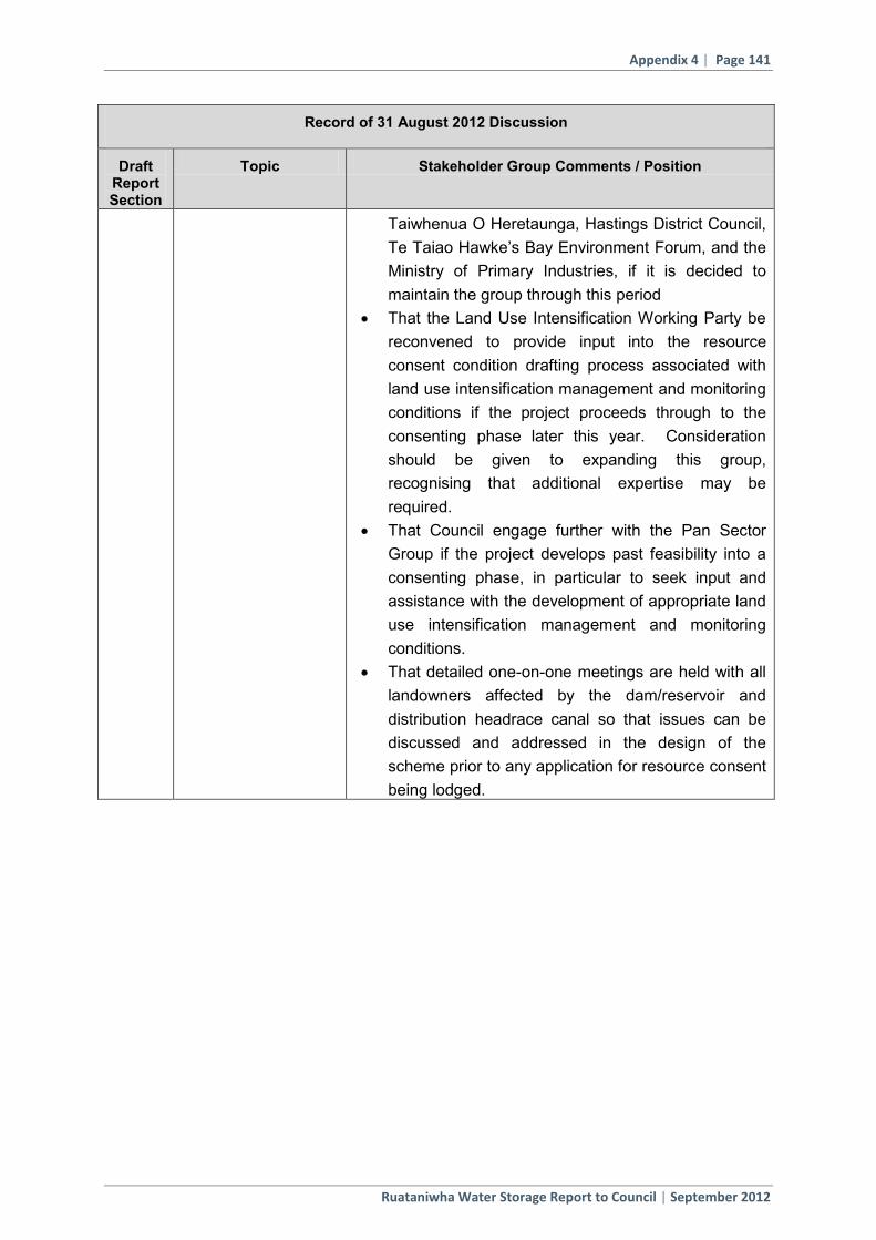
Appendix 4 | Page 141
Ruataniwha Water Storage Report to Council | September 2012
Record of 31 August 2012 Discussion
Draft Report Section
Topic Stakeholder Group Comments / Position
Taiwhenua O Heretaunga, Hastings District Council, Te Taiao Hawke’s Bay Environment Forum, and the Ministry of Primary Industries, if it is decided to maintain the group through this period
That the Land Use Intensification Working Party be reconvened to provide input into the resource consent condition drafting process associated with land use intensification management and monitoring conditions if the project proceeds through to the consenting phase later this year. Consideration should be given to expanding this group, recognising that additional expertise may be required.
That Council engage further with the Pan Sector Group if the project develops past feasibility into a consenting phase, in particular to seek input and assistance with the development of appropriate land use intensification management and monitoring conditions.
That detailed one-on-one meetings are held with all landowners affected by the dam/reservoir and distribution headrace canal so that issues can be discussed and addressed in the design of the scheme prior to any application for resource consent being lodged.

Page 54
Appendix 3 The Approved Minutes of the 31 August 2013 Ruataniwha Stakeholder Group.

File Ref: WTR2/1-9
MINUTES OF A MEETING OF THE RUATANIWHA PLAINS WATER STORAGE STAKEHOLDER GROUP
Date: Friday 31 August 2012 Time: 9.00 am Venue: Council Chamber
Central Hawke’s Bay District Council Present: Debbie Hewitt (Chairman)
Dave Carlton - DOC Grenville Christie – F&B Vaughan Cooper – F&B Pete McIntosh – Fish & Game Phil King – Water User Group Andrew Watts – Land Owner Campbell Chard – Water User Group Christine Scott – HBRC Councillor Benita Wakefield – Te Taiwhenua O Tamatea Hugh Ritchie – Land Owner Tom Belford – Land Owner Peter Butler – CHB DC John Freeman – CHB DC Craig Preston – Land Owner John Cheyne – Te Taiao Environment Group George Williams – Recreational User Group (from 9.45 am)
In Attendance from HBRC:
Andrew Newman Fenton Wilson Graeme Hansen Stephen Daysh, EMS Ltd Grant Pechey Helen Codlin Larissa Coubrough Drew Broadley Barry Lynch Monique Benson Sally Chandler Olivier Ausseil, Aquanet
Observers Marge Hape & Hirani Maaka, Tamatea Taiwhenua Corina Jordan Fish & Game
2
c:\users\administrator\google drive\project archive\sgd292 - rwss\evidence\s daysh\confirmed meeting mins 310812.doc
1. WELCOME AND APOLOGIES The Chairman, Debbie Hewitt welcomed everyone to the meeting.
Apologies were accepted from: Mike Mohi, Liz Graham, Chris Lester and Duncan Holden.
Andrew Watts/Benita Wakefield CARRIED
2. CONFIRMATION OF MINUTES OF MEETING HELD ON 27 JULY 2012 The Minutes of the meeting held on 27 July 2012 a copy having been circulated prior to the meeting were accepted.
Vaughan Cooper/Hugh Ritchie CARRIED
3. REVIEW OF MATTERS ARISING/ACTION ITEMS
There were no outstanding matters arising or action items.
Mr Newman however reiterated his comments from the last minutes ... a plan change alone cannot cancel all current water take consents, but under the minimum flow scenarios being considered there will be less security for current irrigators, which in itself may be an incentive for irrigators to migrate to the storage scheme’ s water.
He further noted that he has been c onsistently suggesting that a c ombination of regulation and storage infrastructure may offer the best route to healthier summer river flows.
Further discussion on plan change and c onsents took place and the following points were noted:
• Stored water provides greater security, potentially providing for 35 year consents
• Transition period an option
• CHB waste water discharge consent must meet standard
• GW/SW migration of consents would be a negotiated process
• Incentives for early uptake
4. PROJECT UPDATE
• Science Caucus – Mr Hansen advised that Iain Maxwell, HBRC Resource Management Group Manager was coordinating this process. Stakeholder group representatives including Benita Wakefield, Pete McIntosh, Tom Belford, Hugh Ritchie, CHBDC and Chris Lester replied to the offer of a caucusing option.
• First meeting sometime mid September.
• Will look at Water Quality, Ecology issues.
• Identify any work still to be done.
• Provide a position statement whether Agree or Disagree with the findings. It is still a useful exercise to undertake.
• Aquatic Ecology - Mr Daysh advised the comments provided by John Cheyne and his group to the Cawthron report had been responded to and included in the final Cawthron report.

3
c:\users\administrator\google drive\project archive\sgd292 - rwss\evidence\s daysh\confirmed meeting mins 310812.doc
• Off-set Mitigation – Mr Daysh advised a r esponse had been pr ovided to Mr Cheyne following his comments on the Offset Mitigation report.
• Following a q uestion on when the 100 poi nt survey was taking place in the catchment Mr Ausseil advised staff were just waiting on r iver conditions and weather to improve.
•
5. LUI UPDATE Mr Daysh advised a final copy of the LUI Working Party report was available for members to sign or the option not to sign if you weren’t at the last meeting.
Hugh Ritchie recommended the group reconvene at some stage to work on appropriate land management plans for farmers.
8. DRAFT FEASIBILITY SUMMARY REPORT TO COUNCIL Stephen Daysh provided the group with an overview of the report that was emailed earlier in the week giving clarification on what outcome was expected for the group.
A draft document, with suggested stakeholder comments, was circulated at the meeting that gave an outline of the items that needed to be discussed, debated and agreed upon if possible.
The document was shown on the screen allowing for comments and amendments to be directly inserted. This was carried out by Larissa Coubrough.
An updated version is attached to these minutes.
Mr Daysh proceeded to read through the items:
Items 1.1 & 1.2 - Agreed – All
Items 1.3.1 & 1.3.2 – following a poi nt of order, Fish & Game advised they would abstain from participating in the remainder of this agenda item until they had time to fully comprehend it. They advised they would provide their position in writing.
Craig Preston questioned whether Fish & Game had surveyed their CHB members for their feedback on the project and they responded that they hadn’t spoken directly to their members.
Item 1.3.3 – Agreed – All
Item 1.4.1 – Agreed – All
Item 1.4.2 – Agreed - All
Item 1.4.3 – The following did not agree with the statement – Tom Belford, Grenville Christie, John Cheyne, Vaughan Cooper; they considered that additional modelling work should be undertaken prior to deciding on project feasibility.
Clarification was provided on the project timeline –
• 26 September Council meeting - full Feasibility Report presented to Council
• 31 October Council meeting – Council decision due on project feasibility
Meeting broke for morning tea at 10.40 am and resumed at 11.00 am
Item 1.5.1 – Agreed - All.
Item 1.5.2 – Tom Belford and Grenville Christie reserved their support. Dave Carlton from DOC did not support the trap & transfer programme recommended.
4
c:\users\administrator\google drive\project archive\sgd292 - rwss\evidence\s daysh\confirmed meeting mins 310812.doc
It was advised that mitigation costs had been modelled into the financial feasibility for the project.
A correction to last paragraph of the Aquatic Ecology recommendation was noted.
Item 1.6 – Agreed – All.
Benita Wakefield indicated that whilst she shared some of Fish & Game & Tom Belford’s concerns about potential effects on the river. While advising the importance of improving and enhancing the Mauri of the river there were also wider considerations including economic and s ocial and on balance, supported the development going forward.
Items 1.7.1, 2, 3, 4, 5, 6 – Agreed All
Item 1.8 – Agreed All. It was noted DOC believed there were more opportunities that could be r ealised within the current budget provision for the offset mitigation work recommended.
It was requested by Vaughan Cooper (Forest & Bird) that Mitigation work should be mandated in the resource consent application and not left as “best effort”. This also applied to 1.5.1 and 1.5.2.
Item 1.9 – Agreed All. Item 1.10 – Tom Belford reserved his position.
Item 2.1 to 2.7 – Agreed All.
Item 2.8 – Note: a) recommendation - invite HDC and Te Taiao Environment Forum to join the stakeholder group. Note: b) Consideration be given to expanding the LUI working group with suitably qualified members i.e. farming technical / industry expertise.
Note: to amend Clause C to D and add c lause C from environmental report.
Recommendation That the Stakeholder Group agree the position paper Record of 31 August 2012 Discussion be included as their recommendation and i ncluded in the Environmental, Social and C ultural Studies and Community Engagement section of the Feasibility Report to Council dated September 2012.
Benita Wakefield/Andrew Watts CARRIED
UNAMIOUSLY
Dr Barry Lynch – was introduced to the group. D r Lynch provided an update from Council on the position of Cadmium in the soil. The following was noted:
• Cadmium accumulation in soils is primarily associated with the application of phosphate based fertilizers as cadmium is a trace contaminant found in phosphate rock, the raw material for phosphate fertilizers
• The best way to reduce the rate of cadmium accumulation in soils is by reducing the cadmium content of the phosphate fertilizers.
• This issue is well acknowledged by the farming industry and government agencies. The Ministry for Primary Industry (MPI) is currently working on a plan in conjunction with fertilizer companies, farmers, regional councils and research establishments to deal with this issue. The MPI have established a Cadmium Management Group (CMG) which has already published a cadmium management strategy (2011) and will
5
c:\users\administrator\google drive\project archive\sgd292 - rwss\evidence\s daysh\confirmed meeting mins 310812.doc
ensure that risk based guidelines for management of cadmium are in place by 2017.
• Council already has more than 30 soil quality monitoring sites that are sampled every year for multiple parameters including cadmium. This current network of sites is being added to annually until a regional coverage is attained (approximately 92 sites).
7. UPDATE ON ECONOMICS
Mr Newman introduced Mr Grant Pechey. An overview of the project economics was provided.
Mr Pechey showed a selection of slides from Macfarlane Rural Business - Review of Farm Profitability.
The meeting broke for lunch at 12.45 pm and returned at 1.30 pm
The following participants did not return to the meeting from the lunch break –
Andrew Newman, Fenton Wilson, Campbell Chard, Benita Wakefield, Marge Hape & Hirani Maaka.
6. TUKITUKI CHOICES SCENARIOS – HELEN CODLIN Helen Codlin provided an update on the Tukituki Choices document and process. ACTION: Provide the Stakeholder Group with a list of all the public meetings scheduled. The group discussed different aspects of the presentation and the following was noted:
• In response to a question from Mr Belford on why the stakeholder group was not
asked to provide input into this document, after being told at an earlier meeting that it would, Mrs Codlin advised she was not aware of this.
• Stephen Daysh also commented that he di d not recall this commitment being
made at the last meeting and he did not think it had been recorded as an Action in the 27 July Stakeholder Meeting minutes.
• Mrs Scott advised a wide number of groups had informed the development of the document -including those participating in the Water and Land Strategy Group.
• Mr Belford believed the LUI working group had access to the most critical issues
and they could have provided valuable input to the scenarios. He suggested HBRC staff had identified the preferred option and put that into Tukituki Choices.
• Stephen Daysh disagreed with the position Mr Belford put. He believed the LUI
working party did have input into the scenarios. The LUI Working Party Minutes of 9 A ugust (Special Meeting regarding Policy Issues) and 17 August (Final Working Party Meeting) which are appended t o the Final LUI Working Party Report record the discussions between Helen Codlin and the members of the Working Party regarding the future scenarios and the position of the parties.
• Helen Codlin also responded confirming that no decision had been made and that
the Choices were scenarios only, and the document was a consultation document only.
6
c:\users\administrator\google drive\project archive\sgd292 - rwss\evidence\s daysh\confirmed meeting mins 310812.doc
• Mr Belford advised that at last LUI working party meeting there was disagreement
around “these numbers” and asked that “you note the reservations we have”. He believed this was not answered or reflected in the framework presented.
• Helen Codlin confirmed that drafts of the Scenario Construction Report had been
circulated to and di scussed with the LUI Working Party and t hat Choice B had been adapted after the 9 August LUI Working Party Meeting to reflect the suggestion from Fish & Game at the 9 August meeting that N limits be based on managing periphyton growth (and not nitrate toxicity).
• Mr Ritchie asked how farmers would know if their bore is a stream depleter or not
and indicated they would need to know that in order to evaluate the scenarios. He also noted that the document should be clear that Land/farm Management Plans will be a requirement of any Storage Scheme.
• Mr Cheyne questioned the zones and trout spawning locations indicated within the
scenarios, he said that most of the spawning occurs between SH50 and SH2 in the main rivers and tributaries. It was advised the location of the zones related to Water Management Zones within the catchment, and di d not necessarily reflect the location of spawning habitats.
• Mr Cheyne suggested that by increasing the nitrate toxicity guideline, HBRC staff
had created more headroom so that it made the storage project feasible in his view this equated to a permit to pollute, which was unacceptable.
• Helen Codlin responded that the scenarios were based on t he Nitrate Risk
Framework developed by Dr Chris Hickey for the Tukituki catchment and based on the ANZECC methodology, and it represents the latest scientific findings. She acknowledged that the report was only recently completed and that the Group had not had an opportunity to review this report and that copies were now available.
• Olivier Ausseil commented that Dr Hickey is a leading scientist in this field, and is
an independent professional who was asked to undertake independent work, and this was the basis under which all external experts for the project were engaged. Dr Ausseil stated that the numbers came out higher than the 2009 ECan review, but could equally have come out lower. The final numbers were a reflexion of the data, not of HBRC staff trying to influence the outcomes of Dr Hickey’s work. Suggesting otherwise was calling Dr Hickey’s integrity into question.
• Helen Codlin suggested a s entence could be i ncluded in the Tukituki Choices
document if the group agreed along the lines of “environmental groups challenge some of the data”. Draft wording was suggested on white board, but when asked, no one in the group indicated they wanted it included.
• It was suggested that this group make a submission to the Tukituki document and
that a s pecial meeting of the Group be or ganised to provide feedback on the Tukituki Choices discussion document.
Other Items
• Mr Broadley advised that the Ruataniwha Water Storage Project was now framed by the Tukituki Choices Project.
• Mr Belford advised of a public forum taking place at EIT on 18 September, speakers
confirmed at this stage were Andrew Newman and Dr Roger Maaka.

7
c:\users\administrator\google drive\project archive\sgd292 - rwss\evidence\s daysh\confirmed meeting mins 310812.doc
• New works for the project including optimisation to be identified, budget and MPI support being worked through.
• Full Feasibility document will be presented to Council on 26 S eptember. T ukituki
Choices consultation running alongside this. • This group to review Tukituki Choices document and discuss and provide feedback to
Council. ACTION – date to be confirmed. • Concern was raised on the ‘self audited management’ approach proposed for
farmers and that this approach would be too soft with few results achieved. It was clarified that this approach is easily confused but is in fact an audited self management approach which would require on farm audits from an external body. The details of this are yet to be de fined but would require some sort of on farm planning (including nutrient) and assurance that the plan is being implemented.
• In summing up Mrs Hewitt noted that the LUI Working Party report had been s igned
by all except Fish & Game.
• She also recommended the group review the Social Impact Assessment report that had been provided and pass on the recommendations to the community.
The meeting closed at 2.45 pm.

Page 55
10. EXHIBITS
Exhibit SGD 1: Mana Whenua Working Party report

Mana Whenua Working Party Report Ruataniwha Water Storage Scheme
Prepared by the RWSS Mana Whenua Working Party August, 2013
TABLE OF CONTENTS
1.0 Introduction ............................................................................................................... 1
2.0 Project Information – RWSS ...................................................................................... 2
3.0 Cultural Values ........................................................................................................... 3
3.2 Origins, Settlement, History .............................................................................................. 5 3.2 Pūrākau ............................................................................................................................. 5 3.3 Key cultural values ............................................................................................................ 5
4.0 Legal Framework ....................................................................................................... 6
4.2 Resource Management Act 1991 ..................................................................................... 6 4.3 Treaty of Waitangi Claims ................................................................................................. 7
5.0 RWSS Mana Whenua Working Party ......................................................................... 8
5.1 Terms of Reference ........................................................................................................... 8 5.4 Working Party Process ...................................................................................................... 8
6.0 Key issues and agreed approach on effects ............................................................ 10
APPENDIX: A Terms of Reference – RWSS Mana Whenua Working Party
Mana Whenua Working Party Report Final - August 2013
P a g e | 1
1.0 INTRODUCTION
In 2009, the Hawke’s Bay Regional Council (“HBRC”) embarked on investigating the potential for water storage in the Tukituki River catchment in Central Hawke’s Bay for a number of regionally significant purposes including suitable river flow for supported values, water quality protection or enhancement and community economic opportunity. Eighteen potential sites for water storage were initially considered however, after much investigation, the upper Mākaroro River was identified as the preferred site in 2011 and full feasibility investigations for the Ruataniwha Water Storage Scheme (“RWSS”) were launched and concluded in August 2012.
Three cultural impact assessments (CIA) (Wakefield et al., 2010; 2011: Apatu et al., 2012) were commissioned by HBRC. The first of these reports investigated eight potential water storage dam sites with the second narrowing the focus to two potential storage dam sites on the Mākāretu and Mākaroro Rivers. The third report focused on the cultural values and uses associated with the lower Tukituki catchment and impact assessment of a storage dam on the Mākaroro River.
These cultural impact assessments contributed to the Feasibility Study which recommended the final site on the Mākaroro River.
A fourth joint report utilising input from the three reports outlined above was prepared by Te Taiwhenua o Tamatea in partnership with Te Taiwhenua o Heretaunga (Wakefield et al., 2012).
From this report the HBRC Ruataniwha Water Storage Scheme Core Project Team made the following observations (HBRC, 2012).
In relation to the recommendations contained in the Cultural Impact Assessment Report we consider the following matters are relevant considerations:
(a) The recommendations regarding governance and management associated with the Tukituki Catchment seem to be largely addressed by the co-governance function of the recently established HBRC Regional Planning Committee whose function is to oversee the development of policy and plan instruments for the catchment.
(b) The recommendations associated with “mauri” have been recognised and addressed through the development of the integrated mitigation and offset report, with iwi representation proposed on the administering Trust.
(c) Council is assessing the implementation of higher minimum flow limits to address the historic low flow issues in the catchment, as part of the upcoming Plan Change.
We consider that further discussions should be held with Te Taiwhenua O Tamatea and Te Taiwhenua O Heretaunga in relation to the other key recommendations such as:
(a) How to realise potential social and economic benefits for tangata whenua.
(b) Potential involvement of tangata whenua in monitoring.

Mana Whenua Working Party Report Final - August 2013
P a g e | 2
(c) How best to define and recognise any unregistered wāhi tapu / wāhi taonga; and
(d) Historic Places Act authority requirements including the development of appropriate Accidental Discovery Protocols.
At a meeting on 19 November 2012, involving representatives of HBRIC, Te Taiwhenua o Tamatea and Te Taiwhenua o Heretaunga, it was agreed to establish a Working Party to advise on how best to implement the Wakefield (2012) recommendations associated with the RWSS. A further meeting was held on 22 November 2012 to discuss the form of the Working Party and nominations for the Working Party were subsequently received.
The purpose of this report is to document the RWSS Mana Whenua Working Party process which has considered the RWSS and recommended ways in which the concerns held by mana whenua regarding the cultural impacts of the RWSS can be addressed.
As background information this report also includes excerpts of the history of the land (whenua), waters (wai) and cultural values associated with these taonga.
2.0 PROJECT INFORMATION – RWSS
Hawke’s Bay Regional Investment Company Limited (HBRIC) seeks resource consents and confirmation of a notice of requirement to enable it to build and operate a 90 million cubic metre storage reservoir and associated intakes, canals, pipelines and outfalls together providing a water distribution network. The dam will be located in the upper Mākaroro River in Central Hawke’s Bay where it will harvest winter and other high flows and provide the storage reservoir to supply water for irrigation to between 25,000 and 30,000 hectares, providing a reliable irrigation supply for at least 19 in every 20 years.
The reservoir will also provide an important resource to maintain higher flows from the Mākaroro River contributing to the Tukituki River system at times when flows are most under stress and assist the management of excess periphyton that currently diminishes recreational amenity in the lower river. The project includes a small (6.5MW) renewable energy hydro-electric power station to be constructed adjacent to the dam.
Comprehensive land use consent applications cover the activities associated with the Scheme within the administrative jurisdiction of each of the Central Hawke’s Bay District Council (hereafter referred to as CHBDC) and Hastings District Council (hereafter referred to as HDC).
Applications for a total of fifteen resource consents cover those aspects of the Scheme within the administrative jurisdiction of the HBRC. The applications are structured in a manner whereby there is a single comprehensive resource consent application for the construction, operation and maintenance of each key element of the RWS Scheme (or group of similar activities) along with separate resource consent applications for the damming, diversion, take, use and discharge of water associated with each of the various elements of the RWS Scheme as required (post construction).
In addition, there will be two regional land use consent applications, one for the use of production land, and the other for plantings within a Flood Control Scheme area. Finally, there is an application for a coastal permit to authorise deposition of sediment within the Coastal Marine area to the north and south of the mouth of the Tukituki River for the purposes of beach nourishment.
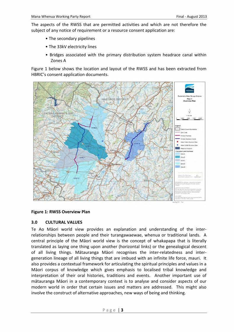
Mana Whenua Working Party Report Final - August 2013
P a g e | 3
The aspects of the RWSS that are permitted activities and which are not therefore the subject of any notice of requirement or a resource consent application are:
• The secondary pipelines
• The 33kV electricity lines
• Bridges associated with the primary distribution system headrace canal within Zones A
Figure 1 below shows the location and layout of the RWSS and has been extracted from HBRIC’s consent application documents.
Figure 1: RWSS Overview Plan
3.0 CULTURAL VALUES Te Ao Māori world view provides an explanation and understanding of the inter-relationships between people and their turangawaewae, whenua or traditional lands. A central principle of the Māori world view is the concept of whakapapa that is literally translated as laying one thing upon another (horizontal links) or the genealogical descent of all living things. Mātauranga Māori recognises the inter-relatedness and inter-generation lineage of all living things that are imbued with an infinite life force, mauri. It also provides a contextual framework for articulating the spiritual principles and values in a Māori corpus of knowledge which gives emphasis to localised tribal knowledge and interpretation of their oral histories, traditions and events. Another important use of mātauranga Māori in a contemporary context is to analyse and consider aspects of our modern world in order that certain issues and matters are addressed. This might also involve the construct of alternative approaches, new ways of being and thinking.

Mana Whenua Working Party Report Final - August 2013
P a g e | 4
Wise management of taonga requires an understanding of the spiritual realm (Ira Atua) and the physical realm (Ira Tangata) so that a place and its mātauranga are inseparable, interrelated and interdependent. Whakapapa-ranga enables this to occur inter-generationally through the passing down of knowledge of these connections and associations.
The concept of whanaungatanga to mana whenua refers to the rights, obligations and dynamic relationship between marae and hapū. There is an emphasis on kinship bonds and reciprocal responsibilities in determining action and the importance of whakapapa in establishing rights and status of mana. The origins, settlement and history of Māori to the areas surrounding the Tukituki River catchment reinforce the notion of hapū and marae allegiance: for demonstrating the kinship bonds which hold marae and hapū together as a distinct people.
Kaitiakitanga refers to the act of guardianship and while kaitiaki are the traditional guardians with reciprocal responsibilities to protect the natural elements, people have taken on the kaitiaki responsibilities as stewards to protect the spiritual wellbeing of whanau, marae and hapū through the wise management of taonga or natural resources and to ensure the mana of mana whenua is upheld.
In summary, the following table was prepared by Wakefield (2012) to provide an overview of how mana whenua have expressed their relationship to their traditional lands, taonga tuku iho and kaitiakitanga responsibilities to uphold the integrity of the mauri of the waterways and to the protection of their waahi tapu and landscapes of particular significance.
Table 1: “Tukituki River Catchment Cultural Values & Uses” (Wakefield et al., 2012).
Mana Whenua Working Party Report Final - August 2013
P a g e | 5
3.2 Origins, Settlement, History
Many ancestral lines have led to the marae/hapu descendants in the Ruataniwha plains and Ruahine range areas to the present day. The Ruahine Ranges were not extensively settled by Māori and were instead passageways for seasonal expeditions by the tribes of Ngāti Kahungunu, Ngāi Tahu, Ngāti Apa and Rangitane to and from the coastal lowlands to inland Mokai Patea and the central plateau. The ranges also provided refuge to settled tribes from raiding parties.
Rangitane was one of the earlier tribes to settle in the Ruataniwha plains but was eventually settled in the area south of the present day town of Dannevirke to the Manawatu and the Wairarapa and Ngati Kahungunu became the dominant tribal group of this area with different hapu settling on the Ruataniwha plains.
The history of settlement from the Ruahine ranges down to the Ruataniwha plains and beyond to the Heretaunga Plains were shaped and influenced by the many battles and skirmishes that occurred throughout the history of settlement. Some of the most important events to shape the history of all the marae and hapū take place in the Ruahine Ruataniwha area around the period leading into the 1800’s and after. It is the period referred to as, ‘Ko a tatou ririri tara a whare’ – their own interal hapu fights between two kin groups of these lands, Te Upokoiri and her brother Manawakawa.
3.2 Pūrākau
According to Māori narratives and oral history, the plains were once covered by a large lake which was the lair of two enormous taniwha who regarded the Māori living around the lake as a source of food. One narrative associated with the lake and Waipawa and Tukituki Rivers describes a fierce battle between the two taniwha for a plump little boy who had unfortunately fallen into the lake near where the Waipawa and Tukituki Rivers now flow. The wild lashing of their tails cut through the eastern hills and the lake poured out forming the two rivers.
3.3 Key cultural values
Kaitiakitanga - from the Hapu perspective Kaitiakitanga is not a passive custodianship, nor is it simply the exercise of traditional property rights, but entails an active exercise of mana to look after the taonga to hand on to future generations.
Rangatiratanga - refers to having Mana and relationships between our culture and traditions, with the natural world. Rangatiratanga is traditionally embodied within the concept of Manawhenua.
Manawhenua incorporates customary rights and obligations attached to our lands.
Mahinga kai are places and resources important for the sustenance of our Whanau.
Manaakitanga for our Whanau is the practice of our hospitality towards manuhiri.
Mauri is the life force of paramount importance to the wellbeing in both our physical and spiritual worlds which includes our taonga such as ngawha, puia, waiariki, Wāhi Tapu and whenua.
Taonga are our taonga tuku iho derived from Atua through whakapapa to us which includes (amongst others) all natural resources, air, land, water both tangible and intangible.

Mana Whenua Working Party Report Final - August 2013
P a g e | 6
Tikanga are customs and practices determined, maintained and regulated by our Whanau such as (amongst others) pepeha, whakatauki, moteatea, patere, tauparapara, whakapapa.
Wāhi Tapu are our sacred areas held in reverence according to our tikanga and history
Rongoa is our traditional medicine regulated and maintained in accordance with our tikanga.
Mana tangata is the identification and recognition of Whanau and ownership through whakapapa.
Puurakau are the traditional stories about our histories and tipuna handed down.
4.0 LEGAL FRAMEWORK
4.2 Resource Management Act 1991
The Resource Management Act 1991 (RMA) promotes sustainable management of natural and physical resources and seeks to minimise or offset any adverse environment effects associated with development.
The RMA establishes a regulatory regime whereby certain activities are authorised by rules in the district and regional plans.
To better understand the effects associated with the RWSS, it is recognised that the applications need to be considered within the context of RMA principles relating to “sustainable management”, including “the existing environment baseline”, and the guiding Māori principle of kaitiakitanga.
“Sustainable management“ is defined in section 5 of the RMA, and incorporates the concepts of current economic, social and cultural wellbeing, with sustaining the needs of future generations and safeguarding the life supporting capacity of natural resources and avoiding, remedying or mitigating adverse effects of activities on the environment.
Case law determines that the correct approach to apply is an overall “broad judgment” to determine whether the sustainable management purpose of the RMA is being achieved. That means taking account of the intrinsic nature of the resource, enabling use and development for the benefit of the community and New Zealand, and identifying ways of avoiding, remedying or mitigating adverse effects on the environment.
With respect to “the existing environment baseline”, case law has determined that in assessing the actual and potential effects of activities on the environment, this must be on the basis of the environment as it currently exists. It is not appropriate to take a historical state of the environment as a reference point.
Under New Zealand’s existing RMA framework kaitiakitanga is defined as meaning the exercise of guardianship by the tangata whenua of an area in accordance with tikanga Maori in relation to natural and physical resources; and includes the ethic of stewardship.
Mana Whenua Working Party Report Final - August 2013
P a g e | 7
4.2.1 Part II
Part II of the RMA sets out the purpose and principles of the Act, which includes section 5 (Purpose of the Act), section 6 (Matters of National Importance), section 7 (Other Matters) and section 8 (Treaty of Waitangi).
Section 5 of the RMA states:
“The purpose of this Act is to promote the sustainable management of natural and physical resources.”
In achieving the purpose of the Act, sections 6 and 7 of the RMA recognise the important role of Māori in relation to managing the use, development and protection of natural and physical resources. This includes a requirement to recognise and provide for:
6(e) The relationship of Māori and their culture and traditions with their ancestral lands, water, sites, waahi Tapu, and other toanga”;
and have particular regard to:
7 a) Kaitiakitanga; and
7 aa) The ethic of stewardship:
Section 8 of the RMA states:
“In achieving the purpose of this Act, all persons exercising functions and powers under it, in relation to managing the use, development, and protection of natural and physical resources, shall take into account the principles of the Treaty of Waitangi (Te Tiriti o Waitangi).”
4.3 Treaty of Waitangi Claims
A number of Treaty of Waitangi Claims have been lodged with the Waitangi Tribunal in the Tribunal’s Southern Hawkes Bay Inquiry District (SHBID). He Toa Takitini is the organisation, mandated by hapū/marae claimant groups within the Heretaunga-Tamatea Inquiry District to:
• Settle the many claims in the Inquiry District through Direct Negotiations with the Crown,
• keep all claimant groups and the wider iwi informed,
• be a point of contact for all whose interests the different claims represent.
Treaty Claims are matters for the Crown to determine, and are separate from RMA resource consent processes. RMA case law makes this separation between the two processes clear.1
HBRIC acknowledges these claims and respects the process that is being undertaken. It understands that Māori will have to deal directly with the Crown on these matters, as will HBRIC.
HBRIC recognises the benefits of adopting a partnership approach to work towards a longer-term relationship with Mana Whenua.
1 See Ngāti Rangi Trust v The Manawatu-Wanganui Regional Council (Environment Court A067/2004).
Mana Whenua Working Party Report Final - August 2013
P a g e | 8
5.0 RWSS MANA WHENUA WORKING PARTY
5.1 Terms of Reference
Terms of Reference (“TOR”) for the Working Party are attached as Appendix A to this report.
The objectives of the Working Party are as follows:
• To provide a forum for discussing the recommendations associated with the proposed Ruataniwha Water Storage Project (RWS) contained in the “Tukituki River Catchment Cultural Values and Uses” Report, June 2012. Three prior cultural evaluation and assessment reports2 gave background to this June 2012 report.
• To facilitate any necessary presentations to the Working Party from experts associated with effects of specific interest to Mana Whenua.
• To prepare an agreement between the parties, including;
(a) an agreed position on how to appropriately implement the “Tukituki River Catchment Cultural Values and Uses” Report recommendations (including, but not limited, to resource consent conditions); and
(b) Defining employment and economic opportunities which may be able to be accommodated through the RWS project.
5.4 Working Party Process
In order to come to an understanding of the proposed RWSS and identify issues of concern for mana whenua, the Working Party held numerous meetings, hui-a-iwi, hui-a-hapu workshops and a site visit. The full work programme of the Working Party is outlined in Table 2.
Table 2: Working Party Work Programme
DATES HUI AND MILESTONES
30 November 2012 Nominations of members for the Working Party confirmed and amendments to draft ToR received.
17 December 2012 Working Party first hui. Amendments to draft ToR discussed and resolved, copy to be re-distributed and further amendments/clarifications sought. Final released thereafter.
2“Cultural Impact Assessment of the Tukituki Proposed Water Storage Dams”, 10 September 2010.
“Cultural Impact Assessment of the Tukituki Proposed Water Storage Dams: Supplementary Report on the Makāretu and Mākāroro Proposed Dam Sites”, March 2011.
“Cultural Values and Uses, Cultural Impact Assessment Report of the Lower Tukituki Catchment”, 16 May 2012.
“Ko wai ko hua - Tukituki River Catchment Cultural Values and Uses”, June 2012.
Mana Whenua Working Party Report Final - August 2013
P a g e | 9
DATES HUI AND MILESTONES
15 January 2013 Working Party and technical experts to RWSS team hikoi to Mākaroro River and downstream environments (Waipawa and Tukituki Rivers).
24 January 2013 Working Party planning session to discuss and confirm the key focus areas for the group.
8 February 2013 Working Party Environment Focus Day (Ecology effects, Offset proposal, Trap and Transfer).
22 February 2013 Working Party Employment Focus Day (Employment Opportunities).
7 MARCH 2013 HUI-A-IWI “FISH HOOK SUMMIT”.
15 March 2013 EPA pre-lodgement review / completeness check.
21 March 2013 Working Party hui to confirm matters to be addressed in MOU / Agreement. Ruataniwha Tauwhiro Taitaiao (RTT) Concept discussed
27 MARCH 2013 HUI-A-HAPŪ HOSTED BY TAMATEA TAIWHENUA
4 April 2013 Working Party hui – Technical presentation and discussion on groundwater nitrates. Extension of Working Party timeframe discussed
17 April 2013 Working Party hui – Offset Mitigation discussion with environmental groups and presentation of Draft Zone M CIA Addendum
6 May 2013 Final resource consent application documentation lodged with EPA.
May / June 2013 Various Nga Marae hui
24 May 2013 Working Party hui to discuss planning for the next steps for the Working Party post lodgement of the RWSS applications
12 June 2013 Working Party hui to review and confirm key issues to be included in the final Working Party Report
20 June 2013 Working Party hui to discuss and confirm the updated draft Working Party Report to a Final Draft Stage
5 July 2013 Working Party hui to discuss and confirm the Final
Mana Whenua Working Party Report Final - August 2013
P a g e | 10
DATES HUI AND MILESTONES
Draft Working Party Report to a Final Stage for Signing
6.0 KEY ISSUES AND AGREED APPROACH ON EFFECTS
As set out in the Terms of Reference, one of the objectives of the Working Party is to prepare an agreed position on how to implement the Wakefield (2012) report recommendations (including, but not limited to, resource consent conditions) and defining employment and economic opportunities which may be able to be accommodated through the project.
To assist with this, the Working Party members have identified key issues, and through discussion have developed an agreed approach, as presented in Table 3.
Table 3: Key Issues and Agreed Approaches
Key Issue Working Party Comments Agreed Approach
Social and Economic Opportunities
This was a key focus area for the Working Party as confirmed in the planning hui held on 24 January 2013, and these matters were discussed in detail during the Employment Focus Day held on 22 February 2013.
The Working Party supports the recommendations contained in the Taylor Baines Social Impact Assessment lodged with the RWSS resource consent applications, which it is noted HBRIC Ltd are seeking to implement in partnership with a range of Hawke’s Bay agencies under a MOU regarding the management and monitoring of the Socio-Economic Effects of the RWSS.
1. On the recommendation of the Working Party, HBRIC Ltd has set a requirement in the RWSS Design and Construction Tender process that a “Hawke’s Bay Industry Participation Policy Statement” to identify work and training opportunities for local people, including mana whenua be included in the tenders from the two consortia bidding for the contract.
2. A copy of a Mana Whenua Values and Aspirations document prepared by the Working Party has been supplied to the two consortia to provide more focus for them in the preparation of their respective Hawke’s Bay Industry Participation Policy Statements.

Mana Whenua Working Party Report Final - August 2013
P a g e | 11
Key Issue Working Party Comments Agreed Approach
3. HBRIC Limited have agreed that the Working Party will be involved in evaluating the Design and Construct tender proposals in relation to the Hawke’s Bay Industry Participation Policy Statements as lodged by the two consortia.
4. Te Taiwhenua o Tamatea, Te Taiwhenua o Heretaunga, Nga Marae o Heretaunga and Ngati Kahungunu Iwi Incorporated have been asked to be parties to a Socio-Economic MOU which will establish a Ruataniwha Socio-Economic Working Party to oversee the implementation of the socio-economic report recommendations contained in the Taylor Baines report (May 2013) lodged with the RWSS resource consent applications.
Environmental Effects Including Mitigation and Monitoring
This was a key focus area for the Working Party as confirmed in the planning hui held on 24 January 2013, and these matters were discussed in detail during the Environment Focus Day held on 8 February 2013 and during the Environmental Offset hui held with the environmental groups on 17 April 2013.
The Working Party have worked with Dr Roger Young from Cawthron Institute to consider and assess the various options for mitigating the effects on native fish including long fin eels and
1. The Agreement between HBRIC Ltd and Te Taiwhenua o Tamatea recognises the particular cultural and resource management values held by Tamatea (including as to waahi tapu, mahinga kai, taonga and mauri) and the need to recognise, provide for and maintain the relationship between Tamatea and their ancestral lands, water, sites, waahi tapu and other taonga affected by the construction
Mana Whenua Working Party Report Final - August 2013
P a g e | 12
Key Issue Working Party Comments Agreed Approach
support the proposals for the Upstream and Downstream Trap and Transfer proposal for long fin eels and the offset approach for enhancing habitat for native fish in other areas of the Tukituki catchment contained in the HBRIC document filed with the applications for the Resource Consents entitled Ruataniwha Water Storage Scheme: Proposed Integrated Mitigation and Offset Approach (HBRIC May 2013 f)
The Working Party supports the resource consent conditions dated May 2013 proposed by HBRIC Ltd regarding:
• Paragraphs 18 – 24 of Schedule One to the Proposed Conditions Document relating to the Reservoir Filling and Edge Rehabilitation Plan (RFERP);
• Paragraphs 40-43 of Schedule One of the Proposed Conditions Document relating to Construction Liaison Group;
• Paragraph 1 -3 of Schedule Two to the Proposed Conditions Document relating to the Integrated Mitigation and Offset Programme, and with express reference to the HBRIC document filed with the applications for the Resource Consents entitled Ruataniwha Water Storage Scheme: Proposed Integrated Mitigation and Offset Approach (HBRIC May 2013 f); and
and subsequent use and operation of the RWSS, including their role as kaitiaki. This agreement includes:
a. A first right for Ruataniwha Tauwhiro Taitaiao to secure the contracts to undertake the five projects identified in the Ruataniwha Water Storage Scheme: Proposed Integrated Mitigation and Offset Approach (HBRIC May 2013 f). and
b. An education and training fund with a priority to support those who whakapapa to, or can evidence strong affiliation with the Ruataniwha District.

Mana Whenua Working Party Report Final - August 2013
P a g e | 13
Key Issue Working Party Comments Agreed Approach
• Paragraphs 28 and 29 of Schedule Three to the Proposed Conditions Document relating to the Scheme Operations Liaison Group.
The Working Party would like the conditions to be clear that any changes to representation groups post settlement governance entity can be accommodated.
Cultural and Accidental Discovery Protocols
This was a key focus area for the Working Party as confirmed in the planning hui held on 24 January 2013.
A Cultural and Accidental Discovery Protocol has been prepared with the assistance of Professor Roger Maaka.
1. Support by the Working Party for the Cultural and Accidental Discovery Protocol submitted as part of the RWSS Proposed Resource Consent Conditions (Schedule Seven).
2. HBRIC Ltd agree to facilitate a cultural blessing of the Makaroro Dam Site area prior to construction commencing.
3. HBRIC Ltd agree to engage with representatives of Mihiroa and Kahuranaki marae to ascertain if they have any concerns associated with Zone M over and above those identified in the Zone M CIA Addendum Report.
Deforestation of the Tukituki Catchment
Working Party members are concerned with the adverse environmental effects associated with the historical deforestation of the Tukituki Catchment area and would like to see a strategic approach undertaken by HBRC to
1. Through implementing the integrated mitigation and offset programme opportunities for re-forestation and native vegetation should be a
Mana Whenua Working Party Report Final - August 2013
P a g e | 14
Key Issue Working Party Comments Agreed Approach
addressing this issue over time.
The Working Party accepts that this is a catchment wide issue which needs to be addressed in a concerted and sustained way by HBRC and that apart from providing for appropriate offsets for the direct effects of the RWSS on the terrestrial vegetation that will be inundated by the Makaroro Dam Reservoir, other programmes are required to address this issue. These include:
• The Tukituki Catchment Implementation Plan which is part of Proposed Plan Change 6 and which identifies non-regulatory actions including the identification of priority sub-catchments which require remediation through a multi-party approach
• The development and implementation of the HBRC Biodiversity Strategy which is currently a focus for HBRC.
The Working Party wishes to ensure that mana whenua are involved at all levels of the planning and implementation processes identified above to ensure their views and concerns are recognised and provided for in terms of long term Tukituki catchment care.
priority.
2. That this issue of concern for the Working Party be brought to the attention of HBRC via the Regional Planning Committee with a request that mana whenua be involved at all levels of the planning and implementation processes associated with:
• The Tukituki Catchment Implementation Plan; and
• The HBRC Biodiversity Strategy.
Investment and Representation
The Working Party would like to record that they consider that it is important that mana whenua continue to have representation on HBRIC Ltd Board and any subsequent commercial entity, (even if there is no direct
1. That this recommendation be presented to the HBRIC Board for consideration.

Mana Whenua Working Party Report Final - August 2013
P a g e | 15
Key Issue Working Party Comments Agreed Approach
investment), in order to ensure the continuity of mana whenua representation at the “top table”.
Use of Mana Whenua Working Party Model for future processes
There may be other specific projects within the region that would benefit from the convening of a similar group in the future.
The Working Party members consider that the working process and outcomes achieved through the Mana Whenua Working Party forum has been a positive and successful model for ensuring robust and effective engagement of relevant mana whenua with local government regarding a specific resource management issue.
1. That this conclusion be reported to HBRC via the Regional Planning Committee with a presentation of this report to the Regional Planning Committee by Working Party members.
Mana Whenua Working Party Report Final - August 2013
P a g e | 16
The Ruataniwha Mana Whenua Working Party records participation in the Working Party and acknowledges the Agreed Approach in Table 3 above, which was discussed and agreed following the process of hui outlined in Table 2 of this document.3
Ruataniwha Mana Whenua Working Party
Signed by Professor Roger Maaka Rongo o Tahu Marae & Te Taiwhenua o Tamatea
) ) )
Signed by Dr Adele Whyte Ngati Kahungunu Iwi Incorporated Acting CEO
) ) )
Signed by Des Ratima Nga Marae o Heretaunga Kaikokiri Kaupapa
) ) )
Signed by Mike Mohi HBRC Maori Committee Chairman Nga Whenua Rahui
) ) )
Signed by Brian Gregory Tapairu Marae & Te Taiwhenua o Tamatea
) ) )
Signed by Peter Paku Ruahapia Marae & Te Taiwhenua o Heretaunga
) ) )
Signed by Graeme Hansen HBRIC Ltd - RWSS Project Manager
) ) )
Signed by Stephen Daysh EMS Ltd – RWSS Consenting Manager
) ) )
Signed by Martell Letica HBRC – Senior Consents Planner
) ) )
3 The Working Party Members who have signed this report wish to record that those members who have not signed this report participated fully in the Working Party process, including definition of the key issues and in the discussions on the Agreed Approach set out in Section 6.0 (Table 3).

____________________________________________________
Appendix A ____________________________________________________
ToR RWS Mana whenua Working Party 8 February 2013
1
TERMS OF REFERENCE (ToR) FOR THE RUATANIWHA WATER STORAGE PROJECT
MANA WHENUA WORKING PARTY
THE MEMBERSHIP
At a m eeting on 19 th November 2012, involving representatives of Hawke’s Bay
Regional Council, Te Taiwhenua o Tamatea and Te Taiwhenua o Heretaunga, it was
agreed to establish a W orking Party to advise on how best to implement the
recommendations associated with the Ruataniwha Water Storage Project (RWS) in a
Tukituki values and uses report which had been completed in June 2012. A further
meeting was held on 22nd November 2012 to discuss the form of the Working Party
and nominations for the Working Party were subsequently received.
Working Party members and t heir backgrounds are presented in Schedule 1
attached, including key contact details.
WORKING PARTY OBJECTIVES To provide a forum for discussing the recommendations associated
with the proposed Ruataniwha Water Storage Project (RWS) contained in the “Tukituki River Catchment Cultural Values and Uses” Report, June 2012. Three prior cultural evaluation and assessment reports4 gave background to this June 2012 report.
To facilitate any necessary presentations to the Working Party from experts associated with effects of specific interest to Mana Whenua.
4“Cultural Impact Assessment of the Tukituki Proposed Water Storage Dams”, 10 September 2010.
“Cultural Impact Assessment of the Tukituki Proposed Water Storage Dams: Supplementary Report on the Makāretu and Mākāroro Proposed Dam Sites”, March 2011.
“Cultural Values and Uses, Cultural Impact Assessment Report of the Lower Tukituki Catchment”, 16 May 2012.
“Ko wai ko hua - Tukituki River Catchment Cultural Values and Uses”, June 2012.
ToR RWS Mana whenua Working Party 8 February 2013
2
To prepare an agreement between the parties, including; (a) an agreed position on how to appropriately implement the
“Tukituki River Catchment Cultural Values and Uses” Report recommendations (including, but not limited, to resource consent conditions); and
(b) Defining employment and economic opportunities which may be able to be accommodated through the RWS project.
BACKGROUND
1. In 2009, Hawke’s Bay Regional Council (“HBRC”) embarked on investigating the
potential of water storage for a number of regionally significant purposes
including suitable river flow for supported values, water quality protection or
enhancement and community economic opportunity.
2. In 2010, a cultural impact assessment (CIA) was commissioned to investigate
eight potential water storage dam sites. A supplementary report was
commissioned in 2011 which narrowed the focus to two potential dam sites on
the Mākāretu and Mākaroro Rivers. These two reports described tangata
whenua cultural values, the relationship of tangata whenua to the Tukituki River
catchment and included recommendations considered necessary to address
issues or concerns in relation to the conflicts between the proposal and important
values identified.
3. Later in 2011, in recognition that the two CIA reports were focused primarily on
the views of mana whenua within the central Hawke’s Bay area associated with
Te Taiwhenua o Tamatea, HBRC commissioned Te Taiwhenua o Heretaunga to
prepare a third report, Ko Wai Ka Hua – Cultural Values and Uses, Cultural
Impact Assessment, Report of the Lower Tukituki Catchment, May 2012.
4. A joint report utilising input from the three documents outlined in Clauses 2 and 3
above was prepared by Te Taiwhenua o Tamatea in partnership with Te
ToR RWS Mana whenua Working Party 8 February 2013
3
Taiwhenua o Heretaunga. This report entiltled “Tukituki River Catchment Cultural
Values and Uses” June 2012, covered both the overall cultural values of the
Tukituki River (as background to the Tukituki Plan Change process), and a
specific summary section including recommendations (Section 5.2) associated
with the proposed Ruataniwha Water Storage project.
5. The Ruataniwha Water Storage Mana Whenua Working Party has been formed
to;
(a) Develop a framework for conditioning avoidance, remediation or mitigation
measures as part of a suite of Resource Consent Applications to ensure:
i. The relationship of Māori and their culture and traditions with their
ancestral lands, water, sites, waahi tapu, and other toanga, including
ecological values, water quality and water quantity (specifically pp60-63
of the “Tukituki River Catchment Cultural Values and Uses”, June 2012
report) are recognised and provided for (Section 6 (e) of the RMA); and
ii. Particular regard is given to how Mana whenua can fulfil their
Kaitiakitanga obligations (Section 7 (a) of the RMA).
(b) Assess how positive socio-economic opportunities and outcomes for tangata
whenua might be factored into the planning and delivery of the Ruataniwha
Water Storage Project.
WORKING PARTY ISSUES AND CONTEXT 6. The following matters underpin the overall recommendations in the “Tukituki
River Catchment Cultural Values and Uses” June 2012 Report:
(a) Recognising and providing for a “whole of catchment” perspective (Mountain
to Sea, Ki Uta ki Tai).
(b) Connection to the awa is not compromised and mauri is safe-guarded.
(c) Protection of known wāhi tapu sites and precautionary approach to outlying
areas to be able to determine sites of concern, i..e, suitable accidental
discovery protocol.
ToR RWS Mana whenua Working Party 8 February 2013
4
(d) Ecological protection and enhancement - river flows, fish passage and water
quality.
(e) Defining and providing for tangata whenua participation – “co-drivers” in
planning, co-governance and co-management structuring and economic
opportunities.
7. The Ruataniwha Water Storage Project Core Team made the following
observations in “Ruataniwha Water Storage Project: Feasibility Report to
Council”, September 2012.
In relation to the recommendations contained in the Cutural Impact
Assessment Report we consider the following matters are relevant
considerations:
a) The recommendations regarding governance and management
associated with the Tukituki Catchment seem to be largely addressed by
the co-governance function of the recently established HBRC Regional
Planning Committee whose function is to oversee the development of
policy and plan instruments for the catchment
b) The recommendations associated with “mauri” have been recognised and
addressed through the development of the integrated mitigation and offset
report, with iwi representation proposed on the administering Trust
c) Council is assessing the implementation of higher minimum flow limits to
address the historic low flow issues in the catchment, as part of the
upcoming Plan Change.
We consider that further discussions should be hel d with Te Tai whenua O
Tamatea and Te Tai whenua O Heretaunga in relation to the other key
recommendations such as:
a) How to realise potential social and economic benefits for tangata whenua
b) Potential involvement of tangata whenua in monitoring
c) How best to define and recognise any unregistered wahi tapu / wahi
taonga; and
ToR RWS Mana whenua Working Party 8 February 2013
5
d) Historic Places Act authority requirements including the development of
appropriate Accidental Discovery Protocols.
WORKING PARTY PROCESS
8. The Working Party shall meet on an “as needed basis” to meet the Milestone
Programme appended to this document (Note, tentative dates have been
included in the Milestone Programme).
9. All Working Party meetings and discussions shall be held on a “without prejudice”
basis and it is recognised that the membership to this working party does not limit
the involvement of the tangata whenua members or groups represented in
relation to the Resource Management Act 1991 statutory processes on integrated
Tukituki River catchment management.
10. All Working Party meetings shall be formally minuted.
11. The Working Party shall seek feedback and authority from a hui-a-iwi and HBRIC
on any agreements drafted and proposed by the Working Party, prior to any
agreements being proposed to the HBRIC Board for approval.
12. Any final agreement between the parties will be made public.
13. HBRIC will pay all reasonable costs associated with the operation of the Working
Party as outlined in paragraphs 15 to 20 below.
WORKING PARTY MEETING VENUES
14. The venue of choice is generally recognised as being Heretaunga Park, 821
Orchard Road, Camberley, Hastings. However, venues will be decided and
confirmed at the close of each Working Party hui and all members notified
accordingly.
ToR RWS Mana whenua Working Party 8 February 2013
6
EXPENSES TO BE PAID BY HBRIC
15. HBRIC will pay for administration, preparation and printing of documentation
produced by the Working Party.
16. HBRIC will pay necessary fees for the hiring of meeting rooms. Depending on
meeting durations, costs associated with provision of refreshments and small
meals will also be included in this.
17. HBRIC will give appropriate koha where Working Party members are hosted on a
marae for a Working Party event.
18. Based on attendance, HBRIC will pay to Mana whenua Working Party members
a Working Party meeting fee of $265 gross per day.
19. HBRIC will pay for nominated technical experts to attend relevant Working Party
meetings as required.
20. HBRIC will pay reasonable costs associated with advertising and holding hui-a-
iwi to discuss Working Party recommendations.
WORKING PARTY REPORT
21. A report will be prepared by the Working Party that includes:
A copy of final Terms of Reference.
Final agreements recommended to hapū and the HBRIC Board.
Any reviews undertaken for the Working Party.
The Working Party Report will be available for public dissemination by the parties.

ToR RWS Mana whenua Working Party 8 February 2013
(Schedule 1) 1
Schedule 1: RUATANIWHA WATER STORAGE PROJECT MANA WHENUA NOMINATED WORKING PARTY MEMBER CONTACT DETAILS.
NAME PHONE MOBILE EMAIL BACKGROUND
Graeme Hansen (06) 835 9204 0274 555 213 [email protected] Group Manager Water Initiatives HBRC
Project Manager, Ruataniwha Water Storage Project Team, HBRC
Stephen Daysh (06) 834 4344 021 2468 595 [email protected]
Director Environmental Management Services Limited
Environmental Planning Projects Consultant for Ruataniwha Water Storage Project Team, HBRC
Martell Letica (06) 833 8071 - [email protected] Senior Consents Officer, HBRC
Secondment to Ruataniwha Water Storage Project Team, HBRC
Dr. Adele Whyte (06) 876 2718 027 500 1871 [email protected] Director of Fisheries and Environment, Ngati Kahungunu Iwi Incorporated
Professor Roger Maaka
(06) 974 8000 Ext 5488
027 510 7633 [email protected] Rongo o Tahu Marae representative on Te Taiwhenua o Tamatea governance board.
Spokesman for the 4 Central Hawke’s Bay Marae (2 in Waipawa and 2 in Takapau)
Peter Paku (06) 879 4911 - - Ruahapia Marae
Te Taiwhenua o Heretaunga

2
Des Ratima [email protected]
Nga Marae o Heretaunga
Mike Mohi (06) 857 7358 027 2466 200 [email protected] HBRC Maori Committee Chairman
Nga Whenua Rahui
Brian Gregory (06) 8575130 021 824 374 [email protected] Tapairu Marae
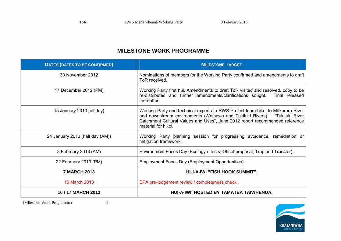
ToR RWS Mana whenua Working Party 8 February 2013
(Milestone Work Programme) 1
MILESTONE WORK PROGRAMME
DATES (DATES TO BE CONFIRMED) MILESTONE TARGET
30 November 2012 Nominations of members for the Working Party confirmed and amendments to draft ToR received.
17 December 2012 (PM) Working Party first hui. Amendments to draft ToR visited and resolved, copy to be re-distributed and further amendments/clarifications sought. Final released thereafter.
15 January 2013 (all day) Working Party and technical experts to RWS Project team hikoi to Mākaroro River and downstream environments (Waipawa and Tukituki Rivers). “Tukituki River Catchment Cultural Values and Uses”, June 2012 report recommended reference material for hikoi.
24 January 2013 (half day (AM)) Working Party planning session for progressing avoidance, remediation or mitigation framework.
8 February 2013 (AM) Environment Focus Day (Ecology effects, Offset proposal, Trap and Transfer).
22 February 2013 (PM) Employment Focus Day (Employment Opportunities).
7 MARCH 2013 HUI-A-IWI “FISH HOOK SUMMIT”.
15 March 2013 EPA pre-lodgement review / completeness check.
16 / 17 MARCH 2013 HUI-A-IWI, HOSTED BY TAMATEA TAIWHENUA.
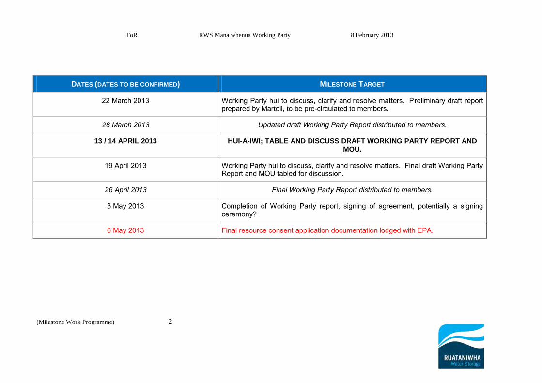
ToR RWS Mana whenua Working Party 8 February 2013
(Milestone Work Programme) 2
DATES (DATES TO BE CONFIRMED) MILESTONE TARGET
22 March 2013 Working Party hui to discuss, clarify and resolve matters. Preliminary draft report prepared by Martell, to be pre-circulated to members.
28 March 2013 Updated draft Working Party Report distributed to members.
13 / 14 APRIL 2013 HUI-A-IWI; TABLE AND DISCUSS DRAFT WORKING PARTY REPORT AND MOU.
19 April 2013 Working Party hui to discuss, clarify and resolve matters. Final draft Working Party Report and MOU tabled for discussion.
26 April 2013 Final Working Party Report distributed to members.
3 May 2013 Completion of Working Party report, signing of agreement, potentially a signing ceremony?
6 May 2013 Final resource consent application documentation lodged with EPA.
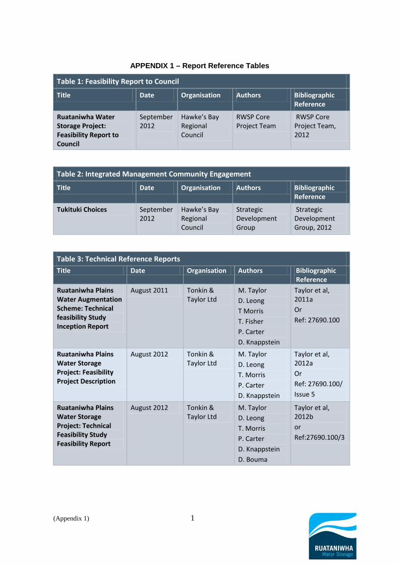
(Appendix 1) 1
APPENDIX 1 – Report Reference Tables
Table 1: Feasibility Report to Council
Title Date Organisation Authors Bibliographic Reference
Ruataniwha Water Storage Project: Feasibility Report to Council
September 2012
Hawke’s Bay Regional Council
RWSP Core Project Team
RWSP Core Project Team, 2012
Table 2: Integrated Management Community Engagement
Title Date Organisation Authors Bibliographic Reference
Tukituki Choices September 2012
Hawke’s Bay Regional Council
Strategic Development Group
Strategic Development Group, 2012
Table 3: Technical Reference Reports Title Date Organisation Authors Bibliographic
Reference Ruataniwha Plains Water Augmentation Scheme: Technical feasibility Study Inception Report
August 2011 Tonkin & Taylor Ltd
M. Taylor D. Leong T Morris T. Fisher P. Carter D. Knappstein
Taylor et al, 2011a Or Ref: 27690.100
Ruataniwha Plains Water Storage Project: Feasibility Project Description
August 2012 Tonkin & Taylor Ltd
M. Taylor D. Leong T. Morris P. Carter D. Knappstein
Taylor et al, 2012a Or Ref: 27690.100/ Issue 5
Ruataniwha Plains Water Storage Project: Technical Feasibility Study Feasibility Report
August 2012 Tonkin & Taylor Ltd
M. Taylor D. Leong T. Morris P. Carter D. Knappstein D. Bouma
Taylor et al, 2012b or Ref:27690.100/3

(Appendix 1) 2
Table 3: Technical Reference Reports Title Date Organisation Authors Bibliographic
Reference Ruataniwha Water Augmentation Scheme: Stage 1 - Geotechnical Factual Report A7 Makaroro
June 2011 Tonkin & Taylor Ltd
D. Leong M. Thomas
Leong and Thomas, 2011 Or Ref: 27195.200
A7 Makaroro River dam site - Phase 1B: Updated active fault and surface rupture displacement hazard and acceleration response spectra reassessment
December 2011 GNS R. Langridge P. Villamor G. McVerry M Cabeza
Langridge et al, 2011 Or Ref: 2011/300
Ruataniwha Water Storage Project Report on Engineering Geological Investigations A7 Site, Volume 1 & 2
March 2012 Tonkin & Taylor Ltd
B. Hegan D. Bouma
Hegan and Bouma, 2012 Or Ref: 27690.200
Ruataniwha Water Storage Project Sedimentation Assessment
July 2012 Tonkin & Taylor Ltd
T. Fisher J Russell
Fisher and Russell, 2012 Or Ref: 27690.600
Ruataniwha Water Storage Project: Dam Break Analysis
July 2012 Hawke’s Bay Regional Council
C. Goodier Goodier, 2012
Ruataniwha Water Storage and Generation Value Report
February 2012 Simply Energy M. Dyer Dyer, 2012
Table 4: Modelling Studies
Title Date Organisation Authors Bibliographic Reference
Ruataniwha Plains Water Storage Project: Characterisation of Reservoir Water Quality
July 2012 NIWA M. Gibbs C. McBride D. Ozkundakci D. Hamilton
Gibbs et al, 2012
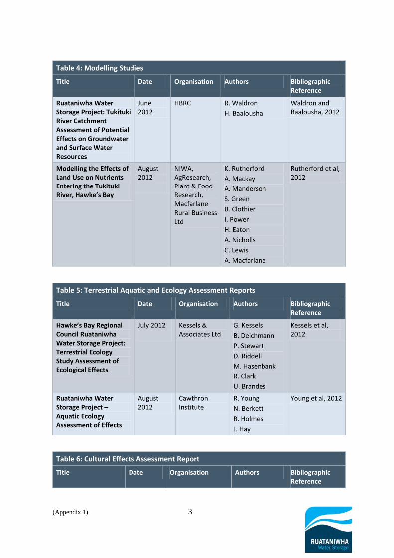
(Appendix 1) 3
Table 4: Modelling Studies
Title Date Organisation Authors Bibliographic Reference
Ruataniwha Water Storage Project: Tukituki River Catchment Assessment of Potential Effects on Groundwater and Surface Water Resources
June 2012
HBRC R. Waldron H. Baalousha
Waldron and Baalousha, 2012
Modelling the Effects of Land Use on Nutrients Entering the Tukituki River, Hawke’s Bay
August 2012
NIWA, AgResearch, Plant & Food Research, Macfarlane Rural Business Ltd
K. Rutherford A. Mackay A. Manderson S. Green B. Clothier I. Power H. Eaton A. Nicholls C. Lewis A. Macfarlane
Rutherford et al, 2012
Table 5: Terrestrial Aquatic and Ecology Assessment Reports
Title Date Organisation Authors Bibliographic Reference
Hawke’s Bay Regional Council Ruataniwha Water Storage Project: Terrestrial Ecology Study Assessment of Ecological Effects
July 2012
Kessels & Associates Ltd
G. Kessels B. Deichmann P. Stewart D. Riddell M. Hasenbank R. Clark U. Brandes
Kessels et al, 2012
Ruataniwha Water Storage Project – Aquatic Ecology Assessment of Effects
August 2012
Cawthron Institute
R. Young N. Berkett R. Holmes J. Hay
Young et al, 2012
Table 6: Cultural Effects Assessment Report
Title Date Organisation Authors Bibliographic Reference

(Appendix 1) 4
Table 6: Cultural Effects Assessment Report
Title Date Organisation Authors Bibliographic Reference
Cultural Impact Assessment of the Tukituki Proposed Water Storage Dams
September 2010
Te Manga Māori and Eastern Institute of Technology
Dr. B. Wakefield H. Taungakore K. Steffert J. Maaka C. Marunui U. Te Aho
Wakefield et al, 2010
Cultural Impact Assessment of the Tukituki Proposed Water Storage Dams: Supplementary Report on the Makāretu and Mākāroro Proposed Dam Sites
March 2011
Te Manga Māori and Eastern Institute of Technology
Dr. B. Wakefield J. Maaka H. Taungakore M. Hape
Wakefield et al, 2011
Ko Wai Ka Hua: Cultural Values and Uses, Cultural Impact Assessment of Lower the Tukituki Catchment
May 2012 Te Manaaki Taiao and Te Taiwhenua o Heretaunga
M. Apatu D. Moffat
Apatu et al, 2012
Tukituki River Catchment Cultural Values and Uses
June 2012 Te Taiwhenua O Tamatea in Partnership with Te Taiwhenua O Heretaunga
Benita Wakefield M. Hape J. Maaka Bruce Wakefield H Maaka M Apatu D. Moffatt D. Whitiwhiti
Wakefield et al, 2012
Table 7: Other Effects Assessment Reports
Title Date Organisation Authors Bibliographic Reference
Ruataniwha Water Storage Project: Road Infrastructure and Traffic Assessment
June 2012 OPUS International Consultants Ltd
R. Landon-Lane N. Uran A. Jones
Landon-Lane et al, 2012

(Appendix 1) 5
Table 7: Other Effects Assessment Reports
Title Date Organisation Authors Bibliographic Reference
Ruataniwha Water Storage Project: Noise Effects Assessment
July 2012 Marshall Day Acoustics
M. Halstead Halstead, 2012
Ruataniwha Irrigation Project: Archaeological Assessment
July 2012 Clough & Associates Ltd
S. Bickler R. Clough P. Parsons
Bickler et al, 2012
Ruataniwha Water Storage Project Social Impact Assessment
July 2012 Taylor Baines and Associates
N. Taylor Taylor, 2012
Ruataniwha Water Storage Project Recreation Assessment
August 2012
OPUS International Consultants Ltd
S. Morgan M. Frey
Morgan and Frey, 2012
Ruataniwha Water Storage Project Landscape and Visual Effects Assessment
August 2012
Isthmus G. Lister W. Robertson
Lister and Robertson, 2012
Table 8: Integrated Mitigation and Offset Report
Title Date Organisation Authors Bibliographic Reference
Ruataniwha Water Storage Project: Proposed Integrated Mitigation and Offset Approach
August 2012 Hawke’s Bay Regional Council
L. Coubrough G. Hansen S. Daysh G. Kessels
Coubrough et al, 2012
Table 9: Land use Intensification Working Party Report
Title Date Organisation Authors Bibliographic Reference
Ruataniwha Plains Water Storage Project: Land Use Intensification Working Party Report
August 2012 Environmental Management Services Ltd
S. Daysh Daysh, 2012
Table 10: Economic Reports
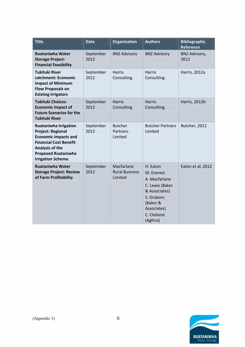
(Appendix 1) 6
Title Date Organisation Authors Bibliographic Reference
Ruataniwha Water Storage Project: Financial Feasibility
September 2012
BNZ Advisory BNZ Advisory
BNZ Advisory, 2012
Tukituki River catchment: Economic Impact of Minimum Flow Proposals on Existing Irrigators
September 2012
Harris Consulting
Harris Consulting
Harris, 2012a
Tukituki Choices: Economic Impact of Future Scenarios for the Tukituki River
September 2012
Harris Consulting
Harris Consulting
Harris, 2012b
Ruataniwha Irrigation Project: Regional Economic Impacts and Financial Cost Benefit Analysis of the Proposed Ruataniwha Irrigation Scheme.
September 2012
Butcher Partners Limited
Butcher Partners Limited
Butcher, 2012
Ruataniwha Water Storage Project: Review of Farm Profitability
September 2012
Macfarlane Rural Business Limited
H. Eaton M. Everest A. Macfarlane C. Lewis (Baker & Associates) S. Orsborn (Baker & Associates) C. Clelland (Agfirst)
Eaton et al, 2012

Page 56
Exhibit SGD 2: RWSS Part D Proposed Conditions – Updated September 2013

Ruataniwha Water Storage Scheme PART D
Proposed Conditions
May Updated September 2013
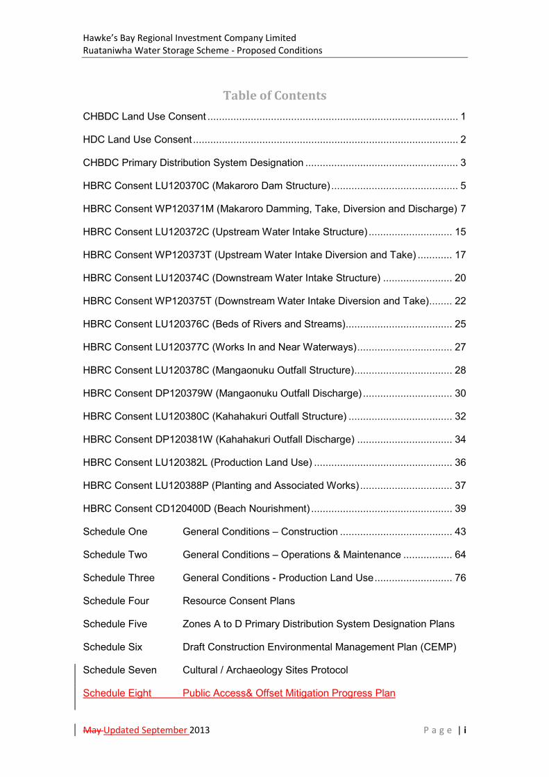
Hawke’s Bay Regional Investment Company Limited Ruataniwha Water Storage Scheme - Proposed Conditions
May Updated September 2013 P a g e | i
Table of Contents CHBDC Land Use Consent ....................................................................................... 1
HDC Land Use Consent ............................................................................................ 2
CHBDC Primary Distribution System Designation ..................................................... 3
HBRC Consent LU120370C (Makaroro Dam Structure) ............................................ 5
HBRC Consent WP120371M (Makaroro Damming, Take, Diversion and Discharge) 7
HBRC Consent LU120372C (Upstream Water Intake Structure) ............................. 15
HBRC Consent WP120373T (Upstream Water Intake Diversion and Take) ............ 17
HBRC Consent LU120374C (Downstream Water Intake Structure) ........................ 20
HBRC Consent WP120375T (Downstream Water Intake Diversion and Take) ........ 22
HBRC Consent LU120376C (Beds of Rivers and Streams) ..................................... 25
HBRC Consent LU120377C (Works In and Near Waterways) ................................. 27
HBRC Consent LU120378C (Mangaonuku Outfall Structure) .................................. 28
HBRC Consent DP120379W (Mangaonuku Outfall Discharge) ............................... 30
HBRC Consent LU120380C (Kahahakuri Outfall Structure) .................................... 32
HBRC Consent DP120381W (Kahahakuri Outfall Discharge) ................................. 34
HBRC Consent LU120382L (Production Land Use) ................................................ 36
HBRC Consent LU120388P (Planting and Associated Works) ................................ 37
HBRC Consent CD120400D (Beach Nourishment) ................................................. 39
Schedule One General Conditions – Construction ....................................... 43
Schedule Two General Conditions – Operations & Maintenance ................. 64
Schedule Three General Conditions - Production Land Use ........................... 76
Schedule Four Resource Consent Plans
Schedule Five Zones A to D Primary Distribution System Designation Plans
Schedule Six Draft Construction Environmental Management Plan (CEMP)
Schedule Seven Cultural / Archaeology Sites Protocol
Schedule Eight Public Access& Offset Mitigation Progress Plan
Hawke’s Bay Regional Investment Company Limited Ruataniwha Water Storage Scheme - Proposed Conditions
May Updated September 2013 P a g e | ii
Glossary Abbreviations and Definitions
AEP: Annual Exceedence Probability
CCTO: Council Controlled Trading Organisation
CEMP: Construction Environmental Management Plan
CFRD: Concrete Faced Rockfill Dam
CHBDC: Central Hawke’s Bay District Council
CHBDP: Central Hawke’s Bay District Plan
CTMP: Construction Traffic Management Plan
CWD: Clean Water Diversion Drains
Dam: The Proposed Makaroro Dam (on the Makaroro River) or RWSS Dam also
referred to as “the dam”, “storage dam” or “the Makaroro Dam” and
includes all facets of the dam and associated structures
D&C: Design and Construct
DEB: Decanting Earth Bund - for treating storm water runoff from areas less
than 0.3 ha
DWI: Downstream Water Intake - the point and structure at the lower end of
the Waipawa River where water released from the dam is taken to supply
Zone M
GMP: Groundwater Monitoring Plan
GMDP: Groundwater Mounding and Drainage Monitoring Plan
EAP: Emergency Action Plan
EPA: Environmental Protection Authority
FEMP: Farm Environmental Management Plan
HBRIC Ltd: Hawke’s Bay Regional Investment Company Limited
HBRC: Hawke’s Bay Regional Council
HDC: Hastings District Council
HDP: Hastings District Plan

Hawke’s Bay Regional Investment Company Limited Ruataniwha Water Storage Scheme - Proposed Conditions
May Updated September 2013 P a g e | iii
Headrace: Also referred to as “headrace canal” as part of the PDS Headrace canal
watercourse system stemming from the UWI and the DWI
IEMP: Irrigation Environmental Management Plan
ISMMP: Infrastructure Stormwater and Maintenance Management Plan
RFERP: Reservoir Filling and Edge Rehabilitation Plan
MALF: Mean Annual Low Flow
NZHPT: New Zealand Historic Places Trust
OFMP: On-Farm Monitoring Plan
Overseer: A computer model that calculates and estimates the nutrient flows in a
productive farming system and identifies risk for environmental impacts
through nutrient loss, including run off and leaching, and greenhouse gas
emissions
PC6: “Plan Change 6” or “Change 6” being the Tukituki River Catchment Plan
Change. A proposed plan change which inserts Tukituki Catchment
specific objectives, policies and rules into the RRMP
PD: Project Description. Provides a description of the proposed Ruataniwha
Water Storage Scheme, see the PD for a full description
PDS: Primary Distribution System. Comprises the primary headrace canals and
pipelines that are connected to the intake structures that provide water
to the SDS, see the PD for a full description
PLUA: Production Land Use Areas. Areas of irrigable land suitable for primary
production within the RWSS’s five command zones
Reservoir: The body of water stored behind the dam on the Makaroro River
RMA: Resource Management Act 1991
ROR: Reservoir Operating Regime
RRMP: The Hawke’s Bay Regional Resource Management Plan (generally
referred to as the “regional plan”)
RPS: The Hawke’s Bay Regional Policy Statement (forms part of the RRMP)
Hawke’s Bay Regional Investment Company Limited Ruataniwha Water Storage Scheme - Proposed Conditions
May Updated September 2013 P a g e | iv
RPS Change 5: Regional Policy Statement Change 5 “Land use and freshwater
management”
RWSS: Ruataniwha Water Storage Scheme (also referred to as “the Scheme” or
“RWS Scheme”
SDS: Secondary Distribution System. Comprises of a network of pipelines that
are connected to the PDS that deliver water to properties i.e. “the farm
gate”, see the PD for a full description
SCEMP: Supplementary Construction Environmental Management Plan
SMP: Sediment Management Plan
SRP: Sediment retention pond – for treating storm water from areas greater
than 0.3 ha up to 5.0 ha
TRIM: Tukituki River Model. A computer model incorporating models,
environmental data and GIS used to manage nutrient inputs, land use and
water quality
WDN: Water Distribution Network. Comprises of the PDS and SDS, see the PD
for a full description
WLSP: Water Level Safety Plan
UWI: Upstream Water Intake. The point and structure at the upper end of the
Waipawa River where water released from the dam is taken to supply
Zones A, B, C and D
Zone: An area labelled A, B, C, D or M that the scheme is providing water to.
Also referred to as “command zones”. The word zone is also used in
relation to zones in planning maps in the CHBDP and HDP and can be
used in different contexts

Hawke’s Bay Regional Investment Company Limited Ruataniwha Water Storage Scheme - Proposed Conditions
May Updated September 2013 P a g e | 1
CHBDC Land Use Consent
Consent Type: Land Use Consent.
Activity Authorised: All uses of land associated with the construction, operation
and maintenance of:
A water storage dam and the part of the associated
reservoir within the Central Hawke’s Bay District on the
Makaroro River at Wakarara approximately 35km
northwest of Waipawa including facilities for the
generation of electricity and an associated transformer;
Two water intake structures adjacent to the Waipawa
River;
A water outfall structure adjacent to the Mangaonuku
Stream;
A water outfall structure adjacent to the Kahahakuri
Stream; and
All associated works, earthworks (including gravel
extraction), vegetation clearance, construction of roads
and tracks, structures, proposed plantings, storage and
use of hazardous substances, and ancillary activities to
the extent required by the Central Hawke’s Bay District
Plan (including but not limited to the modification of
Areas of Significant Nature Conservation Value) within
the Central Hawke’s Bay District.
Within the areas shown on Plans 1 – 7 in Schedule Four but
excluding the Zone A to D primary headrace canals and
pipelines which are the subject of a separate designation.
Conditions:
1. The exercise of this consent is subject to compliance with the conditions specified in
Schedule One in relation to construction activities and Schedule Two attached in
relation to operations and maintenance activities.
Hawke’s Bay Regional Investment Company Limited Ruataniwha Water Storage Scheme - Proposed Conditions
May Updated September 2013 P a g e | 2
HDC Land Use Consent
Consent Type: Land Use Consent.
Activity Authorised: The establishment and operation of part of a water reservoir
on, and in the vicinity of, the Makaroro River within the
Hastings District north of Wakarara (adjacent to the
boundary of the Hastings and Central Hawke’s Bay Districts)
approximately 35km northwest of Waipawa within the areas
shown on Plans 1 and 2 in Schedule Four, and including all
earthworks and mining, vegetation clearance, construction
of roads and tracks, proposed plantings, and other
associated works and ancillary activities within the Hastings
District.
Conditions:
1. The exercise of this consent is subject to compliance with the conditions specified in
Schedule One in relation to construction activities and Schedule Two attached in
relation to operations and maintenance activities.

Hawke’s Bay Regional Investment Company Limited Ruataniwha Water Storage Scheme - Proposed Conditions
May Updated September 2013 P a g e | 3
CHBDC Primary Distribution System Designation
Purpose of designation: Ruataniwha Water Storage Scheme - Primary Distribution
System (Zones A-D).
Location of designated land: The site to which the requirement applies is located on the
Ruataniwha Plains to the northwest, west and southwest of
Waipawa and Waipukurau as follows:
A corridor of land running from a point to the north of the
Waipawa River in the vicinity of Makaroro Road and then
extending north along State Highway 50 to the
intersection with Smedley Road and Butler Road;
A corridor of land running from a point to the south of
the Waipawa River, initially running alongside the true
right bank of the river and then heading in a generally
southern direction to Oruawhara Road to the east of
Takapau; and
The corridor of land is a maximum of 100 metres wide
and an average of approximately 60 metres wide where
the primary distribution system headrace canal is
proposed, and a maximum of 25 m wide where primary
distribution system pipeline is proposed (apart from the
area where the primary distribution system headrace
canal meets the primary distribution system pipeline).
The land which is the subject of this Notice of Requirement is
shown on NOR Plans 1 to 11 in Schedule Five.
Conditions:
1. The exercise of this designation is subject to compliance with the conditions
specified in Schedule One attached in relation to construction activities and
Schedule Two attached in relation to operations and maintenance activities.
2. The requiring authority shall submit an outline plan or plans to CHBDC pursuant to
section 176A of the Resource Management Act 1991 prior to the commencement of
construction works, which shall include (without limitation) details of the final
Hawke’s Bay Regional Investment Company Limited Ruataniwha Water Storage Scheme - Proposed Conditions
May Updated September 2013 P a g e | 4
design and the location of access points across the primary distribution system
headrace canal to maintain access for property owners. In preparing the outline
plan(s) the requiring authority shall consult with each landowner and implement as
far as practicable the “Headrace Design Principles” as set out in the Landscape and
Visual Assessment Report supplied with the Applications - Isthmus (May 2013).
2. After completion of the detailed design of the Zone A to D primary distribution
system headrace canal and pipeline and following consultation with the relevant
landowner(s) and occupiers, the necessary easement width will be determined within
the designated area. The requiring authority shall uplift the designation in relation to
any part of the designation that will not be utilised (i.e. the land beyond any final
easement area) within 3 calendar months of the all the final easement areas for the
works being determined.
[Notes:
a) The intention is to split out the conditions in Schedule One and Two relevant
to the designation into this set of conditions once the final content of those
Schedule One and Two conditions have been confirmed after the release of a
Draft Board of Inquiry Decision]
a)b)The Outline Plan requirements have been deleted from these conditions and
transferred to updated condition 13 in Schedule One, responding to the
submission by CHBDC regarding their concern over duplication of the Outline
Plan and SCEMP processes.]

Hawke’s Bay Regional Investment Company Limited Ruataniwha Water Storage Scheme - Proposed Conditions
May Updated September 2013 P a g e | 5
HBRC Consent LU120370C (Makaroro Dam Structure)
Consent Type: Land use consent, water permit, and discharge permit. Map Reference: Dam Crest – at or about E1880627 N5592232 (NZTM).
Activity Authorised: Construction, operation and maintenance of a dam on the
Makaroro River at Wakarara approximately 35km northwest
of Waipawa within the areas shown on Plans 1 – 3 in
Schedule Four forming part of the Ruataniwha Water
Storage Scheme, including the associated:
Placement of the dam and all associated structures on
the river bed, and consequent occupation of the river bed
by the same;
Earthworks and the clearance of any vegetation
associated with construction activities;
Disturbance of the bed of the river including any
excavation, drilling and tunnelling;
Removal of river bed sediment, gravel and sand and
deposition of spoil associated with construction activities
and on an ongoing basis to maintain the operational
integrity of the dam water intake structure within the
reservoir;
Damming, diversion, take and discharge of water and
contaminants including water-borne sediment to land
and water associated with construction activities;
Discharges to air associated with construction activities;
Diversion and discharge of stormwater; and
All associated works and ancillary activities.
Consent Duration: 35 years from the date of grant
Hawke’s Bay Regional Investment Company Limited Ruataniwha Water Storage Scheme - Proposed Conditions
May Updated September 2013 P a g e | 6
Conditions:
Construction, Operations and Maintenance Activities
1. The exercise of this consent is subject to compliance with the conditions specified in
Schedule One attached in relation to construction activities and Schedule Two
attached in relation to operations and maintenance activities.
Management of Accumulating Sediment
2. The consent holder shall engage a Registered Professional Surveyor to survey the bed
of the reservoir formed behind the Makaroro Dam prior to reservoir filling and then
at intervals of not more than three years thereafter. The survey shall have a
maximum grid spacing of 50 metres in any direction. The farthest survey point from
the Dam structure shall be located at the intersection of the river bed at the Dam’s
full supply level of 469.5 m RL (Hawke’s Bay Datum).
3. Within one calendar month of completion of each survey under condition 2 of this
consent after reservoir filling, the consent holder shall calculate the storage capacity
of the reservoir relative to the first survey and supply the results of that calculation to
the HBRC Group Manager, Resource Management.
4. If the survey results supplied under condition 2 of this consent show that the storage
capacity of the reservoir has reduced relative to the first survey by more than
3,500,000 cubic metres by reason of accumulating sediment, the consent holder shall
engage an independent expert qualified and experienced in management of reservoir
and riverbed sediment to provide a report not later than six calendar months
following receipt by the consent holder of the bed survey results identifying options
to manage or prevent further accumulation of sediment and consequential loss of
reservoir storage capacity, where this is necessary to ensure:
a) Sufficient storage capacity is available to meet irrigation demands at the
contracted security of supply; and
b) Compliance with conditions 6 to 11 of Resource Consent WP120371M.
5. A copy of the expert’s report, together with the consent holder’s response to the
experts recommended options, the options it proposes to implement and the
timeframe(s) for their implementation, shall be supplied to the HBRC Group
Manager, Resource Management, with a copy to CHBDC and HDC, within one
calendar month after it is received by the consent holder.

Hawke’s Bay Regional Investment Company Limited Ruataniwha Water Storage Scheme - Proposed Conditions
May Updated September 2013 P a g e | 7
HBRC Consent WP120371M (Makaroro Damming, Take, Diversion and Discharge)
Consent type: Water permit and discharge permit. Map Reference: Dam Crest – at or about E1880627 N5592232 (NZTM).
Activity Authorised: Damming, taking, diverting, use (for the purposes of
electricity generation) and discharging of water and water-
borne sediment to water associated with the operation of
the Makaroro Dam at Wakarara approximately 35km
northwest of Waipawa within the areas shown on Plans 1 – 3
in Schedule Four as part of the operation of the Ruataniwha
Water Storage Scheme.
Consent Duration: 35 years from the date of grant.
Conditions:
General
1. The activities authorised by this consent shall be undertaken in general accordance
with the Ruataniwha Water Storage Scheme application for resource consents and
notice of requirement lodged by the Hawke’s Bay Regional Investment Company
Limited, dated 6 May 2013.
2. Pursuant to Section 125(1) of the Resource Management Act 1991, this consent will
lapse if not given effect to within 10 years of the commencement of the consents.
3. The consent holder shall be responsible for compliance with these conditions. The
purpose of the conditions is both to set out the obligations of the consent holder
and to describe the process by which the consent holder shall ensure that those
obligations are met.
4. The exercise of this consent is subject to compliance with the conditions specified in
Schedule Two attached in relation to operations and maintenance activities.
Reservoir Level Control
5. Control of reservoir levels shall be undertaken such that the normal operating
maximum reservoir level shall be 469.5mRL (based on a 3 hour rolling average), as
measured at the Makaroro Dam.
Hawke’s Bay Regional Investment Company Limited Ruataniwha Water Storage Scheme - Proposed Conditions
May Updated September 2013 P a g e | 8
Environmental Flows
6. A minimum discharge of 1.23 m3/s shall be maintained below the Makaroro Dam at
all times, as measured:
a) At the outlet works (including operation of the turbine and residual flow);
and
b) At the spillway (indirectly via recorded reservoir levels).
7. The consent holder shall release water from the Dam as required to ensure that the
security of supply to third party resource consent holders is not adversely affected
by an increase in the number of days on which the flow at the Waipawa at RDS flow
measurement site and Tukituki at Red Bridge flow measurement site drops below
the minimum flows fixed in the Hawke’s Bay Regional Resource Management Plan as
a result of the exercise of this consent in conjunction with Resource Consents
WP120373T, WP120375T, DP120379W, and DP120381W.
8. In order to identify what flow releases are required to be made pursuant to
condition 7 above, and to demonstrate compliance with that condition:
a) The consent holder shall maintain a model, certified by the HBRC Group
Manager Resource Management as fit for purpose, that determines the
combined effect of damming, diversion, taking, use and discharge of water
pursuant to Resource Consents WP120373T, WP120375T, DP120379W, and
DP120381W and this Resource Consent , on the security of supply to third
party resource consent holders subject to the Red Bridge Minimum Flow
established by HBRC Proposed Plan Change 6, relative to the position if
Resource Consents WP120373T, WP120375T, DP120379W, and DP120381W
and this consent were not being exercised. A report of the results of the
model simulation of the catchment and of the flows released to comply with
this condition shall be provided to the HBRC Group Manager Resource
Management each year not later than 31 July in respect of the 12 months
ended the previous 30 June; and
b) In relation to the Waipawa at RDS flow measurement site, when measured
flows at that site are within 2% of the Minimum Flow established by HBRC
Proposed Plan Change 6 and dropping, the consent holder shall discharge
from the dam a volume and rate of flow matching the inflows to the

Hawke’s Bay Regional Investment Company Limited Ruataniwha Water Storage Scheme - Proposed Conditions
May Updated September 2013 P a g e | 9
Makaroro Dam reservoir or 1.23 m3/s (whichever is the greater) until such
time as measured flows at the Waipawa at RDS flow measurement site are
102% of the Minimum Flow at that site or greater.
In either case, if the inflows into the Makaroro Dam reservoir are greater than
1.8m3/s the consent holder shall be under no obligation to release water for the
purposes of condition 7 and this condition.
9. The consent holder shall consult with the holders of HBRC resource consents
WP110302T and WP120230T to establish a protocol to ensure that the water
storage systems serviced by those consents are not materially compromised by the
exercise of this consent in conjunction with Resource Consents WP120373T,
WP120375T, DP120379W, and DP120381W. The protocol required by this condition
shall utilise the model maintained in accordance with condition 8 a) of this consent
to establish the effect of the exercise of this consent in conjunction with Resource
Consents WP120373T, WP120375T, DP120379W, and DP120381W.
9. If no third party water permit holders are subject to the Waipawa at RDS Minimum
Flow or alternatively if all water permit holders subject to the Waipawa at RDS
Minimum Flow provide their written consent the consent holder shall not be
required to release water to meet the requirements of condition 8 b) above.
10. The consent holder shall release water from the dam up to a maximum of 1 million
cubic metres for each release, with the objective of mitigating the build-up of
periphyton downstream (flushing flows). These flushing flows shall occur up to four
times during the period 15 December and the following 30 April.
11. Water released during flushing flows shall not be taken under Resource Consent
WP120373T or WP120375T for irrigation and/or water supply purposes
downstream. The discharge of flushing flows pursuant to this condition shall be
undertaken in accordance with the following requirements:
a) No flushing flows are required to be released while flows measured at the
HBRC flow monitoring site at Red Bridge exceed 50 m3/s (the ‘trigger flow’)
or within the period of 20 days thereafter;
b) Between 20 days and 30 days following a trigger flow event, if the measured
flow at Red Bridge exceeds 15 m3/s as a result of natural freshes in the river
system, the consent holder shall release a flushing flow for a period of 9.25
Hawke’s Bay Regional Investment Company Limited Ruataniwha Water Storage Scheme - Proposed Conditions
May Updated September 2013 P a g e | 10
hours. The flushing flow shall be the lesser of 30 m3/s and the difference
between 50 m3/s and flow recorded at Red Bridge at the commencement of
the flushing flow release;
c) If no flushing flow release is made under condition 11b) within 30 days of
the last trigger flow, the consent holder shall release a flushing flow of 30
m3/s for a period of 9.25 hours; and
d) Where the Dam is unable to physically release the flushing flow required in
conditions 11 a) to c) above, the flow that is able to be released shall be
released over a proportionately longer period, up to a maximum of 12
hours, so that one million cubic metres is released during any flushing flow.
12. The consent holder shall monitor periphyton cover, including the presence and
relative abundance of Phormidium Spp. before and after flushing flows released
pursuant to conditions 10 and 11 of this consent as follows:
a) Monitoring shall occur before and after each flushing flow released during
the first year of irrigation releases from the dam, then before and after two
flushing flow releases during the following four years, and before and after
at least one flushing flow each year thereafter for the balance of the term of
this consent as specified below:
i. The monitoring shall be undertaken no more than 48 hours before the
beginning, and no more than 48 hours after the end, of each flushing
flow;
ii. The monitoring shall follow the RAM-1 method contained in the “stream
periphyton manual” (Biggs and Kilroy, 2000)1 or such similar method
approved by the HBRC Group Manager, Resource Management;
iii. The monitoring shall be undertaken at no less than;
1 site on the Makaroro River between the toe of the dam and the
confluence with the Waipawa River
2 sites on the Waipawa River between the confluence with the
Makaroro River and the confluence with the Tukituki River
1 Biggs, B.J.F. and Kilroy C. (2000). Stream periphyton monitoring manual. Prepared for the Ministry for the Environment by NIWA, Christchurch. ISBN 0-478-09099-4
Hawke’s Bay Regional Investment Company Limited Ruataniwha Water Storage Scheme - Proposed Conditions
May Updated September 2013 P a g e | 11
4 sites on the lower Tukituki River between the confluence with the
Waipawa River and the Black Bridge monitoring site.
b) The location of the monitoring sites shall be determined annually in
consultation with the District Health Board.
Reservoir Water Quality
13. The Consent holder shall implement a reservoir water quality monitoring
programme at a point in the reservoir located at or near the deepest point in the
reservoir for the monitoring parameters and frequency specified in Table 1 below.
Unless otherwise specified in the conditions of this consent, the monitoring
protocols shall follow the protocols described in the Ministry for the Environment
report “Protocol for monitoring trophic levels of New Zealand lakes and reservoirs”
(Burns et al. 2000).
Table 1
Type Monitoring parameter Frequency
Laboratory Analysis
(Water samples taken at three representative depths using a Van Dorne-type sampling apparatus)
Nitrate Nitrogen
Monthly
Total Ammoniacal Nitrogen
Total Nitrogen
Total Carbon
DRP
Total Phosphorus
Algal abundance (cell count)
Algal abundance (biovolume)
Field Measurements
(depth profiles)
Visual clarity (Secchi depth) Monthly
Temperature
Dissolved Oxygen (g/m3 and % saturation)
Conductivity
Turbidity
Chlorophyll fluorescence
Phytocyanin
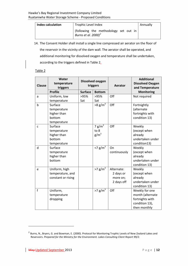
Hawke’s Bay Regional Investment Company Limited Ruataniwha Water Storage Scheme - Proposed Conditions
May Updated September 2013 P a g e | 12
Index calculation Trophic Level Index
(following the methodology set out in Burns et al. 2000)2
Annually
14. The Consent Holder shall install a single line compressed air aerator on the floor of
the reservoir in the vicinity of the dam wall. The aerator shall be operated, and
additional monitoring for dissolved oxygen and temperature shall be undertaken,
according to the triggers defined in Table 2.
Table 2
Clause
Water temperature
triggers
Dissolved oxygen triggers Aerator
Additional Dissolved Oxygen and Temperature
Monitoring Profile Surface Bottom a Uniform, low
temperature >95% Sat
>95% Sat
Off Not required
b Surface temperature higher than bottom temperature
>8 g/m3 Off Fortnightly (alternate fortnights with condition 13)
c Surface temperature higher than bottom temperature
7 g/m3 to 8 g/m3
Off Weekly (except when already undertaken under condition13)
d Surface temperature higher than bottom
<7 g/m3 On continuously
Weekly (except when already undertaken under condition 13)
e Uniform, high temperature, and constant or rising
>7 g/m3 Alternate: 2 days or more on; 2 days off
Weekly (except when already undertaken under condition 13)
f Uniform, temperature dropping
>7 g/m3 Off Weekly for one month (alternate fortnights with condition 13), then monthly
2 Burns, N., Bryers, G. and Bowman, E. (2000). Protocol for Monitoring Trophic Levels of New Zealand Lakes and Reservoirs. Prepared for the Ministry for the Environment. Lakes Consulting Client Report 99/2.

Hawke’s Bay Regional Investment Company Limited Ruataniwha Water Storage Scheme - Proposed Conditions
May Updated September 2013 P a g e | 13
15. The consent holder shall provide an annual report in July on the actions taken to
comply with conditions 6 to 14 over the twelve month period ending 30 April to the
HBRC Group Manager, Resource Management. Where data is provided it shall be in
a form compatible with the HBRC data systems.
Pre and Post Dam Construction Eel Monitoring
16. The consent holder shall engage a suitably qualified and experienced freshwater
aquatic ecologist to investigate and report on the size structure of the eel population
in the Makaroro River upstream of the proposed dam before and after dam
construction to determine if the trap and transfer programme required under
Condition 1 of Schedule Two of these conditions as part of Project C of the
Integrated Mitigation and Offset Approach Report submitted with the application –
HBRIC (May 2013f) is enabling successful recruitment of young eels to the reservoir
and river above the dam. The investigation shall be undertaken prior to dam
construction and at five yearly intervals after construction over the duration of the
consent.
17. A copy of the report prepared from each sampling occasion under Condition 15
above shall be provided to the HBRC Group Manager – Resource Management
within 3 calendar months of the sampling.
Review
16.18. The Consent Authorities may, during the March to June period within every
year that this consent is current, serve notice on the consent holder under section
128(1) of the Resource Management Act 1991, of its intention to review the
conditions of consent for the following purposes:
a) To review the effectiveness of the conditions of the consent in avoiding,
remedying or mitigating any adverse effects on the environment from the
exercise of the consent and if necessary to avoid, remedy or mitigate such
effects by way of further or amended conditions;
b) To ensure that the conditions are consistent with any policies or rules in a
regional plan or National Environmental Standard or Regulation that becomes
legally effective after grant of consent; or
c) To review the adequacy of and the necessity for monitoring undertaken by the
consent holder.

Hawke’s Bay Regional Investment Company Limited Ruataniwha Water Storage Scheme - Proposed Conditions
May Updated September 2013 P a g e | 14
Administration
17.19. The Consent Holder shall pay to the Consent Authorities any administrative
charge fixed in accordance with section 36 of the Resource Management Act 1991,
or any charge prescribed in accordance with regulations made under section 360 of
the Resource Management Act 1991.

Hawke’s Bay Regional Investment Company Limited Ruataniwha Water Storage Scheme - Proposed Conditions
May Updated September 2013 P a g e | 15
HBRC Consent LU120372C (Upstream Water Intake Structure)
Consent Type: Land use consent, water permit, and discharge permit.
Map Reference: At or about E1890317 N5584739 (NZTM).
Activity Authorised: Construction, operation and maintenance of water intake
facilities on the true right bank of the Waipawa River near
Makaroro Road approximately 4.5km west of State Highway
50 (referred to as the ‘Upstream Water Intake Structure’)
within the area shown on Plan 4 in Schedule Four forming
part of the Ruataniwha Water Storage Scheme, including the
associated:
Placement of the water intake and associated structures
on the river bed, and consequent occupation of the river
bed by the same;
Earthworks and the clearance of any vegetation
associated with construction activities;
Disturbance of the bed of the river including any
excavation, drilling and tunnelling associated with
construction activities;
Damming, diversion, take and discharge of water and
contaminants including water-borne sediment to land
and water associated with construction activities;
Discharges to air associated with construction activities;
Ongoing (post construction) disturbance and excavation
of the river bed to maintain the river channel (flow and
level) at the intake location and to manage the deposition
of sediment at the intake location;
Excavation and flushing of accumulated sediment;
Diversion and discharge of stormwater; and
All associated works and ancillary activities
Consent Duration: 35 years from the date of grant.

Hawke’s Bay Regional Investment Company Limited Ruataniwha Water Storage Scheme - Proposed Conditions
May Updated September 2013 P a g e | 16
Conditions:
1. The exercise of this consent is subject to compliance with the conditions specified in
Schedule One attached in relation to construction activities and Schedule Two
attached in relation to operations and maintenance activities.
Hawke’s Bay Regional Investment Company Limited Ruataniwha Water Storage Scheme - Proposed Conditions
May Updated September 2013 P a g e | 17
HBRC Consent WP120373T (Upstream Water Intake Diversion and Take)
Consent Type: Water permit.
Map Reference: At or about E1890317 N5584739 (NZTM).
Activity Authorised: Diversion of water and taking up to 11.1 m3/s of water from
the Waipawa River near Makaroro Road approximately
4.5km west of State Highway 50, within the areas shown on
Plans 1 and 4 in Schedule Four, and to subsequently take the
same water from the water distribution network and to use
that water for water supply, including for irrigation purposes
on production land, as part of the operation of the
Ruataniwha Water Storage Scheme, within:
The areas located on the Ruataniwha Plains identified as
Zones A – D to the west of Waipawa and Waipukurau
shown on Plan 8 in Schedule Four; and
Other properties beyond the area covered by Consent
LU120382L (shown on Plans 8 and 9) which are the
subject of an existing Water Permit as shown on Plan 10
in Schedule Four.
Consent Duration: 35 years from the date of grant.
Conditions:
General
1. The activities authorised by this consent shall be undertaken in general accordance
with the Ruataniwha Water Storage Scheme application for resource consents and
notice of requirement lodged by the Hawke’s Bay Regional Investment Company
Limited, dated 6 May 2013.
2. Pursuant to Section 125(1) of the Resource Management Act 1991, this consent will
lapse if not given effect to within 10 years of the commencement of the consents.
3. The consent holder shall be responsible for compliance with these conditions. The
purpose of the conditions is both to set out the obligations of the consent holder
and to describe the process by which the consent holder shall ensure that those
obligations are met.
Hawke’s Bay Regional Investment Company Limited Ruataniwha Water Storage Scheme - Proposed Conditions
May Updated September 2013 P a g e | 18
4. The exercise of this consent is subject to compliance with the conditions specified in
Schedule Two attached in relation to operations and maintenance activities.
Fish Passage
5. The arrangements for water take pursuant to this consent shall ensure fish exclusion
to a standard consistent with the NIWA Fish Screening Good Practice Guidelines,
October 2007.
6. The consent holder shall engage an appropriately qualified aquatic ecologist to
assess the performance of the intake as a means of compliance with condition 5
above and shall report to the HBRC Group Manager, Resource Management within 3
calendar months of the consent being exercised. If that report identifies that
condition 5 is not being met then within a further 3 calendar months the consent
holder shall undertake remedial works recommended by the aquatic ecologist to
achieve compliance with condition 5. Following the completion of the
recommended remedial works the consent holder shall provide a certificate to the
HBRC Group Manager, Resource Management from the aquatic ecologist that these
works meet condition 5.
Take Volume
7. The volume and rate of water taken pursuant to this consent shall not be greater
than the volume and rate of water discharged pursuant to Resource Consent
WP120371M, less the minimum discharge and any additional flows discharged to
meet the requirements of conditions 6 to 11 of that permit.
Water Use Condition
8. The use component of this consent is subject to compliance with the conditions
specified in Schedule Three attached.
Review
9. The Consent Authorities may, during the March to June period within every year
that this consent is current, serve notice on the consent holder under section 128(1)
of the Resource Management Act 1991, of its intention to review the conditions of
consent for the following purposes:
a) To review the effectiveness of the conditions of the consent in avoiding,
remedying or mitigating any adverse effects on the environment from the

Hawke’s Bay Regional Investment Company Limited Ruataniwha Water Storage Scheme - Proposed Conditions
May Updated September 2013 P a g e | 19
exercise of the consent and if necessary to avoid, remedy or mitigate such
effects by way of further or amended conditions;
b) To ensure that the conditions are consistent with any policies or rules in a
regional plan or National Environmental Standard or Regulation that becomes
legally effective after grant of consent; or
c) To review the adequacy of and the necessity for monitoring undertaken by the
consent holder.
Administration
10. The Consent Holder shall pay to the Consent Authorities any administrative charge
fixed in accordance with section 36 of the Resource Management Act 1991, or any
charge prescribed in accordance with regulations made under section 360 of the
Resource Management Act 1991.
.
Hawke’s Bay Regional Investment Company Limited Ruataniwha Water Storage Scheme - Proposed Conditions
May Updated September 2013 P a g e | 20
HBRC Consent LU120374C (Downstream Water Intake Structure)
Consent Type: Land use consent, water permit, and discharge permit.
Map Reference: At or about E1910480 N5569497 (NZTM).
Activity Authorised: Construction, operation and maintenance of water intake
facilities on the true left bank of the Waipawa River near the
southern end of Walker Road approximately 1km upstream
of the confluence with the Tukituki River (referred to as the
‘Downstream Water Intake Structure’) within the area
shown on Plan 5 in Schedule Four forming part of the
Ruataniwha Water Storage Scheme, including the
associated:
Placement of the water intake and associated structures
on the river bed, and consequent occupation of the river
bed by the same;
Earthworks and the clearance of any vegetation
associated with construction activities;
Disturbance of the bed of the river including any
excavation, drilling and tunnelling associated with
construction activities;
Damming, diversion, take and discharge of water and
contaminants including water-borne sediment to land
and water associated with construction activities;
Discharges to air associated with construction activities;
Ongoing (post construction) disturbance and excavation
of the river bed to maintain the river channel (flow and
level) at the intake location and to manage the deposition
of sediment at the intake location;
Excavation and flushing of accumulated sediment;
Diversion and discharge of stormwater; and
All associated works and ancillary activities.
Consent Duration: 35 years from the date of grant.

Hawke’s Bay Regional Investment Company Limited Ruataniwha Water Storage Scheme - Proposed Conditions
May Updated September 2013 P a g e | 21
Conditions:
1. The exercise of this consent is subject to compliance with the conditions specified in
Schedule One attached in relation to construction activities and Schedule Two
attached in relation to operations and maintenance activities.
Hawke’s Bay Regional Investment Company Limited Ruataniwha Water Storage Scheme - Proposed Conditions
May Updated September 2013 P a g e | 22
HBRC Consent WP120375T (Downstream Water Intake Diversion and Take)
Consent Type: Water permit.
Map Reference: At or about E1910480 N5569497 (NZTM).
Activity Authorised: Diversion of water and taking up to 1.82 m3/s of water from
the Waipawa River near the southern end of Walker Road
approximately 1km upstream of the confluence with the
Tukituki River, within the areas shown on Plans 1 and 5 in
Schedule Four, and to discharge that water into a primary
distribution system (being the old Waipawa River bed /
Papanui Stream) and to subsequently take the same water
from the Zone M Primary Distribution headrace and to use
that water for water supply, including for irrigation purposes
on production land within the area located on the
Ruataniwha Plains identified as Zone M to the east of
Waipawa as shown on Plan 9 in Schedule Four, forming part
of the operation of the Ruataniwha Water Storage Scheme.
Consent Duration: 35 years from the date of grant.
Conditions:
General
1. The activities authorised by this consent shall be undertaken in general accordance
with the Ruataniwha Water Storage Scheme application for resource consents and
notice of requirement lodged by the Hawke’s Bay Regional Investment Company
Limited, dated 6 May 2013.
2. Pursuant to Section 125(1) of the Resource Management Act 1991, this consent will
lapse if not given effect to within 10 years of the commencement of the consents.
3. The consent holder shall be responsible for compliance with these conditions. The
purpose of the conditions is both to set out the obligations of the consent holder
and to describe the process by which the consent holder shall ensure that those
obligations are met.
4. The exercise of this consent is subject to compliance with the conditions specified in
Schedule Two attached in relation to operations and maintenance activities.
Hawke’s Bay Regional Investment Company Limited Ruataniwha Water Storage Scheme - Proposed Conditions
May Updated September 2013 P a g e | 23
Fish Passage
5. The arrangements for water take pursuant to this consent shall ensure adult trout
exclusion.
6. The consent holder shall engage an appropriately qualified aquatic ecologist to
assess the performance of the intake in terms of compliance with condition 5 above
and report to the consent holder and the HBRC Group Manager, Resource
Management within 3 calendar months of the consent being exercised. If that
report identifies that condition 5 is not being met then within a further 3 calendar
months the consent holder shall undertake remedial works recommended by the
aquatic ecologist to achieve compliance with condition 5. Following the completion
of the recommended remedial works the consent holder shall provide a certificate
to the HBRC Group Manager, Resource Management from the aquatic ecologist that
these works meet condition 5.
Take and Discharge Volume
7. Following first exercise of this consent, the consent holder shall take and discharge a
minimum of 50 litres/second to the Zone M Primary Distribution headrace which
shall not be subsequently taken by the consent holder (or third party water permit
holders by arrangement with the consent holder) for irrigation and/or water supply
purposes downstream. Provided that when the natural flow of the Papanui Stream
at Newmans Ford is greater than 3000 litres per second, the consent holder shall
cease discharging pursuant to this consent.
8. The volume and rate of water taken pursuant to this consent for irrigation use
and/or water supply purposes shall not be greater than the volume and rate of
water discharged pursuant to Resource Consent DP120379W.
Water Use Condition
9. The use component of this consent is subject to compliance with the conditions
specified in Schedule Three attached.
Review
10. The Consent Authorities may, during the March to June period within every year
that this consents is current, serve notice on the consent holder under section
128(1) of the Resource Management Act 1991, of its intention to review the
conditions of consent for the following purposes:
Hawke’s Bay Regional Investment Company Limited Ruataniwha Water Storage Scheme - Proposed Conditions
May Updated September 2013 P a g e | 24
a) To review the effectiveness of the conditions of the consent in avoiding,
remedying or mitigating any adverse effects on the environment from
the exercise of the consent and if necessary to avoid, remedy or
mitigate such effects by way of further or amended conditions;
b) To ensure that the conditions are consistent with any policies or rules in
a regional plan or National Environmental Standard or Regulation that
becomes legally effective after grant of consent; or
c) To review the adequacy of and the necessity for monitoring undertaken
by the consent holder.
Administration
11. The Consent Holder shall pay to the Consent Authorities any administrative charge
fixed in accordance with section 36 of the Resource Management Act 1991, or any
charge prescribed in accordance with regulations made under section 360 of the
Resource Management Act 1991.

Hawke’s Bay Regional Investment Company Limited Ruataniwha Water Storage Scheme - Proposed Conditions
May Updated September 2013 P a g e | 25
HBRC Consent LU120376C (Beds of Rivers and Streams)
Consent Type: Land use consent, water permit, and discharge permit.
Activity Authorised: Construction, operation and maintenance of siphons,
pipelines and/or culverts associated with a water
distribution network in, on, under, and over (and within 6m
of) the beds of the following rivers and streams:
Waipawa River;
Mangaoho Stream;
Kahahakuri Stream;
Ongaonga Stream;
Tukituki River;
Tukipo River;
Makaretu River;
Porangahau Stream; and
Various tributaries to the above rivers and streams.
and including the un-named streams at the locations shown
on Plan 11 in Schedule Four, forming part of the Ruataniwha
Water Storage Scheme, including the associated:
Placement of the siphons and/or pipeline and all
associated structures under the stream and river
beds, and consequent occupation of the stream and
river beds by the same;
Earthworks and the clearance of any vegetation
associated by construction activities;
Damming, diversion, take and discharge of water
and contaminants including water-borne sediment
to land and water associated with construction
activities;
Disturbance of the bed of the stream or river,
including any excavation, drilling and tunnelling
under the stream or river bed;
Discharges to air associated with construction
activities; and

Hawke’s Bay Regional Investment Company Limited Ruataniwha Water Storage Scheme - Proposed Conditions
May Updated September 2013 P a g e | 26
Diversion and discharge of stormwater; and
All associated works and ancillary activities.
Consent Duration: 35 years from the date of grant.
Conditions:
1. The exercise of this consent is subject to compliance with the conditions specified in
Schedule One attached in relation to construction activities and Schedule Two
attached in relation to operations and maintenance activities.

Hawke’s Bay Regional Investment Company Limited Ruataniwha Water Storage Scheme - Proposed Conditions
May Updated September 2013 P a g e | 27
HBRC Consent LU120377C (Works In and Near Waterways)
Consent Type: Land use consent, water permit and discharge permit
Activity Authorised: Construction, operation and maintenance of the primary
headrace canals and pipelines within, and within 6m of, the
beds of rivers and streams, and emergency overflow /
spillway discharges to land and surface water from the
primary headrace canals and pipelines shown on Plan 1 in
Schedule Four, forming part of the Ruataniwha Water
Storage Scheme, including:
Earthworks and the clearance of any vegetation
associated with construction activities;
Construction of culverts and stop-banks;
Sealing of the channel in areas of excess infiltration;
Damming, diversion, take and discharge of water
and contaminants including water-borne sediment
to land and water associated with construction
activities;
Discharges to air associated with construction
activities;
Diversion and discharge of stormwater; and
Riparian planting;
Flow control structures;
Roading and access; and
All associated works and ancillary activities,
Consent Duration: 35 years from the date of grant.
Conditions:
1. The exercise of this consent is subject to compliance with the conditions specified in
Schedule One attached in relation to construction activities and Schedule Two
attached in relation to operations and maintenance activities.
Hawke’s Bay Regional Investment Company Limited Ruataniwha Water Storage Scheme - Proposed Conditions
May Updated September 2013 P a g e | 28
HBRC Consent LU120378C (Mangaonuku Outfall Structure)
Consent type: Land use consent, water permit, and discharge permit.
Map Reference: At or about E1900535 N5577205 (NZTM).
Activity Authorised: Construction, operation and maintenance of a water outfall
structure on a tributary to the Mangaonuku Stream near
Tikokino Road approximately 2km upstream of the
confluence with the Waipawa River, within the area shown
on Plan 6 in Schedule Four, forming part of the Ruataniwha
Water Storage Scheme, including the associated:
Placement of the water outfall and all associated
structures on the river bed, and consequent occupation
of the river bed by the same;
Earthworks and the clearance of any vegetation
associated with construction activities;
Damming, diversion, take and discharge of water and
contaminants including water-borne sediment to land
and water associated with construction activities;
Disturbance of the bed of the river;
Discharges to air associated with construction activities;
Ongoing (post construction) disturbance and excavation
of the river bed to maintain the river channel (flow and
level) at the outfall location and to manage the
deposition of sediment;
Excavation and flushing of accumulated sediment;
Diversion and discharge of stormwater; and
All associated works and ancillary activities.
Consent Duration: 35 years from the date of grant.

Hawke’s Bay Regional Investment Company Limited Ruataniwha Water Storage Scheme - Proposed Conditions
May Updated September 2013 P a g e | 29
Conditions:
1. The exercise of this consent is subject to compliance with the conditions specified in
Schedule One attached in relation to construction activities and Schedule Two
attached in relation to operations and maintenance activities.
Hawke’s Bay Regional Investment Company Limited Ruataniwha Water Storage Scheme - Proposed Conditions
May Updated September 2013 P a g e | 30
HBRC Consent DP120379W (Mangaonuku Outfall Discharge)
Consent Type: Discharge permit.
Map Reference: At or about E1900535 N5577205 (NZTM).
Activity Authorised: Discharge of up to 3 m3/s of water and any associated
contaminants to a tributary to the Mangaonuku Stream via a
water outfall structure adjacent to Tikokino Road
approximately 2km upstream of the confluence with the
Waipawa River, within the area shown on Plan 6 in Schedule
Four, forming part of the operation of the Ruataniwha
Water Storage Scheme.
Consent Duration: 35 years from the date of grant.
Conditions:
General
1. The activities authorised by this consent shall be undertaken in general accordance
with the Ruataniwha Water Storage Scheme application for resource consents and
notice of requirement lodged by the Hawke’s Bay Regional Investment Company
Limited, dated 6 May 2013.
2. Pursuant to Section 125(1) of the Resource Management Act 1991, this consent will
lapse if not given effect to within 10 years of the commencement of the consents.
3. The consent holder shall be responsible for compliance with these conditions. The
purpose of the conditions is both to set out the obligations of the consent holder
and to describe the process by which the consent holder shall ensure that those
obligations are met.
Discharge Monitoring
4. The consent holder shall engage a suitably qualified and experienced freshwater
aquatic ecologist to investigate and report on the operation of this consent to
ensure that fluctuations in the rate of discharge do not cause fish stranding
downstream of the outfall and to recommend remedial steps if such occurrence is
observed. Such investigation shall be undertaken over the first three years after first
exercise of this consent at times the ecologist identifies as posing most risk of fish

Hawke’s Bay Regional Investment Company Limited Ruataniwha Water Storage Scheme - Proposed Conditions
May Updated September 2013 P a g e | 31
stranding, and the consent holder shall implement the recommended remedial steps
within 6 calendar months of receiving the report.
5. A copy of the report prepared under Condition 4 above shall be provided to the
HBRC Group Manager – Resource Management within 3 calendar months of the
investigation concluding.
Review
6. The Consent Authorities may, during the March to June period within every year
that this consent is current, serve notice on the consent holder under section 128(1)
of the Resource Management Act 1991, of its intention to review the conditions of
consent for the following purposes:
a) To review the effectiveness of the conditions of the consent in avoiding,
remedying or mitigating any adverse effects on the environment from
the exercise of the consent and if necessary to avoid, remedy or
mitigate such effects by way of further or amended conditions;
b) To ensure that the conditions are consistent with any policies or rules in
a regional plan or National Environmental Standard or Regulation that
becomes legally effective after grant of consent;; or
c) To review the adequacy of and the necessity for monitoring undertaken
by the consent holder.
Administration
7. The Consent Holder shall pay to the Consent Authorities any administrative charge
fixed in accordance with section 36 of the Resource Management Act 1991, or any
charge prescribed in accordance with regulations made under section 360 of the
Resource Management Act 1991.
Hawke’s Bay Regional Investment Company Limited Ruataniwha Water Storage Scheme - Proposed Conditions
May Updated September 2013 P a g e | 32
HBRC Consent LU120380C (Kahahakuri Outfall Structure)
Consent Type: Land use consent, water permit, and discharge permit.
Map Reference: At or about E1899223 N5571173 (NZTM).
Activity Authorised: Construction, operation and maintenance of a water outfall
structure on a farm watercourse / drain connecting to the
Kahahakuri Stream approximately 2km upstream of the
confluence with the Tukituki River, within the area shown on
Plan 7 in Schedule Four forming part of the Ruataniwha
Water Storage Scheme, including the associated:
Placement of the water outfall and all associated
structures on the river bed, and consequent occupation
of the river bed by the same;
Earthworks and the clearance of any vegetation
associated with construction activities;
Damming, diversion, take and discharge of water and
contaminants including water-borne sediment to land
and water associated with construction activities;
Disturbance of the bed of the river;
Discharges to air associated with construction activities;
and
Ongoing (post construction) disturbance and excavation
of the river bed to maintain the river channel (flow and
level) at the outfall location and to manage the
deposition of sediment;
Excavation and flushing of accumulated sediment;
Diversion and discharge of stormwater; and
All associated works and ancillary activities.
Consent Duration: 35 years from the date of grant.

Hawke’s Bay Regional Investment Company Limited Ruataniwha Water Storage Scheme - Proposed Conditions
May Updated September 2013 P a g e | 33
Conditions:
1. The exercise of this consent is subject to compliance with the conditions specified in
Schedule One attached in relation to construction activities and Schedule Two
attached in relation to operations and maintenance activities.
Hawke’s Bay Regional Investment Company Limited Ruataniwha Water Storage Scheme - Proposed Conditions
May Updated September 2013 P a g e | 34
HBRC Consent DP120381W (Kahahakuri Outfall Discharge)
Consent Type: Discharge permit.
Map Reference: At or about E1899223 N5571173 (NZTM)
Activity Authorised: Discharge of up to 0.35 m3/s of water and any associated
contaminants to a farm watercourse / drain connecting to
the Kahahakuri Stream via a water outfall structure
approximately 2km upstream of the confluence with the
Tukituki River, within the area shown on Plan 7 in Schedule
Four, forming part of the operation of the Ruataniwha
Water Storage Scheme.
Consent Duration: 35 years from the date of grant.
Conditions:
General
1. The activities authorised by this consent shall be undertaken in general accordance
with the Ruataniwha Water Storage Scheme application for resource consents and
notice of requirement lodged by the Hawke’s Bay Regional Investment Company
Limited, dated 6 May 2013.
2. Pursuant to Section 125(1) of the Resource Management Act 1991, this consent will
lapse if not given effect to within 10 years of the commencement of the consents.
3. The consent holder shall be responsible for compliance with these conditions. The
purpose of the conditions is both to set out the obligations of the consent holder
and to describe the process by which the consent holder shall ensure that those
obligations are met.
Review
4. The Consent Authorities may, during the March to June period within every year
that this consent is current, serve notice on the consent holder under section 128(1)
of the Resource Management Act 1991, of its intention to review the conditions of
consent for the following purposes:
a) To review the effectiveness of the conditions of the consent in avoiding,
remedying or mitigating any adverse effects on the environment from

Hawke’s Bay Regional Investment Company Limited Ruataniwha Water Storage Scheme - Proposed Conditions
May Updated September 2013 P a g e | 35
the exercise of the consent and if necessary to avoid, remedy or
mitigate such effects by way of further or amended conditions;
b) To ensure that the conditions are consistent with any policies or rules in
a regional plan or National Environmental Standard or Regulation that
becomes legally effective after grant of consent; or
c) To review the adequacy of and the necessity for monitoring undertaken
by the consent holder.
Administration
5. The Consent Holder shall pay to the Consent Authorities any administrative charge
fixed in accordance with section 36 of the Resource Management Act 1991, or any
charge prescribed in accordance with regulations made under section 360 of the
Resource Management Act 1991.

Hawke’s Bay Regional Investment Company Limited Ruataniwha Water Storage Scheme - Proposed Conditions
May Updated September 2013 P a g e | 36
HBRC Consent LU120382L (Production Land Use)
Consent Type: Land use consent.
Activity Authorised: Use of production land pursuant to section 9(2) of the
Resource Management Act 1991 within the Tukituki River
catchment facilitated within the Ruataniwha Water Storage
Scheme (a Community Irrigation Scheme) Area identified as
Zones A – D to the west of Waipawa and Waipukurau and as
Zone M to the east of Waipawa on Plans 1, 8 and 9 in
Schedule Four.
Consent Duration: 35 years from date of grant
Conditions:
1. The exercise of this consent is subject to compliance with the conditions specified in
Schedule Three attached.

Hawke’s Bay Regional Investment Company Limited Ruataniwha Water Storage Scheme - Proposed Conditions
May Updated September 2013 P a g e | 37
HBRC Consent LU120388P (Planting and Associated Works)
Consent Type: Land use consent.
Activity Authorised: Planting and associated works within the Upper Tukituki
Flood Control Scheme area
Consent Duration: 35 years from date of grant
Conditions:
General
1. The activities authorised by this consent shall be undertaken in general accordance
with the Ruataniwha Water Storage Scheme application for resource consents and
notice of requirement lodged by the Hawke’s Bay Regional Investment Company
Limited, dated 6 May 2013.
2. Pursuant to Section 125(1) of the Resource Management Act 1991, this consent will
lapse if not given effect to within 10 years of the commencement of the consents.
3. The consent holder shall be responsible for compliance with these conditions. The
purpose of the conditions is both to set out the obligations of the consent holder
and to describe the process by which the consent holder shall ensure that those
obligations are met.
Works
4. The planting and associated works authorised by this consent shall be undertaken in
the area and for the purposes described in the Integrated Mitigation and Offset
Approach Report submitted with the application – HBRIC (May 2013f).
5. Before undertaking any works pursuant to this consent the consent holder shall
submit a work plan to the HBRC Group Manager, Resource Management
demonstrating how the proposed works will not exacerbate flood risk or
compromise flood protection works.
Review
6. The Consent Authorities may, during the March to June period within every year
that this consent is current, serve notice on the consent holder under section 128(1)
of the Resource Management Act 1991, of its intention to review the conditions of
consent for the following purposes:

Hawke’s Bay Regional Investment Company Limited Ruataniwha Water Storage Scheme - Proposed Conditions
May Updated September 2013 P a g e | 38
a) To review the effectiveness of the conditions of the consent in avoiding,
remedying or mitigating any adverse effects on the environment from
the exercise of the consent and if necessary to avoid, remedy or
mitigate such effects by way of further or amended conditions;
b) To ensure that the conditions are consistent with any policies or rules in
a regional plan or National Environmental Standard or Regulation that
becomes legally effective after grant of consent; or
c) To review the adequacy of and the necessity for monitoring undertaken
by the consent holder.
Administration
7. The Consent Holder shall pay to the Consent Authorities any administrative charge
fixed in accordance with section 36 of the Resource Management Act 1991, or any
charge prescribed in accordance with regulations made under section 360 of the
Resource Management Act 1991.
Hawke’s Bay Regional Investment Company Limited Ruataniwha Water Storage Scheme - Proposed Conditions
May Updated September 2013 P a g e | 39
HBRC Consent CD120400D (Beach Nourishment)
Consent Type: Coastal Permit.
Map References: Northern Site - at or about E1938354 N5610481 (NZTM). Southern Site - at or about E1939005 N5609116 (NZTM).
Activity Authorised: Deposition of up to 3,400m3 per annum of sediment in the
Coastal Marine Area for beach nourishment purposes in the
areas to the north and south of the mouth of the Tukituki
River shown on Plan 12 in Schedule Four.
Consent Duration: 35 years from date of grant
Conditions:
General
1. The activities authorised by this consent shall be undertaken in general accordance
with the Ruataniwha Water Storage Scheme application for resource consents and
notice of requirement lodged by the Hawke’s Bay Regional Investment Company
Limited, dated 6 May 2013.
2. Pursuant to Section 125(1) of the Resource Management Act 1991, this consent will
lapse if not given effect to within 10 years of the commencement of the consents.
3. The consent holder shall be responsible for compliance with these conditions. The
purpose of the conditions is both to set out the obligations of the consent holder
and to describe the process by which the consent holder shall ensure that those
obligations are met.
Beach Nourishment
4. The consent holder shall deposit 1,700 m3/year of river sediment directly along the
barrier beach between Richmond Road and School Road Extension and an additional
1,700 m3/year of river sediment to the south along the spit within the Coastal
Marine Area for the duration of these consents (i.e. a total of 3,400 m3/year), as
shown on Plan 12 in Schedule Four.
5. The sediment shall be extracted in October or November and shall be sourced from
upstream of Black Bridge or other locations in the Tukituki/Waipawa Rivers as
determined by the HBRC annual gravel allocation process, and the extraction of
sediment shall be in accordance with HBRC’s river management practices described
Hawke’s Bay Regional Investment Company Limited Ruataniwha Water Storage Scheme - Proposed Conditions
May Updated September 2013 P a g e | 40
in the Sedimentation Study submitted with the application – Tonkin & Taylor (May
2013b).
6. The extracted sediment shall be transported by truck and taken along either
Haumoana Road on the southern bank of the Tukituki River or Lawn Road on the
northern bank.
7. Transport of material along Haumoana Road and Domain Roads may only occur on
weekdays and Saturdays, and between 7:30am and 6:00pm.
8. All deposition activities must proceed with consideration for noise effects as
recommended in New Zealand Standard 6803:1999 Acoustics - Construction Noise.
For the avoidance of doubt, this includes avoiding unnecessary noises (such as
unnecessary truck idling within residential areas, use of unnecessary audible alarms
or communications noise) and ensuring that machinery is maintained to a good
standard to avoid unnecessary noise generation.
9. The consent holder shall advise residents living on Haumoana, Grange Road North
Domain Roads, and Lawn Road along the transport routes being used for the
purpose of the exercise of this consent (by way of written notice in all letter boxes or
equivalent) prior to works commencing each year and provide a point of contact in
the event of any concerns or complaint arising.
10. The consent holder shall ensure an ecologist inspects the beach deposition areas
shown on Plan 12 in Schedule Four before the beginning of the deposition period
each year to ensure there are no nesting birds (particularly black billed gulls or white
fronted terns) in the beach deposition areas. If nesting birds are found within 100m
of the deposition areas, the deposition that year should be relocated or postponed
until such time as the nest is abandoned or the chicks have fledged.
Review
11. The Consent Authorities may, during the March to June period within every year
that this consent is current, serve notice on the consent holder under section 128(1)
of the Resource Management Act 1991, of its intention to review the conditions of
consent for the following purposes:
a) To review the effectiveness of the conditions of the consent in avoiding,
remedying or mitigating any adverse effects on the environment from

Hawke’s Bay Regional Investment Company Limited Ruataniwha Water Storage Scheme - Proposed Conditions
May Updated September 2013 P a g e | 41
the exercise of the consent and if necessary to avoid, remedy or
mitigate such effects by way of further or amended conditions;
b) To ensure that the conditions are consistent with any policies or rules in
a regional plan or National Environmental Standard or Regulation that
becomes legally effective after grant of consent; or
c) To review the adequacy of and the necessity for monitoring undertaken
by the consent holder.
Administration
12. The Consent Holder shall pay to the Consent Authorities any administrative charge
fixed in accordance with section 36 of the Resource Management Act 1991, or any
charge prescribed in accordance with regulations made under section 360 of the
Resource Management Act 1991.
Hawke’s Bay Regional Investment Company Limited Ruataniwha Water Storage Scheme - Proposed Conditions
May Updated September 2013 P a g e | 42
SCHEDULE ONE
GENERAL CONDITIONS – CONSTRUCTION

Hawke’s Bay Regional Investment Company Limited Ruataniwha Water Storage Scheme - Proposed Conditions
May Updated September 2013 P a g e | 43
Schedule One General Conditions – Construction
General Conditions attached to the CHBDC Land Use Consent, HDC Land Use Consent,
HBRC Resource Consents LU120370C, LU120372C, LU120374C, LU120376C, LU120377C,
LU120378C, LU120380C and the Primary Distribution System designation within Central
Hawke’s Bay District collectively covering construction of the Ruataniwha Water Storage
Scheme (the “Scheme”)
Advisory Notes:
i. These conditions relate to land use consents falling within the administrative
jurisdiction of CHBDC and HDC, a designation falling within the administrative
jurisdiction of CHBDC and to a number of resource consents falling within the
administrative jurisdiction of HBRC associated with the undertaking of construction
activities.
ii. The conditions in this Schedule are administered by all three Councils except to the
extent recorded in the advisory notes to these conditions.
iii. Reference to “consents” in these conditions includes the resource consents
referenced in the heading above and the Zones A to D Primary Distribution System
designation unless otherwise stated.
[Note: The intention is to split out the relevant conditions in this schedule into a standalone
set of Primary Distribution System designation conditions once the final content of the
conditions has been confirmed after the release of a Draft Board of Inquiry Decision]
General
1. The activities authorised by the consents shall be undertaken in general accordance
with the Ruataniwha Water Storage Scheme application for resource consents and
notice of requirement lodged by the Hawke’s Bay Regional Investment Company
Limited, dated 6 May 2013.
2. The construction activities for the Scheme governed by these consents shall be
undertaken within the areas shown on Plans 1 to 7 attached as Schedule Four to
these conditions. The area within which construction activities may be undertaken
for the purposes of the Primary Distribution System Headrace designation will be
defined in the Outline Plan submitted pursuant to section 176A of the Resource
Management Act 1991, prior to the commencement of construction works.

Hawke’s Bay Regional Investment Company Limited Ruataniwha Water Storage Scheme - Proposed Conditions
May Updated September 2013 P a g e | 44
3. Pursuant to Section 125(1) of the Resource Management Act 1991, these consents
will lapse if not given effect to within 10 years of the commencement of the
consents.
4. The consent holder shall be responsible for compliance with these conditions. The
purpose of the conditions is both to set out the obligations of the consent holder
and to describe the process by which the consent holder shall ensure that those
obligations are met.
Construction Environmental Management Plan (CEMP)
5. Prior to the commencement of construction activity pursuant to these consents, the
consent holder shall provide to the Consent Authorities a final Construction
Environmental Management Plan (CEMP) prepared by a suitably qualified and
experienced person(s).
6. The final CEMP shall be prepared generally in accordance with the draft CEMP in
Schedule Six of these conditions and shall be submitted to the Consent Authorities
for certification that:
a) It meets the objectives and performance standards set out in section 1.4 of the
draft CEMP in Schedule Six as set out below:
Objectives for the Environmental Management of Construction Activities
i. Avoiding where possible adverse environmental effects, and where not
possible ensuring appropriate mitigation or remediation is undertaken;
ii. Minimising the extent or time that areas are disturbed; and
iii. Integration of good environmental practice into construction activities.
Performance Standards for Earthworks
i. Erosion and sediment controls shall be installed and maintained on all
soil disturbance activities during construction in accordance with the
HBRC Waterway Guidelines for Erosion and Sediment Control;
ii. All exposed earthworks areas capable of generating sediment shall be
stabilised against erosion by topsoiling and establishing a grass sward (or
other effective methods such as straw mulch) following completion of
each section of earthworks, in order to avoid adverse effects of
sediment discharge to water. Areas of earthworks that are to be left
unworked for a period of 4 weeks or more shall similarly be stabilised.

Hawke’s Bay Regional Investment Company Limited Ruataniwha Water Storage Scheme - Proposed Conditions
May Updated September 2013 P a g e | 45
iii. All ‘clean water’ runoff from stabilised surfaces shall be diverted away
from earthwork areas via a stabilised system to prevent surface erosion;
iv. The percentage reduction to the Quantitative Macroinvertebrate
Community Index (QMCI) score relative to the QMCI up stream of the
discharge shall not exceed 20% after reasonable mixing3 at all flows; and
v. The percentage reduction in water clarity relative to water up stream of
the discharge should not exceed the following;
20% at flows less than the median flow after reasonable mixing for
works in Water Management Zone 4 and works on the mainstems
of the Tukituki River or the Waipawa River in zones 1, 2 and 3 (refer
to HBRC Plan Change 6, Planning Map - Water Management Zones
as notified in May 2013);
30% at flows less than the median flow after reasonable mixing for
works elsewhere.
vi. Works in any active river channel shall be planned to minimise the
duration of the works and the generation of sediment. The performance
standards in condition 6 a) iv and v above shall not apply during such
works or for a period of 9 hours after their completion.
b) In relation to all other matters in the Draft CEMP, that any change results in no
greater adverse environmental effects.
For the avoidance of doubt, the certification required from each Consent Authorities
under this condition relates to matters affecting works and activities within its
jurisdiction.
7. The Consent Holder may commence construction activities in accordance with the
CEMP unless one or more of the Consent Authorities advises the consent holder in
writing within 20 working days of receipt of the CEMP that it refuses to certify the
3 For purpose of these conditions “reasonable mixing” of contaminants in flowing surface water will be considered to have occurred at whichever of the following is the nearest to the point of discharge:
a) a distance 200 metres downstream of the point of discharge;
b) a distance equal to seven times the bed width of the surface water body, but which shall be not less than 50 metres;
c) the distance downstream at which mixing of contaminants has occurred across the full width of the surface water body, but which shall not be less than 50 metres.
Hawke’s Bay Regional Investment Company Limited Ruataniwha Water Storage Scheme - Proposed Conditions
May Updated September 2013 P a g e | 46
CEMP on the grounds that it fails to meet the requirements of condition 6 above in
relation to an activity within the relevant Consent Authorities jurisdiction, and
provides reasons why that view is held.
8. Should the Consent Authorities refuse to certify the CEMP in accordance with
condition 7 above, the consent holder shall submit a revised CEMP to the Consent
Authorities for certification as soon as is practicable. The certification process shall
follow the same procedure as outlined in condition 6 and 7 above.
9. Once certified the CEMP may be varied by the consent holder. The certification
process for a CEMP Variation shall follow the process outlined in conditions 5 to 8
above. Construction activities subject to the variation shall not commence until the
variation has been certified by the Consent Authorities.
10. The consent holder shall comply with the certified CEMP at all times.
Supplementary Construction Environment Management Plans (SCEMPs)
11. Supplementary Construction Environmental Management Plans (SCEMPs) shall be
prepared by a suitably qualified and experienced person(s) for the construction
elements as specified in Section 2.5.1 of the draft CEMP in Schedule Six as set out
below:
SCEMP 1 Dam construction, including associated access tracks and lay down area;
SCEMP 2 Borrow areas, spoil disposal areas, and mobile aggregate crushing plant if
used;
SCEMP 3(a) Concrete batching plant, 3(b) and 3(c) Material processing areas;
SCEMP 4 Powerhouse construction;
SCEMP 5 Temporary cofferdams and tunnels;
SCEMP 6 Intake tower construction;
SCEMP 7(a) Upstream water intake (UWI) construction including Waipawa River
Siphon, 7(b) Downstream water intake (DWI) construction;
SCEMP 8 Primary Distribution System headrace canal (including siphons);
SCEMP 9(a) Primary Distribution System Pipeline, 9(b) Secondary Water Distribution
Network – Zones A to D, 9(c) Secondary Water Distribution Network - Zone M;
SCEMP 10 Site office workshop facilities;
Hawke’s Bay Regional Investment Company Limited Ruataniwha Water Storage Scheme - Proposed Conditions
May Updated September 2013 P a g e | 47
SCEMP 11 Construction of roads to replace those inundated; and
SCEMP 12 Landslip; and
SCEMP 13 Primary Water Distribution Network – Zone M.
The location of the areas covered by these SCEMPs is shown in Figures 106, 107 and
2b in Schedule Six.
Advisory Note:
HDC has no role in administration of this condition as it relates to SCEMP 1, 3, 4, 5, 6,
7a, 7b, 8, 9a, 9b, 10 and 12.
12. Each SCEMPs shall include (where relevant):
a) Detailed design drawings;
b) Identification of those involved in preparing the SCEMP;
c) Calculations for sizing of sediment control structures;
d) Calculations for sizing culverts and design including scour protection;
e) Actions taken in design to minimise extent and effects of earthworks;
f) Contact details for the D&C contractor’s staff, sub-contractors and relevant
consent holder staff;
g) The location of any sites with special landscape, ecological and archaeological
values as identified in the RFERP and measures to avoid or minimise impacts on
these values;
h) Work programme;
i) Plan showing all proposed works and sediment control measures;
j) Schedule of sediment control measures;
k) Revegetation schedule; and
l) Monitoring schedule.
13. SCEMP 8 shall provide details of the final design and the location of access points
across the primary distribution system headrace canal to maintain access for
property owners. In preparing the SCEMP the requiring authority responsible for
works within the designated area shall consult with each landowner and implement
Hawke’s Bay Regional Investment Company Limited Ruataniwha Water Storage Scheme - Proposed Conditions
May Updated September 2013 P a g e | 48
as far as practicable the “Headrace Design Principles” as set out in the Landscape
and Visual Assessment Report supplied with the Applications - Isthmus (May 2013).
14. Before the commencement of any construction activities associated with the
Primary Water Distribution System Pipeline and Secondary Water Distribution
Network – Zones A to D, the consent holder shall consult with Transpower and
submit draft SCEMPs 9(a) and 9(b) to Transpower for comment. SCEMP 9(a) and
9(b) shall:
a) Be given to the National Grid Operator for its comment at least 20 working days
prior to being submitted to the Consent Authorities for certification pursuant to
condition 15 below. The National Grid Operator may review the SCEMP within
that 20 working day period prior to the SCEMP being submitted to the Consent
Authorities. Any comments received from the National Grid Operator by the
consent holder within 10 working days shall be considered by the consent
holder, and provided to the Consent Authorities along with a summary of how
(and to what extent) the comments have been addressed within the terms of
the SCEMP when the SCEMP is submitted for certification;
b) Specify the name, experience and qualifications of the personnel to supervise
the implementation of, and adherence to the SCEMP; and
c) Include construction drawings and procedures, methods and measures to:
i. Ensure that the National Grid lines can be accessed for maintenance at
all reasonable times, or emergency works at all times, during and after
construction activities;
ii. Appropriately manage the consented activities so the discharge of dust
and/or particulate matter does not cause any National Grid line to fail,
result in material damage (beyond normal wear and tear), or adversely
affect the ability to maintain the lines;
iii. Ensure that no activity is undertaken during construction that would
result in ground vibrations and/or ground instability likely to cause
material damage to any National Grid line;
iv. Ensure that changes to the drainage patterns and runoff characteristics
do not result in adverse effects from stormwater on the foundations and

Hawke’s Bay Regional Investment Company Limited Ruataniwha Water Storage Scheme - Proposed Conditions
May Updated September 2013 P a g e | 49
structural integrity of any structure forming part of any National Grid
line;
v. Ensure that the primary pipeline is located at a minimum of 12m away
from the foundation of all the National Grid line support structures;
vi. Ensure that the secondary pipelines are located a minimum of 8m away
from the foundation of all National Grid line support structures;
vii. Ensure that the primary and secondary water distribution network
pipelines are designed and constructed to the relevant AS/NZ Standard
or IPENZ Approved Standard to withstand the reasonable use of the
heavy machinery required to operate, maintain, or upgrade the National
Grid lines; and
viii. Ensure that the works will comply with the New Zealand Electrical Code
of Practice for Electrical Safe Distances (NZECP 34:201).
13.15. Certification of a SCEMP and any variations shall follow the same process as
outlined under conditions 5 to 8 of this schedule for the certification of the CEMP.
14.16. The consent holder shall comply with the certified SCEMPs at all times.
Advisory Note:
The CEMP and SCEMPs are required to be submitted to the relevant Consent Authorities.
In order to avoid duplication of process, it is anticipated that the Councils will engage a
common reviewer for the CEMP to provide for a common certification process by the
Councils (while recognising that not all matters contained within the Plan will
necessarily be within the jurisdiction of all three Councils).
Earthworks, Facilities and Infrastructure
15.17. All earthworks, facilities and infrastructure authorised under the consents
subject to this schedule shall be constructed generally in accordance with the
Ruataniwha Water Storage Scheme Project Description -Tonkin & Taylor (May
2013a)), provided that the relevant Consent Authority may through the certification
of the Final CEMP and any relevant SCEMP approve a change that is not generally in
accordance with that document which meets or exceeds the relevant specified
engineering design standards and is of no materially greater or different effect in
relation to environmental outcomes. Specifically, and without limitation:
Hawke’s Bay Regional Investment Company Limited Ruataniwha Water Storage Scheme - Proposed Conditions
May Updated September 2013 P a g e | 50
a) Provided that the dam structure and related diversion tunnel, spillway, and
power station structures are located generally within the area shown on the
Makaroro Dam and Associated Structure Construction Area shown on Plan 3 in
Schedule Four, the exact location and design elements of these structures may
vary from those shown on Project Description drawing 27690-DA-100 - Revision
1 - Tonkin & Taylor (May 2013a), and further provided that:
i. A professionally qualified engineer experienced in large dam design in areas
subject to seismic activity, and who was responsible for the varied design,
certifies that the variations meet or exceed the dam design criteria relevant
to dam safety underpinning the ‘Application Design’ as set out in Section 4.3
of the Project Description submitted with the application - Tonkin & Taylor
(May 2013a) and;
ii. A second professionally qualified engineer experienced in large dam design
in areas subject to seismic activity approved by HBRC and CHBDC certifies his
or her agreement with that opinion.
b) Provided that the upstream water intake structure is located generally within
the area shown on Plan 4 in Schedule Four, the exact location and design
elements of the structure may vary from those shown on Project Description
drawings 27690-DN-100,101,102,103,and 104 - Revision 3 – Tonkin & Taylor
(May 2013a), if a professionally qualified engineer experienced in large water
intake structure design and who was responsible for the varied design, certifies
that the variations meet or exceed the design parameters and specifications
relevant to the intake structure underpinning the ‘Application Design’ as set out
in Table 5.1 of the Project Description submitted with the application - Tonkin &
Taylor (May 2013a);
c) Provided that the downstream water intake structure is located generally within
the area shown on Plan 5 in Schedule Four, the exact location and design
elements of the structure may vary from those shown on Project Description
drawing 27690-DN-110 - Revision 1 - Tonkin & Taylor May (2013a), if a
professionally qualified engineer experienced in large water intake structure
design and who was responsible for the varied design, certifies that the
variations meet or exceed the design parameters and specifications relevant to
the intake structure underpinning the ‘Application Design’ as set out in Table 5.5
Hawke’s Bay Regional Investment Company Limited Ruataniwha Water Storage Scheme - Proposed Conditions
May Updated September 2013 P a g e | 51
of the Project Description submitted with the application - Tonkin & Taylor (May
2013a).
16.18. The consent holder shall ensure that at all times during the construction of
the Makaroro Dam while it impounds a volume of water sufficient to threaten
public safety or more than minor damage to private property in the event of an
uncontrolled release of water, it retains the ability to pass a flood flow of up to 450
m3/s.
Advisory Note:
HDC has no role in administration of this condition.
Noise
17.19. All noise from construction activities pursuant to these consents shall meet
the requirements of the long duration noise limits in Table 3 of New Zealand
Standard NZS6803:1999 (Construction Noise).
Advisory Note
HBRC has no role in administration of this condition.
Reservoir Filling and Edge Rehabilitation Plan (RFERP)
18.20. Prior to the completion of dam construction and commencement of
reservoir filling the consent holder shall engage a team of independent advisors to
prepare a Reservoir Filling and Edge Rehabilitation Plan (RFERP) for certification by
the Consent Authorities that it meets the objectives and covers the matters
outlined in conditions 19 21 and 20 22 below. The RFERP shall operate in
conjunction with the establishment of Project A as outlined in the Integrated
Mitigation and Offsetting Approach required to be implemented under conditions 1
and 2 of Schedule Two. The team of advisors responsible for preparing the RFERP
shall consist of an ecologist, a landscape architect, an engineer, a recreation planner
and a cultural advisor. Each advisor shall be suitably qualified and experienced.
19.21. The RFERP shall be focused on the following objectives:
a) To minimise as far as practicable the loss of indigenous fauna resulting from
construction earthworks, vegetation removal and reservoir filling;
b) To manage clearance of vegetation within the reservoir footprint so as to
minimise adverse effects on native fauna, particularly bats, and to provide an
Hawke’s Bay Regional Investment Company Limited Ruataniwha Water Storage Scheme - Proposed Conditions
May Updated September 2013 P a g e | 52
opportunity for mana whenua to access suitable native timber for traditional
cultural uses;
c) To optimise the value of the reservoir and its surrounds for recreational use,
having regard to the need for water levels to fluctuate intra year through the
implementation of the “Public Access & Offset Mitigation Progress Plan”
attached as Schedule Eight to these conditions;
d) To minimise reservoir edge erosion during reservoir filling, and throughout
operation of the Scheme, particularly in areas accessible to the public;
e) To ensure control of animal pests during revegetation of work areas beyond the
reservoir footprint;
f) To minimise the effects and introduction of plant pests during the construction
period;
g) To ensure planted out areas within construction areas are maintained following
completion of construction.
20.22. The RFERP shall at minimum address the following:
a) Identifying indigenous timber within the reservoir footprint that is suitable for
cultural use and establishing methodologies for its harvesting and use for such
purposes;
b) Identifying other vegetation within the reservoir footprint needing to be cleared
in order to ensure maintenance of visual amenity during reservoir -filling and
subsequent Scheme operation;
c) Subject to (a) and (b) above identifying the vegetation within identified
construction areas that cannot practically be preserved during the construction
process and ensuring that effects on the balance of vegetation are minimised;
d) Identifying priority areas of reservoir edge accessible to the public and providing
for their management in order to optimise visual amenity and recreation use of
the reservoir;
e) Identifying areas of potential reservoir edge erosion during reservoir-filling and
providing for preventative measures to maintain visual amenity, particularly in
areas accessible to the public;
f) Managing plant and animal pests as set out below:
i. Appropriate measures to control plant and animal pests during and
after the construction period within any construction areas in order to
Hawke’s Bay Regional Investment Company Limited Ruataniwha Water Storage Scheme - Proposed Conditions
May Updated September 2013 P a g e | 53
achieve the objectives in condition 19 21 (e) and (f), including (but not
limited to);
ii. Weed monitoring and control within the reservoir margin and in all
areas disturbed by construction and those areas adjacent to the
disturbed areas that may, as a result of construction, be adversely
affected by weeds, and covering all regionally ecologically-threatening
species and that are listed in the National Pest Plant Accord;
iii. Weed monitoring inspections within areas proposed to be disturbed to
be undertaken by a suitably qualified and experienced person or
persons, at a frequency no less than 4-monthly intervals from start of
construction until one year after the completion of construction for the
Reservoir, and from the one year post construction anniversary, weed
monitoring at least annually;
iv. Weed hygiene controls, including equipment wash-down sites and
facilities, the sources and hygiene requirements for quarried material,
and inspection and preventative measures to prevent terrestrial and
freshwater weeds being transported to and from the Scheme sites;
v. Weed monitoring and control as otherwise recommended in the
Integrated Mitigation and Offset Approach Report - HBRIC (May 2013f).
vi. Trapping, termination and disposal of possums, wild cats and mustelids
around the reservoir area;
vii. Control of wild cats, possums, rats and mustelids within all herpetofauna
translocation areas both prior to and after translocating any
herpetofauna (to the extent required by (h) below).
g) Appropriate measures to ensure planted out areas within construction areas are
maintained following completion of construction, including new planting as
required to achieve the standard of revegetation specified in the CEMP;
h) All relevant recommendations arising from the pre-construction herpetofauna,
avian and bat surveys undertaken in accordance with the Terrestrial Ecology
Assessment Report filed with the applications - Kessels &Associates (May 2013);
i) Protocols to minimise the impacts on bats, indigenous birds and lizards during
vegetation removal or construction;
j) Where feasible and practical capture and translocation of At Risk and
Threatened Fauna and Flora species and in particular to:

Hawke’s Bay Regional Investment Company Limited Ruataniwha Water Storage Scheme - Proposed Conditions
May Updated September 2013 P a g e | 54
i. Transfer soil, litter and other material from key forest and scrub
clearance sites containing invertebrates and to implement measures to
limit the risk of foreign invertebrates entering the site in accordance
with the recommendations of Table 22 and Section 22 of the Terrestrial
Ecology Assessment Report filed with the applications - Kessels
&Associates (May 2013);and
i.ii. Undertake pre-flooding surveys and consequential translocation of any
lizards found in accordance with the recommendations of Table 22 and
section 12.5.1 and 12.5.2 of the Terrestrial Ecology Assessment Report
filed with the applications - Kessels &Associates (May 2013);
k) Procedures for the identification, protection, management and replacement of
bat roosts found during the pre-construction surveys, and requiring avoidance of
disturbance of all bat maternity roosts while they are in use;
l) Annual monitoring reports regarding key indicator indigenous fauna and flora
species (including bats) and their habitats for every year for the first 10 years
following the commencement of the first filling of the reservoir; and
m) Annual reporting on the results of the monitoring tasks outlined above to the
HBRC Group Manager, Resource Management in a form compatible with the
HBRC data systems, with a copy of such reports to be provided to CHBDC and
HDC.
21.23. The Consent Holder may commence construction activities in accordance
with the RFERP unless one or more of the Consent Authorities advises the consent
holder in writing within 20 working days of receipt of the RFERP that it refuses to
certify the RFERP on the grounds that it fails to meet the requirements of condition
220 above in relation to an activity within the relevant Consent Authorities
jurisdiction, and provides reasons why that view is held.
22.24. Should the Consent Authorities refuse to certify the RFERP in accordance
with condition 21 23 above, the consent holder shall submit a revised RFERP to the
Consent Authorities for certification as soon as is practicable. The certification
process shall follow the same procedure as outlined in condition 18 20 to 21 23
above.
23.25. Once certified the RFERP may be varied by the consent holder. The
certification process for a RFREP Variation shall follow the process outlined in
conditions 18 20 to 22 24 above. Construction activities subject to the variation

Hawke’s Bay Regional Investment Company Limited Ruataniwha Water Storage Scheme - Proposed Conditions
May Updated September 2013 P a g e | 55
shall not commence until the variation has been certified by the Consent
Authorities.
24.26. The consent holder shall comply with the certified RFERP at all times.
Construction Traffic Management Plan (CTMP)
25.27. The consent holder shall no less than 20 working days prior to any
construction work commencing engage a suitably qualified and experienced Traffic
Engineer to prepare a Construction Traffic Management Plan (CTMP) in
conjunction with the CEMP for certification by CHBDC and HDC that the plan meets
the objective set out in condition 26 28 below and implements the traffic related
recommendations contained in the Road Infrastructure and Traffic Assessment
Report filed with the applications - OPUS (May 2013b).
26.28. The objective of the CTMP shall be to ensure that traffic generated during
the construction phase of the Scheme is effectively managed so that increases in
traffic volume are safely accommodated within the existing road network and in
compliance with the Code of Practice for Temporary Traffic Management.
27.29. The Consent Holder may commence construction activities in accordance
with the CTMP unless one or more of the Consent Authorities advises the consent
holder in writing within 20 working days of receipt of the CTMP that it refuses to
certify the CTMP on the grounds that it fails to meet the objective in condition 26
28 above in relation to an activity within the relevant Consent Authorities
jurisdiction, and provides reasons why that view is held.
28.30. Should the CHBDC and/or HDC refuse to certify the CTMP in accordance
with condition 27 29 above, the consent holder shall submit a revised CTMP to the
relevant Consent Authority for certification as soon as is practicable. The
certification process shall follow the same procedure as outlined in condition 25 27
to 27 29 above.
29.31. Once certified the CTMP may be varied by the consent holder. The
certification process for a CTMP Variation shall follow the process outlined in
conditions 25 27 to 27 29 above. Construction activities subject to the variation
shall not commence until the variation has been certified by the relevant Consent
Authority.
30.32. The consent holder shall comply with the certified CTMP at all times.
Hawke’s Bay Regional Investment Company Limited Ruataniwha Water Storage Scheme - Proposed Conditions
May Updated September 2013 P a g e | 56
Advisory Note:
HBRC has no role in the administration of conditions 25 27 to 3032.
Certified Management Plans to be Held On-Site
31.33. A copy of the certified versions of the relevant CEMP, SCEMPs, RFERP, and
CTMP shall be kept on each construction site to which the plan relates at all times
and the consent holder shall ensure that all key personnel are made aware of each
plan’s contents.
Road, Bridge and Culvert Investigation and Remediation
32.34. The consent holder shall, prior to and post construction activities
commencing pursuant to these consents, in consultation with CHBDC and HDC,
undertake an investigation and analysis of all parts of the road network within the
respective Districts and owned by each Council that will be utilised for construction
of the Scheme. The investigation and analysis shall record the road condition,
including bridge and culvert structures and shall:
a) Be undertaken using best practise asset management which is approximately
equivalent to the District’s typical asset management practices;
b) Implement the recommendations contained in the Road Infrastructure and
Traffic Assessment Report filed with the applications - OPUS (May 2013b).
The findings of the road analysis shall be provided to CHBDC and HDC, respectively.
33.35. The road carriageways, drainage systems, bridges, culverts and other road
components within the sections of road used shall be reconstructed or repaired at
the end of the construction period in general accordance with New Zealand
Transport Authority specifications, so that their condition is at least equivalent to
that prior to the commencement of construction.
New Sealing on Wakarara Road
36. As part of preliminary construction activities and within three months of
construction works commencing the consent holder shall arrange for the sealing of
Wakarara Road for a length of 400 metres either side of the Parks Peak Station
homestead.
Advisory Note:
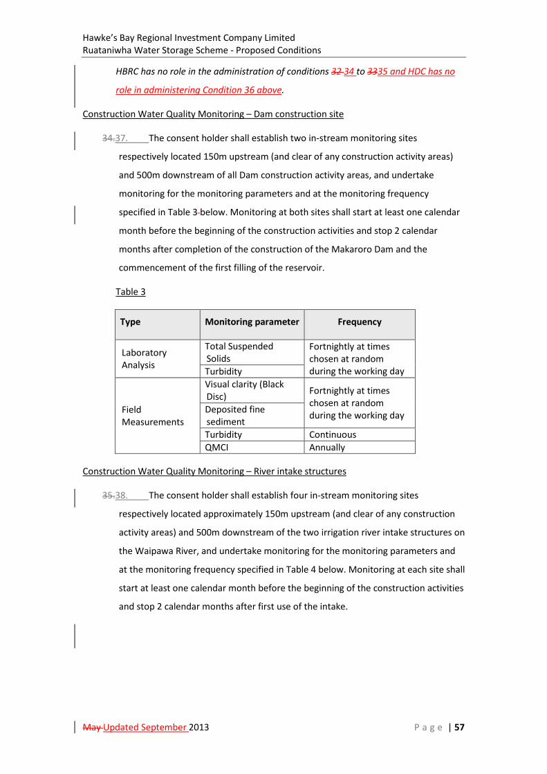
Hawke’s Bay Regional Investment Company Limited Ruataniwha Water Storage Scheme - Proposed Conditions
May Updated September 2013 P a g e | 57
HBRC has no role in the administration of conditions 32 34 to 3335 and HDC has no
role in administering Condition 36 above.
Construction Water Quality Monitoring – Dam construction site
34.37. The consent holder shall establish two in-stream monitoring sites
respectively located 150m upstream (and clear of any construction activity areas)
and 500m downstream of all Dam construction activity areas, and undertake
monitoring for the monitoring parameters and at the monitoring frequency
specified in Table 3 below. Monitoring at both sites shall start at least one calendar
month before the beginning of the construction activities and stop 2 calendar
months after completion of the construction of the Makaroro Dam and the
commencement of the first filling of the reservoir.
Table 3
Type Monitoring parameter Frequency
Laboratory Analysis
Total Suspended Solids
Fortnightly at times chosen at random during the working day Turbidity
Field Measurements
Visual clarity (Black Disc) Fortnightly at times
chosen at random during the working day Deposited fine
sediment Turbidity Continuous QMCI Annually
Construction Water Quality Monitoring – River intake structures
35.38. The consent holder shall establish four in-stream monitoring sites
respectively located approximately 150m upstream (and clear of any construction
activity areas) and 500m downstream of the two irrigation river intake structures on
the Waipawa River, and undertake monitoring for the monitoring parameters and
at the monitoring frequency specified in Table 4 below. Monitoring at each site shall
start at least one calendar month before the beginning of the construction activities
and stop 2 calendar months after first use of the intake.
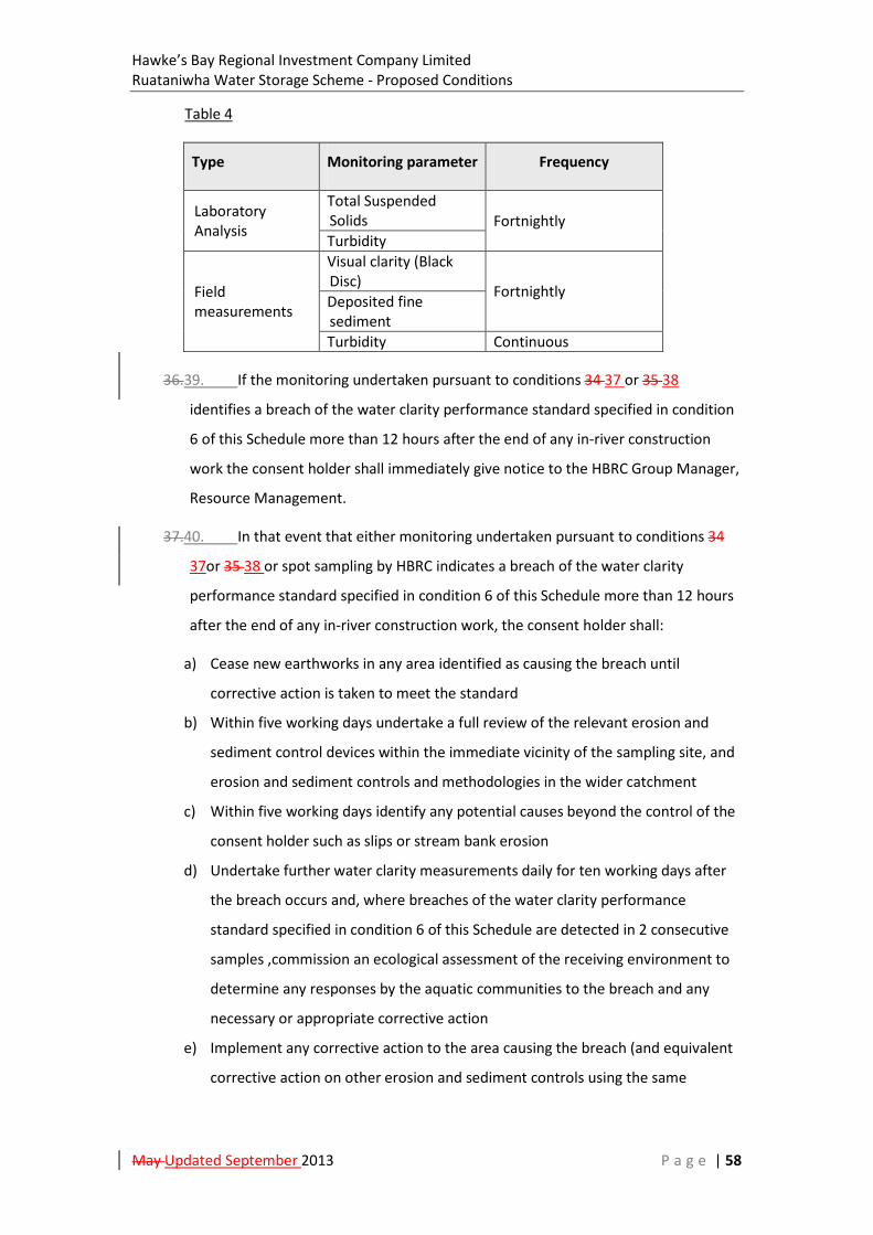
Hawke’s Bay Regional Investment Company Limited Ruataniwha Water Storage Scheme - Proposed Conditions
May Updated September 2013 P a g e | 58
Table 4
Type Monitoring parameter Frequency
Laboratory Analysis
Total Suspended Solids Fortnightly Turbidity
Field measurements
Visual clarity (Black Disc) Fortnightly Deposited fine sediment Turbidity Continuous
36.39. If the monitoring undertaken pursuant to conditions 34 37 or 35 38
identifies a breach of the water clarity performance standard specified in condition
6 of this Schedule more than 12 hours after the end of any in-river construction
work the consent holder shall immediately give notice to the HBRC Group Manager,
Resource Management.
37.40. In that event that either monitoring undertaken pursuant to conditions 34
37or 35 38 or spot sampling by HBRC indicates a breach of the water clarity
performance standard specified in condition 6 of this Schedule more than 12 hours
after the end of any in-river construction work, the consent holder shall:
a) Cease new earthworks in any area identified as causing the breach until
corrective action is taken to meet the standard
b) Within five working days undertake a full review of the relevant erosion and
sediment control devices within the immediate vicinity of the sampling site, and
erosion and sediment controls and methodologies in the wider catchment
c) Within five working days identify any potential causes beyond the control of the
consent holder such as slips or stream bank erosion
d) Undertake further water clarity measurements daily for ten working days after
the breach occurs and, where breaches of the water clarity performance
standard specified in condition 6 of this Schedule are detected in 2 consecutive
samples ,commission an ecological assessment of the receiving environment to
determine any responses by the aquatic communities to the breach and any
necessary or appropriate corrective action
e) Implement any corrective action to the area causing the breach (and equivalent
corrective action on other erosion and sediment controls using the same

Hawke’s Bay Regional Investment Company Limited Ruataniwha Water Storage Scheme - Proposed Conditions
May Updated September 2013 P a g e | 59
methodologies in the wider catchment) as recommended in the ecological
assessment
f) Identify action(s) necessary to ensure future compliance with the water quality
standards
g) Identify amendments to erosion and sediment control plan design,
methodologies and policies within the relevant catchment and, as appropriate,
as applicable elsewhere within the site, to ensure that a repeat breach does not
occur
h) Implement the actions identified in paragraph e), and the amendments
identified under paragraph f), above
i) Advise the HBRC Group Manager, Resource Management of the steps taken in
accordance with paragraphs b) to g) above
j) Incorporate the actions identified in paragraphs e) and f) within any revised
CEMP prepared under condition 8 of this Schedule.
38.41. The consent holder shall provide an annual report on the results of the
monitoring tasks outlined above in conditions 34 37 to 37 40 to the HBRC Group
Manager, Resource Management in a form compatible with the HBRC data systems.
Advisory Note:
HDC and CHBDC have no role in the administration of conditions 34 37 to 3841.
Cultural / Accidental Discovery Protocol
39.42. The consent holder shall ensure that the Cultural / Archaeological Sites
Protocol attached as Schedule Seven shall be adhered to.
Advisory note:
In addition to the above protocol, the consent holder is also subject to the legal
requirements of the Historic Places Act 1993, Antiquities Act 1975 and any other
governing legislation.
Construction Liaison Group (CLG)
40.43. The consent holder shall, prior to construction commencing and annually
thereafter during the construction period, advertise a public meeting for the
purpose of facilitating the establishment and review of a Construction Liaison
Group (CLG) in order to consult with representatives of the community. As a
Hawke’s Bay Regional Investment Company Limited Ruataniwha Water Storage Scheme - Proposed Conditions
May Updated September 2013 P a g e | 60
minimum, the consent holder shall invite the following interested parties to
participate in the CLG:
a) Tamatea Taiwhenua (1 nominated representative);
b) HBRC (1 nominated representative);
c) CHBDC (1 nominated representative);
d) HDC (1 nominated representative);
e) Landowners in the immediate vicinity of the reservoir footprint (2 nominated
representatives);
f) A representative from each of the five Irrigation Zones (Zones A to D and M)
chosen to provide an appropriate geographical spread and range of farming
systems;
f) Ruataniwha Plains Community (2 nominated representatives);
g) Department of Conservation (1 nominated representative);
h) Hawke’s Bay Fish and Game Council (1 nominated representative);and
i) Royal Forest and Bird Society (1 nominated representative).
41.44. The CLG shall be conducted in a manner of good faith and have the following
objectives:
a) Facilitating information flow between the consent holder and the community
regarding the implementation and environmental effects of the activities
authorised by these consents (including new information, results of monitoring
and studies relevant to such effects);
b) Identifying any issues of concern that arise during the construction period of the
Scheme and/or identifying and discussing appropriate measures to address
issues raised; and
c) Making recommendations for the consent holder to consider in relation to any
issues identified in terms of b) above.
42.45. The consent holder shall assist the CLG to fulfil its objectives by, among
other things:
a) Arranging an appropriate venue in the local area for the meetings of the CLG and
meeting any other reasonable administrative costs of the meetings;
b) Appointing a Community Liaison Officer with authority to represent it on the CLG
and ensuring the Community Liaison Officer attends all of the formal meetings of
the CLG;
Hawke’s Bay Regional Investment Company Limited Ruataniwha Water Storage Scheme - Proposed Conditions
May Updated September 2013 P a g e | 61
c) Ensuring that a representative of the Company responsible for construction the
Scheme under contract with the consent holder attends all meetings;
d) Providing information to the CLG about progress in relation to the Scheme,
including the environmental effects of the Scheme and compliance with consent
conditions and the development of management plans; and
e) Being prepared to discuss the environmental effects of the Scheme, any
concerns in relation to human health and safety, and any complaints from the
local community, including provision of further information and identification of
appropriate measures to address issues raised.
43.46. The consent holder shall use its best endeavours to ensure that meetings of
the CLG are held as follows:
a) At least once every three calendar months during the construction period
unless requested by the CLG that the meetings be more or less frequent; and
b) One meeting six calendar months prior to construction of Scheme commencing,
and one meeting six calendar months following completion of construction.
Review
44.47. The Consent Authorities may, during the March to June period within every
year that these consents (not including the Zones A to D Primary Distribution
System-Headrace Canal and Pipeline Designation) are current, serve notice on the
consent holder under section 128(1) of the Resource Management Act 1991, of
its/their intention to review the conditions of one of more of the consents they
have administrative responsibility for, for the following purposes:
a) To review the effectiveness of the conditions of the consents in avoiding,
remedying or mitigating any adverse effects on the environment from the
exercise of the consents and if necessary to avoid, remedy or mitigate such
effects by way of further or amended conditions;
b) To ensure that the conditions are consistent with any policies or rules in a
regional plan or National Environmental Standard or Regulation that becomes
legally effective after grant of consent; or
c) To review the adequacy of and the necessity for monitoring undertaken by the
consent holder.
Administration

Hawke’s Bay Regional Investment Company Limited Ruataniwha Water Storage Scheme - Proposed Conditions
May Updated September 2013 P a g e | 62
45.48. The Consent Holder shall pay to the Consent Authorities any administrative
charge fixed in accordance with section 36 of the Resource Management Act 1991,
or any charge prescribed in accordance with regulations made under section 360 of
the Resource Management Act 1991.
Hawke’s Bay Regional Investment Company Limited Ruataniwha Water Storage Scheme - Proposed Conditions
May Updated September 2013 P a g e | 63
SCHEDULE TWO
GENERAL CONDITIONS – OPERATIONS AND MAINTENANCE

Hawke’s Bay Regional Investment Company Limited Ruataniwha Water Storage Scheme - Proposed Conditions
May Updated September 2013 P a g e | 64
Schedule Two General Conditions – Operations & Maintenance
General Conditions attached to the CHBDC Land Use Consent, HDC Land Use Consent,
HBRC Resource Consents LU120370C, WP120371M, LU120372C, WP120373T, LU120374C,
WP120375T, LU120376C, LU120377C, LU120378C, DP120379W, LU120380C, DP120381W
and the Primary Distribution System designation within Central Hawke’s Bay District
collectively covering operations and maintenance (including mitigation and offset works
commencing with construction) of the Ruataniwha Water Storage Scheme (the “Scheme”)
Advisory Notes:
i. These conditions relate to land use consents falling within the administrative
jurisdiction of CHBDC and HDC, a designation falling within the administrative
jurisdiction of CHBDC and to a number of resource consents falling within the
administrative jurisdiction of HBRC.
ii. The conditions in this Schedule are administered by all three Councils except to the
extent recorded in the advisory notes to these conditions.
iii. Reference to “consents” in these conditions includes the resource consents
referenced in the heading above and the Zones A to D Primary Distribution System
designation.
[Note: The intention is to split out the relevant conditions in this schedule into a standalone
set of Primary Distribution System designation conditions once the final content of the
conditions has been confirmed after the release of a Draft Board of Inquiry Decision]
Integrated Mitigation and Offset Programme
1. Upon commencing construction, the consent holder shall also commence the
funding and implementation of the programme specified within the Integrated
Mitigation and Offset Approach Report submitted with the application – HBRIC (May
2013f), including but not limited to the establishment of a Ruataniwha Biodiversity
Advisory Board, in order to meet the performance targets in section 3.0 of that
report related to the following projects:
a) Ruataniwha Reservoir Restoration Buffer and Catchment Enhancement Zone;
b) Ruataniwha Riparian Enhancement Zone (River Halo Project);
c) Ruataniwha Threatened Species Enhancement;
d) Ruataniwha Plains Spring-fed Stream Enhancement and Priority Sub-catchment
Phosphorus Mitigation; and

Hawke’s Bay Regional Investment Company Limited Ruataniwha Water Storage Scheme - Proposed Conditions
May Updated September 2013 P a g e | 65
e) Old Waipawa River Bed and Papanui Stream Restoration.
The consent holder shall secure all necessary third party land agreements to
implement Project A are in place prior to completion of the dam. The consent
holder shall supply the Consent Authorities with a statement confirming the legal
property arrangements which secure the land areas required to implement the
proposed delivery mechanisms and performance measures for Project A as outlined
in the Integrated Mitigation and Offset Approach Report submitted with the
application – HBRIC (May 2013f).
2. Each year in the month of July following the commencement of construction the
consent holder shall convene an Annual Review Meeting to report on progress on
the Integrated Mitigation and Offset Approach Programme. Members of the
Ruataniwha Biodiversity Advisory Board, the HBRC Regional Planning Committee (or
equivalent regional planning governance entity) and relevant contractors shall be
invited to the Annual Review Meeting which shall have the following objectives:
a) To review an Integrated Mitigation and Offset Programme Annual Report
prepared by the Consent Holder which is to be pre-circulated at least a calendar
month prior to the Annual Review Meeting which sets out:
i. The specific work undertaken in the preceding year on each of the
projects outlined in condition 1 of this Schedule;
ii. The amount spent on each project over that period reported against the
budgets contained in the Integrated Mitigation and Offset Approach
Report submitted with the application – HBRIC (May 2013f);
iii. An assessment of whether the Performance Targets set out in the
Integrated Mitigation and Offset Approach Report submitted with the
application – HBRIC (May 2013f) are being met; and
iv. Any recommendations for altering the focus of any of the Integrated
Mitigation and Offset Approach projects which it is considered would
better meet the objectives of the programme within the budgets set in
the Integrated Mitigation and Offset Approach Report submitted with
the application – HBRIC (May 2013f).
b) To develop and agree an Annual Meeting Report for distribution to the Consent
Authorities within one calendar month after the meeting is held outlining the
outcomes of meeting, including any agreement with recommendations made
under condition 2 a) iv of this schedule.

Hawke’s Bay Regional Investment Company Limited Ruataniwha Water Storage Scheme - Proposed Conditions
May Updated September 2013 P a g e | 66
3. Upon receipt of the Integrated Mitigation and Offset Programme Annual Report
prepared by the Consent Holder and the Annual Meeting Report the Consent
Authorities may approve (in a certifier capacity) a variation to the programme
specified within the Integrated Mitigation and Offset Approach Report, provided
that the ability to meet the Performance Targets and the overall budget provision
for each project set out in condition 1 of this schedule are not reduced.
Infrastructure Stormwater and Maintenance Management Plan
4. Prior to the completion of dam construction , the consent holder shall provide to the
Consent Authorities an Infrastructure Stormwater and Maintenance Management
Plan (ISMMP) to cover the effective management of stormwater, including
containment of oil and the maintenance of structures authorised by these consents
and which shall be prepared by a suitably qualified and experienced person(s).
Objective for the ISMMP
The objective of the ISMMP is to ensure that stormwater management and
maintenance works necessary to enable efficient operation of the structures
authorised by these consents are undertaken in a manner which identifies roles and
responsibilities for and integrates good environmental practice into stormwater
management and maintenance activities.
ISMMP Performance Standards
a) Erosion and sediment controls shall be installed and maintained on all soil
disturbance activities during maintenance works in accordance with the HBRC
Waterway Guidelines for Erosion and Sediment Control;
b) All potentially erodible exposed soil areas capable of generating sediment shall
be stabilised against erosion by vegetation cover or other methods as soon as
practical following completion of soil disturbing activities and within six to
twelve months from the date of disturbance or the next planting season
(whichever is sooner) to avoid adverse effects of sediment discharge to water;
c) All ‘clean water’ runoff from stabilised surfaces shall be diverted away from
earthwork areas via a stabilised system to prevent surface erosion;

Hawke’s Bay Regional Investment Company Limited Ruataniwha Water Storage Scheme - Proposed Conditions
May Updated September 2013 P a g e | 67
d) The percentage reduction to the Quantitative Macroinvertebrate Community
Index (QMCI) score relative to the QMCI up stream of the discharge shall not
exceed 20% after reasonable mixing4 at all flows;
e) The percentage reduction in water clarity resulting from any discharge of
stormwater from Scheme Structures and during maintenance activities relative
to water up stream of the discharge should not exceed the following;
i. 20% at flows less than the median flow after reasonable mixing for
works in Water Management Zone 4 and works on the main stems of the
Tukituki River or the Waipawa River in zones 1, 2 and 3 (refer to HBRC
Plan Change 6, Planning Map - Water Management Zones as notified in
May 2013);
ii. 30% at flows less than the median flow after reasonable mixing for
works elsewhere.
f) The following performance standards shall apply to the management of facilities
containing oil:
i. All bunded stormwater shall be discharged through an oil and water
separator device(s) prior to final discharge.
ii. The oil separator control systems shall be maintained and operated
according to the manufacturer’s directions so that at all times it is
operating within its design criteria. Solid waste collected in the
stormwater system shall be removed and disposed of at an approved
landfill. Details of inspections and maintenance shall be recorded and
provided to the Council on request.
iii. All transformers and oil bearing equipment containing at least 1,500
litres oil shall be located on concrete bunded pads. Each pad shall have
the capacity to hold at least the discharge from the single piece of
equipment containing the largest volume of oil and a one in ten year ARI
rainfall event of at least 22.5 mm over 30 minutes (taken from Hawke’s
4 For purpose of these conditions “reasonable mixing” of contaminants in flowing surface water will be considered to have occurred at whichever of the following is the nearest to the point of discharge:
a) a distance 200 metres downstream of the point of discharge;
b) a distance equal to seven times the bed width of the surface water body, but which shall be not less than 50 metres;
c) the distance downstream at which mixing of contaminants has occurred across the full width of the surface water body, but which shall not be less than 50 metres.
Hawke’s Bay Regional Investment Company Limited Ruataniwha Water Storage Scheme - Proposed Conditions
May Updated September 2013 P a g e | 68
Bay Waterway Guidelines Stormwater Management, HBRC Plan Number
4104, Shaver, E. & Clode, G. May 2009, page 59).
iv. The concentration of the oil (total) in the discharge shall not exceed 15
milligrams/litre.
v. The consent holder shall ensure that there is a point where the
stormwater discharged from oil separator control systems can be
sampled at or prior to the point of discharge. The consent holder shall
provide access to this sampling point for the Council to enable a sample
to be taken during an inspection. The cost of any sample taken will be
charged to the consent holder.
vi. An electronic warning system on the transformers shall trigger an alarm
alerting staff of fault or malfunction. Alarms shall be monitored by staff
at all times and acted upon within 60 minutes. A system failure shall be
rectified within five working days.
vii. A log shall be kept of all oil spill control system alarms stating the date,
time, problem and any remedial action taken. This log shall be made
available to the Council for inspection at any time.
viii. That where, for any cause (accidental or otherwise), contaminants
associated with the consent holder’s operations escape to water other
than in conformity with the consent, the consent holder shall:
Immediately take all practicable steps to contain and then remove the contamination from the environment, and;
Immediately notify the Council of the escape, and;
Report to the Council, in writing and within 7 days, describing the manner and cause of the escape and steps taken to control it and prevent its reoccurrence.
5. The Consent Holder may commence maintenance activities in accordance with the
ISMMP unless one or more of the Consent Authorities advises the consent holder in
writing within 20 working days of receipt of the ISMMP that it refuses to certify the
ISMMP on the grounds that it fails to meet the requirements of condition 4 above in
relation to an activity within the relevant Consent Authorities jurisdiction, and
provides reasons why that view is held.
6. Should the Consent Authorities refuse to certify the ISMMP in accordance with
condition 3 above, the consent holder shall submit a revised ISMMP to the Consent
Hawke’s Bay Regional Investment Company Limited Ruataniwha Water Storage Scheme - Proposed Conditions
May Updated September 2013 P a g e | 69
Authorities for certification as soon as is practicable. The certification process shall
follow the same procedure as outlined in condition 4 and 5 above.
7. Once certified the ISMMP may be varied by the consent holder. The certification
process for an ISMMP Variation shall follow the process outlined in conditions 2 to 4
above. Maintenance activities subject to the variation shall not commence until the
variation has been certified by the Consent Authorities.
8. The consent holder shall comply with the certified IMMP at all times.
Advisory Note:
HDC has no role in the administration of conditions 4 to 8.
Sediment Management Plan
9. The consent holder shall no less than 20 working days prior to the first filling of the
reservoir engage a suitably qualified and experienced Engineer to prepare a
Sediment Management Plan (SMP) in conjunction for certification by the HBRC
Group Manager- Resource Management that the plan implements conditions 2 to 5
of Resource Consent LU120370C and the recommendations contained in the
Sedimentation Assessment Report filed with the applications - Tonkin & Taylor (May
2013b).
10. The Consent Holder may not commission the Makaroro Dam unless the HBRC Group
Manager- Resource Management certifies that the SMP meets the requirements of
condition 9 above.
11. Should the HBRC Group Manager, Resource Management refuse to certify the SMP
in accordance with condition 10 above, the consent holder shall submit a revised
SMP for certification as soon as is practicable. The certification process shall follow
the same procedure as outlined in condition 9 and 10 above.
12. Once certified the SMP may be varied by the consent holder. The certification
process for a SMP Variation shall follow the process outlined in conditions 9 to 11
above.
13. The consent holder shall comply with the certified SMP at all times.
Advisory Note:
HDC and CHBDC have no role in the administration of conditions 9 to 13.

Hawke’s Bay Regional Investment Company Limited Ruataniwha Water Storage Scheme - Proposed Conditions
May Updated September 2013 P a g e | 70
Reservoir Inflows, Water Level and Flow Releases
14. The consent holder shall estimate inflows into and measure the water level of the
reservoir immediately behind the Makaroro Dam and all flow releases from the dam,
other than spillway flows. A record shall be kept of all estimates and measurements
pursuant to this condition and made available to the HBRC Group Manager,
Resource Management upon request.
Water Take and Water Discharges
15. The consent holder shall measure and record the volume and rate of water taken
from the Waipawa River (Upstream Water Intake and subsequent Primary Headrace
canal takes, and Downstream Water Intake) and the volume and rate of water
discharged into the Mangaonuku Stream and the Kahahakuri Stream.
16. The location of the flow measuring device or system shall be as close as practicable
to the site of take or discharge as certified by HBRC Group Manager Resource
Management as providing a true record of water flows.
Measurement Accuracy and Reporting
17. All measurements shall be taken at the following levels of accuracy:
a) Open channel measurements shall be measured with an accuracy of +/- 10%;
b) Closed pipe measurements shall be measured with an accuracy of +/- 5%; and
c) Water level measurements shall be measured with an accuracy of +/- 1mm.
18. Each water level, rate, or volume measurement site shall be equipped with a data
logger and telemetry unit. Data loggers and telemetry units shall record the water
level, rate or volume of take every 15 minutes. Each 15 minute interval of data shall
be date and time stamped with the New Zealand Standard Time at the end of the 15
minute interval. Data shall be transmitted to the Council’s telemetry system at least
once per day.
Verification of Flow Measurement and Level Equipment Accuracy
19. The consent holder shall engage a person who, in the opinion of the HBRC Group
Manager, Resource Management, is suitably qualified to verify the accuracy of the
flow measuring device or system. Verification of accuracy shall be undertaken at the
following frequencies:

Hawke’s Bay Regional Investment Company Limited Ruataniwha Water Storage Scheme - Proposed Conditions
May Updated September 2013 P a g e | 71
a) For closed pipe measuring devices, verification shall occur before the end of the
first year of water take / discharge and at five yearly intervals thereafter;
b) For open channel measuring devices, verification shall occur three monthly.
Maintenance of Flow Measurement and Level Equipment
20. The consent holder shall ensure the functionality and accuracy of the equipment
measuring, recording and reporting on reservoir water levels, flow releases from the
dam, takes from the Waipawa River and discharges of water into the Mangaonuku
and Kahahakuri Streams. Any failed measuring device shall be reinstated within
seven days, to the standards required above.
Advisory Note:
HDC and CHBDC have no role in the administration of conditions 14 to 20.
Dam Safety Requirements
21. The consent holder shall ensure that the Makaroro Dam and all its associated
components and accessory structures are designed, constructed and maintained to
operate in a safe and stable condition. Without loss of generality, the Makaroro Dam
shall be designed such that the maximum design flood level for the reservoir formed
upstream of the Makaroro Dam shall not exceed a level 30 centimetres below the
effective crest of the Dam (based on a 3 hour rolling average), as measured at the
Makaroro Dam.
22. Dam safety shall be managed in accordance with the principles of the Dam Safety
Guidelines issued by the New Zealand Society on Large Dams and the requirements
of the Building Act 2004.
23. The consent holder shall engage a Professional Engineer with experience in design
and construction of large dams in seismically active areas to certify that the design
of the dam and its construction are in accordance with good engineering practice
including being consistent with the Dam Safety Guidelines issued by the New
Zealand Society on Large Dams and the requirements of the Building Act 2004. This
certificate shall be submitted to the HBRC Group Manager, Resource Management
prior to first filling of the dam reservoir.
24. Prior to the first filling of the dam reservoir, a Dam Safety Assurance Programme
shall be produced by a Category A recognised engineer, as defined by the Building
(Dam Safety) Regulations 2008, outlining a programme of inspections and quality
Hawke’s Bay Regional Investment Company Limited Ruataniwha Water Storage Scheme - Proposed Conditions
May Updated September 2013 P a g e | 72
assurance for the dam and its associated components and accessory structures. The
Dam Safety Assurance Programme shall be developed to be consistent with the Dam
Safety Guidelines issued by the New Zealand Society on Large Dams and shall be
certified as appropriate by the recognised engineer and both the Programme and
covering certificate shall be submitted to the HBRC Group Manager, Resource
Management prior to first filling of the dam reservoir. The Dam Safety Assurance
Programme shall as a minimum:
a) Be consistent with the Dam Safety Guidelines issued by the New Zealand
Society on Large Dams and the requirements of the Building Act 2004 and
the Building (Dam Safety) Regulations 2008;
b) Address the distinct requirements of both the reservoir first filling stage and
the scheme operational stage;
c) Include a monitoring system capable of reliably and accurately detecting
warning signs of threats to dam safety;
d) Specify an organisational approach that efficiently records processes,
evaluates and reports observations of the dam’s performance;
e) Include trigger levels for observational results that are considered to require
action;
f) Include a strategy of mitigation and actions to be undertaken in the event
the specified trigger levels are exceeded;
g) Provide for reporting to the HBRC Group Manager, Resource Management
of any trigger level exceedence and actions taken to address any such
exceedence;
h) Provide for inspection of the dam and its associated components and
accessory structures as soon as practicable after any earthquake with an
intensity of IX or greater on the Modified Mercalli scale is experienced at the
dam; and
i) Provide for reporting to the HBRC Group Manager Resource Manager of the
results of any inspection undertaken in accordance with (h) above.
25. The consent holder shall comply with the Dam Safety Assurance programme at all
times.
Advisory Note:
HDC and CHBDC have no role in the administration of conditions 21 to 25.
Hawke’s Bay Regional Investment Company Limited Ruataniwha Water Storage Scheme - Proposed Conditions
May Updated September 2013 P a g e | 73
Emergency Action Plan
26. The consent holder shall engage a professional engineer with experience in
management of large dams with an assessed Potential Impact Category of High to
prepare an Emergency Action Plan (EMP) to ensure appropriate management of the
risk associated with uncontrolled abnormal or excessive flow releases from the Dam.
The Emergency Action Plan shall be prepared in consultation with the Civil Defence
Emergency Management Group and shall, as far as practicable, be consistent with
the Civil Emergency Management Group Plan governing the Central Hawke’s Bay
District pursuant to the Civil Defence Emergency Management Act 2002. It shall
contain, as a minimum:
a) Maps of land areas modelled as being subject to inundation in the event of
abnormal or excessive flow releases and contact details for people resident
within those areas, where they can be ascertained; and
b) Contingency plans for alerting people within the identified areas of
inundation and relevant civil defence authorities of the risk of such events.
A copy of the Emergency Action Plan shall be provided to HBRC, CHBDC, HDC, the
Civil Defence Emergency Management Group and the New Zealand Transport
Agency prior to reservoir filling.
27. The consent holder shall cause the EMP to be periodically reviewed, timed to
coincide with a review of the Civil Emergency Management Group Plan governing
the Central Hawke’s Bay District pursuant to the Civil Defence Emergency
Management Act 2002. Such reviews shall follow the same process as for the initial
EMP.
Water Level Safety Plan
28. The consent holder shall, in consultation with the Central Hawke’s Bay District
Council, prepare and submit to the Hawke’s Bay Regional Council Group Manager,
Resource Management for approval a Water Level Safety Plan (WLSP) within 6
calendar months of the commencement of this consent.
29. The WLSP is to detail procedures (signage, warning sirens, and public information) to
warn of the risk to public safety of planned sudden operational changes in river
flows along the Makaroro River below the Makaroro Dam at points accessible to the
public.
Hawke’s Bay Regional Investment Company Limited Ruataniwha Water Storage Scheme - Proposed Conditions
May Updated September 2013 P a g e | 74
30. The signage plan shall identify the sites and the form and content of the signs,
warning sirens and public information procedures to be used by the consent holder.
31. The consent holder shall provide, maintain, and operate signage and warning sirens
in good repair in accordance with the plan.
Advisory Note:
HDC has no role in the administration of conditions 28 to 31.
Review
32. The Consent Authorities may, during the March to June period within every year
that these consents are current, serve notice on the consent holder under section
128(1) of the Resource Management Act 1991, of its/their intention to review the
conditions of one of more of the consents they have administrative responsibility
for, for the following purposes:
a) To review the effectiveness of the conditions of the consents in avoiding,
remedying or mitigating any adverse effects on the environment from the
exercise of the consents and if necessary to avoid, remedy or mitigate such
effects by way of further or amended conditions;
b) To ensure that the conditions are consistent with any policies or rules in a
regional plan or National Environmental Standard or Regulation that
becomes legally effective after grant of consent; or
c) To review the adequacy of and the necessity for monitoring undertaken by
the consent holder.
Hawke’s Bay Regional Investment Company Limited Ruataniwha Water Storage Scheme - Proposed Conditions
May Updated September 2013 P a g e | 75
SCHEDULE THREE
GENERAL CONDITIONS – USE OF WATER FOR PRODUCTION LAND USE
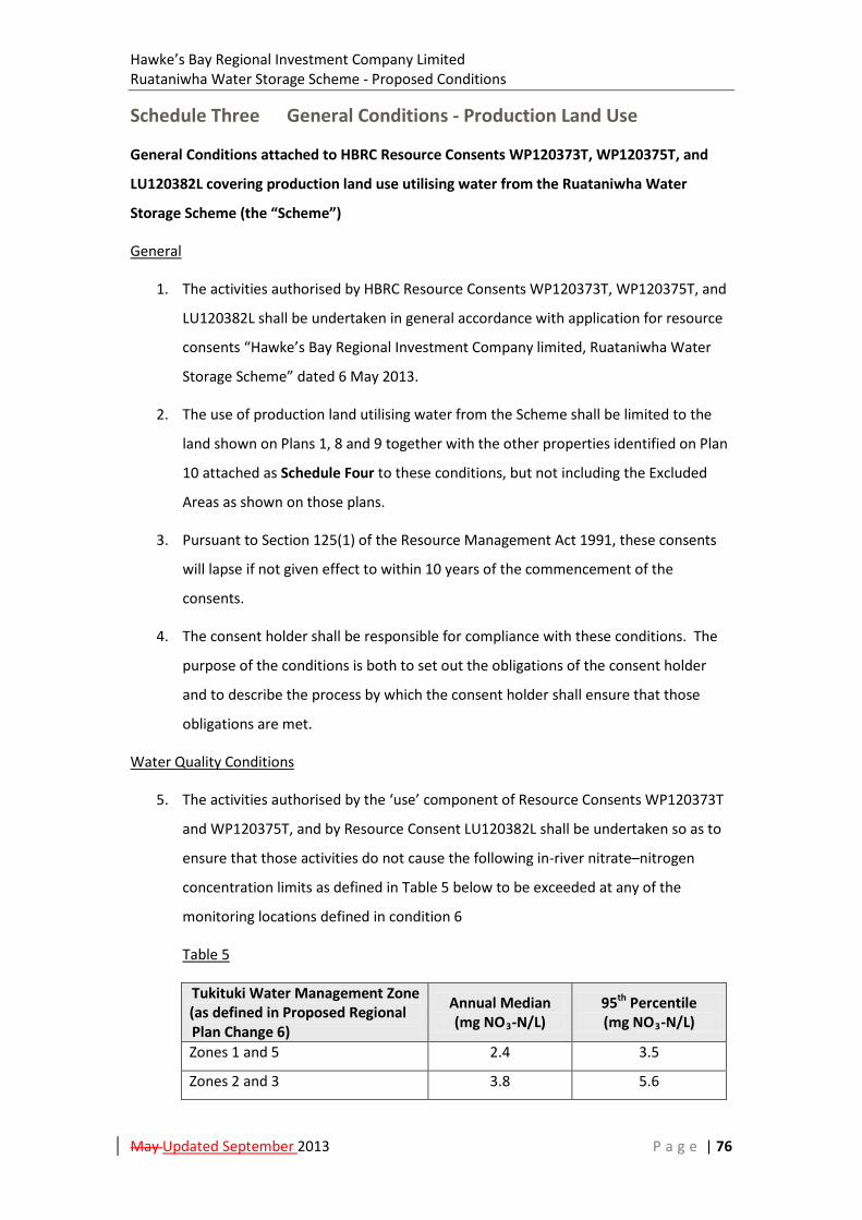
Hawke’s Bay Regional Investment Company Limited Ruataniwha Water Storage Scheme - Proposed Conditions
May Updated September 2013 P a g e | 76
Schedule Three General Conditions - Production Land Use
General Conditions attached to HBRC Resource Consents WP120373T, WP120375T, and
LU120382L covering production land use utilising water from the Ruataniwha Water
Storage Scheme (the “Scheme”)
General
1. The activities authorised by HBRC Resource Consents WP120373T, WP120375T, and
LU120382L shall be undertaken in general accordance with application for resource
consents “Hawke’s Bay Regional Investment Company limited, Ruataniwha Water
Storage Scheme” dated 6 May 2013.
2. The use of production land utilising water from the Scheme shall be limited to the
land shown on Plans 1, 8 and 9 together with the other properties identified on Plan
10 attached as Schedule Four to these conditions, but not including the Excluded
Areas as shown on those plans.
3. Pursuant to Section 125(1) of the Resource Management Act 1991, these consents
will lapse if not given effect to within 10 years of the commencement of the
consents.
4. The consent holder shall be responsible for compliance with these conditions. The
purpose of the conditions is both to set out the obligations of the consent holder
and to describe the process by which the consent holder shall ensure that those
obligations are met.
Water Quality Conditions
5. The activities authorised by the ‘use’ component of Resource Consents WP120373T
and WP120375T, and by Resource Consent LU120382L shall be undertaken so as to
ensure that those activities do not cause the following in-river nitrate–nitrogen
concentration limits as defined in Table 5 below to be exceeded at any of the
monitoring locations defined in condition 6
Table 5
Tukituki Water Management Zone (as defined in Proposed Regional Plan Change 6)
Annual Median (mg NO3-N/L)
95th Percentile (mg NO3-N/L)
Zones 1 and 5 2.4 3.5
Zones 2 and 3 3.8 5.6
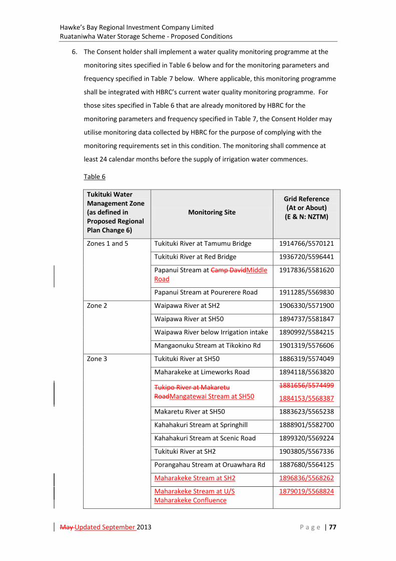
Hawke’s Bay Regional Investment Company Limited Ruataniwha Water Storage Scheme - Proposed Conditions
May Updated September 2013 P a g e | 77
6. The Consent holder shall implement a water quality monitoring programme at the
monitoring sites specified in Table 6 below and for the monitoring parameters and
frequency specified in Table 7 below. Where applicable, this monitoring programme
shall be integrated with HBRC’s current water quality monitoring programme. For
those sites specified in Table 6 that are already monitored by HBRC for the
monitoring parameters and frequency specified in Table 7, the Consent Holder may
utilise monitoring data collected by HBRC for the purpose of complying with the
monitoring requirements set in this condition. The monitoring shall commence at
least 24 calendar months before the supply of irrigation water commences.
Table 6
Tukituki Water Management Zone (as defined in Proposed Regional Plan Change 6)
Monitoring Site
Grid Reference (At or About)
(E & N: NZTM)
Zones 1 and 5 Tukituki River at Tamumu Bridge 1914766/5570121
Tukituki River at Red Bridge 1936720/5596441
Papanui Stream at Camp DavidMiddle Road
1917836/5581620
Papanui Stream at Pourerere Road 1911285/5569830
Zone 2 Waipawa River at SH2 1906330/5571900
Waipawa River at SH50 1894737/5581847
Waipawa River below Irrigation intake 1890992/5584215
Mangaonuku Stream at Tikokino Rd 1901319/5576606
Zone 3 Tukituki River at SH50 1886319/5574049
Maharakeke at Limeworks Road 1894118/5563820
Tukipo River at Makaretu RoadMangatewai Stream at SH50
1881656/5574499
1884153/5568387
Makaretu River at SH50 1883623/5565238
Kahahakuri Stream at Springhill 1888901/5582700
Kahahakuri Stream at Scenic Road 1899320/5569224
Tukituki River at SH2 1903805/5567336
Porangahau Stream at Oruawhara Rd 1887680/5564125
Maharakeke Stream at SH2 1896836/5568262
Maharakeke Stream at U/S Maharakeke Confluence
1879019/5568824

Hawke’s Bay Regional Investment Company Limited Ruataniwha Water Storage Scheme - Proposed Conditions
May Updated September 2013 P a g e | 78
Tukipo River at U/S Makaretu Confluence
1897330/5569186
Tukipo River at SH50 1884777/5570703
Advisory Notes:
i. A suitable location for the Papanui Stream at Middle Road monitoring site is
being investigated and it is possible that a location located downstream of
Camp David will be selected.
i.ii. High flow conditions can prevent safe access to the Makaretu at U/S
Maharakeke Monitoring site. Under such conditions, sampling shall be
undertaken at the following location: Makaretu River at Speedy Road
(1894421/5567602 – NZTM).
Table 7
Type Monitoring parameter Frequency
Laboratory Analysis
Nitrate Nitrogen Monthly
Total Ammoniacal Nitrogen
Total Nitrogen
Dissolved Organic Nitrogen
Turbidity
DRP
Total Phosphorus
Dissolved Organic Phosphorous
E.Coli (CFU)
MCI Annual
Periphyton biomass
Field Measurements Horizontal visibility (black disc) Monthly
pH
Conductivity
Temperature
Periphyton cover, including the presence and relative abundance of Phormidium Spp (Visual)
Deposited sediment cover (visual)
7. At any locations where in-stream annual median and/or 95 percentile nitrate–
nitrogen concentrations measured by the consent holder or HBRC are greater than

Hawke’s Bay Regional Investment Company Limited Ruataniwha Water Storage Scheme - Proposed Conditions
May Updated September 2013 P a g e | 79
80% of the limits set out in condition 5 above, the consent holder shall assess
whether the operation of property owners contracted to use water from the
Scheme (“Scheme Participants”) needs to be adapted to ensure compliance with
condition 5 as follows:
a) The nitrogen outputs for the actual land use by Scheme participants in that
part of the catchment above the sampling point shall be compared to the
Current Land Use Scenario and the Post Irrigation Land Use Scenario as at 6
May 2013 as presented with the resource consent applications for the
Scheme in the TRIM2 Stream Modelling Reports submitted with the
applications - NIWA (May 2013a) and NIWA (May 2013b)
b) The nitrogen outputs for the actual land use by Scheme participants in that
part of the surface and groundwater catchment above the sampling point
shall be modelled to predict the in-stream nitrate-nitrogen concentration at
the sampling point.
c) The modelling will use the NIWA TRIM2 model used as detailed in NIWA
(May 2013a) and NIWA (May 2013b) supplied with the Applications or an
updated version of that model or an alternative model certified as being fit
for purpose by the HBRC Group Manager, Resource Management.
8. In the event that modelling undertaken for the purposes of condition 7 above
predicts that the continued use of production land utilising water from the Scheme
is likely to cause measured nitrate-nitrogen concentrations to exceed the limits in
condition 5 then the consent holder shall:
a) Require all landowners receiving waters from the Scheme potentially affecting
the in- stream concentrations measured as exceeding 80% of the limits in
condition 5 to immediately review their respective Farm Environmental
Management Plans to identify and implement additional on-farm nitrogen
leaching mitigation measures sufficient to reduce modelled outputs to the
extent necessary to ensure the combined nitrogen outputs from farming
operations supplied with water from the Scheme do not cause in-stream nitrate-
nitrogen concentrations to exceed the limits in condition 5.
b) Re-run the model of production use activities to demonstrate the effect of the
steps taken in terms of in-stream nitrate-nitrogen concentrations.
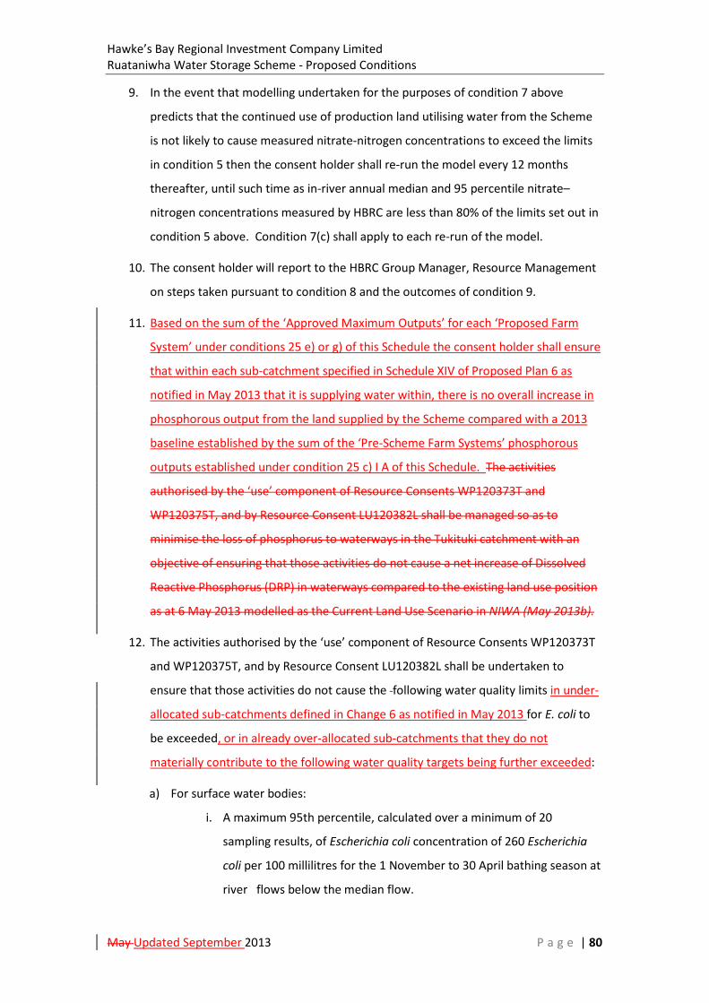
Hawke’s Bay Regional Investment Company Limited Ruataniwha Water Storage Scheme - Proposed Conditions
May Updated September 2013 P a g e | 80
9. In the event that modelling undertaken for the purposes of condition 7 above
predicts that the continued use of production land utilising water from the Scheme
is not likely to cause measured nitrate-nitrogen concentrations to exceed the limits
in condition 5 then the consent holder shall re-run the model every 12 months
thereafter, until such time as in-river annual median and 95 percentile nitrate–
nitrogen concentrations measured by HBRC are less than 80% of the limits set out in
condition 5 above. Condition 7(c) shall apply to each re-run of the model.
10. The consent holder will report to the HBRC Group Manager, Resource Management
on steps taken pursuant to condition 8 and the outcomes of condition 9.
11. Based on the sum of the ‘Approved Maximum Outputs’ for each ‘Proposed Farm
System’ under conditions 25 e) or g) of this Schedule the consent holder shall ensure
that within each sub-catchment specified in Schedule XIV of Proposed Plan 6 as
notified in May 2013 that it is supplying water within, there is no overall increase in
phosphorous output from the land supplied by the Scheme compared with a 2013
baseline established by the sum of the ‘Pre-Scheme Farm Systems’ phosphorous
outputs established under condition 25 c) I A of this Schedule. The activities
authorised by the ‘use’ component of Resource Consents WP120373T and
WP120375T, and by Resource Consent LU120382L shall be managed so as to
minimise the loss of phosphorus to waterways in the Tukituki catchment with an
objective of ensuring that those activities do not cause a net increase of Dissolved
Reactive Phosphorus (DRP) in waterways compared to the existing land use position
as at 6 May 2013 modelled as the Current Land Use Scenario in NIWA (May 2013b).
12. The activities authorised by the ‘use’ component of Resource Consents WP120373T
and WP120375T, and by Resource Consent LU120382L shall be undertaken to
ensure that those activities do not cause the following water quality limits in under-
allocated sub-catchments defined in Change 6 as notified in May 2013 for E. coli to
be exceeded, or in already over-allocated sub-catchments that they do not
materially contribute to the following water quality targets being further exceeded:
a) For surface water bodies:
i. A maximum 95th percentile, calculated over a minimum of 20
sampling results, of Escherichia coli concentration of 260 Escherichia
coli per 100 millilitres for the 1 November to 30 April bathing season at
river flows below the median flow.
Hawke’s Bay Regional Investment Company Limited Ruataniwha Water Storage Scheme - Proposed Conditions
May Updated September 2013 P a g e | 81
ii. A maximum 95th percentile, calculated over a minimum of 20
sampling results, of Escherichia coli concentration of 550 Escherichia
coli per 100 millilitres for the 1 November to 30 April bathing season at
river flows between the median flow and three times the median flow.
iii. A maximum 95th percentile, calculated over a minimum of 20
sampling results, of Escherichia coli concentration of 550 Escherichia
coli per 100 millilitres for the rest of the year at river flows below three
times the median flow.
b) For groundwater less than one Escherichia coli per 100 millilitres
13. Each year in the month of June, the consent holder shall undertake an assessment of
the monitoring results obtained under condition 6 of this Schedule against the water
quality limits and targets set in condition 12 above. In the event that monitoring
undertaken pursuant to condition 6 above identifies that the limits or targets set in
condition 12 are being exceeded at any of the monitoring sites specified in condition
6, the consent holder shall:
a) Undertake further monitoring to confirm or otherwise the exceedences; and
b) Undertake an assessment of the likely causes and sources of the exceedences.
This assessment shall be completed and reported to the HBRC Group Manager,
Resource Management by the 30th June in the following year.
14. In the event that the assessment undertaken pursuant to condition 13 above
identifies that the activities authorised by the ‘use’ component of Resource
Consents WP120373T and/or WP120375T, and/or by Resource Consent LU120382L
are the cause of, or a significant contributor to, the exceedences, the consent holder
shall identify specific actions required to be taken by property land owners supplied
by the Scheme upstream from the monitoring site(s) where the exceedences have
been measured in order to ensure that the land ‘use’ component of Resource
Consents WP120373T and or WP120375T does not cause, or be a material
contributor to, the exceedences the limits specified in condition 12 are met and shall
procure that the required steps are taken as soon as practicable thereafter.
15. Prior to the exercise of Resource Consents WP120373T, WP120375T, and
LU120382L, the consent holder shall engage a suitable professionally qualified and
experienced person to prepare a Groundwater Monitoring Plan (GMP), in
Hawke’s Bay Regional Investment Company Limited Ruataniwha Water Storage Scheme - Proposed Conditions
May Updated September 2013 P a g e | 82
consultation with the Hawke’s Bay District Health Board and the HBRC Group
Manager, Resource Management. The Plan shall address the following matters:
a) Identification on a best endeavours basis of the location of and water quality in
existing bores utilised for the supply of human drinking water within the area
serviced by the Scheme, prior to the exercise of these consents;
b) A plan for the ongoing monitoring of groundwater trends influenced by the
exercise of these consents in order to identify changes in groundwater quality in
waters used for the supply of human drinking water; and
c) A plan to assess the risk to groundwater quality of existing bores utilised for the
supply of human drinking water based on the monitoring results obtained under
condition 15 b) above and taking into account groundwater catchments and
groundwater age and transport times.
16. Should the monitoring results obtained under condition 15 b) exceed 80% of the
nitrate concentration standard in the Drinking-Water Standards for New Zealand
2005 (2008 or subsequent revision), or the risk assessment undertaken under
condition 15 c) indicate there is potential for the nitrate concentration standard in
the Drinking-Water Standards for New Zealand 2005 (2008 or subsequent revision)
to be exceeded, the consent holder shall identify specific actions required to be
taken by property owners supplied by the Scheme upstream from bores utilised for
the supply of human drinking water to reduce the potential for such exceedences to
be caused by the exercise of these consents and the consent holder shall procure
that the required steps are taken as soon as practicable thereafter.
17. Where the activities authorised by the ‘use’ component of Resource Consents
WP120373T and WP120375T, and by Resource Consent LU120382L may be
contributing to nitrate-nitrogen levels in groundwater utilised for supply of human
drinking water exceeding those specified in the Drinking-Water Standards for New
Zealand (2008 or subsequent revision), the consent holder shall:
a) Identify potential sources of groundwater nitrate-nitrogen affecting a water
supply bore and investigate the potential for modified land use practices by
property owners supplied with water from the Scheme to improve downstream
groundwater quality as a means to ensure drinking water from the water supply
bore does not exceed nitrate-nitrogen levels specified in the Drinking-Water
Standards for New Zealand (2008 or subsequent revision) ; and
Hawke’s Bay Regional Investment Company Limited Ruataniwha Water Storage Scheme - Proposed Conditions
May Updated September 2013 P a g e | 83
b) Provide treatment of human drinking water supplied from groundwater sources
to ensure compliance with the standards for nitrate-nitrogen in the Drinking-
Water Standards for New Zealand (2008 or subsequent revision) for so long as
the groundwater in question fails to meet those standards; or
c) Provide a replacement source of human drinking water which is compliant with
the Drinking-Water Standards for New Zealand (2008 or subsequent revision) for
so long as the groundwater in question fails to meet those standards
18. Within six months of the first exercise of Resource Consents WP120373T,
WP120375T, and LU120382L, the consent holder shall engage a suitable
professionally qualified and experienced person to prepare a Groundwater
Mounding and Drainage Monitoring Plan (GMDP). The Plan shall be based on the
recommendations contained in the Golder Associates report dated 23 April 2013 set
out in Appendix D of the Flow Optimisation Report submitted with the applications -
Aquanet (May 2013).
19. The consent holder shall provide a draft of the GMDP to the HBRC Group Manager,
Resource Management for certification that it provides an appropriate framework
for identifying and managing the risk of the adverse effects of groundwater
mounding in the areas identified in the Golder Associates report referenced in
condition 18 above.
20. Once certified the consent holder shall implement the GMDP. If high groundwater
levels at shallow depths caused by irrigation drainage occurs which adversely affect
existing land uses or in-ground infrastructure (including in-ground private waste
water treatment systems), the consent holder shall implement a system of
engineered ground drainage to maintain the effective serviceability of such land and
in-ground infrastructure.
Irrigation Environmental Management Plan (IEMP)
21. At least six calendar months prior to the first delivery of irrigation water from the
Scheme the consent holder shall submit a Final revised Irrigation Environmental
Management Plan (IEMP) to the HBRC Group Manager for certification that the
IEMP provides an appropriate management framework to meet, or exceed, the
consent conditions contained in this Schedule. The Final revised IEMP shall be an
update of the Draft IEMP tabled with the applications to take into account any
Hawke’s Bay Regional Investment Company Limited Ruataniwha Water Storage Scheme - Proposed Conditions
May Updated September 2013 P a g e | 84
proposed operational changes associated with the final design, and construction,
and operation of the Scheme that is not covered in the Draft IEMP.
22. Following commissioning of the Scheme, the consent holder shall review the IEMP at
least once in every five years and update it, if necessary, to reflect current best
practices. Each review will take into account the information gained from the
monitoring required by the conditions of this Schedule Three.
23. Any subsequent revisions of the IEMP proposed by the consent holder shall be
submitted to the HBRC Group Manager for re-certification.
21.24. Once certified the consent holder shall comply with the IEMP at all times.
Farm Environmental Management Plan Process
22.25. The consent holder shall ensure that, under its water supply contracts, it is a
condition of any land owner receiving water from the Scheme that a an up to date
Farm Environmental Management Plan (FEMP) is prepared and implemented,
covering the total farm property, including areas of the farm not using water
supplied by the scheme. The FEMP shall meet the following requirements:
a) Each FEMP shall have the following objectives:
i. To be generally consistent with the approved IEMP;
ii. To ensure any new irrigation infrastructure is designed and installed in
accordance with Design Standards for Piped Irrigation Systems in New
Zealand (Irrigation NZ, October 2012); Code of Practice for the Design of
Piped Irrigation Systems in New Zealand (Irrigation NZ, October 2012);
and Installation Code of Practice for Piped Irrigation Systems (Irrigation
NZ, January 2012);
iii. To ensure the irrigation system is operated and maintained so that
water is applied efficiently, minimising drainage, run-off, and soil
erosion;
iv. To ensure soils and nutrients are managed to maximise nutrient use
efficiency while minimising nutrient losses to water, limiting adverse
impacts on soil quality and contributing to compliance with conditions 5
to 17 of this schedule;
Hawke’s Bay Regional Investment Company Limited Ruataniwha Water Storage Scheme - Proposed Conditions
May Updated September 2013 P a g e | 85
v. To ensure surface water bodies, wetlands5 and their margins are
managed to avoid minimise stock damage, and direct and indirect input
of nutrients, sediment and microbial pathogens; and
vi. To ensure collected effluent systems are managed to avoid adverse
effects on surface and groundwater quality and meet existing consents
held, or as specified by the Scheme.
b) Each FEMP shall include:
i. A description of the property and its land uses, including soils,
topography and water bodies;
ii. An environmental risk assessment that identifies risks to the local and
on-farm receiving environments from farm activities including:
irrigation, stock, cultivation, fertilisers, collected effluent and
construction activities for new irrigation;
iii. Farm policies, practices and actions to achieve the objectives set out in
condition 253 a), to comply with any recognised industry good practice,
and to avoid or minimise the risks identified in ii. above. For the
avoidance of doubt, such measures shall include exclusion of stock from
all lakes, wetlands, permanently or intermittently flowing rivers6;
iv. A nutrient budget prepared by a person with experience and
qualifications approved by the HBRC Group Manager, Resource
Management for that purpose, to meet the requirements specified in 23
25 c) below; and
v. Any other matters identified as required contents for FEMPs in Schedule
XXII of Proposed Plan Change 6 as notified in May 2013.
c) The nutrient budget in the FEMP shall:
i. Include an OVERSEER7(or an alternative model approved by the HBRC
Group Manager, Resource Management8) nutrient budgeting model
covering nitrogen and phosphorous outputs for:
5 As defined in the Hawke’s Bay Regional Resource Management Plan as at May 2013. 6 An intermittent river does not flow continuously but has a bed that is predominantly un-vegetated and comprises sand, gravel, boulders or similar material. 7 Overseer is a nutrient budget model that calculates and estimates the nutrient flows in a productive farming
system. It is owned and administered by the Ministry of Primary Industry, Fertiliser Association of New Zealand and AgResearch. The Overseer model is available at http://www.overseer.org.nz/Home.aspx

Hawke’s Bay Regional Investment Company Limited Ruataniwha Water Storage Scheme - Proposed Conditions
May Updated September 2013 P a g e | 86
A. the ‘Pre-Scheme Farm System’ using inputs that fairly represent
the Irrigation Water Supply’ farming system and practices over the
period immediately prior to as at 6 May 2013; and
A.B. and one for the ‘Pproposed ‘Post-Scheme Irrigation Water
SupplyFarm System’ using inputs that fairly represent the proposed
farming system and practices using Scheme water supply;to
quantify the change in nutrient outputs from the property taking
into account the specific works and farming practices outlined as
per b) above;
ii. Calculate a “Post-Scheme Irrigation Water Supply”’Pre-Scheme Farm
System’ and a ‘Proposed Farm System’ nitrogen conversion efficiency
(NCE9) for the property;
ii.iii. Quantify the change in nitrogen and phosphorous outputs from the
property comparing the ’Pre-Scheme Farm System’ and ‘Proposed Farm
System’ models from condition 25 c) i. above;
iii. Identify the modelled phosphorus outputs from the property under the
proposed “Post-Scheme Irrigation Water Supply” farming system
relative to the Farming system as at 6 May 2013. If the modelled budget
shows a phosphorous output increase, the FEMP for the property shall
identify what additional steps beyond those modelled the landowner
will adopt to ensure a phosphorous neutral position relative to 6 May
2013; and
iv. Be updated biannually biennially by a person with experience and
qualifications approved by the HBRC Group Manager, Resource
Management, and a copy supplied to the consent holder by 31 August
every second year. Each update shall utilise the farming records from
the preceding two years ended 30 June to ensure that it reflects the
current farm practice.
Advisory Note:
8 Approved by HBRC on the basis that any alternative leaching loss model is fit for purpose for the land use, have a demonstrable repeatability of results, be field tested, and be validated to accepted scientific standards.
9 NCE is a measure of the percentage of nitrogen input to a farm that is captured in product (e.g. meat, milk, fibre). It is calculated by dividing the nitrogen content in the products by the nitrogen inputs.

Hawke’s Bay Regional Investment Company Limited Ruataniwha Water Storage Scheme - Proposed Conditions
May Updated September 2013 P a g e | 87
The 'Pre-Scheme Farm System' nutrient losses are calculated using a specific set of inputs and a particular version of Overseer or other model. Should subsequent versions of Overseer, or another model, result in the 'Pre-Scheme Farm System' nutrient losses increasing using the original inputs, then the consequential adjustments will need to be made and reported to the HBRC Group Manager, Resource Management (see Condition 28 c of this Schedule).
d) If the nutrient budget models show a phosphorous output increase under the “Proposed Farm System” relative to the “Pre-Scheme Farm System”, the FEMP for the property shall identify what additional steps beyond those modelled the landowner will adopt to minimise the increases in phosphorous output.
e) Prior to the supply of water from the Scheme to a land owner the phosphorus and nitrate outputs for each ‘Proposed Farm System’ shall be assessed by the consent holder to ensure that those outputs in combination with other approved ‘Maximum Approved Outputs’ collectively meet the requirements of Conditions 5 and 11 of this Schedule at a sub-catchment level.10 If the consent holder is satisfied on this basis then it shall notify the landowner that such phosphorous and nitrogen outputs are ‘Approved Maximum Outputs’ and this shall be included in the relevant contract for the supply of water.
f) Reviews of the FEMP will be required:
i. If the biannual biennial review of the nutrient budget prepared under
condition 25 bc) iv above shows a material increase in nitrogen outputs
compared to the ‘Approved Maximum Output’ for the ‘Proposed Farm
System” as established by condition 25 e)previous two year period, the
FEMP for that property shall be reviewed against the objectives and
requirements in condition 253 a) and b) above and existing practices
modified, as necessary, to manage and control the nitrogen outputs. A
material change for this purpose is a change that results in a modelled
increase in the loss of nitrate-nitrogen from the land of more than 10%
above the ‘Approved Maximum Output’ for the ‘Proposed Farm System’.
ii. If the biennial review of the nutrient budget prepared under condition 25 c) iv above shows an increase in phosphorus outputs compared to the ‘Approved Maximum Output’ for the ‘Proposed Farm System’ as established by condition 25 e), the FEMP for that property shall be reviewed against the objectives and requirements in 25 a) and b) above and existing practices modified, as necessary, to manage and control the phosphorus outputs.
10 i.e. a sub-catchment specified in Schedule XIV of Proposed Plan Change 6 as notified in May 2013

Hawke’s Bay Regional Investment Company Limited Ruataniwha Water Storage Scheme - Proposed Conditions
May Updated September 2013 P a g e | 88
iii. If a ‘Proposed Farming System’ different to that for which water is contracted and supplied is proposed by a land owner.
g) Following a review of an FEMP under condition 25 f) and an assessment by the consent holder to ensure that such an amendment in outputs, in combination with other approved ‘Approved Maximum Outputs”, collectively meet the requirements of Conditions 5 and 11 of this Schedule at a sub-catchment level, the consent holder may amend the ‘Approved Maximum Outputs’ for the land covered by that FEMP.
h) Alternative FEMP programmes may be utilised, provided that the HBRC Group Manager Resource Management certifies that the alternative programme meets the requirements in conditions 25 a) to g).
Farm Environmental Management Plan Audits
23.26. The consent holder shall arrange for an audit of each FEMP, including any
alternative FEMPs prepared in accordance with condition 25 h) above, as follows:
a) Each Plan shall be audited by a suitably qualified independent assessor
appointed by the consent holder and approved by the HBRC Group Manager,
Resource Management. Each audit shall assess and report on:
i) Performance against the objectives in condition 23 25 a);
ii) Implementation of proposed works and farming practices set out in the
FEMP;
iii) Overall robustness of the FEMP to manage identified risks;
iv) Level of confidence that the modelled nutrient budget accurately reflects
the actual farming system; and
v) Overall compliance or non-compliance with FEMP requirements.
b) For the first three years of receiving and using scheme water, each FEMP will be
audited annually;
c) After the first three years of a property receiving and using Scheme water,
provided the audit report prepared in accordance with condition 23 25 a) above
confirms full compliance for those three years, the relevant FEMP shall be
audited every three years thereafter as a minimum; and
d) For each year ending June 30, at least 20% of all FEMPs shall be audited.
e) Following each audit, an audit report shall be supplied to the relevant land
owner/s and manager, as applicable.
Hawke’s Bay Regional Investment Company Limited Ruataniwha Water Storage Scheme - Proposed Conditions
May Updated September 2013 P a g e | 89
24.27. If an Audit Report provided under condition 24 a) above indicates non-
compliance with the conditions of water supply set out in condition 23 above, then
the consent holder shall give notice to the land owner that unless remedial actions
are undertaken to ensure the conditions of water supply are met before
commencement of the following irrigation season water will not be supplied to that
property until the conditions of supply are met.
Reporting
25.28. The consent holder shall supply the HBRC Group Manager, Resource
Management with an Annual summary report by 31 October each year:
a) Listing the names of landowners and location of properties receiving water from
the Scheme, including any short term supply contracts for provision of water in
the previous irrigation season;
b) Aggregating the nutrient budgets supplied to it for ’Approved Maximum
Outputs’ on a sub-catchment basis for all the properties supplied with water
from the Scheme, and using that information to report against the requirements
of conditions 5 to 17and 11 above;
c) Reporting the results of the audits of FEMPs undertaken in the twelve month
period ending 30 June of that year, including identifying any issues of non-
compliance with any specific Plans and detailing actions taken by the consent
holder to address such non-compliance; and
d) Reporting on the results of monitoring data collected during the twelve month
period ending 30 June of that year undertaken under the conditions of this
schedule in relation to the requirements of conditions 5 to 17 above.
On-Farm Monitoring Plan
26.29. Prior to the exercise of these consents, the consent holder shall engage a
suitable professionally qualified and experienced person to prepare and implement
an On-Farm Monitoring Plan, in consultation with the HBRC Group Manager,
Resource Management. The Plan shall address the following matters:
a) Identification of appropriate locations for not less than five on-farm monitoring
programmes covering a range of soil types, climatic conditions and farming types
within the areas supplied with water from the Scheme to provide calibrating
information against which the nutrient budgets for the relevant properties can
be compared;

Hawke’s Bay Regional Investment Company Limited Ruataniwha Water Storage Scheme - Proposed Conditions
May Updated September 2013 P a g e | 90
b) Development of a network of 20 paired sites enabling comparison of farm
practices affecting soil conservation on irrigated and non-irrigated land across a
range of soil types and land uses within the Ruataniwha Basin to assess the
effectiveness of the FEMPs required under condition 23 25 above in achieving an
appropriate level of soil quality;
c) The technical specifications for the monitoring programmes;
d) How the information obtained can be utilised for shaping wider Tukituki
Catchment improvement initiatives including the Ruataniwha Plains Spring-fed
Stream Enhancement and Priority Sub-catchment Phosphorus Mitigation
programme outlined in the ‘Ruataniwha Water Storage Scheme: Proposed
Integrated Mitigation and Offset Approach, May 2013’; and
e) An appropriate Annual reporting protocol including recommendations for future
action to the HBRC Group Manager, Resource Management.
Scheme Operations Liaison Group (SOLG)
27.30. The consent holder shall convene a Scheme Operations Liaison Group
(SOLG) to provide an Annual Meeting forum for the dissemination and discussion of
information gathered pursuant to these consents related to environmental
performance matters. The consent holder shall invite to attend that Annual
Meeting:
a) A water user representative from each of the five Irrigations Zones (Zones A to D
and M) chosen to provide an appropriate geographical spread and range of
irrigated farming systems operating within the Scheme;
a)b) Three “third party” water users representing water take consent holders within
the Tukituki Catchment who are not associated with the Scheme.
b)c) A mana whenua representative nominated by the Tamatea Taiwhenua;
c)d) A mana whenua representative nominated by the Heretaunga Taiwhenua;
d)e) A Department of Conservation representative;
e)f) A Fish and Game New Zealand representative;
f)g) A Royal Forest and Bird Protection Society representative;
g)h) A CHBDC Representative;
h)i) A Hastings District Council Representative;
i)j) A HBRC Representative.
28.31. The SOLG shall have the following broad objectives:

Hawke’s Bay Regional Investment Company Limited Ruataniwha Water Storage Scheme - Proposed Conditions
May Updated September 2013 P a g e | 91
a) To facilitate information flow between the consent holder and the community
regarding the operation and environmental effects of the activities authorised by
these consents and the other related Scheme operation and maintenance
consents (including new information, results of monitoring and studies relevant
to such effects);
b) To identify and discuss any issues of concern that have arisen in the preceding
year; and
c) To make recommendations for the consent holder to consider in relation to any
issues identified in terms of 29b31 b) above and to the Consent Authorities
regarding the potential exercise of Section 128 Resource Management Act 1991
powers of review.
Review
29.32. The Consent Authorities may, during the March to June period within every
year that these consents are current, serve notice on the consent holder under
section 128(1) of the Resource Management Act 1991, of its intention to review the
conditions of one of more of the consents for the following purposes:
a) To review the effectiveness of the conditions of the consents in avoiding,
remedying or mitigating any adverse effects on the environment from the
exercise of the consents and if necessary to avoid, remedy or mitigate such
effects by way of further or amended conditions;
b) To ensure that the conditions are consistent with any policies or rules in a
regional plan or National Environmental Standard or Regulation that becomes
legally effective after grant of consent and in particular to align the conditions
with any increased regulatory approach for phosphorous management notified
in any review of Policy TT5(1) promulgated after the 2020 and 2025 reviews of
this policy required by Policy TT5(2) (c) of the Hawke’s Bay Regional Resource
Management Plan; or
c) To review the adequacy of and the necessity for monitoring undertaken by the
consent holder.
Advisory Note:
In any condition review under condition 32 b) associated with increased
phosphorous control requirements, it is anticipated that the effectiveness of the

Hawke’s Bay Regional Investment Company Limited Ruataniwha Water Storage Scheme - Proposed Conditions
May Updated September 2013 P a g e | 92
flushing flows required under conditions 10 to 12 of HBRC Consent WP120371M to
control the build-up of periphyton downstream will be a consideration.
Administration
30.33. The Consent Holder shall pay to the Consent Authorities any administrative
charge fixed in accordance with section 36 of the Resource Management Act 1991,
or any charge prescribed in accordance with regulations made under section 360 of
the Resource Management Act 1991.
Hawke’s Bay Regional Investment Company Limited Ruataniwha Water Storage Scheme - Proposed Conditions
May Updated September 2013
SCHEDULE FOUR
Resource Consent Plans
[Contained in Part A - Resource Consent Applications Document Plans to be added to conditions after conclusion of the Board of Inquiry process]
Hawke’s Bay Regional Investment Company Limited Ruataniwha Water Storage Scheme - Proposed Conditions
May Updated September 2013
SCHEDULE FIVE
Zones A to D Primary Distribution System Designation Plans
[Contained in Part B – Notice of Requirement Document Plans to be added to conditions after conclusion of Board of Inquiry process]
Hawke’s Bay Regional Investment Company Limited Ruataniwha Water Storage Scheme - Proposed Conditions
May Updated September 2013
SCHEDULE SIX
Draft Construction Environmental Management Plan (CEMP)
Hawke’s Bay Regional Investment Company Limited Ruataniwha Water Storage Scheme - Proposed Conditions
May Updated September 2013
SCHEDULE SEVEN
Cultural / Archaeology Sites Protocol
[To Insert Version Agreed by Mana Whenua Working Party]

Hawke’s Bay Regional Investment Company Limited Ruataniwha Water Storage Scheme - Proposed Conditions
May Updated September 2013
SCHEDULE EIGHT
Public Access & Offset Mitigation Progress Plan
[To insert most up to date version when conditions are finalised]

Page 57
Exhibit SGD 3: Excerpt from the New Zealand Gazette, No. 38, 28 March 2013
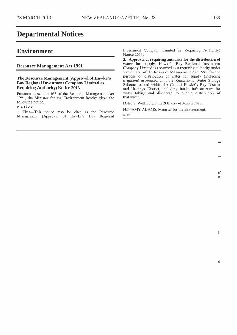
28 MARCH 2013 NEW ZEALAND GAZETTE, No. 38 1139
Departmental Notices
Environment
Resource Management Act 1991
The Resource Management (Approval of Hawke’s Bay Regional Investment Company Limited as Requiring Authority) Notice 2013 Pursuant to section 167 of the Resource Management Act 1991, the Minister for the Environment hereby gives the following notice. N o t i c e 1. Title—This notice may be cited as the Resource Management (Approval of Hawke’s Bay Regional
Investment Company Limited as Requiring Authority) Notice 2013. 2. Approval as requiring authority for the distribution of water for supply—Hawke’s Bay Regional Investment Company Limited is approved as a requiring authority under section 167 of the Resource Management Act 1991, for the purpose of distribution of water for supply (including irrigation) associated with the Ruataniwha Water Storage Scheme located within the Central Hawke’s Bay District and Hastings District, including intake infrastructure for water taking and discharge to enable distribution of that water. Dated at Wellington this 20th day of March 2013. HON AMY ADAMS, Minister for the Environment. go1888
Health
Medicines Act 1981
Consent to the Distribution of a New Medicine Pursuant to section 20 of the Medicines Act 1981, the Minister of Health hereby consents to the distribution in New Zealand of the new medicine which was referred to the Minister of Health under the provisions of section 24(5) of the Act and is set out in the Schedule hereto: ScheduleProduct: Myozyme Active Ingredient: Alglucosidase alfa 52.5mg Dosage Form: Powder for infusion concentrate New Zealand Sponsor: sanofi-aventis new zealand limited Manufacturers: Genzyme Ireland Limited, Waterford, Ireland
Hospira Inc, Kansas, United States of America
Dated this 21st day of March 2013. DR DON MACKIE, Chief Medical Officer, Clinical Leadership, Protection and Regulation Business Unit, Ministry of Health (pursuant to delegation given by the Minister of Health on 6 July 2001). go1816
Consent to the Distribution of New Medicines Pursuant to section 20 of the Medicines Act 1981, the Minister of Health hereby consents to the distribution in New Zealand of the new medicines set out in the Schedule hereto: ScheduleProduct: Concentrated Haemodialysis Solution Formula NGF - Part A (Article No. 2895) Active Ingredients: Acetic acid 8.4g/L
Calcium chloride dihydrate 6.5g/L Glucose 34.7g/L Magnesium chloride hexahydrate 3.6g/L Sodium chloride 214.8g/L
Dosage Form: Dialysis solution New Zealand Sponsor: Fresenius Medical Care Australia Pty Limited (NZ) Manufacturer: Fresenius Medical Care Australia Pty Limited, Smithfield, Australia


