
1
Atmospheric Correction for Dust Contaminated Ocean Regions
Menghua Wang and Wei Shi NOAA/NESDIS/STAR
E/RA3, Room 102, 5200 Auth Rd. Camp Springs, MD 20746, USA
Report of FY11 NASA ACE Funded Project March 14, 2012
Acknowledgements: We thank Oleg Dubovik and the AERONET group for providing dust model data. MODIS and CALIPSO data were obtained from NASA/GSFC and NASA Langley Research Center Atmospheric Science Data Center.
2
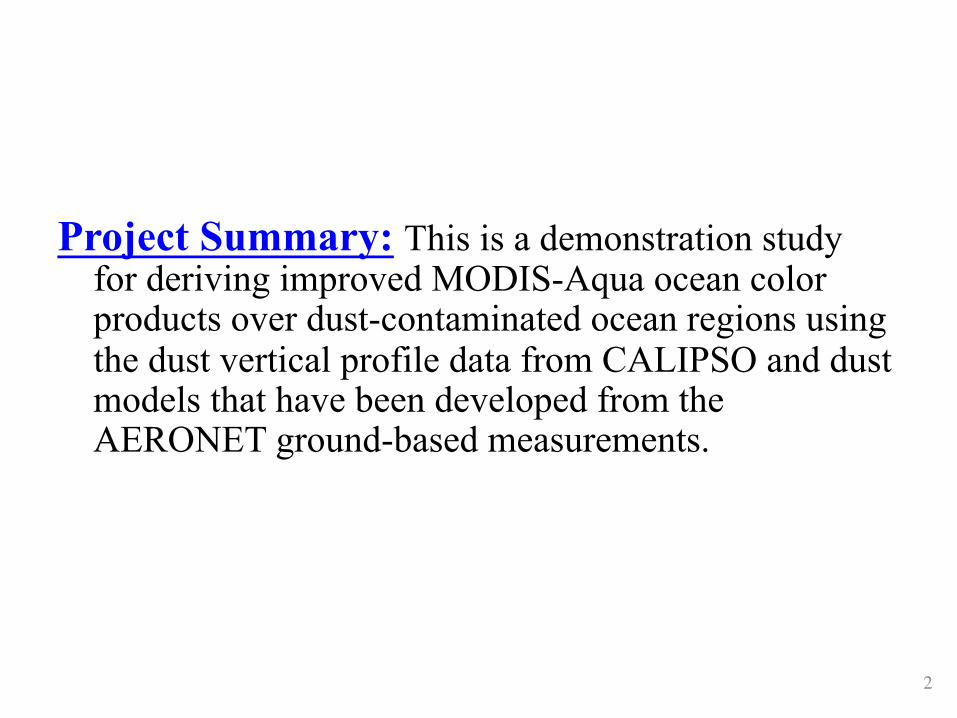
Project Summary: This is a demonstration study for deriving improved MODIS-Aqua ocean color products over dust-contaminated ocean regions using the dust vertical profile data from CALIPSO and dust models that have been developed from the AERONET ground-based measurements.

3
Current Satellite Ocean Color Retrievals Under Dust Condi;on
1. World oceans are frequently covered with dust, especially in the West Africa coast, Arabian Sea and Persian Gulf, US west coast, etc.
2. Dust aerosols are strongly absorbing in the blue and deep blue band.
3. Current aerosol models for satellite ocean color processing are not working under dust condiPon (also need aerosol verPcal distribuPon info).
4. Shi and Wang (2007) developed a method to detect absorbing aerosols, e.g., dust, smoke.
Shi, W., and Wang, M. (2007), Detection of turbid waters and absorbing aerosols for the MODIS ocean color data processing, Remote Sens. Environ., 110, 149-161.

4
Efforts in Addressing Absorbing Aerosol Issue Ø There have been significant efforts for addressing dust aerosol issue & its
effects on ocean color remote sensing (list a few): – Gordon, H. R., Du, T., and Zhang, T. (1997), Remote sensing of ocean color and aerosol
properties: resolving the issue of aerosol absorption, Appl. Opt., 36, 8670-8684. – Fukushima, H., and Toratani, H. (1997), Asian dust aerosol: optical effect on satellite
ocean color signal and a scheme of its correction, J. Geophys. Res., 102, 17119-17130. – Moulin, C., Gordon, H. R., Banzon, V. F., and Evans, R. H. (2001a), Assessment of
Saharan dust absorption in the visible from SeaWiFS imagery, J. Geophys. Res., 106, 18,239-218,249.
– Moulin, C., Gordon, H. R., Chomko, R. M., Banzon, V. F., and Evans, R. H. (2001b), Atmospheric correction of ocean color imagery through thick layers of Saharan dust, Geophys. Res. Letters, 28, 5-8.
– Claustre, H., Morel, A., Hooker, S.B., Babin, M., Antoine, D., Oubelkheir, K., Bricaud, A., Leblanc, K., Queuiner, B. and Maritorena, S. (2002), Is desert dust making oligotrophic water greener? Geophy. Research Letter, 29, 1469, doi: 10.1029/2001GL014056.
– Cattrall, C., Carder, K. L., and Gordon, H. R. (2003), Columnar aerosol single-scattering albedo and phase function retrieved from sky radiance over the ocean: Measurements of Saharan dust, J. Geophys. Res., 108 (D9), 4287, doi:10.1029/2002JD002497.
– Wiggert, J. D., Murtugudde, R. G. and Christian, J. R. (2006), Annual ecosystem variability in the tropical Indian Ocean: Results of a coupled bio-physical ocean general circulation model. Deep-Sea Research Part II, 53: 644-676.

5
AERONET Dust Aerosol Model Ø AERONET dust models developed by Dubovik et al. are used for
generating aerosol lookup tables: – Dubovik, O., Holben, B. N., Eck, T. F., Smirnov, A., Kaufman, Y. J., King,
M. D., Tanre, D., and Slutsker, I. (2002a), Variability of absorption and optical properties of key aerosol types observed in worldwide locations, J. Atmos. Sci., 59, 590-608.
– Dubovik, O., Holben, B. N., Lapyonok, T., Sinyuk, A., Mishchenko, M., Yang, P., and Slutsker, I. (2002b), Non-spherical aerosol retrieval method employing light scattering by spheroids, Geophy. Res. Lett., 29, 1451, doi:1410.1029/2001GL014506.
– Dubovik, O., Sinyuk, A., Lapyonok, T., Holben, B. N., Mishchenko, M., Yang, P., Eck, T. F., Volten, H., Munoz, O., Veihelmann, B., Zande, W. J. v. d., Leon, J.-F., Sorokin, M., and Slutsker, I. (2006), Application of spheroid models to account for aerosol particle nonsphericity in remote sensing of desert dust, J. Geophys. Res., 111, D11208, doi:11210.11029/12005JD006619.

6
Dust Aerosol Sca<ering Phase Func;on
10-1
100
101
102
0 30 60 90 120 150 180
412 nm555 nm667 nm869 nm1240 nm2130 nm
Scattering Angle (Deg.)
(a)
Phas
e Fu
nctio
n

7
Dust Aerosol Proper;es: Single-‐sca<ering Albedo and Asymmetry Parameter
• Dust property varies with wavelength, in parPcularly, in visible bands. • Dust parPcles are almost non-‐absorbing at the NIR and SWIR bands, while they are absorbing at visible bands. 0.6
0.7
0.8
0.9
1
1.1
400 800 1200 1600 2000
Single-Scat AlbedoAsymmetry Parameter
Wavelength (nm)
Dust
Opt
ical P
aram
eter
(b)

8
Dust Aerosol Lookup Tables Ø Dust aerosol lookup tables (including atmospheric diffuse
transmittance tables) were generated with the vector radiative transfer model for different aerosol vertical profiles located at (from bottom): 0-km, 1-km, 2-km, 4-km, 6-km, 8-km, 10-km, and 99-km.
Ø 4 dust aerosol size distributions corresponding to AOT at 1020 nm of 0.3, 0.6, 1.0, and 1.5.
Ø 14 dust AOT at 865 nm are: 0.02, 0.05, 0.1, 0.15, 0.2, 0.3, 0.4, 0.6, 0.8, 1.0, 1.5, 2.0, 2.5, 3.0.
Ø Solar-zenith angles from 0 to 80 (Deg.) at every 2.5 (Deg.). Ø Sensor-zenith angles from 1 to 75 (Deg.) at every ~2 (Deg.). Ø Relative azimuth angle from 0 to 180 (Deg.) at every 10 (Deg.). Ø MODIS 16 spectral bands at 412, 443, 469, 488, 531, 551, 555,
640, 667, 678, 748, 859, 869, 1240, 1640, and 2130 nm.

9
TOA Reflectance
10-2
10-1
400 800 1200 1600 2000
τa(869) = 0.1τa(869) = 0.3
τa(869) = 0.6τa(869) = 1.0
TOA
Refle
ctan
ce
Wavelength (nm)
TOA Typical Radiance, θ0 = 20o, θ = 45o, Δφ = 90oAERONET Dust Model, 4km Layer, Black Ocean
(c)

10
Effects of Dust Aerosol Ver;cal Distribu;on
0
0.005
0.01
0.015
400 500 600 700 800
1km vs. 3km bottom-layer1km vs. 6km bottom-layer1km vs. 9km bottom-layer
TOA
Refle
ctan
ce D
iffer
ence
Wavelength (nm)
τa(869) = 0.6, θ0 = 60o, θ = 45o, Δφ = 90o
AERONET Dust Model, Black Ocean
(d)
11
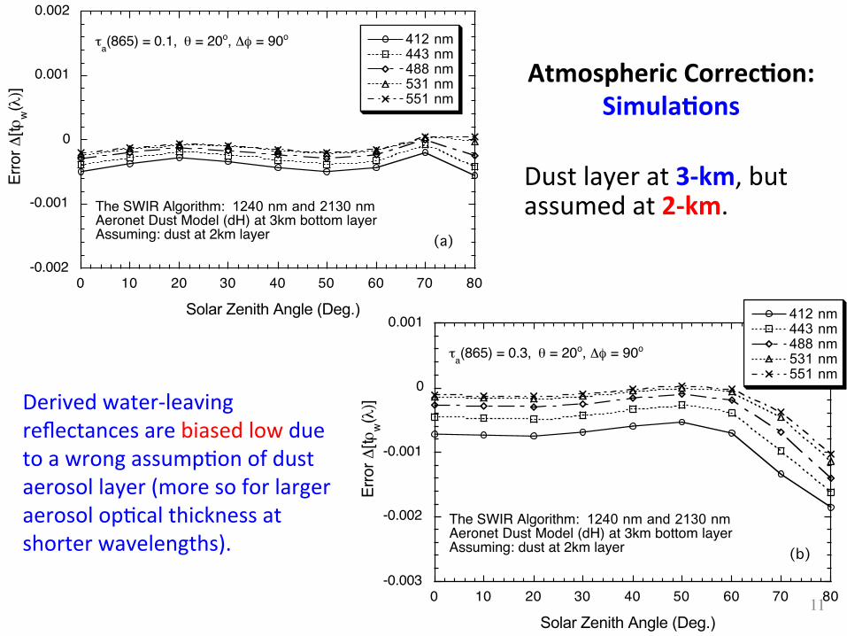
Atmospheric Correc;on: Simula;ons
-0.002
-0.001
0
0.001
0.002
0 10 20 30 40 50 60 70 80
412 nm443 nm488 nm531 nm551 nm
Solar Zenith Angle (Deg.)
τa(865) = 0.1, θ = 20o, Δφ = 90o
(a)
Erro
r Δ[t ρ
w(λ) ]
The SWIR Algorithm: 1240 nm and 2130 nmAeronet Dust Model (dH) at 3km bottom layerAssuming: dust at 2km layer
-0.003
-0.002
-0.001
0
0.001
0 10 20 30 40 50 60 70 80
412 nm443 nm488 nm531 nm551 nm
Solar Zenith Angle (Deg.)
τa(865) = 0.3, θ = 20o, Δφ = 90o
(b)
Erro
r Δ[tρ
w( λ)]
The SWIR Algorithm: 1240 nm and 2130 nmAeronet Dust Model (dH) at 3km bottom layerAssuming: dust at 2km layer
Derived water-‐leaving reflectances are biased low due to a wrong assumpPon of dust aerosol layer (more so for larger aerosol opPcal thickness at shorter wavelengths).
Dust layer at 3-‐km, but assumed at 2-‐km.

12
NASA Cloud-‐Aerosol Lidar and Infrared Pathfinder Satellite Observa;on (CALIPSO)
• Launched on April 28, 2006 • Part of the Aqua satellite constellaPon (or A-‐Train) • CALIPSO lags MODIS-‐Aqua by 1 to 2 minutes. • Wavelengths: 532 nm & 1064 nm • Pulse energy: 110 mJoule/channel • Footprint/FOV: 100 m/ 130 µrad • VerPcal resoluPon: 30-‐60 m • Horizontal resoluPon: 333 m

13
CALIPSO L2 Aerosol & Cloud Products
An example of data collected by CALIPSO's lidar in June 2006 Aerosols
• Height, Thickness • OpPcal depth, τ • Backscager, & betaa(z) • ExPncPon, σa
Clouds • Height • Thickness • OpPcal depth, τ • Backscager, &betac(z) • ExPncPon, σc • Ice/water phase • Ice cloud emissivity, ε • Ice parPcle size

14
CASE ONE : Dust In Japan Sea on 5/26/2007 MODIS Granule (2007146)
Calipso track
Dust height 0–2.5 km
MODIS True Color Image and CALIPSO Track 532 nm total agenuated backscager
0 0.01 sr-‐1km-‐1

15
CASE ONE : Ocean Color Retrieval Comparison MODIS Granule (2007146) With A No Dust Case on 5/22/2007
nLw412-‐NIR-‐02dust nLw412-‐NIR nLw412-‐NIR 5/22/2007
nLw443-‐NIR-‐02dust nLw443-‐NIR nLw443-‐NIR 5/22/2007
Spectral comparison
0 3.0 mW/cm3 µm sr
No Dust
No Dust

16
nLw667-‐NIR-‐02dust nLw667-‐NIR nLw667-‐NIR 5/22/2007
0 1.0 mW/cm3 µm sr
CASE ONE : Ocean Color Retrieval Comparison MODIS Granule (2007146) With a No Dust Case on 5/22/2007
No Dust

17
Taua531 comparison along the track of CALIPSO
CASE ONE : Ocean Color Retrieval Comparison MODIS Granule(2007146)

18
Spectral comparison at locaPon of [38.42°N, 135.90°E] (marked in the Calipso Track marked in 2007146)
CASE ONE : Ocean Color Retrieval Comparison MODIS Granule (2007146)
Old
New
No Dust Case

19
Total Agenuated Backscager
CASE 2 : Dust Gulf of OMAN on 5/26/2007
0 0.01 sr-‐1km-‐1
MODIS Granule: 2006326
Dust Height 0 -‐ 1.5 km

20
CASE 2: Comparison of ocean color products from NIR-‐dust and NIR nLw(412)
nLw(443)
Dust NIR-‐02km Corr. Standard NIR Corr.
MODIS Granule: 2006326
0 3.0 mW/cm3 µm sr

21
nLw(488)
nLw(551)
Dust NIR-‐02km Corr. Standard NIR Corr.
CASE 2: Comparison of ocean color products from NIR-‐dust and NIR
MODIS Granule: 2006326
0 3.0 mW/cm3 µm sr

22
nLw(667)
scale:0 -‐ 1
Ch
la
Scale:0.1 – 32 log
Dust NIR-‐02km Corr. Standard NIR Corr.
CASE 2: Comparison of ocean color products from NIR-‐dust and NIR
MODIS Granule: 2006326
0 1.0 mW/cm3 µm sr
0.1 32 mg/m3

23
AOT(531)
scale:0 -‐ 0
.6
AOT(869)
Scale:0.-‐ 0
.6
Dust NIR-‐02km Corr. Standard NIR Corr.
Spectral Comparison
CASE 2: Comparison of ocean color products from NIR-‐dust and NIR
MODIS Granule: 2006326
0.6 0.0

24
Taua531 Comparison along Calipso Track Spectral Comparison at [22.34°N, 61.97°E]
CASE 2: Comparison of ocean color products from NIR-‐dust and NIR
MODIS Granule: 2006326
Old
New

25
Atmospheric Correction for Dust Contaminated Ocean Region
Menghua Wang and Wei Shi
CALIPSO Data Provide Dust Height
MODIS True Color Image (Gulf of Oman)
Nov. 22, 2006
Region is covered by dust
nLw(443) from the standard-NIR method: significantly biased low values over the region.
nLw(443) from a new approach, dust models & dust height, show increased / improved results.
Chlorophyll-a from a new approach, clearly show ocean features (e.g., eddies).
CALIPSO Track
Old Results
New Results
New Results
Ø Improved ocean color products Ø Use realistic dust aerosol models Ø CALIPSO data--dust height information Ø Promising from preliminary results

26
Conclusions
Ø For ocean color remote sensing over dust contaminated ocean regions, we need realistic dust aerosol models and dust vertical distribution (~0.5-1km) information. Ø We demonstrate an approach to carry out atmospheric correction for satellite ocean color observations under dust conditions using AERONET dust models and dust height information from CALIPSO measurements. With this approach, ocean color results (nLws) are improved. Ø Dust aerosol height along the CALIPSO tracking are assumed to be representative for the entire dust region. This might not be accurate and can lead to errors in nLw retrievals. Ø Future research is still necessary on improving dust aerosol models, how to effectively/accurately obtain aerosol height information (e.g., its spatial distribution), algorithm implementation, etc., in atmospheric correction for satellite ocean color products.


