Arpley Landfill Site Pavement Report Warrington Borough Council
July 2012
Arpley Landfill Site Pavement Report
Atkins Arpley Landfill Site - Pavement Report | Version 2.0 | July 2012 2
Notice This document and its contents have been prepared and are intended solely for Warrington Borough Council’s information and use in relation to the condition of the pavements adjacent to Arpley Landfill.
Atkins assumes no responsibility to any other party in respect of or arising out of or in connection with this document and/or its contents.
This document has 36 pages including the cover.
Document history
Job number: 5110765 Document ref: Pavement Report
Revision Purpose description Originated Checked Reviewed Authorised Date
Rev 1.0 For Comment JM JPG SJ GR 10/05/12
Rev 2.0 Final issue JM JPG SJ GR 04/07/12
Client signoff
Client Warrington Borough Council
Project Arpley Landfill Site Highways and Environmental Consultancy Support
Document title Arpley Landfill Site - Pavement Report
Job no. 5110765
Copy no.
Document reference
Pavement Report
Arpley Landfill Site Pavement Report
Atkins Arpley Landfill Site - Pavement Report | Version 2.0 | July 2012 3
Contents Section Page Notice 2
1. Introduction 4
Background 4
Site Location 4
2. Pavement Investigation 5
Scheme referencing system 5
Visual Condition 5
3. Existing Pavement Analysis 9
Construction 9
Trial Hole Plate Bearing Testing 10
Traffic 11
Standard Design 16
4. Assessment of Current Condition 17
5. Treatment Design 18
Constraints 18
Options 19
Recommendation 20
Tables Table 3.1 - Existing Pavement Construction from Cores 9 Table 3.2 - Existing Pavement Construction from Trial Pits 10 Table 3.3 - AADF Without Landfill Operation 11 Table 3.4 - AADF With Landfill Operation 12 Table 3.5 - Past Traffic Since Landfill Opening 12 Table 3.6 - 11 Year Design Traffic (2014 - 2025), Landfill operational 14 Table 3.7 - 11 Year Design Traffic (2014 - 2025), Landfill closure 14 Table 3.8 - 37 Year Design Traffic (1988 - 2025) 15 Table 5.1 – Extent of Recommended Treatment 20
Appendices A.1. Site Location Plan A.2. VCS Photographs A.3. VCS Plans A.4. Core Samples Location Plan A.5. Trial Pit Location Plan A.6. Traffic Figures A.7. Whole Life Cost A.8. Treatment Plan
Arpley Landfill Site Pavement Report
Atkins Arpley Landfill Site - Pavement Report | Version 2.0 | July 2012 4
1. Introduction 1.1. This report has been prepared on behalf of Warrington Borough Council (WBC) following the
receipt of the Arpley Landfill site Planning Application 2011 / 19244. In order to assess the impact of the proposal to extend the operation of the Landfill site to 2025 on the local highway network, the Local Authority have requested the following,
A summary analysis report of the Council’s recent trial hole plate bearing tests. Advice as to whether the current carriageway construction standards are suitable to
accommodate the traffic arising from the existing and proposed development.
1.2. This report presents the findings from the pavement cores, trial holes, plate bearing tests and the subsequent data analysis. Findings from the pavement investigation are presented, followed by treatment options and recommendations for further testing.
Background 1.3. Following receipt of the Planning Application from Waste Recycling Group (WRG) for the
extension of operation of Arpley Landfill, WBC conducted trial hole plate bearing tests and core sample testing on the local highway network. This formed the data handed over to Atkins for detailed analysis and review. Atkins was appointed in February 2012 to carry out this task and to ultimately provide advice as to whether the current carriageway construction standards are suitable to accommodate the HGV traffic arising from the proposed licence extension.
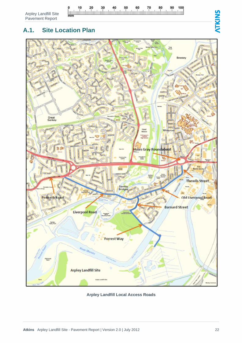
Site Location 1.4. Arpley Landfill is located in the Sankey Bridges area of Warrington. The highway network
considered for this investigation was the local highway network used by traffic to access the site. The network consists of Thewils Street, Old Liverpool Road, Liverpool Road, Barnard Street and Forrest Way.
1.5. A site location plan is included in Appendix A.1.
Arpley Landfill Site Pavement Report
Atkins Arpley Landfill Site - Pavement Report | Version 2.0 | July 2012 5
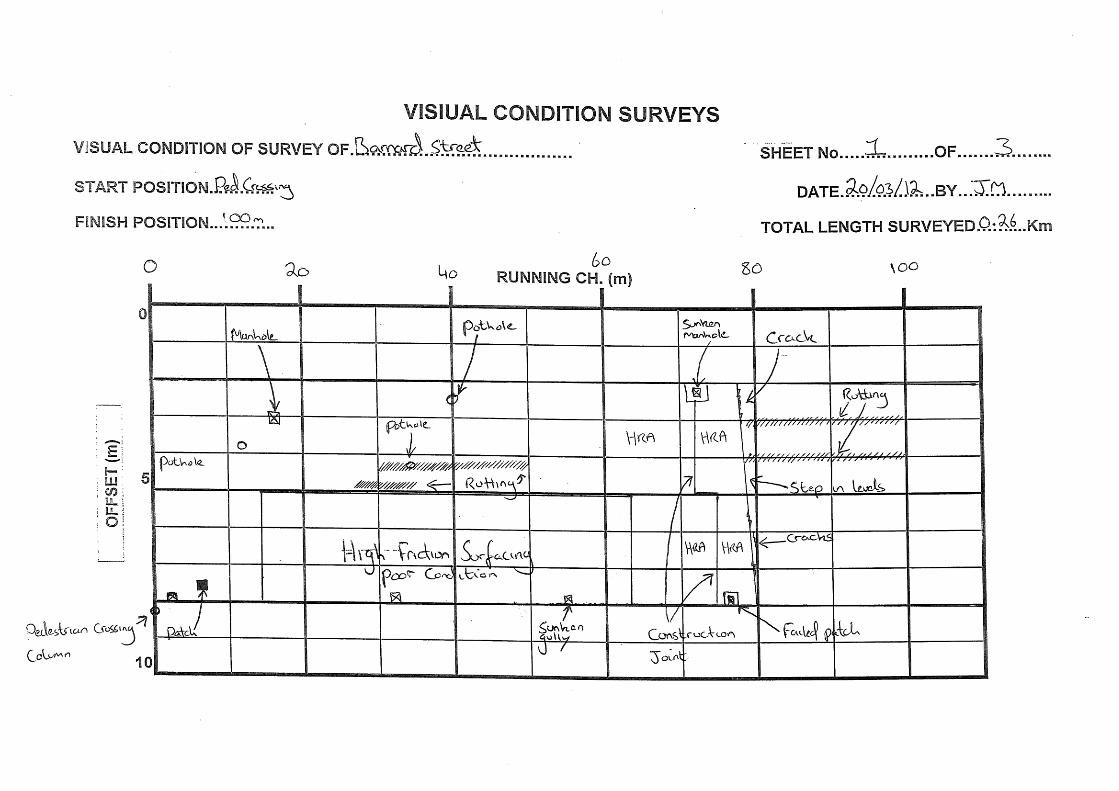
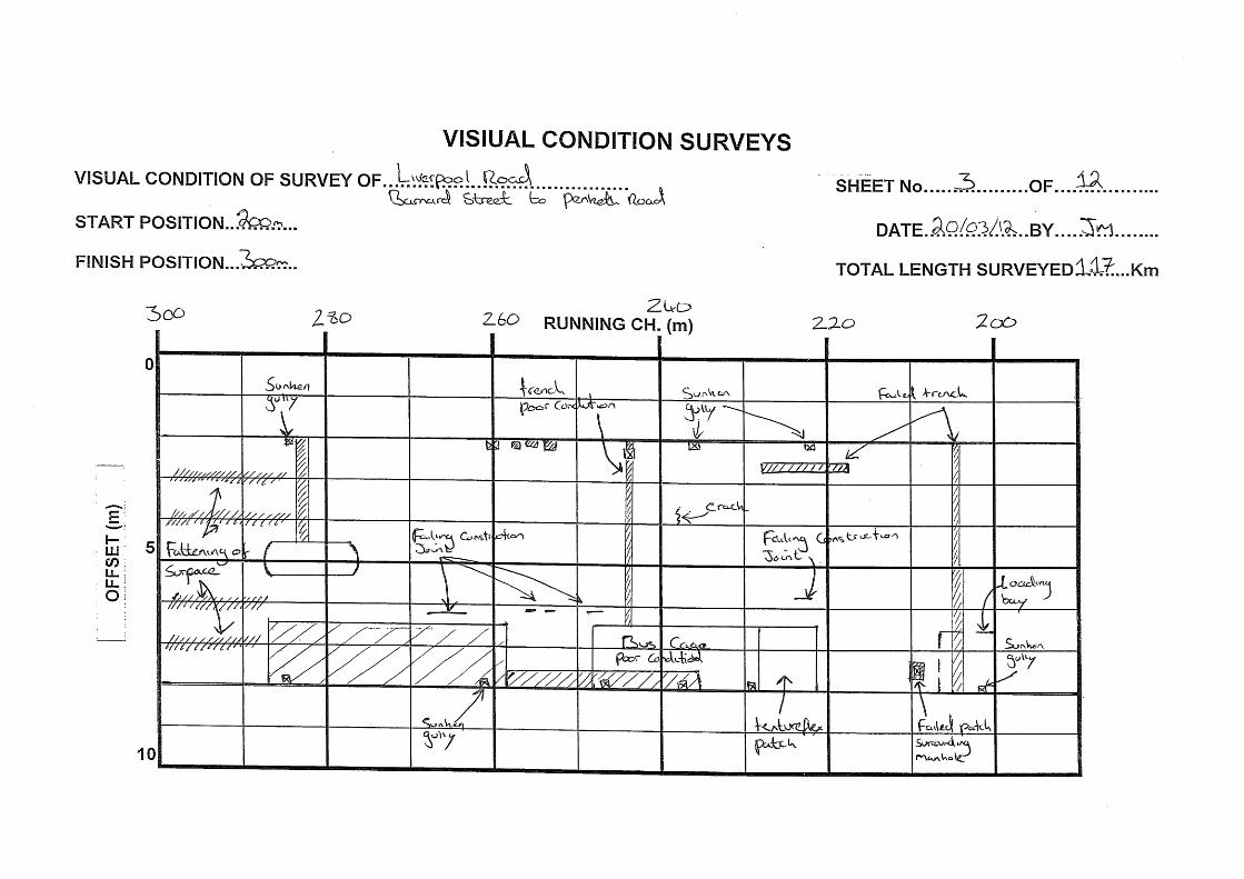
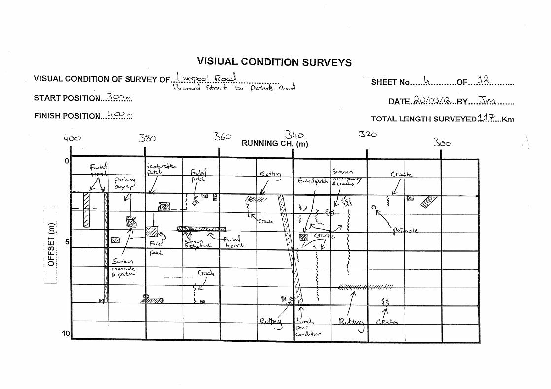
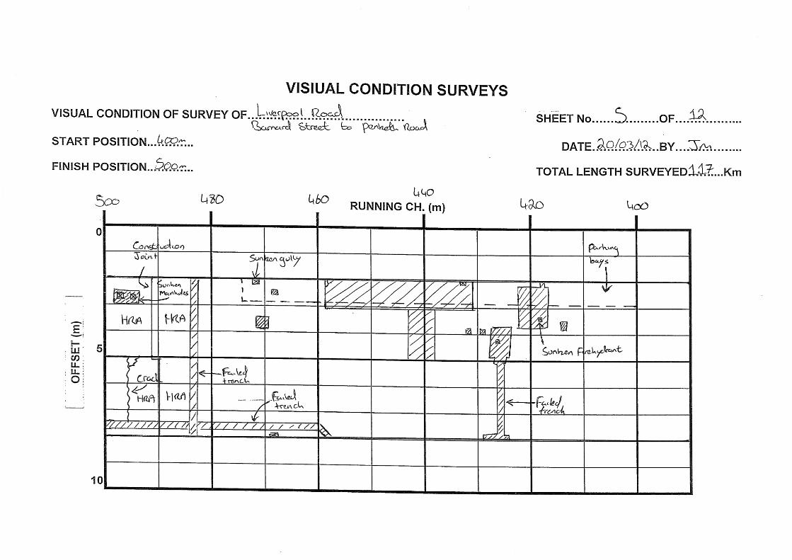
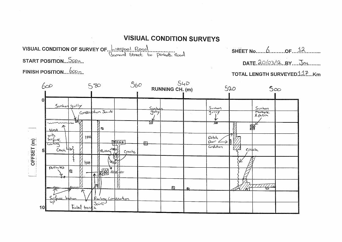
2. Pavement Investigation 2.1. In March 2012 Atkins undertook a pavement condition survey of this site. This consisted of a
visual condition survey (VCS) only and a review of the data provided by WBC. i.e. Core samples, trial pit logs and plate bearing test results.
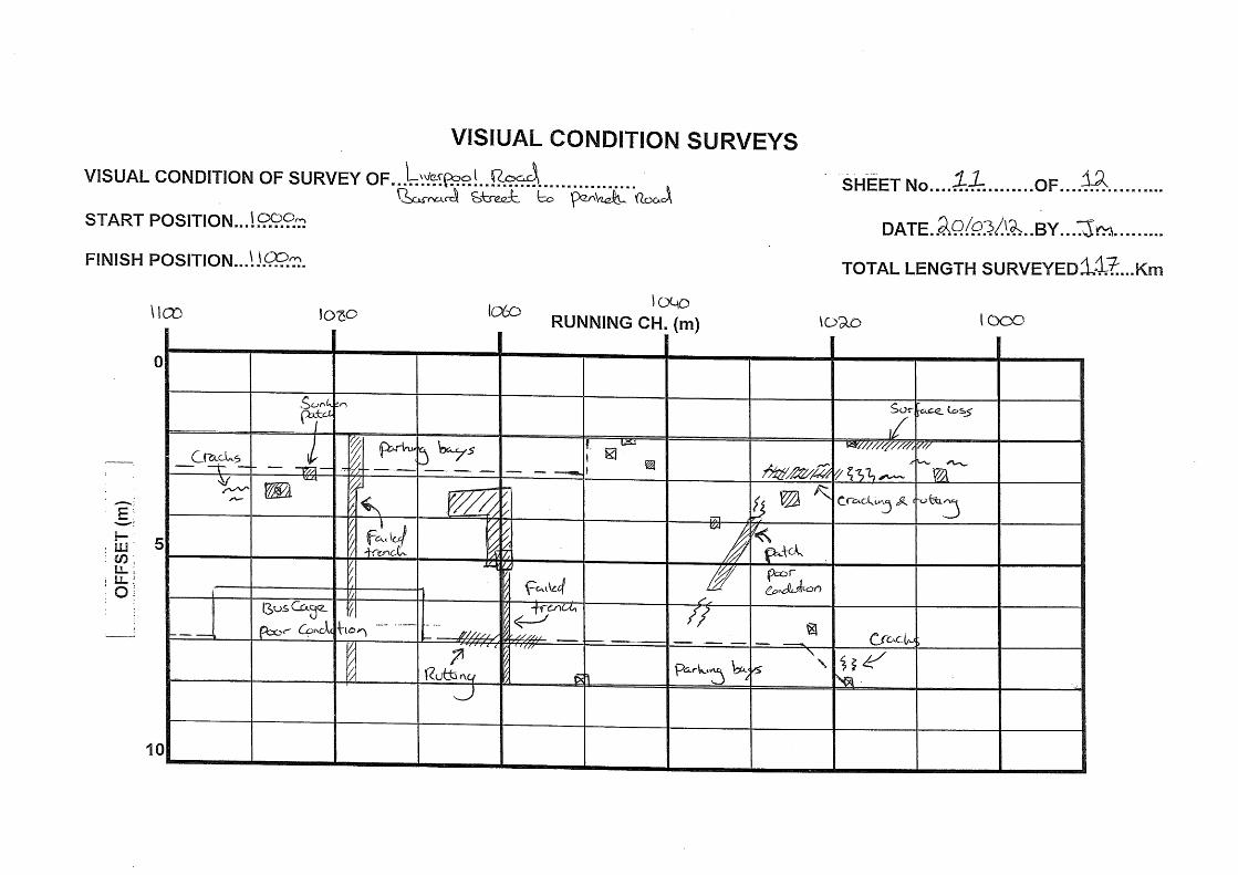
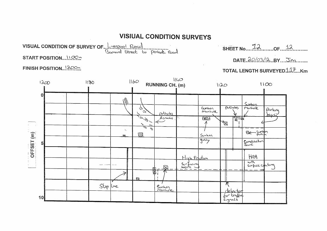
Scheme referencing system 2.2. The VCS was split into 4 sections. Sankey Island Roundabout to Barnard Street, Barnard Street to
Penketh Road, Barnard Street to Forest Way and Forest way to the Landfill entrance.
2.3. For the section between Sankey Island Roundabout and Barnard Street Chainage 0m was established at the easternmost end of Thewils Street at Sankey Island Roundabout in line with Lighting Column ref 184. This chainage increased in a westerly direction towards Barnard Street.
2.4. For the section of road between Barnard Street and Penketh Road Chainage 0m was established in line with the pedestrian crossing column on the westbound carriageway on the western edge of the junction with Barnard Street. The chainage increased in a westerly direction toward Penketh Road.
2.5. For the section of road between Barnard Street and Forest Way Chainage 0m was established at the northern end of Barnard Street in line with the pedestrian crossing column on the northbound carriageway. The chainage increased in a southerly direction towards Forest Way.
2.6. For the section of road between Forest Way and the Landfill entrance, chainage 0m was established at the northernmost end of Forest Way in line with lighting column ref 9. The chainage increased in a southerly direction towards the Landfill site entrance.
Visual Condition 2.7. A selection of the photographs taken during the VCS carried out on 14/03/12 & 20/03/12, are
included in Appendix A.2.
2.8. Atkins undertook a VCS in accordance with HD 29/081. The survey was split into 4 sections. The resultant VCS strip-plans are included in Appendix A.3. The main findings of the survey were as follows:
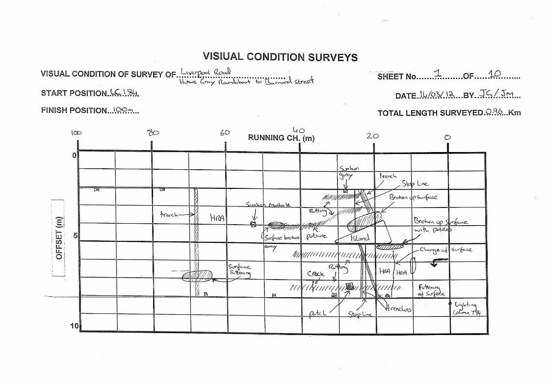
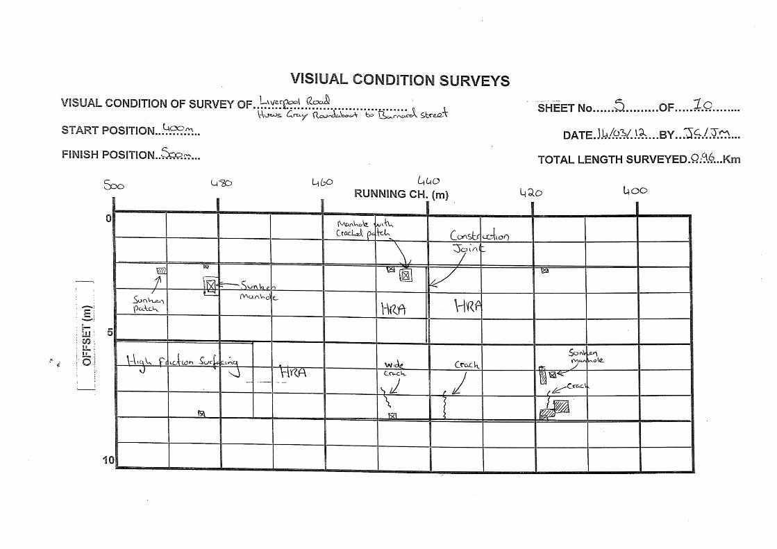
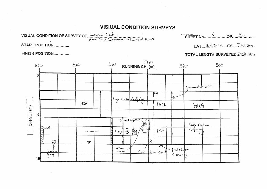
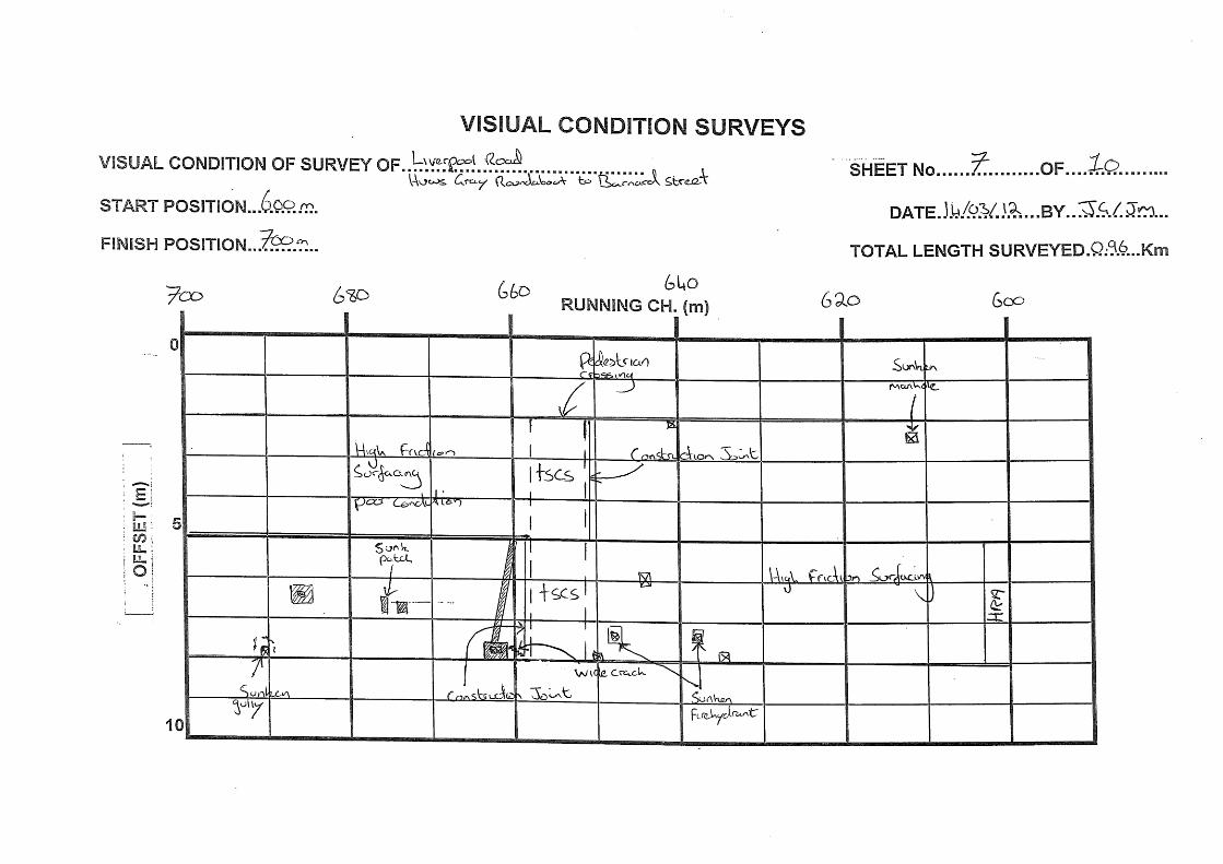
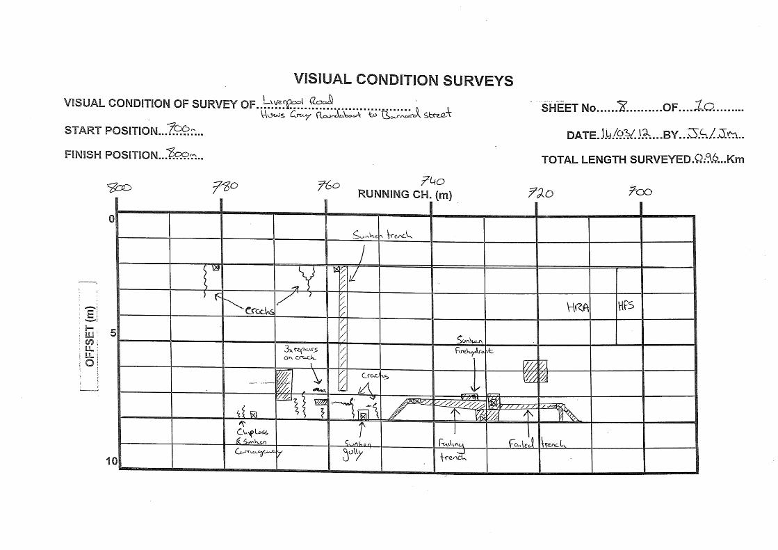
Sankey Island Roundabout to Barnard Street, chainage 0m to 960m. The Hot Rolled Asphalt (HRA) is generally in good condition with discrete lengths displaying concentrated defects.
(a) There a significant number of defects from chainage 0m to 100m. This is most likely due to the turning movements of HGVs on the exit and entrance to Sankey Island roundabout. The following defects were recorded between chainage 0m to 100m: - Rutting on the westbound carriageway between chainage 13m to 40m. Rutting on
the eastbound carriageway between chainage 21m to 45m.
- Broken up surface with a number of patch repairs from chainage 12m to 20m on the westbound carriageway. Broken up surface on the eastbound carriageway from chainage 17m to 26m and 43 to 49m.Pothole at chainage 37m on the eastbound carriageway.Sunken manhole at chainage 53m on the eastbound carriageway.
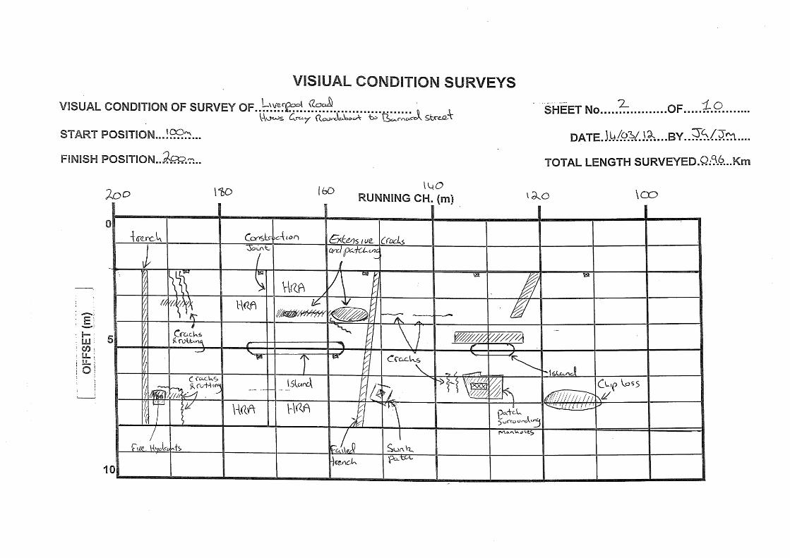
(b) The bend from Thewils Street round to Old Liverpool road, Chainage 100m to 200m also shows a significant number of defects. There is a pavement joint at chainage 170m
1 HD 29/08 – Data for Pavement assessment
Arpley Landfill Site Pavement Report
Atkins Arpley Landfill Site - Pavement Report | Version 2.0 | July 2012 6
between HRA surfaces, the joint appears however to be in good condition. The following defects were recorded around this bend: - A number of cracks at chainage 137m on the westbound carriageway. Longitudinal
cracking between chainage 137m to 142m and 145m to 150m on the eastbound carriageway. Extensive cracking and patchwork repairs between chainage 153m to 170m on the eastbound carriageway. A number of transverse cracks at chainage 190m on the eastbound carriageway.
- Transverse trench with extensive cracking at chainage 152m on the westbound carriageway.
- Offside wheel track rutting between chainage 187m to 193m on the westbound carriageway. Offside wheel track rutting between chainage 187m to 192m on the eastbound carriageway.
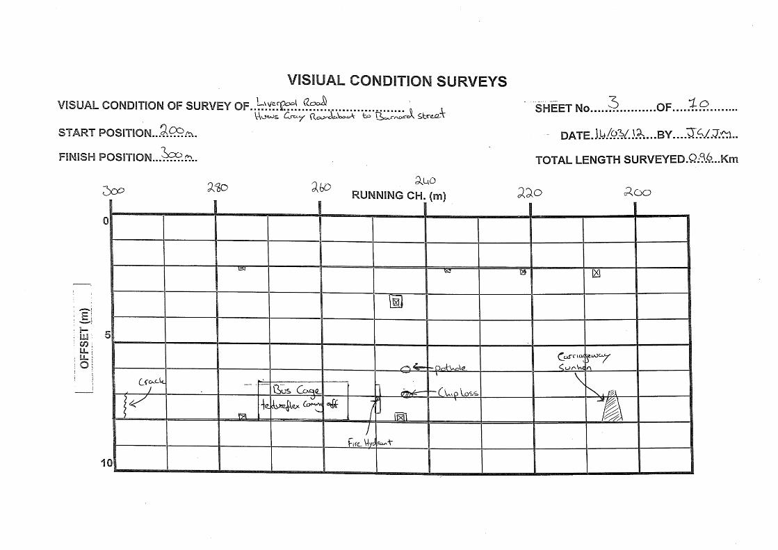
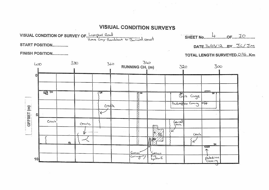
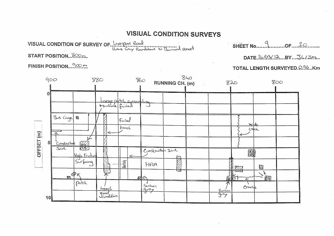
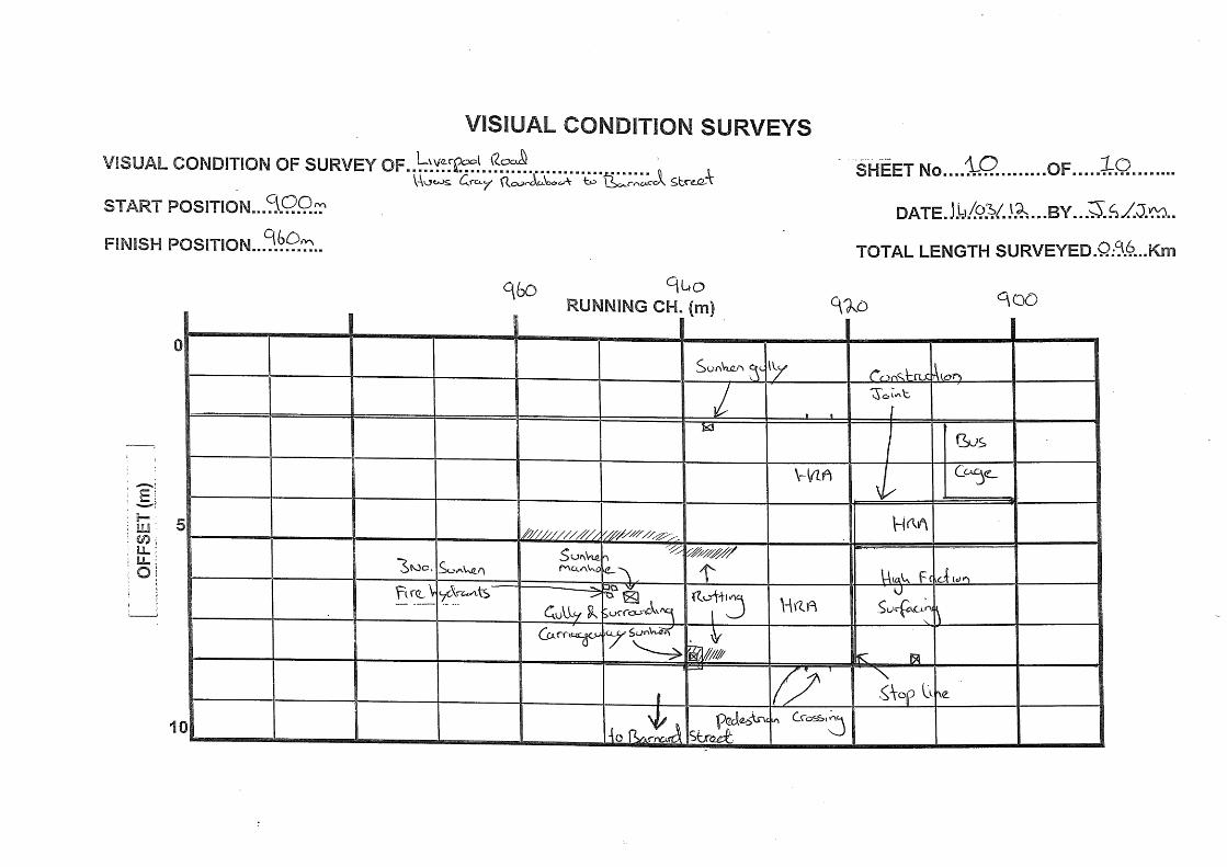
(c) The remainder of the road appears to be in good condition. There are a number of patchwork repairs and transverse trenches, some of which have failed. There are also a number of surface cracks and sunken iron work. There are 4 No. areas of high friction surfacing along this stretch of carriageway, all of which were in good condition. The following defects were recorded from chainage 200m to 960m: - Carriageway has sunk at chainage 205m and 305m on the westbound carriageway.
- Transverse crack from mid way across westbound carriageway to the kerb on the eastbound carriageway at chainage 367m. Transverse crack at chainage 273m and 448m on the westbound carriageway. Wide crack at chainage 817m on the eastbound carriageway.
- Sunken manhole at chainage 418m on the westbound carriageway, 480m & 542m on the eastbound carriageway. Large manhole patch surround has failed at chainage 884m on the eastbound carriageway.
- Sunken gullies at chainages 592m, 690m, 775m, 821m, 861m on the westbound carriageway and 937m on the eastbound carriageway.
- Failed longitudinal patch repair at chainage 715m to 742m on the westbound carriageway.
- Failed trench at chainage 756m across both carriageways. Failed trench at chainage 875m on the eastbound carriageway.Rutting from chainage 934 to 960m in the centre of the carriageway.
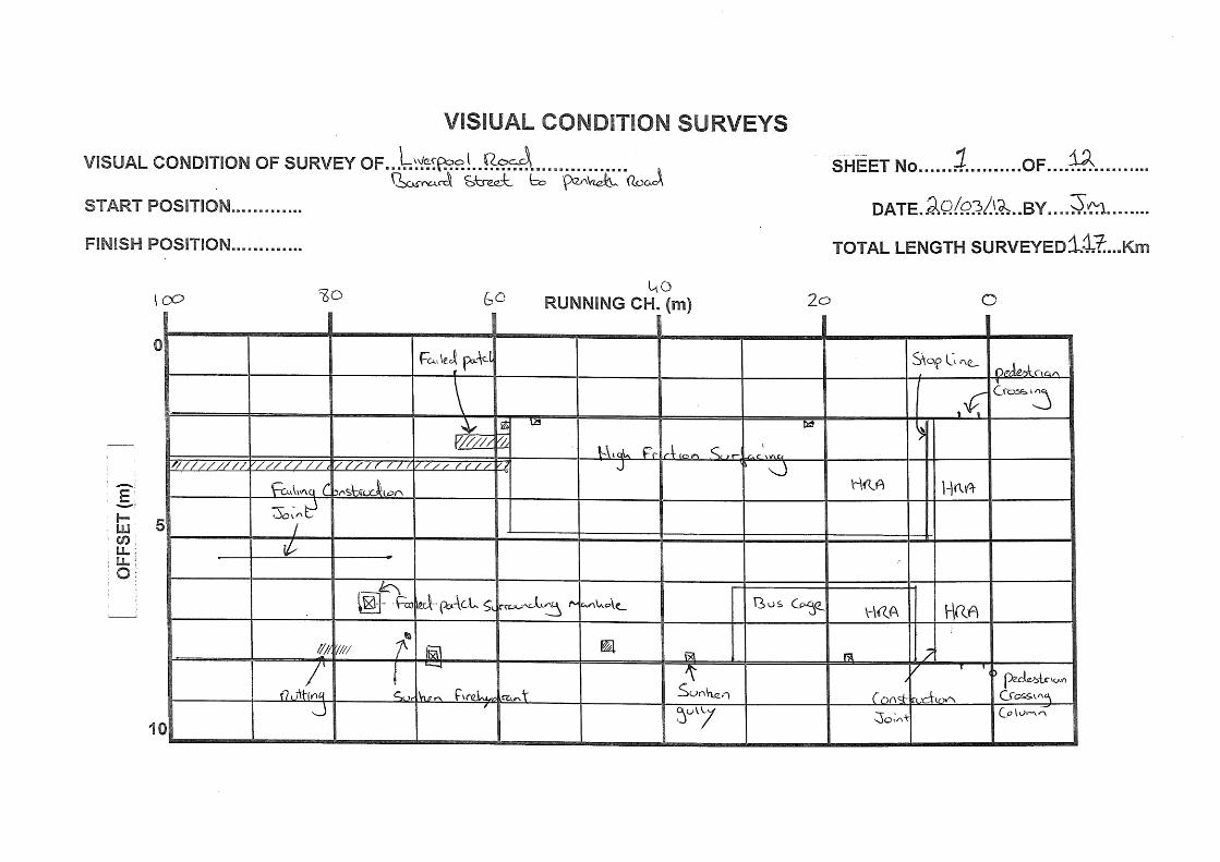
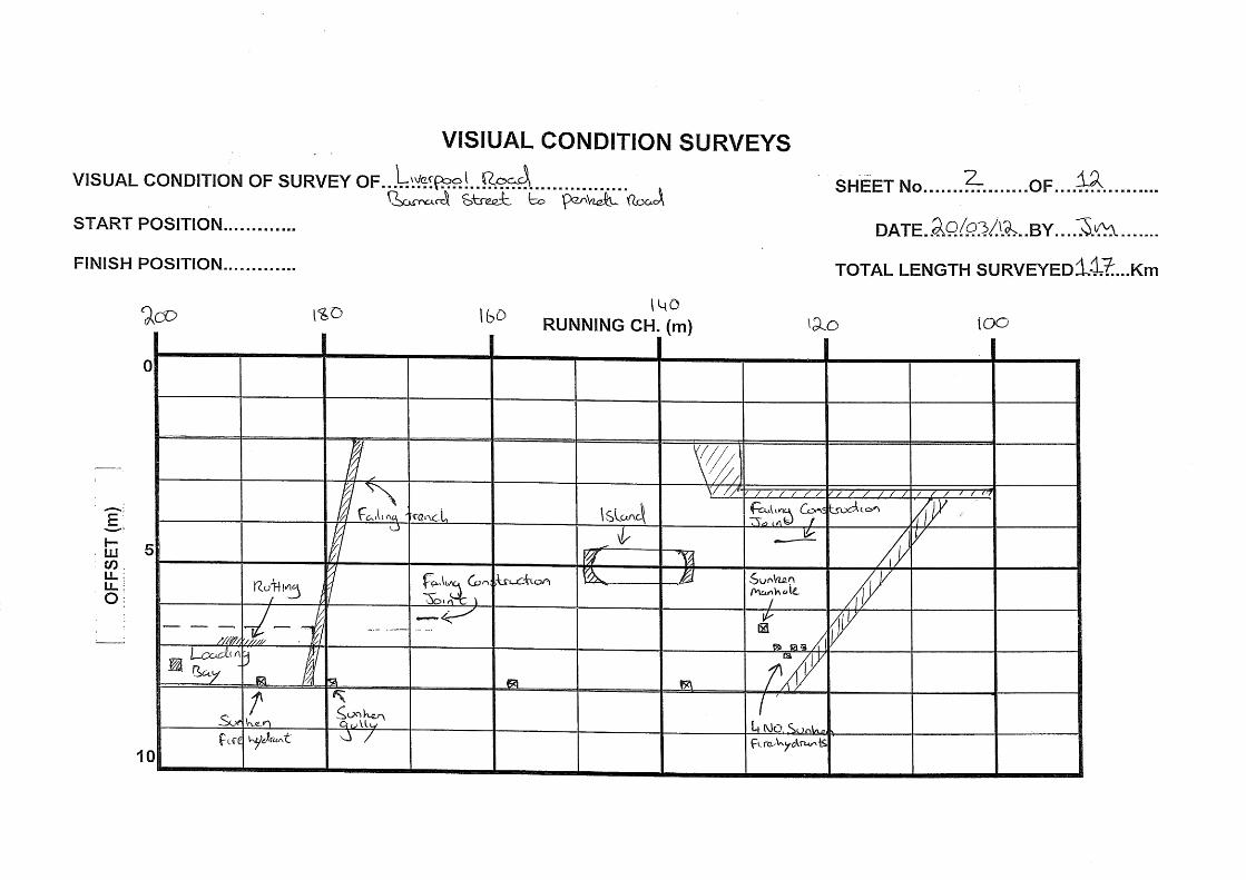
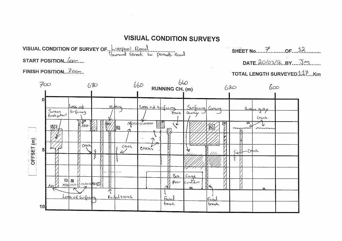
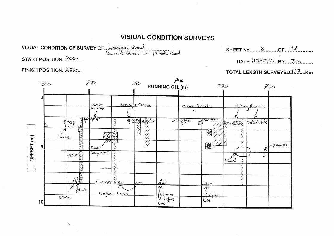
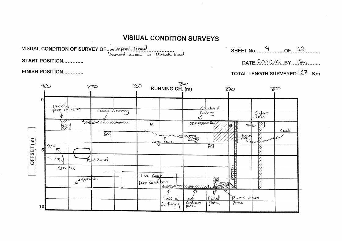
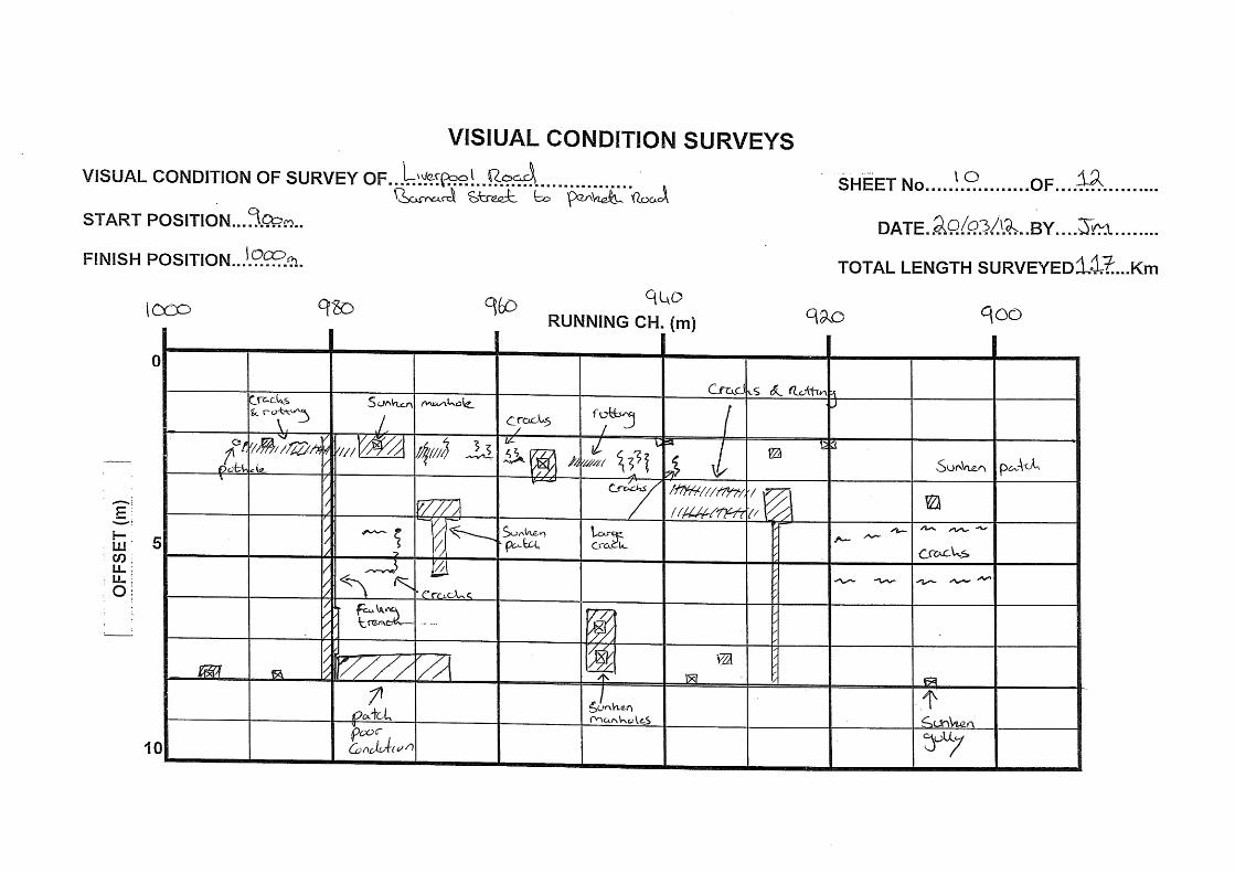
Barnard Street to Penketh Road, chainage 0m to 1190m:
(a) The HRA surface appears to be in good condition until chainage 585m where the surface has been overlaid with a 6/10mm surface dressing. Beyond this point there are a significant number of patch repairs, failed trenches, sunken ironwork and areas of rutting and cracking. There are a number of defects prior to this chainage. The defects recorded on this section of road from chainage 0m to 1190m are listed below: - Sunken manholes on the westbound carriageway at chainage 75m, 127m, 209m,
946m and 1145m. Sunken manholes on the eastbound carriageway at chainage, 382m, 495m, 510m, 974m, 1110m and 1117m.
- Sunken gullies on the westbound carriageway at chainage 27m, 180m, 201m, 262m, 298m, 571m and 908m. Sunken gullies on the eastbound carriageway at chainage 221m, 235m, 260m, 468m 472m, 525m, 554m, 586m, 673m and 1125m.
Arpley Landfill Site Pavement Report
Atkins Arpley Landfill Site - Pavement Report | Version 2.0 | July 2012 7
- Failed transverse trenches at chainage 180m, 200m, 340m, 390m, 482m, 578m, 584m, 645m, 653m, 981m and 1077m. Failed trenches on the westbound carriageway at chainages 458m to 511m & 1059m. Failed trenches on the eastbound carriageway at chainage 218m to 228m, 359m to 371m and 395m.
- Extensive rutting at chainage 314m to 328m on the westbound carriageway and 653m to 683m, 700m to 763m, 863m to 882m, 947m to 991m, 1018m to 1030m on the eastbound carriageway.
- Large cracks on the westbound carriageway at chainage 495m and 515m. Large cracks on the eastbound carriageway at chainage 325m to 340m, 600m to 619m and 839m to 859m.
- A number of large potholes and cracks at chainage 1150m to 1159m on the eastbound carriageway.
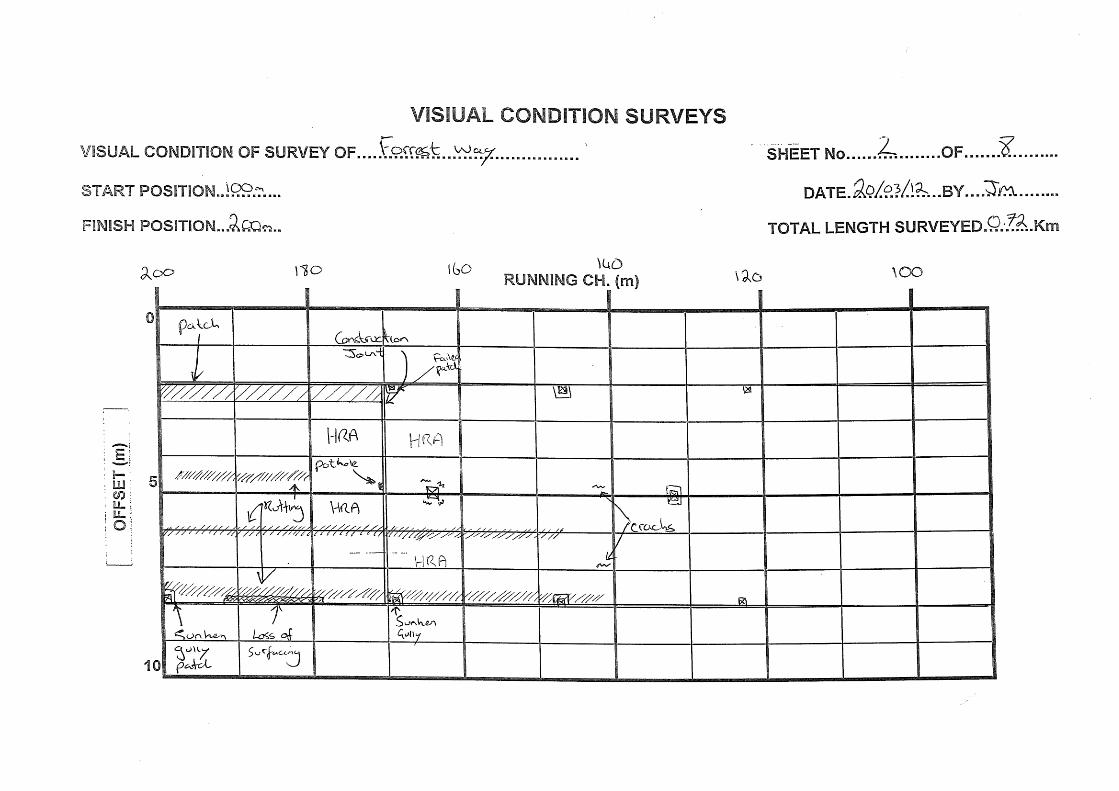
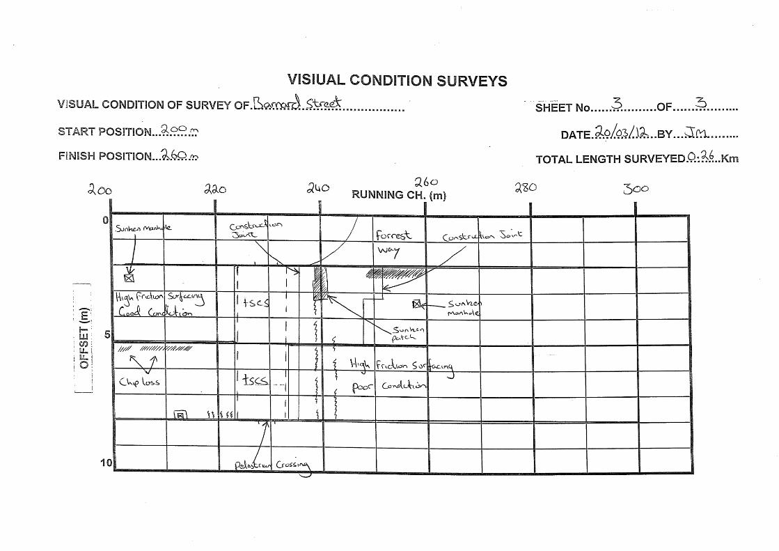
Barnard Street to Forrest Way chainage 0m to 260m:
(a) The HRA appears to be in good condition until chainage 236m with the junction with Forrest way where there are large cracks, areas of rutting and failed patches. There are two areas of high friction surfacing, the northern most area shows signs of deteriorating. The following major defects recorded over this stretch of carriageway are listed below; - Sunken manholes on the southbound carriageway at chainage 146m, 258m and
703m.
- Sunken gullies on the northbound carriageway at chainage 550m, 138m, 186m, 212m and 235m.
- Rutting on the southbound carriageway at chainage 28m to 51m, 79m to 113m and 248 to 260m. Rutting on the northbound carriageway at chainage 105m to 115m.
- Significant step in levels at chainage 78m and 113m. This is at the joint with the bridge deck. There are a number of transverse cracks along these chainages.
- Sunken patch repair on the southbound carriageway at chainage 240m.
- Large transverse crack at chainage 238m. There are a number of cracks adjacent this on the westbound carriageway.
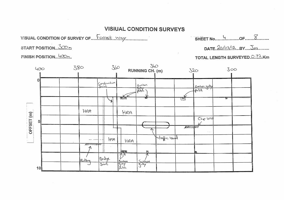
Forrest Way to Landfill entrance chainage 0m to 721m:
(a) The HRA is showing a number of large areas of rutting, in particular on the southbound carriageway. There are also a number of defects at the junction with Barnard Street. The following defects were recorded on this section of road; - Sunken manhole in the centre of the road at chainage 202m.
- Sunken gullies on the southbound carriageway at chainage 74m, 168m,199m, 239m, 260m, 345m, 355m, 357m, 697m and 718m. Sunken gullies on the northbound carriageway at chainage 20m, 325m, 344m, 355m and 357m.
- Failed transverse trench at chainage 83m and 550m
- Rutting on the southbound carriageway at chainage 12m to 20m, 142m to 240m, 368m to 377m, 420m to 455m, 529m to 542m, 606m to 621m, 705m to 708m and 718m. Rutting on the northbound carriageway at chainage 180m to 197m.
Arpley Landfill Site Pavement Report
Atkins Arpley Landfill Site - Pavement Report | Version 2.0 | July 2012 8
- Sunken patch at chainage 8m on the southbound carriageway. This has resulted in a large level difference with the adjacent carriageway.
- Longitudinal crack on the northbound carriageway at chainage 14m to 19m
2.9. The summary provided in section 2.8 shows that there are numerous sunken manholes/gullies
and failed trench reinstatements. These have resulted in several areas of uneven surface, crack development and pot holes. These surface undulations will lead to noise being generated from the passage of heavy goods vehicles along the surveyed highways. Of particular relevance to the landfill operation will be the noise caused by body roll of empty refuse vehicles.
Arpley Landfill Site Pavement Report
Atkins Arpley Landfill Site - Pavement Report | Version 2.0 | July 2012 9
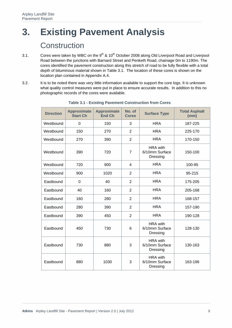
3. Existing Pavement Analysis Construction
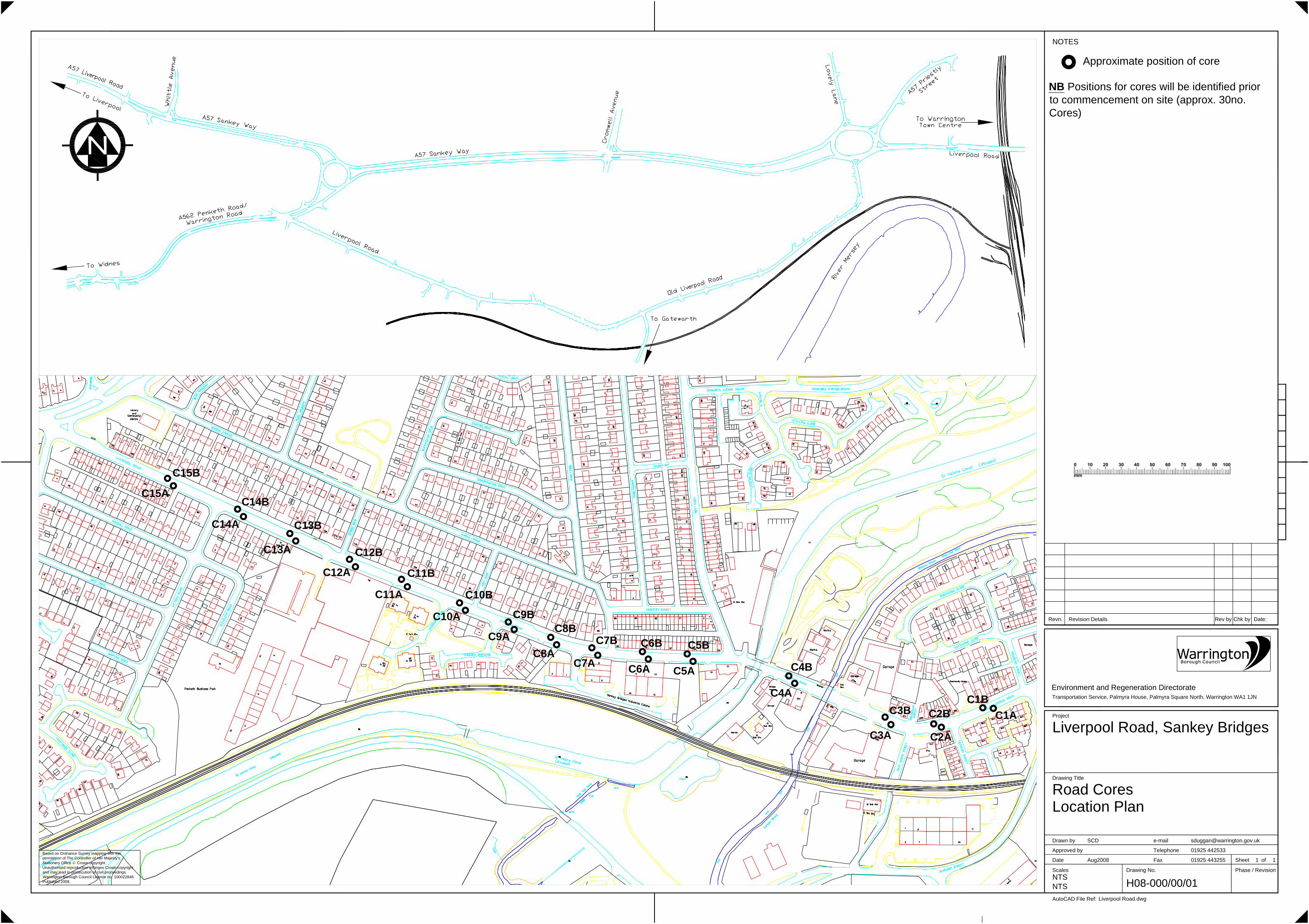
3.1. Cores were taken by WBC on the 9th & 10th October 2008 along Old Liverpool Road and Liverpool Road between the junctions with Barnard Street and Penketh Road, chainage 0m to 1190m. The cores identified the pavement construction along this stretch of road to be fully flexible with a total depth of bituminous material shown in Table 3.1. The location of these cores is shown on the location plan contained in Appendix A.4.
3.2. It is to be noted there was very little information available to support the core logs. It is unknown what quality control measures were put in place to ensure accurate results. In addition to this no photographic records of the cores were available.
Table 3.1 - Existing Pavement Construction from Cores
Direction Approximate
Start Ch Approximate
End Ch No. of Cores
Surface Type Total Asphalt
(mm)
Westbound 0 150 3 HRA 187-225
Westbound 150 270 2 HRA 225-170
Westbound 270 390 2 HRA 170-150
Westbound 390 720 7 HRA with
6/10mm Surface Dressing
150-100
Westbound 720 900 4 HRA 100-95
Westbound 900 1020 2 HRA 95-215
Eastbound 0 40 2 HRA 175-205
Eastbound 40 160 2 HRA 205-168
Eastbound 160 280 2 HRA 168-157
Eastbound 280 390 2 HRA 157-190
Eastbound 390 450 2 HRA 190-128
Eastbound 450 730 6 HRA with
6/10mm Surface Dressing
128-130
Eastbound 730 880 3 HRA with
6/10mm Surface Dressing
130-163
Eastbound 880 1030 3 HRA with
6/10mm Surface Dressing
163-196
Arpley Landfill Site Pavement Report
Atkins Arpley Landfill Site - Pavement Report | Version 2.0 | July 2012 10
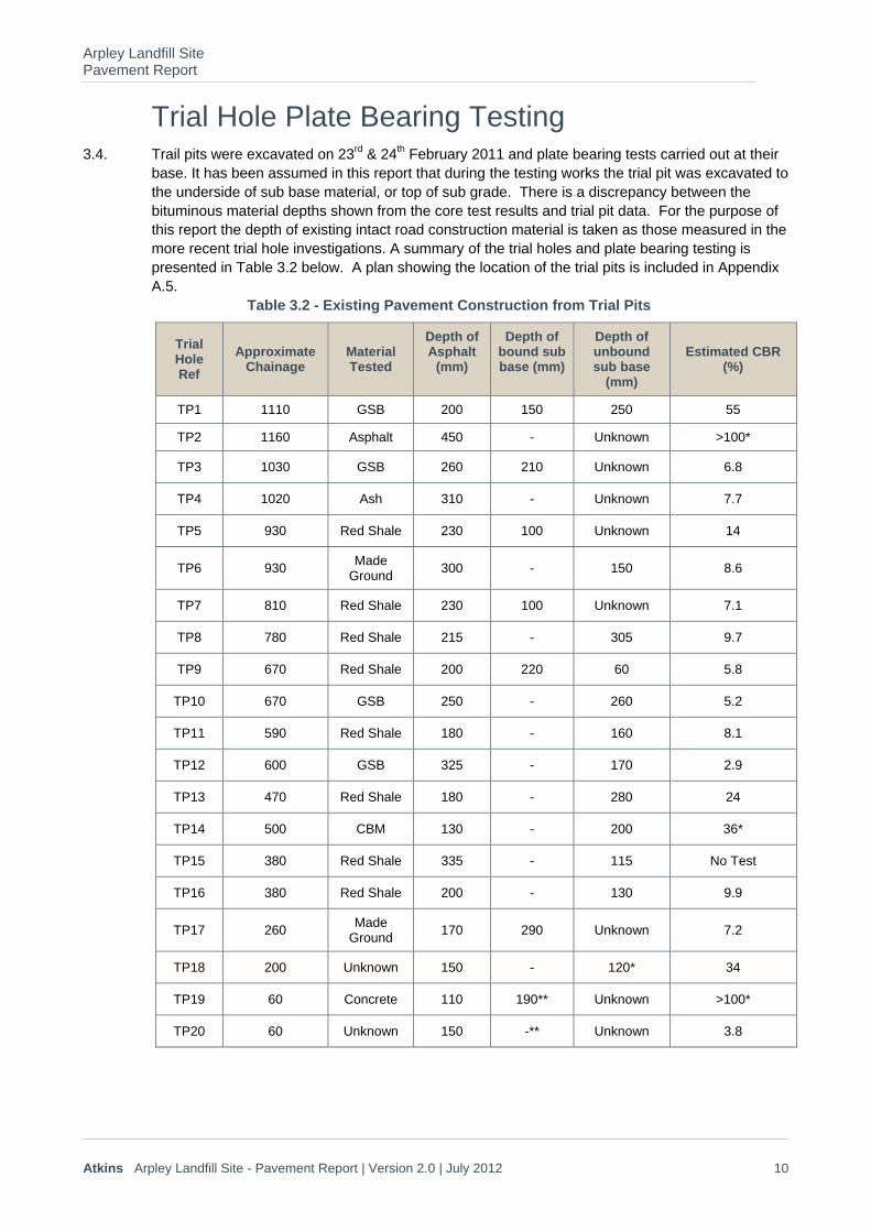
Trial Hole Plate Bearing Testing 3.4. Trail pits were excavated on 23rd & 24th February 2011 and plate bearing tests carried out at their
base. It has been assumed in this report that during the testing works the trial pit was excavated to the underside of sub base material, or top of sub grade. There is a discrepancy between the bituminous material depths shown from the core test results and trial pit data. For the purpose of this report the depth of existing intact road construction material is taken as those measured in the more recent trial hole investigations. A summary of the trial holes and plate bearing testing is presented in Table 3.2 below. A plan showing the location of the trial pits is included in Appendix A.5.
Table 3.2 - Existing Pavement Construction from Trial Pits
Trial Hole Ref
Approximate Chainage
Material Tested
Depth of Asphalt
(mm)
Depth of bound sub base (mm)
Depth of unbound sub base
(mm)
Estimated CBR (%)
TP1 1110 GSB 200 150 250 55
TP2 1160 Asphalt 450 - Unknown >100*
TP3 1030 GSB 260 210 Unknown 6.8
TP4 1020 Ash 310 - Unknown 7.7
TP5 930 Red Shale 230 100 Unknown 14
TP6 930 Made
Ground 300 - 150 8.6
TP7 810 Red Shale 230 100 Unknown 7.1
TP8 780 Red Shale 215 - 305 9.7
TP9 670 Red Shale 200 220 60 5.8
TP10 670 GSB 250 - 260 5.2
TP11 590 Red Shale 180 - 160 8.1
TP12 600 GSB 325 - 170 2.9
TP13 470 Red Shale 180 - 280 24
TP14 500 CBM 130 - 200 36*
TP15 380 Red Shale 335 - 115 No Test
TP16 380 Red Shale 200 - 130 9.9
TP17 260 Made
Ground 170 290 Unknown 7.2
TP18 200 Unknown 150 - 120* 34
TP19 60 Concrete 110 190** Unknown >100*
TP20 60 Unknown 150 -** Unknown 3.8
Arpley Landfill Site Pavement Report
Atkins Arpley Landfill Site - Pavement Report | Version 2.0 | July 2012 11
GSB – granular sub base, CBM – Cement Bound Material
*Test was carried out on a bound layer so result is high **Road construction includes cobbles underlaid by concrete. Trial Pit 20 was partially full of water so layer depths have not been determined
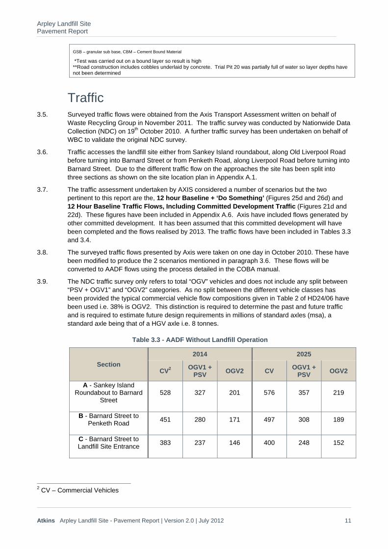
Traffic 3.5. Surveyed traffic flows were obtained from the Axis Transport Assessment written on behalf of
Waste Recycling Group in November 2011. The traffic survey was conducted by Nationwide Data Collection (NDC) on 19th October 2010. A further traffic survey has been undertaken on behalf of WBC to validate the original NDC survey.
3.6. Traffic accesses the landfill site either from Sankey Island roundabout, along Old Liverpool Road before turning into Barnard Street or from Penketh Road, along Liverpool Road before turning into Barnard Street. Due to the different traffic flow on the approaches the site has been split into three sections as shown on the site location plan in Appendix A.1.
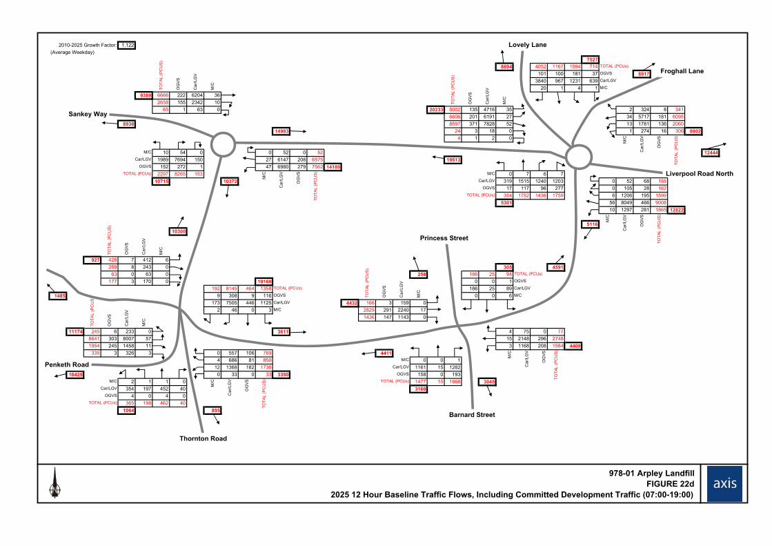
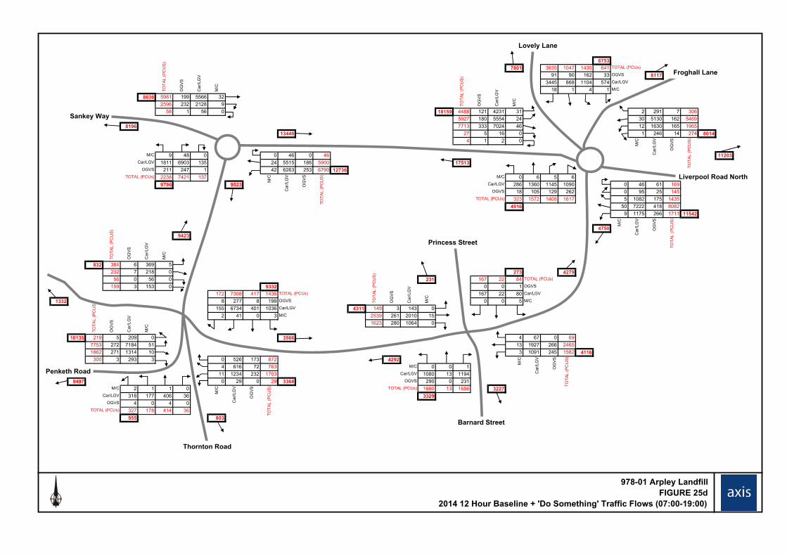
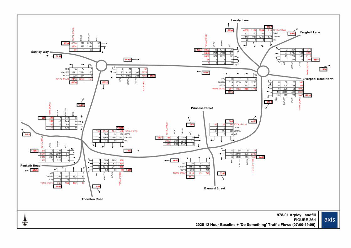
3.7. The traffic assessment undertaken by AXIS considered a number of scenarios but the two pertinent to this report are the, 12 hour Baseline + ‘Do Something’ (Figures 25d and 26d) and 12 Hour Baseline Traffic Flows, Including Committed Development Traffic (Figures 21d and 22d). These figures have been included in Appendix A.6. Axis have included flows generated by other committed development. It has been assumed that this committed development will have been completed and the flows realised by 2013. The traffic flows have been included in Tables 3.3 and 3.4.
3.8. The surveyed traffic flows presented by Axis were taken on one day in October 2010. These have been modified to produce the 2 scenarios mentioned in paragraph 3.6. These flows will be converted to AADF flows using the process detailed in the COBA manual.
3.9. The NDC traffic survey only refers to total “OGV” vehicles and does not include any split between “PSV + OGV1” and “OGV2” categories. As no split between the different vehicle classes has been provided the typical commercial vehicle flow compositions given in Table 2 of HD24/06 have been used i.e. 38% is OGV2. This distinction is required to determine the past and future traffic and is required to estimate future design requirements in millions of standard axles (msa), a standard axle being that of a HGV axle i.e. 8 tonnes.
Table 3.3 - AADF Without Landfill Operation
Section
2014 2025
CV2 OGV1 +
PSV OGV2 CV
OGV1 + PSV
OGV2
A - Sankey Island Roundabout to Barnard
Street 528 327 201 576 357 219
B - Barnard Street to Penketh Road
451 280 171 497 308 189
C - Barnard Street to Landfill Site Entrance
383 237 146 400 248 152
2 CV – Commercial Vehicles
Arpley Landfill Site Pavement Report
Atkins Arpley Landfill Site - Pavement Report | Version 2.0 | July 2012 12
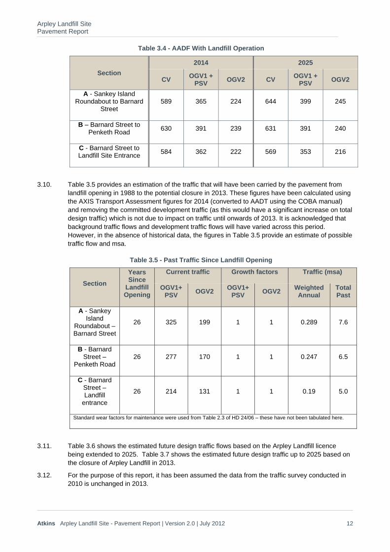
Table 3.4 - AADF With Landfill Operation
Section
2014 2025
CV OGV1 +
PSV OGV2 CV
OGV1 + PSV
OGV2
A - Sankey Island Roundabout to Barnard
Street 589 365 224 644 399 245
B – Barnard Street to Penketh Road
630 391 239 631 391 240
C - Barnard Street to Landfill Site Entrance
584 362 222 569 353 216
3.10. Table 3.5 provides an estimation of the traffic that will have been carried by the pavement from landfill opening in 1988 to the potential closure in 2013. These figures have been calculated using the AXIS Transport Assessment figures for 2014 (converted to AADT using the COBA manual) and removing the committed development traffic (as this would have a significant increase on total design traffic) which is not due to impact on traffic until onwards of 2013. It is acknowledged that background traffic flows and development traffic flows will have varied across this period. However, in the absence of historical data, the figures in Table 3.5 provide an estimate of possible traffic flow and msa.
Table 3.5 - Past Traffic Since Landfill Opening
Section
Years Since
Landfill Opening
Current traffic Growth factors Traffic (msa)
OGV1+ PSV
OGV2 OGV1+
PSV OGV2
Weighted Annual
Total Past
A - Sankey Island
Roundabout – Barnard Street
26 325 199 1 1 0.289 7.6
B - Barnard Street –
Penketh Road 26 277 170 1 1 0.247 6.5
C - Barnard Street – Landfill
entrance
26 214 131 1 1 0.19 5.0
Standard wear factors for maintenance were used from Table 2.3 of HD 24/06 – these have not been tabulated here.
3.11. Table 3.6 shows the estimated future design traffic flows based on the Arpley Landfill licence being extended to 2025. Table 3.7 shows the estimated future design traffic up to 2025 based on the closure of Arpley Landfill in 2013.
3.12. For the purpose of this report, it has been assumed the data from the traffic survey conducted in 2010 is unchanged in 2013.
Arpley Landfill Site Pavement Report
Atkins Arpley Landfill Site - Pavement Report | Version 2.0 | July 2012 13
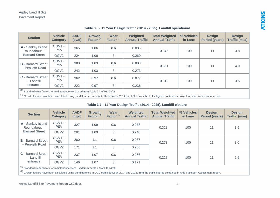
3.13. Growth factors for future traffic on each of the 3 main sections of highway have been calculated for the 2No. scenarios mentioned in section 3.6 using the differences in OGV traffic presented in Figures 21d & 22d and 25d & 26d. The past growth factor for landfill traffic has been taken as 1 as the daily intake of waste has not changed in any significance since 1988.
Arpley Landfill Site
Pavement Report
Arpley Landfill Site Pavement Report v2.0.docx 14
Table 3.6 - 11 Year Design Traffic (2014 - 2025), Landfill operational
Section Vehicle
Category AADF (cv/d)
Growth Factor (2)
Wear Factor (1)
Weighted Annual Traffic
Total Weighted Annual Traffic
% Vehicles in Lane
Design Period (years)
Design Traffic (msa)
A - Sankey Island Roundabout – Barnard Street
OGV1 + PSV 365 1.06 0.6 0.085
0.345 100 11 3.8
OGV2 224 1.06 3 0.260
B - Barnard Street – Penketh Road
OGV1 + PSV
388 1.03 0.6 0.088 0.361 100 11 4.0
OGV2 242 1.03 3 0.273
C - Barnard Street – Landfill entrance
OGV1 + PSV
362 0.97 0.6 0.077 0.313 100 11 3.5
OGV2 222 0.97 3 0.236 (1)
Standard wear factors for maintenance were used from Table 2.3 of HD 24/06 (2)
Growth factors have been calculated using the difference in OGV traffic between 2014 and 2025, from the traffic figures contained in Axis Transport Assessment report.
Table 3.7 - 11 Year Design Traffic (2014 - 2025), Landfill closure
Section Vehicle
Category AADF (cv/d)
Growth Factor (2)
Wear Factor (1)
Weighted Annual Traffic
Total Weighted Annual Traffic
% Vehicles in Lane
Design Period (years)
Design Traffic (msa)
A - Sankey Island Roundabout – Barnard Street
OGV1 + PSV 327 1.09 0.6 0.078
0.318 100 11 3.5 OGV2 201 1.09 3 0.240
B - Barnard Street – Penketh Road
OGV1 + PSV
280 1.1 0.6 0.067 0.273 100 11 3.0
OGV2 171 1.1 3 0.206
C - Barnard Street – Landfill entrance
OGV1 + PSV
237 1.07 0.6 0.056 0.227 100 11 2.5
OGV2 146 1.07 3 0.171 (1)
Standard wear factors for maintenance were used from Table 2.3 of HD 24/06 (2)
Growth factors have been calculated using the difference in OGV traffic between 2014 and 2025, from the traffic figures contained in Axis Transport Assessment report.

Arpley Landfill Site Pavement Report
Atkins Arpley Landfill Site - Pavement Report | Version 2.0 | July 2012 15
3.14. Table 3.8 shows the total design traffic in million standard axles (msa), calculated above, from 1988 to 2025 for both scenarios.
Table 3.8 - 37 Year Design Traffic (1988 - 2025)
Section Scenario Design Traffic
Total Design Traffic
1988 – 2014 (msa)
2014 – 2025 (msa)
1988 – 2025 (msa)
A - Sankey Island – Barnard Street
Landfill remains operational
7.6 3.8 11.4
Landfill closure 7.6 3.5 11.1
B - Barnard Street – Penketh Road
Landfill remains operational
6.5 4.0 10.5
Landfill closure 6.5 3.0 9.5
C - Barnard Street – Landfill entrance
Landfill remains operational
5.0 3.5 8.5
Landfill closure 5.0 2.5 7.5
3.15. Design traffic is calculated by adding the traffic from the past 26 years to the projected traffic for the next 11 years. Past traffic is used in order to make allowance for traffic induced damage that has taken place since the landfill became operational. Accordingly, the 37 year (1988 to 2025) design traffic, using the worst case (Sankey Island Roundabout to Barnard Street with the landfill remaining in operation until 2025) is 11.4msa.
3.16. If the landfill were to close in 2013, the worst case total design traffic from 1988 to 2025 would be 11.1msa (Sankey Island Roundabout to Barnard Street). This shows no significant difference in total design traffic between the two scenarios, when considering the worst case. Barnard Street to Penketh Road and Barnard Street to the Landfill Entrance both show a difference in design traffic of 1msa between the two scenarios.
3.17. If the landfill was to be granted an extension to its licence the worst case increase in traffic loading is 0.3msa. This will have a minimal impact on the required pavement construction thicknesses.
3.18. The historical weighbridge data back up the minimal impact loading from landfill traffic has had on the highway network. Weighbridge data was only available between 2001 and 2010. Over this period 0.8msa accessed the site. This correlates with the levels of traffic that have been calculated later in this report.
3.19. The data collated by Atkins further supports this finding. Traffic count data collected on Forrest Way only included vehicles that were entering the waste facility. This traffic was extrapolated, in a similar manner to earlier in this section, for the next 11 years of use and equated to 1.3msa.
Arpley Landfill Site Pavement Report
Atkins Arpley Landfill Site - Pavement Report | Version 2.0 | July 2012 16
Standard Design 3.20. An average Calafornian Bearing Ratio (CBR) of 8% has been derived from the values contained in
Table 3.2. The upper bound values have been disregarded to produce this average. Based on the values contained in Interim Advice Note (IAN) 73/06 this would require 270mm of Type 1 to achieve a Class 2 foundation or 230mm of bound sub base to achieve a Class 3 foundation.
3.21. Eight of the trial pits showed that the pavement has a bound foundation. In these locations none were recorded as having a depth of 230mm but all of the Cement Bound Material (CBM) appeared to be in good condition and providing a sound foundation. With a Class 3 foundation a standard fully flexible design for 11msa (using HD26/06) would comprise 250mm of DBM50 asphalt. Only one of the trial pits has a greater depth of asphalt than this.
3.22. The remainder of the pavement has an unbound foundation. Only one of these pits contained pavement with greater than 270mm of type 1 sub base. With a class 2 foundation a standard fully flexible design for 11msa (using HD26/06) would comprise 280mm DBM50 asphalt. Several locations have depths of asphalt greater than this but most of the locations have thinner asphalt construction.
Arpley Landfill Site Pavement Report
Atkins Arpley Landfill Site - Pavement Report | Version 2.0 | July 2012 17
4. Assessment of Current Condition 4.1. Although the pavement does not meet the minimum design criteria of HD26 for all locations the
general assessment of the condition is that the pavement foundation and lower bound layers, consisting of both asphalt and cement, are performing well.
4.2. The deterioration of the pavement would appear to be limited to life expired materials contained in the upper asphalt layers. Particularly the surface course, predominately consisting of HRA, which is experiencing some level of deterioration throughout the roads considered.
4.3. Several trenches which have been reinstated, after New Road Works and Street Works Act works, have failed or have open joints throughout the scheme. These areas of weakness provide a potential path for water to penetrate lower pavement layers and exacerbate their deterioration.
4.4. Invasive pavement investigation has only been conducted on Liverpool Road to the west of Barnard Street. The VCS showed this area of carriageway to be the most deteriorated. Inspection of the remainder of the highway under consideration showed that it is generally in good condition with localised defects as discussed above.
4.5. The rutting and cracking recorded is likely to be confined to upper layers of the pavement. This will be clarified during future resurfacing works after exposure of the binder course. Additionally, failure of the trench reinstatements may be leading to reflective cracking appearing at the surface of the pavement. This will also be clarified after removal of the surface course.
4.6. The continued use of this highway by traffic using both the surrounding highway network and the landfill site will lead to the further deterioration of the pavement surface.
4.7. The traffic analysis in section 3 of this report showed that for the section of highway between Penketh Road and the site entrance the continued operation of the landfill will add approximately 1msa to the pavement between 2014 to 2025. Between 2014 and 2025 the additional traffic from the landfill will equate to a 40% increase in loading on this section of highway.
Arpley Landfill Site Pavement Report
Atkins Arpley Landfill Site - Pavement Report | Version 2.0 | July 2012 18
5. Treatment Design Constraints
5.1. The following factors will influence the selection of an appropriate maintenance treatment for this site.
Finished road level 5.2. The access roads discussed throughout this report are all located within an urban environment.
The road levels are constrained by a number of factors including kerbs, drainage infrastructure, junctions and bridge structures. It would not be possible to alter the levels of the existing carriageway without extensive work being carried out.
5.3. There are 4No. bridge structures within the scheme limits.
Drainage 5.4. Each section of road is drained by kerb and gullies. Although there did not appear to be any sign
of blockage, a number of gullies on each section of road have sunk as shown in the photographs contained in Appendix A.2.
Network Disruption 5.5. All roads under consideration are single 2 carriageway (SU2) through an urban area. The
proposed traffic management to undertake any pavement works would be temporary traffic lights. There are a large number of junctions and direct residential access along Liverpool Road, therefore the layout and phasing of the works would have to be carefully planned. Any diversion route put in place would cause significant disruption to local traffic.
Hazardous materials 5.6. No laboratory testing has been undertaken to confirm the presence (or otherwise) of hazardous
materials such as tar. Representative sampling of the treatment layers would be required before work commences to determine if any TAR bound materials are present within the existing construction as special disposal of this material would be required.
Maintenance History 5.7. The maintenance history for each access road is unknown.
Buried services 5.8. No STATS searches have been undertaken as part of this study. There is however a significant
number of trenches on each surveyed road, in particular from Barnard Street to Penketh Road. As the highways are located in an urban environment it is anticipated that there are a large number of services crossing the roads.
Arpley Landfill Site Pavement Report
Atkins Arpley Landfill Site - Pavement Report | Version 2.0 | July 2012 19
Options 5.9. Based on the survey information, the majority of existing pavement appears to be in reasonable
condition, excluding the far western end of Liverpool Road. This stretch of road has a large number of cracks and previous repair patches. Throughout the remainder of the access roads there are a number of sunken ironworks, the surface appears worn and has little texture depth. There are also localised areas which show significant defects which will require an inlay to rectify the issues.
5.10. The future committed development and the continued operation of the landfill will accelerate the deterioration of the pavement. Therefore, the early treatment of these defects will help reduce the amount of future deterioration and lengthen the life of the pavement.
5.11. Although the foundation and lower layers appear to be functioning and providing adequate support for the pavement the upper layers are showing extensive signs of deterioration.
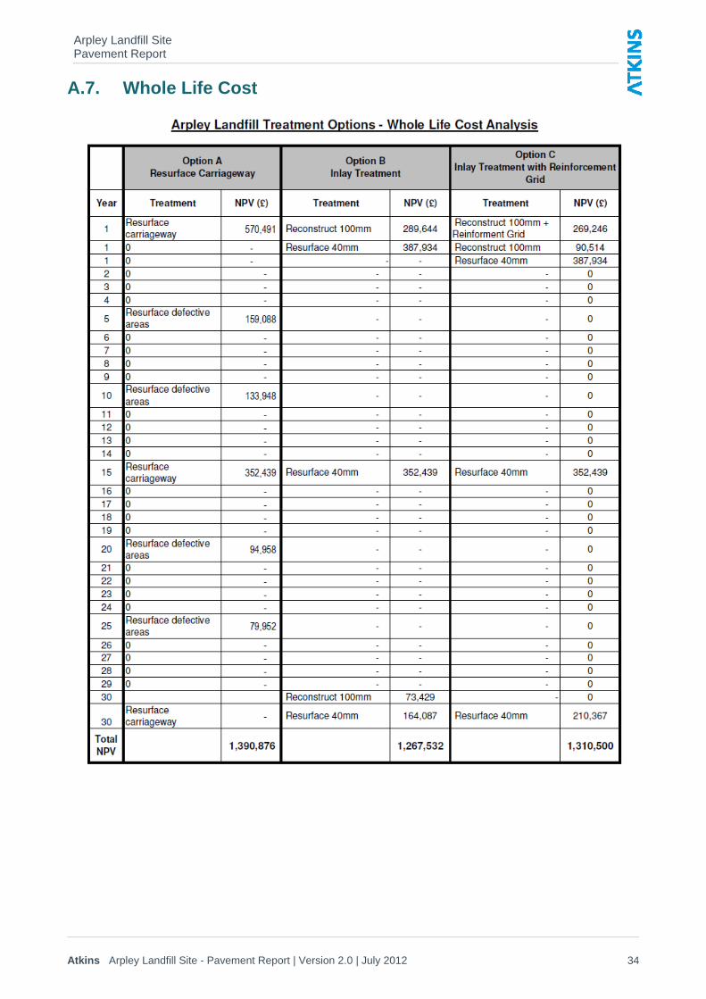
5.12. The following treatment options have been considered for this site. A whole life cost associated with each option has been included in Appendix A.7.
“Do nothing” 5.13. The age and general wear of the existing HRA would suggest that a “Do nothing” approach is not
appropriate for this site.
“Replace Surface” 5.14. Replacing the road surface throughout would remove the existing potholes, cracks and areas of
rutting. This would provide a level running surface, which will reduce noise from traffic. Resurfacing will prevent the ingress of water, which may stabilise the pavement condition and prolong its life albeit, perhaps only for a short time. This would involve planning off and relaying approximately 40mm of surface course along the full length of the roads under consideration. All sunken ironworks along each of the access roads would be reset to the correct level.
“Inlay Treatment” 5.15. A surface inlay treatment is considered appropriate for the areas showing significant defects and
will provide a pavement structure capable of carrying the predicted future traffic. It will also restore the surface characteristics to an acceptable level for the type of road.
5.16. This would involve removing the upper 100mm of road construction in areas of carriageway which are displaying multiple defects including surface rutting and cracking. The deeper inlay would comprise 60mm of binder course and 40mm surface course. All sunken ironworks in the area would be reset to the correct level.
“Inlay Treatment with Reinforcement Grid” 5.17. This treatment area would include the same extents of 100mm inlay as the option described in the
previous section. In addition to the inlay an asphalt reinforcement grid would be placed targeted at the areas showing significant defects. This would delay reflective cracking from old trenches and defects in the layers below appearing at the surface. It will also strengthen the pavement and increase the time it will take the road to rut, providing the pavement with a longer life.
5.18. This would involve placing an asphalt reinforcing grid at the base of the proposed binder course to prevent damage during future resurfacing works. All sunken ironworks in the area would be reset to the correct level.
Arpley Landfill Site Pavement Report
Atkins Arpley Landfill Site - Pavement Report | Version 2.0 | July 2012 20
Recommendation 5.19. Based on the information discussed above, it is recommended that an inlay treatment is provided
in those areas showing significant defects whilst the remainder of the carriageway is resurfaced. As the continued operation of the landfill will significantly increase the loading of the pavements considered in this report, it is recommended that the remedial works are completed prior to the extension of the landfill operation.
5.20. The whole life cost calculations show that this option is the most cost effective as the additional costs of a reinforcing grid are avoided but the failing areas of surface will be sufficiently treated to reduce future surfacing works. However, it should be noted that there is little cost difference between the three options as shown in the summary sheet in Appendix A7.
5.21. Based on the visual condition of the road and the construction depths from the trial hole data (Table 3.2) there appear to be no major underlying issues. It is recommended that deflection testing is undertaken along with a new batch of core samples to support the conclusion in this report. These core samples should be taken at regular intervals along the other roads under consideration to confirm their construction.
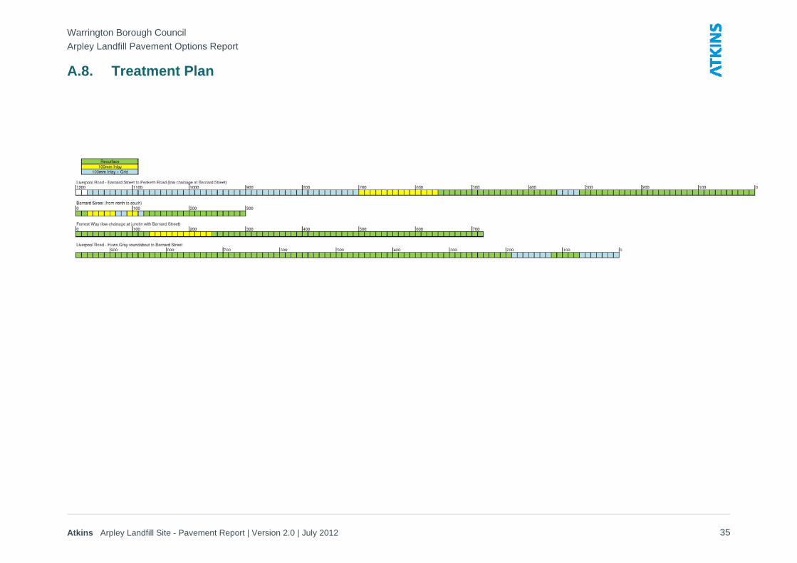
5.22. The areas of recommended treatment are shown on the strip plan in Appendix A8. The extent of works is summarised in Table 5.1. The 100mm inlay with reinforcing grid is recommended for Liverpool Road to the east and west of Barnard Street and short sections on Barnard Street itself.
Table 5.1 – Extent of Recommended Treatment
Recommended Works Distance (metres)
Resurfacing 1430m
100mm Inlay 320m
100mm Inlay with reinforcing grid 690m

Appendices
Arpley Landfill Site Pavement Report
Atkins Arpley Landfill Site - Pavement Report | Version 2.0 | July 2012 22
A.1. Site Location Plan
Arpley Landfill Local Access Roads
Arpley Landfill Site Pavement Report
Atkins Arpley Landfill Site - Pavement Report | Version 2.0 | July 2012 23
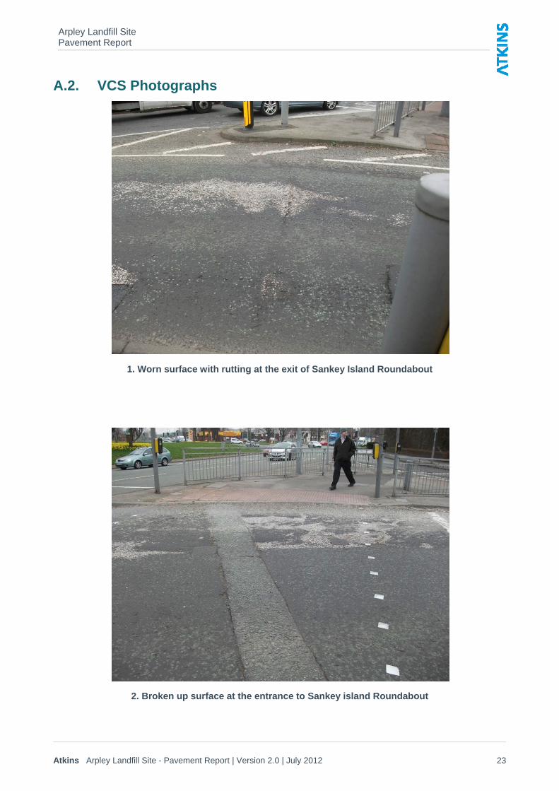
A.2. VCS Photographs
1. Worn surface with rutting at the exit of Sankey Island Roundabout
2. Broken up surface at the entrance to Sankey island Roundabout
Arpley Landfill Site Pavement Report
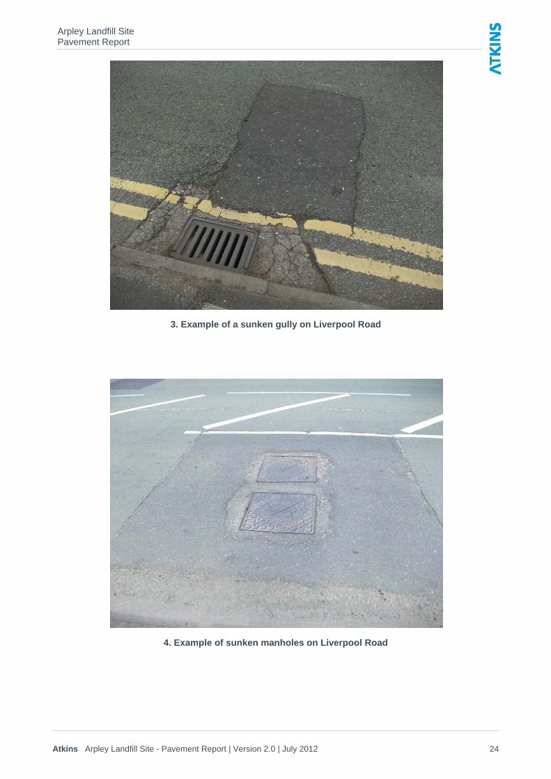
Atkins Arpley Landfill Site - Pavement Report | Version 2.0 | July 2012 24
3. Example of a sunken gully on Liverpool Road
4. Example of sunken manholes on Liverpool Road
Arpley Landfill Site Pavement Report
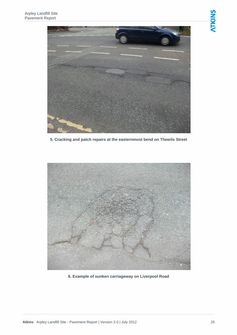
Atkins Arpley Landfill Site - Pavement Report | Version 2.0 | July 2012 25
5. Cracking and patch repairs at the easternmost bend on Thewils Street
6. Example of sunken carriageway on Liverpool Road
Arpley Landfill Site Pavement Report
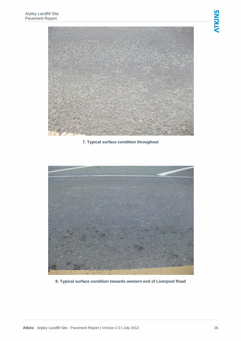
Atkins Arpley Landfill Site - Pavement Report | Version 2.0 | July 2012 26
7. Typical surface condition throughout
8. Typical surface condition towards western end of Liverpool Road
Arpley Landfill Site Pavement Report
Atkins Arpley Landfill Site - Pavement Report | Version 2.0 | July 2012 27
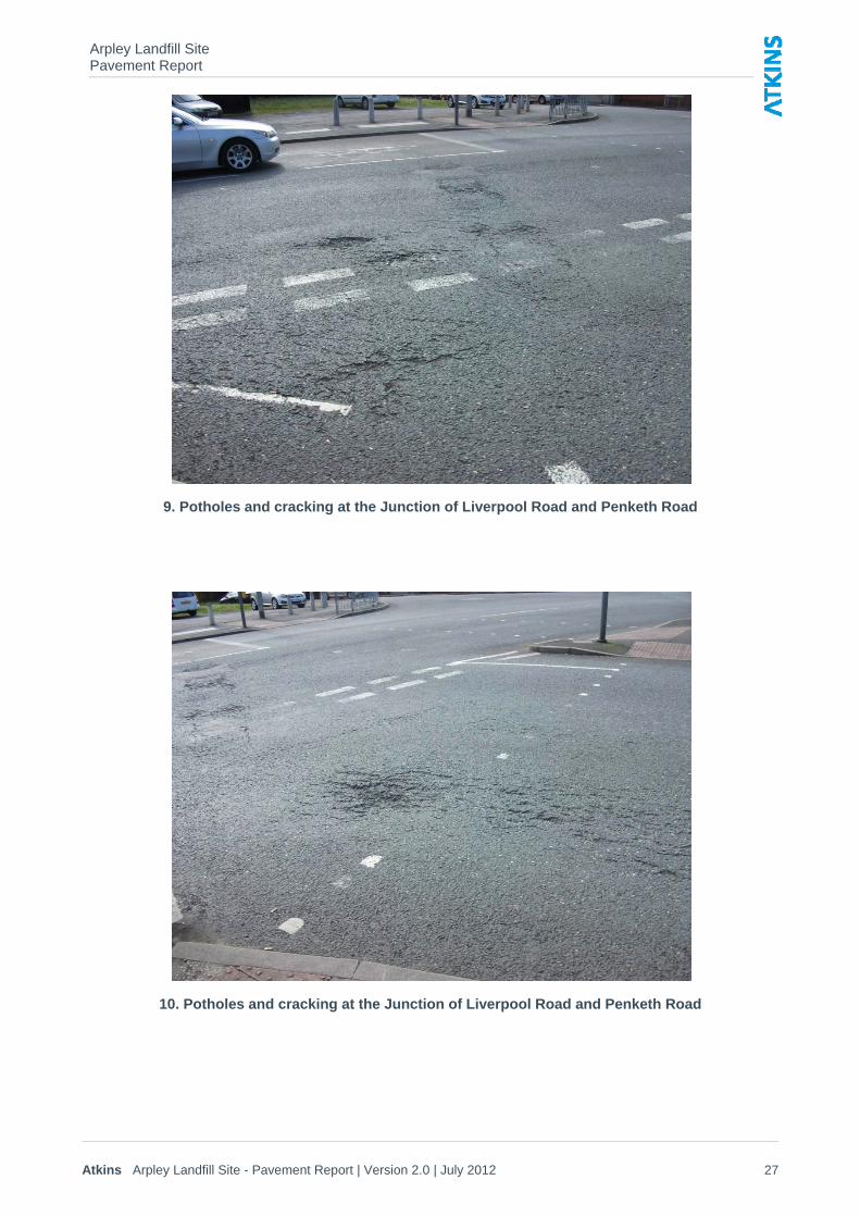
9. Potholes and cracking at the Junction of Liverpool Road and Penketh Road
10. Potholes and cracking at the Junction of Liverpool Road and Penketh Road
Arpley Landfill Site Pavement Report
Atkins Arpley Landfill Site - Pavement Report | Version 2.0 | July 2012 28
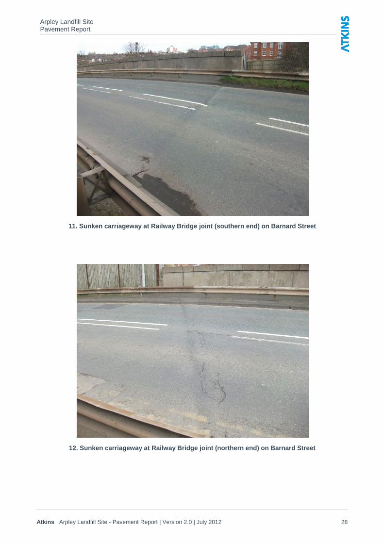
11. Sunken carriageway at Railway Bridge joint (southern end) on Barnard Street
12. Sunken carriageway at Railway Bridge joint (northern end) on Barnard Street
Arpley Landfill Site Pavement Report
Atkins Arpley Landfill Site - Pavement Report | Version 2.0 | July 2012 29
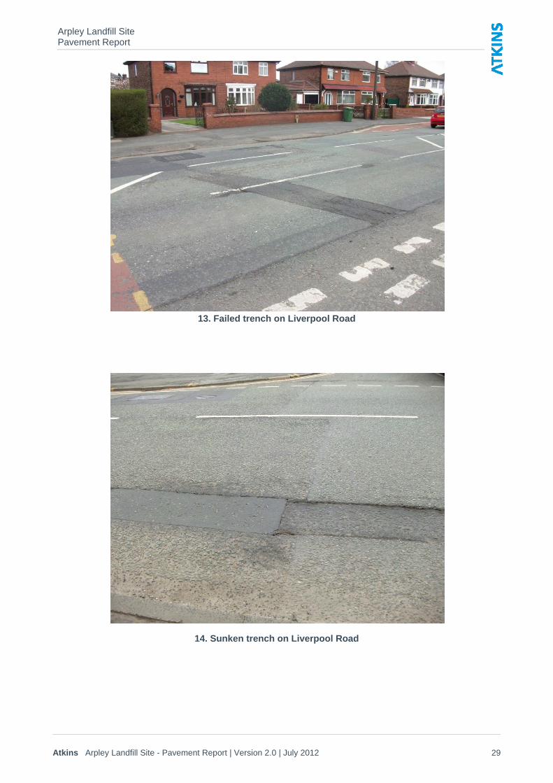
13. Failed trench on Liverpool Road
14. Sunken trench on Liverpool Road
Arpley Landfill Site Pavement Report
Atkins Arpley Landfill Site - Pavement Report | Version 2.0 | July 2012 30
A.3. VCS Plans


Arpley Landfill Site Pavement Report
Atkins Arpley Landfill Site - Pavement Report | Version 2.0 | July 2012 31
A.4. Core Samples Location Plan
Scales
Drawing No.
Date:Revision DetailsRevn. Chk byRev by
Phase / Revision
AutoCAD File Ref:
Project
Drawing Title
Drawn by
Approved by Telephone
Fax Sheet ofDate 01925 44
NOTES
01925 44
Liverpool Road.dwg
Environment and Regeneration DirectorateTransportation Service, Palmyra House, Palmyra Square North, Warrington WA1 1JN
Liverpool Road, Sankey Bridges
Road CoresLocation Plan
H08-000/00/01NTSNTS
1 1
SCD
Aug2008
2533
3255Based on Ordnance Survey mapping with thepermission of The Controller of Her Majesty'sStationery Office Crown copyright.Unauthorised reproduction infringes Crown copyrightand may lead to prosecution or civil proceedings.Warrington Borough Council Licence no. 100022848.Published 2008.
NB Positions for cores will be identified priorto commencement on site (approx. 30no.Cores)
Approximate position of core
C15B
C15AC14B
C14A C13B
C13A C12B
C12A C11B
C11A C10B
C10A C9B
C9AC8B
C8AC7B
C7A
C6B
C6A
C5B
C5A C4B
C4AC3B
C3A
C2B
C2A
C1BC1A
Arpley Landfill Site Pavement Report
Atkins Arpley Landfill Site - Pavement Report | Version 2.0 | July 2012 32
A.5. Trial Pit Location Plan
CU
T LI
NE
CU
T LI
NE
Scales
Drawing No.
Date:Revision DetailsRevn. Chk byRev by
Phase / Revision
AutoCAD File Ref:
Project
Drawing Title
Drawn by
Approved by Telephone
Fax Sheet ofDate 01925 44
NOTES
01925 44
Trial Pits.dwg
Transportation, Engineering and Climate Change
New Town House, Buttermarket Street, Warrington WA1 2NH
Environment and Regeneration Directorate
gtBorough Council
Liverpool Road, Sankey BridgesTrial Pits
Locations and Results
H10-M01/002 D/A1:1000
1 1
Clive Arnold
25.01.11
2698
3255
Based on Ordnance Survey mapping with thepermission of The Controller of Her Majesty'sStationery Office Crown copyright.Unauthorised reproduction infringes Crown copyrightand may lead to prosecution or civil proceedings.Warrington Borough Council Licence no. 100022848.Published 2011.
TP1
TP3
TP4
TP2
TP5TP6
TP7
TP8
TP9
TP10
TP11TP12
TP14TP13
TP16TP15
TP17
TP18 TP20
TP19
6.8
>100
7.1
>100
34
7.7
24
55
3.8
7.2
9.9
5.8
8.6
8.1
36
5.2
9.7
no test
14
13
14
12
1
2
15
16
3
4
17
18
6
19
7
11
8
10
9
52.9
Bitumen bound layers 200mm
Bitumen bound layers 260mm
Bitumen bound layers 230mm
Bitumen bound layers 200mm
Bitumen bound layers 310mm
3
Bitumen bound layers 230mm
Bitumen bound layers 215mm
Bitumen bound layers 250mm
Bitumen bound layers 200mm
Bitumen bound layers 110mm
Bitumen bound layers 150mmBitumen bound layers 150mm
Bitumen bound layers 170mm
Bitumen bound layers 200mm
Bitumen bound layers 180mm
Bitumen bound layers 130mm
Bitumen bound layers 260mm
Bitumen bound layers 180mm
Bitumen bound layers 325mm
Bitumen bound layers 300mm
SettsSetts
Setts
Concrete
Trial pit locations shown:
% CBR result shown:
See trial pit descriptions also.
TP1
14 7 Test ref no.
Arpley Landfill Site Pavement Report
Atkins Arpley Landfill Site - Pavement Report | Version 2.0 | July 2012 33
A.6. Traffic Figures
2010-2014 Growth Factor: 1.006
(Average Weekday)
6753
7801 3635 1047 1430 641 TOTAL (PCUs)
91 90 162 33 OGVS 8043
3445 868 1104 574 Car/LGV
18 1 4 1 M/C
8457 5981 199 5566 32
2417 144 2125 9
58 1 56 0 18153 4488 121 4231 31 2 291 7 306
5927 180 5554 24 30 5130 162 5469
8051 7713 333 7024 46 12 1629 128 1891
13443 21 3 16 0 1 246 14 274 7940
4 1 2 0
M/C 9 48 0 0 46 0 46 11180
Car/LGV 1808 6903 135 24 5515 186 5900 17508
OGVS 140 244 1 42 6263 250 6784 12730
TOTAL (PCUs) 2094 7415 137 M/C 0 6 5 6
9646 9338 Car/LGV 286 1360 1144 1090 0 46 61 169
OGVS 16 105 92 250 0 95 25 145
TOTAL (PCUs) 317 1572 1331 1594 5 1082 175 1435
4814 50 7222 418 8082
9 1175 255 1688 11519
4648
9273
832 384 6 369 5
232 7 218 0 273 4177
56 0 56 0 231 167 22 84 TOTAL (PCUs)
159 3 153 0 9148 0 0 1 OGVS
172 7308 417 1251 TOTAL (PCUs) 167 22 80 Car/LGV
1332 8 277 8 108 OGVS 0 0 5 M/C
155 6734 401 1033 Car/LGV 4023 149 3 143 0
2 41 0 3 M/C 2539 261 2010 15
1335 138 1059 0
10031 219 5 209 0 3278 4 67 0 69
7753 272 7184 51 13 1927 266 2465
1758 220 1313 10 3 1089 194 1479 4014
300 3 293 3 0 523 100 723 4004
4 616 72 763 M/C 0 0 1
11 1232 164 1565 Car/LGV 1075 13 1192
9359 0 29 0 29 3080 OGVS 148 0 181
M/C 2 1 1 0 TOTAL (PCUs) 1372 13 1554 2837
Car/LGV 318 177 406 36 2939
OGVS 4 0 4 0
TOTAL (PCUs) 327 178 414 36
955 803
TOTAL (PCUS)
TOTAL (PCUS)
TOTAL (PCUS)
TOTAL (PCUS)
M/C
Car/LGV
OGVS
OGVS
M/C
Car/LGV
TOTAL (PCUS)
OGVS
Car/LGV
TOTAL (PCUS)
TOTAL (PCUS)
M/C
M/C
M/C
M/C
OGVS
Car/LGV
OGVS
Car/LGV
Car/LGV
TOTAL (PCUS)
TOTAL (PCUS)
OGVS
TOTAL (PCUS)
M/C
Car/LGV
M/C
OGVS
OGVS
Car/LGV
M/C
M/C
Car/LGV
OGVS
OGVS
Car/LGV
978-01 Arpley Landfill
FIGURE 21d
2014 12 Hour Baseline Traffic Flows, Including Committed Development Traffic (07:00-19:00)
Princess Street
Sankey Way
Thornton Road
Penketh Road
Barnard Street
Lovely Lane
Froghall Lane
Liverpool Road North
2010-2025 Growth Factor: 1.122
(Average Weekday)
7527
8694 4052 1167 1594 714 TOTAL (PCUs)
101 100 181 37 OGVS 8917
3840 967 1231 639 Car/LGV
20 1 4 1 M/C
9389 6666 222 6204 36
2658 155 2342 10
65 1 63 0 20233 5002 135 4716 35 2 324 8 341
6606 201 6191 27 34 5717 181 6095
8938 8597 371 7828 52 13 1781 136 2060
14983 24 3 18 0 1 274 16 306 8802
4 1 2 0
M/C 10 54 0 0 52 0 52 12444
Car/LGV 1989 7694 150 27 6147 208 6575 19513
OGVS 152 272 1 47 6980 279 7562 14189
TOTAL (PCUs) 2297 8265 153 M/C 0 7 6 7
10715 10372 Car/LGV 319 1515 1240 1203 0 52 68 188
OGVS 17 117 96 277 0 105 28 162
TOTAL (PCUs) 354 1752 1436 1759 6 1206 195 1599
5301 56 8049 466 9008
10 1297 281 1865 12822
5116
10300
927 428 7 412 6
259 8 243 0 305 4591
63 0 63 0 258 186 25 94 TOTAL (PCUs)
177 3 170 0 10160 0 0 1 OGVS
192 8145 464 1358 TOTAL (PCUs) 186 25 89 Car/LGV
1485 9 308 9 116 OGVS 0 0 6 M/C
173 7505 446 1125 Car/LGV 4432 166 3 159 0
2 46 0 3 M/C 2829 291 2240 17
1436 147 1143 0
11174 245 6 233 0 3611 4 75 0 77
8641 303 8007 57 15 2148 296 2748
1954 245 1458 11 3 1168 208 1584 4409
335 3 326 3 0 557 106 769 4411
4 686 81 850 M/C 0 0 1
12 1368 182 1738 Car/LGV 1161 15 1282
10425 0 33 0 33 3390 OGVS 158 0 193
M/C 2 1 1 0 TOTAL (PCUs) 1477 15 1668 3045
Car/LGV 354 197 452 40 3160
OGVS 4 0 4 0
TOTAL (PCUs) 365 198 462 40
1064 895
OGVS
OGVS
Car/LGV
M/C
M/C
Car/LGV
OGVS
OGVS
Car/LGV
TOTAL (PCUS)
TOTAL (PCUS)
OGVS
TOTAL (PCUS)
M/C
Car/LGV
M/C
TOTAL (PCUS)
M/C
M/C
M/C
M/C
OGVS
Car/LGV
OGVS
Car/LGV
Car/LGV
TOTAL (PCUS)
OGVS
Car/LGV
TOTAL (PCUS)
TOTAL (PCUS)
TOTAL (PCUS)
TOTAL (PCUS)
TOTAL (PCUS)
M/C
Car/LGV
OGVS
OGVS
M/C
Car/LGV
978-01 Arpley Landfill
FIGURE 22d
2025 12 Hour Baseline Traffic Flows, Including Committed Development Traffic (07:00-19:00)
Princess Street
Sankey Way
Thornton Road
Penketh Road
Barnard Street
Lovely Lane
Froghall Lane
Liverpool Road North
6753
7801 3635 1047 1430 641 TOTAL (PCUs)
91 90 162 33 OGVS 8117
3445 868 1104 574 Car/LGV
18 1 4 1 M/C
8636 5981 199 5566 32
2596 232 2128 9
58 1 56 0 18159 4488 121 4231 31 2 291 7 306
5927 180 5554 24 30 5130 162 5469
8196 7713 333 7024 46 12 1630 165 1965
13448 27 5 16 0 1 246 14 274 8014
4 1 2 0
M/C 9 48 0 0 46 0 46 11203
Car/LGV 1811 6903 135 24 5515 186 5900 17513
OGVS 211 247 1 42 6263 253 6790 12736
TOTAL (PCUs) 2238 7421 137 M/C 0 6 5 6
9796 9523 Car/LGV 286 1360 1145 1090 0 46 61 169
OGVS 18 105 129 262 0 95 25 145
TOTAL (PCUs) 323 1572 1405 1617 5 1082 175 1435
4916 50 7222 418 8082
9 1175 266 1711 11542
4750
9423
832 384 6 369 5
232 7 218 0 273 4279
56 0 56 0 231 167 22 84 TOTAL (PCUs)
159 3 153 0 9332 0 0 1 OGVS
172 7308 417 1436 TOTAL (PCUs) 167 22 80 Car/LGV
1332 8 277 8 199 OGVS 0 0 5 M/C
155 6734 401 1036 Car/LGV 4311 149 3 143 0
2 41 0 3 M/C 2539 261 2010 15
1623 280 1064 0
10135 219 5 209 0 3566 4 67 0 69
7753 272 7184 51 13 1927 266 2465
1862 271 1314 10 3 1091 245 1582 4116
300 3 293 3 0 526 173 872 4292
4 616 72 763 M/C 0 0 1
11 1234 232 1703 Car/LGV 1080 13 1194
9497 0 29 0 29 3368 OGVS 290 0 231
M/C 2 1 1 0 TOTAL (PCUs) 1660 13 1656 3227
Car/LGV 318 177 406 36 3329
OGVS 4 0 4 0
TOTAL (PCUs) 327 178 414 36
955 803
OGVS
OGVS
Car/LGV
M/C
M/C
Car/LGV
OGVS
OGVS
Car/LGV
TOTAL (PCUS)
TOTAL (PCUS)
OGVS
TOTAL (PCUS)
M/C
Car/LGV
M/C
TOTAL (PCUS)
M/C
M/C
M/C
M/C
OGVS
Car/LGV
OGVS
Car/LGV
Car/LGV
TOTAL (PCUS)
OGVS
Car/LGV
TOTAL (PCUS)
TOTAL (PCUS)
TOTAL (PCUS)
TOTAL (PCUS)
TOTAL (PCUS)
M/C
Car/LGV
OGVS
OGVS
M/C
Car/LGV
978-01 Arpley Landfill
FIGURE 25d
2014 12 Hour Baseline + 'Do Something' Traffic Flows (07:00-19:00)
Princess Street
Sankey Way
Thornton Road
Penketh Road
Barnard Street
Lovely Lane
Froghall Lane
Liverpool Road North
7527
8694 4052 1167 1594 714 TOTAL (PCUs)
101 100 181 37 OGVS 8970
3840 967 1231 639 Car/LGV
20 1 4 1 M/C
9536 6666 222 6204 36
2804 227 2344 10
65 1 63 0 20237 5002 135 4716 35 2 324 8 341
6606 201 6191 27 34 5717 181 6095
9054 8597 371 7828 52 13 1782 162 2113
14987 28 5 18 0 1 274 16 306 8855
4 1 2 0
M/C 10 54 0 0 52 0 52 12460
Car/LGV 1991 7694 150 27 6147 208 6575 19517
OGVS 208 274 1 47 6980 281 7565 14192
TOTAL (PCUs) 2413 8269 153 M/C 0 7 6 7
10834 10522 Car/LGV 319 1515 1241 1203 0 52 68 188
OGVS 19 117 122 284 0 105 28 162
TOTAL (PCUs) 357 1752 1488 1775 6 1206 195 1599
5373 56 8049 466 9008
10 1297 289 1880 12838
5188
10419
927 428 7 412 6
259 8 243 0 305 4663
63 0 63 0 258 186 25 94 TOTAL (PCUs)
177 3 170 0 10310 0 0 1 OGVS
192 8145 464 1508 TOTAL (PCUs) 186 25 89 Car/LGV
1485 9 308 9 190 OGVS 0 0 6 M/C
173 7505 446 1127 Car/LGV 4671 166 3 159 0
2 46 0 3 M/C 2829 291 2240 17
1675 264 1147 0
11263 245 6 233 0 3850 4 75 0 77
8641 303 8007 57 15 2148 296 2748
2043 289 1460 11 3 1169 243 1656 4481
335 3 326 3 0 559 165 889 4650
4 686 81 850 M/C 0 0 1
12 1370 241 1858 Car/LGV 1165 15 1283
10545 0 33 0 33 3629 OGVS 276 0 228
M/C 2 1 1 0 TOTAL (PCUs) 1716 15 1740 3356
Car/LGV 354 197 452 40 3471
OGVS 4 0 4 0
TOTAL (PCUs) 365 198 462 40
1064 895
TOTAL (PCUS)
TOTAL (PCUS)
TOTAL (PCUS)
TOTAL (PCUS)
M/C
Car/LGV
OGVS
OGVS
M/C
Car/LGV
TOTAL (PCUS)
OGVS
Car/LGV
TOTAL (PCUS)
TOTAL (PCUS)
M/C
M/C
M/C
M/C
OGVS
Car/LGV
OGVS
Car/LGV
Car/LGV
TOTAL (PCUS)
TOTAL (PCUS)
OGVS
TOTAL (PCUS)
M/C
Car/LGV
M/C
OGVS
OGVS
Car/LGV
M/C
M/C
Car/LGV
OGVS
OGVS
Car/LGV
978-01 Arpley Landfill
FIGURE 26d
2025 12 Hour Baseline + 'Do Something' Traffic Flows (07:00-19:00)
Princess Street
Sankey Way
Thornton Road
Penketh Road
Barnard Street
Lovely Lane
Froghall Lane
Liverpool Road North
Arpley Landfill Site Pavement Report
Atkins Arpley Landfill Site - Pavement Report | Version 2.0 | July 2012 34
A.7. Whole Life Cost
Warrington Borough Council
Arpley Landfill Pavement Options Report
Atkins Arpley Landfill Site - Pavement Report | Version 2.0 | July 2012 35
A.8. Treatment Plan

© Atkins Ltd except where stated otherwise. The Atkins logo, ‘Carbon Critical Design’ and the strapline ‘Plan Design Enable’ are trademarks of Atkins Ltd.
John Grayston Atkins Chadwick House Birchwood WA3 6AE
[email protected] 01925 238328
Planning Support – Arpley Landfill Application 2011/19244
Final Report
31st May 2012
Warrington Borough Council
Arpley Landfill
2
Date Details Prepared by Reviewed and approved by
11/05/12 Draft Report Alethea Evans, Senior Planner
John Martin, Principal Planner
25/05/12 Final Report Alethea Evans, Senior Planner
John Martin, Principal Planner
CONTENTS
Executive Summary 5
1. Introduction 7
2. Site Description and Surroundings 7
3. Relevant Site History 8
4. Details of Proposal 9
5. Appraisal of wider landfill capacity and the need for the proposed
extension of time at Arpley 10
Assessment of current landfill capacity in Warrington and future landfill
requirements for managing Warrington’s waste 10
Appraisal of wider need for the development 16
Merseyside and Halton Joint Waste Plan 17
Greater Manchester Waste Plan 19
Cheshire East and Cheshire West and Chester 19
Assessment of Need Summary 20
6. Assessment of re-profiling proposals, landfill design, phasing and
restoration 20
Re-profiling 21
Landfill Design 22
Phasing and Restoration 22
7. Appraisal of the proposal against national, regional and local waste
planning policy 23
National Planning Policy 24
Regional Planning Policy 26
Local Policies 29
Policy Assessment Summary 33
4
Glossary of Abbreviations
AOD Above Ordinance Datum
CHP Combined Heat and Power
EfW Energy from Waste
ES Environment Statement
LACW Local Authority Collected Waste
MBT Mechanical Biological Treatment
MWMS Municipal Waste Management Strategy
NPPF National Planning Policy Statement
PPS10 Planning Policy Statement 10
RSS Regional Spatial Strategy
RWS Regional Waste Strategy
UDP Unitary Development Plan
WBC Warrington Borough Council
WNA Warrington Needs Assessment
WPA Waste Planning Authority
WSE2007 Waste Strategy for England 2007
5
Arpley Landfill Final Report
Executive Summary Warrington is currently largely self-sufficient with regards to landfill. The Warrington
Needs Assessment identifies that in order to maintain self sufficiency if Arpley
landfill, the subject of this report, closes in 2013, an alternative landfill site would
need to be found within Warrington. However, Regional Spatial Strategy Policy
EM13 supports the continued use of existing landfill facilities in preference to new
sites. If no alternative sites become available within Warrington then the waste
would have to be exported out of the district. This would place additional pressure
upon Gowy landfill (Cheshire West and Chester) and other landfills further afield to
manage the residual element of Warrington’s waste.
Warrington is not the only district that relies on Arpley for residual waste disposal as
only 7% of the waste imported to Arpley in 2010 originated from within Warrington.
The Merseyside districts and Halton envisage continued reliance upon
neighbouring authorities to accommodate between 80 and 300,000 tonnes per
annum of their residual LACW and commercial and industrial waste steams up until
2027 (their Plan period).
If this application is permitted there would be a capacity surplus in excess of
200,000 tonnes per annum at Arpley for managing Warrington’s waste. This would
result in Warrington remaining as a net importer of waste from across the region in
order for the site to reach final restoration levels. As Arpley is used for the disposal
of waste arising from both within Warrington and neighbouring authorities, the
Arpley site should be considered a regionally significant facility.
Moving any future landfill operations away from sensitive locations are to be
welcomed and this is enshrined within Option 3 which extend the life of the landfill
by re-profiling within the Walton and Boundary Phases and reducing the plan extent
of landfill in the Arpley phase. However a 4th option has not been considered in the
ES which would be to further develop Option 3, using the same area, but reducing
the levels and thereby the quantity of material imported to the site,
would reduce the visual impact and shorten the duration of the landfilling
operations.
Due to the size and complexity of the restored area it is considered that a 10 year
aftercare period or longer would be considered suitable for the Arpley site.
Consideration may also be given to extending the management of the Moore
Nature Reserve to ensure consistency with any extended aftercare scheme.
In assessing the application against the Development Plan and other material
considerations it is clear that the proposals, in the main, fit well with national and
regional policy. There is a clear need for the provision of residual waste disposal
capacity and the Arpley landfill is considered to be a regionally significant residual
waste disposal facility. However there remain issues, specifically relating to the

6
impacts of the proposals as set out within local policy, which require further
assessment by Warrington Council.
1. Introduction
1.1 Warrington Borough Council has recently received a planning application that
seeks approval for the extension of operational life of Arpley Landfill facility and
ancillary developments to 2025 including re-profiling, revised sequence of landfill
phasing and restoration.
1.2 The Council has appointed Urban Vision’s specialist Minerals and Waste Planning
Unit to assist them in determining the impacts of the application by carrying out an
independent review of the submitted Planning Statement and associated
documentation within the planning application. This has involved:
• An appraisal of wider landfill capacity and associated need for the landfill
capacity which would be provided by the extension;
• Assessment of re-profiling proposals, landfill design, phasing and
restoration; and
• An appraisal of the proposal against current national, regional and local
planning policy guidance.
1.3 This report provides an overview of the site, its surroundings and the proposed
development as well as the findings of the above tasks ending with a summary to
help inform the Council’s Officer Report.
2. Site Description and Surroundings
2.1 The existing Arpley Landfill Site (the site) covers an area of approximately 160ha
and is situated approximately 2km south west of Warrington town centre. The
northern boundary is formed by the River Mersey, a bund / embankment stands
between the river and the site, the height of the embankment varies but is typically
between 10.5m and 12.5m AOD. The River Mersey is tidal in the stretch adjacent
to the site and forms part of the Mersey Estuary.
2.2 The southern boundary of the site is formed by Moore Nature Reserve created as
part of the original planning permission for the landfill through a Section 52
Agreement under the Town and Country Planning Act 1971. The Agreement
specifies the setting-up, ongoing management and funding of the nature reserve.
2.3 The Manchester Ship Canal is located approximately 100m to the south of Moore
Nature Reserve. A section of the former Runcorn and Latchford Canal, now
disused, is located along the south eastern boundary of the site. To the east and
the west of the site are agricultural fields. The West Coast Mainline railway (Crewe
to Warrington) and the Warrington to Chester railway line run to the south east of
the site.
8
2.4 The undeveloped areas in the eastern half of the site have been historically used
for depositing dredged material from the Manchester Ship Canal and the River
Mersey area.
2.5 A residential housing estate (Saxon Park) has recently been developed
approximately 400m to the north of the site and is accessed from Forrest Way, this
is the closest residential area to the site. Moss Side Farm, a residential property, is
located approximately 400m to the south west of the site. The residential area of
Sankey Bridges is located to the north of the site, adjacent to Liverpool Road.
2.6 The landfill site itself is partially restored and includes areas of mixed woodland,
scrub and grassland. The restored areas of the site cover an area of approximately
100 hectares. Waste disposal operations are currently being undertaken in the
central areas of the site, within the Boundary Phase of the landfill. Construction of
Boundary Phase Landfill Cell 3 has been completed and waste disposal
operations will be undertaken over the next two years.
2.7 Under the existing permission, the site is divided into five phases as shown in the
applicants submitted Figure 1.2;
• Birchwood – to the south east (restored)
• Lapwing – to the west (mostly restored)
• Walton – to the north west (partially restored)
• Boundary – currently being filled; and
• Arpley – far east, not yet affected.
2.8 The site includes several elements of built infrastructure including the following:
• site office and car park;
• weighbridge and office;
• landfill gas utilisation plant;
• leachate treatment facility;
• site compound and Warrington transfer pad; and
• surface water attenuation pond.
3. Relevant Site History
3.1 As is the case with most landfill sites, there are a number of planning permissions
associated with the Arpley site. The original permission (reference 1/17988) was
granted on the 30th May 1986 for a “Proposed waste disposal site on land
between the River Mersey and the Manchester Ship Canal, Walton / Arpley,
Warrington”. The planning permission time limited waste disposal operations to
continue for 25 years from the date to which they were commenced. Waste
disposal operations commenced on the 13th October 1988 and without a

9
Arpley Landfill Final Report
subsequent grant of planning permission all waste disposal operations would be
required to cease on the 13th October 2013. The list below provides a summary of
the planning permissions considered relevant to the current planning application;
• 30th May 1986 (1/17988) Waste Disposal to cease 25 years from
commencement
• 19th July 1995 (1/33081) Variation of condition 7 – sequence of operations
• 31st March 1998 (1/34522) Variation to restoration, landform and sequence
of operations (inc. S106 Agreement 31 March 1998)
• 11th January 1999 (1/34522) Variation (by letter) to phasing of cells 3a, b
and c of Walton phase
• 27th March 2001 (1/34522) Variation (by letter) to Condition 8 to revise haul
road and amend phasing sequence
• 11th March 2003 (1/34522) Amended phasing sequence for Walton phase
to allow Cell 4 to be completed before Cell 3
• 5th July 2004 (1/34522) Variation of Condition 8 – amendment to approved
phasing scheme, varying boundary Cell 3c and reverting back to completing
Cell 3c before Cell 4.
3.2 There are also permissions relating to an access road to enable the importation of
waste by rail and permissions concerning amendments to working hours which
have not been included in the above list.
4. Details of Proposal
4.1 According to the applicant’s Supporting Statement (paragraph 1.3.1), the main
details of the proposal are:
• an extension to the operational life of the landfill by approximately 12 years, this
would involve the creation of void space with a capacity to receive approximately
6,500,000m3 of residual waste. This would result in no “net increase” in waste
input from that already consented;
• re-profiling the site to increase the height of areas of the landfill but enable the
footprint of the landfilled areas to be reduced when compared to the currently
consented scheme (moving the boundary of the currently consented landfill
areas away from the closest residential properties);
• a revised sequence of landfill phasing (the order the site is filled in);
10
• a restoration scheme for the completed landfill enabling the continued
reclamation of the former dredging deposit grounds;
• retention and continued operation of the existing leachate treatment facility,
landfill gas utilisation facility and the Warrington Waste Transfer Pad;
• continued use of associated ancillary infrastructure including access roads, a
site compound, fencing, weighbridges, wheel washes, surface water
management, site offices;
• a commitment to continue the provision and management of the Moore Nature
Reserve until 2030; and
• provision of a vehicle cap to ensure a reduction in traffic movements over the
operational lifetime of the landfill.
4.2 The scope of the applicant’s submitted supporting documents was assessed by
Urban Vision and was deemed sufficient for the purposes of producing this report.
5. Appraisal of wider landfill capacity and the need for the proposed extension of time at Arpley
5.1 This section of the report provides an assessment of the current and future need
for the proposed extension of time of Arpley landfill to manage Warrington’s and
other North West authorities’ waste.
Assessment of current landfill capacity in Warrington and future landfill
requirements for managing Warrington’s waste
5.2 Information provided by the Environment Agency shows that at the end of 2010
the remaining capacity of non-inert landfill sites within Warrington was 8,565,677
m3 at Arpley and 264,744 m3 at Risley. It should be noted that Risley now has no
capacity and is under restoration.
5.3 Planning application: 2006/08766 was refused by Warrington Borough Council on
4th April 2007 for a 13.5ha extension to import an additional 900,000m3 of
additional residual waste disposal capacity over a period of 2 years at the Risley
landfill site. This decision was subsequently appealed (reference:
APP/M0655/A/07/2052946) but was dismissed by the Planning Inspectorate on
26th August 2008. The Inspector’s Report states “If it is assumed that disposal at
Arpley is allowed to continue beyond 2013, the Council and the appellant agree
that the Warrington sub-region would have sufficient capacity when viewed in
isolation for more than ten years of the annual rates set out in the DRSS [Draft
Regional Spatial Strategy]”. The Inspector concluded that “other considerations
11
Arpley Landfill Final Report
[such as need] would not clearly outweigh the harm that inappropriate
development would cause together with the harm that the proposal would cause in
relation to the visual amenity of the Green Belt and the prudent use of natural
resources.” The appeal dismissal was therefore partially based on the assumption
that an extension of time at Arpley, beyond 2013, would be granted planning
permission.
5.4 In 2010 non-inert wastes produced within Warrington were sent to a number of
landfill sites both within Warrington and beyond. The table below identifies all
landfill sites which received waste arising from within the borough of Warrington
during 2010.
Table 1: List of landfill sites (within and outside Warrington) which received Warrington’s waste
during 2010 sourced from the Environment Agency Interrogator 2010
Facility District Site Name Operator Tonnes Received
Warrington
Arpley Landfill
EA/EPR/BS7668IH/V005 3C Waste Limited 62282.329
Warrington
Risley landfill site
EA/EPR/BV7877IR/V003
Biffa Waste
Services Ltd 509.5
St. Helens
Lyme and Wood, Haydock
landfill site
Cory
Environmental
(Central) Ltd 30224.43
Salford/Wigan Whitehead Landfill Site
Viridor Waste
Management Ltd 708.12
Cheshire West
and Chester Gowy landfill site 3C Waste Limited 114.76
Total 93,839
5.5 Approximately 33% of Warrington’s waste which was landfilled during 2010 was
deposited at landfill sites outside the district boundary (i.e. the top two rows of the
table as a percentage of the 93,839 total). Risley landfill (Warrington) is now under
restoration and Whitehead landfill (Salford) and Haydock landfill (Cory
Environmental – St.Helens) are expected to close during 2013 in accordance with
their planning permissions (although Whitehead is allocated in the Greater
Manchester Waste Plan for a physical extension which is discussed later in the
report).
5.6 If Arpley closes in 2013 in accordance with the existing planning permission and
no other time extensions are granted at other sites, pressure will be placed upon
Gowy landfill (Cheshire West and Chester) and other landfills further afield to
manage the residual element of Warrington’s waste.
12
5.7 Paragraph 2.3.13 within Section 2 of the applicant’s Supporting Statement entitled
‘Need’ identifies a number of landfill sites outside of Warrington which have not
been considered within the applicant’s needs assessment for various reasons. The
applicant’s needs assessment is restricted to Arpley, Lyme and Wood (Haydock,
St.Helens) Risley and Whitehead. The most notable omission from the applicant’s
needs assessment is Gowy Landfill in Cheshire West and Chester which already
accepts some of Warrington’s waste (albeit a relatively small quantity – 114.76
tonnes in 2010).
5.8 The remaining capacity (at the end of 2010) of the sites outside Warrington which
accepted Warrington’s waste during 2010 was 1,199,000m3 at Lyme and Wood,
Haydock (St.Helens) and 2,307,034m3 at Gowy Landfill in Cheshire (now Cheshire
West and Chester). The applicant’s needs assessment should have a wider scope
to include landfill sites further afield. The remaining capacity (m3) of other sites
across the surrounding districts of Cheshire East, Cheshire West and Chester,
Merseyside, Halton and Greater Manchester at the end of 2010 is set out in the
table below:
Table 2: Remaining capacity (m3) at other sites surrounding Warrington
Site Name Remaining capacity (end 2010)
m3
Clifton Hall (Salford) 600,000
Danes Moss (Cheshire East) 146,536
Hilltop Brinefields (Cheshire East) 488,857
Holford Brinefields (Cheshire West
and Chester) 1,877,107
Kinderton Landfill (Cheshire West
and Chester)
2,100,000
Pilsworth South (Bury) 7,178,182
Whitehead Landfill (Salford) 1,990,339
Maw Green (Cheshire West and
Chester) 1,071,547
Total 18,958,606
5.9 If Arpley closes in 2013 then the above sites could potentially manage
Warrington’s residual municipal waste (now known as Local Authority Collected
13
Arpley Landfill Final Report
Waste/LACW) and commercial and industrial waste. The total void space at the
end of 2010 for all non-inert landfill sites within the surrounding districts was
18,958,606 m3.
Warrington Borough Council’s Waste Needs Assessment
5.10 Warrington Borough Council (WBC) commissioned UrbanMines to produce a
Waste Needs Assessment (WNA) which was then published in August 2009. The
WNA provides a comprehensive analysis of current and future waste arisings and
uses information on current and planned capacity to identify waste capacity gaps
and the number/type of facilities required to meet the gaps.
5.11 We acknowledge that the WNA utilises data which is predominantly sourced from
the 2007 Environment Agency Interrogator. Whilst the data used in the
assessment is now somewhat dated the trends and capacity gaps remain pertinent
now and in the future. This is because the assessment incorporates various
scenarios of economic and waste growth to allow for flexibility.
5.12 The timescales and remaining capacities of existing landfill sites within the
Borough were taken into account, including running 2 different scenarios to reflect
the operation of Arpley landfill site. One model assumed that that the Arpley landfill
site will close in 2013 and the other assumed that an extension of time is approved
and the site continues to be operational until 2026 (albeit the current application is
for 2025).
5.13 The WNA provides an analysis of a range of scenarios which resulted in the
identification of future waste management capacity gaps and provides some
interesting conclusions. The following four graphs depict the landfill capacity at
Arpley (orange line) and the waste arisings within Warrington (blue line) under four
separate scenarios. Under a baseline scenario, landfill capacity for residual non
inert waste (which includes both LACW and commercial and industrial wastes)
falls marginally below the available capacity from 2014, as shown in Graph 1
below and rises to almost 100,000 tonnes per annum from 2020. This gap would
widen from 2015 if planned LACW treatment capacity is not commissioned by
then.
Graph 1: Baseline Scenario
5.14 The WNA found that if recycling and recovery is maximised (Graph 2) then some
important differences in capacity requirements would emerge. Landfill capacity for
residual non-inert waste (including both LACW, commercial and industrial wastes)
would not go into deficit until 2020.
Graph 2: Maximised Recycling and Recovery
5.15 If a median level recycling is achieved (Graph 3) then a marginal landfill capacity
gap for residual non-inert waste would emerge at 2014 to 2016 and then from
2020.
Graph 3: Median Recycling and Recovery
5.16 The WNA notes that “one of the most significant changes to projected capabilities
would come with an extension to the planning permission of Arpley landfill site.
This is significant for all modelling scenarios with respect to landfill capacity for
residual LACW, commercial and industrial waste. If this assumption is modelled
(additional 10 years landfill), capacity would remain in surplus until 2024.” (Graph
4)
Graph 4: Arpley extension of time is permitted
5.17 Page 31 of the WNA states “Closure of the Arpley site after 2013 would mean that
in order to maintain self sufficiency an alternative site must be found. Theoretical
capacity could be available at the Fir Tree Farm/Moat Lane site although this
would be subject to the uncertainties of contractual negotiations and complex site
specific planning considerations. Any future application to extend the time period
over which landfill deposits could be made in order to reach the full existing profile
of the site would provide longer term capacity of landfill of waste arisings in
Warrington. However, this may also extend the period for which the site provides
capacity for waste from other parts of the region. Similar considerations may also
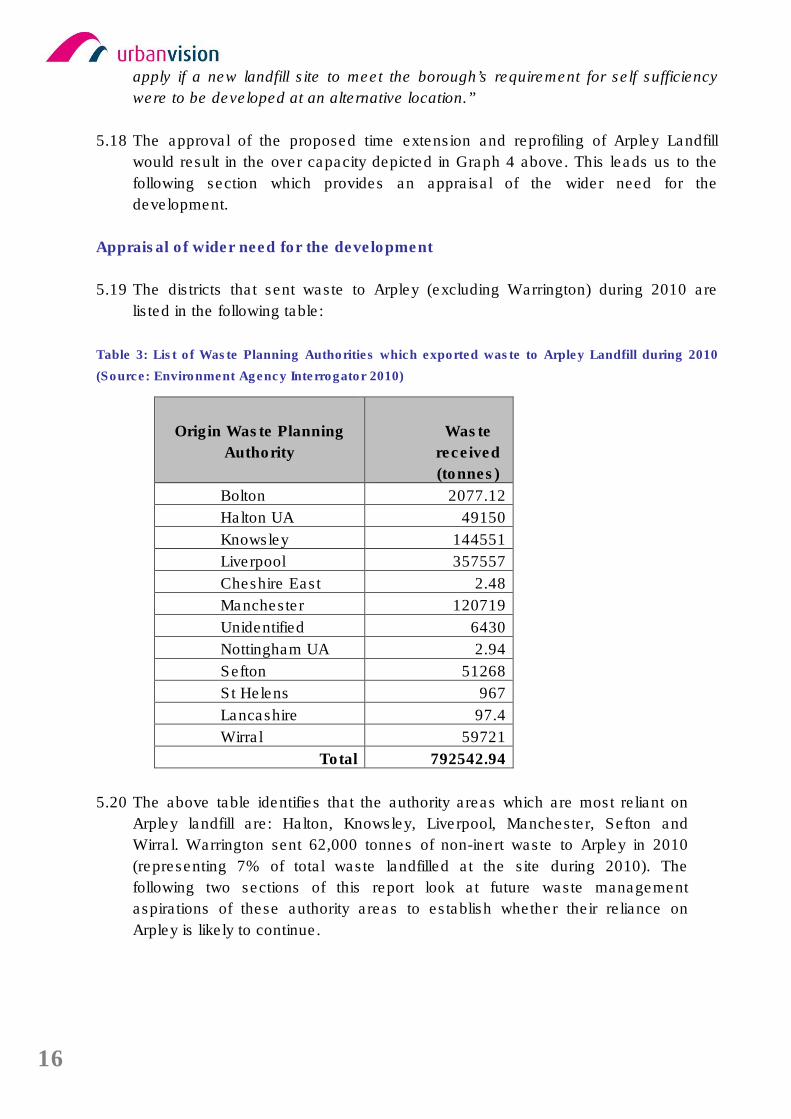
16
apply if a new landfill site to meet the borough’s requirement for self sufficiency
were to be developed at an alternative location.”
5.18 The approval of the proposed time extension and reprofiling of Arpley Landfill
would result in the over capacity depicted in Graph 4 above. This leads us to the
following section which provides an appraisal of the wider need for the
development.
Appraisal of wider need for the development
5.19 The districts that sent waste to Arpley (excluding Warrington) during 2010 are
listed in the following table:
Table 3: List of Waste Planning Authorities which exported waste to Arpley Landfill during 2010
(Source: Environment Agency Interrogator 2010)
Origin Waste Planning
Authority
Waste
received
(tonnes)
Bolton 2077.12
Halton UA 49150
Knowsley 144551
Liverpool 357557
Cheshire East 2.48
Manchester 120719
Unidentified 6430
Nottingham UA 2.94
Sefton 51268
St Helens 967
Lancashire 97.4
Wirral 59721
Total 792542.94
5.20 The above table identifies that the authority areas which are most reliant on
Arpley landfill are: Halton, Knowsley, Liverpool, Manchester, Sefton and
Wirral. Warrington sent 62,000 tonnes of non-inert waste to Arpley in 2010
(representing 7% of total waste landfilled at the site during 2010). The
following two sections of this report look at future waste management
aspirations of these authority areas to establish whether their reliance on
Arpley is likely to continue.
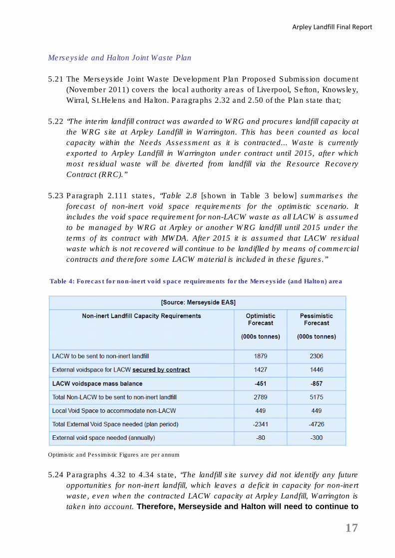
17
Arpley Landfill Final Report
Merseyside and Halton Joint Waste Plan
5.21 The Merseyside Joint Waste Development Plan Proposed Submission document
(November 2011) covers the local authority areas of Liverpool, Sefton, Knowsley,
Wirral, St.Helens and Halton. Paragraphs 2.32 and 2.50 of the Plan state that;
5.22 “The interim landfill contract was awarded to WRG and procures landfill capacity at
the WRG site at Arpley Landfill in Warrington. This has been counted as local
capacity within the Needs Assessment as it is contracted... Waste is currently
exported to Arpley Landfill in Warrington under contract until 2015, after which
most residual waste will be diverted from landfill via the Resource Recovery
Contract (RRC).”
5.23 Paragraph 2.111 states, “Table 2.8 [shown in Table 3 below] summarises the
forecast of non-inert void space requirements for the optimistic scenario. It
includes the void space requirement for non-LACW waste as all LACW is assumed
to be managed by WRG at Arpley or another WRG landfill until 2015 under the
terms of its contract with MWDA. After 2015 it is assumed that LACW residual
waste which is not recovered will continue to be landiflled by means of commercial
contracts and therefore some LACW material is included in these figures.”
Table 4: Forecast for non-inert void space requirements for the Merseyside (and Halton) area
Optimistic and Pessimistic Figures are per annum
5.24 Paragraphs 4.32 to 4.34 state, “The landfill site survey did not identify any future
opportunities for non-inert landfill, which leaves a deficit in capacity for non-inert
waste, even when the contracted LACW capacity at Arpley Landfill, Warrington is
taken into account. Therefore, Merseyside and Halton will need to continue to
18
rely on neighbouring authorities for landfill provision of non-inert waste. [Our
emphasis]. As discussed in the evidence base (Section 2), Merseyside and Halton
has liaised with neighbouring waste planning authorities regarding availability of
non-inert landfill capacity. Unfortunately, each of the neighbouring WPAs have
only accounted for their own needs when determining landfill capacity
requirements, and are not in favour of making provision for Merseyside and
Halton.
However, the waste management industry operates commercial contracts across
local authority boundaries, and discussion with landfill operators across the region
has been more positive with strong indications that the capacity requirements of
Merseyside and Halton can be easily met within the region, although some of
these sites will also be subject to planning applications extending timescales for
landfill operations. The response from industry is backed up by the report,
Nationally, Regionally and Sub-Regionally Significant Waste Management
Facilities (October 2008), produced for the former Regional Assembly to support
RSS, which indicates that landfill sites across the NW region should be considered
as regionally significant facilities.”
5.25 The Merseyside Environmental Advisory Service (MEAS) submitted a consultation
response dated 6th March 2012 to the Arpley planning application on behalf of
Halton, Knowsley, Liverpool City, Sefton, St.Helens and Wirral Councils. The
response acknowledges that authorities in Merseyside and Halton continue to
send Local Authority Collected Waste and some other non-household wastes to
Arpley but also notes that some non-household waste originating in Warrington is
sent to the one operational landfill in Merseyside (Lyme and Wood Pits, Haydock,
St.Helens). This is factual; however, in 2010 approximately 600,000 tonnes was
imported into Arpley from Merseyside and Halton (Table 3), whereas just 30,000
tonnes was sent from Warrington to Lyme and Wood Pits landfill, Haydock,
St.Helens. The MEAS response also quotes the Regional Spatial Strategy in
relation to local authorities being flexible and agreeing to extend operations at
landfill sites in the Region. The response also states “the progressive closure of
other landfills along the Mersey Belt is likely to increase the importance that sites
such as Arpley remain in operation in order to fulfil their strategic role envisaged by
the RSS evidence.”
5.26 Clearly Merseyside and Halton consider Arpley and other North West landfill sites
to be regionally significant facilities and will be hoping they will accommodate
between 80,000 – 300,000 tonnes (bottom row of Table 4 above) of their non-inert
waste per annum.
19
Arpley Landfill Final Report
Greater Manchester Waste Plan
5.27 Since the applicant produced their Supporting Statement the Greater Manchester
Waste Plan (the GM Plan) has been adopted (1st April 2012). The GM Plan
identifies that between 2012 and 2027, a total of 7.8 million tonnes of waste
disposal capacity will be required which will be accommodated at two landfill
facilities. These facilities are Whitehead Landfill in Salford and Pilsworth North in
Bury which are both allocated within the GM Plan for physical extensions.
Paragraphs 2.41 and 2.46 state, “New permissions are required to maintain an
adequate landfill capacity. Adequate means recognising the needs of Greater
Manchester and also the importance of landfill capacity regionally whilst seeking
not to over-provide which may encourage unnecessary landfilling of wastes.”
“The provision of landfill facilities within the Waste Plan is sufficient to deal with the
predicted waste arisings from 2012-2027 and, therefore, the sub region will be self
sufficient in this respect. At a regional level the reduction of suitable landfill
locations means that the sites identified in Greater Manchester must be
recognised as regionally significant especially where, due to new legislation, these
sites fail to fill up at the anticipated rate.”
5.28 The Greater Manchester sub-region is therefore not relying on an extension
of time at Arpley landfill to accommodate its residual waste stream over the Plan
period as it aims to utilise two existing landfill sites allocated for extensions through
allocations within the adopted Plan to meet their needs.
Cheshire East and Cheshire West and Chester
5.29 Cheshire East and Cheshire West and Chester produced a joint Needs
Assessment in May 2011. Section 2.10 identifies that by applying Scenario 1, the
preferred option, and viewing C&I waste arisings against the capacity of facilities
able to treat the waste there would be a shortfall of 50,000 tonnes per annum from
2018. The report states on page 78, “Commercial waste is currently landfilled with
waste at the Gowy Landfill which has a time limited consent until 2017, when a
new landfill will be required unless the consented but not yet operational site at
Kinderton Lodge commences operation which will defer the need for a new landfill
until approx 2025.” [by which time Arpley would be commencing restoration].
5.30 Contact has been made with waste planning officers at both Cheshire authorities
to gain a progress update with regards to their Local Plan preparation. Both
authorities confirmed that the Needs Assessment is the most up-to-date report
available on planning for waste management facilities within their districts.
5.31 Bearing in mind that Kinderton Lodge has an extant planning permission, it would
appear that Cheshire East and Cheshire West and Chester Councils will not
20
be relying on an extension of time at Arpley landfill to accommodate its
residual waste stream.
Assessment of Need Summary
5.32 Warrington is currently largely self sufficient with regards to landfill, however, the
Warrington Needs Assessment identifies that the closure of Arpley after 2013
would result in the need for an alternative site to be opened within Warrington in
order to maintain self sufficiency (see Graphs 1-3 on pages 10 and 11 of this
report for capacity gaps under various waste arising scenarios). If an alternative
site was not identified within Warrington then the waste would have to be exported
thus placing additional pressure upon Gowy landfill (Cheshire West and Chester)
and other landfills further afield to manage the residual element of Warrington’s
waste.
5.33 Warrington is not the only district that relies on Arpley for residual waste disposal
as only 7% of the waste imported to Arpley in 2010 originated from within
Warrington. The Merseyside districts and Halton envisage continued reliance upon
neighbouring authorities to accommodate between 80 and 300,000 tonnes per
annum of their residual LACW and commercial and industrial waste steams up
until 2027 (their Plan period).
5.34 Graph 4 on page 12 of this report shows the demand/capacity relationship should
the extension of time be granted. If permitted there would be a capacity surplus in
excess of 200,000 tonnes per annum for managing Warrington’s waste. This
would result in Warrington remaining as a net importer of waste from across the
region.
5.35 Later sections of this report which focus on the Localism Act, the North West
Regional Spatial Strategy and the Regional Waste Strategy provide evidence that
Arpley should be considered to be a regionally significant site.
6. Assessment of re-profiling proposals, landfill design, phasing and restoration
6.1 The application proposes to extend the working life of the Arpley Landfill by a
further 12 years until 2025 and, relevant to this chapter, includes:-
• re-profiling of some currently landfilled areas
• a revised sequence of landfill phasing;
• restoration scheme for the completed landfill enabling the continued
reclamation of the former dredging deposit ground
• a commitment to continue the provision and management of the Moore Nature
Reserve until 2030
21
Arpley Landfill Final Report
Re-profiling
6.2 Chapter 3 of the Environmental Statement considers three alternative design
scenarios with Option 3 being chosen as the preferred option by the applicant:
• Option 1: Extend the life of the landfill as per the phasing described in the
extant planning permission.
• Option 2: Extend the life of the landfill as per the extant planning permission but
vary the approach to the phasing.
• Option 3: Extend the life of the landfill by re-profiling within the Walton
and Boundary Phases and reducing the plan extent of landfill in the
Arpley phase
6.3 All three options would provide approximately the same capacity of landfill void
and would be operational for the same length of time. Option 3 will raise the
presettlement contours to a maximum height of around 13 metres above current
permitted levels.
6.4 Site cross sections have been provided (figures 5.5a and 5.5b of the ES).
However, although these figures are not to scale they do provide an idea of the
limited impact on the proposed increase in height of the existing landfill from
distant views.
6.5 The applicant has also provided a number of photomontages. Photomontages
8.2b and 8.2d of the ES compares permitted pre settlement views against the
proposed post settlement views. We are unsure as to the value of these
comparisons as there is little, if any, discernible difference in the montages and
any judgement on the visual impact should approach them with caution. There is
a brief mention of photomontages in paragraphs 8.4.22 to 8.4.25, we can find no
justification as to why these comparisons were made and this issue may be raised
with the applicant.
6.6 The ES states at 8.4.26 that “The proposed development would be taller in height
than the consented landfill (and predicted 2013 restored landform) and operations
would be present over a longer duration of time than those currently consented”. It
is clear that there would be an impact on the landscape but that this would be
limited.
6.7 Moving any future landfill operations away from sensitive locations are to be
welcomed and this is enshrined within Option 3. However a 4th option has
not been considered in the ES which would be to develop Option 3. Using
the same footprint but reducing the levels and thereby the quantity of
22
material imported to the site would reduce the visual impact and shorten the
duration of the landfilling operations.
Landfill Design
6.8 The applicant provides details on the landfill design at Section 5.3 of the ES. The
first stages would involve the re-profiling of existing areas of landfill within the
Walton and Boundary Phases of the site. The remaining stages would involve the
creation of new cells within the Boundary and Arpley Phase of the site. In order to
re-profile the site in previously landfill areas the capping would need to be
removed although this will be carried out in a staged manner to avoid large areas
being exposed at any one time. An odour suppression system would be available
as historic wastes are exposed.
6.9 The new cells in the Boundary and Arpley Phases would be excavated to
approximately 8 metres below current ground levels with the excavated material,
most consisting of dredging deposits stockpiled and used for restoration and
engineering of cells.
6.10 The main criteria for the design of a landfill site is to ensure that any wastes or
leachate (liquid that has percolated through the layers of waste material) do not
migrate into adjacent areas.
6.11 The Environment Agency requires that proposals for landfills are designed in such
a way as to protect the environment. The applicant will need to make an
application for an Environmental Permit Application and a Re-profiling
Management Plan would form part of the Environmental Permit for the site. The
Environmental Permit would regulate the permit for the site.
6.12 Landfill Design and construction will be subject to additional regulation
through the Environmental Permitting regime which would control this
aspect of the development
Phasing and Restoration
6.13 The ES states at paragraph 5,3,32 that “The first phase of operations, post 2013,
would involve re-profiling on the existing cells with the Walton and Boundary
Phases of the site. There would be six re-profiling stages resulting in a total of
approximately 2,862,000m3 of void space. Each re-profiling stage is predicted to
last 1 year with the reprofiling waste disposal operations completed by the end of
2019. Waste disposal operations would then commence in the newly constructed
Boundary and Arpley Phase Cells”.
6.14 The phasing and restoration of landfill sites can produce a number of benefits in
that it minimises rainfall soaking into the waste and maximises early completion of

23
Arpley Landfill Final Report
discrete areas or phases to the final pre settlement levels which would allow
maximum landfill gas extraction.
6.15 Furthermore The Environment Agency, as stated earlier, will also regulate the
phasing of the landfill and state that they “expect that operators adopt a principle of
‘Landfill by design’. This means, we expect landfill operators to use sound
scientific techniques and detailed calculations to design a specific solution to
protect the environment from the particular risks at the proposed location”.
(Environment Agency leaflet LFE1- Our approach to landfill engineering issued
10th August 2009)
6.16 Phasing of the landfill will be subject to additional regulation through the
Environmental Permitting regime which would control this aspect of the
development.
6.17 The proposed restoration scheme is indicative only and this is provided in figure
5.10. We would not comment on the broad thrust of the restoration but further
details will need to be provided at some stage and this can be achieved through
the imposition of a planning condition attached to any grant of permission.
6.18 The applicant states in the ES that “the proposed restoration scheme would be
subject to a planning condition that would include the provision of an aftercare
plan. The aftercare plan would address the ongoing management of habitats at the
site to ensure that they provide ongoing ecological benefit to the local area.” No
time scale has been provided for the duration of aftercare. However, due to the
size and complexity of the restored area it is considered that a 10 year
aftercare period or longer would be considered suitable for the Arpley site.
Consideration may also be given to extending the management of the Moore
Nature Reserve to ensure consistency with any extended aftercare scheme.
7. Appraisal of the proposal against national, regional and local waste planning policy
7.1 This section of the report appraises the application in relation to the Development
Plan and relevant additional sources of guidance and policy which should be
considered material considerations in determining the application.
7.2 Within the application documents, Part 2 of the Supporting Statement makes
reference to the range of planning policy and guidance documents which are
considered material considerations by the applicant. The Supporting Statement
focuses on national planning policy in the form of the range of Planning Policy
Statements/Guidance extant at the time of submission. Following the release of
the National Planning Policy Framework, national planning policy for waste
remains within PPS10 but all other planning policy and guidance is now contained
within the Framework.
24
National Planning Policy
National Planning Policy Framework
7.3 The National Planning Policy Framework (NPPF) came into force on 27th March
2012. Whilst the Framework does not contain specific waste policies, as these will
be set out within the National Waste Management Plan (to be published in 2013),
it is clear that local authorities taking decisions on waste applications must have
regard to policies in the Framework so far as relevant. The Government’s policy
on waste management is set out in the National Waste Strategy 2000 (with a
review of the strategy Published in May 2007 “Waste Strategy for England 2007”).
7.4 NPPF reaffirms that the Development Plan is the starting point for decision making
cemented by the “presumption in favour of sustainable development” set out in
paragraph 14. Additionally, when taking decisions, the presumption guides Local
Planning Authorities to grant permission where the development plan is absent,
silent or relevant policies are out of date, unless:
• Adverse impacts of the proposal would ‘significantly and demonstrably
outweigh the benefits when assessed against the policies in the NPPF as
a whole or
• Specific policies in the NPPF indicate the development should be
restricted.
7.5 In the case of Arpley Landfill, the Statutory Development Plan comprises the
‘saved’ policies of the Warrington Borough Council Unitary Development Plan
(UDP) (2006) and the North West of England Regional Spatial Strategy (2008).
7.6 Following the Localism Act attaining Royal Assent (15 November 2011) legislation
is now in place for the future abolition of Regional Spatial Strategies from the
statutory development plan. Their abolition is subject to the appropriate
commencement orders coming into force. There is presently no programme for
these commencement orders. Therefore, policies of the Regional Spatial Strategy
remain extant at this time and are covered in more detail later in this report.
Planning Policy Statement 10: Planning for Sustainable Waste Management
7.7 The NPPF makes clear that, in advance of the publication of the National Waste
Management Plan, the Government’s overall approach to planning and waste
management is set out in Planning Policy Statement 10, “Planning for Sustainable
Waste Management” (PPS10).
7.8 PPS10 sets the overarching objectives for positive planning in the delivery of
sustainable waste management. This includes “providing sufficient opportunities
for new waste management facilities of the right type, in the right place and at the
25
Arpley Landfill Final Report
right time” (Paragraph 2). PPS10 acknowledges that landfill is at the bottom of the
waste hierarchy and that a key objective of national waste policy is to help deliver
sustainable waste management through driving waste up the waste hierarchy by
addressing waste as a resource and looking to disposal as the last option.
Nevertheless PPS10, and the supporting Companion Guide to PPS10, recognises
that disposal by landfill is an option which must be adequately catered for.
7.9 The Arpley proposal is seeking to further contribute towards the
management of residual non-hazardous waste. Whilst landfilling operations
are the least desirable option within the waste hierarchy, PPS10 is clear that
provision for such operations remains necessary. The proposals are
therefore considered compatible with PPS10.
Waste Strategy 2007 and Review of Waste Policy 2011
7.10 Waste Strategy for England (WSE2007), published in May 2007, identifies the
importance of waste management in accordance with the waste hierarchy and
comprises the objectives for waste management and targets for landfill diversion.
Within the application documents, Part 2 Supporting Statement (pg 67) sets out
the range of targets contained within the WSE2007 as relevant to this application.
7.11 A Review of Waste Policy in England was published in 2011 and whilst the
document is not a direct replacement of the Waste Strategy 2007 it aims to update
much of the data and thinking behind the 2007 document. The Review can be
seen as a broad direction of travel, indicating the latest considerations prior to the
production of the National Waste Management Plan in 2013.
7.12 The Review reaffirms England’s commitment to meeting the EU Landfill Directive
Targets (which requires Member States to reduce Biodegradable Municipal Waste
to 50% of 1995 quantities by 2012/13 and 35% of 1995 quantities by 2019/20) and
to sending only residual wastes to landfill. Landfill is confirmed again as a waste
management option for some materials (para 242) for which provision must be
made.
7.13 The proposal includes the development of a landfill gas capture and energy
generation system which will impact positively in relation to the
Government’s energy recovery targets. The proposal will limit the
movement of residual waste arising in Warrington, Merseyside and Cheshire
and therefore contribute to the reduction in greenhouse gas production
associated with road transport of waste. The Arpley proposal is considered
to be in conformity with WSE2007, additionally the Review of Waste Policy
2011 and therefore judged to be in conformity with the emerging national
waste policy direction of travel.
26
Regional Planning Policy
NW Regional Spatial Strategy (2008)
7.14 Whilst it is the Government's intention to revoke existing regional strategies
outside London, this is subject to the outcome of Environmental Assessments and
will not be undertaken until the Secretary of State and Parliament have had the
opportunity to consider the findings of the assessments. As yet there is no
timetable for the revocation of Regional Strategies, therefore the policies within the
North West Regional Spatial Strategy have been set out below and are considered
part of the Development Plan.
7.15 The Regional Spatial Strategy (RSS) for the North West of England was published
on 30 September 2008 and sets the framework for the development of the North
West region over a 15-20 year time period. The North West of England Plan was
drafted and examined in the light of the latest national guidance on sustainable
waste management, including Waste Strategy 2007 and Planning Policy
Statement 10: Sustainable Waste Management. The RSS is therefore compliant
with the most up to date policy framework.
7.16 Policy EM11 ‘Waste Management Principles’ states that “every effort should be
made to minimise waste, maximise re-use, and maximise opportunities for the use
of recycled material. Such residual waste as does arise should be managed at the
highest practicable level in the Government’s waste hierarchy…” The policy goes
on to set out the principles which should be followed (in line with the waste
hierarchy), including waste disposal supported with energy generation from landfill
gas and states that facilities should be provided to allow waste to be managed in
line with these principles.
7.17 The Arpley proposals make provision for waste disposal and also include
landfill gas capture and energy generation. Despite waste disposal being the
final waste management option of the waste hierarchy it is clearly an option
for which provision must be made, therefore the principles of the Arpley
proposals are specifically supported by Regional Spatial Strategy Policy
EM11.
7.18 Policy EM12 ‘Locational Principles’ states that “The final residue, following
treatment, of municipal, commercial and industrial waste should be disposed of in
one of the nearest appropriate installations. Local authorities should ensure that
waste management facilities are sited in such a way as to avoid the unnecessary
carriage of waste over long distances…” EM12 goes on to set out that the location
principles should be balanced against sustainable transport opportunities and the
environmental impact of the proposed development.

27
Arpley Landfill Final Report
7.19 The Arpley Landfill is sited in close proximity to the residual waste arisings
which are currently and proposed to be imported to the site, including waste
arising in Warrington and neighbouring authorities such as Cheshire East,
Merseyside and Halton. Within the application documents (Part 2
Supporting Statement, page 84, Table 4.1) it is confirmed that waste
imported into the site will be moved by road as a result of the anticipated
subregional nature of arisings. Therefore the proposal does not offer any
benefit in terms of sustainable transport of waste. Assessment of the wider
environmental impact(s) of the proposal is not part of this report, but it is
clear that the Council should weigh the environmental impact of the
proposal against the overall need for landfill and general suitability of the
location on relation to waste arisings on a sub regional basis as set out
within Regional Spatial Strategy EM12.
7.20 Policy EM13; ‘Provision of Nationally, Regionally and Sub-Regionally
Significant Waste Management Facilities’ states that “In considering proposals
for waste management facilities (including additional landfill capacity) the ability of
existing established sites to meet the needs of the region / sub-region should be
fully explored. Wherever possible, such sites should be used in preference to other
sites where waste management activities have not previously been located
provided proposals for the development of waste management facilities satisfy
general planning and licensing conditions, including the likely cumulative impact on
the environment, landscape, cultural heritage, groundwater, the amenity and
health of the neighbourhood and residents, the traffic impact; available transport
links; the prevention and control of pollution and any specific technical issues”.
Policy EM13 goes on to state that whilst primary treatment and transfer facilities
should be located close to arisings, secondary treatment and disposal facilities
may be located on a sub regional strategic basis to serve a wider catchment,
specifically acknowledging the needs of the Mersey Belt.
7.21 Policy EM13 supports the continued use of existing landfill facilities in
preference to new sites. This support is caveated to allow Warrington
Council to consider the full range of impacts of a proposal such as the
amenity and health of the neighbourhood and residents, the traffic impact;
available transport links; the prevention and control of pollution. In relation
to the Arpley proposal Warrington Council must balance any possible
impacts set out in Policy EM13 against the impacts which would result from
similar proposals at a site not previously used for waste disposal. Even in
the absence of responses from experts in the field of these impacts it seems
likely that the impacts on a site not previously used for waste disposal would
be greater than at the application site.
7.22 In disposing of waste arising both within Warrington and from neighbouring
authorities, the Arpley proposal is a regionally significant facility. This is
28
supported in Section 5 of this report, where the future landfill requirements
of authorities in the Mersey Belt are set out.
7.23 As highlighted earlier, the policies of the Regional Spatial Strategy remain
extant at this time, but given the Government’s publicised intention to
remove regional tier of planning the material weight attached to the polices
of the North West RSS is diminished. Whilst the figures and capacity
requirements set out within RSS have been superseded with more up to date
information, the principles set out within the Strategy are underpinned with
sound evidence at the regional level, including work carried out by the
Regional Technical Advisory Body. The policies within RSS may soon cease
to be applicable, but as they are based on the waste planning principles
contained within PPS10, it is considered that significant weight be attached
to the RSS policies.
North West Regional Waste Strategy (as updated in 2010)
7.24 The North West Regional Waste Strategy (RWS) was published in September
2004. As set out within the application documents, Part 2 Supporting Statement,
a revised Regional Waste Strategy was published in 2010 which aimed to update
the RWS to reflect legislative, regulatory and policy changes in the form of:
• EU Waste Framework Directive,
• Waste Strategy for England 2007,
• the introduction of the Landfill Allowance Trading Scheme (LATS) and
• RSS for the Northwest (September 2008).
7.25 The application documents assert that significant material planning weight should
be afforded to this updated RWS due to it including current policy and legislation
should be supported.
7.26 The following information sets out the aspects of the updated RWS as relevant to
the Arpley proposals and assesses them in relation to the application.
7.27 A key objective of the updated RWS is to ‘ensure that waste management
infrastructure, facilities and systems are developed in accordance with the
principles of sustainable development, the low carbon agenda and integrated
waste management at the highest practicable level in the Government’s waste
hierarchy, by (amongst other means listed) maintaining sufficient landfill capacity
for the disposal of final residues following treatment and recovery including the
recovery of energy from landfill gas where practicable’.
7.28 The Strategy sets out a series of Policy Statements; section 4.7 contains Policy
Statement 10: Landfill. Of relevance to the Arpley proposals, the Statement
recognises:
29
Arpley Landfill Final Report
• the need for maintaining landfill capacity in the region by restricting the
use of existing landfill capacity to the disposal of final residues and where
the waste has no residual value;
• the provision of any additional landfill capacity should explore the potential
for:
o Extending the timescales where capacity may be used;
o Extending capacity at existing sites; and
o Exploring opportunities for new landfill capacity.
7.29 The Arpley proposal relies on the disposal of residual waste material to be
achieved through an extension of timescale encompassing re-profiling
works at an existing landfill site and is therefore consistent with the
approach set out within the updated Regional Waste Strategy Policy
Statement 10: Landfill.
Local Policies
Warrington Borough Council Unitary Development Plan: Saved Policies
7.30 For the purposes of assessing the Arpley Planning Application the saved policies
of the adopted Warrington Unitary Development Plan (adopted in 2006) constitute
the relevant local policies. Those policies which were saved and, therefore,
continue to constitute part of the Borough's statutory Development Plan which are
relevant to this report are as follows:
7.31 MWA4 ‘Requirements for all Waste Management Applications’ sets out the
range of requirements to support planning applications for waste management
uses such as the Arpley proposals. In summary applicants must include
information relating to the:
• Types/quantities of materials;
• duration of operations and restoration operations;
• hours of operation of the facility, including hours of vehicle movements and
plant or equipment maintenance;
• access arrangements;
• assessment of existing archaeological, ecological, geological,
geomorphological and landscape features and any mitigation measures as
relevant;
• adequate and effective measures to manage the generation of landfill gas
and leachate, both during site operations and after operations have ceased;
• satisfactory and suitable restoration and aftercare measures; and
• information relating to on-site provision for deliveries, collections and
storage of materials, and parking.
30
7.32 The applicant sets out, in paragraph 4.3.5 of the Part 2 Supporting Statement, that
the Environmental Statement addresses the requirements of the policy and is in
compliance with this policy. Urban Vision conclude that the application
documents submitted to Warrington Council includes information relating to
each of the above listed requirements and therefore is judged to be in
compliance with Policy MW4A.
7.33 MWA5 ‘All Minerals and Waste Management Developments’ sets out the range
of considerations which Warrington Council will use to asses planning applications
for waste management uses such as the Arpley proposals. MWA5 requires that
proposals will not have an unacceptable impact upon:
• the green belt;
• urban open space;
• existing or proposed dwellings or other sensitive uses;
• the quality of the water environment,
• the structural integrity and setting of listed buildings;
• sites of archaeological importance;
• the best and most versatile agricultural land;
• public rights of way and the amenity of their users;
• conservation areas;
• Sites of Importance for Nature Conservation;
• features of landscape or geomorphological interest, including the general
setting, protected trees and ancient woodland;
• airport operational safety; and
• highway safety and transport capacity.
7.34 The policy also requires that proposed developments utilise sustainable transport
modes wherever possible, will be sited away from dwellings so as to avoid
unacceptable impacts from site operations or includes sufficient mitigation
measures against such impacts and finally that the proposals include plans for
high quality restoration and aftercare. The Council should ensure they are satisfied
that the proposed development accords with the criteria of Policy MWA5. In order
to assess the proposal against the above criteria the Council will require input from
the relevant expert consultees.
7.35 MWA13 ‘Aftercare’ sets out a requirement for waste management proposals to be
subject to a programme of aftercare management, at a high standard, for a period
of five years following completion of site restoration and applicants are required to
submit an outline scheme as part of the application.
7.36 The Arpley application includes details of the aftercare management of the
landfilling operations within the Environmental Statement (pgs 58-59). In summary,
the applicant sets out, “The aftercare of the site would include maintenance of
grassland, woodland, hedgerows and other habitats in accordance with a long
31
Arpley Landfill Final Report
term management plan to ensure that the ecological and recreational resource is
optimised. It is proposed that the management plan would be secured by a
suitably worded planning condition or obligation. The landscaping at the site has
been designed to integrate with the habitats at Moore Nature Reserve. The
restored site in combination with the nature reserve would provide a significant
area of land dedicated to nature conservation and public recreation. The funding
for the management of Moore Nature Reserve is currently provided for by WRG
under legal agreement with WBC, this funding includes for maintenance works as
well as the provision of one full time and one part time reserve warden. The
funding for the nature reserve would be extended until 2030, providing an
additional 14 years of funding than that currently in place, ensuring that this award
winning nature reserve continues to provide an ecological and educational benefit
to the local area”.
7.37 It is considered that the restoration and post-closure management plans
illustrated within the application conforms to the criteria of Policy MWA13.
However, it is recommended that a longer aftercare period than 5 years is
attached to any grant of planning permission
7.38 Additionally, other UDP policies bear relevance to waste management issues in
relation to the Arpley application, but which are not covered by the scope of this
report, including; GRN1 'The Green Belt', REP1 'The Prudent Use of Resources',
REP2 'Protection of the Best and Most Versatile Agricultural Land', REP9 'Air
Quality', REP10 'Noise', REP11 'Odours', REP13 'Hazardous Uses/Installations'
and REP16 'Renewable Energy'. It is recommended that Warrington assess the
proposals against these policies.
Warrington Borough Council Core Strategy
7.39 On Monday 21st May 2012 Warrington Borough Council published the Proposed
Submission Draft Local Plan Core Strategy. The Core Strategy is emerging policy
and can be seen as an indication of the land use aspirations of Warrington
Council, as such is a material consideration. However the weight attached to the
policies it contains is limited by the fact that it has yet to be subject to Examination
in Public or adopted by the Council and therefore is not part of the current
Development Plan.
7.40 The Proposed Submission Draft Core Strategy includes a specific vision,
objectives and policy (MP8) on waste issues within the Borough. The Core
Strategy supports the production of a separate Joint Minerals and Waste Plan from
2013, and detailed waste policies will be developed within such a document. In
advance of this, the relevant emerging waste policy in relation to the Arpley
proposals is Policy MP8.
32
7.41 Policy MP8 sets out support for sustainable waste management in accordance
with the waste hierarchy. Policy seeks to achieve continual reduction in the
amount of residual waste imported into the borough and encourage waste
minimisation.
7.42 The Arpley proposals involve the disposal of non-hazardous waste arising
from municipal and commercial and industrial (C&I) sources in Warrington,
Merseyside, Halton and Wigan and residual C&I waste from Bolton, Trafford
and Salford. If permitted, the Arpley proposals will result in the continued
importation of residual waste into Warrington. Importantly, the total amount
of waste to be deposited over the length of the new proposal remains the
same as that currently permitted; there is no net increase in waste imported
into Warrington. Policy MP8 seeks a reduction in the amount of waste
imported into the borough and it is clear that the requirement for an
extension of time at Arpley is evidence that waste imports have been lower
than predicted in the current planning permission. This proposal sets out a
12 year extension of operations. Given that the waste planning policy
landscape is changing rapidly, with the release of NPPF and imminent
publication of the national Waste Management Plan and, locally, the
emergence of Warrington’s Local Plan, it seems reasonable to consider
potentially limiting the extension to a shorter time span to allow Warrington
to reconsider the proposals in line with the Core Strategy, containing Policy
MP8, and Joint Minerals and Waste Plan once adopted.
Warrington Municipal Waste Management Strategy
7.43 The draft Municipal Waste Management Strategy (MWMS) for Warrington Borough
Council was published for consultation in June 2008. The final MWMS remains
unpublished and therefore only limited weight can be attributed to the contents of
the draft version. The draft sets out a vision for Warrington “method by which the
authority can deliver sustainable waste management services to the community.
The Council have a vision of sustainable resource use that promotes re-use and
recycling / composting activities and ensures that residual waste can be treated to
maximise recovery and minimise the impacts of final disposal. The Council aims to
improve the quality of services provided to the community and establish best value
waste management practices that encourage reuse, recycling and composting.
The Council also seeks to minimise waste growth and divert significant quantities
of biodegradable waste from landfill”.
7.44 The draft MWMS sets out eight key principles, of which three are particularly
pertinent to the Arpley proposals: ‘Self-sufficiency and the Proximity Principle’,
‘Reduced Reliance on Landfill’ and ‘Less Waste Imported to the Area’
7.45 In respect of the Arpley proposal, it is clear from these draft principles that
Warrington:
33
Arpley Landfill Final Report
• aims to handle its Local Authority Collected Waste (LACW) within the
boundary of the Authority wherever possible;
• recognises that there will always be a need for landfill for residual wastes
and that encourage a reduction in the amount of waste disposed of within
Warrington, the Authority must lead by example; and
• seeks to encourage neighbouring authorities to become self sufficient in the
recycling, recovery and disposal of their own waste with the aim of reducing
waste imported into the Borough.
7.46 The MWMS confirms that the majority of LACW in Warrington is sent to landfill but
outlines the options available to treat and recover value from LACW arising in
Warrington in future including Mechanical Biological Treatment (MBT),
Autoclaving, Advanced Thermal Treatment, Energy from Waste (EfW) and
Combined Heat and Power (CHP).
7.47 The proposals support the achievement of the key principals of the draft
MWMS. Section 5 of this report sets out the current status of neighbouring
Authorities planning strategies as relevant to the Arpley proposals.
Warrington is yet to identify a suitable solution to handle its LACW and
despite neighbouring Authorities striving to achieve self sufficiency this has
yet to be achieved. Therefore it is likely that there will continue to be a need
for residual waste disposal capacity, due to the lack of identified alternative
treatment and disposal sites at present.
Policy Assessment Summary
7.48 In assessing the application against the Development Plan and other material
considerations it is clear that the proposals, in the main fit well with national and
regional policy. However there remain issues, specifically relating to the impacts of
the proposals as set out within local policy, which require further assessment by
Warrington Council.
7.49 This section sets out a summary of the areas of policy which the application has
been assessed against by Urban Vision, as represented in bold text in the section
above.
• PPS10: The Arpley proposal is seeking to further contribute towards the
management of residual non-hazardous waste. Whilst landfilling operations
are the least desirable option within the waste hierarchy, PPS10 is clear
that provision for such operations remains necessary. The proposals are
therefore considered compatible with PPS10.
• Waste Strategy 2007/2011 Review: The proposal includes the
development of a landfill gas capture and energy generation system which
will impact positively in relation to the Government’s energy recovery
34
targets. The proposal will limit the movement of
residual waste arising in Warrington, Merseyside and Cheshire and
therefore contribute to the reduction in greenhouse gas production
associated with road transport of waste. The Arpley proposal is considered
to be in conformity with both WSE2007 and the Review of Waste Policy
2011 and, therefore, judged to be in conformity with the emerging national
waste policy direction of travel.
• NW RSS: The policies of the Regional Spatial Strategy remain extant at this
time, but given the Government’s publicised intention to remove regional
tier of planning the material weight attached to the polices of the North West
RSS is diminished. Whilst the figures and capacity requirements set out
within RSS have been superseded with more up to date information, the
principles set out within the Strategy are underpinned with sound evidence
at the regional level, including work carried out by the Regional Technical
Advisory Body. The policies within RSS may soon cease to be applicable,
but as they are based on the waste planning principles contained within
PPS10, it is considered that significant weight be attached to the RSS
policies.
• RSS Policy EM11: The Arpley proposals make provision for waste disposal
and also include landfill gas capture and energy generation. Despite waste
disposal being the final waste management option of the waste hierarchy it
is clearly an option for which provision must be made, therefore the
principles of the Arpley proposals are specifically supported by Regional
Spatial Strategy Policy EM11.
• RSS Policy EM12: The Arpley Landfill is sited in close proximity to the
residual waste arisings which are currently and proposed to be imported to
the site, including waste arising in Warrington and neighbouring authorities
such as Cheshire East, Merseyside and Halton. Within the application
documents (Part 2 Supporting Statement, page 84, Table 4.1) it is
confirmed that waste imported into the site will be moved by road as a result
of the anticipated subregional nature of arisings. Therefore, the proposal
does not offer any benefit in terms of sustainable transport of waste.
Assessment of the wider environmental impact(s) of the proposal is not part
of this report, but it is clear that the Council should weigh the environmental
impact of the proposal against the overall need for landfill and general
suitability of the location on relation to waste arisings on a sub regional
basis as set out within Regional Spatial Strategy EM12.
• RSS Policy EM13: Policy EM13 supports the continued use of existing
landfill facilities in preference to new sites. This support is caveated to
allow Warrington Council to consider the full range of impacts of a proposal
such as the amenity and health of the neighbourhood and residents, the
traffic impact; available transport links; the prevention and control of
35
Arpley Landfill Final Report
pollution. In relation to the Arpley proposal Warrington Council must balance
any possible impacts set out in Policy EM13 against the impacts which would
result from similar proposals at a site not previously used for waste disposal.
Even in the absence of responses from experts in the field of these impacts it
seems likely that the impacts on a site not previously used for waste disposal
would be greater than at the application site. In disposing of waste arising both
within Warrington and from neighbouring authorities, the Arpley proposal is a
regionally significant facility. This is supported in Section 5 of this report, where
the future landfill requirements of authorities in the Mersey Belt are set out.
• NW Regional Waste Strategy: The Arpley proposal relies on the disposal
of residual waste material to be achieved through an extension of timescale
encompassing re-profiling works at an existing landfill site and is therefore
consistent with the approach set out within the updated Regional Waste
Strategy Policy Statement 10: Landfill.
• Warrington UDP Policy MWA4: Urban Vision conclude that the application
documents submitted to Warrington Council includes information relating to
each of the above listed requirements and therefore is judged to be in
compliance with Policy MWA4.
• Warrington UDP Policy MWA5: The Council should ensure they are
satisfied that the proposed development accords with the criteria of Policy
MWA5. In order to assess the proposal against the above criteria the
Council will require input from the relevant expert consultees.
• Warrington Core Strategy emerging Policy MP8: The Arpley proposals
involve the disposal of non-hazardous waste arising from municipal and
commercial and industrial (C&I) sources in Warrington, Merseyside, Halton
and Wigan and residual C&I waste from Bolton, Trafford and Salford. If
permitted, the Arpley proposals will result in the continued importation of
residual waste into Warrington. Importantly, the total amount of waste to be
deposited over the length of the new proposal remains the same as that
currently permitted; there is no net increase in waste imported into
Warrington. Policy MP8 seeks a reduction in the amount of waste imported
into the borough and it is clear that the requirement for an extension of time
at Arpley is evidence that waste imports have been lower than predicted in
the current planning permission. This proposal sets out a 12 year extension
of operations. Given that the waste planning policy landscape is changing
rapidly, with the release of NPPF and imminent publication of the national
Waste Management Plan and, locally, the emergence of Warrington’s Local
Plan, it seems reasonable to consider potentially limiting the extension to a
shorter time span to allow Warrington to reconsider the proposals in line
36
with the Core Strategy, containing Policy MP8,
and Joint Minerals and Waste Plan once adopted.
• Warrington MWMS: The proposals support the achievement of the key
principals of the draft MWMS. Section 5 of this report sets out the current
status of neighbouring Authorities planning strategies as relevant to the
Arpley proposals. Warrington is yet to identify a suitable solution to handle
its LACW and despite neighbouring Authorities striving to achieve self
sufficiency this has yet to be achieved. Therefore it is likely that there will
continue to be a need for residual waste disposal capacity, due to the lack
of identified alternative treatment and disposal sites at present.
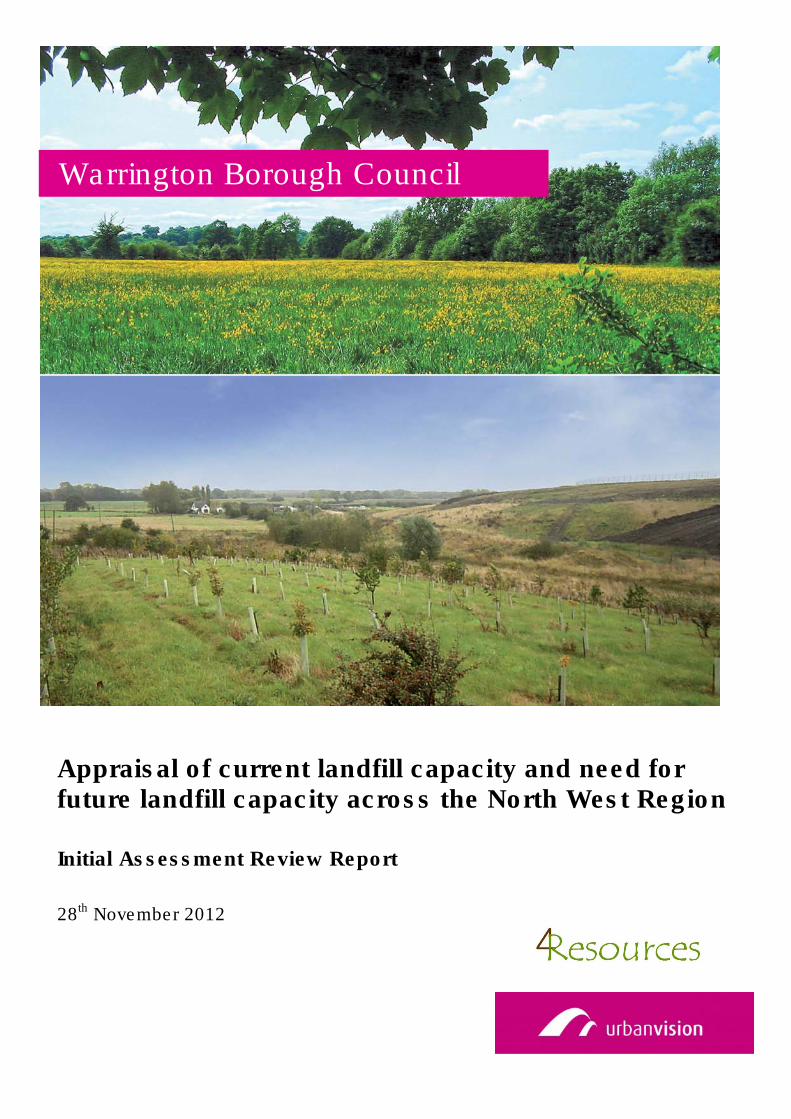
Appraisal of current landfill capacity and need for future landfill capacity across the North West Region
Initial Assessment Review Report
28th November 2012
Warrington Borough Council
CONTENTS
1. INTRODUCTION 1
2. ASSESSMENT OF TOTAL NON HAZARDOUS WASTE DISPOSAL CAPACITY IN
THE NORTH WEST 2
3. MAPPING 6
4. IMPACT OF THE CLOSURE OF ARPLEY ON LANDFILL CAPACITY IN NORTH
WEST 8
5. PLANNING AND POLICY TRENDS IN THE NON HAZARDOUS WASTE STREAM 12
6. FORECAST FROM WASTE DISPOSAL TRENDS IN THE NORTH WEST 14
8. CONCLUSION 21
3
Arpley Landfill - Waste Planning Consultancy Support
Date Details Prepared by Reviewed and approved by
02/11/12 Draft Report Peter Greifenberg/Gill Tatum,
Directors 4Resources Ltd
Philippa Lane, Senior Planner,
Urban Vision
16/11/12 Final Report Peter Greifenberg/Gill Tatum,
Directors 4Resources Ltd
Philippa Lane , Senior Planner,
Urban Vision
28/11/12 Final Report –
reissued
Peter Greifenberg/Gill Tatum,
Directors 4Resources Ltd
Philippa Lane , Senior Planner,
Urban Vision

1
1. INTRODUCTION
Appraisal of wider landfill capacity and direction of demand for landfill in the
North West Region (excluding Cumbria)
1.1 Warrington Borough Council has recently received a planning application that seeks
approval for the extension of operational life of Arpley Landfill facility and ancillary
developments to 2025 including re-profiling, revised sequence of landfill phasing
and restoration.
1.2 The purpose of this report is assist in the determination of the planning application
by providing an appraisal of wider landfill capacity and direction of demand for
landfill in the North West Region. It includes an assessment of what the effect
would be on landfill capacity in the region if the Arpley Landfill site in Warrington
were to close in accordance with its current planning consent, including the impacts
on distances that waste would need to be transported.
2
2. ASSESSMENT OF TOTAL NON-HAZARDOUS WASTE DISPOSAL CAPACITY IN
THE NORTH WEST
2.1 Urban Vision and 4Resources have undertaken research into all existing planning
permissions for non-hazardous landfill in the North West. This excludes capacity in
Cumbria as it is unlikely that waste to be disposed at Arpley Landfill would travel that
distance.
2.2 Therefore, for the purposes of producing this report, the North West is taken to
include Warrington, Lancashire, the five Merseyside Authorities (Liverpool, Sefton,
St Helens, Knowsley and Wirral), Halton, Greater Manchester (including Bolton,
Bury, Manchester, Oldham, Rochdale, Salford, Stockport, Tameside, Trafford and
Wigan), Cheshire West and Chester and Cheshire East.
2.3 Research has been carried out using the following sources; 2011 Environment
Agency Waste Data Interrogator and Reporting tool, Waste Data Flow 2010 and
2011, and direct consultation with the Local Planning officers representing
Merseyside and Halton, Greater Manchester, Lancashire, Cheshire West and
Chester and Cheshire East. The research has identified and collated all existing
planning permissions providing non-hazardous waste landfill capacity in the
northwest (excluding Cumbria).
2.4 An assessment of the available and projected landfill capacity at operational sites
within North West planning authority areas at year end 2009 is shown in Table 1. An
estimate of the remaining capacity at the end of 2013 is also shown. The end of
2013 has been chosen because this is the year that the current Arpley planning
permission finishes. This estimate is based on subtracting the known fill rates for
2010 and 2011 and assuming that years 2012 and 2013 are filled at the same rate
as year 2011. In the light of the recent trend in reducing disposal to landfill it is likely
that this would be an under estimate of remaining available capacity. In making this
estimate a number of sites will have ceased to take waste before the end of 2013.
Waste quantities deposited at these sites have been allocated to alternative sites
(Danes Moss to Maw Green, All Greater Manchester Sites to Pilsworth and Risley to
Pilsworth). No capacity is shown for Arpley as planning permission is presumed to
have ended.
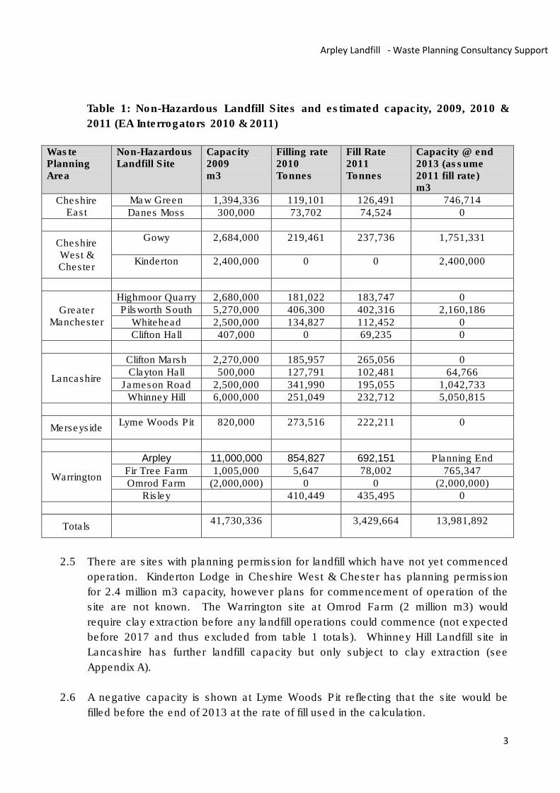
3
Arpley Landfill - Waste Planning Consultancy Support
Table 1: Non-Hazardous Landfill Sites and estimated capacity, 2009, 2010 &
2011 (EA Interrogators 2010 & 2011)
Waste Planning Area
Non-Hazardous Landfill Site
Capacity 2009 m3
Filling rate 2010 Tonnes
Fill Rate 2011 Tonnes
Capacity @ end 2013 (assume 2011 fill rate) m3
Cheshire East
Maw Green 1,394,336 119,101 126,491 746,714 Danes Moss 300,000 73,702 74,524 0
Cheshire West & Chester
Gowy 2,684,000 219,461 237,736 1,751,331
Kinderton 2,400,000 0 0 2,400,000
Greater Manchester
Highmoor Quarry 2,680,000 181,022 183,747 0 Pilsworth South 5,270,000 406,300 402,316 2,160,186
Whitehead 2,500,000 134,827 112,452 0 Clifton Hall 407,000 0 69,235 0
Lancashire
Clifton Marsh 2,270,000 185,957 265,056 0 Clayton Hall 500,000 127,791 102,481 64,766
Jameson Road 2,500,000 341,990 195,055 1,042,733 Whinney Hill 6,000,000 251,049 232,712 5,050,815
Merseyside Lyme Woods Pit 820,000 273,516 222,211 0
Warrington
Arpley 11,000,000 854,827 692,151 Planning End
Fir Tree Farm 1,005,000 5,647 78,002 765,347 Omrod Farm (2,000,000) 0 0 (2,000,000)
Risley 410,449 435,495 0
Totals 41,730,336 3,429,664 13,981,892
2.5 There are sites with planning permission for landfill which have not yet commenced
operation. Kinderton Lodge in Cheshire West & Chester has planning permission
for 2.4 million m3 capacity, however plans for commencement of operation of the
site are not known. The Warrington site at Omrod Farm (2 million m3) would
require clay extraction before any landfill operations could commence (not expected
before 2017 and thus excluded from table 1 totals). Whinney Hill Landfill site in
Lancashire has further landfill capacity but only subject to clay extraction (see
Appendix A).
2.6 A negative capacity is shown at Lyme Woods Pit reflecting that the site would be
filled before the end of 2013 at the rate of fill used in the calculation.
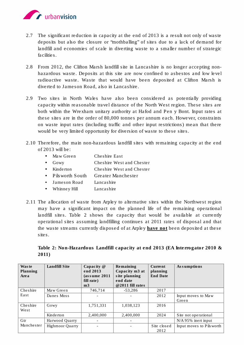
2.7 The significant reduction in capacity at the end of 2013 is a result not only of waste
deposits but also the closure or “mothballing” of sites due to a lack of demand for
landfill and economies of scale in diverting waste to a smaller number of strategic
facilities.
2.8 From 2012, the Clifton Marsh landfill site in Lancashire is no longer accepting non-
hazardous waste. Deposits at this site are now confined to asbestos and low level
radioactive waste. Waste that would have been deposited at Clifton Marsh is
diverted to Jameson Road, also in Lancashire.
2.9 Two sites in North Wales have also been considered as potentially providing
capacity within reasonable travel distance of the North West region. These sites are
both within the Wrexham unitary authority at Hafod and Pen y Bont. Input rates at
these sites are in the order of 80,000 tonnes per annum each. However, constraints
on waste input rates (including traffic and other input restrictions) mean that there
would be very limited opportunity for diversion of waste to these sites.
2.10 Therefore, the main non-hazardous landfill sites with remaining capacity at the end
of 2013 will be:
• Maw Green Cheshire East
• Gowy Cheshire West and Chester
• Kinderton Cheshire West and Chester
• Pilsworth South Greater Manchester
• Jameson Road Lancashire
• Whinney Hill Lancashire
2.11 The allocation of waste from Arpley to alternative sites within the Northwest region
may have a significant impact on the planned life of the remaining operational
landfill sites. Table 2 shows the capacity that would be available at currently
operational sites assuming landfilling continues at 2011 rates of disposal and that
the waste streams currently disposed of at Arpley have not been deposited at these
sites.
Table 2: Non-Hazardous Landfill capacity at end 2013 (EA Interrogator 2010 &
2011)
Waste Planning Area
Landfill Site Capacity @ end 2013 (assume 2011 fill rate) m3
Remaining Capacity m3 at site planning end date @2011 fill rates
Current planning End Date
Assumptions
Cheshire East
Maw Green 746,714 -53,286 2017
Danes Moss - - 2012 Input moves to Maw Green
Cheshire West
Gowy 1,751,331 1,038,123 2016
Kinderton 2,400,000 2,400,000 2024 Site not operational
Gtr Manchester
Harwood Quarry - - N/A 95% inert input
Highmoor Quarry - - Site closed 2012
Input moves to Pilsworth
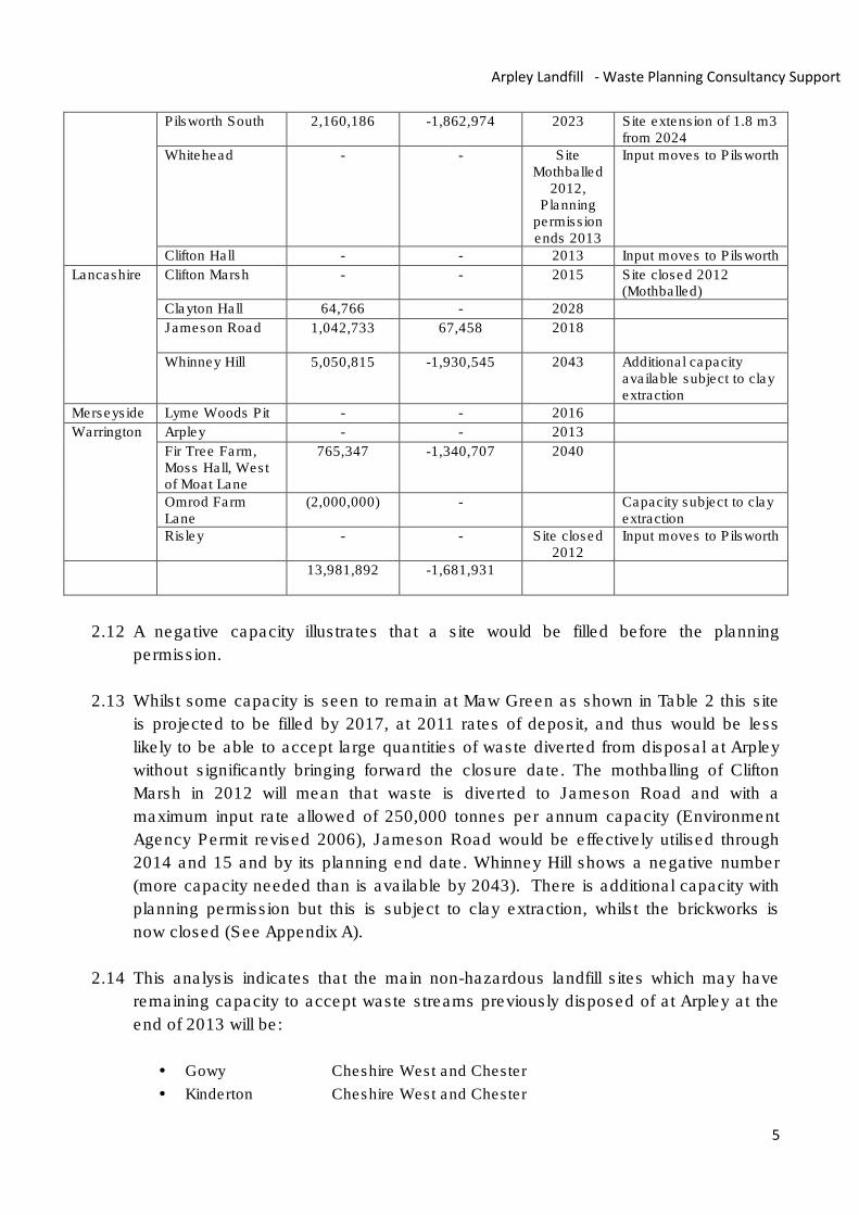
5
Arpley Landfill - Waste Planning Consultancy Support
Pilsworth South 2,160,186 -1,862,974 2023 Site extension of 1.8 m3 from 2024
Whitehead - - Site Mothballed
2012, Planning
permission ends 2013
Input moves to Pilsworth
Clifton Hall - - 2013 Input moves to Pilsworth
Lancashire Clifton Marsh - - 2015 Site closed 2012 (Mothballed)
Clayton Hall 64,766 - 2028
Jameson Road 1,042,733 67,458 2018
Whinney Hill 5,050,815
-1,930,545
2043 Additional capacity available subject to clay extraction
Merseyside Lyme Woods Pit - - 2016
Warrington Arpley - - 2013
Fir Tree Farm, Moss Hall, West of Moat Lane
765,347
-1,340,707
2040
Omrod Farm Lane
(2,000,000) - Capacity subject to clay extraction
Risley - - Site closed 2012
Input moves to Pilsworth
13,981,892 -1,681,931
2.12 A negative capacity illustrates that a site would be filled before the planning
permission.
2.13 Whilst some capacity is seen to remain at Maw Green as shown in Table 2 this site
is projected to be filled by 2017, at 2011 rates of deposit, and thus would be less
likely to be able to accept large quantities of waste diverted from disposal at Arpley
without significantly bringing forward the closure date. The mothballing of Clifton
Marsh in 2012 will mean that waste is diverted to Jameson Road and with a
maximum input rate allowed of 250,000 tonnes per annum capacity (Environment
Agency Permit revised 2006), Jameson Road would be effectively utilised through
2014 and 15 and by its planning end date. Whinney Hill shows a negative number
(more capacity needed than is available by 2043). There is additional capacity with
planning permission but this is subject to clay extraction, whilst the brickworks is
now closed (See Appendix A).
2.14 This analysis indicates that the main non-hazardous landfill sites which may have
remaining capacity to accept waste streams previously disposed of at Arpley at the
end of 2013 will be:
• Gowy Cheshire West and Chester
• Kinderton Cheshire West and Chester
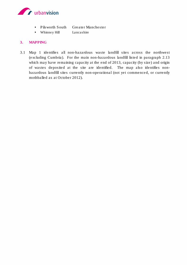
• Pilsworth South Greater Manchester
• Whinney Hill Lancashire
3. MAPPING
3.1 Map 1 identifies all non-hazardous waste landfill sites across the northwest
(excluding Cumbria). For the main non-hazardous landfill listed in paragraph 2.13
which may have remaining capacity at the end of 2013, capacity (by size) and origin
of wastes deposited at the site are identified. The map also identifies non-
hazardous landfill sites currently non-operational (not yet commenced, or currently
mothballed as at October 2012).
7
Arpley Landfill - Waste Planning Consultancy Support
Map 1: Non-hazardous Landfill Sites in Northwest (excluding Cumbria) (waste
flows shown using blue arrows)
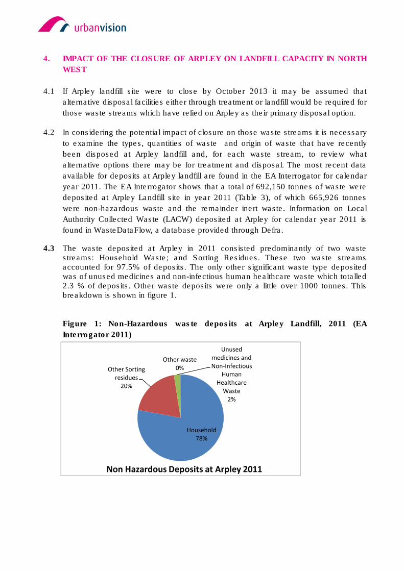
4. IMPACT OF THE CLOSURE OF ARPLEY ON LANDFILL CAPACITY IN NORTH
WEST
4.1 If Arpley landfill site were to close by October 2013 it may be assumed that
alternative disposal facilities either through treatment or landfill would be required for
those waste streams which have relied on Arpley as their primary disposal option.
4.2 In considering the potential impact of closure on those waste streams it is necessary
to examine the types, quantities of waste and origin of waste that have recently
been disposed at Arpley landfill and, for each waste stream, to review what
alternative options there may be for treatment and disposal. The most recent data
available for deposits at Arpley landfill are found in the EA Interrogator for calendar
year 2011. The EA Interrogator shows that a total of 692,150 tonnes of waste were
deposited at Arpley Landfill site in year 2011 (Table 3), of which 665,926 tonnes
were non-hazardous waste and the remainder inert waste. Information on Local
Authority Collected Waste (LACW) deposited at Arpley for calendar year 2011 is
found in WasteDataFlow, a database provided through Defra.
4.3 The waste deposited at Arpley in 2011 consisted predominantly of two waste streams: Household Waste; and Sorting Residues. These two waste streams accounted for 97.5% of deposits. The only other significant waste type deposited was of unused medicines and non-infectious human healthcare waste which totalled 2.3 % of deposits. Other waste deposits were only a little over 1000 tonnes. This breakdown is shown in figure 1.
Figure 1: Non-Hazardous waste deposits at Arpley Landfill, 2011 (EA
Interrogator 2011)
Household
78%
Other Sorting
residues
20%
Unused
medicines and
Non-Infectious
Human
Healthcare
Waste
2%
Other waste
0%
Non Hazardous Deposits at Arpley 2011
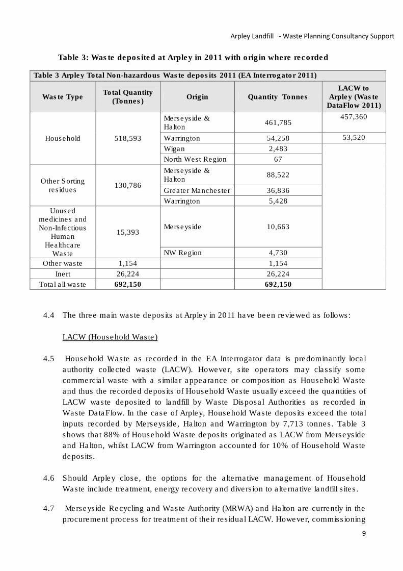
9
Arpley Landfill - Waste Planning Consultancy Support
Table 3: Waste deposited at Arpley in 2011 with origin where recorded
Table 3 Arpley Total Non-hazardous Waste deposits 2011 (EA Interrogator 2011)
Waste Type Total Quantity
(Tonnes) Origin Quantity Tonnes
LACW to Arpley (Waste
DataFlow 2011)
Household 518,593
Merseyside & Halton
461,785 457,360
Warrington 54,258 53,520
Wigan 2,483
North West Region 67
Other Sorting residues
130,786
Merseyside & Halton
88,522
Greater Manchester 36,836
Warrington 5,428
Unused medicines and Non-Infectious
Human Healthcare
Waste
15,393 Merseyside 10,663
NW Region 4,730
Other waste 1,154
1,154
Inert 26,224
26,224
Total all waste 692,150
692,150
4.4 The three main waste deposits at Arpley in 2011 have been reviewed as follows:
LACW (Household Waste)
4.5 Household Waste as recorded in the EA Interrogator data is predominantly local
authority collected waste (LACW). However, site operators may classify some
commercial waste with a similar appearance or composition as Household Waste
and thus the recorded deposits of Household Waste usually exceed the quantities of
LACW waste deposited to landfill by Waste Disposal Authorities as recorded in
Waste DataFlow. In the case of Arpley, Household Waste deposits exceed the total
inputs recorded by Merseyside, Halton and Warrington by 7,713 tonnes. Table 3
shows that 88% of Household Waste deposits originated as LACW from Merseyside
and Halton, whilst LACW from Warrington accounted for 10% of Household Waste
deposits.
4.6 Should Arpley close, the options for the alternative management of Household
Waste include treatment, energy recovery and diversion to alternative landfill sites.
4.7 Merseyside Recycling and Waste Authority (MRWA) and Halton are currently in the
procurement process for treatment of their residual LACW. However, commissioning
of the treatment facilities is not expected until 2015 or 2016. MRWA have a target of
landfilling less than 10% of waste arisings by 2020 and less than 2% by 2030. It is
expected that residual landfill requirements will reduce to low levels soon after
successful commissioning of the new waste treatment facilities. In the interim
period, MWRA anticipate residual household waste landfill requirements in the order
of 350,000 tonnes per annum, which would rise to the order of 380,000 tonnes per
annum including Halton’s landfill requirements. Whilst there are a number of waste
treatment plants within the Merseyside catchment area with planning permissions,
none is adequately progressed to commissioning such that it would become an
alternative interim option from 2013.
4.8 Warrington will not require landfill facilities for its residual LACW from 2013 onwards.
4.9 The closure of Arpley in October 2013 could therefore leave a shortfall in landfill
capacity for LACW in the order of 380,000 tonnes per annum for waste from MRWA
and Halton. It is likely that the total requirement would be around 1 million tonnes in
the period from the closure of Arpley to the commissioning of new treatment
facilities, assuming commissioning does not commence until 2015/16.
Sorting Residues
4.10 Recorded sorting residues deposited at Arpley were 130,786 tonnes for year 2011.
This is a 41% reduction on the 221,876 tonnes recorded as deposited at Arpley in
2010. Sorting residues from Greater Manchester reduced from 147,759 tonnes to
36,836 tonnes whilst sorting residues originating in Merseyside rose from 63,637 to
88,522 tonnes. Sorting residues from these two planning areas accounted for 96%
of sorting residue deposits.
4.11 The overall reduction in sorting residue deposits may reflect the increasing cost of
landfill disposal. The Landfill Tax escalator has increased tax levels from £24.00 per
tonne in 2007 to £64.00 per tonne in 2012, proposed £72 in 2013 and £80.00 in
2014. This increasing cost provides a strong incentive to minimise the quantity of
residual waste and encourages waste producers and management companies to
seek alternative options through waste segregation and additional sorting of waste
for recycling.
4.12 It appears likely that the quantity of sorting residues requiring landfill disposal will
continue to reduce. There is no precise measure of how rapidly this decline will
continue. An ongoing requirement for the landfill disposal in the order of 130,000
tonnes per annum would appear to be a worst case scenario.
4.13 As with LACW, although there are planning permissions for waste treatment plants
in particular within the Merseyside catchment, none is adequately progressed to
commissioning such that it would become an alternative interim option in the short
term (operational at 2013). However in the medium term it remains possible that
treatment options for sorting waste residues will become available.
11
Arpley Landfill - Waste Planning Consultancy Support
Healthcare Waste
4.14 A total of 15,393 tonnes of unused medicines and non-infectious healthcare waste
were deposited at Arpley in 2011. About 70% of this was from Merseyside with the
remainder coming from the North West region. No wastes of these types were
recorded in 2010 and thus alternative options must have been available. Alternative
options would include alternative landfills and also a clinical waste treatment facility.
Other Waste
4.15 Other Waste amounted to 1,154 tonnes in 2011. This quantity may be regarded as
not significant in examining the impact on alternative options and availability.
Summary of Waste Requiring Alternative Disposal from October 2013
4.16 If Arpley were to close by October 2013, waste currently disposed of at the site
which would require alternative disposal options would include:
• LACW Waste - 380,000 tonnes per annum (indicative 1million tonnes in total
to 2015); and
• Sorting Residues - 130,000 tonnes per annum (ongoing or more likely
reducing).
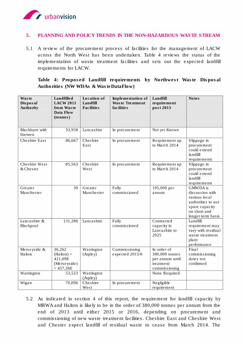
5. PLANNING AND POLICY TRENDS IN THE NON-HAZARDOUS WASTE STREAM
5.1 A review of the procurement process of facilities for the management of LACW
across the North West has been undertaken. Table 4 reviews the status of the
implementation of waste treatment facilities and sets out the expected landfill
requirements for LACW.
Table 4: Proposed Landfill requirements by Northwest Waste Disposal
Authorities (NW WDAs & WasteDataFlow)
Waste Disposal Authority
Landfilled LACW 2011 from Waste Data Flow (tonnes)
Location of Landfill Facilities
Implementation of Waste Treatment facilities
Landfill requirement post 2013
Notes
Blackburn with Darwen
33,958 Lancashire In procurement Not yet Known
Cheshire East 86,667 Cheshire East
In procurement Requirement up to March 2014
Slippage in procurement could extend landfill requirements
Cheshire West & Chester
85,563 Cheshire West
In procurement Requirement up to March 2014
Slippage in procurement could extend landfill requirements
Greater Manchester
39 Greater Manchester
Fully commissioned
105,000 per annum
GMWDA is discussion with various local authorities to use spare capacity on short and longer term basis
Lancashire & Blackpool
131,286 Lancashire Fully commissioned
Contracted capacity in Lancashire to 2025
Landfill requirement may vary with residual waste treatment plant performance
Merseyside & Halton
36,262 (Halton) + 421,098 (Merseyside) = 457,360
Warrington (Arpley)
Commissioning expected 2015/6
In order of 380,000 tonnes per annum until treatment commissioning
Final commissioning dates not confirmed
Warrington 53,523 Warrington (Arpley)
None Required
Wigan 70,096 Cheshire West
In procurement Negligible requirement
5.2 As indicated in section 4 of this report, the requirement for landfill capacity by
MRWA and Halton is likely to be in the order of 380,000 tonnes per annum from the
end of 2013 until either 2015 or 2016, depending on procurement and
commissioning of new waste treatment facilities. Cheshire East and Cheshire West
and Chester expect landfill of residual waste to cease from March 2014. The
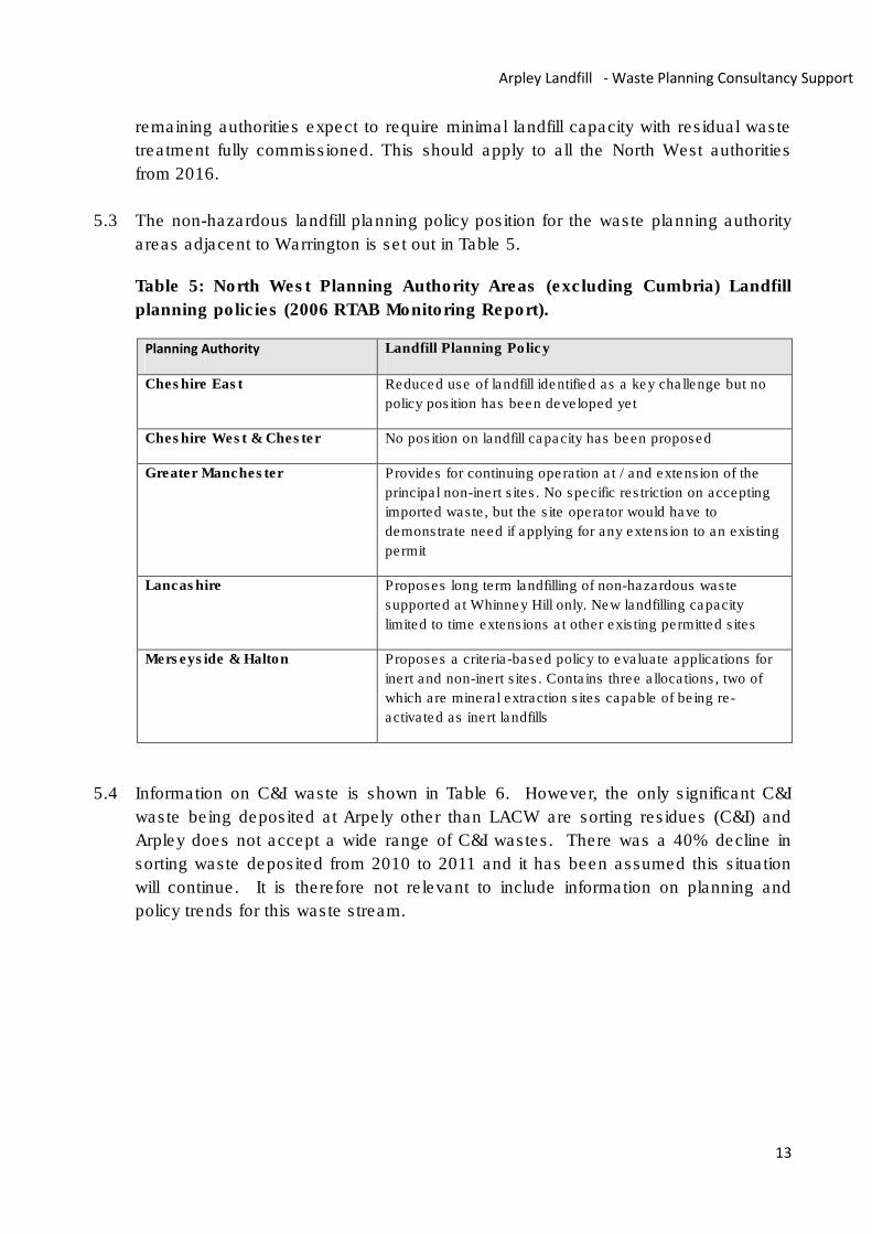
13
Arpley Landfill - Waste Planning Consultancy Support
remaining authorities expect to require minimal landfill capacity with residual waste
treatment fully commissioned. This should apply to all the North West authorities
from 2016.
5.3 The non-hazardous landfill planning policy position for the waste planning authority
areas adjacent to Warrington is set out in Table 5.
Table 5: North West Planning Authority Areas (excluding Cumbria) Landfill
planning policies (2006 RTAB Monitoring Report).
Planning Authority Landfill Planning Policy
Cheshire East Reduced use of landfill identified as a key challenge but no
policy position has been developed yet
Cheshire West & Chester No position on landfill capacity has been proposed
Greater Manchester Provides for continuing operation at / and extension of the
principal non-inert sites. No specific restriction on accepting
imported waste, but the site operator would have to
demonstrate need if applying for any extension to an existing
permit
Lancashire Proposes long term landfilling of non-hazardous waste
supported at Whinney Hill only. New landfilling capacity
limited to time extensions at other existing permitted sites
Merseyside & Halton Proposes a criteria-based policy to evaluate applications for
inert and non-inert sites. Contains three allocations, two of
which are mineral extraction sites capable of being re-
activated as inert landfills
5.4 Information on C&I waste is shown in Table 6. However, the only significant C&I
waste being deposited at Arpely other than LACW are sorting residues (C&I) and
Arpley does not accept a wide range of C&I wastes. There was a 40% decline in
sorting waste deposited from 2010 to 2011 and it has been assumed this situation
will continue. It is therefore not relevant to include information on planning and
policy trends for this waste stream.
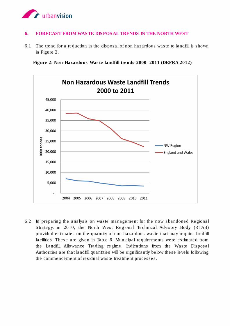
6. FORECAST FROM WASTE DISPOSAL TRENDS IN THE NORTH WEST
6.1 The trend for a reduction in the disposal of non hazardous waste to landfill is shown
in Figure 2.
Figure 2: Non-Hazardous Waste landfill trends 2000- 2011 (DEFRA 2012)
6.2 In preparing the analysis on waste management for the now abandoned Regional
Strategy, in 2010, the North West Regional Technical Advisory Body (RTAB)
provided estimates on the quantity of non-hazardous waste that may require landfill
facilities. These are given in Table 6. Municipal requirements were estimated from
the Landfill Allowance Trading regime. Indications from the Waste Disposal
Authorities are that landfill quantities will be significantly below these levels following
the commencement of residual waste treatment processes.
-
5,000
10,000
15,000
20,000
25,000
30,000
35,000
40,000
45,000
2004 2005 2006 2007 2008 2009 2010 2011
00
0s
ton
ne
s
Non Hazardous Waste Landfill Trends
2000 to 2011
NW Region
England and Wales
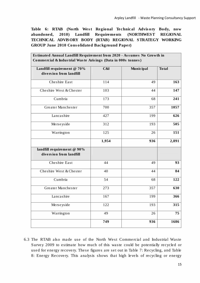
15
Arpley Landfill - Waste Planning Consultancy Support
Table 6: RTAB (North West Regional Technical Advisory Body, now
abandoned, 2010) Landfill Requirements (NORTHWEST REGIONAL
TECHNICAL ADVISORY BODY (RTAB) REGIONAL STRATEGY WORKING
GROUP June 2010 Consolidated Background Paper)
Estimated Annual Landfill Requirement from 2020 - Assumes No Growth in
Commercial & Industrial Waste Arisings (Data in 000s tonnes)
Landfill requirement @ 70%
diversion from landfill
C&I Municipal Total
Cheshire East 114 49 163
Cheshire West & Chester 103 44 147
Cumbria 173 68 241
Greater Manchester 700 357 1057
Lancashire 427 199 626
Merseyside 312 193 505
Warrington 125 26 151
1,954 936 2,891
landfill requirement @ 90%
diversion from landfill
Cheshire East 44 49 93
Cheshire West & Chester 40 44 84
Cumbria 54 68 122
Greater Manchester 273 357 630
Lancashire 167 199 366
Merseyside 122 193 315
Warrington 49 26 75
749 936 1686
6.3 The RTAB also made use of the North West Commercial and Industrial Waste
Survey 2009 to estimate how much of this waste could be potentially recycled or
used for energy recovery. These figures are set out in Table 7: Recycling, and Table
8: Energy Recovery. This analysis shows that high levels of recycling or energy
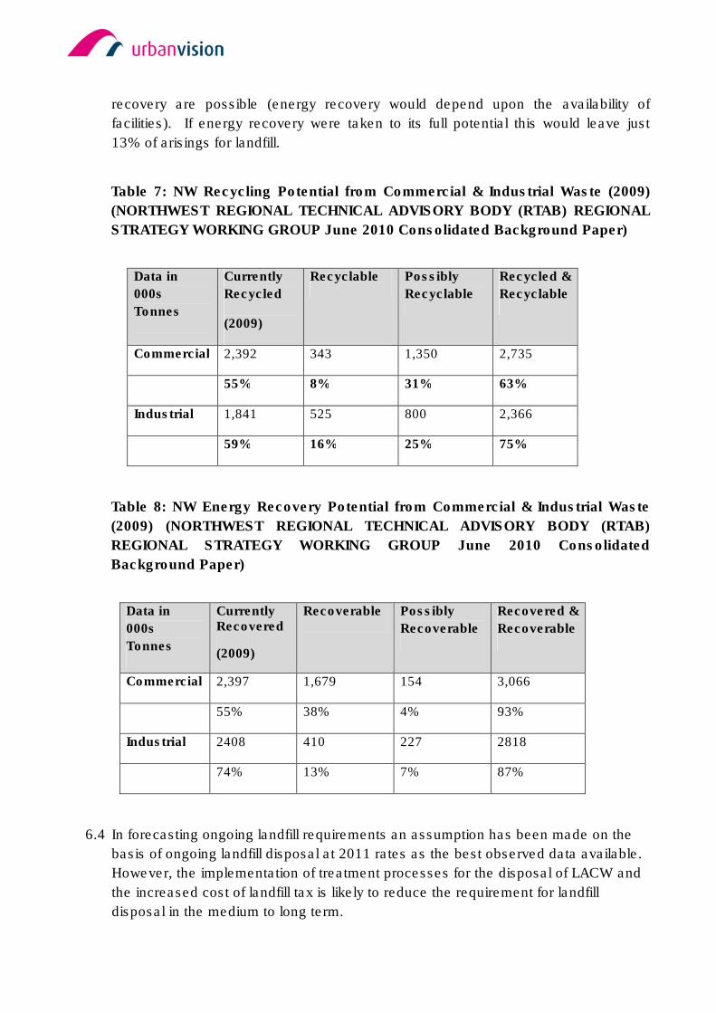
recovery are possible (energy recovery would depend upon the availability of
facilities). If energy recovery were taken to its full potential this would leave just
13% of arisings for landfill.
Table 7: NW Recycling Potential from Commercial & Industrial Waste (2009)
(NORTHWEST REGIONAL TECHNICAL ADVISORY BODY (RTAB) REGIONAL
STRATEGY WORKING GROUP June 2010 Consolidated Background Paper)
Data in
000s
Tonnes
Currently
Recycled
(2009)
Recyclable Possibly
Recyclable
Recycled &
Recyclable
Commercial 2,392 343 1,350 2,735
55% 8% 31% 63%
Industrial 1,841 525 800 2,366
59% 16% 25% 75%
Table 8: NW Energy Recovery Potential from Commercial & Industrial Waste
(2009) (NORTHWEST REGIONAL TECHNICAL ADVISORY BODY (RTAB)
REGIONAL STRATEGY WORKING GROUP June 2010 Consolidated
Background Paper)
Data in
000s
Tonnes
Currently Recovered
(2009)
Recoverable Possibly
Recoverable
Recovered &
Recoverable
Commercial 2,397 1,679 154 3,066
55% 38% 4% 93%
Industrial 2408 410 227 2818
74% 13% 7% 87%
6.4 In forecasting ongoing landfill requirements an assumption has been made on the
basis of ongoing landfill disposal at 2011 rates as the best observed data available.
However, the implementation of treatment processes for the disposal of LACW and
the increased cost of landfill tax is likely to reduce the requirement for landfill
disposal in the medium to long term.

17
Arpley Landfill - Waste Planning Consultancy Support
7. WASTE IN WARRINGTON: WHAT ARE THE ALTERNATIVES TO LAND FILLING
AT ARPLEY?
7.1 The shortfall in capacity resulting from the closure of Arpley in October 2013 is likely
to be in the order of 1 million tonnes (see section 4).
7.2 Although there are planning permissions for new waste treatment plants, in
particular within Merseyside, none are adequately progressed to commissioning
such that they would become an alternative option for the waste streams currently
disposed of at Arpley in the short term. However, in the medium term there are plans
to divert the LACW waste currently disposed of at Arpley to treatment plants, (see
Table 9). It also remains possible that treatment options for Sorting Residues will
become available in the medium to long term. Diversion of significant quantities of
waste to treatment facilities appears impractical in the short term (before the close
of 2013). There is also considerable doubt as to commissioning dates indicated in
Table 9 below and thus additional treatment capacity from 2013 cannot be relied on.
Table 9: Known Planning Position of Waste Treatment Facilities, North West
Region (excluding Cumbria) at October 2012
Planning
Area
Site Total
Annual
Capacity
Start
date
if
post
2012
Actual or
Predicted
throughput
if post
2012
Grid
Reference
Notes
Cheshire
West &
Chester
Ince Marshes
EFW
2015? 600,000 SJ 46700
77000
Under
construction
Ince Marshes
MBT
2015? 100,000 SJ 46700
77000
Under
Construction
Greater
Manchester
Viridor
Reliance Street
MBT 130,000
130,000
Viridor Longley
Lane MBT 125,000
125,000
Viridor Bredbury
Parkway MBT 220,000
220,000
Viridor
Arkwright Street
MBT 120,000
120,000
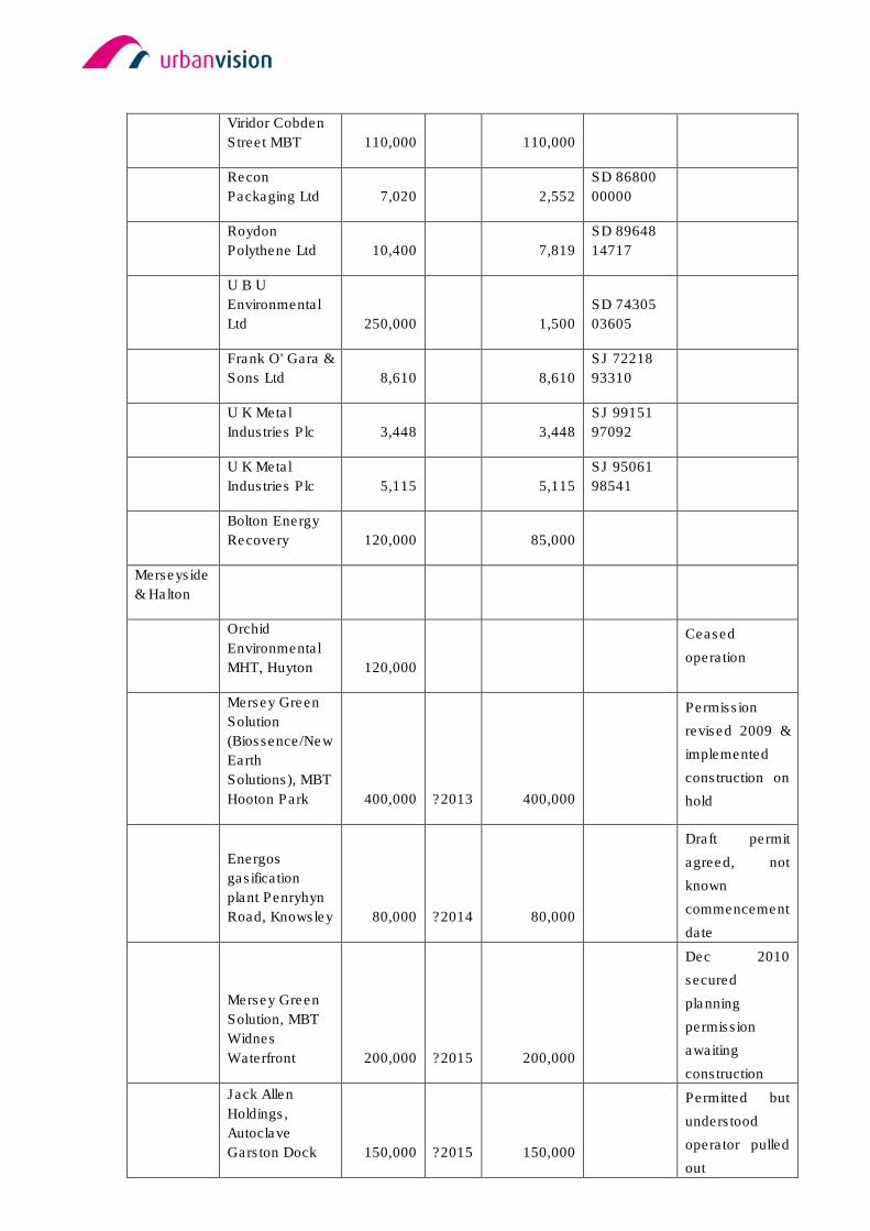
Viridor Cobden
Street MBT 110,000
110,000
Recon
Packaging Ltd 7,020
2,552
SD 86800
00000
Roydon
Polythene Ltd 10,400
7,819
SD 89648
14717
U B U
Environmental
Ltd 250,000
1,500
SD 74305
03605
Frank O' Gara &
Sons Ltd 8,610
8,610
SJ 72218
93310
U K Metal
Industries Plc 3,448
3,448
SJ 99151
97092
U K Metal
Industries Plc 5,115
5,115
SJ 95061
98541
Bolton Energy
Recovery 120,000
85,000
Merseyside
& Halton
Orchid
Environmental
MHT, Huyton 120,000
Ceased
operation
Mersey Green
Solution
(Biossence/New
Earth
Solutions), MBT
Hooton Park 400,000 ?2013 400,000
Permission
revised 2009 &
implemented
construction on
hold
Energos
gasification
plant Penryhyn
Road, Knowsley 80,000 ?2014 80,000
Draft permit
agreed, not
known
commencement
date
Mersey Green
Solution, MBT
Widnes
Waterfront 200,000 ?2015 200,000
Dec 2010
secured
planning
permission
awaiting
construction
Jack Allen
Holdings,
Autoclave
Garston Dock 150,000 ?2015 150,000
Permitted but
understood
operator pulled
out
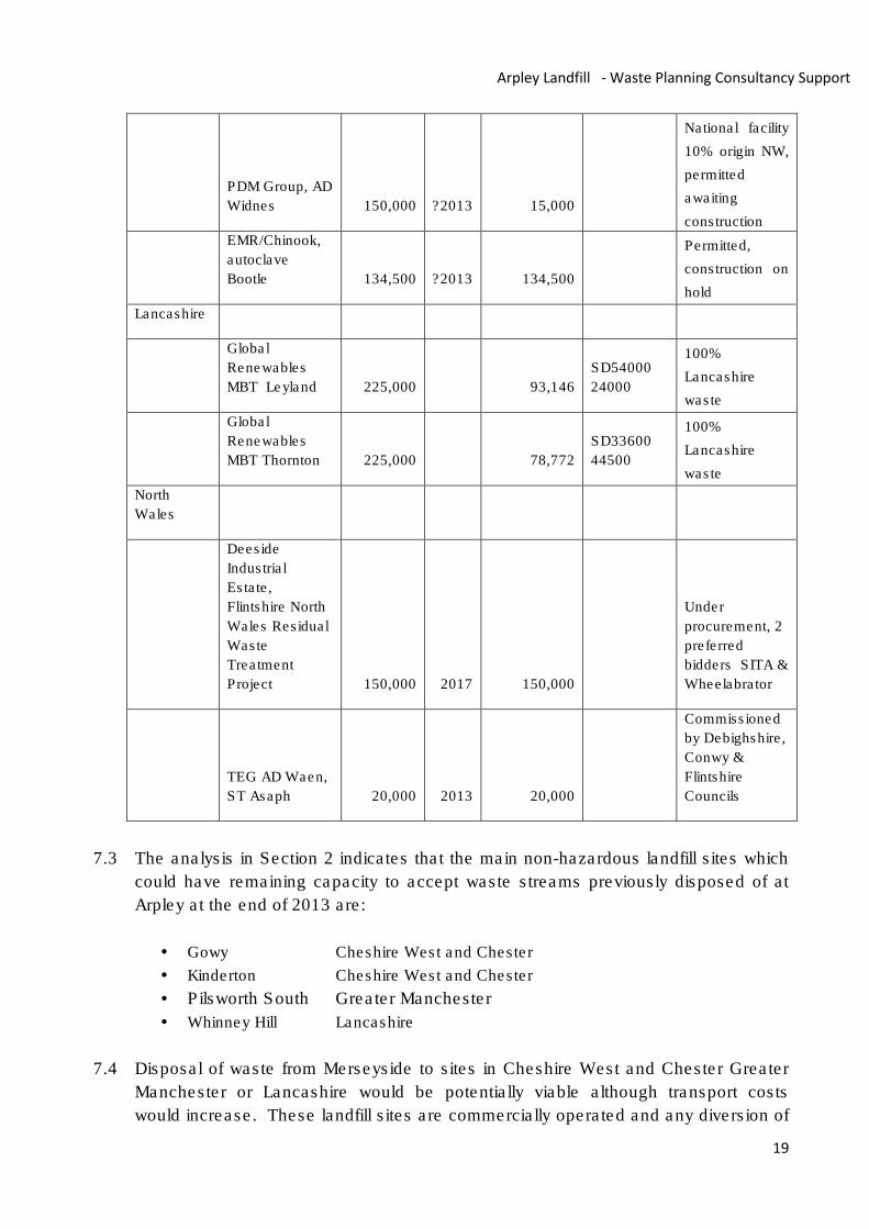
19
Arpley Landfill - Waste Planning Consultancy Support
PDM Group, AD
Widnes 150,000 ?2013 15,000
National facility
10% origin NW,
permitted
awaiting
construction
EMR/Chinook,
autoclave
Bootle 134,500 ?2013 134,500
Permitted,
construction on
hold
Lancashire
Global
Renewables
MBT Leyland 225,000 93,146
SD54000
24000
100%
Lancashire
waste
Global
Renewables
MBT Thornton 225,000 78,772
SD33600
44500
100%
Lancashire
waste
North
Wales
Deeside
Industrial
Estate,
Flintshire North
Wales Residual
Waste
Treatment
Project 150,000 2017 150,000
Under
procurement, 2
preferred
bidders SITA &
Wheelabrator
TEG AD Waen,
ST Asaph 20,000 2013 20,000
Commissioned
by Debighshire,
Conwy &
Flintshire
Councils
7.3 The analysis in Section 2 indicates that the main non-hazardous landfill sites which
could have remaining capacity to accept waste streams previously disposed of at
Arpley at the end of 2013 are:
• Gowy Cheshire West and Chester
• Kinderton Cheshire West and Chester
• Pilsworth South Greater Manchester
• Whinney Hill Lancashire
7.4 Disposal of waste from Merseyside to sites in Cheshire West and Chester Greater
Manchester or Lancashire would be potentially viable although transport costs
would increase. These landfill sites are commercially operated and any diversion of
waste to these sites would only be possible subject to contractual arrangements.
7.5 A controlling factor on the availability of these alternative landfill sites would be the
controls on daily waste or annual waste inputs and vehicle movements.
7.6 Pilsworth South has a planned annual capacity of 600,000 tonnes. In making
projections of available capacity it has been assumed that waste will be diverted
from sites in the Greater Manchester area that are in the process of closing up to
the end of 2013. It would therefore appear possible that capacity at Pilsworth could
be effectively fully utilised. Alternatively however, overall reductions in deposits to
landfill under influences such as the Landfill tax escalator, may result in adequate
additional capacity remaining.
7.7 At the Whinney Hill landfill site, 600,000 tonnes of non hazardous waste per annum
are allowed in the site permit (Deposit data for 2011). However, evidence provided
by SITA, the site operator, raise an issue of availability of void subject to mineral
extraction (see Appendix 1). Detailed negotiation with the landfill operator would be
required to determine the availability of capacity from 2013.
7.8 The Gowy landfill has an indicative remaining capacity in the order of 1.8 million m3
at the end of 2013. There are no planning restrictions on the waste quantity that can
be accepted but there are constraints on the routing of traffic into the landfill site,
with no more than 270 movements in and 270 movements out Monday to Friday
and half the number on Saturdays. The scope for additional waste input would
required detailed analysis of current vehicle movements and the extent to which
large volume bulk loading could utilise remaining vehicle movement numbers
allowed.
7.9 The other site in Cheshire West and Chester is Kinderton Lodge. This site has
permission for 2.4 million m3 capacity and whilst the permission has been activated,
the timescale for commencement of operation is not known. The planning
permission restricts waste receipt through an unilateral undertaking (by the
applicant), which states that no more than 25% of the total tonnage of waste
received per annum or 50,000 tonnes of waste, whichever is the greater, shall be
received on to the land from outside the administrative area of Cheshire County
Council (per annum being each successive 12 month period commencing on landfill
commencement date).
7.10 The mothballed site at Clifton Marsh in Lancashire has a remaining capacity in the
order of 1.8m m3 indicated at the end of 2013 and remains a possible option for
accepting non-hazardous waste for disposal. However, provision of ongoing
capacity cannot be guaranteed as reopening would be subject to negotiations with
the site operator and permitting compliance.

21
Arpley Landfill - Waste Planning Consultancy Support
8. CONCLUSION
8.1 If Arpley were to close by October 2013, non-hazardous waste requiring alternative
disposal options would include;
• LACW Waste - 380,000 tonnes per annum (indicative 1 million tonnes in total
to end 2015)
• Sorting Residues - 130,000 tonnes per annum (ongoing or more likely
reducing year on year)
8.2 The requirement for landfill capacity by MRWA and Halton is likely to be in the order
of 380,000 tonnes per annum from the end of 2013 until either 2015 or 2016
depending on procurement and commissioning of new waste treatment facilities. It
is therefore reasonable to say that this is a short term issue from 2013 – 2015/16
when the commissioning of waste contracts takes effect, assuming there are no
significant delays to the procurement process.
8.3 The Landfill sites with significant remaining capacity at the end of 2013 are:
• Gowy Cheshire West and Chester
• Kinderton Cheshire West and Chester
• Pilsworth South Greater Manchester
• Whinney Hill Lancashire
8.4 There are constraints on the total quantity of waste which each of these sites is able
to accept over and above the remaining sites capacities, either expressed as total
annual quantity through the planning permission or Environment Agency Permit, or
through maximum permitted vehicle movements controls. Revision of these
conditions would require variation to existing planning permissions and permits.
8.5 Whilst the travel distance for disposal from Merseyside to alternative sites in
Cheshire West and Chester, Greater Manchester and Lancashire is practicable, any
use of these sites will require detailed negotiations with the relevant site operators to
determine if these site options are in practice capable of receiving additional waste
deposits.
8.6 Sites currently mothballed and with remaining permitted capacity, for example
Clifton Marsh, could potentially be reopened but this is not a certainty and use of
these sites would be subject to negotiations with the site operator and permitting
compliance.
8.7 It appears unlikely that any single site could provide all of the additional landfill
capacity that has been identified as being required following the closure of Arpley in
October 2013. In theory, dispersal of the identified landfill requirement from 2013 to
2015 or 2016 to more than one, or all of the sites with remaining landfill capacity, is
possible and should be considered as an option, although this would add to the
complexity of contractual arrangements and costs.
8.8 In forecasting ongoing landfill requirements an assumption has been made on the
basis of ongoing landfill disposal at 2011 rates as the best observed data available.
However, implementation of treatment processes for the disposal of LACW and the
increase cost of landfill tax is likely to reduce the requirement for landfill disposal in
the medium to long term and thus estimates made using historic data may
underestimate future remaining capacities.
23
Arpley Landfill - Waste Planning Consultancy Support
Appendix 1
http://lancashire-consult.objective.co.uk/portal/reg27?pointId=1279029012200#section-1279029012200 Lancashire County Council – Waste Planning Consultation 2011
SITA UK have made repeated representations during the Development Framework process warning that Whinney Hill is an active
quarry and availability of landfill void depends on the progress of mineral extraction and weathering. As the quarry has planning
permission to 2042 and the recession has resulted in the associated brickworks being mothballed, it is highly unlikely that all of the
void will be available during the Plan Period to 2021 as the strategy currently assumes. To add to the uncertainties in timing the
eastern half of the site does not yet have an Environmental Permit to operate as a landfill site, yet this void is assumed to be available
during the plan period to 2020. Three fifths of the total landfill void assumed in the DPD to be available over the plan period to 2020
is in Whinney Hill Quarry.


