AP Human Geography: Summer Assignment
Global Geography 1: Africa
Africa is the second largest continent on our planet, and it covers 1/5th of the world’s surface. Your first goal
for the Summer Assignment is to understand the impact of geography on the development of Africa over the
centuries as well as its ability to modernize. You will specifically focus on the following geographical features
of the African continent. This section is worth 1/6 of the Summer Assignment final grade
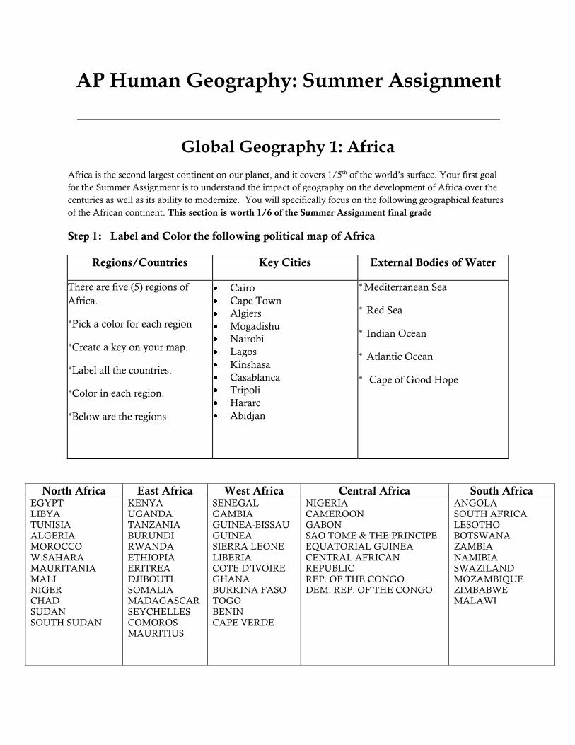
Step 1: Label and Color the following political map of Africa
North Africa East Africa West Africa Central Africa South Africa EGYPT
LIBYA
TUNISIA
ALGERIA
MOROCCO
W.SAHARA
MAURITANIA
MALI
NIGER
CHAD
SUDAN
SOUTH SUDAN
KENYA
UGANDA
TANZANIA
BURUNDI
RWANDA
ETHIOPIA
ERITREA
DJIBOUTI
SOMALIA
MADAGASCAR
SEYCHELLES
COMOROS
MAURITIUS
SENEGAL
GAMBIA
GUINEA-BISSAU
GUINEA
SIERRA LEONE
LIBERIA
COTE D’IVOIRE
GHANA
BURKINA FASO
TOGO
BENIN
CAPE VERDE
NIGERIA
CAMEROON
GABON
SAO TOME & THE PRINCIPE
EQUATORIAL GUINEA
CENTRAL AFRICAN
REPUBLIC
REP. OF THE CONGO
DEM. REP. OF THE CONGO
ANGOLA
SOUTH AFRICA
LESOTHO
BOTSWANA
ZAMBIA
NAMIBIA
SWAZILAND
MOZAMBIQUE
ZIMBABWE
MALAWI
Regions/Countries Key Cities External Bodies of Water
There are five (5) regions of
Africa.
Pick a color for each region
Create a key on your map.
Label all the countries.
Color in each region.
Below are the regions
Cairo Cape Town Algiers Mogadishu Nairobi
Lagos
Kinshasa
Casablanca
Tripoli
Harare
Abidjan
Mediterranean Sea
Red Sea
Indian Ocean
Atlantic Ocean
Cape of Good Hope

Step 2: Label and Color the following on the physical map of Africa:
Step 3: Summation Question:
Please write a 1/2 page written summary to the following question:
What conclusions can you draw from examining in the maps you created for Africa? What
do you think will be some of the advantages and challenges for this continent?
Key Environmental Features Key Features Key Features
There are five (5) key ecological
areas in Africa.
Desert
Semi desert
Steppe
Savanna Grasslands and Woodland Savanna (put together as one on your map) Tropical Rainforest
Directions:
Pick a color for each area.
Create a key on your map.
Color in each area on map.
Internal Bodies of Water:
Lake Victoria
Nile River
Congo River
Niger River
Limpopo River
Zambezi River
Other:
Great Rift Valley
Horn of Africa
Suez Canal
Congo Basin
Tropic of Capricorn
Tropic of Cancer
Mountains:
Atlas Mountains
Drakensberg Mountains
Mt. Kilamanjaro
Ethiopian Highlands
Deserts:
Sahara Desert
Kalahari Desert
Namib Desert

Rubric for Maps:
Points Accuracy Completion Neatness
Exceeds Standard
14-15
All required entries
labeled in correct
place; Summation
question answered
completely.
Not missing any
required entries;
Summation
question is complete
No cross-outs or
erasures noticeable;
use of color; easy to
read; Summation
question answer
typed
Meets Standard
12-14
1-2 entries
incorrect; Question
answered relatively
well.
Missing no more
than 2 entries;
Question answered,
but less than
complete
Use of at least 3
colors; legible;
Question answered
but hand written
Approaches Standard
10-11
3-5 entries
incorrect; Question
not answered well
Missing 3-5 entries;
Limited answer to
question
Little use of color;
somewhat legible;
question hand
written but not
legibly.
Does Not Meet
Standard
9 or
below
More than 5
entries incorrect;
question not
answered
Missing more than
5 entries; question
not answered
Difficult to read;
little effort;
question answer is
completely illegible

PHYSICAL MAP OF AFRICA
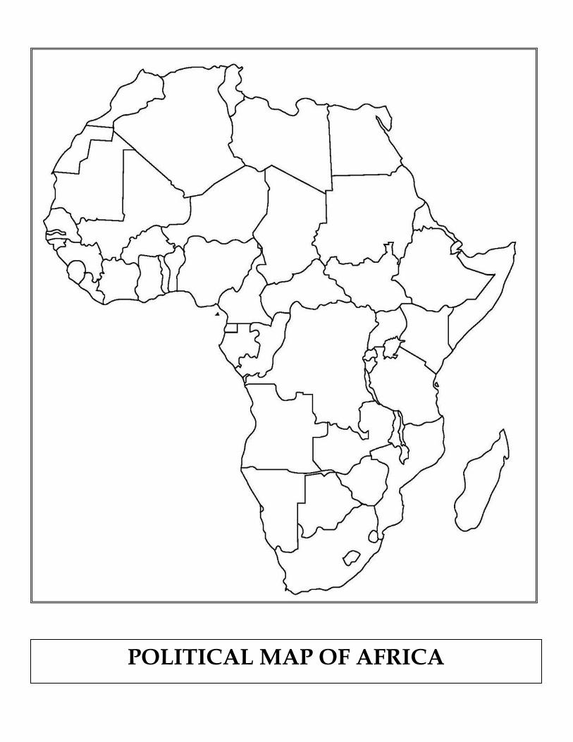
POLITICAL MAP OF AFRICA

AP Human Geography: Summer Assignment
Global Geography 2: South America
You will specifically focus on the following geographical features of the South American continent. This
section is worth 1/6 of the Summer Assignment final grade
Step 1: Label and Color the following political map of South America
Caribbean States Pacific States Atlantic States
Colombia Venezuela
Guyana Suriname
French Guiana*
Ecuador Peru
Bolivia Chile
Brazil Argentina
Uruguay Paraguay
Falkland Islands*
Regions/Countries Key Cities External Bodies of Water
There are five (3) regions of
South America.
Pick a color for each region
Create a key on your map.
Label all the countries.
Color in each region.
Below are the regions
Sao Paulo Buenos Aires Caracas Bogota Lima
Santiago
Rio de Janeiro
La Paz
Montevideo
Asunción
Quito
Caribbean Sea
Pacific Ocean
Atlantic Ocean
Cape Horn

Step 2: Label and Color the following on the physical map of South America:
Step 3: Summation Question:
Please write a 1/2 page written summary to the following question:
What conclusions can you draw from examining in the maps you created for South
America? What do you think will be some of the advantages and challenges for this
continent?
Key Environmental Features Key Features Key Features
There are five (5) key ecological
areas in South America.
Desert
Pampas (grassland)
Tropical Rainforest
Mountain (Alpine)
Temperate forest
Directions:
Pick a color for each area.
Create a key on your map.
Color in each area on map.
Internal Bodies of Water:
Amazon River
Orinoco River
Parana River-
Rio de la Plata
Lake Titicaca
Lake Maracaibo
Other:
Patagonia
Tierra del Fuego
Galapagos Islands
The Llanos
Tropic of Capricorn
Tropic of Cancer
Mountains:
Andes Mountains
Brazilian Highlands
Guiana Highlands
Deserts:
Atacama Desert

POLITICAL MAP OF SOUTH AMERICA

PHYSICAL MAP OF SOUTH AMERICA
AP Human Geography: Summer Assignment
Global Geography 3: Asia
Asia is the largest continent on our planet. This section is worth 1/6 of the Summer Assignment final grade
Step 1: Label and Color the following political map of Asia
Regions/Countries Key Cities External Bodies of Water
There are five (5) regions of Africa.
Pick a color for each region
Create a key on your map.
Label all the countries.
Color in each region.
Below are the regions
Jerusalem Mecca Dubai Baghdad Karachi Tehran Mumbai Shanghai Beijing Hong Kong Seoul Tokyo Manila Bangkok Jakarta Kuala Lampur
Mediterranean Sea Arabian Sea Indian Ocean Pacific Ocean Sea of Japan South China Sea Yellow Sea Bay of Bengal Persian Gulf Red Sea Strait of Hormuz Gulf of Aden Strait of Malacca East China Sea Gulf of Tonkin Philippine Sea
Middle East Central Asia South Asia East Asia Southeast Asia Israel
Jordan
Syria
Lebanon
Saudi Arabia
Yemen
Oman
United Arab Emirates
Qatar
Bahrain
Kuwait
Iraq
Pakistan
Afghanistan
Iran
Tajikistan
Turkmenistan
Kyrgyzstan
Kazakhstan
Uzbekistan
India
Sri Lanka
Maldives
Bangladesh
Nepal
Bhutan
Mongolia
China
Japan
North Korea
South Korea
Taiwan*
Philippines
Myanmar
Thailand
Laos
Cambodia
Vietnam
Indonesia
Brunei
East Timor
Malaysia
Singapore

Step 2: Label and Color the following on the physical map of Asia:
Step 3: Summation Question:
Please write a 1/2 page written summary to the following question:
What conclusions can you draw from examining in the maps you created for Asia? What
do you think will be some of the advantages and challenges for this continent?
Key Environmental Features Key Features Key Features
There are five (6) key ecological
areas in Africa.
Desert
Mountains
Steppe
Grassland
Tropical Rainforest
Coniferous /Temperate forest
Directions: Pick a color for each area.
Create a key on your map.
Color in each area on map.
Internal Bodies of Water:
Caspian Sea Tigris/Euphrates River Yangtze River Yellow River
Mekong River Indus River
Brahmaputra River
Ganges River
Other:
Sundarbans (wetlands) Tropic of Cancer
Mountains:
Himalayas
Hindu Kush
Western and Eastern
Ghats
Zagros
Urals
Kunluns
Mount Fuji
Deserts:
Gobi Desert Arabian Desert Taklamaklan Desert
Thar Desert
Kara Kum Desert
Iranian Desert

PO
LIT
ICA
L M
AP
OF
AS
IA

AP Human Geography: Summer Assignment
PH
YS
ICA
L M
AP
OF
AS
IA

Global Geography 4: Europe
Your fourth goal for the Summer Assignment is to understand the impact of geography on the development of
Europe over the centuries as well as its ability to modernize. You will specifically focus on the following
geographical features of the European continent. This section is worth 1/6 of the Summer Assignment final
grade
Step 1: Label and Color the following political map of Europe
Western Southern Central Eastern Eurasia United Kingdom
Ireland
Norway
Iceland
Sweden
Denmark
Belgium
Luxembourg
Netherlands
France
Spain
Portugal
Andorra
Monaco
Italy
Vatican City
San Marino
Malta
Greece
Cyprus
Bulgaria
Croatia
Bosnia/Herzegovina
Montenegro
Kosovo
Serbia
Macedonia
Albania
Germany
Switzerland
Czech Republic
Liechtenstein
Austria
Slovakia
Hungary
Slovenia
Poland
Finland
Estonia
Latvia
Lithuania
Belarus
Ukraine
Moldova
Romania
Russia
Turkey
Azerbaijan
Georgia
Armenia
Regions/Countries Key Cities External Bodies of Water
There are five (5) regions of
Africa.
Pick a color for each region
Create a key on your map.
Label all the countries.
Color in each region.
Below are the regions
London Paris Berlin Moscow Rome Madrid Budapest Kiev
Bucharest St. Petersburg
Mediterranean Sea
Atlantic Ocean
English Channel
Black Sea
Bay of Biscay Baltic Sea Adriatic Sea Aegean Sea
North Sea Tyrrhenian Sea

Step 2: Label and Color the following on the physical map of Africa:
Step 3: Summation Question:
Please write a 1/2 page written summary to the following question:
What conclusions can you draw from examining in the maps you created for Europe?
What do you think will be some of the advantages and challenges for this continent?
Key Environmental Features Key Features Key Features
There are five (5) key ecological
areas in Africa.
Alpine
Arctic Tundra
Conifer Forest
Mediterranean
Deciduous Forest
Directions:
Pick a color for each area.
Create a key on your map.
Color in each area on map.
Internal Bodies of Water:
Thames River
Danube River
Rhine River
Volga River
Elbe River
Dneiper River
Other:
Massif Central
Meseta
Great Hungarian Plain
Strait of Gibraltar
Central Russian Uplands
Mountains:
Alps
Pyrenees
Carpathians
Caucuses
Urals
Kjolen Mountains
Appenines
Dinarics

PO
LIT
ICA
L M
AP
OF
EU
RO
PE

AP Human Geography: Summer Assignment
PH
YS
ICA
L M
AP
OF
EU
RO
PE
Global Geography 5: North America
North America encompasses Central America and the Caribbean as well. You do not need to know all the
Caribbean islands, just the major ones. This section is worth 1/6 of the Summer Assignment final grade
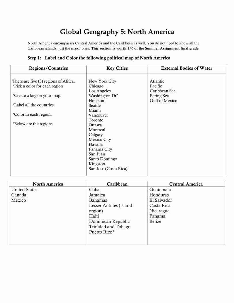
Step 1: Label and Color the following political map of North America
Regions/Countries Key Cities External Bodies of Water
There are five (3) regions of Africa.
Pick a color for each region
Create a key on your map.
Label all the countries.
Color in each region.
Below are the regions
New York City
Chicago Los Angeles Washington DC Houston Seattle Miami Vancouver Toronto Ottawa Montreal Calgary
Mexico City Havana Panama City San Juan Santo Domingo Kingston San Jose (Costa Rica)
Atlantic
Pacific Caribbean Sea Bering Sea Gulf of Mexico
North America Caribbean Central America
United States Canada
Mexico
Cuba Jamaica
Bahamas Lesser Antilles (island
region) Haiti Dominican Republic
Trinidad and Tobago Puerto Rico*
Guatemala Honduras
El Salvador Costa Rica
Nicaragua Panama Belize
Step 2: Label and Color the following on the physical map of North America:
Step 3: Summation Question:
Please write a 1/2 page written summary to the following question:
What conclusions can you draw from examining in the maps you created for North
America? What do you think will be some of the advantages and challenges for this
continent?
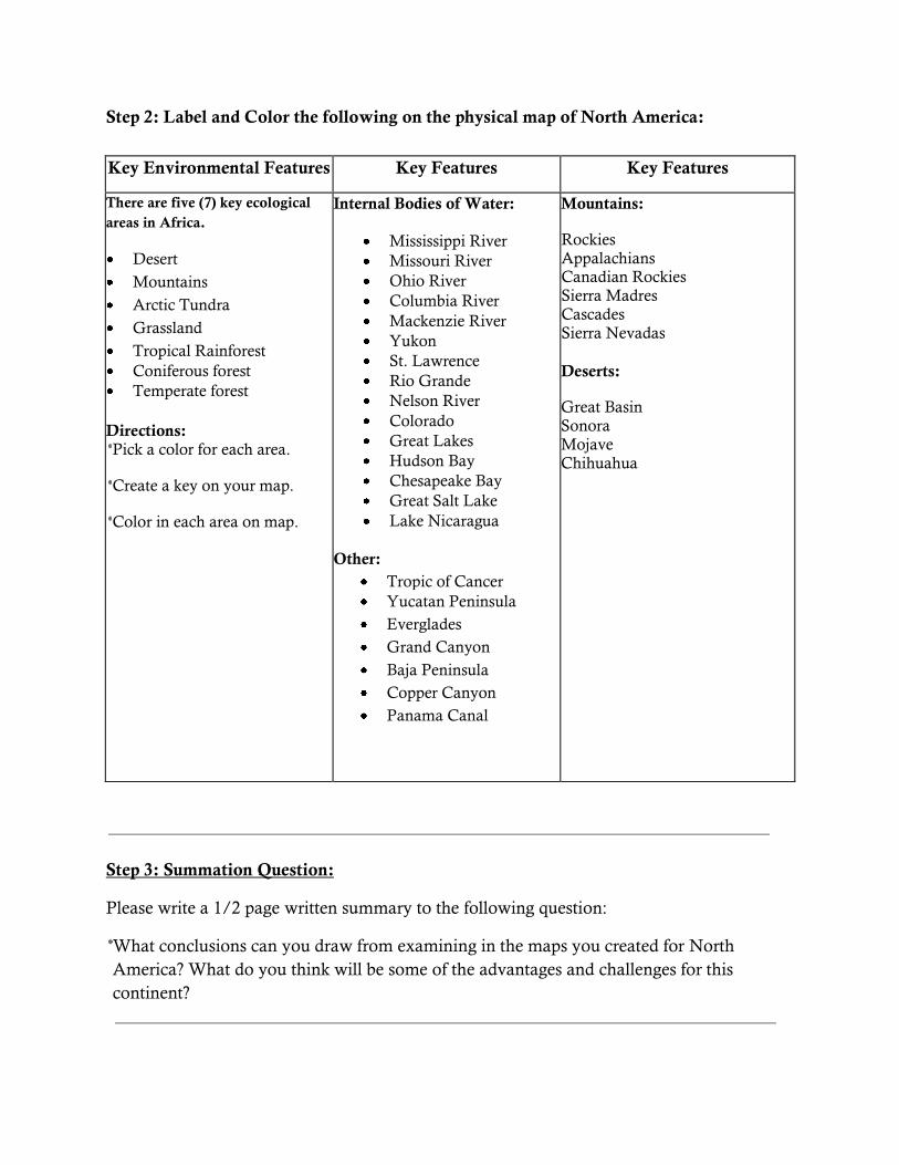
Key Environmental Features Key Features Key Features
There are five (7) key ecological
areas in Africa.
Desert
Mountains
Arctic Tundra
Grassland
Tropical Rainforest
Coniferous forest
Temperate forest
Directions: Pick a color for each area.
Create a key on your map.
Color in each area on map.
Internal Bodies of Water:
Mississippi River Missouri River Ohio River Columbia River
Mackenzie River
Yukon
St. Lawrence
Rio Grande
Nelson River Colorado
Great Lakes
Hudson Bay
Chesapeake Bay
Great Salt Lake
Lake Nicaragua
Other:
Tropic of Cancer Yucatan Peninsula
Everglades
Grand Canyon
Baja Peninsula
Copper Canyon
Panama Canal
Mountains:
Rockies Appalachians Canadian Rockies Sierra Madres Cascades
Sierra Nevadas
Deserts:
Great Basin Sonora Mojave Chihuahua
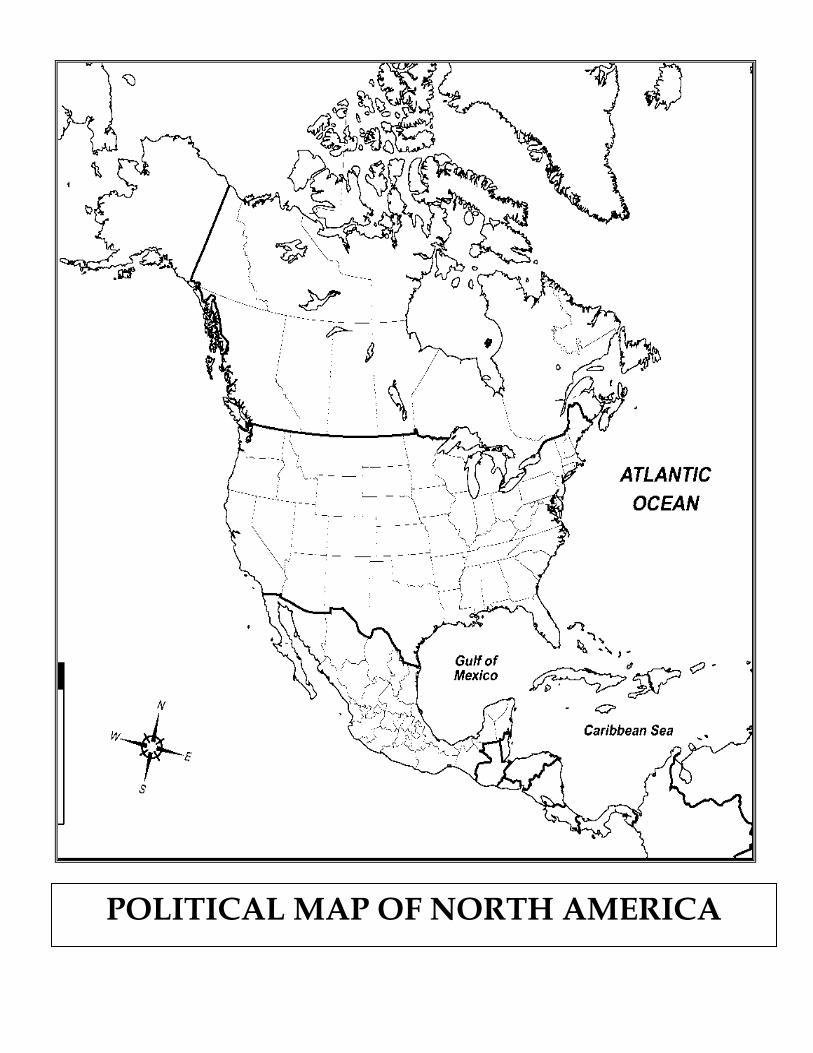
POLITICAL MAP OF NORTH AMERICA

PHYSICAL MAP OF NORTH AMERICA
AP Human Geography: Summer Assignment
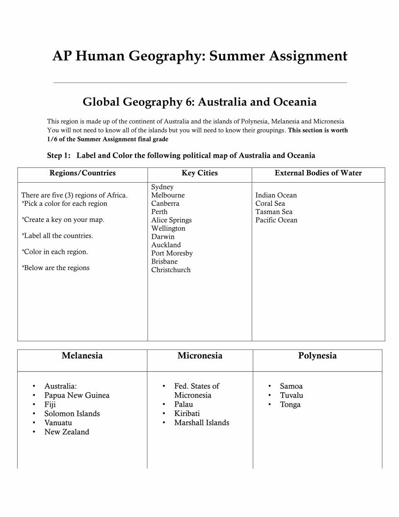
Global Geography 6: Australia and Oceania
This region is made up of the continent of Australia and the islands of Polynesia, Melanesia and Micronesia
You will not need to know all of the islands but you will need to know their groupings. This section is worth
1/6 of the Summer Assignment final grade
Step 1: Label and Color the following political map of Australia and Oceania
Regions/Countries Key Cities External Bodies of Water
There are five (3) regions of Africa.
Pick a color for each region
Create a key on your map.
Label all the countries.
Color in each region.
Below are the regions
Sydney Melbourne Canberra Perth Alice Springs Wellington
Darwin Auckland Port Moresby Brisbane Christchurch
Indian Ocean Coral Sea Tasman Sea Pacific Ocean
Melanesia Micronesia
Polynesia
• AAuussttrraalliiaa:: • PPaappuuaa NNeeww GGuuiinneeaa • FFiijjii • SSoolloommoonn IIssllaannddss • VVaannuuaattuu • NNeeww ZZeeaallaanndd
• FFeedd.. SSttaatteess ooff
MMiiccrroonneessiiaa • PPaallaauu • KKiirriibbaattii • MMaarrsshhaallll IIssllaannddss
• SSaammooaa • TTuuvvaalluu • TToonnggaa

Step 2: Label and Color the following on the physical map of Australia and Oceania:
Step 3: Summation Question:
Please write a 1/2 page written summary to the following question:
What conclusions can you draw from examining in the maps you created for Australia and
Oceania? What do you think will be some of the advantages and challenges for this
continent?
Key Environmental Features Key Features Key Features
There are five (5) key ecological
areas in Africa.
Desert
Mountains
Grassland
Tropical Rainforest
Coniferous /Temperate forest
Directions: Pick a color for each area.
Create a key on your map.
Color in each area on map.
Internal Bodies of Water:
Murray River Murrumbidgee River
Other:
Tasmania
Great Barrier Reef
Mountains:
Carstenz Pyramid
Southern Alps
Puncak Jaya
Australian Alps
Deserts:
Great Victorian Desert Gibson Desert
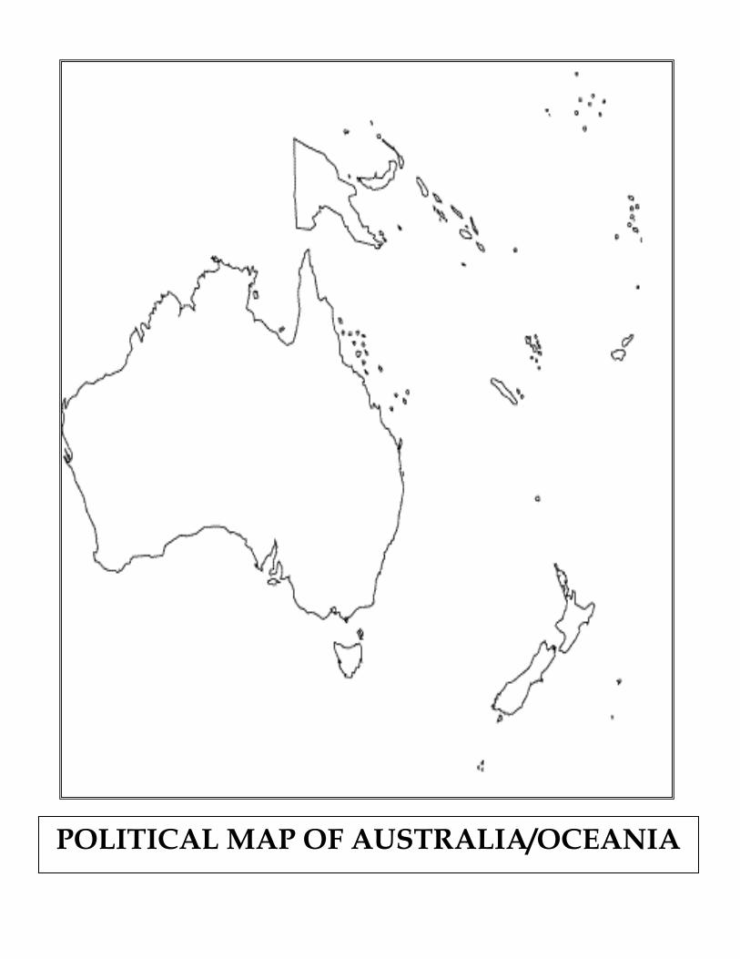
POLITICAL MAP OF AUSTRALIA/OCEANIA
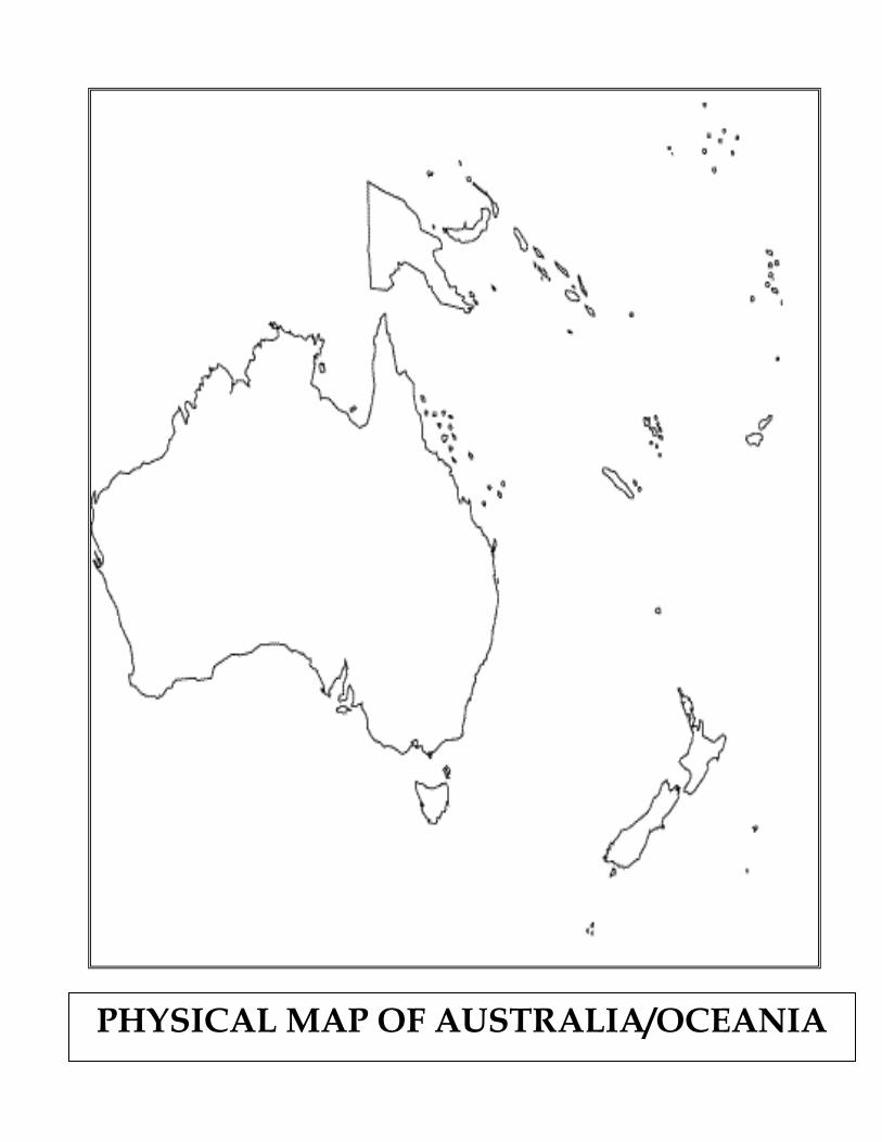
PHYSICAL MAP OF AUSTRALIA/OCEANIA


