
GEOLOGIC JOURNEY
Answer Key
�
The Great LakesChapter 1: Niagara Falls1.1.3 Roughly1.5metres1.1.4 17millionlitresperminute–thelargestintheworld1.1.5 Firstplaceinthe19thcenturywheretherewasafairlyaccurateestimateofpasttime1.1.6 36,000,afewthousandyearsold,4.5billionyears1.1.7 Continentalandoceaniccrust,mantle
Chapter 2: The Legacy of the Grenville Mountains1.2.3 AsaresultofthecollisionofNorthAmerica(knownasRodiniaatthetime)andanother
pieceofoceaniccrust1.2.4 Huge–thesizeoftheHimalayans;10kmshigh,coveredwithsnow,glaciersdraining
awayfromthemountains1.2.5 Thecrustreboundedwhenreleasedfromtheweightoftheicecausingfurthererosion.
Eventually,therootsoftheGrenvilleMountainsroseupandwereexposed.1.2.6 Acombinationofpressureandheat1.2.7 Allcrustalrockscontainradioactiveelements.Whenyouputonelayerontopof
another,theheatistrappedandbeginstobuild.1.2.8 FewplacesintheworldexistwhereyoucanactuallyviewtheEarth’sbuildingblocks;
inthiscase,theverythickmiddleofamountainbelt.1.2.9 Therockscontainnoprimaryfeatures.Allweknowforsureisthattheywereallhot.1.2.10 Uranium-leaddating1.2.11 Theoriginalageoftherockandthetimeofthemelting1.2.12 Onegrainofsedimentaryrock,weighingmuchlessthanonegram1.2.13 TherockshavebeenpaintedbysomeofthegreatestpaintersinCanadianhistory,and
contemporaryartistscontinuetopainttherocks.
Chapter 3: Salt Mines: An Underground Laboratory1.3.3 Newvolcanicmountainsarose,creatinganumberof“sinks”alloverthecontinent.
About400millionyearsago.1.3.4 ItwouldbethesameclimatethatexistsintheCaribbeantoday1.3.5 Createdsaltdepositsthatareminedtoday1.3.6 400millionyearsold1.3.7 Thewhitehorizontallinesindicateyearsofextremeheat.Theblacklinesindicate
cooler,rainierweather.1.3.8 Theydrillcores.

The Great Lakes, continued
GEOLOGIC JOURNEY
Answer Key
�
1.3.9 Itwassovaluedthatwarswerefoughtoverit.Soldiersusedtobepaidinsalt.Itwasanimportantpreservativeformanyyears.
1.3.10 Thattherewasasuddenflood1.3.11 Thisiswherethewavesofthewaterlappedagainsttheshorelinemillionsofyearsago.
Chapter 4: Ice Sheets and Glaciers1.4.7 TheyscouredouttheMichiganbasin(ofsalt)andcreatedtheotherhugecratersthat
becametheGreatLakes.1.4.8 ApinkpebblefromtheCanadianShield,fartothenorthofthebluffs1.4.9 Glacialmeltwater1.4.10 Twelveto15millionyearsago1.4.11 TheeffectofclimatechangeonwaterlevelsbetweenGeorgianBayandLakeHuron1.4.12 Hebelievesitwillcontributeinformationabouttheclimate8500yearsago.1.4.13 LargerthanNiagaraFalls1.4.14 LocatedbetweenGeorgianBayandLakeHuron
The RockiesChapter 1: Plate Tectonics – Formidable Forces2.1.1 Volcanismcouldhaveaddedsomenewrockfromvolcanoes(butnotenoughforall
ofthelandthatdeveloped);areasbelowsealevelcouldhavebeenupliftedformingtheland(wewouldseemostlydeepseasedimentaryrocks,notthecomplexmixtureofrocktypes,overtheCordilleraifthiswerethecase);strikeslipfaultingcouldhavebroughtlandfromelsewhere(somewasaddedthisway).MostofthelandwestoftheoriginalwesternedgeofNorthAmericaisinfact“exotic”materialaddedasaresultofplatesconvergingwiththecontinent.
2.1.2 HowweretheRockiesmade?Whyaretheyfolded?Whatkindofforcewasstrongenoughtobendsolidrock?WhyisthereoilandgoldtrappedintheUSRockiesandnotintheCanadianRockies?Howmuchlongerbeforetheglaciersmeltaway?
2.1.3 Rockatthepeaksofmountainswasonceatthebottomofoceans.ThefoldedandfaultedrocksinthejaggedpeakswereonceasflatasthePrairies.TheRockieswereoncecompletelycoveredinice.
2.1.4 Folding(plasticdeformation)andfaulting(brittledeformation)2.1.5 Exoticrock:rockthatdidnotformwhereitisnow.Exoticrockhasbeenmovedfrom
somewhereelseandthenscrapedoffasubductingplate.Itwillbequitedifferent,overanabruptcontact,totherocksthatitendsupbeingnextto.
2.1.6 Subduction:anoceanicplatethatdescendsbeneathacontinentaloranotheroceanicplate.2.1.7 Basalts

The Rockies, continued
GEOLOGIC JOURNEY
Answer Key
�
2.1.8 Extremelythicksequenceofbasalts(insomeplacesonVancouverIsland.morethan6kmsthick).Therocksaredarkcolouredandheretheyhavebeenerodedtoformtheseacavesandimposingcoastalcliffs.
2.1.9 Formedfrommagmaeruptingrepeatedlyatvolcanicislandsinthemiddleofanocean2.1.10 HawaiioroceanplateaussuchasHessRise.2.1.11 Thebasaltsareathickpileoflavasthatwerepartofanoceanicvolcanicisland.The
volcanicislandwascarriedtowardsNorthAmericaonaplate.TheplatesubductedbeneathNorthAmericaandwhenthevolcanicislandridingalongontheplatecollidedwithNorthAmerica,itwasscrapedoffandaccretedtoNorthAmerica,formingthebasaltsatHesquiat.
2.1.12 • TheoldNorthAmericanmarginwasroughlywheretheAlberta/BCborderistoday.• HesquiatisonthewesternedgeofVancouverIsland,justNorthofthePacificRimNationalPark.
• Wrangellia.• Sixteenaccretedterranes.• Theyaretypicallylongnarrow,squishedlookingbeltsofrock.
2.1.13 • Theoceancrustsubductsbecauseitisthinneranddenserthanthecontinentalcrust.
• Earthquakes(thereisalmostoneperdayrecordedonVancouverIsland),volcanoes(e.g.MtMeager,MtSt.Helens),upliftandcompression-producingmountains(accompaniedbyfoldingandfaulting).
• Whenterranescollidetherearehugeforcesassociatedwiththecollisions.ThesecompressionalforcescausethesedimentsandrocksattheedgeoftheNorthAmericanplatetobuckle(fold)andbreak(fault)astheyarecompressed.
• Everytimeaterraneisadded,anewepisodeoffoldingandfaultingassociatedwiththecollisionoccurs.
2.1.14 • Thedarksoftdrinkbubblesgentlyovertheedgeofthecup,whilethecornsyrupbuildsuppressureandthenexplodesoutmoredramatically.
• The‘magmas’havedifferentviscosities.Thecornsyrupmagmahasahighersilicacontentandisthereforethickerandflowslesseasily–highviscosity.Thesoftdrinkmagmahasalowviscositybecauseofthelowersilicacontent.Theselowviscosity,moremafic(richerinironandmagnesium)magmasalsotendtobehotterandlessgas-richthanthehighersilica(felsic)magmas.Viscousmagmastendtoformhighlyexplosivesteepsidedvolcanos(e.g.Mt.Fuji)andmagmaswithlowviscosities(runny)tendtoformflatsheets(plateausorvolcanoeslikeMaunaLoainHawaii).
• ThelowviscositymaficmagmawouldhaveformedtheHesquiatbasalts.• TheHesquiatbasaltsweren’tsubductedbecausetheyareverythick(andnotquite
asdenseasnormaloceancrust).Theoceancrustisonaveragearound6kmthick.Ifoceancrustwithanadditional5or6kmthickpileofbasalticlavasreachthesubductionzone,thebasaltswillbescrapedoffasterranes.
• TheHawaiianIslands,LineIslandRidge,HessRise,ShatskyRise(theselastthreearealloceanplateaussimilartowhattheHesquiatbasaltswouldhavebeenlikebeforetheycollidedwithNorthAmerica).

The Rockies, continued
GEOLOGIC JOURNEY
Answer Key
�
Chapter 2: From Sea to Sky: Folding and Thrusting2.2.1 Oneexamplewouldbetopushatbothendsofapadofpaper–thepadwillbuckleor
fold.Anotherwaywouldbetotakeasoftgranolabarandsqueezetheendstowardseachother.
2.2.2 Pushingbothendsofastickwithyourhands(thestickwillbreak)ordroppingacuporplateonthegroundisanotherexampleofbrittledeformation.
2.2.3 YouwouldexperiencedifficultieswithreproducingthescaleoftheprocessesandalsowiththeactualconditionsintheEarthsuchasconfiningpressure,duetodepthundertheEarth’ssurfaceaswellastemperatureandtheamountsofforceinvolved.
2.2.4 AllofthemountaintopographyshownintheRockiesisaresultoffoldingandfaulting.Theverticalsedimentarylayersarepartsoffolds,andmanyoftheseeminglyhorizontallayersarepartsofhugefoldsthattoppledoverandarenowlyingflat.Thefaultsthataremostcommon(e.g.inMtYamnuska)arethrustfaults.Theseareverylowangledfaults,alongwhichlargeblocksofrockmovedtowardstheeastastheNorthAmericanplatecollidedwithterranesandcausedvastamountsofhorizontalcompression.
2.2.5 Rocksthatbreakarebrittle.Generallythisiswhathappenstorocksnearthesurfacewhentheyexperiencestresses.Whenrocksareunderalotofconfiningpressure(becausetheyareverydeepinthecrust)andalsoarealothotter,theytendtobehaveinaductileway,likeplastic.
2.2.6 • Image2.1–layersarelyingflat• Image2.2–Layersarelyingflatandyoucanseethecrestornoseofthefold
towardstheleftofthepicture.Axisofthefoldisclosetohorizontal(recumbentfold)• Image2.3–Thelayersagainarefoldedandyoucanseethecrestofthefoldtoward
thetopleftofthephoto.Theaxisofthefoldinalsohorizontal,sothisisarecumbentfoldaswell.
• Image2.4–layersaretiltedsteeply• Image2.5–layersarealmostvertical• Therocklayersinthefirstthreephotosarebentintofoldsthatarenowlyingflator
closetohorizontal,exceptforthenoseofthefold.Thelasttwophotosshowrocklayersthataresteeplytiltedandalmostvertical.
2.2.8

The Rockies, continued
GEOLOGIC JOURNEY
Answer Key
�
2.2.9 ThefirstthreephotoswouldbefromtheMainRangesandthelasttwofromtheFrontRanges.
2.2.10 TheoldestaretheWesternRanges,followedbytheMainRanges,thentheFrontRanges,andtheyoungestaretheFoothillseastoftheFrontRanges.Thecompressionalforcefromtheterranescolliding,bulldozingtheRockies,iscomingfromthewest.Allofthethrustfaults(seecrosssection2.1)showmovementofthethickfoldedsequencesofrockalongthethrustplanesfromthewesttowardstheeast.
2.2.11 • Thelimestonesweredepositedapproximately520millionyearsago.Muchlater(around75millionyearsago)theshaleandsandstoneweredepositedontopofthelimestone.
• Compressionalforcescausedthelimestoneandshale/sandstonepackagetobreak(thrustfault)andaslabofthepackagewaspushedovertopofthesandstonealongthethrustfault.
• Erosionthenworeawaymostofthetopsandstoneandshaleleavingtheolderlimestonelyingontopoftheyoungershaleandsandstone.
2.2.12 Limestoneformedinashallowwarmocean.Sandstoneandshalesformedfromsedimenterodingfromrisingmountainsandterranestothewest.Thelimestoneandoverlyingsandstoneshalepackagesbrokealongalowanglefaultorbreak(higherintheeastandlowerinthewest)sotherockmoveduptheslopeofthefault.Thehugeheightsbuiltupbythisprocesswerethenwornawaybyerosiontoformthemountainsseeninthephotos.
2.2.13 Sketchesoftheabove.2.2.14 Themostimportantwaythatstratigraphersdeterminetheageofspecificrockunitsis
bylookingatthefossilstheycontain.AssemblagesoffossilsfoundatanyageofEarthhistory(e.g.dinosaursintheMesozoic)areuniquetothattimesotheycanbeusedtorelativelydaterockunits.Togetanumericalagerocksmustberadiometricallydated.
2.2.15 Limestoneismostcommonlymadefromtheshellsorhardpartsofmarineorganismssuchascorals,clams,spongesorplankton.Mostlimestonesforminshallow,warmtropicalorsub-tropicaloceanareas.LimestonesareformingtodayinplacesliketheGreatBarrierReef,theCaribbeanandBelize,aswellasinthedeepoceansfromtheaccumulationontheoceanfloorofthecalciteshellsofcertaintypesofplankton.
2.2.16 Forexample,asketchofawarmtropicalreefandadjacentlagoonandbeach.2.2.17 Thesketchoftheoriginalmountainswouldshowsomeveryhigh,jaggedandsteep
mountains,whilethepresent-daysketchwouldshowmuchlower,moreerodedmountains.Thepresent-daysketchshouldincludesomeerosionalfeaturesassociatedwithglacialprocessessinceglacialerosionhasbeenveryimportantfortheRockiesoverthelast2millionyears.
2.2.18 • Itwillvaryeverytimeyoudotheexperiment,butthepossiblestructuresthatyouwouldproduceareallthevarietiesoffoldsincludinganticlines,synclinesandrecumbentfolds.Youmayalsoproducefaults(normaliftheplaneofbreakageisclosetovertical)orthrustfaultsifitisaflattishbreak. TheverticallayersofsandandflouraresimilartothestructuresoftheFrontRanges;otherswithmoreflat-lying

The Rockies, continued
GEOLOGIC JOURNEY
Answer Key
�
layersorfoldsontopofthrustfaultsaresimilartowhatyouwouldseeintheMainRangesoftheRockies.
• Withthisexperimentyouwillbeabletoproducebothplasticdeformation(folding)andbrittledeformation(faulting)bymanipulatingtheoozeindifferentways.
• Gentleprolongedpressurewillcausetheoozetoflow(fold).• Moreforceoverashorttimewillcausetheoozetobreak(fault).• Ithardensandbreaksifforceisappliedquickly.• Compressionalforcesappliedtorocksovermillionsofyearswillcausethefolding
weseeintheRockies.Theaddedforcesassociatedwithcollisionsofterraneswilloftencausemajorepisodesoffaulting,suchasthethrustfaultsweseeintheRockies.
2.2.20 Earthquakes,hotsprings
Chapter 3: Rocky Mountain Resources and Land Use2.3.1 Suggestionsmayincludetheirparks,naturalbeauty,resources,outdooractivity
potential.2.3.2 ProximitytotheRockieswouldmeantheycouldeasilyaccesstheparksandoutdoor
experiencesthattheRockiesoffer.Provincially,theRockiesareimportantforrevenuefromtourismandresourceextraction,andtheyalsopresentsignificantbarrierstotransportationofgoodsfromEasttoWest.Thefurtherawayoneis,thelessdirectimpacttheRockieswouldhave,eitheronanindividual,provincialornationallevel.However,regardlessofproximitytherewillalwaysbetherecognitionthattheRockiesrepresentanimportantreserveofnaturalbeautyandwildernessareassetasideforallCanadians.
2.3.3 • RundleRock–quarriedfromMountRundlenearBanff;nowquarriedjustEastofCanmore/buildingstone,e.g.BanffSpringsHotel
• PaskapooSandstone–quarriedlocally/buildingstoneforschools,banks,churchesandgovernmentbuildingsinWesternCanadaintheearly1900’s.
• PalliserLimestone–minedatExshawandCadomin/cementmaking• WapiabiShale–minedfrombelowMountYamnuska/usedatExshawforthe
productionofcement• Gypsum–minedattheElkhornquarrynearWindermereandtheLussierRiver
quarrynearCanalFlats/usedtomakewallboard(drywall)andcement• Dolomiticshale–BanffFormation/usedtomakemineralwoolnearExshaw.• Ordovicianquartzite–minednearGolden,B.C./usedasasourceofhigh-grade
silica(e.g.Forglass)• Ammolite–outercoatingonsomeJurassicandCretaceousammonites/usedfor
jewellry• Coal–minedatCanmorefromthelate1800’suntil1979/usedbytheCanadianPacificRailwaytofuelcoal-poweredlocomotives,andtodaycoalprovidesmorethan80%ofAlberta’selectricalenergy
• OilandGas–JumpingPoundFoothillsGasField,ElmworthDeepBasinGasFieldintheRockyMountainFoothills(mostofAlberta’soilisfromtheplainstotheeast)/

The Rockies, continued
GEOLOGIC JOURNEY
Answer Key
�
naturalgas,energy,fuel(e.g.JumpingPoundgasfieldsuppliesoverhalfthenaturalgasneedsofCalgary)
2.3.4 Someideasmightbewilderness,nature,tourism,physicalactivitiessuchasskiingandhiking,employment,vacationing,rockclimbing,hotsprings,viewingofwildlife,hunting,etc.
2.3.5 Forexample,downhillskiing.Thecontributingcharacteristicswouldbesteepslopes,accessibility,highmountainsforlongruns.ThepotentialimpactontheRockieswouldbefromdevelopment(roads,hotels),morepeople,lossofpristinenaturalenvironment(skiruns,lodgesetc.).
2.3.6 DesignationofWorldHeritageSiteshttp://whc.unesco.org/en/list/304andcreationofparkswhichlimitdevelopment
2.3.7 Buildingofroads,houses,facilities,wastedisposal,pollution,barrierstowildlifemigrationbecauseofsettlements,roads,railways,slopeinstabilitiesassociatedwithrailwaycuts,logging,resourceextraction
2.3.8 Pristinewildernesswithnodevelopmentwillallowthenaturalenvironment,includingthewildlife,tobepreservedforfuturegenerations.Allowingdevelopmentwillaltertheenvironmentthatdrewpeoplethereinthefirstplace,butwillalsoprovidejobsandallowpeopletoenjoyandbenefitfromtheirexperienceofthewildernessdirectly.
2.3.9 Mines:• NorthwestB.C. EskayCreek–gold,silver Endako–molybdenum Huckleberry–copper,molybdenum TableMountain–gold• CentralB.C. KemessSouth–copper Gibraltar–copper,molybdenum MountPolley–copper,gold,silver• SouthCentralB.C. HighlandValley–copper,molybdenum,gold,silver• SouthwestB.C. MyraFalls–copper,zinc,silver,gold
Chapter 4: Erosion on a Grand Scale2.4.1 TheHimilayasarehighest,steepestandmostrugged.TheAppalachiansarelowest,
mostroundedandleastrugged.2.4.2 Mountainsthatareintheprocessofbeingformed,e.g.theHimalayas,willbesteeper
andhigherbecausethetectonicforcesthatarepushingthemuparestillactive.Thelongeragoamountainrangeformed,themoretimetherehasbeenforerosiontowearawaythepeaksbyremovingrock,grainbygrainorpebblebypebble.BoththeAppalachiansandtheRockieswhentheyfirstformed(~340myago,and~60myagorespectively)wouldhavelookedverymuchliketheHimalayastoday.
2.4.3 Criteriamightbeageofthemountainsi.e.whentheyformed(AppalachiansinthePaleozoic,theRockiesintheMesozoic,andtheWesternGhatsintheHimalayasarestillforming).Othercriteriacouldbebythehighestpeakineachrangeorhowroundedorruggedthemountainsare,bothofwhicharerelatedtotheageandthe

The Rockies, continued
GEOLOGIC JOURNEY
Answer Key
�
amountoftimethaterosionhasbeenwearingtherocksaway.Othercriteriamightbewhetherthemountainshaveglaciersornot(dependssomewhatonheight,rainfallaswellaslatitude),orthetypesofrocksthemountainsaremadeof.
2.4.4 • GlaciationhasshapedtheRockiesthrougherosionaswellasdeposition.• Erosionalfeaturesinclude:Ushapedvalleys,hangingvalleys,cirques,arêtes,
horns,glaciallakes,polishedrock,grooves,rochemoutonee.Glacialdepositionalfeaturesincludemoraines(terminal,recessional,lateral,medial),otherdepositsoftill,drumlins,eskers,outwashplains,erratics.
2.4.5 Sketchesofthedepositionalfeaturesnotedabove2.4.7 Themudstonewouldlikelybetheleastresistant,withthesandstonenextandfinally
thelimestonewhichisthemostresistant.Theseresultsmatchupwellwithwhatyouseeinthevideo,sincemanyofthehighestpeaksaremadeoflimestone.Theexposuresofshaleormudstoneareoftencoveredwithvegetationandappearmoreerodedandrecessive.Sandstoneisinbetween–harderthanshalebutsoftergenerallythanlimestone.
2.4.8 Theyaremeasuringthethicknessoftheice.Thiswillenablethemtoestimatethetotalmassoftheiceandovertimeseeifthetotalmassisincreasingordecreasing,andfromthiswhethertheicesheetismeltingawayorgrowing.Theyarealsomeasuringthethicknessofthelastwinterlayerofsnowwhich,whencomparedovertheentireicesheetwiththeamountofmeltwaterlost,willtellthemiftheicesheetisgettingsmaller.
2.4.9 Vastamountsofmeltwaterflowingawayfromtheiceinriversandwaterfalls,andthehugecrevassesintheglaciers,andthemoulins.ThemorainesatthefrontedgeoftheAthabascaglacierarebeingdepositedfurtherandfurtherupthevalleyandtheiceisfillinglessofthevalleyastimegoeson.
2.4.10 LittleisknownabouttheicesheetsinCanadabetween2millionyearsand135,000yearsago,howeverstudiesofoceancoressuggestthatthereweremorethan50glacialandinterglacialcyclesduringthattime.Researchsuggeststhataround135,000yearsagotherewasamajoricesheet,againaround70,000yearsago,anotheradvancearound20,000,andanotheraround1200yearsago.
2.4.11 ThereweremajorglaciationsintheEarth’spast:duringthelatePrecambrian~900millionyearsago(SnowballEarth);inthelateOrdovician~430millionyearsago;Carboniferous~340millionyearsago;andinthePleistocenestartingaround2or3millionyearsago(theglaciationswhichaffectedtheRockies).
2.4.12 Scientistshavetolookatolderrocksforevidenceoftheseolderglaciations.Theywouldlookforancienthardenedtilldeposits,evidenceofglacialgougesandstriationsonthepebbleswithinthesetillsordiamicts,hardenedsedimentsassociatedwiththeancientmeltwaterstreamsflowingfromtheglaciers,aswellasevidenceofancientglaciallakesthatwouldhaveproducedvarves.Evidencecomesfromallovertheworld;forexample,theeffectsoftheCarboniferousglaciation(tillsandoldrockstriations)arewellexposedintheSaharadesertofAfrica.

GEOLOGIC JOURNEY
Answer Key
�
The Canadian ShieldChapter 1: Meet the Torngats3.1.2 Evidenceofmarinelifecanbefoundatthetopofmountains.Thishappensover
extremelylongperiodsoftime.Thepresenceofzirconintherock.3.1.3 Providesanopportunitytolearnhowoldtherocksareandunderstandtheprocesses
thatformedthem3.1.4 Themineralzircon3.1.5 Zirconscontainsmallamountsofuraniumthatdecayatapredictablerategivingthe
ageofthemountainbuildingevents.3.1.6 Theexistenceofsandstonewithripplesinit,andthemineraldepositofironpyrite3.1.7 Coalisderivedfromorganicmaterials.3.1.9 PriortoPangaeathereistheideathatthecrustoftheformingcontinentswastoo
fragiletosupportthestructure.Astheplanetcooled,largermassesoflandcouldform.
Chapter 2: The Geology of Human Activity3.2.1 Platetectonics;subductionevents3.2.3 TheRamaChertwasusedtomaketools.3.2.4 • Human:toolmaking;sacredconnection;foundasfarsouthasMaine(partofatrade
system?)• Geologic:containsearly,organiclife;underwentagreatamountofheatandcooled
quickly3.2.5 Higheraltitudesamplesarelesslikelytobecorruptedbyyoungervolcanicrocks,and
morelikelytorevealanaccurateageofthemountains.3.2.6 usinglasertechnologyandanalysinggasesfromthemineral3.2.7 thepresenceofdifferentlayersinthecrystalbeinganalysed
Chapter 3: The Search for Gold3.3.1 True;True;True;True;False;True3.3.2 Highlydeformedrocks,andevidenceofgoldbearingfluidsmovingthroughtherock
(plumbing)3.3.3 Gneissformationsarecausedbyhotplasticrockgettingsqueezedbytectonicplates
rammingintoeachother.3.3.4 Itindicatesfluidsthatwouldhavemovedgoldthroughtherock.
Chapter 4: The Sudbury Basin and Manicouagan3.4.3 ContinentalshieldareathatwasformedduringtheArcheanera

The Canadian Shield, continued
GEOLOGIC JOURNEY
Answer Key
�0
3.4.4 MeteoriteshittheEarthandpunchedaholeintotheEarth’scrustallowingthemantletofillupthebasin.Shockwavesshatteredtherockandnickel-bearingmineralsworkedintothefracturedsurfaceandwereburiedunderthepulverisedrock.
3.4.5 SimilarrockcompositionalongtheShieldwouldexperiencethesameconditionsduringameteoriteimpact.Thesizeandtheageoftheimpactwouldalsodefinethepotentialwealthatotherimpactsites.
3.4.7 Coresamplesrevealthesecretsoftheunderlyingstructureoftheareaandallowformodelstobedevelopedthatwouldbeusefulinfindingmineraldeposits.
Chapter 5: Diamonds: The New Resource3.5.2 Theerosiveactionoftheglaciersremovedoverburdenandrevealedshowingsof
diamonds.3.5.3 Disadvantage:takesalotoftime.Advantage:abletosurveytheareacloselyand
understandthesearchareamoredirectly.3.5.4 Millionsofyearsofglaciationandothererosiveforceshavedistributeddiamonds
acrossthelandscape.3.5.5 Theoriginalsourceofthediamondshavebeendeformedandeffectivelyerasedfrom
thelandscape.Onlycluesexistandthesemustbefoundandinterpretedcorrectlytolocatethetreasure.
The AppalachiansChapter 1: Coal: Getting It Out of the Ground4.1.1 Themostlikelysourceswouldbenaturalgas,oil,electricity,solar,andwood.4.1.2 Themostlikelysourceswouldhavebeencoal,wood,electricity,andoil.4.1.3 Themajorreasonsforshiftingfromcoaltonaturalgas,probablythetwomostcommon
urbanenergysources,wouldincludelowercost,cleanerburning(i.e.lessdustandnoashes),lessstoragespaceneeded,andeasiertoregulatetheburningofthefuel(i.e.abletousethermostats).
4.1.4 Energysourcesmightmovemoretoimprovinghomeinsulation(theconservationoption),solarheating,andgreateruseofelectricalenergyderivedfromsolar,wind,andnuclearpower.
4.1.5 Fromanthracitetolignitethemajorchangesincludealowercarboncontent,reducedhardness,lowerheatingvalueperunit,andfromuseinhomeheating/waterpurificationtoelectricalgeneration.
4.1.6 Anthracitehadhighcarboncontentwhich,afterburning,resultedinharderwasteandlessash.Anthracitecouldbemoreeasilystoredandhandledwithoutbreakinguporgivingoffdustandcontainedmoreenergyperunitofweight.
4.1.7 Threetypesofcoalare:anthracite,lowtomediumvolatilebituminous,andhighvolatilebituminous.

The Appalachians, continued
GEOLOGIC JOURNEY
Answer Key
��
4.1.8 Anthraciteinthefoldedregion,bituminousintheunfoldedregion4.1.9 ThefoldingandcompressioncausedwhentheAppalachiansformedprobably
convertedthecoalfrombituminoustoanthraciteineasternPennsylvania.4.1.10 Theanthraciteregionwouldbemostdifficultsincethecoalbedsarefoldedinsteadof
beinglevellayers,makingitharder,moreexpensive,andmoredifficulttominesincemanydifferentshaftswouldbeneededtodigoutthecoalinfoldedrock.Inunfoldedrocks,itwouldbeeasierandcheapertominealonglevelcoalseamssincefewershaftsordriftswouldbeneededtogetatthecoal.
4.1.11Time Period Type of Mine Number of
MinersHuman Risks Environmental
RisksEarly20thCentury
Drift/shaft 2000-3000 Highdeathrates–30000miners
Small–mineswereunderground
Early21stCentury
Strip 10-20 Low–truckdriversandcraneoperatorsworkaboveground
High–strippingrocklayersofftopsofmountainstogetatcoal
4.1.12 Changesresultedfromincreasedmechanizationreducinglabourdemands,andlargermachinesincreasingtheabilitytostriplargequantitiesofrocktogetatcoalseams.
4.1.13 Decisionshouldbebasedonthenumbersofdeathsofminersinthe20thcenturyduetomining(undergroundminingdisastersstilloccurintheUS,China,andothercountriestoday)andthepracticeofstrippingoffwholemountaintopstogetatcoalseamsinthe21stcentury.
4.1.14 Studentsshouldusethefactualevidenceprovidedbythevideoandtheiranswerstoearlierquestionsintheirarguments.Accuracyandrelevanceofprovidedfactualjustificationsshouldbeinevidence.
4.1.15 AreaswouldstillincludetheUnitedStates,China,Poland,MexicoandAustralia.Agoodwebsitetoreferstudentstoishttp://en.wikipedia.org/wiki/List_of_disasterswhichhasanextensivesectionlistingMiningDisasters.
Chapter 2: Colliding Plates, Making Mountains4.2.1 Movingplatescollidingandseparatingfromoneanotherovergeologictime4.2.2 Acollisionofcontinentswouldcrush,bend,andforceuprocksalongtheedgeofthe
platetoformhigh,ruggedmountainsduetofolding,faulting,andvolcanicactivity.4.2.3 Real-lifesimulationswouldincludecarsand/ortruckcollidingwitheachotherorwith
polesorbridgeabutments,orshipscollidingatsea.4.2.4 Twocontinentshavemovedtowardsoneanotherduetoplatemovementsand
collided.Theresultwasabendingandbreakingofsedimentaryofotherrocklayersandpushingupoftall,ruggedmountains.Astheleadingedgeoftheoneoftheplatesdescendedintothemantle,itmeltedandmoltenrockflowedupwardsthrough
The Appalachians, continued
GEOLOGIC JOURNEY
Answer Key
��
cracksinthecrust,causedbythecollision,toformvolcanicfeatures.Theseeruptionsaddedevenmoreheighttothemountainchainformedbythecollision.Eventuallythecontinentswere“welded”togetheralongthelengthofthenewmountainrange.
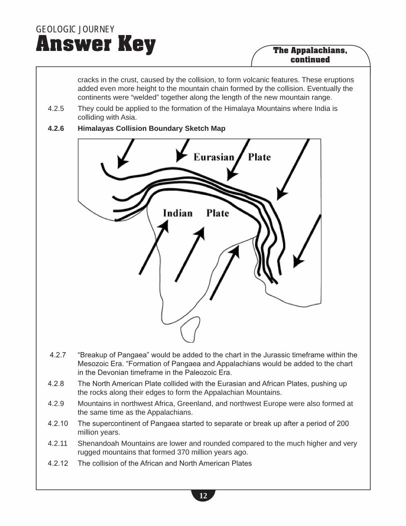
4.2.5 TheycouldbeappliedtotheformationoftheHimalayaMountainswhereIndiaiscollidingwithAsia.
4.2.6 Himalayas Collision Boundary Sketch Map
4.2.7 “BreakupofPangaea”wouldbeaddedtothechartintheJurassictimeframewithinthe
MesozoicEra.“FormationofPangaeaandAppalachianswouldbeaddedtothechartintheDevoniantimeframeinthePaleozoicEra.
4.2.8 TheNorthAmericanPlatecollidedwiththeEurasianandAfricanPlates,pushinguptherocksalongtheiredgestoformtheAppalachianMountains.
4.2.9 MountainsinnorthwestAfrica,Greenland,andnorthwestEuropewerealsoformedatthesametimeastheAppalachians.
4.2.10 ThesupercontinentofPangaeastartedtoseparateorbreakupafteraperiodof200millionyears.
4.2.11 ShenandoahMountainsarelowerandroundedcomparedtothemuchhigherandveryruggedmountainsthatformed370millionyearsago.
4.2.12 ThecollisionoftheAfricanandNorthAmericanPlates

The Appalachians, continued
GEOLOGIC JOURNEY
Answer Key
��
4.2.13 Evidenceincludes:foldedrocks,ancientfossilsfoundinsedimentaryrocksonmountaintops,lackofrocksofayoungeragethanthoseofthemountains,andalteredormetamorphosedrocksformedatgreatdepththatarenowfoundon,orverynear,thesurfaceoftheEarth.
Chapter 3: New Technologies, New Theories4.3.1 • Hypothesis–aproposedexplanationmadeonthebasisofavailableorlimited
evidenceandusedasaguidetofuturestudyorinvestigationtoproveitsaccuracyoracceptability.
•Theory–awidelyacceptedexplanationthathasbeenverifiedusingavailableandvalidatedevidence,anexplanationofeventsorprocessesthatbestfitsknownfacts.
4.3.2Case Study/Researcher
Hypothesis Technology In Use
Facts Collected Using Technology
Result of Hypothesis Testing
MontmorencyFalls–StephaneMazzotti
MovingapartoftheplatesalongSt.LawrenceValley
HighlyaccurateGPSequipment
Platesaremovingapartatafewmmperyear
Provesthatplatemovementcouldcauseearthquakesinfutureinthisregion
NewMadrid–MartitiaTuttle
Majorearthquakesoccurapproximatelyevery500yearsinsteadoftheformerlyaccepted1000yeartimeperiodintheNewMadridarea
Helicopterflight,radiocarbondating,
Dateswhensandblowsoccurred,indicatingmajorearthquakesintheregion
Provesthatthemajorquakesoccurapproximatelyevery500yearsonaverage
NorthCarolina/Newfoundland–JamesHibbard
Twomicroplates(CaroliniaandAvalonia)collidedwithNorthAmericatoformtheAppalachianMountainsinNorthCarolinaandNewfoundland
Lasertechnologytodatezircons
DatesofcollisiontoformmountainsinNCarolinaandNewfoundlandweredifferent
Provestwomicroplateswereinvolved,ratherthantheformerlyacceptedideathatonlyonemicroplatewasinvolved

The Appalachians, continued
GEOLOGIC JOURNEY
Answer Key
��
4.3.3. Itisreferredtoasatheory.4.3.4 Itismostlikelythatsometheorieswillbethrownoutorrevisedandthatnew
hypotheseswillbeproposedandprovenasaresultofnewevidenceobtainedthroughtheuseofnewandmoresophisticatedtechnologicaldevices.
Chapter 4: Want to be an Earth Scientist?4.4.1 Studentscouldsuggestawidevarietyofperceivedtraits,knowledge,andskills.
Accepttheiranswersifanacceptablejustificationisprovided.4.4.2 Therearenorightorwronganswerstothisquestion.Itisthediscussionthatprovides
studentswithabetterunderstandingofwhatittakestobeasuccessfulearthscientist.4.4.3 Thefirsttaskwastoproposepossibletraits,knowledge,andskillsbasedongeneral
knowledge.Thesecondtaskinvolvedtakingthemajortraits,knowledge,andskillssuggestedandinvestigatingthembygatheringevidencefromthevideo.Thethirdtaskwastotesteachhypothesistoseeifitwasverifiedorjustifiedbyevidencecollectedfromthevideo.Iftherewasevidencetosupportthehypothesis,itcouldbeconsideredatheory;ifnot,itwouldberejectedanddisregarded.
4.4.4 Themostimportantaspectofthisanswerwouldbeasetofreasonsthatwereclearlyoutlinedandwereconsistentwiththestudent’sposition.
Chapter 5: Earthquake Hazard4.5.1 Studentsarelikelytosuggestareasofrecentearthquakesinthenewssuchas
southeastAsia,Japan,Peru,California,etc.4.5.2 ThisanswerwillvarywiththeirlocationinCanada.ItisexpectedthatB.C.residents
wouldperceiveahigherearthquakeriskandmagnitudethanallbutafewstudentsfromtheSt.LawrenceValley,wherethequakeriskmightbeconsideredmoderateandthemagnituderatherlow.
4.5.3 Reboundislinkedcloselytothetheoryofisostasy.Whenthetermreboundisusedbygeologists,itreferstoariseinablockofEarth’scrustthatoccurswhenaweightisremovedfromitstoporsurface.ExampleswouldbeariseinthecentreoftheCanadianShieldasaresultofthemeltingofthecontinentalglaciersthatoncecovereditor,inthecaseofthisvideo,theremovalofthehigherpartsoftheoriginalAppalachianMountainsbyerosionoverthepast350+millionyears.Earthquakeswouldresultasthesereboundingblocksofthecrustmoveupwardsalongsurroundingrocks.
4.5.4 Suchquakesareoftenminorinmagnitudeanddisplacement.4.5.5 Theyaremostcloselyrelatedtomountainbeltsalongplateboundaries.4.5.6 TheLoganLineorFault4.5.7 Tuttleislookingforevidenceinthesoilsoftheregionfor“sandblows”.Thesefeatures
occurwhenundergroundsandlayersareliquefiedduringamajorearthquakeandmoveupwardsthroughcracksinthesoilcausedbythequaketoformsandfountainsorblows.Byfindinganddatingthesefeatures,Tuttleisabletodatepastmajor

The Appalachians, continued
GEOLOGIC JOURNEY
Answer Key
��
earthquakesintheNewMadridareathousandsofyearsintothepast.Herresearchindicatesmajorearthquakesoccurapproximatelyevery500years.
4.5.8 StudentsarelikelytogettheimpressionthattheearthquakehazardineasternNorthAmericaisratherhigh.
4.5.9 Makecertainstudentslookatbothmapstodeterminethemagnitudeofquakesintheircommunityaswellasthehazardlevel.
4.5.10 ThiswilldependonyourlocationwithinCanada.4.5.11 Tobeacceptable,theanswermustbesupportedbyaccurateandrelevantevidence
andalogicalexplanation.Thereisnorightorwronganswertothequestion.
The Atlantic CoastChapter 1: Tales from the Ocean Floor5.1.2 TheTablelandsarealeftoverfragmentofancientoceanfloorthatpre-datesthe
modernAtlanticOcean.WhenwhatgeologistsnowcalltheLapetusOcean(“fatherofAtlantica”)openedup,theserockswerenewly-formedonthatancientseafloor.WhenPangaeawasassembling,theserockshadacollisionwithwhatisnowtheAfricancontinent,andthisoldoceanfloorwasweldedontothenewsupercontinent.WhenPangaeabrokeupandanewoceanemerged(theAtlanticOcean),thissliceofoldoceancrustwasferriedacrosstheglobetobecomeapartofeasternNorthAmerica.
ThevolcanicrocksfoundintheTablelandsareknowntobeabundantonlyincertainseafloorsettings.Tohavethemavailableabovesealevelgivesusachancetowalkacrossanancientpieceofoceanfloorandcontinuewalkingrightdowntotheuppermantle.
5.1.3 Themineralwaschromite,whichismadeupofabouttwo-thirdschromiumoxide(Cr2O3)andone-thirdironoxide(FeO).Itisaheavy,resistantmineralthatcommonlyformsinEarth’suppermantleanddeepcrust.FindingchromitecrystalsinthesedimentaryrocksatLobsterCovewasunexpected.
5.1.4 • Thepresenceofchromiteindicatedthattherocksofthisareawerenotconventionaligneousrocks,buthadthehallmarksofbeingformedverydeepintheEarth–morethan25kmsdeep–asfardownasEarth’suppermostmantle.PlatetectonicforcesplacedtheTablelandsinthelocationwhereitisfoundtoday,andisactuallytheremnantofanoceanfloorthatonceseparatedNorthAmericafromAfricaandEurope.ThenewinterpretationisthattheTablelandsdidnotformwhereitistoday,buthadbeenbroughtthereafterajourneyspanning400millionyearsandtheopeningoftwooceans!
• ThesequenceofrocksinthispartofGrosMorneNationalParkiswhatisknownasanophiolitesequence,whichisageologist’stermforasectionofrocksthatrepresentsthetop30kmsofanoceanfloorsetting.Ophiolitestendtohavelavaflowsattheirtops,wheretherockswereformedattheoceanfloorwheretheymetthewater.Deeperdown,thevolcanicrockstendtobemadeupofveryiron-richminerals,areheavyfortheirsize.SincetheophioliteatGrosMornewastipped

The Atlantic Coast, continued
GEOLOGIC JOURNEY
Answer Key
��
upalmostverticallybytectonicforces,wecanliterallywalkfromthelavasoftheseafloorallthewayondowntotherocksoftheuppermantle.Imagineitasasliceoflayercakethathasfallenoveronitsside,andanantrunsacrossthelayers.WearethatantalongtheTablelands’trails.
5.1.5 ThefollowingWebsiteswillprovideinformationtocompletethisquestion:• This Dynamic Earth – the Story of Plate Tectonics http://pubs.usgs.gov/gip/dynamic/dynamic.html–Anintroductory-leveltreatmentofmostofthekeyideasandclassicalprinciplesoftheTheoryofPlateTectonics.ItalsoincludesalinktotheThisDynamicPlanetWebsitethatprovidesaweb-basedversionoftheinfluentialworldmapofglobaltectonics.
• Ophiolites http://volcano.und.nodak.edu/vwdocs/vw_hyperexchange/ophiolites.html–This
pagefromthepopularVolcanoworldWebsiteoutlineshowslicesofoceaniccrustcansometimesbethrustontothemarginsofcontinentsaslargeoceanbasinscloseupandcollisionofcrustalblocksoccurs.Itprovides“virtual”fieldtripstosomeoftheworld’smoreoutstandingexamplesofophiolites,includingthosefoundinOman,Cyprus,andNewfoundland.
• Gros Morne Adventures – Newfoundland Adventure Tourism http://www.grosmorneadventures.com/activities.html–Therelationshipsamong
geology,tourism,andtheactivelifestyleadvocatedtoday.
5.1.6 Sincethevolcanicrocksthatmakeupophiolitesareusuallybornatmid-oceanridges,itseemedsimpletoviewtheseslicesofoceanfloor/uppermantleasbeingpiecesof“fossil”spreadingcentres.Newermodelsactuallypointtoophiolitesformingatspreadingcentresveryclosetosubductionzones.Thismeansthattheyareleftstrandedwhenasliceoftheoceanfloorcollideswithacontinent.Studentsshouldfirstlookforareasoftheworldwherenewoceanfloorwilllikelybecreated,butquiteclosetoknownareaswheretheoceancrustislikelytobeconsumedataplateboundarythatisatrench.
ThemostlikelyplaceswherefutureophioliteswillbegeneratedwouldbealongthewestcoastofCanada(JuandeFucaplateboundary),thewestcoastofCentralAmerica,theRedSea/GulfofOman,andovermuchofthewesternmarginofthePacificPlate.

The Atlantic Coast, continued
GEOLOGIC JOURNEY
Answer Key
��
5.1.7 Geology of the Tablelands, Gros Morne National Park, Newfoundland

The Atlantic Coast, continued
GEOLOGIC JOURNEY
Answer Key
��
Chapter 2: Experiment in the Precambrian Oceans5.2.3 Thesefossilizedcreaturesrepresentaveryearlyexampleofwhathasbeencalled
“metazoan”lifeforms,meaningtheywerelarge,multi-cellular,andwouldbeeasilyvisibletotheeye.Priortotheirexistence,anypreviously-knownorganisms—suchasblue-greenalgaeandbacteria—weremicroscopicinsize.
Thebodyplansoftheseorganismshavenomodern-daycounterparts,nordidtheyexistmuchbeyondthebeginningoftheCambrianperiod.Thismakesthemasortof“niche”collectionthatisatypeof“experimentatlifegettingbig”asProfessorJimGehlingputsitinthisepisodeofGeologicJourney.
5.2.4 ThesefossilsoccurinrocksthatwereoncesittingrightnexttoAfricaandthenwere“brought”totheircurrentlocationaspartofa“geologicjourney”astheAtlanticOceanopenedupfollowingthebreakupofPangaea.Whenthefieldpartyreachedaparticularoutcroppingofthefossils,everyonewasaskedtoremovetheirfootwearinordertonotharmthesurfaceoftherocksthatcontainedtheimpressions.ThereareveryfewplacesintheworldwhereEdiacaran-ageanimalfossilsoccurinsuchabundance;MistakenPointisararefindforpaleontologists,andhasbeenvisitedbyinterestedpeoplefromaroundtheworld
5.2.5 Thediamondreferencespeakstosomethingasbeingrare,valuable,difficulttofind,occurringonlyinafewselectareasonEarth,beautifultotheeyeofthebeholder.ThesethoughtscanthenbemadeanalogoustothefossilsatMistakenPoint,whichareimpressionsofrareanimals,holdgreatsignificancetothegeologichistoryofEarth,andalsohaveacertainbeautyaboutthemamongthosepeoplewhoappreciatetheirexistenceandimportance.
5.2.6 • AccordingtotherecreationsseeninGeologicJourney,theseanimalswere“sessile”,ie.attachedtotheseabottombyasortofholdfast,oranchor,structure.Themannerinwhichtheydiedsuggeststhatsmall,localized“gardens”ofEdicarananimalslivedincloseproximitytooneanother.Sincenonehadjaws,teeth,mobility,oradigestivesystemandwereallfilterfeeders,predationwaslikelynotoccurringatall.Theseanimalslivedalongashallow-waterslopeadjacenttoanoceanshoreline,butsincetheyarepreservedamongshales(arocktypecharacteristicofdepthsbelowwheresunlightpenetrates),itseemsthattheylivedincompletedarknessallthetime.
• TheMistakenPointcollectioniscappedontopbyathicklayerof“tuff”(hardenedvolcanicash).Thisindicatesthatthisparticularlocationwasonceunderthedirectinfluenceofactivevolcanoes.Thoughtheeruptionitselfwouldnothavebeenfataltothem,thevolcanicashrainingdownontheseawouldhavedriftedtothebottomandcoveredthem.
5.2.7 TheWardfamily,livingclosetothefossilbeds,recognizethattheyhaveanimportantvolunteerroleinassistinginthepreservationofthisuniquesite.Oneparticularanimalspeciesamongthecollectionbearsthefamilyname,andwasfirstdiscoveredbyMrs.Ward’sson.
5.2.8 HumansconstitutetheonlyknowntechnologicalspeciesinEarthhistory.Weactuallyhavetheabilitytoeliminateourselvesratherthanbeextinguishedbymorenaturalmeans.Itwouldbeinterestingtodiscover–fromstudents’views–whetherthismakesusaparticularlyfragilespeciesthatisperhapsthemostuniqueexperimentyetinlifeonEarth.
The Atlantic Coast, continued
GEOLOGIC JOURNEY
Answer Key
��
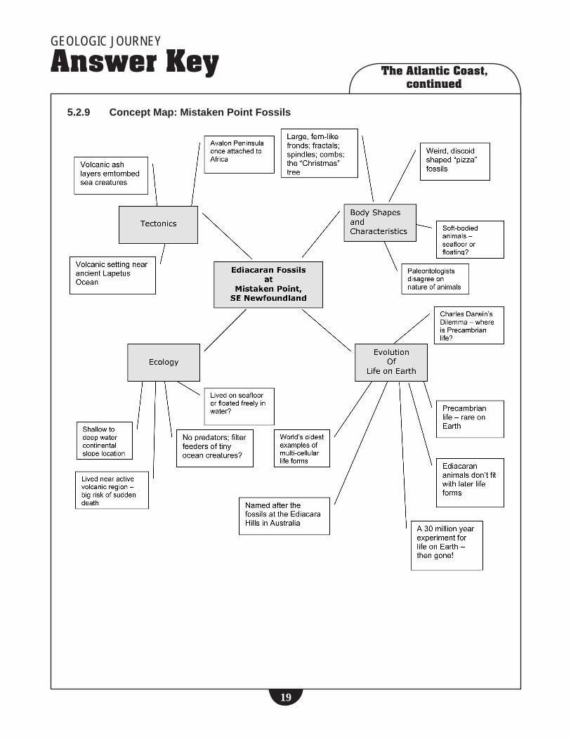
5.2.9 Concept Map: Mistaken Point Fossils
The Atlantic Coast, continued
GEOLOGIC JOURNEY
Answer Key
�0
Chapter 3: Mass Extinction….and Something New Out of Africa5.3.1–5.3.4 Researchingscientificinformationforaprojectinvolvesdifferentskills,thinking,
andkeywordapproachesthanlookingupamovietrailer,afavouritemusician,orsports-relatedinformation.
Usingavarietyofsearchenginesthatstudentscanidentifyandhaveused(Yahoo,Infoseek,Google,Dogpile,Yahooligans,AskJeeves,AltaVista,RagingSearch,etc.),havestudentssearch“massextinctions”,oranyothertopicrelatingtoanepisodeofGeologicJourney.Recordresultsoffindingsforeachsearchengineonaclasschartortable,notingthekeywordsearchterm(s),thenumberofhitsobtained,theorganizationofhits(e.g.,groupedbysearchenginetype,ratingsinpercentages,etc.)
Dotheresultsobtainedbyeachstudentmatchtheiroriginalpredictions?Howdotheresultscomparefordifferentsearchengines?Discusspossiblereasonsforthedifferencesbetweentheirpredictionsandactualresults,andbetweenthedifferentsearchengines.
Answerswillvary,butcharacteristicssuchastheeasilyvisiblesedimentarycharacteroftherocks(clearbedding),theabundanceoffossils,actionofthelocaltides,heightofthecliffs,shouldemerge.
5.3.6 EldonGeorgehasknowntheareasincehewasachild,andhiskeeninterestinrocks,mineralsandfossilsstemsfromhishavingincurredanarminjurythatdidnothealcompletely.Thiskepthimawayfromtheactivitiesmostofthelocalboysengagedinwhilehewasyoung.Hehasbeencollectingfordecades,andhashadthetimetospendovertheyearswiththisfossil-richarea.Eldonhasparticularknowledgeofthecrocodile-likeorganisms,andrecognizesthedinosaurfootprintswithaneyeasgoodasthatofanypalaeontologist.PerhapsthegreatestcontributionhemakesisthroughdiscussionswithvisitorstotheareapromotingtheimportanceofunderstandingancientlifeonEarth.
5.3.7 Thegeologicandscientificinterestiswiththeageoftherocksthatcontainthefossils.OnemajorextinctionepisodeoccurredatthetransitionfromtheTriassictotheJurassicperiods.ParrsboroBeachhasrocksthatdatepreciselytothistimeboundary.Therefore,the“richtreasure”isallaboutunderstandingwhatsortsofanimalsdidanddidn’tsurvivetheextinctionevent.TheParrsbororockscontainthefossilremainsoftheanimalsthatrepopulatedtheplanetfollowingtheextinctionthateliminatedmorethanhalfoftheworld’sspecies(accordingtothefossilevidence).Thesmall,mammal-sizedreptilesfoundatParrsboroweretheprecursorstothegreatgiantreptilesthat“ruled”thepredatorworldintheJurassicPeriodthatfollowedsometimelater.
5.3.8 Dr.PaulOlsenandDr.JessicaWhitesidearetestinganideathatthereisaconnectionamongsuper-continentbreakup(Pangaeainthisinstance),volcanicactivity,andlarge-scaleextinctionevents.Theriftingapartoflargeblocksofcrustisaccompaniedby,orperhapsevendrivenby,significantperiodsofigneous(volcanic)activity.Theincreasedvolcanismmaythencausedramaticclimaticdisruptionwhichleavesvulnerableorganismsatriskduetolossofhabitat,scarcityoffood,lowerlevelsofsunlight,andevenglobalcooling.TheirrecentworkhasbeenunabletoestablishaclearconnectionbetweenthevolcanicoutpouringsintheNorthAtlanticregionattheendoftheTriassicPeriodandthetimingoftheextinctionevent.Moreworkneedsto

The Atlantic Coast, continued
GEOLOGIC JOURNEY
Answer Key
��
bedonetotestthishypothesis.Dr.Whitesideusestheratiooftwostableisotopes(meaningnon-radioactive)ofcarbon–carbon-13andcarbon-12–asameansofdeterminingthetypeofatmosphericenvironmentthatorganismslivedinlongago.
Weusecarbonisotopedataforexactlythesamereasonthatweuseoxygenisotopedata–tofindoutfromwheretheatomsinaspecificobject(e.g.,ananimalorplant)arederivedandwhattheirhistoryhasbeen.Thehistoryofcarbonatomsinlivingorganismsinvolveshowtheorganismsobtainedthesecarbonatoms.Forplantsthismeanshowtheirphotosyntheticreactionsworked;foranimals,whattheyhavebeeneating.Carbonisotopicrecordsincarbonaterocksareofinteresttopaleo-ecologistsbecausetheyhelpunderstandthefunctioningofthecarboncycleduringearthhistory,andthroughthecarboncycle,thehistoryofthebiosphere.
WhatDr.Whitesideishopingtoderivefromthecarbonisotope“fingerprints”inthecarbonaterocksandfossilsoftheAtlasMountains(asseeninGeologicJourney)iswhetherthereisanyevidenceofadeviationfrom“normal”photosynthesisinplants,orsomesortofabigdisruptionintheglobalcarboncycle.Disruptionsinthecarboncyclecouldbeasignalofsomesortofglobalcatastrophethatwouldexplainthemassextinctionevent.
5.3.9 Humanity’sincreasingpopulationanddemandfornaturalresourcesmakesuspotentiallyanunsustainable,almostpredatory,speciesonthisplanet.ByvirtueofthelargeamountsofCO2weproducethroughburningfossilfuels,humansmayeventuallybecontributorstochangesintheworld’scarboncycling.ThatmakesusapotentialgeologicalforcethatcouldendupcontributingtoyetanotherlargeextinctioneventonplanetEarth.
5.3.11OnlineinformationabouttheendTriassicextinctionevent(especiallyteacherbackgroundorformotivatedstudents)canbefoundat:
• www.uky.edu/KGS/education/EndTriassic.htm
• en.wikipedia.org/wiki/Triassic-Jurassic_extinction_event
• palaeo.gly.bris.ac.uk/Palaeofiles/Triassic/triextict.htm
• www.space.com/scienceastronomy/planetearth/jersey_dinosaurs_020516-1.html
• www.space.com/scienceastronomy/planetearth/extinction_permian_000907.html


