In arable valleys of water-limited regions worldwide, community water management systems have evolved to sustain communities in the face of unreliable precipitation. The acequias of the southwestern United States lie at the center of a set of complex self-maintaining interactions between culture and nature that appear to enable drought survival and maintain other sociocultural and ecosystem benefits. Local water management groups inherent in acequias ensure equitable distribution of water to each community, allocating less water for all users in dry years and more in wet years. Acequias help maintain community identity and cohesion, economic sustainability, enhanced floodplain hydrologic function, and wildlife habitat. Contemporary acequia-based communities face new socioeconomic and natural resource pressures that threaten their existence, however. Population growth is accelerating the change from agricultural to residential land and water uses, while climate change threatens to bring warmer winters with less precipitation and earlier spring snowmelt. Traditional acequias create and sustain intrinsic linkages between human and natural systems that increase community and ecosystem resilience to climatic and socioeconomic stresses. Greater knowledge about these interconnections and what can cause them to change or fail will be essential to determine how the communities relying on acequias can adapt to changing conditions. This interdisciplinary research project will explore socioeconomic and cultural linkages within and between acequia communities and associated landscapes; hydrologic linkages between surface water and groundwater in irrigated river valleys and contributing watersheds; and wildlife habitat and grazing distribution connections between valley riparian areas and upland forests and grasslands. The investigators will quantify the role of acequias in hydrologic function, community resilience, and ecosystem health, and they will identify potential tipping points for acequia community survival. Integrative tools informed by examinations of socioeconomic, cultural, and ecohydrological factors will indicate the resilience level of acequia-centered systems. A system dynamics model will simulate effects of climate and land-use stressors on relationships between economic, social, cultural, climatic, hydrologic, vegetation, and wildlife components. The model will quantify the magnitude of stressors needed to undermine community and ecosystem resilience. Mapping will capture spatial linkages and help communicate the findings to a larger audience. This project will provide new insights into the relationships between traditional water management systems, communities, and landscapes.
Field data collection:
Study sites:
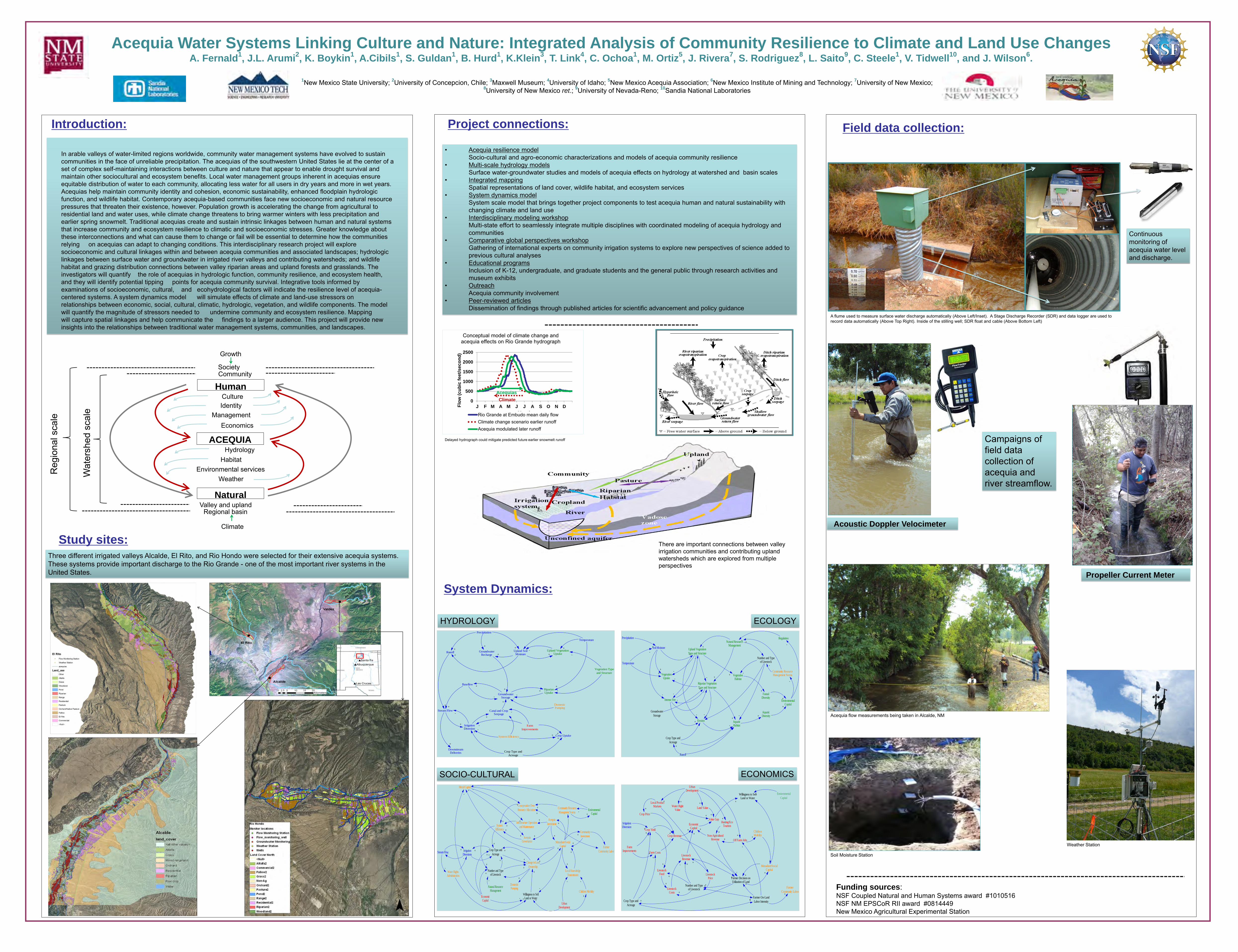
Human
ACEQUIA
Natural
Climate
Regional basin
Community
Growth
Society
Economics
Identity Management
Hydrology Habitat
Environmental services Weather
Valley and upland
Culture
Reg
iona
l sca
le
Wat
ersh
ed s
cale
• Acequia resilience model Socio-cultural and agro-economic characterizations and models of acequia community resilience • Multi-scale hydrology models Surface water-groundwater studies and models of acequia effects on hydrology at watershed and basin scales • Integrated mapping Spatial representations of land cover, wildlife habitat, and ecosystem services • System dynamics model System scale model that brings together project components to test acequia human and natural sustainability with
changing climate and land use • Interdisciplinary modeling workshop Multi-state effort to seamlessly integrate multiple disciplines with coordinated modeling of acequia hydrology and
communities • Comparative global perspectives workshop Gathering of international experts on community irrigation systems to explore new perspectives of science added to
previous cultural analyses • Educational programs Inclusion of K-12, undergraduate, and graduate students and the general public through research activities and
museum exhibits • Outreach Acequia community involvement • Peer-reviewed articles Dissemination of findings through published articles for scientific advancement and policy guidance
Acequia flow measurements being taken in Alcalde, NM
Project connections:
System Dynamics:
Funding sources: NSF Coupled Natural and Human Systems award #1010516 NSF NM EPSCoR RII award #0814449 New Mexico Agricultural Experimental Station
1New Mexico State University; 2University of Concepcion, Chile; 3Maxwell Museum; 4University of Idaho; 5New Mexico Acequia Association; 6New Mexico Institute of Mining and Technology; 7University of New Mexico; 8University of New Mexico ret.; 9University of Nevada-Reno; 10Sandia National Laboratories
Acequia Water Systems Linking Culture and Nature: Integrated Analysis of Community Resilience to Climate and Land Use Changes A. Fernald
1, J.L. Arumi
2, K. Boykin
1, A.Cibils
1, S. Guldan
1, B. Hurd
1, K.Klein
3, T. Link
4, C. Ochoa
1, M. Ortiz
5, J. Rivera
7, S. Rodriguez
8, L. Saito
9, C. Steele
1, V. Tidwell
10, and J. Wilson
6.
A flume used to measure surface water discharge automatically (Above Left/Inset). A Stage Discharge Recorder (SDR) and data logger are used to record data automatically (Above Top Right). Inside of the stilling well; SDR float and cable (Above Bottom Left)
Continuous monitoring of acequia water level and discharge.
There are important connections between valley irrigation communities and contributing upland watersheds which are explored from multiple perspectives
0
500
1000
1500
2000
2500
J F M A M J J A S O N DFlo
w (
cu
bic
fe
et/
se
co
nd
)
Month
Conceptual model of climate change and acequia effects on Rio Grande hydrograph
Rio Grande at Embudo mean daily flowClimate change scenario earlier runoffAcequia modulated later runoff
Climate
Acequias
Delayed hydrograph could mitigate predicted future earlier snowmelt runoff
Three different irrigated valleys Alcalde, El Rito, and Rio Hondo were selected for their extensive acequia systems. These systems provide important discharge to the Rio Grande - one of the most important river systems in the United States.
Runoff
Stream Flow
DownstreamDeliveries
IrrigationDiversion
DomesticPumping
Precipitation
GroundwaterRecharge
Upland SoilMoisture
Upland VegetationUptake
Temperature
RiparianUptake
GroundwaterStorage
Baseflow
Canal and CropSeepage
++
+
++
+ +-
++
+
+
+
+
+
--
-
+
+
-
-
+
Crop Type and
Acreage
Farm
Improvements
Crop Uptake+
++
-
-
Vegetation Type
and Structure
-
-
System Efficiency
-
+
-
VegetativeHabitat
FaunalDiversity
Erosion AquaticHabitat
AquaticDiversity
Runoff
Number and Typeof Livestock
Upland Vegetation
Type and Structure
+
+
+
+
-
Precipitation
Soil Moisture
VegetationUptake
+
+
Temperature
+
-
Riparian Vegetation
Type and Structure
--
Intense Fire -
--
-
+
Natural ResourceManagement
-
-
+
EnvironmentalCapital
+
+
Regulation
Community ResourceManagement Norms
-
-+
-
+
+
+
-
-
+
+
-
-
Crop Type and
Acreage
Groundwater
Storage
+
+
Stream Flow IrrigationDiversions
Water RightsAdministration
UrbanDevelopment
Natural ResourceManagement
Number and Typeof Livestock
Crop Type and
Acreage
SystemEfficiency
Coooperation Over
Resource Allocation
Infrastructure Operation
and Maintenance
Mutualism/SocialCapital
AcequiaGovernance
Change in Land
OwnershipLocal Knowledge
Transmission
+
-
-
+
+
+
+
-
+
+
+
+
+
+
+
+
-
+
+
+
DomesticPumping
+
-
Willingness to SellLand or Water
+
Acequia
Investment
Community
Investment
+
+
+
+
+
+
+
Community Resource
Managment Norms
+Environmental
Capital-
++Economic
Capital-
+
+
-Children Mobility
+
-
+
Farmer
Community Labor
Moral Capital
-
-+
+
+
+
EconomicCapital
UrbanDevelopment
Local ProductMarkets
Crop Price
Crop Yield
Farm Costs
FarmImprovements
IrrigationDiversion
LivestockFeed
Number and Typeof LivestockLivestock
Costs
LivestockPrice
Hunting/EcoTourism
Off Farm Jobs
ChildrenMobility
Willingness to SellLand or Water
Water RightValue
Land Value
Value Gap
+
++
-
+++
+
Crop Type and
Acreage
+
++
+
+
+
+
+
+
+
+
+
+
LivestockRevenue
++-
Crop Revenue-
++Non-Agricultural
Revenue
+
+
++
+
Farmer Decision onUtilization of Land
+
-
+
+
+
Mutualism/SocialCapital
++
Enviornmental
Capital-
Farmer On-Land
Labor Intensity+
-
+
+
Farmer
Community Labor+
HYDROLOGY ECOLOGY
SOCIO-CULTURAL ECONOMICS
Acoustic Doppler Velocimeter
Campaigns of field data collection of acequia and river streamflow.
Weather Station
Soil Moisture Station
Introduction:
Propeller Current Meter


