Alpine Shire Council Rural Land Strategy – Final April 2015
27
Rural precincts 1.5
Eight distinct precincts have been identified in the rural areas of Alpine Shire, each being
identified due to a range of differing land use, locational characteristics, agricultural
productivity and land use pressures. The precincts are identified in the following map. This
section outlines an assessment and recommendations for each precinct. For further details
on each rural precinct, reference should be made to the background report for this strategy.
Map 3 identifies the rural precincts identified in this study.

Alpine Shire Council Rural Land Strategy – Final April 2015
28
Map 3: Rural Precincts in the Alpine Shire (Source: Alpine Shire Council)

Alpine Shire Council Rural Land Strategy – Final April 2015
29
1.5.1 Introduction, rural precincts:
Characteristics for all precincts form part of the significance of Alpine Shire for agricultural
production, tourism and landscape. All precincts have a need to protect agricultural land
and the natural environment. All precincts offer opportunities for the further diversification
of agriculture and tourism.
While the rural precincts share common values, needs and opportunities, precincts also
include distinct characteristics, needs and opportunities unique to each area. These precinct
specific issues require specific actions and responses for individual precincts. Community
consultation for this strategy has guided the required responses and actions for each
precinct.
Further assessment, opportunities and detailed recommendations for each precinct are
outlined in the background report for this strategy. This background report guides future
land use in precincts, identifying further detailed needs and potential in each precinct.
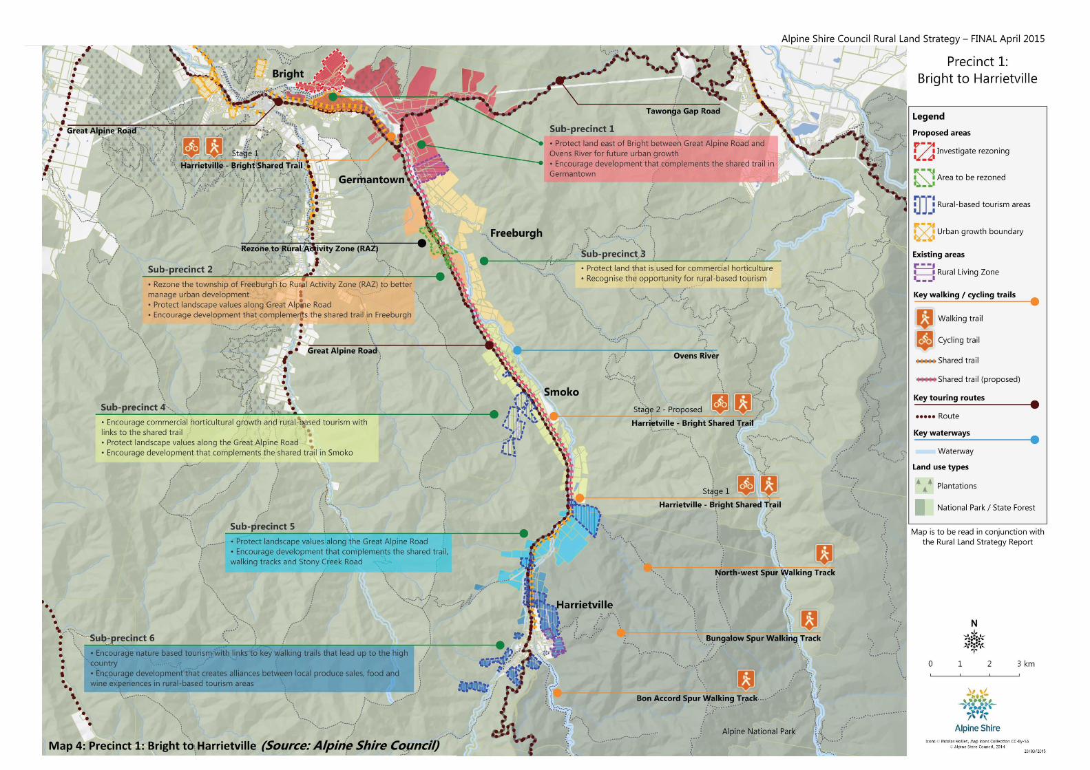
1.5.2 Precinct 1 – Bright to Harrietville:
The Bright to Harrietville Precinct is characterised by a flat to gently undulating narrow valley
floor though which the Ovens River meanders. The sides of the valley rise sharply into the
Alpine National Park to the east and the state forest to the west.
Subdivision and dwelling pressures are apparent in the precinct.
While the valley is not renowned for commercial agricultural production, there is opportunity
to improve the agri-tourism experience by promoting the ‘farm to plate’ and ‘pedal to
produce’ experience with links to the shared bike path. There is also opportunity to expand
nature based tourism in areas fragmented from agriculture.
Tourism alliances should be built around key attractions such as walking trails, the Ovens
River and local produce sales and food and wine experiences.
Alpine Shire Council Rural Land Strategy – FINAL April 2015
Map 4: Precinct 1: Bright to Harrietville (Source: Alpine Shire Council)


