download a pdf of our interactive brochure
TRANSCRIPT

Training Consultancy Research & Development Testing Education
GRACE is located in the Nottingham Geospatial Building (NGB) within the University of Nottingham Innovation Park (UNIP) – a 15 acre site with initial development capacity for 20,000 sq.m.
The NGB provides flexible accommodation solutions for start-ups, entrepreneurs and project offices. We welcome applications from ambitious companies and individuals that are operating or developing businesses within GNSS and Geospatial related application and development domains. We can offer single desk space in a shared office as well as serviced offices of up to 36m2. For those companies that are not ready for a physical presence in our facility we also offer a very cost-effective virtual-presence option with a NGB company address.
More than just an office ….With a presence in the Nottingham Geospatial Building you will be alongside some of the most exciting individuals operating in the GNSS domain in the UK. You will have the opportunity to have direct access to some of the leading academics and researchers at the University of Nottingham and participating in the University’s ambitious technology transfer programme. We operate a vibrant and inclusive business incubation service that includes regular coffee mornings and networking events and access to business development, legal, accountancy, funding and technical experts.
Our facilities include;
Cutting edge IT and telecoms technology, including AV equipment
High speed internet access, photocopiers and printers
Customised signage and office branding
Meeting, conference, training rooms and development
labs for hire
Other benefits include;
Flexible working arrangements – take as much space as you need for as long as you need
Significant cost savings with no capital investment
Extra space and grow-on space available
University of Nottingham Innovation Park
Set on a 15-acre site, with initial development capacity for 20,000 m2 next to the award-winning Jubilee campus, the University of Nottingham Innovation Park (UNIP) opened in 2008. The aim is to provide excellent business accommodation and encourage innovation by providing the bridge between the corporate and academic worlds.
UNIP provides businesses with a close geographic proximity to University research and technical facilities, alongside other innovative businesses.
• World renowned Science Park • A hub of knowledge intensive innovative businesses• 1800m2 lettable space• High quality conferencing space and facilities
www.unip.org.uk
For more information please contact
t: +44 (0) 115 823 2333
f: +44 (0) 115 951 3881
w: www.grace.ac.uk
Business Incubation
Integrated Positioning Test Vehicle
GNSS Simulator
Test Track
GNSS Training Services
GNSS Testing and Simulation
➔
➔
➔
➔
➔
➔
supported by
➔➔BUSINESS INCUBATION➔
GPS52° 57´ 06.64˝N, 001° 11´ 01.90˝W
www.grace.ac.uk

Training Consultancy Research & Development Testing Education
GRACE is part of the IESSG at the University of Nottingham based in the Nottingham Geospatial Building and provides access to a dedicated integrated positioning vehicle that is capable of centimetre level positioning solutions in a variety of environments.
This vehicle is fitted with navigation equipment and onboard PCs that provide a facility to determine real-time or post-processed ‘truth’ trajectories for testing other navigation sensors. These other sensors can also be integrated into the positioning solution. Integrated data logging allows additional data streams, such as video images or laser scan point clouds, to be tagged with precise position and time information.
With these capabilities, the vehicle will satisfy a wide range of location-based testing applications, such as road condition monitoring, road user charging schemes, urban modelling, automated speed control, and any other applications that require a reliable and continuous, real-time, centimetre-level positioning accuracy.
Typical data sources include:
• GNSS
• Inertial Measurement Units (IMU)
• eLORAN
• Network Real Time Kinematic (NRTK) GNSS
Research areas:
• Provision of truthing solutions
• Geocoding still and video imagery
• Asset mapping
• Urban modelling
• Network RTK
• Laser scanning
For more information please contact
t: +44 (0) 115 823 2333
f: +44 (0) 115 951 3881
w: www.grace.ac.uk
Business Incubation
Integrated Positioning Test Vehicle
GNSS Simulator
Test Track
GNSS Training Services
GNSS Testing and Simulation
➔
➔
➔
➔
➔
➔
supported by
➔➔INTEGRATED POSITIONING TEST VEHICLE
GPS52° 57´ 06.64˝N, 001° 11´ 01.90˝W
www.grace.ac.uk
➔
CASE STUDY“The IESSG Van was used as a mobile test lab in an EU project: SISTER (Satcoms in Support of Transport on European Roads). A variety of kinematic tests were carried out in the East Midlands area from Dec 2008 to July 2010.
Tests included testing the signal reception of the cell phone network and different communication satellites, and assessing their impact to the high accuracy real time positioning on the road. The van was also driven to Paris to test the performance of a specific satellite, Solaris, which is only available in Paris.”

Training Consultancy Research & Development Testing Education
For more information please contact
t: +44 (0) 115 823 2333
f: +44 (0) 115 951 3881
w: www.grace.ac.uk
Business Incubation
Integrated Positioning Test Vehicle
GNSS Simulator
Test Track
GNSS Training Services
GNSS Testing and Simulation
➔
➔
➔
➔
➔
➔
supported by
➔➔GNSS TRAINING SERVICES➔
GPS52° 57´ 06.64˝N, 001° 11´ 01.90˝W
www.grace.ac.uk
Module timetableModule and description ES&G GNSST P&NT
2010 Autumn term
27 Sep - 01 Oct Fundamentals of Satellite Positioning Core Core Core
11 Oct - 15 Oct Analytical Methods Core Core Core
01 Nov - 05 Nov Geodetic Reference Systems Core Core Core
15 Nov - 19 Nov Terrestrial-based Positioning Core Core
22 Nov - 26 Nov Engineering Surveying Core
2011 Spring term
31 Jan - 04 Feb Photogrammetry and Remote Sensing Core
14 Feb - 18 Feb Advanced Satellite Positioning Core Core Core
28 Feb - 04 Mar Satellite Positioning System Design Core Core
07 Mar - 11 Mar Physical Geodesy Core
14 Mar - 18 Mar Navigation Systems & Integration Core Core
10 Apr - 16 Apr * Practical Field Course/ Survey Field Course Core Core Core
Key GNSST = GNSS Technology, ES&G = Engineering Surveying & Geodesy, P&NT = Positioning & Navigation Technology
Engineering Surveying & Space GeodesyCode Qualification Title HEU Fees International Fees ELQ ExemptH24C MSc GNSS Technology £4,480 £14,260
H24D PGDip GNSS Technology £4,480 £14,260
H24A MSc Positioning & Navigation Technology £4,480 £14,260
H24B PGDip Positioning & Navigation Technology £4,480 £14,260
H243 MSc Engineering Surveying and Geodesy £4,480 £14,260
H244 PGDip Engineering Surveying and Geodesy £4,480 £14,260
HF2X MSc Environmental Management and Earth Observation
£4,480 £14,260
HF2Y PGDip Environmental Management and Earth Observation
£4,480 £14,260
Current fees Standard modular course for practioners fee is £825 per person per week.
Please note that the Engineering Surveying & Geodesy MSc course includes a compulsory residential field course module, with additional costs of around £300.
Group discounts are available on request
GRACE is part of the IESSG at the University of Nottingham and provides a gateway to some of the most highly valued GNSS related courses and qualifications that are available today. The IESSG offers a range of training options that are open to professionals who are keen to develop their knowledge of GNSS. They operate a schedule of modules that also form part of a taught MSC programme which runs annually from September to April.
Courses for practitionersMany of the modules can be taken individually. Previous participants have found the short courses useful for updating existing knowledge, as continuing professional development (CPD), or expanding into a new area of expertise. The IESSG also offers courses that are tailored to your requirements. This could be anything from a half day seminar on your premises to a 2 week course delivered at a location of your choice.
Modules are taught intensively over a 5 day week at the Nottingham Geospatial Building providing you with sound up-to-date knowledge and practical experience. Each course consists of printed lecture materials, lectures from in-house and other experts, with many involving practical hands-on sessions using an expansive range of modern equipment and data processing packages. Courses are typically non-examined and you will receive an accredited certificate on completion of the course from one of the highest regarded institutes operating in the field of GNSS in the world.
Modular courses currently available
Fundamentals of Satellite Positioning
Advanced Satellite Positioning
Satellite Positioning System Design
Engineering Surveying
Photogrammetry and Remote Sensing
Navigation Systems and Integration
Terrestrial-based Positioning
The IESSG also offers courses that provide mathematical, statistical, coordinate system and geodetic knowledge that underpin and augment the learning gained from the modules above:
Analytical Methods
Geodetic Reference Systems
Physical Geodesy
Current MSc Courses
GNSS Technology (GNSST)
Positioning & Navigation Technology (PNT)
Engineering Surveying and Geodesy (ESG)
Environmental Management and Earth Observation (EMEO)
All courses benefit from the wide range of research undertaken at the Institute, and from expertise brought in from industry, the armed forces and other academic departments.
Training Consultancy Research & Development Testing Education
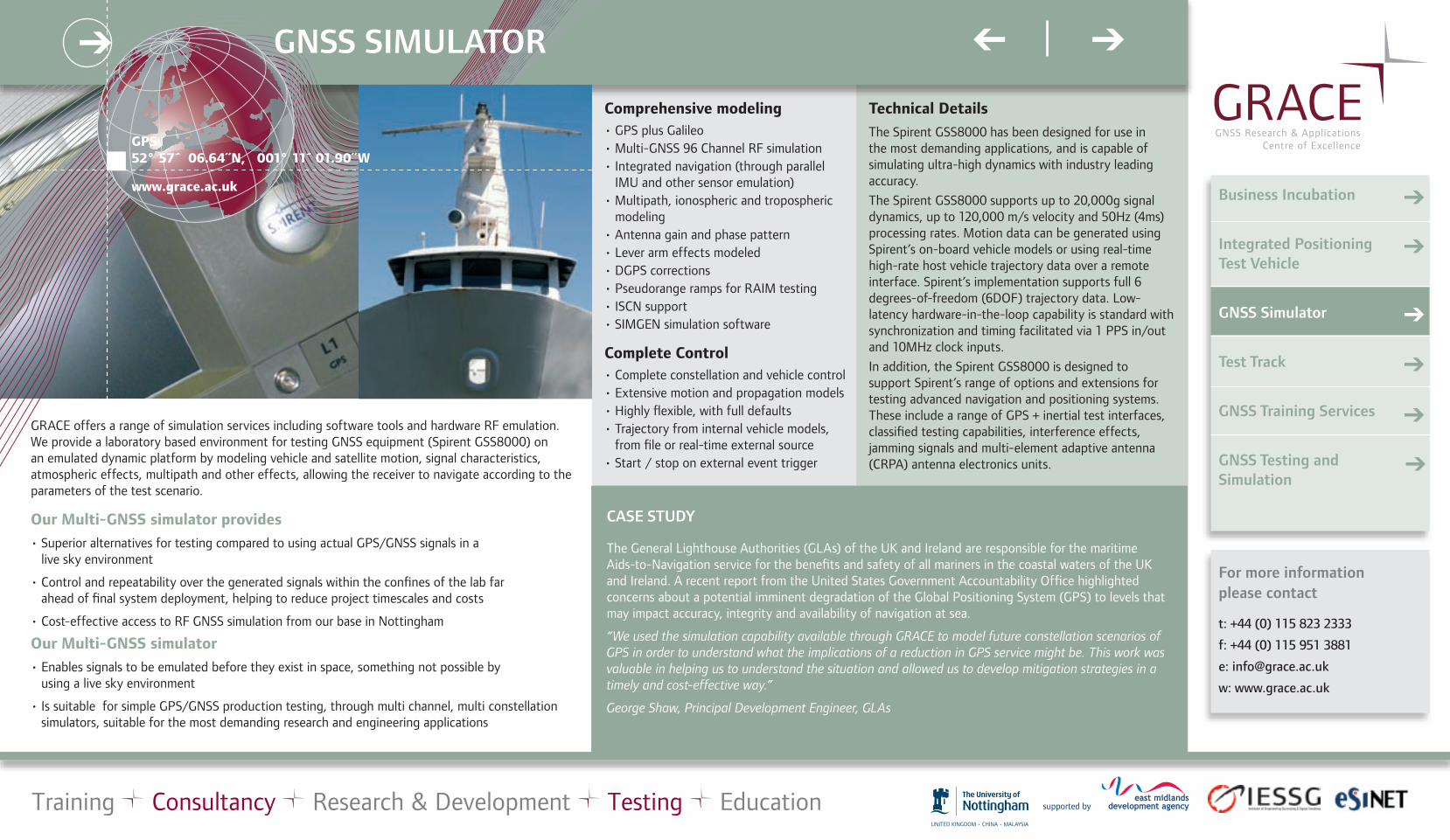
GRACE offers a range of simulation services including software tools and hardware RF emulation. We provide a laboratory based environment for testing GNSS equipment (Spirent GSS8000) on an emulated dynamic platform by modeling vehicle and satellite motion, signal characteristics, atmospheric effects, multipath and other effects, allowing the receiver to navigate according to the parameters of the test scenario.
Our Multi-GNSS simulator provides
• Superior alternatives for testing compared to using actual GPS/GNSS signals in a live sky environment
• Control and repeatability over the generated signals within the confines of the lab far ahead of final system deployment, helping to reduce project timescales and costs
• Cost-effective access to RF GNSS simulation from our base in Nottingham
Our Multi-GNSS simulator
• Enables signals to be emulated before they exist in space, something not possible by using a live sky environment
• Is suitable for simple GPS/GNSS production testing, through multi channel, multi constellation simulators, suitable for the most demanding research and engineering applications
Comprehensive modeling• GPS plus Galileo• Multi-GNSS 96 Channel RF simulation• Integrated navigation (through parallel
IMU and other sensor emulation)• Multipath, ionospheric and tropospheric
modeling• Antenna gain and phase pattern• Lever arm effects modeled• DGPS corrections• Pseudorange ramps for RAIM testing• ISCN support• SIMGEN simulation software
Complete Control• Complete constellation and vehicle control• Extensive motion and propagation models• Highly flexible, with full defaults• Trajectory from internal vehicle models,
from file or real-time external source• Start / stop on external event trigger
For more information please contact
t: +44 (0) 115 823 2333
f: +44 (0) 115 951 3881
w: www.grace.ac.uk
Business Incubation
Integrated Positioning Test Vehicle
GNSS Simulator
Test Track
GNSS Training Services
GNSS Testing and Simulation
➔
➔
➔
➔
➔
➔
supported by
➔➔GNSS SIMULATOR
Technical Details
The Spirent GSS8000 has been designed for use in the most demanding applications, and is capable of simulating ultra-high dynamics with industry leading accuracy.
The Spirent GSS8000 supports up to 20,000g signal dynamics, up to 120,000 m/s velocity and 50Hz (4ms) processing rates. Motion data can be generated using Spirent’s on-board vehicle models or using real-time high-rate host vehicle trajectory data over a remote interface. Spirent’s implementation supports full 6 degrees-of-freedom (6DOF) trajectory data. Low-latency hardware-in-the-loop capability is standard with synchronization and timing facilitated via 1 PPS in/out and 10MHz clock inputs.
In addition, the Spirent GSS8000 is designed to support Spirent’s range of options and extensions for testing advanced navigation and positioning systems. These include a range of GPS + inertial test interfaces, classified testing capabilities, interference effects, jamming signals and multi-element adaptive antenna (CRPA) antenna electronics units.
The General Lighthouse Authorities (GLAs) of the UK and Ireland are responsible for the maritime Aids-to-Navigation service for the benefits and safety of all mariners in the coastal waters of the UK and Ireland. A recent report from the United States Government Accountability Office highlighted concerns about a potential imminent degradation of the Global Positioning System (GPS) to levels that may impact accuracy, integrity and availability of navigation at sea.
“We used the simulation capability available through GRACE to model future constellation scenarios of GPS in order to understand what the implications of a reduction in GPS service might be. This work was valuable in helping us to understand the situation and allowed us to develop mitigation strategies in a timely and cost-effective way.”
George Shaw, Principal Development Engineer, GLAs
CASE STUDY
GPS52° 57´ 06.64˝N, 001° 11´ 01.90˝W
www.grace.ac.uk
➔

Training Consultancy Research & Development Testing Education
GRACE offers a unique and comprehensive environment for testing GNSS applications, services and products.Our facility, within the Nottingham Geospatial Building provides expert capability and state of the art equipment to support GNSS open sky, simulated and multi-sensor testing to satisfy your research and technological development, calibration, reliability, repeatability, resilience and certification requirements.
We operate across a range of domains and sectors including;Surveying, Aviation, Maritime, Logistics, Transportation, Agriculture, Construction, Automotive, Environmental, Security, Mapping, Rail, Mobile phone (LBS), Ionospheric and Tropospheric and others.Our facilities include;GNSS RF Simulation: A laboratory based environment for testing GNSS equipment on an emulated dynamic platform by modeling vehicle and satellite motion, signal characteristics, atmospheric, multipath and other effects, enabling the receiver to navigate according to the parameters of the test scenario.We can test multiple configurations of receivers and currently have capability for all planned future GPS and Galileo signals in space through our state of the art 96 channel Spirent GSS8000 simulator.
Ubiquitous Positioning:The Nottingham Geospatial Building provides a test-bed for ubiquitous, indoor and multi-sensor positioning technologies that currently incorporates; UWB Indoor positioning, RFID at 30 cm spacing, Locatalites and wearable IMUs.
Integrated Positioning:We also offer solutions to test and develop integrated navigation solutions using our own software and hardware engines that have been developed using in house technology called POINT and POINT RT. POINT is a flexible software package for integrating GPS and INS data. POINT RT is an integrated GPS-INS solution offering continuous, real-time positioning in highly demanding, high dynamic environments.
Roof-based Test-track:A unique environment for the repeatable testing of integrated positioning systems. This one of a kind test-track comprises an integrated positioning vehicle capable of speeds of up to 7 kph on a 120m test track.
Integrated Positioning Vehicle:Our Mercedes Vito van is fitted with 2 internal workstations and supports a range of positioning sensors including multiple IMU (navigation grade Honeywell CIMU available as an extra truthing solution), multiple antenna points and receivers for urban, extra urban and rural tests and truthing scenarios
Wireless Test-bed:We operate a network of RTK (Real Time Kinematic) reference stations across the Greater Midlands area. The network is used principally for scientific purposes to test and to develop NRTK (Network RTK) products, applications and services. We can provide cm level accuracy for ITS (Intelligent Transportation Systems) and surveying applications development and many other disciplines. The test-bed can be used to test a range of wireless technologies and extends onto one of the largest automotive and telematics test facilities in Europe based at MIRA (ADVANCE).
Software Tools:Our technical staff are proficient in the use of Mat-Lab, GrafNav, GSSF, Visual C++, Java and a whole range of additional software tools to support applications testing and algorithm development. We have developed a whole range of technology to support the development of software receivers, integrated navigation (POINT), GNSS data processing, ionospheric mitigation and data-logging amongst other things.
We are also a key player in the European GSTI (Galileo Services Test Infrastructure) project and can work with you right from defining a performance specification to delivering GNSS testing and productivity tools for your business as well as full blown applications (including I-Phone and Android apps).
For more information please contact
t: +44 (0) 115 823 2333
f: +44 (0) 115 951 3881
w: www.grace.ac.uk
Business Incubation
Integrated Positioning Test Vehicle
GNSS Simulator
Test Track
GNSS Training Services
GNSS Testing and Simulation
➔
➔
➔
➔
➔
➔
supported by
➔➔GNSS TESTING AND SIMULATION
GPS52° 57´ 06.64˝N, 001° 11´ 01.90˝W
www.grace.ac.uk
➔
CASE STUDIES:
Nottingham Scientific Ltd, a growing small business in the UK and one of the leading companies in Europe involved in developing satellite navigation technology and applications is a regular user of the facilities on offer at NGB.
“The facilities that GRACE makes available to industry have been a great benefit to us. They have provided us with simulation and testing support right on our doorstep in the UK through their testing vehicle and Spirent Simulator and this has resulted in saving us a good deal of time and money in our business”.
Mark Dumville, General Manager of Nottingham Scientific Ltd.
Ordnance Survey is Great Britain’s national mapping agency. They contracted GRACE to carry out independent static mode ‘benchmarking’ to compare different GNSS Survey equipment supplied by a range of companies.
“We worked with GRACE on a project that involved the testing of GNSS survey equipment. The team was extremely knowledgeable and the results of the study were enlightening and formed a key basis for our procurement decision for replacement GNSS equipment”.
Paul Cruddace, Geodetic Adviser & Product Manager, Ordnance Survey

CASE STUDYThe test track facility has been used for the high profile cross-governmental initiative called Innovation China UK (ICUK) project to test the performance of a high accuracy, low cost GPS device for Intelligent Transportation and Location Based Services. The device is capable of providing decimetre level of positioning accuracy using corrections from the internet at only a fraction of the cost of current professional products. The test track facility was able to provide a repeatable, dynamic platform on which to test and quantify the accuracy of the new device.
Training Consultancy Research & Development Testing Education
For more information please contact
t: +44 (0) 115 823 2333
f: +44 (0) 115 951 3881
w: www.grace.ac.uk
Business Incubation
Integrated Positioning Test Vehicle
GNSS Simulator
Test Track
GNSS Training Services
GNSS Testing and Simulation
➔
➔
➔
➔
➔
➔
supported by
➔➔TEST TRACK
GPS52° 57´ 06.64˝N, 001° 11´ 01.90˝W
www.grace.ac.uk
➔
System specification: Track length 120m, Speed Variable up to 7.2 km/hr, Locomotive mass 400kg, Payload mass 100kg
The test track layout
Inside view
Test Track
A unique feature of the Nottingham Geospatial Building is a fixed test-track designed for dynamic positioning system testing and R&D. It provides an environment for the repeatable testing of integrated positioning systems. This one of a kind test-track comprises of an integrated positioning vehicle capable of speeds of up to 7 kph on a purpose-built test track.
Typical Uses
Equipped with a custom designed remote controlled locomotive that has been designed to carry a navigation grade POSRS inertial unit the track is a total of 120m in length with a 7¼” (184.15mm) gauge. It provides a multi-sensor platform with the capability for sub-centimetre level accuracy for developing and testing integrated navigation and positioning solutions. The vehicle has a total of 5 precisely surveyed antenna mounts allowing for simultaneous testing and analyses of GNSS equipment