dover district heritage strategy
TRANSCRIPT

DOVER DISTRICT
HERITAGE STRATEGY
1

Front Cover:
White Cliffs, Dover Former Buckland Flour Mill, Dover
Richborough Roman Fort, Sandwich
Saint Nicholas Church, Barfrestone
Fishergate, Sandwich
The Waiting Miner, Fowlmead Country Park
Dover Castle South Breakwater Lighthouse, Dover Harbour
Sandwich Quay Deal Castle
Dover District Heritage Strategy 2013
Prepared by the Heritage Conservation Group, Kent County Council.
Updated June 2020
Mapping based upon Ordnance Survey material with the permission of Ordnance Survey on behalf of the Controller of Her Majesty's Stationery Office © Crown Copyright. Unauthorised reproduction infringes Crown Copyright and may lead to prosecution or civil proceedings. 100019238. 2007
All images copyright © Kent County Council unless otherwise stated.
Every effort has been made to trace copyright holders of illustrations used in this publication and we apologise in advance for any unintentional omissions, which we would be pleased to correct in any subsequent edition of this document.

Contents Main Document
1 Introduction to the Strategy
2 Dover district Rich Heritage
3 Heritage Assets
4 Dover district Heritage Themes
5 Vulnerabilities
6 Opportunities
7 Taking the Heritage Strategy Forward
8 Sources and Consultation
Appendix 1 Theme Papers
1 Coastal Processes and Landscapes
2 Coastal Ports
3 Invasion and Defence
4 Communications
5 Maritime
6 Church
7 Country Houses and Estates
8 Settlement
9 Agriculture and Farmsteads
10 Industry
11 Archaeology
12 Built Heritage
13 Conservation Areas
Appendix 2 Conservation Area Overviews
Appendix 3 Case Studies
1 Discovery Park Enterprise Zone, Sandwich
2 North Deal
3 Fort Burgoyne and Connaught Barracks
4 Deal Conservation Areas

Sandwich
Deal
Dover
Crown Copyright © - Ordnance Survey 100019238
Map of Dover District showing the location of the principal towns of Dover, Deal and Sandwich

1 Introduction

Introduction to the Strategy
Purpose of the Heritage Strategy 1.1 As a gateway to the British Isles since
earliest times, Dover District has an
extraordinarily rich historic environment,
including a vast wealth of individual heritage
assets and asset groups. These assets, in all
their aspects, have played a major role in
shaping the District’s development and
identity. The heritage assets can provide a
unique opportunity for place-making and
guiding and stimulating regeneration.
1.2 This Heritage Strategy was
commissioned by Dover District Council and
English Heritage (now Historic England) to
ensure that the heritage of the District plays
a clear role in shaping any future
regeneration, development and management
decisions. It is intended that the strategy
provides a strategic and clear approach to
dealing with Dover’s heritage and that the
document might act as a pilot exemplar for
similar schemes elsewhere in the country.
1.3 The document contains
recommendations to ensure that any future
policies and approaches to the district’s
heritage are based on a clear understanding
of the place, its significance and its value. The
aim of the Dover District Heritage Strategy is
therefore to enable Dover District Council
to achieve their objectives for the protection
and enhancement of the historic environment
as set out in the District’s Core Strategy.
Policy Context
1.4 Planning shapes the places where
people live and work and the country we live
in. It plays a key role in supporting the
Government’s wider social, environmental
and economic objectives and for sustainable
communities. This is achieved through a
plan- led system, with National Policy and
Local Plans, forming the basis for sustainable
planning.
National Policy
1.5 The Government’s planning policy is set
out in a single unified document known as
the National Planning Policy Framework
(NPPF). A key aim of the NPPF, which was
updated in February 2019, was to simplify
the planning system and make it more
accessible whilst promoting sustainable
growth.
1.6 The NPPF details the Government’s
view of what sustainable growth means in
practice; it sets out a presumption in favour
of sustainable development, and seeks to
ensure that development makes a positive
contribution to people’s lives. The NPPF
sets out three objectives that make up
‘sustainable development’, they are
economic, social and
1. Disused buildings at Snowdown colliery.
2. Grade II Listed early eighteenth century thatched cottages in Preston.
1 2
6 Dover District Heritage Strategy

environmental and the NPPF highlights the
importance that the built and historic
environment plays in promoting sustainable
development.
1.7 The NPPF also rightly acknowledges
the important social and economic role that
the historic environment can play, both for
existing communities through heritage led-
regeneration and as part of new development
proposals. The historic environment has a
key part to play in the Government’s wider
sustainability aims and this is particularly true
for Dover, a District that has an historic
environment of the highest significance.
1.8 Section 16 of the NPPF sets out the
Government’s specific policies relating to the
conservation and enhancement of the
historic environment. The polices set out in
Section 16 of the NPPF replace those
previously contained in Planning Policy
Statement (PPS) 5: Planning for the Historic
Environment, which has now been revoked.
The historic environment policies set out in
the NPPF are a material consideration that
must be taken into account in development
management decisions. In particular the NPPF
notes that Local Planning Authorities should
take into account:
• ‘the desirability of sustaining and
enhancing the significance of heritage
assets and putting them to viable uses
consistent with their conservation;
• the wider social, cultural,
economic and environmental
benefits that conservation of the
historic environment can bring;
• the desirability of new development
making a positive to local character and
distinctiveness; and
• opportunities to draw on the
contribution made by the historic
environment to the character of a
place.’
1.9 The NPPF places importance on having
a solid and robust evidence base for plan and
decision making. This strategy, along with
the County Historic Environment Record,
will form part of that evidence base so that
Dover District Council has up-to-date
evidence about the historic environment in
its area. The strategy also provides a broad-
brush assessment of the significance of
groups of heritage assets within the district
and the contribution they make to their
environment.
3. The Ringlemere Gold Cup. Photo © British Museum
7
3

Local Plans
1.10 The National Planning Policy
Framework states that each Local Planning
Authority should produce a Local Plan for its
area.The Local Plan should be consistent with
the policies in the NPPF and should set out
how the local authority will deliver
sustainable development in their area.The
NPPF states that Local Plans should set out
strategic policies to deliver conservation and
1.11 enhancement of the historic
environment. They should take into account:
the desirability of putting heritage assets to a
viable use and sustaining and enhancing their
significance; the contribution that the historic
environment makes to wider sustainability aims; and
the desirability of new development to contribute to
local character [NPPF Paragraph 185].
1.12 This Heritage Strategy seeks to set
out a positive strategy for the conservation and
enjoyment of the historic environment in
Dover District. It aims to make information
about the significance of the historic
environment accessible, to apply the high level
guidance contained within the NPPF and
articulate what this means for Dover District. It
is intended that this strategy will support
Dover District Council in fulfilling its aims for
the historic environment as part of its Local
Plan process and to help ensure that the
District’s policies for its historic environment
are positively prepared, justified, effective and
consistent with national policy
Neighbourhood Plans
1.13 Alongside the national Framework and
Local Plans the NPPF also sets out the
Government’s concept for Neighbourhood
Plans. Such plans are designed to give local
people direct powers to shape a shared
vision for their community and to ensure that
the right types of development are delivered
locally.
1.14 It is hoped that the theme papers
contained within this Strategy will be useful
and powerful tools for communities
developing Neighbourhood Plans so that they
can articulate how those heritage assets that
have a special significance to their community
relate to the district’s wider historic
environment objectives.
4. The White Cliffs at St Margaret’s Bay. Photo © Explore Kent
8 Dover District Heritage Strategy
4

Approach and structure
1.15 As a consequence of its status as a pilot
study the detailed approach adopted in
formulating this Heritage Strategy has
continued to evolve during the course of the
project. The overall methodology has
however remained as a phased one.
1.16 The initial stage was to identify areas
and groupings of heritage assets which
contribute to the local distinctiveness of the
district. This was undertaken following the
identification of a number of key themes and
sub-themes. Specific and generic future
vulnerabilities and threats to heritage assets
as well as opportunities to enhance them
were identified as stage two of the project.
Specific attention was paid to the emerging
development site allocations. By cross
referencing the vulnerabilities and
opportunities against the heritage themes it
was possible to identify individual, groups or
types of heritage assets which were most at
risk. The final stage used the results of the
earlier stages to consider how the district’s
heritage assets could act as a catalyst for
regeneration, how those assets most at risk
could be enhanced and conserved, and a
series of recommendations were formulated.
1.17 The structure of this report is based
around these three stages:
Sections 1-4 provide an introduction to the
strategy, the rich history of the district, a
description and quantification of the district’s
heritage assets and a description of the
heritage themes. The theme studies
themselves are included as an appendix to
the main report.
Sections 5 & 6 set out the vulnerabilities and
opportunities for the district’s heritage
assets and tabulate these vulnerabilities and
opportunities against the themes.
Consideration is given within this section to
both site specific and generic vulnerabilities
and opportunities.
Section 7 sets out recommendations arising
from the vulnerabilities and opportunities
identified in the previous sections. It provides
specific spatial policy guidance and
management advice.
5. Dover Western Docks.
6. The Drop Redoubt, Dover Western Heights.
9
5 6

2 Dover District Rich Heritage
Dover Districts Rich Heritage Introduction 2.1 Dover District contains an exceptional
wealth of historic sites spanning from the
prehistoric period to the present day. The
district features archaeological finds and
historic structures that are important
nationally and internationally. These remains
include iconic places such as Dover Castle
and Richborough Fort as well as
internationally important archaeological
discoveries including the Dover Bronze Age
Boat and Ringlemere Gold Cup. Alongside
these there are numerous sites of regional
or local importance, less well known
perhaps but treasured and valued by local
communities as markers of their own
history and that of their towns and villages.
Furthermore there are many important
museums and collections that are open to
the public in the district that make a
substantial contribution to the public's
understanding of the area's heritage and to
its tourism potential. These sites, buildings
and objects are known as ‘heritage assets’
and are exactly that – places and artefacts of
value to the district, to its sense of identity,
its aesthetic appeal and its economy.
The wealth of historic remains is reflected in the Kent
Historic Environment Record, which lists almost 10,000
historic buildings and archaeological discoveries across
Dover District
2.2 Geographically Dover District’s location
at the south-east tip of England brings with it
a strategic significance that is reflected in its
heritage. At times of peace the district has
been a gateway to Britain, acting as the main
artery for trade, travel and migration. In times
of war however the district has been
England’s frontline; the Channel acting as an
important defensive barrier with the White
Cliffs being a national symbol of defiance.
Alongside events on the international stage,
the archaeology and heritage of the district
also records the daily lives of the people
who’ve lived here and the way that they’ve
shaped their environment. The district’s
heritage assets are a record of the history of
the district’s resident population.
2.3 Of the district’s historic sites and
monuments it is the military remains that are
inevitably the more substantial and
prominent. The oldest were the forts
constructed by the Romans to defend the
main access points to Britannia - the
ceremonial entry point at Richborough and
the important channel port at Dover. At
Richborough, the massive stone fort can still
be visited whereas at Dover the forts lie
buried beneath the heart of the town. Each of
the forts was accompanied by buildings for
the administration and army within the fort
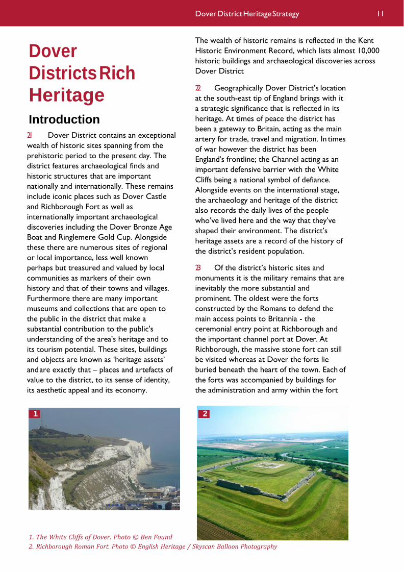
1. The White Cliffs of Dover. Photo © Ben Found
2. Richborough Roman Fort. Photo © English Heritage / Skyscan Balloon Photography
1
11 Dover District Heritage Strategy
2

and civilians outside. At Richborough these
included a triumphal arch, streets and houses,
temples and an amphitheatre. At Dover well
appointed civic and private structures are
known, including the exceptionally well
preserved Roman ‘Painted House’.
2.4 The Roman era ended during the fifth
century AD but the need to defend east Kent
remained. The most famous illustration of
this is at Dover Castle. Although defences
were erected here during the Saxon period
and after the Battle of Hastings, the castle
that can be seen today took shape during the
twelfth century. A great tower or keep, bailey,
curtain wall and towers were built and by AD
1180 it was one of the most powerful castles
attack from the west and north. Dover Castle
was also further strengthened and towards
the end of the same century Fort Burgoyne
was built to protect the town from attack
from the east.
in Western Europe. Changes in both the
military potential of France and Spain, schism
with Catholic powers as well as coastal
change in the Sandwich area led Henry VIII to
build three new castles, linked by lines of
fortifications and now designed both to
deliver and withstand artillery fire, along the
coast at Sandown, Deal and Walmer.
2.5 During the eighteenth and nineteenth
centuries, the increasing ability of nations to
organise fleets and armies of hundreds of
thousands of men, as well as improved
artillery weapons, led to ever more powerful
defences being built at Dover. During the
early nineteenth century the Western Heights
were turned into a massive and complex
fortification with forts, batteries, ramparts
and ditches designed to protect Dover from
2.6 The final stage in the development of
Dover’s defences was during the twentieth
century. Ever more industrialised warfare
required more supplies and logistics and an
entirely new military port was built at
Richborough during the First World War.
During the Second World War the
development of new methods of warfare
such as air attack, bombing, radar and cross
Channel batteries all required new sites to be
constructed in the district. Today, the
district’s coastline is peppered with the
remains of Second World War sites including
‘Winnie’ and ‘Pooh’, the famous cross channel
guns on the Dover cliffs, Swingate Radar
Station, complexes of pillboxes, observation
posts, bunkers and the Secret Wartime
Tunnels excavated deep below Dover Castle
from where the Dunkirk evacuation was
3. Deal Castle. Photo © English Heritage
4. Dover Western Heights. Photo © Explore Kent
5. Richborough Port. Photo © Kent History and Library Centre
3
12
4

commanded. East Kent’s defensive role has
now greatly receded but all these sites
survive and many can still be visited to
remind us of the dramatic events that
occurred in the district, in the sea that
surrounded it and the air above. The human
cost of the wars can also be seen through the
war memorials and monuments across the
district.
2.7 During times of peace Dover was an
essential conduit to the continent for ideas,
goods and people. During the prehistoric and
historic periods many new technologies,
customs and practices entered England from
the continent and many will have come via
Dover. In the centuries before the Roman
conquest, for example, ideas had begun to
spread into England from the continent and
by the time of the conquest Kent was the
most Romanised area of the British Isles.
2.8 In the first century AD Britain’s first
lighthouse (or pharos) was built, and still
stands, on the hill that is now Dover Castle.
The pharos at Dover Castle is the tallest
Roman building surviving in the country. A
second lighthouse, now demolished, was built
on the hill to the west of the port and the
lights of both of these could be seen from
France where a third lighthouse was built in
Boulogne. This new technology was
symptomatic of the new ideas that entered
Kent with the Romans. Roman roads were
constructed between Dover and
Richborough, Dover and Canterbury and
Dover and Lympne and villas - large estate
farms – constructed at Wingham, Sholden,
Walmer and Sandwich. Roman products such
as pottery, jewellery, tools and coins replaced
the earlier British equivalents. New religious
ideas also entered Kent, first pagan Roman
beliefs and rituals and later Christianity.
Indeed, the archaeological remains of a fourth
or fifth century church may exist within
Richborough Fort.
2.9 A much later example of how Dover
District could benefit from new ideas was
during the sixteenth century at Sandwich. In
1561 a royal warrant allowing foreign
craftsmen (Strangers) to manufacture cloth in
England encouraged Flemish and Huguenot
Protestant refugees fleeing religious
persecution in France and the Netherlands to
settle in Sandwich and its neighbourhood.
Most were weavers who brought new skills
to the declining English cloth trade. Others
introduced market gardening to the area.
There was a further influx of Flemish
refugees in 1568, and by 1570 Dutch, Flemish,
Huguenot and Walloon settlers made up
almost half of Sandwich’s population. Even
today, many of Sandwich’s historic buildings
6. Pillbox, Dover Western Heights.
7. Roman Pharos and St Mary-in-Castro, Dover. Photo © Ben Found
7
133
Dover District Heritage Strategy
6

have Dutch elements that indicate the origin
of their builders. Indeed Sandwich has been
described as ‘the completest medieval town
in England’ and it is therefore not surprising
that it has the greatest density of Listed
Buildings of any town in the country.
2.10 As Sandwich’s experience shows,
Dover’s proximity to the continent made it
suitable not just for the transfer of ideas but
of people too. Up to the twentieth century,
many of the peoples or groups who moved
to England first arrived in Kent. The original
Roman raids of 55 and 54 BC took place in
east Kent and probably the full invasion of AD
43.Towards the end of the Roman period,
groups of Angles, Saxons and Jutes arrived in
east Kent, first as raiders and later as settlers.
By the end of the fifth century they had
established the Kingdom of Kent – the oldest
of the Anglo-Saxon kingdoms. Together with
Thanet, Dover has the greatest number and
density of early Anglo-Saxon cemeteries of
any region in England. Many of these contain
fine grave goods that have told us much
about the skills, beliefs and resources of their
owners.
2.11 Today, many heritage assets related to
trade between Kent and the continent still
survive. The English Channel contains a
greater density of shipwrecks than any other
coastal strait in the world. Although many of
these vessels were only passing through the
straits at the time they were wrecked, and
may not have intended to put into port in
Kent, they are nonetheless poignant and often
important reminders of why the port of
Dover exists and on what much of its
prosperity has historically depended. The
most remarkable survival from Dover’s
maritime past is, however, now safely on land.
The Dover Bronze Age boat, presented in
Dover Museum, is the world’s oldest sea-
going boat. At the end of its life in c. 1550 BC
it was abandoned in a backwater where it
remained until its excavation in 1992. Part of
the boat still remains buried beneath
Townwall Street.
2.12 The most dangerous area for wrecks
has always been the Goodwin Sands off the
coast of Deal. These treacherous sands
contain several hundred wrecks including five
of Dover’s six legally protected wrecks (the
other being the Langdon Bay wreck that
dates back to the Bronze Age).The sands are
still dangerous today and The Downs, the
sheltered area between the sands and the
shore, remains a valued anchorage for ships
passing through the Dover Straits. The other
main survivals of Dover’s maritime past are
the dock and port installations. Those of the
prehistoric, Roman and medieval periods still
survive archaeologically at Dover and
Sandwich, and probably elsewhere in the
district. In Dover, Wellington and Granville
Docks, Admiralty and the Prince of Wales
Piers and the Eastern Arm and Outer
Breakwater date mostly from the eighteenth
and nineteenth centuries. They are still in
use
8. Dutch building elements, St Peter's Church, Sandwich.
9. The Dover Bronze Age Boat under excavation. Photo © Canterbury Archaeological Trust
8 9
14
by a range of commercial and leisure users
and are central to Dover’s maritime
character. At Deal the maritime installations
were always much less substantial. There was
no harbour as such although there were a
range of ship and boat building yards, navy
slipways and storehouses. These only survive
archaeologically although the Time Ball Tower
and many of the houses and properties
associated with the maritime trade do
survive and continue to contribute to the
town’s historic coastal character.
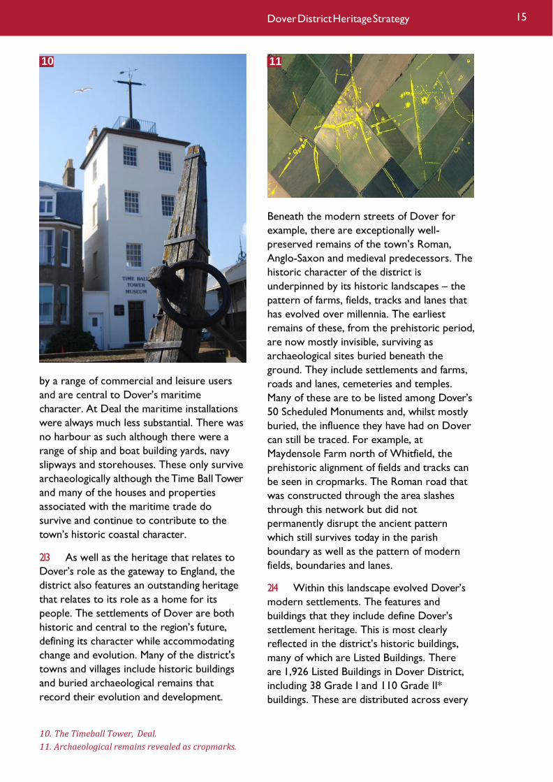
2.13 As well as the heritage that relates to
Dover’s role as the gateway to England, the
district also features an outstanding heritage
that relates to its role as a home for its
people. The settlements of Dover are both
historic and central to the region’s future,
defining its character while accommodating
change and evolution. Many of the district's
towns and villages include historic buildings
and buried archaeological remains that
record their evolution and development.
Beneath the modern streets of Dover for
example, there are exceptionally well-
preserved remains of the town’s Roman,
Anglo-Saxon and medieval predecessors. The
historic character of the district is
underpinned by its historic landscapes – the
pattern of farms, fields, tracks and lanes that
has evolved over millennia. The earliest
remains of these, from the prehistoric period,
are now mostly invisible, surviving as
archaeological sites buried beneath the
ground. They include settlements and farms,
roads and lanes, cemeteries and temples.
Many of these are to be listed among Dover’s
50 Scheduled Monuments and, whilst mostly
buried, the influence they have had on Dover
can still be traced. For example, at
Maydensole Farm north of Whitfield, the
prehistoric alignment of fields and tracks can
be seen in cropmarks. The Roman road that
was constructed through the area slashes
through this network but did not
permanently disrupt the ancient pattern
which still survives today in the parish
boundary as well as the pattern of modern
fields, boundaries and lanes.
2.14 Within this landscape evolved Dover’s
modern settlements. The features and
buildings that they include define Dover’s
settlement heritage. This is most clearly
reflected in the district’s historic buildings,
many of which are Listed Buildings. There
are 1,926 Listed Buildings in Dover District,
including 38 Grade I and 110 Grade II*
buildings. These are distributed across every
10. The Timeball Tower, Deal.
11. Archaeological remains revealed as cropmarks.
11
15 Dover District Heritage Strategy
10

town and village in the district and are also
scattered across its fields and along its
coastline. They are buildings of special
architectural or historic interest and tell the
story of people’s homes, places of work and
worship for more than a thousand years.
Some are of national or even international
renown such as Waldershare Park, Dover
Castle keep, South Foreland lighthouse and
Barfreston Church. Other Listed Buildings are
of more local relevance telling the story of
how ordinary people lived, such as the
Victorian terraces along London Road, Dover
or the eighteenth and nineteenth century
houses along Middle Street, Deal. Some
illustrate Dover’s industrial heritage such as
the remains of Dover’s coal-mining industry
or the mills along the Dour. For all Dover’s
settlements, historic buildings, whether Listed
or not, have helped to shape their evolution
and today are valued landmarks for local
communities. They provide character,
interest and a sense of age within
settlements, often defining the heart of an old
settlement and linking new development with
old.
12. Palaeolithic ice sheets and migratory patterns.
Dover District Heritage Timeline
Palaeolithic (700,000 to 10,000 BC)
2.15 The Palaeolithic marks the first
inhabitation of Britain by humans, though the
ancestors of modern humans only arrived c.
30,000 years ago. Human activity during this
period is largely evidenced from stone tools,
which were primarily produced from flint.
The environment varied considerably during
this period, from frozen tundra to warmer
than present. The degree of human activity
likely varied in relation to the environmental
conditions. Sea levels rose and fell in relation
to the advance and retreat of the ice sheets,
and for the majority of this period Britain
was connected to the continent, allowing the
ingress and egress of the small, migrant
human population. Kent in general has a great
wealth of Palaeolithic material, including the
oldest human skull found in Britain – the
Swanscombe Skull.
16
12

2.16 Within Dover District there is
evidence of activity on the North Downs
around Dover in the Lower and Middle
Palaeolithis, though the amount of
activity is not as great as elsewhere in
Kent. The Upper Palaeolithic, however,
sees a dearth of activity in the district,
with activity focusing towards the west
of the county.
Mesolithic (10,000 to 4000 BC)
2.17 The Mesolithic period saw the end of
the last glacial period and the gradual
increase in the human population. At the
beginning of the Mesolithic Britain was
connected to the continent, only becoming an
island c.8,000 years ago. The small human
population led a hunter-gatherer lifestyle,
with temporary hunting camps following the
migration routes of large animals. This period
saw the development of stone tool
technology, developing from utilitarian hand
axes to more specialized blades, choppers,
arrows, and axes.
2.18 The Early Mesolithic sees a
continuation of the dearth of sites in Dover
District, though there is a marked increase in
activity in the Later Mesolithic (though again
not as great as in the west of the county).
Evidence is primarily in the form of flint tools,
with a substantial assemblage at Finglesham,
where the concentration of axes suggests
substantial forest clearances in this area.
Neolithic (4000 to 2500 BC)
2.19 The Neolithic period saw arguably
some of the most important advances in
human history, with the cultivation of cereal
crops on a large scale and the adoption of
animal husbandry. The benefits of
agriculture and a sedentary lifestyle led to
changes in technology, society, and
economics, notably the vast increase in the
use of pottery. This transition is seen
earlier on the continent, and the proximity
of Kent to the continent sees the adoption
of these changes earlier than other parts of
the country.
2.20 The invention of agriculture and the
subsequent adoption of a more sedentary
lifestyle led to a greater investment in the
landscape. Forests were cleared for
agriculture and settlements became more
permanent. As populations grew social
relationships became more complex,
especially the relationship between the living
and the dead. Monumental ‘ritual’ architecture
developed, with long barrows and
causewayed enclosures in the earlier
Neolithic, which gave way to henges, stone
circles, and cursuses in the later Neolithic.
2.21 There are no known long barrows in
Dover District, as are seen elsewhere in the
county, however there is a possible
causewayed enclosure at Tilmanstone. From
pottery evidence, settlement activity seems
to be focused around Deal. Settlements
themselves are rare in Kent, with long houses
being particularly elusive.
Bronze Age (2500 to 700 BC)
2.22 The Bronze Age saw an increase in the
size and social complexity of communities,
and, notably, the first use of metalworking in
13. A Palaeolithic handaxe found near Shepherdswell. Photo © Portable Antiquities Scheme
13
17 Dover District Heritage Strategy

Britain. The expanding population and the
advent of metal tools allowed forests to be
cleared on a larger scale to provide land for
agriculture. Cleared land was often divided up
into field systems, reflecting the increasing
social complexity that was developing.
Increasing food production, an increasing
population, and new technologies led to the
emergence of specializations in the
population, including the emergence of a
social élite. Monumental ‘ritual’ architecture
shifts from the communal to the individual,
with barrows and elaborate grave
assemblages reflecting the high social status
of a select few. An increasing population
meant that settlements become more
common, often consisting of groups of
roundhouses, sometimes within a ditched
enclosure. A few high status sites also
developed, which were the hub of the new
industries that were emerging, namely
weaving, metalworking, and salt extraction.
Regional cultures began to develop, most
prominently shown in the variations in
pottery types, though there is evidence that
extensive trade routes existed, including links
with the continent. There is evidence of a
collapse of trade routes at the end of the
Bronze Age and a degree of social change.
2.23 The Isle of Thanet and the Wantsum
Channel are the focus of settlement activity
in east Kent during this period, and there is a
high status site at Mill Hill, Deal (which was
situated at the southern extent of a stretch
of the Wantsum). There is evidence for
activity across the rest of the district,
including a probable settlement at Dover.
Two boats were discovered at Langdon Bay
and Dover, highlighting the importance of
coastal transport and cross Channel contact.
Iron Age (700 BC to AD 43)
2.24 The Iron Age sees the development of
iron-working technology. Social relations
become more complex and the development
of new technologies and trade routes led to
an increase in the range of goods people had
access to. Settlement is extensive in the Early
Iron Age, especially in the east of Kent.
There is a notable lack of settlement
evidence in the Middle Iron Age, for
unknown reasons, though a number of
hillforts develop, probably primarily as social
and ritual centres rather than defences sites.
The Late Iron Age sees an increase in
settlement activity again. There is less of an
emphasis on defended settlements during the
Late Iron Age, and hillforts are replaced by
oppida. These extensive sites were the new
residences of the social élite, and had a range
of social and economic roles. Coinage
develops during the Late Iron Age, and
larger-scale industries begin to develop,
showing both increased social organization
and increased trading opportunities. Social
changes in the Late Iron Age extend to burial
practices. Prior to the Late Iron Age human
remains are rare, but from the Late Iron Age
Inhumations and cremations become more
prominent.
2.25 The Late Iron Age sees the expansion
of the Roman Empire across continental
Europe, which exposed southern Britain to
new trade routes and a range of new
technologies, ideas, and goods. Caesar’s
expeditions in Kent in 55 and 54 BC had
profound consequences for the ruling élite.
Many parts of southern Britain effectively
became client states of the Roman Empire.
The main consequences of this for the
14. A Late Bronze Age metalwork hoard found near Hoaden. Photo © Portable Antiquities Scheme
14
18

populace were increased political stability and
the increase in trade routes leading to a
greater variety of consumer goods.
2.26 Early Iron Age settlement is
concentrated in the east of the county, with a
large number within Dover District. The
ramparts of Dover Castle have been
conjectured to have evolved from an Iron Age
hillfort. There is a marked decrease in known
sites of the Middle Iron Age in the district – a
trend which is comparable to the rest of the
county. Major activity of Middle Iron Age date
is limited to a settlement site at Worth and
occupation activity at Dover. Late Iron Age
settlement is more widely distributed across
the district, with notable sites including a
religious site at Worth and a cemetery at Mill
Hill, Deal. The North Downs trackway may
date to this period.
Roman (AD 43 to 410)
2.27 By the first century AD much of
southern Britain had effectively become de
facto client states of the Roman Empire and
the formal inclusion of Kent within the
Roman Empire in AD 43 with the arrival of
Claudius does not appear to have had any
significant impact. Rural settlement continued
to be dominated by small groups of
roundhouses within a ditched enclosure,
though the social élite increasingly adopted
the Mediterranean architectural styles,
notably building country villas. Towns develop,
with a greater focus on the use of stone than
before, and metalled roads cross the
landscape on an unprecedented scale,
connecting towns, military stations, and
important industrial sites. Large scale industry
is a feature of the Roman period, with the
exploitation of the iron deposits in the Weald,
and extensive salt-workings and pottery
production. Kent was also a prolific producer
of grain, which was exported to other parts
of the Empire. Inclusion within the Empire,
and the extensive road network allowed for
extensive trade routes and the range of
consumer goods increased.
2.28 Although the Empire brought internal
peace, the military was a significant presence
within east Kent throughout the Roman
period. The probable Claudian landing site at
Richborough in AD 43 became the main port
of entry into the country and the start of
Watling Street which ran to London.
Alongside the fort there was a small civilian
settlement, with temples, mansio (official
guesthouse), and an amphitheatre. A large
15. The 'Mill Hill Warrior' - an Iron Age grave from Deal containing a sword (1), shield (2), crown (3), decorated brooch (4), decorated bronze suspension ring (5) and a bronze strap-end decorated with coral (6).
15
19 Dover District Heritage Strategy

quadrifrons (triumphal arch) was built at
Richborough, straddling the road, to signify
the conquest of the whole of Britain. From
the early to mid second century AD Dover
replaced Richborough as the main port of
entry, and became one of the stations of the
Classis Britannica (the Roman fleet in the
English Channel). Again, a fort was
accompanied by a mansio, the magnificent
Roman Painted House, and civilian settlement.
The importance of Dover as a port of entry
is highlighted by the construction of two
lighthouses on the Eastern and Western
Heights sometime in the first century AD.
The lighthouse on the Eastern Heights
remains standing. From the third century
onwards a series of new forts were built
along the east and south coast of Britain. In
the early fifth century these were referred to
as the Forts of the Saxon Shore, though there
is no evidence that they were initially
conceived as an integrated line of defences. A
fort was built at Dover c. AD 270 and at
Richborough c. AD 277.
2.29 The Roman road network within the
District is not fully understood, though
Dover, Richborough, and Canterbury were
certainly linked. There is a notable lack of
known villas to the east of Canterbury when
compared to the west of the county, and
there are only four proven villas in Dover
District, although an additional fifth possible
villa site has recently been identified on aerial
photographs near Ash. Findspots suggests
that there was probably fairly dense rural
occupation around Deal and the southern
end of the Wantsum, though the precise
nature of any settlements is unknown. There
is also some evidence for agricultural
specialisation in the district in the Roman
period, including the growing of spelted
barley, presumably for brewing. In this area
also is the temple at Worth, which continued
in use into the Roman period. Christianity
spread in the third century AD, and a font at
Richborough may be one of the earliest signs
of Christianity in the district.
16. The Roman Pharos at Dover Castle. Photo © Andrew Mayfield
16
20

Anglo-Saxon (AD 410 to 1066)
2.30 Following the withdrawal of the Roman
army from Britain c. AD 410, the eastern
areas of Britain began to be settled by
peoples from northern Germany and
southern Scandinavia, namely the Angles,
Saxons, and Jutes. Whether they were
migrants or invaders is uncertain, though
from the middle of the fifth century onwards
their material culture begins to become
common. The decline of the Roman Empire
led to a decrease in continental trade, though
finds suggest that Kent appears to have
maintained good trade links with the
continent. St Augustine reintroduced
Christianity in AD 597, with early churches
built soon after. Kent continued to be a
centre of Christianity throughout the period,
with bishops at both Canterbury and
Rochester. The Kingdom of Kent became
powerful in the seventh century, but its
influence waned after this. The Viking
incursions of the ninth and tenth centuries
largely avoided Kent, perhaps reflecting its
relatively low political influence towards the
end of the period.
2.31 Rural Anglo-Saxon settlement evidence
in Dover District is relatively sparse, and little
is known of the towns in the early Saxon
period. Dover appears to have remained a
major settlement and exceptionally well
preserved Saxon period remains have been
found in the centre of the town. It was
probably a major trading centre, with links to
the continent. It was also the centre of a vast
estate, and there was likely a defended site on
the Eastern Heights during this period.
Sandwich developed as a wic (trading site)
from c. AD 650, though the exact nature of
Saxon Sandwich is uncertain. Richborough
probably became a small religious settlement
and port, while Wingham and Eastry
developed as the centres of estates, the latter
being a royal estate. In the late Saxon period
Dover and Sandwich were major settlement
centres, both being sites of mints. Evidence
for a rural Saxon settlement has been
recorded at Whitfield.
2.32 Burial evidence of this date is extensive
in eastern Kent, with particularly large
inhumation cemeteries at Buckland and
Finglesham. Kent had some of the earliest
churches and monasteries in the country,
with St Martin’s Priory in Dover dating to the
early seventh century, and a possible
monastery founded at Eastry later in that
century. A number of churches in the district
also have Saxon origins. St Mary-in-Castro, in
Dover, is the most complete Saxon church
within the District, dating to c. AD 1000.
Medieval (AD 1066 to 1540)
2.33 Most of the landscape of Kent was
formed in the medieval period, as small Saxon
settlements grew into larger villages and
towns. Following the Norman Conquest
which began in AD 1066, there was an
increased focus on architecture created by
the military and for religion. Thus many small
wooden Saxon churches were rebuilt in
stone, some on a monumental scale, and
there was a great increase in the size and
number of stone-built castles. The church
became very powerful during this period, and
held land and properties across the country.
Canterbury was an especially important
religious centre, both as the seat of the
country’s highest religious figure, and as an
important pilgrimage centre. Trade links with
the continent grew, and the ports of Kent
became important centres, with four of the
17. Anglo-Saxon brooches from Buckland cemetery, Dover. Photo © Canterbury Archaeological Trust
21 Dover District Heritage Strategy
17

five main Cinque Ports in Kent. Notable
industries that grew in Kent during this time
included brewing, tanning, tile-making, wool
production, weaving, and iron-working.
2.34 Dover Castle dates to this period.
William I’s army first burnt the Saxon
fortifications on the Eastern Heights and then
built new fortifications. The massive stone
keep and curtain walls were built from the
mid twelfth century onwards. The castle
subsequently became a royal castle, indicating
the status and strategic importance of Dover.
The only other early castle in the district was
at Coldred dating from the late eleventh to
mid twelfth centuries. Slightly later, towards
the close of the thirteenth century, a small
castle was built at Sandwich. Dover castle was
besieged in 1216 with a failed invasion of the
French, while Sandwich was raided by the
French in 1457. Only five towns in Kent had
known walls during this period, two of which
are in Dover District. At Sandwich, earthen
ramparts were constructed in the mid to late
thirteenth century, with further modifications
18
18. The Fishergate, Sandwich.
and the addition of small sections of stone
wall over the next 200 years. The
ramparts and two gates survive. Dover
had walls of some sort by 1231, which
were added to over the next 200 years,
though they probably never completely
enclosed the town. No standing remains
survive.
2.35 Many of the parish churches have fabric
dating to the Norman period, though most
were heavily altered to cope with an
expanding population over the next 500
years. The religious centres of Langdon
Abbey, St Radegund’s Abbey, Dover Priory,
Sandwich Friary, and Wingham College
expanded over this period. This period also
saw the rise of centres of healing, initially
centres healing the soul, and later hospitals
healing the body. A number of institutions
were founded in Dover and Sandwich. Dover,
located at the eastern end of the Pilgrim’s
Way, was an important pilgrimage centre,
both as home to the shrine of Thomas de la
Hale and as a gateway between Canterbury
and the continent. The Reformation of the
mid 16th century marked the decline of the
influence and control of the church on the
wider landscape. Langdon Abbey was one of
the first, if not the first, religious house to be
dissolved, in 1535. St Radegund’s Abbey
followed in 1536,Wingham College in 1537,
and Dover Priory and Sandwich Friary in
1538.
2.36 Sandwich and Dover were major
trading centres, being two headports of the
Confederation of the Cinque Ports. Stonar
and Deal were smaller ports in the trading
and defensive network. By the start of the
sixteenth century most of the harbours along
the east Kent coast were silting up. Dover,
which also had an important naval function,
invested in large harbour works to combat
this. For the other ports, the end of this
period was marked by a general shift in trade
to ports away from Kent.
22

Post-Medieval (AD 1540 – modern)
2.37 The post-medieval period sees rapid
and extensive growth of the population in
Kent, and subsequently their impact on the
landscape. The population of Kent has grown
from somewhere around 100,000 in 1500 to
almost 1.7 million in 2010. In addition to a
vast increase in settlement size, there has
been a great increase in industry, while other
institutions, such as the church, have declined
in importance. New transport links have
developed as well, most notably increases in
the road network and the construction of the
rail network, but also increased links with the
continent through the growth of ferry
transport and the Channel Tunnel Rail Link.
Increasingly great importance was placed on
defence of the county, with successive lines of
defence being constructed along the east
coast.
2.38 The population of Dover District has
not seen the same scale of growth as
elsewhere in the county, with the population
of the whole District currently only around
100,000. The population of the major towns
changed little from the beginning of the
period up to the nineteenth century. During
this century Dover and Deal saw rapid
growth from around 10,000 each to around
40,000 and 20,000 respectively. Sandwich,
however, has seen relatively little growth, and
the scale of growth of the district is
comparatively low compared to other parts
of the county.
2.39 One of the major industries to affect
the district was coal mining, which developed
over the course of the early twentieth
century, with peak output in 1935. Collieries
were founded at Snowdown,
Tilmanstone, and Betteshanger, with
accompanying small planned settlements at
Aylesham, Elvington, and Mill Hill. A network
of light railways was constructed, and an
aerial ropeway was built to connect
Tilmanstone with Dover harbour.
2.40 Other major features of the district are
the various defensive sites. Castles were built
at Sandown, Deal, and Walmer between
1539-40 as part of the Henrician coastal
defence system. As part of the Napoleonic
defences these were supplemented by two
shore batteries at Sandwich. Additions were
made to Dover Castle and, most notably, the
Western Heights were developed as a
fortress. Further additions were made to the
Eastern and Western Heights over the
nineteenth century. The First World War
saw coastal batteries at Dover and the
development of port facilities and a military
camp at Richborough. The Second World
War saw further coastal batteries, airfields,
and pillboxes as part of defence lines.
2.41 The first turnpike act in the district
came into force in 1753, though the majority
of turnpike acts were issued around the turn
of the nineteenth century. The first railway in
the district was built in 1844, connecting
Dover to Folkestone. A number of other
lines were constructed over the next 40
years, followed by the light railways
connecting the collieries. Dover was the only
town in the district to have a tram network,
which was in operation from 1897 – 1936.
Deal and Sandwich continued to lose
importance as ports. Dover, however,
continues to be of national importance as a
port, both in terms of commercial and public
shipping.
19. Fishing boats on Deal beach. Photo © Explore Kent
23 Dover District Heritage Strategy
19

Significance of Dover’s Heritage
2.42 As a group the heritage assets in Dover
District are considered to be of outstanding
significance. The district’s archaeology,
historic buildings and historic landscapes are
of national and international importance.
Discoveries such as the Dover Bronze Age
boat and the Ringlemere Cup have helped to
improve our understanding of the movement
of peoples, ideas and goods in the prehistoric
period. That these finds were made by
chance shows clearly the potential for
significant further archaeological finds to be
discovered within the district. Major heritage
sites such as Richborough Roman Fort and
Dover Castle have been known about for
much longer, but nevertheless are likely to
contain important evidence that could
further improve our understanding of key
events and periods in British history.
Arguably the most significant monuments in
the district relate to defence and countering
the threat of invasion. The District’s Channel
location has
meant that it has always been on the front-
line in conflicts with continental Europe. As
such the district contains an unparalleled
collection of defensive heritage assets
spanning nearly 2,000 years from the Roman
invasion to the Cold War.
2.43 Throughout this strategy reference is
made to the suite of ‘Heritage Values’ set out
in Historic England’s Conservation Principles
(2008). These values seek to explain why
people value historic assets and places; they
set out a range of complementary and
overlapping values which help to articulate
how the significance of a place, theme or
asset is understood. The values are divided
into four strands – evidential value, historical
value, aesthetic value and communal value.
2.44 Evidential value – the evidential value
of the district’s heritage assets is immense.
The archaeological record of the district
holds important evidence for interaction and
relations between Britain and Europe.
Evidence for the movement of people, ideas
and goods across the Channel can be charted
in the heritage of the district. The heritage of
the district also has the potential to provide
important new information on the
development of settlement in the district and
shed light on the past lives of the people who
have lived in and shaped the modern
landscape.
2.45 Archaeological research projects,
development-led archaeological investigations,
environmental archaeology and the use of
scientific analysis all hold a great potential to
further realise and discover important and
new evidence.
2.46 Illustrative value – The district’s
heritage assets illustrate numerous events
that played out on the national and
international stage. These include, for
example, important Roman sites containing
both above ground and below ground
remains that show the impact of the arrival of
20. The Fairburn Crane, Dover Harbour
24
20

the Roman army in AD 43, life under Roman
rule and the decline and fall of Roman Britain.
It is not just the district’s ancient remains
that are of importance. More recent conflicts
have left their mark on the district’s
landscape. The anti-invasion remains of the
Second World War period illustrate, for
example, the very real fear of German
invasion that impacted on the everyday lives
of people across the district. Numerous
other conflicts and events have equally left
their mark and provide an accessible and
understandable illustration of national and
international history at a local level.
2.47 The heritage assets of the district also
provide a link to important past peoples and
are associated with numerous rulers, kings,
notable families and individuals. From
Churchill’s visits to ‘hellfire corner’ in the
Second World War to Caesar’s landing near
Deal – the district’s heritage assets allow
locals and visitors alike to connect with key
people from the past. Sites such as Walmer
Castle, with its collection of Wellington
memorabilia and recreation of the Duke’s
21. Boats moored at Sandwich Quay.
apartments provide an intimate insight into
the life and personality of a well-known and
significant historical figure.
2.48 Aesthetic value – the aesthetic values
of Dover District’s heritage assets are wide
and varied; from the wide rolling down-land
landscapes, shaped by generations and now
celebrated as an Area of Outstanding Natural
Beauty, to the attractive ancient church which
forms the centrepiece of a historic village.
Some places such as Dover Castle are iconic
and recognised and celebrated widely for
their aesthetic qualities. Other places are
more intimate and valued by the local people
who experience them daily. Military remains,
such as the sheer walls and ditches of the
Drop Redoubt, can inspire feelings of awe and
fear that resonate well with the original
purpose of the fortifications and help visitors
to appreciate their defensive might. Other
sites, like the historic parkland at Waldershare
or Goodnestone, for example, are
deliberately designed to be aesthetically
pleasing and continue to be valued because of
this. The district’s many historic villages and
25 Dover District Heritage Strategy
21

farmsteads are now valued aesthetically, but
were not necessarily designed to be so – they
have become imbued with an aesthetic quality
arising from a patina of age. The district's
industrial heritage includes many buildings
that while utilitarian in their design stand as
powerful imposing structures, with attention
to detail that conveys both the power of the
industries and the pride of those that worked
in them.
2.49 Communal value – the communal
values of the district’s heritage assets are
equally wide-ranging and varied. The
historic environment of the district is key
to providing a sense of place. Many people
draw emotional and intellectual stimulation
from the district’s heritage assets. Dover
Castle, for example, which sits above and
dominates the town of Dover is symbolically
valuable to many and is an important part of
the district and its identity. The district’s
extensive Second World War remains are
not just important for their illustrative value
– they are also a visual and commemorative
link to the losses that the people of Dover
suffered during the war and of the bravery of
those who manned the defences.
22. Exploring the Western Heights. Photo © Explore Kent
22
26

3 Heritage Assets

Heritage Assets
Definition of a heritage asset
3.1 A building, monument, site, place or
landscape identified as having a degree of
significance meriting consideration in planning
decisions, because of its heritage interest. It
includes designated heritage assets and assets
identified by the Local Planning Authority
(including Local Listing). NPPF Annexe 2.
3.2 In planning terms the concept of
‘heritage assets’ was a key feature of Planning
Policy Statement 5 which unified previous
planning policy guidance. The principle of
considering the historic environment in a
holistic manner is continued in the
Government’s NPPF and the concept of
heritage assets remains a key building block
of the framework. Elements of the historic
environment that are worthy of
consideration in planning matters were
termed ‘heritage assets’.
3.3 A heritage asset will hold meaning to
individuals and groups of individuals beyond
their purely functional utility. Heritage assets
have been shaped by people responding to
their local environment, but will also help to
shape that environment in the future. They
have a significant role to play in creating a
sense of place and acting as a catalyst for
regeneration. The district’s heritage assets
add distinctiveness, meaning and identity to
the place and are an exceptionally valuable
local resource.
3.4 It is therefore important that the
significance of the district’s heritage assets is
taken into account as part of any future
development management, regeneration or
maintenance decisions and opportunities are
sought, wherever possible to enhance the
district’s heritage assets.
Types of assets and designations 3.5 The term heritage assets encompasses
all sorts of features, including buildings, parks
and gardens, standing and buried remains,
areas, sites and landscapes. Some heritage
assets possess a level of significance that
justifies designation. The following statutory
designations covering heritage assets exist
within Dover:
• Scheduled Monuments
• Listed Buildings
• Conservation Areas
• Registered Parks and Gardens
• Protected Wreck Sites off the coast of
Kent.
1. Goodnestone Park, a Grade II* Listed Building set in extensive parkland. The house's gardens and parkland are included on the English Heritage Register of Parks and Gardens of Special Historic Interest. Photo © Ben Found
1
28 Dover District Heritage Strategy

3.6 Other heritage assets may be indirectly
provided with statutory protection. For
example, Areas of Outstanding Natural
Beauty (AONBs) are designated to
protect the natural beauty of a place and
heritage assets may form an important
part of what makes an AONB special.
Scheduled Monuments
3.7 Scheduled Monuments are those
archaeological sites which are considered to
be nationally significant and as such have been
given legal protection by being placed on a list
by the Secretary of State for Culture,
Olympics, Media and Sport. The Ancient
Monuments and Archaeological Areas Act of
1979 provides the legislative framework for
this list. Scheduling is legal protection
afforded specifically to archaeological sites.
Listed Buildings
3.8 Significant historic buildings or
structures are provided with statutory
protection by being placed upon the
Statutory List of Buildings of Special
Architectural or Historic Interest. Buildings
which have been placed upon this statutory
list are known as Listed Buildings and are
graded using the following criteria:
• Grade I buildings are of exceptional
interest, sometimes considered to be
internationally important; only 2.5% of Listed
Buildings are Grade I
• Grade II* buildings are particularly
important buildings of more than special
interest; 5.5% of Listed Buildings are Grade II*
• Grade II buildings are nationally
important and of special interest; 92% of all
Listed Buildings are in this class and it is the
most likely grade of listing for a homeowner.
3.9 Listed Building Consent is required
from the Local Planning Authority for any
alteration, extension or demolition works
which may affect the special historic or
architectural character of the building. The
Planning (Listed Buildings and Conservation
Areas) Act 1990 provides the legislative
framework for the Listed Building process.
2. The ruins of St Radegund's Abbey are a Grade II* Listed Building and Scheduled Monument. Photo © Adam Hincks
2
29
Conservation Areas
3.10 Conservation Areas are designated
where a place is of special historic or
architectural interest, and where it is
desirable to preserve or enhance the
character and appearance. Conservation
Areas are mostly designated by the Local
Planning Authority. Owners or users of a
property in a Conservation Area require
permission to carry out certain types of
alterations to that property, to demolish or
substantially demolish a building and to notify
their intention to cut down or prune trees in
the area. Additional restrictions on small scale
development and alterations within a
Conservation Area can be secured through
the application of Article 4 and in particular
Article 4(1) Directions which can be used to
remove permitted development rights.
Registered Parks and Gardens
3.11 Since 1983 Historic England has
maintained a Register of Historic Parks and
Gardens of special historic interest in
England.This Register is specifically
concerned with gardens, grounds and planned
open-spaces and the emphasis is on the
significance of the place as a designed
landscape, rather than its botanical
importance. Registration is a ‘material
consideration’ in the planning process,
meaning that planning authorities must
consider the impact of any proposed
development on the landscape's special
character. As with Listed Buildings, the
Registered Parks and Gardens are graded as
per the following criteria:
• Grade I sites are of exceptional interest
• Grade II* sites are particularly
important, of more than special
interest
• Grade II sites are of special
interest, warranting every
effort to preserve them.
Protected Wreck Sites
3.12 The Protection of Wrecks Act (1973)
provides the legislative framework for
designating the remains of vessels (or their
contents) which are of historical, artistic or
archaeological importance. It is a criminal
offence for anyone to tamper with, damage
or remove any part of a protected wreck or
its contents.
None designated heritage assets
3.13 The majority of heritage assets will not
be designated. Some heritage assets may be
of a level of significance which would not
warrant formal designation, whilst other
assets may not currently be designated either
because their significance has only recently
been revealed or has never been formally
considered. Some of the undesignated
heritage assets are of equivalent significance
to those that are.
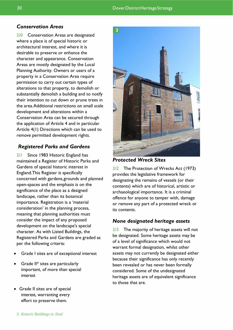
3. Historic Buildings in Deal
30 Dover District Heritage Strategy
3

3.14 Some assets may have a locally-defined
designation; these do not have any statutory
framework underpinning them but represent
recognised heritage assets of local
significance or value. As there is no adopted
local list of buildings for Dover, the only
locally-defined designations are the Historic
Parks and Gardens.
3.15 Non-designated heritage assets are all
those recognised elements of the historic
environment not covered by one of the
above designations. These include standing
buildings, below-ground archaeology and
archaeological findspots, earthworks,
maritime features (principally shipwrecks) and
aircraft crash sites (though most of the latter
are covered by the Protection of Military
Remains Act 1986).
Table quantifying designated and non-designated heritage assets recorded in the Kent Historic
Environment Record (as of April 2020)
4. Archaeological investigations ahead of housing development in Walmer.
5. Dover Eastern Docks and the White Cliffs. Photo © Ben Found
4
31
Designated Heritage Assets
Scheduled Monuments 50
Listed Buildings 1926
Conservation Areas 57
Registered Parks and Gardens 6
Protected Wreck Sites 1
Locally designated Heritage Assets
Historic Parks and Gardens 21
Non-designated Heritage Assets
Standing Buildings 772
Belowground Archaeology 9845
Maritime Features (excludes
offshore wrecks
33
Aircraft Crash Sites 0
5

4 Heritage Themes

Dover districts Heritage Themes Introduction to themes
4.1 The archaeology and heritage of Dover
District is exceptionally rich, varied and
extensive. It was therefore realised at an early
stage that in order to properly define and
characterise these assets it would be
necessary to consider them through broad
groups and themes. A list of the groups and
themes, along with broad summaries is
included below. The theme papers
themselves are included as Appendix 1 of this
strategy.
4.2 In identifying a list of themes for this
strategy, consideration was given to those
aspects that particularly contributed to local
distinctiveness or have played an important
role in shaping the character of the district.
A more general description of the richness of
A the district’s heritage is provided through
the asset-based themes, considering the
resource in terms of asset groupings.
4.3 The following themes and theme
groups were considered as part of the
present study (due to the complexity of
some themes these have been treated by
individual sub-theme):
1 Coastal Processes and landscapes
2 Coastal Ports
2.1 Sandwich & Stonar
2.2 Deal Port and The Downs
2.3 Dover Harbour
3. Invasion and defence
3.1 Roman Gateway
3.2 Arrival of the Saxons
3.3 Medieval defences
3.4 The Castles of the Downs
3.5 Post-medieval defences
3.6 The Great War and Supply of the Western Front 3.7 Second World War defences
3.8 Barracks
3.9 Cold War
4. Communications
4.1 Historic road, routes and lanes
4.2 Railways
4.3 Cross Channel travel
4.4 Flight
5. Maritime
5.1 Coastal features and leisure
5.2 Wrecks
6. Church
7. Country Houses and estates
7.1 Great houses and estates
7.2 Courts and Manors
8. Settlement
9. Agriculture and Farmsteads
10. Industry
10.1 The East Kent Coalfield
10.2 Dour Mills and Industries
10.3 Quarrying
11. Archaeology
12. Built Heritage
13. Conservation Areas
1. South Breakwater Lighthouse, Dover Harbour.
33 Dover District Heritage Strategy
1

4.4 It is recognised that there are significant
heritage assets within the district that do not
easily fall in to the above themes and that
arguments could be made for additional
themes which are important to the district
for example prehistoric settlement and land-
use, coastal leisure, civic buildings, cemeteries
and historic parks and gardens, ancient
woodlands, trees, hedgerows and the
character of the historic landscape. It is
envisaged that future studies could add to the
theme list above.
Themes methodology, values and significance 4.5 Themes were investigated using a desk-
based approach, with a number of different
sources of information consulted. Some
limited site visits were made where on the
ground clarification was needed or where
desk-based sources were contradictory or
inconsistent. Outputs comprised thematic
based studies (which are included as an
appendix) as well as GIS layers, which have
been used as a basis for the production of the
illustrations accompanying the theme papers.
4.6 The thematic studies are not intended
to provide a definitive list of all heritage
assets relating to a particular theme; rather,
they are intended to provide an illustration of
significant elements, examples or key
groupings of the district’s heritage assets that
contribute to the significance of the theme.
The nature of such a theme based approach
means that there will be considerable overlap
between themes, groups and sub-themes. As
such some heritage assets feature in multiple
themes; where possible cross-references have
been included to other relevant themes.
4.7 Each theme study comprises an
introduction to the theme, a written
description of the principal heritage assets, a
tabulated list of key heritage assets and a
statement of significance for that theme.
The theme studies also highlight any
significant vulnerabilities or opportunities
connected with either the theme as a whole
or to specific assets within that theme.
Significance
4.8 Measures for assessing the significance
of the themes and groups in their various
aspects have been based on the values
(where relevant) set out in Historic England’s
Conservation Principles. These values are:
evidential, illustrative, aesthetic and
communal. Evidential value derives from the
potential for heritage assets to yield further
evidence of past human activity. The
evidential value of the theme is based on the
potential capacity of the assets to provide
additional information upon investigation.
Historical value derives from the way in
which past people, events and aspects of life
can be connected through a theme to the
present. Historical values may be
represented through the ability of an asset to
illustrate an aspect of history or prehistory
on a wider scale, or
2. Guns at Dover Castle.
3. Archaeological excavations at Ringlemere.
34
2 3

by association with a specific notable family,
person, event or movement. Aesthetic value
derives from the ways in which people draw
sensory or intellectual stimulation from a
place. It is recognised in the present study
that some assets may have an aesthetic value
as a result of deliberate and conscious
designs, whereas the aesthetic value of other
places may be accidental or secondary to
their primary function. Communal value
derives from the meanings of a place for the
people who relate to it, or for whom it
figures in their collective experience or
memory. As part of the communal value
consideration has also been given to the
amenity value of themes or elements therein.
4.9 The overall assessment of significance is
considered in terms of its evidential,
historical, aesthetic and communal values and
is intended to reflect the theme, group or
sub-theme as a whole. Assets may individually
be of greater or lesser significance or may
contribute to the significance of multiple
themes or have an additional group value.
The degrees of significance adopted in the
Dover District Heritage Strategy are:
• Outstanding Significance: themes
which are of key national or international
significance. These are those themes that
contain significant heritage assets, which are
among the best (or the only surviving
example) of an important type of monument,
or are outstanding representatives of
important social or cultural phenomena, or
are of very major regional or local
significance.
• Considerable Significance: themes
which contain heritage assets that are good
and representative examples of an important
class of monument (or the only example
locally), or have a particular significance
through association (although surviving
examples may be relatively common on a
national scale)
4. Entrance to the Drop Redoubt.
4
35 Dover District Heritage Strategy

• Moderate Significance: themes which
contribute to the character and
distinctiveness of the district, or which
provide an historical or cultural context for
other themes that may be of individually
greater significance.
• Low Significance: themes which are of
individually low value in general terms, or
have little or no significance in promoting
understanding or appreciation of the district,
without being actually intrusive.
• Uncertain Significance: themes or
elements therein which have the potential to
be significant (e.g. buried archaeological
remains) but where it is not possible to be
certain on the evidence currently available.
• Intrusive: themes or elements therein
which detract visually from or which obscure
understanding of significant elements or
values of the district. Recommendations may
be made on their removal or other methods
of mitigation.
4.10 The table below sets out the
significance of each of the themes assessed
for the Heritage Strategy
Theme Significance
1 Coastal Process and
landscapes
Outstanding
2.1 Sandwich & Stonar Outstanding
2.2 Deal Port and The
Downs
Outstanding
2.3 Dover Harbour Outstanding
3.1 Roman Gateway Outstanding
3.2 Arrival of the Saxons Considerable
3.3 Medieval defences Outstanding
36
Theme Significance
3.4 The Castles of the
Downs
Outstanding
3.5 Post-medieval defences Outstanding
3.6 The Great War and
Supply of the Western Front
Considerable
3.7 Second World War
defences
Outstanding
3.8 Barracks Moderate to
Considerable
3.9 Cold War Moderate
4.1 Historic roads, routes
and lanes
Moderate to
Considerable
4.2 Railways Moderate
4.3 Cross Channel travel Considerable
4.4 Flight Moderate
5.1 Coastal features and
leisure
Considerable
to
Outstanding
5.2 Wrecks Outstanding
6 Church Outstanding
7.1 Great houses and
estates
Considerable
7.2 Courts and Manors Moderate to
Considerable
8 Settlement Outstanding
9 Agriculture and
Farmsteads
Moderate to
Outstanding
10.1 Kent Coalfields Considerable
10.2 Dour Mills and
Industries
Moderate
10.3 Quarrying Low to
Moderate
11 Archaeology Outstanding
12 Built Heritage Outstanding
13 Conservation Areas Outstanding

Limitations and assumptions
4.11 The data used to comprise the theme
studies was largely comprised of secondary
information obtained from a variety of
sources, only some of which were directly
examined. Where possible, sources have
been cross-referenced and cross-examined
to ensure accuracy. The general assumption
was made that this data as well as that
derived from other secondary sources is
reasonably accurate, but none the less some
errors may be expected. Given the time
limits posed upon the study, only those
sources that were readily and easily
accessible were examined. It should be noted
that the information held within these
sources will not be complete and does not
preclude the subsequent identification or
discovery of other significant heritage assets
that are, at present, unknown.
4.12 The theme papers presented in the
Heritage Strategy present a snap-shot in time
of the district’s heritage assets. New
discoveries are continually being made and
new information constantly coming to light.
Theme summaries
Theme 1 Coastal Processes and
Landscapes
4.13 Dover District contains exceptional
coastal landscapes of national and
international renown. The White Cliffs of
Dover are recognised around the world and
form part of a coastal landscape of
outstanding historical significance. In the
north of the district the creation and
reclamation of the Wantsum Sea Channel and
the formation of the Deal and Stonar spits
has shaped the area’s landscape and history.
Dover itself owes its existence to the River
Dour which carved an opening in the
formidable chalk cliffs providing a safe haven
and harbour for vessels passing through and
crossing the English Channel.
Theme 2.1 The Coastal Ports of
Sandwich and Stonar
4.14 Sandwich and Stonar are both
outstandingly important examples of medieval
coastal ports. Both sites contain
archaeological remains of the highest quality,
including well-preserved waterlogged
deposits. Whilst Stonar survives only as
buried archaeological remains, Sandwich is
blessed with many fine medieval buildings
flanking its winding historic streets.
Theme 2.2 Deal Port and The Downs
4.15 Now a quiet sea-side town, Deal was
once among the most important naval ports
in the Country. Vessels at Deal made use of
the major anchorage of The Downs,
protected by three powerful castles built by
Henry VIII. In the seventeenth, eighteenth and
nineteenth centuries numerous ships would
have been seen anchored off the coast,
supplied by cutters piloted by skilled
boatmen, ferrying supplies and men from the
shore. Although the naval vessels have gone
Deal retains an outstanding collection of
buildings dating to the town’s heyday in the
eighteenth and nineteenth centuries.
Theme 2.3 Dover Harbour
4.16 Dover contains an exceptional
collection of heritage assets that tell the
story of cross-Channel travel through the
ages. Lying at the shortest crossing point of
the Channel, and nestling in a break in the
5. Historic Sandwich. Photo © Explore Kent
37 Dover District Heritage Strategy
5

formidable White Cliffs, Dover has seen
maritime vessels plying its waters since
prehistoric times. The town contains an
unrivalled palimpsest of archaeological and
above ground remains that reveal the
development and growth of the harbour from
a major port of entry in the Roman period to
the bustling ferry port of today.
Theme 3.1 The Roman Gateway
4.17 Roman remains can be seen in many
places across the country, but it is only in
Dover District that the complete story of
Roman Britain can be experienced; from the
first expeditions of Caesar in 55 BC to the
withdrawal of the last vestiges of Roman
administration in circa AD 410. It is not
surprising then that the District contains
some of the country’s finest Roman remains,
from outstanding buried archaeology, to the
tallest upstanding Roman building surviving in
Britain.
Theme 3.2 Arrival of the Saxons
4.18 With the withdrawal of the Roman
administration, East Kent sees the arrival and
settlement of the Anglo-Saxon and the
emergence of a relatively early and wealthy
post Roman society. The abundant and rich
cemeteries of the 5th to 7th centuries in the
district illustrate a distinctive cultural
complexion that distinguish the emerging
Kingdom of Kent from the Anglo-Saxon
communities in other areas of Lowland. From
this point we see the emergence of today’s
settlement patterns, landscape and the arrival
of Christianity through the district.
Theme 3.3 Medieval Defences
Dover District contains a range of important
medieval defences. Dover Castle is the most pre-
emanate of the group, being one of the most
powerful medieval castles in England. Dover
Castle is an outstanding example of medieval
defensive architecture that is hugely symbolic for
the identity of the town and district.
6. Aerial view of Dover's Western Docks.
6
388

Theme 3.4 The Castles of the Downs
4.19 The three Castles of Deal, Walmer and
Sandown form an outstanding group of
Henrician defensive works. Deal Castle at the
centre of the line is rightly known as the
‘Great Castle’ and is the most powerful of
Henry VIII’s coastal fortifications. Today the
castles are an important part of the local
identity of the towns of Deal and Walmer and
are a reminder of the strategic importance of
this stretch of coastline and the naval
anchorage that lies off it.
Theme 3.5 Post Medieval Defences
4.20 Dover contains a number of historically
significant fortifications of post-medieval date.
These include the spectacular and powerful
fortifications at the Western Heights, which
are the largest, most elaborate and most
impressive surviving example of nineteenth
century fortification in England. The post-
medieval defences in Dover District form a
group of sites of outstanding importance.
Theme 3.6 Great War Defences and
the supply of the Western Front
4.21 In the First World War Dover harbour
was an important naval base and port of
refuge from which the famous Dover Patrol
operated. Elsewhere in the district a major
supply depot, transhipment facility and port
was constructed at Richborough that was
involved in the manufacture, salvage and
supply of equipment destined for use on the
battlefields of Continental Europe. The
district contains a number of important
remains, including above ground structures
and buried archaeology that demonstrate the
importance of the District in the First World
War.
Theme 3.7 Second World War
Defences
4.22 The twentieth century was one of rapid
technological advance – telephony, radio and
radar brought new means of communication,
long-range detection and directing gun-fire;
whilst cross-Channel guns, powerful battle
tanks and flying rockets brought new threats
to military and civilian targets. During the
Second World War the area around Dover
gained the nickname ‘Hell-fire Corner’. Dover
was literally and symbolically on the front-line
and it is therefore not surprising that the
district contains an exceptional wealth of
heritage assets relating the defences of the
Second World War.
Theme 3.8 Barracks
4.23 At their height Dover and Deal were
major garrison towns, with numerous
soldiers, officers, and military families being
accommodated in various barrack
accommodation. Purpose built barrack
buildings dating from the eighteenth to
twentieth centuries are represented in Dover
7. Citadel Battery, Dover Western Heights.
39 Dover District Heritage Strategy
7

district, ranging from modest buildings to
enormous and unique underground
complexes designed to house hundreds of
men.
Theme 3.9 Cold War Defences
4.24 To many the Cold War was a secret
affair that took place behind closed doors.
The district’s heritage assets reflect this,
comprising radar stations with underground
bunkers, buried nuclear-fallout monitoring
posts and secret underground command
centres. The most significant Cold War
heritage asset in the district is the Regional
Seat of Government for the south-east, which
was formed in tunnels deep under Dover
Castle.
Theme 4.1 Historic Roads, Routes and
Lanes
4.25 The district’s road network, its lanes,
streets and footpaths has its roots in ancient
times. Cropmarks shown on aerial
photographs illustrate the numerous
prehistoric trackways that followed the ridges
and valleys of the North Downs allowing
movement of early peoples around the
coastal areas and into the heart of Kent. The
arrival of the Romans saw the creation of
major roads connecting the coastal ports
with Canterbury, London and each other,
roads which in many places still form a part
of the principle road network. The main road
to Dover became a major route for pilgrims
and travellers on their route to Europe. The
towns of Sandwich and Deal have well
preserved medieval and post medieval street
patterns which contribute immensely to their
much valued sense of place.
Theme 4.2 Railways
4.26 The coming of the railways helped to
feed the rapid development of Dover as a
major cross-Channel port. The railway first
arrived in the District in 1844 and by the end
of the nineteenth century the town of Dover
benefitted from three mainline railway
stations with connections towards London,
Folkestone, Canterbury and Deal. In the
rural areas of the district a network of Light
Railway lines and tramways served rural
industries and communities as well as the
Kent Coalfields, whilst Dover Town benefitted
from an electric tramway operated by the
Corporation.
Theme 4.3 Cross Channel Travel
4.27 The proximity of Dover to Continental
Europe has meant that it has long-acted as a
conduit for cross-Channel travel. Discoveries
such as the Langdon Bay Wreck and the
Dover Bronze Age Boat highlight the
importance of the area to early prehistoric
seafarers. In the Roman period Dover
developed into a major port of entry for the
province. In the nineteenth and twentieth
centuries Dover became a major port for
both commercial and pleasure travel. Dover is
now established as the country’s premier
cross-Channel port. The town and district
contains outstanding evidence for the history
and development of early travel, whilst the
modern-day port illustrates the rapid
technological advances made in the
nineteenth and twentieth centuries.
Theme 4.4 Flight
4.28 The Channel had long been seen as a
physical barrier offering protection from main-
land Europe. Crossing the Channel was therefore
a natural challenge for early aviators. Early
manned balloon flights, and in particular the first
powered flight by Louis Blériot in 1909, brought
about a change to our perception of island
impregnability. This was brought to life during the
First World War when aerial conflict became part
of modern-warfare with airfields and air stations
being established in the district.
40 Dover District Heritage Strategy

Theme 5.1 Coastal Features
4.29 With Dover being the closest point to
continental Europe and commanding the
southern shores of the narrow Dover Strait
the history of the district has been
inexorably linked with the maritime use and
crossing of the Strait. Great ports of entry
developed at both Dover and Richborough in
Roman times, later important ports
developed at Sandwich, Dover and Deal and
briefly at Stonar. The district’s coastline is
rich in heritage assets which reflect its
maritime links: many historic buildings in the
towns and villages that served seamen,
travellers and provisioned their vessels; quays
and harbour works in the ports; lighthouses
including the only Roman examples in the
country and the South Foreland Lighthouse
which was at the forefront of technological
development and had important associations
with both Faraday and Marconi; the remains
of lifeboat and coast guard stations reflecting
the struggle to preserve life in the hazardous
waters off the coast and the prevention of
smuggling which Deal in particular was
notorious for in the eighteenth and
nineteenth centuries. Other assets include
the Deal Time Ball Tower which formed the end part
of a semaphore line between the Admiralty in London
and the anchorage in the Downs. Evidence for trades
associated with the sea such as ship and boat building
and repair and for fishing are also likely to survive in
the archaeological record of the district.
Theme 5.2 Wrecks and Aircraft
Crash Sites at Sea
The Strait of Dover is one of the busiest shipping lanes
in the World. The Channel has seen the arrival of
invasion fleets and raiding vessels and has been the
scene of many naval conflicts. In times of peace it has
acted as an important trade route, both for vessels
visiting the district’s ports as well as those passing by
on route to other designations across the globe. Off
the coast of Deal lies The Downs, an important naval
anchorage that has acted as a place of refuge for many
vessels over the centuries. The business of the
Channel along with the presence of the hazardous
Goodwin Sand Banks has resulted in an immense
number of wrecks off the district’s coastline. The
Channel also acted as a frontline during the aerial
conflicts of the Second World War, with numerous
aircraft shot down over the Channel during the Battle
of Britain.
8. Sandwich Railway Station.
9. Louis Blériot and his plane after 'landing' at Dover. Photo © Dover Museum
8 9
43 41 Dover District Heritage Strategy
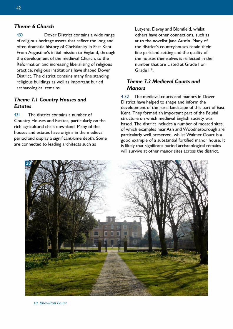
Theme 6 Church
4.30 Dover District contains a wide range
of religious heritage assets that reflect the long and
often dramatic history of Christianity in East Kent.
From Augustine’s initial mission to England, through
the development of the medieval Church, to the
Reformation and increasing liberalising of religious
practice, religious institutions have shaped Dover
District. The district contains many fine standing
religious buildings as well as important buried
archaeological remains.
Theme 7.1 Country Houses and
Estates
4.31 The district contains a number of
Country Houses and Estates, particularly on the
rich agricultural chalk downland. Many of the
houses and estates have origins in the medieval
period and display a significant-time depth. Some
are connected to leading architects such as
Lutyens, Devey and Blomfield, whilst
others have other connections, such as
at to the novelist Jane Austin. Many of
the district’s country houses retain their
fine parkland setting and the quality of
the houses themselves is reflected in the
number that are Listed at Grade I or
Grade II*.
Theme 7.2 Medieval Courts and
Manors
4.32 The medieval courts and manors in Dover
District have helped to shape and inform the
development of the rural landscape of this part of East
Kent. They formed an important part of the Feudal
structure on which medieval English society was
based. The district includes a number of moated sites,
of which examples near Ash and Woodnesborough are
particularly well preserved, whilst Walmer Court is a
good example of a substantial fortified manor house. It
is likely that significant buried archaeological remains
will survive at other manor sites across the district.
10. Knowlton Court.
42
10

Theme 8 Settlement
4.32 The settlements of Dover District
include a number of highlights of considerable
national significance. Amongst these are the
great Roman ports at Dover and
Richborough, the gateway to the province
from mainland Europe. The well preserved
medieval town of Sandwich and the
eighteenth and nineteenth century port town
of Deal are amongst the finest examples of
their type in the country. Stonar lies buried as
an abandoned medieval port, and Dover has
maintained its historic role as one of the
country’s most important ports of entry and
the ‘Gateway to England’. Behind the main
port towns there lies a landscape of smaller
towns, villages and hamlets many of which
have their historic character preserved
through Conservation Areas. The
archaeological record contains widespread
evidence for ancient and historic settlement
across the rural landscape of the district. The
district has also seen the emergence of
planned settlement such as at Aylesford,
Elvington and Mill Hill to serve the emerging
East Kent Coalfield in the early twentieth
century.
Theme 9 Agriculture and farmsteads
Summary
4.33 The district’s historic farmsteads have
played a key role in shaping the character and
local distinctiveness of the rural landscape of
this part of East Kent. They make a
significant and highly varied contribution to
the rural building stock of the area. The
district’s agricultural buildings also reflect the
richness of the agricultural landscape.
Various agricultural industries are also
represented; oasts are a visible reminder of
the former hop industry, whilst the district’s
surviving windmills highlight the arable
importance of this part of Kent.
Theme 10.1 The East Kent Coalfields
4.34 The development of the East Kent
Coalfield from the late nineteenth century
led to a short-lived, but intensive industry
that transformed the otherwise rural
landscape of parts of the district. It is an
industry that has left its mark on the district,
not only as a result of the surviving buildings,
but also from the new areas of settlement
and in particular the communities that it
generated. These new communities have
retained a distinctive character that has
outlived the collieries themselves.
Theme 10.2 Dour Mills & Industry
4.35 The River Dour has provided power
and a water supply for a wide range of
industries that sprang up along its banks.
Corn mills produced flour for the domestic
market as well as serving the large number of
troops often garrisoned in the town; paper
mills made use of the high quality waters of
the Dour to produce paper for the London
market; and breweries used the fine hard
water, filtered through the chalk geology to
produce high quality pale ales. Whilst the
industries on the Dour have largely closed
they have left a number of historic mill
buildings, mill races and evidence for water
management along the length of the Dour.
The Dour and its heritage assets contribute
significantly to the character of Dover,
particularly by preserving the line of the river
that gave the town its origin.
43 Dover District Heritage Strategy

.
Theme 10.3 Quarrying
4.36 Quarrying activity in the district has
been relatively localised in nature and sites
are often small scale and largely below
ground. Nevertheless there are some sites,
such as Stonar Pit and the former Hammill
Brickworks which are particularly visible and
offer significant challenges and opportunities.
Even smaller scale quarries can provide local
markers of Dover’s historic past.
Theme 11 Archaeology
4.37 Dover District contains a wealth of
archaeological sites and monuments from
early prehistory to the twentieth century.
The archaeological remains reflect the
district’s gateway position linking Britain and
the continent. Remains associated with trade,
movement of people, new cultures and ideas
as well relating to the district’s role as a
frontline of defence dominate the area’s
archaeological record. Exceptionally well
preserved archaeological remains are known
in the district from both rural and urban
contexts. The district’s outstanding
archaeological remains help to provide
people with a direct physical link to the past
and bring to life stories and events occurring
at an international, national, regional and local
level.
Theme 12 Built Heritage
4.38 The built heritage of Dover District is
an outstanding resource that stands as a
visible reminder of the area’s rich history.
The district contains important standing
remains ranging in date from the Roman
period to the modern-day. Many of the
district’s Historic Buildings are celebrated for
their aesthetic qualities and are imbued with
a patina of age. The Built Heritage of the
district makes a major contribution to local
character and distinctiveness through the
varied use of materials and the way that
buildings of
different dates and types relate to each other
as well as to the surrounding landscape and
settlement. The district’s built heritage has an
important role to play in future regeneration
proposals, the promotion of sustainable
development and for the economic future of
the district.
Theme 13 Conservation Areas
4.39 There are 57 Conservation Areas in the
district which were designated between 1968
and 1997. Conservation Area status requires
preservation and enhancement of the special
interest, which entails regular surveying and
monitoring of the asset. With limited
information in the form of Conservation
Area Appraisals and Management Plans, a
rapid desk-based overview has been
developed and applied to 33% (19) of the
Conservation Areas to assess their general
condition. The results of the rapid overview,
using a traffic light system to classify their
condition, indicate that 63% (12) of the
Conservation Areas achieved a green light
whilst 31% (6) achieved an amber light,
requiring some enhancement and the
remaining 6% (1) require considerable
enhancement or potential de-designation as
Conservation Areas due to the substantial
loss of their special interest.
11. The Chequer Inn, a Grade II Listed Building in the Ash Conservation Area.
11
44

5 Vulnerabilities

Vulnerability of the Heritage Assets Introduction
5.1 Heritage assets are vulnerable to
change in a number of different ways. The
heritage asset may be affected physically
through a specific action, for example damage
through ploughing or construction activities
or it may be affected passively by change over
time through environmental factors or
neglect.
5.2 The setting of a heritage asset is also
vulnerable to change. The NPPF defines the
setting of a heritage asset as ‘the
surroundings in which a heritage asset is
experienced. Its extent is not fixed and may
change as the asset and its surroundings
evolve. Elements of a setting may make a
positive or negative contribution to the
significance of an asset, may affect the ability
to appreciate that significance or may be
neutral’.
5.3 The following chapter considers the
vulnerability of the district’s heritage assets
to general activities and processes (referred
to here as ‘Generic Vulnerabilities’) and to
specific proposals (referred to as ‘Specific
Vulnerabilities’). As part of the Heritage
Strategy a number of Case Studies have been
considered, where specific proposals have
been examined in more detail to illustrate the
issues that arise and principles that should be
adopted to ensure that the heritage assets
are treated appropriately and opportunities
taken to make best use of them.
Generic Vulnerabilities
5.4 The districts heritage assets are
generally vulnerable to:
• Natural processes such as coastal
erosion, sea level change, change in
hydrology and climate change;
• Rural activities such as ploughing and
use of machinery, changes in farming
regime and leisure use of the
countryside;
• The development and maintenance of
infrastructure such as utilities, power
generation, roads and railways.
• Development of sites including house
building, commercial and industrial
properties, extraction of minerals,
change in landuse, flood and coastal
defence works;
• Change through alteration or economic
decline and neglect;
• Policy shortcomings, designation
thresholds and capacity for monitoring
and enforcement;
• Criminal actions such as arson, theft,
vandalism and anti-social behaviour.
1. Derelict colliery buildings at Snowdown.
46 Dover District Heritage Strategy
1

5.5 These generic vulnerabilities are
described in more detail below with
reference to relevant examples within the
district as appropriate.
Natural Processes
5.6 Coastal erosion – assets are
vulnerable to erosion both removing the land
on which they stand and also burying features
due to material deposition. Cliff collapse
obviously represents a particular threat for
cliff-top installations and other sites. Dover
District Council commissioned a study in
2010 to map coastal change in the district
(Coastal Change Management Area Mapping
Study, Herrington Consulting 2010).The
study identified that the areas most
vulnerable to coastal change (Coastal Change
Management Areas – CCMAs) lie along the
lengths of the White Cliffs between Oldstairs
Bay and Folkestone Warren. Predicted rates
of erosion in these areas are presently up to
0.5 m. per year in the short term rising to up
to 1 m. per year in the long term. A clear
example of the effects of the erosion on
heritage assets can be seen just outside the
district boundary at Folkestone Warren.
There the retaining cliff line has claimed part
of a Roman villa since its partial excavation
early in the twentieth century.
5.7 Sea level change – the risk of sea
incursions threatens sites with flooding,
erosion and exposure to salt water, thus
altering preservation conditions. Low lying
marsh areas, and hence any assets above or
below ground within them, are particularly at
risk due to this natural process. Within the
district low lying land to the north of Deal
around to the Stour is particularly vulnerable.
The low lying lands of the former Wantsum
Sea Channel and the Lydden Sea Valley, both
important historic landscapes, are vulnerable
2. Cliff collapse near St Margaret's. Photo © Stuart Kinnon
2
47

to flooding from rising sea levels. Shoreline
Management Plan policy over this area varies
between areas of holding the present line of
defence to the south of Sandwich Bay Estate
to no active intervention to prevent flooding
between the Estate and the mouth of the
Stour.
5.8 Change in hydrology – changes in the
water table levels pose a risk of sites drying
out, and therefore damaging preserved
organic materials. Sites may also become
waterlogged and so damage structures or
materials previously preserved in dry
conditions. Such risks can arise from water
extraction or from changes in water flow,
even down to site specific changes in these,
such as redirected water flow exposing new
areas to running water. Rapid deterioration
can occur where sites are subjected to
fluctuating changes in water logging. An
example of a site that would be particularly
vulnerable to a change in hydrology would be
the remains of the unexcavated part of the
Dover Bronze Age Boat which was
discovered six metres beneath the streets of
Dover in 1992. Although around half of the
boat was excavated and is now conserved
and on display in Dover Museum, the
remainder fell outside the cofferdam
excavation and still lies within the prehistoric
alluvium of the Dour estuary. There has been
no monitoring put in place to understand
whether a significant change in hydrology has
occurred at the site however the
construction of the adjacent underpass would
suggest some change is likely to have
occurred. As well as other sites within the
deep deposits of Dover town, other areas
particularly vulnerable to hydrological change
would be the alluvial areas of the former
Wantsum Channel, the Lydden Valley and the
river silts of the Stour and Dour valleys.
5.9 Climate change – the threat posed by
climate change is broad and often assumes
the form of associated changes in conditions
affecting sites. For example, changes in climate
facilitate the growth of algae on buildings,
exacerbated by improvements in air quality
due to lower pollution that had previously
retarded such growth. This has greater
implications beyond simply turning buildings
green as it leads to colonisation, particularly
by mosses which can damage the fabric of the
structure. Longer-term climate change might
also permit the advance of invasive species
(plant and animal) that may damage
structures. There is also a general threat to
sites and structures from the increased
likelihood of more extreme weather events,
in the form of flash flooding, high-winds and
lightning strikes. The built heritage of the
district would be particularly vulnerable to
climate change.
Rural activities
5.10 Ploughing and movement of
machinery – all buried archaeological sites in
agricultural land are vulnerable, to varying
degrees, to ploughing, particularly deep
ploughing techniques. Surviving earthworks
are especially vulnerable to even shallow
ploughing or machinery movements across
them. Many of the district’s rural
archaeological sites, particularly those on the
chalk ridges of the North Downs are very
shallowly buried. The numerous finds being
made across the district by metal detectorists
in the main derive from sites that have been
disturbed through ploughing as the majority
of finds are located in the plough soil. A good
illustration is the Ringlemere Gold Cup which
had been damaged by the
3. The Dover Bronze Age Boat on display on Dover Museum. Photo © Dover District Council
48 Dover District Heritage Strategy

impact of a plough prior to its discovery.
Surviving earthworks in woodland are
threatened by forestry machinery
movements, particularly as they may be
unrecognised in areas not previously
surveyed.
5.11 Change in farming regime – the
introduction of new crops or techniques,
either into farming practice in general or
onto land not previously exploited in this
manner, potentially threatens the stability of
conditions for buried archaeological sites.
Deeper rooting crops can damage deposits
or the use of new machinery may introduce
new threats (see above). Additionally, new
practices may lead to the disuse of traditional
buildings and development pressures from
the construction of new warehousing, barns
or livestock shelters. Intensification of farming
methods, larger scale activities (and
machinery) along with diversification can all
lead to changes in current land uses, removal
of existing features, including hedgerows and
the introduction of new features such as
polytunnels, that can have considerable
impact on settings. The trend towards the
sub-division of fields into numerous paddocks
for horse keeping has similar potential
implications, with the introduction of new
characteristics for areas and the construction
of associated structures. The increasing
coverage of the landscape through tree
planting can have an impact on buried
archaeological remains through root
disturbance.
5.12 Leisure use of the countryside –
increased access to the countryside has a
number of impacts, principally arising from
increased traffic (foot, horse or motorised),
often on un-metalled track ways or green
lanes, leading to erosion. Open access land, or
trespassing, also exposes heritage assets to
greater erosion or vulnerability (see crime
section below).
Infrastructure
5.13 Utilities – the installation of new
utilities pipes or cables and their maintenance
can result in considerable ground disturbance
and the breaching of existing boundaries such
as hedgerows. Often the excavation of
trenches in which to lay pipes and cables will
require the removal of plough soil from a
sizeable strip of land or easement exposing
the archaeology below to damage from the
manoeuvring of construction plant. The
construction of overhead power lines can
have an impact on the setting of heritage
assets. In some areas many overhead cables
are being replaced with underground
alternatives. While this can potentially have
historic landscape benefits, the practice does
have an impact on the buried archaeological
assets. Excavation for utilities in the historic
towns and villages and their general
replacement and maintenance can have a
cumulative eroding effect on archaeological
remains preserved under the streets and/or
historic pavements and surfaces themselves.
5.14 Generation – recent years have seen a
rise in the development of new means of
power generation, both on a commercial
scale and for private use. New micro-
generation facilities, wind turbines and solar
panel arrays are being built which as well as
4. Wartime farming on the edge of the White Cliffs of Dover. Photo © IWM (D 17891)
49
4
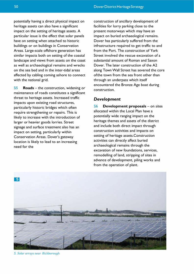
potentially having a direct physical impact on
heritage assets can also have a significant
impact on the setting of heritage assets. A
particular issue is the effect that solar panels
have on setting when attached to historic
buildings or on buildings in Conservation
Areas. Large-scale offshore generation has
similar impacts both on setting of the coastal
landscape and views from assets on the coast
as well as archaeological remains and wrecks
on the sea bed and in the inter-tidal areas
affected by cabling coming ashore to connect
with the national grid.
5.15 Roads – the construction, widening or
maintenance of roads constitutes a significant
threat to heritage assets. Increased traffic
impacts upon existing road structures,
particularly historic bridges which often
require strengthening or repairs. This is
likely to increase with the introduction of
larger or heavier goods lorries. Street
signage and surface treatment also has an
impact on setting, particularly within
Conservation Areas. Dover’s gateway
location is likely to lead to an increasing
need for the
construction of ancillary development of
facilities for lorry parking close to the
present motorways which may have an
impact on buried archaeological remains.
Dover has particularly suffered from the
infrastructure required to get traffic to and
from the Port. The construction of York
Street involved the rescue excavation of a
substantial amount of Roman and Saxon
Dover. The later construction of the A2
along Town Wall Street has severed the core
of the town from the sea front other than
through an underpass which itself
encountered the Bronze Age boat during
construction.
Development
5.16 Development proposals – on sites
allocated within the Local Plan have a
potentially wide ranging impact on the
heritage themes and assets of the district
and include both direct impact through
construction activities and impacts on
setting of heritage assets.Construction
activities can directly affect buried
archaeological remains through the
excavation of new foundations, services,
remodelling of land, stripping of sites in
advance of development, piling works and
from the operation of plant.
5. Solar arrays near Richborough
5
50 Dover District Heritage Strategy

Development can also involve the demolition
of or damage to historic structures, buildings
or features. Impacts that affect the setting of
historic assets or the character of historic
areas can result from the built form of new
development, from activities through the
process of construction and from the
resultant use of the new development.
Although Dover had suffered badly due to
war time damage, town planning in the 60s
and 70s resulted in the redevelopment of the
core of the town centre and in the
construction of imposing structures such as
Burlington House which are today regarded
as incongruous with their surroundings.
Intentions to 'improve' Deal at the time were
resisted and have resulted in the gem that is
the present historic core of the town.
5.17 Enterprise Zone & areas of
permitted development – the
granting of permitted development
rights in areas such as Discovery Park
Enterprise Zone and Dover Harbour
needs to be carefully managed to ensure
that heritage assets are not exposed to
additional pressures through loss of
controls over development and that
suitable mitigation measures can be put
inplace where necessary.
5.18 Development outside of allocation
sites – Development of sites outside those
proposed for allocation in the district’s Site
Allocation process often come forward for
planning permission which have a similar
effect to those in the allocation sites. Small
scale development in areas outside of the
identified allocation sites often occurs. Many
of the towns and villages of the district will
typically see the infilling of vacant plots, the
demolition of dwellings to be replaced by
others and the intensification of properties
through development of garden areas. Also
numerous small-scale domestic
improvements such as extensions to existing
properties occur throughout the district.
These have cumulative impacts on the setting
of historic buildings or settlement areas and
can directly impact on below ground
archaeology. Historic towns such as Sandwich,
with numerous historic buildings and
complex, important buried remains lying
inches from the present ground surface are
particularly vulnerable to small-scale
developments.
5.19 Change in landuse – the withdrawal of
industry exposes built heritage assets to
disuse and neglect (also, see crime below).
Conversely, the intensification of use can
render older structures redundant and
vulnerable to demolition or modification.
This sort of change is a threat to setting, not
only for the immediate site concerned but
for the wider area too. The East Kent
Coalfield is a good example where the
passing of an industry as late as the 1980s has
seen a rapid abandonment of the former
collieries and loss of a large number of the
industrial assets in the district. The same
holds true for military disposal sites within
the district, with assets passing from relative
security or even active use that ensured their
maintenance.
6. Dover Town from Western Heights showing the County Hotel and Burlington House. Photo © Explore Kent
6
51

5.20 Minerals extraction – Although not a
major activity at present in the district
compared to other areas of Kent, quarrying
can have a significant effect on historic
environment assets, not only involving the
physical removal of remains but also
through impacts on the setting of assets
from quarry operations including the
transport of materials. A number of the
district’s more significant archaeological
discoveries have been made during
quarrying operations.
5.21 Waste sites – the reuse of extraction
sites for waste disposal can impact on the
industrial heritage assets that may be present
within the workings. Waste development
can also potentially have an impact on the
setting of heritage assets particularly through
the introduction of transport movements
into and from a site.
5.22 Flood and coastal defence works –
the managed response to flooding or erosion
risks (see above) represent two related
threats. The construction of new defences
can impact directly upon heritage assets,
either burying them or removing them, and
upon their settings. Equally, the decision not
to provide new defences, or to identify flood
overflow areas as part of schemes protecting
other areas, can expose heritage assets to
increased risk of flooding (see above). Much
of the coastal area south of Sandwich Bay
Estate is being actively managed with flood
defences. Areas to the north around the
Stour are being left without intervention
although flood defences for the protection of
the Discovery Park and for the
reinforcement of flood defences around the
historic town of Sandwich have been carried
out.
Change
5.23 Alterations – minor changes to
structures (windows, signage) or properties
(conversion of gardens to parking), permitted
and unpermitted, can have a cumulative
detrimental impact on an area’s setting or on
a specific heritage asset. This gradual erosion
of character is particularly significant within
Conservation Areas. In particular, the
demolition of undesignated buildings,
structures or features has a considerable
knock-on effect.
5.24 Economic decline – areas suffering
from decline or deprivation expose heritage
assets to neglect and impact upon setting of
even the well-maintained assets (see crime
below).
Policy
5.25 Designation thresholds – difficulties in
securing designation for assets comes from
complexities of the system or the high
requirements to merit protection, particularly
where nineteenth and twentieth century
structures are concerned. Designation tends
to concentrate on nationally important
heritage assets meaning that those of regional
or local importance remain vulnerable. In
addition the lack of available resources for
the review of heritage assets and their
identification for possible designation means
that many important remains can be left
vulnerable.
5.26 Monitoring and enforcement – while
policies may be in place to ensure the
protection of heritage assets, resources are
often insufficient to ensure the regular
monitoring and enforcement of those
policies. Shortcomings in the knowledge,
information available to and training of those
who recommend and make decisions that
affect heritage assets can be detrimental.
Crime
5.27 Arson – built heritage assets are
vulnerable to fire, particularly those which
are unoccupied or already in a dilapidated
state. Assets located in accessible areas are
more vulnerable but those in more remote
areas can also suffer as they are less
observed.
52 Dover District Heritage Strategy

5.32 The above scales have been applied
through professional judgement rather than
any particular formulaic approach, however
the following reasoning has been applied as
far as practicable:
5.28 Theft – the theft of materials from built
heritage assets is a major problem,
particularly in relation to metal roofing or
safety features, which can be stripped for
their scrap value. Such theft exposes the
building to the elements or renders it unsafe.
Unauthorised metal detecting also
constitutes theft as well as damaging to
buried heritage assets where not carried out
responsibly.
5.29 Vandalism – Built heritage assets can
be vulnerable to varying degrees to
vandalism, either graffiti or wilful damage.
Disused or already damaged structures are
particularly vulnerable. Interpretation panels
are also frequently targeted and this
threatens the value or understanding of the
associated heritage assets.
5.30 Anti-social behaviour – anti-social
behaviour may have no physical impact on
heritage assets but can still be detrimental. By
making areas unwelcoming or even
dangerous, people can be discouraged from
visiting. This in turn makes sites vulnerable to
other forms of crime as there are fewer
visitors likely to discourage damage or
defacement.
Generic Vulnerabilities by Theme 5.31 The following table sets out the
vulnerability of the themes identified within
the Heritage Strategy to change through the
'generic vulnerabilities' set out above. The
table uses the following five point scale of
vulnerability based on the potential effect
on the theme as a whole.
7. Vandalism of historic sites.
• The theme is highly vulnerable to
change where there is likely to be a long term
major change to the theme as a whole or
loss of significant assets.
• The theme is considerably vulnerable
to change where there is likely to be long
term significant change to the theme as a
whole, loss of assets or significant impact on
the setting of the assets
• The theme is moderately vulnerable
to change where there is likely to be a
moderate level of change to the theme
through loss of some assets or some impact
on setting
• The theme is slightly vulnerable to
change where there is likely to be a slight
level of change to some assets or slight
impact on setting
• The theme is unlikely to be vulnerable to
change.
53
7

54

Case studies
Introduction to the Case Studies and
their selection
5.33 A number of case studies have been
selected to illustrate ways in which the
Heritage Strategy work can be used to
identify opportunities and identify the
sensitivity of specific proposals. These
are:
1 – Discovery Park Enterprise Zone. This
case study has examined the area which has
been announced for designation as an
Enterprise Zone at the former Pfizer site in
Sandwich. The work considers the heritage
potential of the site and opportunities for its
use together with parameters and guiding
principles for future permitted
development.
2 – North Deal. This case study has
examined the heritage potential of an area to
the north of Deal and in particular around
Sholden. Proposals for access, new
development and drainage infrastructure have
been considered within the area.
Opportunities for use and enhancement of
the heritage assets and potential sensitivities
have been identified together with a number
of guiding principles.
3 – Fort Burgoyne & Connaught
Barracks. This case study has examined the
area of the former Connaught Barracks to
the north of Dover. The site includes the
nineteenth century Fort Burgoyne and
casemented barracks as well as the later
barracks site. The case study considers the
heritage potential of the site opportunities
arising from potential residential
development proposals and vulnerabilities
that should be addressed. The case study
sets out a number of recommendations and
development – Deal Conservation
Areas. This case study examines the Middle
Street Conservation Area in Deal and
adjacent Conservation Areas to illustrate
the positive effect that Article 4(1)
Direction has had on preserving the historic
character of the area.
5.34 The Case Studies are set out in detail in
Appendix 3 of the Strategy.
8. Discovery Park © Discovery Park 9. Fort Burgoyne © The Land Trust
55
8
9

6 Opportunities

Opportunities Introduction
6.1 The historic environment of Dover
District offers great potential as a resource
for enhancing the quality of life in the district.
It can act as a framework for regeneration,
complementing and supporting the economic
development of Dover. This can help produce
higher quality and more sustainable
development that is successfully integrated
into the life of the district. The historic
environment can also play a key role in social
regeneration and in the cultural offering of
the district. Successful heritage-led
regeneration, acting in partnership with
community projects, can help to connect
people with their urban and rural landscapes,
with their heritage and with each other. The
linking of heritage with the culture and arts
sector can provide significant benefits
together and be a strong catalyst to creating
wealth and regeneration. In this section the
main ways in which the historic environment
can contribute to regeneration, to Dover’s
economy and to the district’s social well-
being will be reviewed. The final section
brings together the opportunities identified in
each of the thematic papers.
The potential of the historic environment to act as a catalyst for economic and social regeneration 6.2 Successful regeneration has to have a
lasting long-term positive effect on places and
the communities that live in them. It is not
just about improving the physical fabric of a
place; it is about bringing about social
cohesion, encouraging economic growth and
restoring vibrancy to communities. The
potential of the historic environment to form
a keystone to the district’s regeneration is
recognised and as such Dover’s rich heritage
should play a key role in any regeneration
scheme in the district. The incorporation of
heritage as a keystone in a holistic
regeneration approach brings a number of
benefits.
Creating a sense of place
6.3 Whether in an urban or rural
environment, the historic environment
creates a ‘sense of place’; it adds character
and distinctiveness to towns and villages that
may be otherwise essentially similar. The
buildings, open spaces, historic features and
patterns of roads and lanes are what
ultimately define the character of settlements.
It is therefore important that any change is
sensitive to this character, adding to and
developing distinctiveness rather than
diminishing it and creating uniformity or
blandness. Although designated heritage
assets and Conservation Areas will be central
to this process, the historic environment can
hold meanings and memories for a
community that go beyond the architectural,
archaeological or historical importance of
designated assets.
6.4 Heritage assets can act as a mechanism
for bringing groups and communities
together. People want to be proud of where
they live and the historic environment can act
as a catalyst for engendering and reawakening
local pride by strengthening and celebrating
the self image of communities. The heritage
of a place is an identifying link that brings
people together.
1. The Royal Marines Barracks, Deal.
1
57 Dover District Heritage Strategy

Re-use of heritage assets
6.5 Heritage-led regeneration can take a
number of forms. In its simplest mode it
might involve bringing a historic building back
into use or refurbishing a historic property
that has suffered from neglect. More complex
programmes can involve refurbishing
industrial complexes or barrack buildings as
at Deal Barracks. Re-using existing buildings is
a simple way of achieving sustainability whilst
bringing the added benefit of reinforcing the
sense of place that they engender.
6.6 The historic environment has a
significant role to play in the conservation of
resources required for development as it may
take fewer overall resources to adapt an old
building than to demolish it and build a
completely new one. Some modern building
materials may also have limited lifespan
compared to traditional materials such as
stone, brick and tile. Historic England has
produced guidance (‘Climate Change and the
Historic Environment’, 2008) that reviews the
threats to the historic environment posed by
climate change. The guidance also
demonstrates that historic structures,
settlements and landscapes can in fact be
more resilient in the face of climate change
and sometimes more energy efficient, than
more modern structures and settlements.
6.7 Re-use of existing buildings can also be
economically beneficial. It may be less
expensive to refurbish or convert an old
structure than to build anew. By contrast,
historic buildings are often considered more
desirable than new buildings and thus have
the potential to carry a price premium.
6.8 Heritage-led regeneration is about
more than just re-using historic buildings.
Other assets such as parks and gardens,
municipal spaces, sea-front promenades,
bridges, piers, the patterns of roads and lanes,
historic features such as walls, road signs and
surfaces and also more ephemeral historic
elements such as house, pub or building
names etc also have key roles to play. All of
these can together create a historic
‘framework’ for the settlement. When new
extensions to the settlement are being
planned it may be that the majority of these
features are not found in the development
area as they will naturally be concentrated in
the historic core. It is likely, however, that
some of them will be present and these
enable the new development to be linked to
the historic framework of the rest of the
town.
Adding value to new development
6.9 Heritage-led regeneration adds value to
development projects. It is striking that in
most towns it is the heritage-led
developments that are among the most
prestigious and financially valuable. Examples
in Dover District include the Deal Barracks
development, the Tannery Lane development
in Sandwich and the Crabble Paper Mill
development in Dover. Where regeneration
is led by large-scale new development, the
historic environment can help to avoid a
sense of a development scheme being
artificial and seemingly dropped into a
landscape. These can also have the advantage
of accommodating large scale new housing
without major intrusion into the existing
infrastructure and the local community.
2. Dover Marine Railway Station now houses the harbour cruise liner terminal. © Dover District Council
58
2

Durability of regeneration
6.10 The historic environment can also help
to ensure that regeneration is durable. Many
examples of failed regeneration are where
development has taken place entirely
independent of the local environment. The
‘newness’ appeals for a period but gradually
the buildings become older and less
fashionable, the economic imperative that
called the development into being passes and
the development begins to decline, at worst
gradually degenerating into a ‘sink estate’.
The development is then demolished and
replaced and the process begins again.
Heritage-led regeneration helps to avoid this.
By integrating development into the historic
‘framework’ of a place it acquires a greater
sense of belonging and thereby resilience.
The historic features also help to break up
the development’s design thus creating
‘breathing space’ in contrast to developments
without heritage features which can often appear
monotonous. The historic framework is also a
permanent fixture of the development
providing a frame of reference for
evolutionary change.
By using heritage to create attractive
environments this durability is enhanced as
external investment is continually drawn in
enabling it to be refreshed and to grow.
Reduced social exclusion
6.11 Heritage-led regeneration also has a
role to play in helping to reduce social
exclusion in modern developments. Historic
buildings come in all shapes and sizes. Just as
they can break up the monotonous shape of
a modern development so they can help to
break up the monotony of the social
structures. For example, most of the housing
around Crabble Paper Mill consists of
detached and semi-detached houses. The
residential conversion of the old mill buildings
has created primarily 1 and 2-bedroom flats
which will have a somewhat different
demographic. Retaining older buildings such
as terraced housing in the centre of towns
helps to conserve the character of the
settlement. In addition, however, these houses
are often less expensive than new build
equivalents and so by conserving them a
more diverse population is allowed than if
they were replaced.
6.12 Retaining historic buildings and features
also helps older people to retain their own
sense of place in an area and thereby brings
the generations together. Where those
features relate to people’s former
employment this also helps to tell the story
of an area which can be developed for
educational groups to further embed new
development within the older historic
framework. Such changes must be affordable
however. Whilst ‘gentrification’ of a place
may lead to an improvement in the market
value of properties care must be taken to
ensure that this doesn’t end up pricing
sections of the existing community out and
lead to disenfranchisement. Likewise where
a ready use cannot be found for a historic
building there is the danger that it will
become neglected or eventually derelict and
will act as a source of disenchantment. It is
important therefore that innovative and
transformational solutions are sought to
bring historic buildings and sites back into
use.
3. Beach front properties in Deal. Photo © Explore Kent
3
66 Dover District Heritage Strategy 59

Access to Dover’s heritage and the role of tourism in Dover’s economy
Current public access to Dover’s
heritage
6.13 The vast majority of Dover District’s
heritage is in fact accessible to the public, at
least externally. Historic buildings can be seen
from the roads and footpaths. Historic
features such as walls, memorials, street and
building names and street furniture can be
seen easily in urban centres and the historic
landscape can be explored via the District’s
extensive public rights of way network. Some
of these sites may be public buildings (e.g.
Maison Dieu, Dover) or in publicly accessible
areas (e.g. Archcliffe Fort). For most people,
most of the time, this represents their
interaction with Dover’s heritage. For
residents and visitors alike it is this that
defines their perceptions of the district as
much as the key sites and landscapes that are
more striking or are interpreted. The
importance of maintaining the quality of this
‘background’ heritage cannot be overstated,
therefore, and careful conservation through
Listed Building consents, planning
applications within conservation areas (based
on full Conservation Area Appraisals) and
archaeological and other conditions, will be
essential to retain Dover’s special quality.
6.14 Some sites are, however, presented more formally
to the public, involve greater or lesser degrees of
access and interpretation and are actively
promoted as attractions.
Paying sites
6.15 There are a number of heritage sites
which charge admission. Several of the most
prominent are operated by major national
organisations (e.g. English Heritage or the
National Trust) but several are operated by
local community trusts or partnerships.
Examples of paying heritage sites in Dover
District include:
• Dover Castle (including Princess of
Wales Royal Regiment Museum)
(300,000 visitors per year)
• Walmer Castle (65,000 visitors per
year)
• Deal Castle (30,000 visitors per year)
• Richborough Castle (14,640 visitors per
year)
• Roman ‘Painted House’
• Crabble Mill
• Timeball Museum, Deal
• South Foreland Lighthouse (12,870 visitors per year)
60 Dover District Heritage Strategy
4
5

• Chillenden Windmill
• White Mill Rural Heritage Centre
• East Kent Light Railway
• Dover Museum
• Deal Maritime Museum
• Dover Transport Museum.
Non-paying sites
6.16 There are also a number of heritage
sites that do not charge for admission, such
as:
• Knights Templar Church,Western
Heights
• Dover Western Heights including the
Drop Redoubt and St Martin’s Battery
• Sandwich Guildhall Museum
• The Grand Shaft, Dover (limited ‘open-
days’ only)
• Dover Discovery Centre (including the
remains of St Martin le Grand, the
Classis Britannica Fort and the Old
Market Hall).
• Bleriot Memorial
• Dover’s medieval and later churches
• Sites accompanied by interpretation
panels or plaques
• Battle of Britain Memorial, Capel-le-
Ferne
• The Women’s Land Army Museum,
Little Farthingloe
• St Margaret’s Museum, St Margaret’s at
Cliffe.
Heritage Trails
6.17 Across the District there are also a
wide range of heritage trails, from short
circular walks to long-distance walking routes.
Examples of such trails in the District include:
• Coastal Walk,White Cliffs of Dover
(236,700 visitors to the visitor centre
each year). National Trust
• Saxon Shore Way long distance walking
route
• Western Heights Trails (three trails (2 –
6 miles) as well as two history trails:
The St Martins Battery Trail (0.5 miles)
and the Grand Shaft Barrack Trail (1
mile).White Cliffs Countryside
Partnership
• Frontline Britain Trail, St Margaret’s at
Cliffe.White Cliffs Countryside
Partnership
• The Miner’s Way Trail. Coalfield
Heritage Initiative
4. The Dover Patrol Memorial.
5. Heritage walking trails.
6 7
61

• The North Downs Way long distance
walking route
• St Augustine Trail
• The Timeball & Telegraph Trail.
Inaccessible
6.18 A number of heritage assets remain
inaccessible to the public.These include:
• Private houses or other domestic or
agricultural buildings located out of
sight from public rights of way
• Bunkers, pillboxes etc located on
private land
• Shipwrecks below low water mark
• Buried archaeological sites
• Some churches or chapels e.g. Oxney
Church
• Industrial complexes e.g. Snowdown
Colliery site.
Current heritage tourism in Dover
District
6.19 Tourism is the fifth biggest industry in
the UK, worth almost £12bn a year1.The
additional benefits of this direct investment
are even more substantial, generating some
£21bn.The industry employs almost 200,000
people and is very much a growth industry
being predicted to rise annually by 2.6%
between 2009 and 20182. It is estimated 40%
of employment in tourism depends directly
on a high quality built and natural
environment, rising to between 60% and 70%
in more rural areas3.
6.20 The role of heritage in those figures is
particularly significant. History and the built
heritage is the strongest single driver for
overseas tourists 30% of whom say that the
UK’s heritage is the main reason for visiting
the country4. 80% of all foreign visitors visit
heritage sites while they are here5.
6.21 Nevertheless, we shouldn’t forget that
far and away the biggest sector in tourism is
the domestic market. Only 17% of all visitors
to heritage sites are foreign – the vast
majority are British6. Some 69% of all UK
adults visited a heritage site last year. Finally, it
shouldn’t be forgotten how important the
tourist spend is to the communities in which
historic sites lie. Of every £1 spent on
tourism 69p is spent away from the site itself
on accommodation, meals, etc7.
6.22 Within Kent tourism is worth some
£2.5bn per year and provides 50,000 jobs in
the county. This represents an income to the
county equal to £1,755 for each man, woman
and child in the county.
6.23 Within Dover District, the importance
of tourism is similarly clear:
• 422,000 overnight tourism staying trips
were made to Dover in 20178. Of these
trips, domestic visitors made 80% of
trips (336,000) and overseas visitors
made 20% of trips (86,000).
• £88,827,000 was spent by staying
visitors on their trip to Dover in 2017.
Of this expenditure, 71% was spent by
domestic visitors and 29% by overseas
visitors.
6. Wanstone Battery - Second World War heritage on private land.
62 Dover District Heritage Strategy
8

• 4.17 million Tourism day trips were made to
Dover in 2017, generating a further £126,994,000
trip expenditure.
6.24 In total, around £215,821,000 was spent
on trips to Dover in 2017 by staying and day
visitors.
6.25 This income supported 4,212 FTE jobs
and 5,796 Actual jobs. Overall it is estimated
that tourism expenditure supported 17% of
local employment in Dover.
The potential of Dover’s heritage for public access and tourism
Perceptions of east Kent
6.26 In August 2007 Kent Tourism carried
out research into public perceptions of Kent
generally and east Kent in particular (Dover,
Thanet, Shepway and Canterbury Districts).
This highlighted some key issues for how
east Kent is regarded by respondents, all of
whom live in the south-east of England9.
• Although Kent was identified as a
‘historical’ region (50% respondents),
east Kent was slightly less so (41%)
• 45% of respondents
associated Kent with castles,
as compared with 37% when
asked about east Kent
• 24% identified Kent as
‘touristy’ as compared with
30% for east Kent
• 37% thought there were a
range of gardens to visit in
Kent but only 26% thought
this true of east Kent
• East Kent was, however, more
strongly associated with the
phrases ‘gateway to Europe’,
‘stunning coastline’, ‘seaside
resorts’, and ‘beaches’
• Of seventeen coastal
destinations in the south-east
Deal and Sandwich were located
in the bottom five when tested
for awareness. Dover was,
however, rated second.
6.27 Dover has a similar perception to
Folkestone, although Dover has some clearer
perceptions in terms of history and scenery.
This is undoubtedly linked to Dover Castle
and the White Cliffs and respondents’
knowledge of these two attractions
7. Heritage interpretation panel on Dover Seafront.
8. Dover Museum.
9
63
10

6.28 It is seen as a destination that is easy to
get to and somewhat touristy and like many
of the East Kent destinations is seen as
friendly and traditional in an old-fashioned
way.
6.29 Deal has a similar emotional perception
to Whitstable and Broadstairs in terms of
old-fashioned, traditional and friendly but is
perceived as offering more in the way of
historical or heritage attractions both close
to the town centre and on the approaches to
the town. It is seen as a place to get an
authentic feel of Kent in a charming town.
6.30 Sandwich is seen as a traditional, old-
fashioned Kent town offering history and
heritage. It is perceived as a place with
stunning scenery and interesting architecture,
being a medieval city with the remains of the
old town walls and the Toll Bridge/ Barbican.
There are still many people who need to be
informed about what Sandwich has to offer
as just over a third of people (36%) strongly
associated the town with history and heritage
indicating that the majority are not sure what
it offers from a historical perspective. It is
seen as a place to explore the surrounding
area with opportunities for walking or
cycling.
6.31 Although the research focused on east
Kent in general, rather than just Dover
District, it suggests that there are some key
perception challenges that must be
overcome.
6.32 East Kent is arguably the most
‘historical’ part of Kent, seeing earlier
introductions of many site types and
processes than in the rest of the county. For
the Roman, Anglo-Saxon and Medieval
periods many of the earliest structures in
England are to be found in east Kent and in
particular Dover District, for example the
Saxon Shore Forts, Roman Pharos and
‘Painted House’ in Dover town. The region
contains Canterbury, a World Heritage Site
and one of the most well-known English
centres of heritage in the world. The region
also features disproportionately strongly in
terms of defence heritage such as at Dover
Castle, the Henrician Castles of the Downs,
the forts of the eighteenth and nineteenth
centuries and the two World Wars. The
perception that east Kent is less ‘historical’
and less associated with castles is thus
particularly disappointing and suggests that
significant work needs to be done to improve
the image of the district as it exists, even
without further improvement in public access
to heritage.
Areas of potential development for public access to heritage 6.33 There are a number of approaches that
could be considered to increase public access
to heritage in Dover District, whether by
residents or by tourists.
Improvement of the current tourist
offer
6.34 Many of the tourist attractions in
Dover District are superbly presented. The
range of activities and areas of interest
provided for by Dover Castle is unlikely to be
matched by many tourist attractions in
England. The site covers a wide range of
periods including Roman, Saxon, Medieval
post-Medieval and Second World War. For
each of these there is interpretation that is
regularly updated using a range of technical
methods and approaches. The site offers a
variety of environments from medieval
masonry in the keep, open spaces with great
views from the top of the keep and the
ramparts and the oppressive atmosphere of
the tunnels. Numerous staff are on hand to
guide visitors and there are excellent
refreshment and dining facilities as well as
good (if increasingly pressed) on-site parking.
64

6.35 Few sites can expect to match this offer
and within the district there are a number of
very well presented sites that need not be
reviewed here. There are, however, a number
of sites that might benefit from additional
support or investment to allow more
sustained opening hours, refresh of
interpretation, parking facilities, refreshments
and greater networking with other
attractions in the area.
Development of new sites as tourist
attractions
6.36 Within Dover District there are a
number of sites that might be developed
further as tourist attractions.
6.37 Dover Western Heights – The site
attracts a large number of visitors for its
occasional open days in the Drop Redoubt
and the Western Heights Preservation Trust
9. The Drop Redoubt, Dover Western Heights.
arrange a number of activities each year. The
site also receives a large (but unknown)
number of visitors via the car-parks at Drop
Redoubt Road, The North Entrance and at St
Martin’s Battery where elements of the
twentieth century defences can still be seen.
It is likely that other visitors explore much of
the remains that can be seen on an informal
basis. Given the size of the site and potential
management and access issues, it may be
necessary to be selective about which
elements of the site are fully open-up to the
public.
6.38 Swingate to St Margaret’s Second
World War sites – Along the cliffs east of
Dover are a great number of Second World
War bunkers, gun positions and anti-aircraft
gun sites as well as a radar station. They are
of great interest to enthusiasts but only
occasionally made accessible to visitors. It is
rare for such a concentration of such sites to
exist anywhere in the UK. These particular
sites are especially interesting to visitors in
that they ‘saw action’ during the War unlike
most sites of the period.
11
65

6.39 Port Facilities, Dover – The Port is
Dover’s strongest defining feature today and
contains numerous historic structures
including the harbour breakwaters, the Dover
Turret, the basins and wharfs and Admiralty
Pier Station. Providing access to the port
facilities would help to integrate the port
better with the town but it is recognised that
the Port is an operational and secure area
where opportunities for access are a
challenge. Future redevelopment of the Port
may provide opportunities to increase access
to its heritage assets and should be
encouraged as far as is possible.
6.40 The district needs to strengthen its
overall heritage brand to attract visitors on a
national and international scale. Although
Dover in particular is a main point for entry
to cross channel travellers and passengers
using the cruise terminal, it is more often
than not overlooked as a visitor destination
with locations such as Leeds Castle,
Canterbury and London being preferred.
The numerous individual heritage assets
need to be packaged in a way that captures
the attention of those travelling through the
District and using the Port and encourages
visits from elsewhere in the region,
particularly for overnight stays. The district
should also seek opportunities to work with
neighbouring authorities to better promote
and link the heritage offer of the east Kent
area as a whole.
Thematic development of heritage assets 6.41 In addition to the development and
promotion of individual sites there are a
number of themes that might be developed
for visitors. These would link sites that are
formally presented to the public already with
those that are not and would thereby help to
pass visitors on from one site to the next
while taking them into new areas of the
district. Examples of these could be:
6.42 Coastal defence – Dover District has
defensive fortifications from a wide range of
periods, many of which can be visited and
some that are already well prepared to
receive visitors. By linking Richborough Fort,
Dover Castle and Sandwich town walls, Deal
and Walmer Castles, the Western Heights and
the Second World War sites along the cliffs
east of Dover, a coastal defence network
could be developed that spans much of the
district’s past. Such a network could readily
be developed in partnership with the adjacent
districts and in particular along the coast line
around Folkestone.
6.43 The churches of Dover – Dover
District has a number of fine early churches
or church sites that could be linked together.
These include the early church(es) in
Richborough Fort, St Mary in Castro,
Barfreston Church, St Mary’s,Wingham, the
10. The Church of St Nicholas, Ash.
12
66 Dover District Heritage Strategy
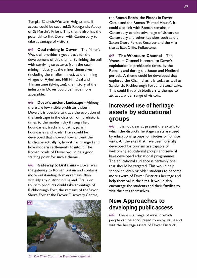
Templar Church,Western Heights and, if
access could be secured, St Radegund’s Abbey
or St Martin’s Priory. This theme also has the
potential to link Dover with Canterbury to
take advantage of visitors.
6.44 Coal mining in Dover – The Miner’s
Way trail provides a good basis for the
development of this theme. By linking the trail
with surviving structures from the coal-
mining industry at the mines themselves
(including the smaller mines), at the mining
villages of Aylesham, Mill Hill Deal and
Tilmanstone (Elvington), the history of the
industry in Dover could be made more
accessible.
6.45 Dover’s ancient landscape – Although
there are few visible prehistoric sites in
Dover, it is possible to trace the evolution of
the landscape in the district from prehistoric
times to the modern day through field
boundaries, tracks and paths, parish
boundaries and roads. Trails could be
developed that showed how ancient the
landscape actually is, how it has changed and
how modern settlements fit into it. The
Roman roads of Dover would be a good
starting point for such a theme.
6.46 Gateway to Britannia – Dover was
the gateway to Roman Britain and contains
more outstanding Roman remains than
virtually any district in England. Trails or
tourism products could take advantage of
Richborough Fort, the remains of the Saxon
Shore Fort at the Dover Discovery Centre,
the Roman Roads, the Pharos in Dover
Castle and the Roman ‘Painted House’. It
could also link with Roman remains in
Canterbury to take advantage of visitors to
Canterbury and other key sites such as the
Saxon Shore Fort at Reculver and the villa
site at East Cliffe, Folkestone.
6.47 The Wantsum Channel – The
Wantsum Channel is central to Dover’s
exploitation in prehistoric times, by the
Romans and during the Saxon and Medieval
periods. A theme could be developed that
explored the Channel as it is today as well as
Sandwich, Richborough Fort and Stonar Lake.
This could link with biodiversity themes to
attract a wider range of visitors.
Increased use of heritage assets by educational groups 6.48 It is not clear at present the extent to
which the district’s heritage assets are used
by educational groups for studies or for site
visits. All the sites that have been formally
developed for tourism are capable of
welcoming educational groups and several
have developed educational programmes.
The educational audience is certainly one
that should be targeted. This would help
school children or older students to become
more aware of Dover District’s heritage and
help them value the sites. It would also
encourage the students and their families to
visit the sites themselves.
New Approaches to developing public access 6.49 There is a range of ways in which
people can be encouraged to enjoy, value and
visit the heritage assets of Dover District.
11. The River Stour and Wantsum Channel.
67
13

Complementary themes
6.50 The ‘Heritage Counts’ survey of 2009
revealed that in that year the number of
visitors to castles and forts did not rise at
all whereas visits to visitor centres or
heritage centres rose by 6%.This may
suggest that people want more diverse
experiences from their days out than simply
visiting ‘pure’ heritage sites. This may be
particularly true for families. One way to
meet this need is to develop alternative
themes around the same site. For example,
the National Trust White Cliffs site
combines heritage interests with
biodiversity and natural environment
interests and thereby attracts a great
number of visitors each year. Many of the other themes in the district’s past will lend
themselves to a similar approach allowing
them to access the visitors making some of
the 1.2 billion visits made to the UK’s
countryside every year10.
Community Projects
6.51 One approach to engaging people with
their heritage is to involve them in its
identification, study and promotion. An
excellent example of this is the ‘Forgotten
Front Line’ project developed by a team led
by Mark Harrison in the north of Canterbury
District. Using their own research, combined
with the results of a Kent County Council
survey of twentieth century military and civil
defence sites, the team produced an
exhibition. The information about sites was
combined with oral history from local people
and an innovative use of 1940s aerial
photographs. The exhibition was
complemented with history tours where
visitors were taken to the sites featured in
the exhibition and met the local people who
had contributed. Effective media promotion
saw the exhibition visited by 6,000 people at
Whitstable Museum, 19,000 more at Quex
Park and a few thousand more at the Royal
Naval College.
6.52 The project was similar in approach to
projects such as the Coalfields Heritage
Initiative Kent (CHIK) project and this
demonstrates the applicability of the
approach across a range of different themes.
Many of the opportunities identified in the
thematic papers (see Appendix 1) include
opportunities for engagement with the local
community so that people can become
involved in understanding and conserving
their heritage. These projects have the
additional benefits of being flexible,
inexpensive to operate (compared with the
costs of opening sites or museums to
visitors) and responsive to local people.
New technology
6.53 The same spirit of cost effectiveness
also suggests that wider use should be made
of new technologies. Mobile technology, for
example in the form of media players or
smart phones, allows information to be
packaged in a way that is attractive and
elegant but also relatively inexpensive. Using
this kind of technology the information that
would be traditionally carried on
interpretation panels can be made available to
people in advance of their visits or can be
downloaded ‘in the field’. They can then
combine it with other information from
other projects or with applications providing
catering or accommodation information so
that all their information needs can be met. A
much great quantity of information can
therefore be provided, better tailored to
visitors, often at a reduced cost, than could
be met by traditional panels without the
12. Walking along the Miner's Way Trail. Photo © Coalfields Heritage Initiative Kent / Dover District Council
68 Dover District Heritage Strategy
14

equally traditional threat of vandalism. Co-
ordinated use of new technology, for example
with Explore Kent for countryside access,
would help to ensure that wider groups
benefit from heritage information and that
the district’s heritage forms part of a more
diverse experience.
6.54 In a similar vein tourist attractions of
the future will have to be more flexible about
how they communicate with the public. The
advent of Social Media – Facebook, Twitter,
etc has meant that word of mouth has, for
many people, been replaced by its digital
equivalent, with the difference that word
travels far faster and wider across the
internet than by any previous means. This
provides a great opportunity for those trying
to promote attractions and events in a cost
effective way. It allows them to link with
other projects, groups and initiatives thus
allowing sites to target their marketing far
more effectively than can be achieved by
conventional media.
6.55 CDs are hardly new technology but
they still have a role to play in packaging
information for tourists in a cost-effective but
flexible way. An example of this is the ‘Drive
the Battle of Britain’ driving tour produced by
Kent County Council in 2005.The CD guided
visitors around a range of Battle of Britain
sites in Dover and Shepway. The principle
underlying the CD remains true today – that
a set of sites can be linked by a common
theme far more effectively together than
separately. It is particularly useful for sites
that have no interpretation materials at all
and would suit many of the themes listed
above.
‘Remote’ access
6.56 Although access to heritage sites tends
to focus on physical access, it should be
remembered that for many people physical
access to sites may not be possible. The
district’s heritage is nonetheless their
heritage too and it is essential that websites
and other resources are fully developed to
connect people with the sites, help them to
explore them remotely and understand the
history and the context. It is remarkable how
many tourist attractions, even those run by
very large national organisations, have
websites that provide virtually no information
about the sites except such as may be
required for visitors – opening hours, prices,
events etc.
1Economic impact of heritage tourism, Oxford Economics, 2009.This includes museums and green heritage sites as well as visits to the built historic environment 2 The Economic Case for the Visitor Economy, Deloitte, 2008 3Valuing our Environment, National Trust 4Internal English Heritage performance figures 12/2/2010 5ANHOLT-GMI Nation Brand Index,Visit Britain Nov 2007 6VisitEngland Survey of Visitors to Visitor Attraction 2008 7Investing in success: Heritage and the UK tourism economy 8White Cliffs Country: Dover, Deal & Sandwich:VisitKent research document 9Kent Tourism Perception Research Prepared by Arkenford Ltd for Kent Tourism August 2007 10Visit Kent: Economic Impact of Tourism Dover District 2017
69

© Andrew Mayfield
7 Taking the Strategy Forward

Taking the Heritage Strategy Forward Introduction
7.1 The Government recognises the role
that the historic environment can play in
delivering the sustainable development
agenda. The National Planning Policy
Framework (NPPF) (paragraphs 7 and 8)
recognises that there are three dimensions to
sustainable development: economic, social
and environmental. It goes onto state that
part of the planning system’s environmental
role is ‘to contribute to protecting and
enhancing our natural, built and historic
environment’. Environmental gains should be
sought jointly and simultaneously with
economic and social gains through the
planning system as the dimensions are
mutually dependent and not exclusive.
7.2 The sustainable development agenda
needs to be reflected in the Local Plan.
The NPPF further states that
‘184. Heritage assets range from sites and
buildings of local historic value to those of the
highest significance such as World Heritage Sites
which are internationally recognised to be of
Outstanding Universal Value. These assets are an
irreplaceable resource, and should be conserved
in a manner appropriate to their significance, so
that they can be enjoyed for their contribution to
the quality of life of existing and future
generations.
185. Plans should set out a positive strategy for the
conservation and enjoyment of the historic environment,
including heritage assets most at risk through neglect,
decay or other threats. This strategy should take into
account:
• the desirability of sustaining and enhancing
the significance of heritage assets and
putting them to viable uses consistent with
their conservation;
• the wider social, cultural, economic and
environmental benefits that conservation of
the historic environment can bring;
• the desirability of new development making
a positive contribution to local character
and distinctiveness; and
• opportunities to draw on the contribution
made by the historic environment to the
character of a place.’
7.3 The Heritage Strategy has described
the extraordinarily rich history of Dover
District and its vast wealth of heritage assets.
Alongside iconic assets such as Dover Castle,
Richborough, medieval Sandwich and the post
medieval townscape of Deal, numerous sites
of national, regional and local importance
exist, some designated but many not.
Together these heritage assets provide the
district with its distinctive historic character
and have shaped the place that it is today, a
place greatly valued by residents and visitors
alike.
7.4 The historic environment is one of the
district’s most valuable assets; it can and
must play a significant role in the growth and
regeneration agenda for the district. It should
be used in a positive and proactive way and
not become seen as an obstacle to the
district realising its potential.
1. Chillenden Windmill.
71 Dover District Heritage Strategy

Objectives 7.5 The Heritage Strategy (Chapter 6) has
described the ways in which the Historic
Environment can act as a catalyst for social
and economic regeneration through creating
a valued ‘sense of place’, the re-use of
heritage assets, adding value to new
development, ensuring that regeneration is
durable and through helping to reduce social
exclusion. There are good examples in the
district where heritage-led regeneration and
re-use of historic buildings within
development have been used to create a
valued sense of place: Perhaps the most
evident is the redevelopment of the former
Royal Marines barracks in Deal where many
of the buildings have been retained and
converted for a mix of uses creating an area
with undoubted historic qualities; in
Sandwich, the development of Tannery Close
has responded well to the strong historic
character of Sandwich and ensured that the
development fits into the townscape and is
potentially more durable; the re-use of the
former secondary school at Aylesham for a
community centre and workshops has
secured a future for one of the East Kent
Coalfield’s heritage assets as a valued
community resource; elsewhere the former
coal mining tips at Betteshanger Colliery have
been transformed into Fowlmead Country
Park.
7.6 The future regeneration of the district
can benefit from re-use of its heritage assets.
The extensive post-medieval fortifications at
Dover Western Heights can play a significant
role in Dover’s regeneration as a
complementary heritage asset to Dover
Castle. The Dover Western Heights provide
a considerable challenge in ensuring that
future development and proposals for change
there are appropriate to the site and means
are found to conserve and enhance the
heritage asset. Similarly Fort Burgoyne
should contribute significantly to the
redevelopment of the former Connaught
Barracks site.
Other significant opportunities are provided
by the district’s former industrial buildings for
example the redevelopment of the former
Buckland Paper Mill, the important group of
colliery buildings at Snowdown and the
remains of the 'failed' colliery and subsequent
brickworks at Hammill. The redevelopment
of Dover harbour and the town centre bring
their own opportunities and challenges to
make the most of, as well as conserve and
enhance, the important heritage assets that
are present there and in their surroundings.
The re-use of heritage assets also contributes
to the sustainable use of resources in many
cases.
7.7 Key routes into and through the towns
and rural settlements are important for
presenting a historic 'sense of place' to the
district's visitors and in encouraging them to
return and explore the area. Attention should
be given to improving key gateways and
corridors and ensuring that wherever
possible heritage assets in these areas are
made best use of to present a positive 'sense
of place'.
7.8 As well as the headline development
and regeneration proposals, the challenge is
to ensure that the historic ‘sense of place’ of
many of the district’s towns, villages and rural
areas is maintained and enhanced as
proposals for change are considered.
72

A number of case studies have been set out
in the Heritage Strategy that suggest ways in
which heritage assets at those sites (North
Deal, Discovery Park and Fort Burgoyne) can
be used positively to enhance the
development proposals there.
7.9 The historic environment provides
direct economic benefits to the district. As
well as playing a key role in the sustainable
growth and regeneration agendas for the
District, it presently makes a substantial
contribution through tourism to the local
economy - estimated to be worth around
£200 million (VisitKent research) and
supporting around 17% of local employment.
The Strategy has identified that there is
considerable potential for growth in heritage-
related tourism in the District and presents
ideas for developing the offer. The District
should seek ways in which to promote the
wider heritage of the area to those who visit
landmark attractions such as Dover Castle.
By promoting the key attractions as part of
a package whether with heritage sites in the
locality, on a thematic basis or with the
District’s natural assets, visitors may be
encouraged to make more overnight stays in
the District and contribute more to the local
economy. A key aim should be to improve
connections between Dover Castle and the
town. Developing the heritage assets at the
Western Heights, the harbour and within the
town centre together with the Castle would
provide a valuable package of heritage
attractions to offer to visitors to Dover.
7.10 The Strategy has identified numerous
opportunities for improving links between
existing managed heritage attractions,
improving access to other heritage assets,
thematic development of trails and
interpretation and the use of new technology
to improve the offer to visitors and the
quality of life of the district’s communities.
2. Dover Castle.
2
73 Dover District Heritage Strategy

7.11 It follows that to realise the
considerable benefits that the historic
environment can bring to the district, it is
important to look after the district’s heritage
assets and take opportunities to enhance
them wherever possible. The heritage assets
are a vulnerable and irreplaceable resource
which can be easily lost to present and future
generations. Positive change and growth,
including the improvement of the built,
natural and historic environment is important
to the future of Dover District. Such change
needs to be informed by a sound
understanding of what is most significant
about the district’s heritage assets and a
desire to conserve that significance in an
appropriate and beneficial way.
7.12 The historic environment helps to
create a much valued ‘sense of place’ and
provides a strong sense of identity and
source of pride for the district’s
communities, contributing significantly to the
quality of life. The Strategy promotes an
agenda of increased public understanding,
access to and engagement with the district’s
heritage, to increase enjoyment and
appreciation of the past and support for its
conservation and use. Informed, caring and
engaged local communities, positively using
the historic environment to shape the places
in which they live lies at the core of the
Heritage Strategy and its future delivery.
7.13 The Heritage Strategy responds to and
is compliant with the requirements for a
‘positive strategy for the conservation and
enjoyment of the historic environment’ that
the NPPF promotes (paragraph 185).The
Strategy articulates how the high level policy
for the historic environment can be taken
account of in the development of local plans
and be used in local decision-making. It sets
out how the historic environment can play an
important role in delivering the growth and
regeneration that the district needs, its role
in the sustainable development agenda
promoted by the Government in the NPPF
and the positive improvements to people’s
quality of life that this now requires planning
to deliver. It sets out the economic
contribution and potential growth of heritage
tourism in Dover District. It explains the
need for sustaining and enhancing the
district’s heritage assets and how this can be
achieved. Finally, conforming with
Government policy for localism through
3. Information panel on the Miner's Way trail.
4. St Mary's Church, Nonington.
4
74
3

neighbourhood planning, the Strategy
promotes an agenda of further understanding
of the historic environment, engagement and
access where the public play a leading role in
delivering the outcomes of the strategy and
shaping where they live, work and visit.
The Heritage Strategy is ambitious for the past
to be part of the District’s future.
7.14 To take the Strategy forward four
broad objectives have been set out in the box
below.
7.15 How the Dover District Heritage
Strategy can address these objectives is set
out below with reference to the principle
recommendations at the end of this chapter.
1 Enabling and informing regeneration activities to secure better outcomes from sustainable growth. (NPPF:‘185. - the desirability of new development
making a positive contribution to local character
and distinctiveness;’)
7.16 Chapter 6 of the Heritage Strategy has
described the opportunities available to the
district in using its heritage to positively
shape it future and guide and act as a catalyst
for economic and social regeneration. The
role of heritage in creating a valued ‘sense of
place’, the beneficial reuse of assets, how
heritage-led regeneration adds value to new
developments and helps to ensure that
regeneration is more durable, socially
inclusive and has a long lasting and positive
effect on the places and communities that live
in them is explained. Guidance is already
available to help shape successful
regeneration schemes, for example Heritage
Works: A toolkit of best practice in heritage
regeneration, is available and are listed in
Chapter 8. The Strategy builds upon this
guidance by promoting the positive and
proactive use of the historic environment in
the regeneration activities of Dover District
and sets out a number of recommendations
to help achieve this.
7.17 Paragraph 193 of the NPPF guides that
when considering the impact of a
development proposal on a heritage asset,
great weight should be given to its
conservation. The greater the importance of
the asset the greater the weight. The impact
of proposals on the assets significance,
whether that be through direct impact or
affecting its setting needs to be appropriately
considered. The Strategy has developed a
methodology for proposals to be rapidly
assessed and scored for their impact on the
The Heritage Strategy’s objectives are:
1. Dover District’s historic
environment and its heritage assets play
a proactive role in enabling and informing
regeneration activities to secure better
outcomes from sustainable growth.
2. Dover District realises the tourism
and visitor potential and economic
benefits of its historic environment and
heritage assets.
3. Dover District’s heritage assets are
sustained and enhanced so as to best
meet the needs of the present without
compromising the ability of future
generations to appreciate their
significance.
4. Public understanding of,
engagement with, access to and
enjoyment of Dover District’s historic
environment are increased.
75 Dover District Heritage Strategy

heritage themes identified for the district. It
has been recognised that the quality and
robustness of Heritage Statements that
should accompany planning applications for
validation needs significant improvement.
The methodology developed for the Strategy
could be usefully developed as a checklist to
assist applicants compile a useful Heritage
Statement and recognise the opportunities
and benefits that the historic environment
can bring to their developments.
7.18 A number of Case Studies have been
presented that illustrate the application of the
Heritage Strategy to specific development
and regeneration proposals and provide a
number of guiding principles that will assist
those developments to address the
sustainable development objectives for
regeneration.
7.19 The NPPF recognises within its core
planning principles (para 15) that planning
should ‘be genuinely plan-led. Succinct and
up-to-date plans should provide a positive
vision for the future of each area’ and that
(para 29) ‘Neighbourhood plans gives
communities the power to develop a shared
vision for their area. Neighbourhood plans can
shape, direct and help to deliver sustainable
development’. The historic environment
should be a keystone within such plans,
providing the ‘sense of place’, identity and
source of pride that local communities often
cherish and helping to provide resilience and
durability and reduced social exclusion.
7.20 It follows that for regeneration and
development to successfully take account of
the historic environment, information about
the presence of heritage assets and their
significance needs to be accessible and readily
understood by all parties involved. The
Heritage Strategy includes a number of
recommendations that seek to improve
access to information and understanding of
the district’s heritage assets.
7.21 The recommendations set out below all
relate to enabling and informing regeneration
activities to obtain better outcomes for
sustainable growth.
Objective 1 Recommendations R1 The historic environment should be embraced as an important element in proposals
for regeneration and new development to help develop a strong ‘sense of place’ and an
identity for existing and new communities. Particular attention should be given to key
gateways and routes to and through the district's towns and rural settlements.
R2 The character and form of existing heritage assets should be used to help shape the
character and form of new development.The historic environment should be considered
and reflected in development master plans.
R3 The sustainable and beneficial reuse of heritage assets, conserving them in a manner
appropriate to their significance, should be encouraged in new development and given
appropriate weight in making planning decisions.
R4 Proposals for new development should include an appropriate description of the
significance of any heritage assets that may be affected including the contribution of their
setting.The impact of the development proposals on the significance of the heritage assets
should be sufficiently assessed using appropriate expertise where necessary. Desk-based
assessment, archaeological field evaluation and historic building assessment may be required
as appropriate to the case
76

R5 Use of materials should be encouraged in new development that helps to make it
more sustainable and foster local distinctiveness.
R6 The opportunities that the historic environment and heritage assets present and their
vulnerability to change should be taken into account in considering development site
allocations.
R7 Improved guidance for compiling and the required content of Heritage Statements
should be developed and made available to planning applicants.The methodology developed
for checking proposals against the Heritage Strategy themes should be developed for use in
Heritage Statements.
R8 The recommendations and guiding principles set out in the case studies for Discovery
Park, North Deal, Fort Burgoyne & Connaught Barracks are followed.
R9 Systems should be put in place to ensure that historic environment information and
advice is readily accessible to local communities to help them shape the places in which
they live.
R10 A programme of Conservation Area appraisal is put in place to cover all the District’s
Conservation Areas. Consideration should be given to developing tool kits for initial
appraisal, at least, to be undertaken by local volunteer groups and individuals.Toolkits based
upon the overview methodology and/or those developed by Historic England could form
the basis for use in the district.
Conservation Area appraisals should be used to review the special interest of each
Conservation Area and inform proposals for any special measures needed, adjustment of
boundaries and, where the significance has been sufficiently lost, removal of Conservation
Area status.
Consider widening the use of Article 4 (1) directives to sustain and enhance the historic
character of the District’s Conservation Areas through ensuring that special interest is
conserved.
Develop guidance and make information easily accessible to enable stakeholders within
Conservation Areas to readily understand and take account of the special interest of the
area and ensure that proposals for change take account of that interest. An example of
appropriate guidance is the treatment of shop fronts in Conservation Areas.
R13 Work towards the conservation, appropriate development and promotion of the
Dover Western Heights so that it might contribute to the regeneration of Dover. Establish
an agreed vision, to inform a master plan and promote appropriate development and change
that is consistent with the conservation and enhancement of the Dover Western Heights’
significance.
R24 An Urban Archaeological Database be prepared for Dover town preferably extended
to include a wider range of heritage assets of the town, port and the flanking heights and
Dour valley
77 Dover District Heritage Strategy
R25 A programme of mapping of cropmarks identified on aerial photographs be developed.
With the use of GIS packages transcription could be carried out through a supervised
volunteer programme perhaps through the Kent Historic Environment Record.
R26 The Heritage Strategy should be presented in an accessible way on the web with
theme papers and links to complementary web sites. The web site should:
• promote and explain Dover’s rich heritage;
• provide information on access to assets and visitor sites and visitor information;
• link to the on-line Historic Environment Record and other resources that can provide
more detailed information on the District’s heritage assets;
• provide guidance and advice to land/property owners, developers and others with an
interest in management of the historic environment;
• include downloadable toolkits to support community led survey and research.
R27 Support is given to the development of an Archaeological Resource Centre which
secures a sustainable future for the District’s archaeological archives and that provides a
focus for community activities that support the delivery of the Heritage Strategy.
2 Realising the tourism and visitor potential and economic benefits of the District’s historic environment and heritage assets. (NPPF: 185.‘the wider social, cultural, economic
and environmental benefits that conservation of
the historic environment can bring’. )
7.22 The high value of heritage tourism to
the District’s economy is set out in Chapter 6
of the Strategy. Figures from 2006 (VisitKent)
suggest that the total value of income from
over 400,000 overnight trips and 3.3 million
day trips is close to £200 million, sustaining
over 4,000 jobs, 10% of the District’s
employment. Even so the Strategy has
identified that there is significant potential for
increasing public access and tourism in the
district.
7.23 Kent Tourism’s research in 2007
suggests that there is considerable room for
improving public perceptions of the district
in South East England as a historic place to
visit. While landmark sites such as Dover
Castle and the White Cliffs are widely
recognised, the wider heritage offer of the
district and East Kent in general is less well
known. The work on the Strategy has
illustrated that there are a vast number of
stories to tell of the district’s history
including its part in events of national
significance that can connect with the public.
While the key sites should remain an
important part of the district’s promotion,
additional emphasis should be placed on
demonstrating that there is a lot more to
offer and encourage more overnight and
longer stay trips to the district. With people
increasingly wanting more diverse
78

experiences from their days out and holidays,
promotion of the heritage assets alongside
natural environment and cultural assets may
strengthen the attraction.
7.24 The Strategy recognises that there are
opportunities for the existing heritage tourist
sites to improve their offer through
investment in refreshed interpretation,
promotion, improved facilities and greater
networking. There is a need for investment
in the wider infrastructure such as visitor
accommodation to help promote the
hospitality, tourism and leisure sectors and
help drive the visitor economy in the district.
In many of the Theme papers individual sites
and opportunities have been identified, e.g.
the visitor sites in Deal, Richborough and the
Wantsum and the East Kent Light Railway.
The Strategy has also started to map the
heritage tourism assets in the district, trails
and interpretation.
7.25 The Strategy has identified several sites
where more access to visitors could improve
the tourism offer of the district. These
include Dover Western Heights, Swingate to
St Margaret’s Second World War sites and the
port facilities at Dover. The Strategy has also
identified that thematic development of the
heritage assets for visitors would help to link
existing visitor sites with those that are not
formally accessible or presented and take
them into new areas of the district. Examples
of thematic development could include
Coastal Defence, Churches of Dover, East
Kent Coal Field, Roman Gateway, Dover’s
Ancient Landscapes and the Wantsum
Channel. In addition it is important to note
the potential for linking together visits to
several sites which cross themes but lie
within close proximity. For example a visit to
Dover could be promoted to cover the
various heritage visitor sites in the town as
well as the surrounding Heights and
countryside.
7.26 The recommendations set out below all
relate to developing the tourism potential
and consequential economic benefit of the
district’s heritage assets.
Objective 2 Recommendations R13 Work towards the conservation, appropriate development and promotion of the
Dover Western Heights so that it might contribute to the regeneration of Dover. Establish
an agreed vision, to inform a master plan and promote appropriate development and change
that is consistent with the conservation and enhancement of the Dover Western Heights’
significance.
R17 Maximise the benefit to the district's economy of visitors to Dover Castle through
developing better links with the town centre; Promote as part of a wider package with
other heritage assets to encourage more overnight stays in the area.
R18 The district’s wider heritage potential and heritage assets should be promoted
alongside the key assets as part of a broad and diverse offer to encourage more overnight
stays in the district. The encouragement of visits to the area's public and charitable
museums is integral to the promotion of the district's heritage.
R19 The current tourism sites, public heritage interpretation and trails should be mapped
and assessed to identify opportunities for networking, promotion and investment in
improved facilities and interpretation.
R20 Opportunities should be sought to develop access to key heritage sites and improve
interpretation for visitors.
79 Dover District Heritage Strategy

3 Sustaining and enhancing the district’s heritage assets so as to best meet the needs of the present without comprising the ability of future generations to appreciate their significance. (NPPF: 185.‘the desirability of sustaining and
enhancing the significance of heritage assets and
putting them to viable uses consistent with their
conservation;’ and ‘opportunities to draw on the
contribution made by the historic environment to
the character of a place’.)
7.27 The Heritage Strategy has identified the
potential opportunities and benefits that the
historic environment can bring to the district.
To realise the benefits of the historic
environment there is a need to sustain the
significance of heritage assets and where
possible enhance that significance. The
Strategy, through the thematic papers has
identified numerous areas where sustaining
and enhancing heritage assets are desirable.
The main and more significant priorities are
set out below.
7.28 Theme 13 has identified the lack of
Conservation Area appraisals for the
overwhelming majority of the District’s
Conservation Areas. Without such
appraisals it is difficult for decision-makers
to understand the special interest of the
Conservation Area and hence its significance
or to manage and monitor the condition of
the Conservation Area and take informed
decisions. The following is relevant to
Conservation Areas in the NPPF:
‘186.When considering the designation of
conservation areas, local planning authorities
should ensure that an area justifies such status
because of its special architectural or historic
interest, and that the concept of conservation is
not devalued through the designation of areas
that lack special interest.’
R21 Access and interpretation should be developed to link heritage assets by theme
making use of the incredible rich history of the district referenced in the Theme papers of
the Heritage Strategy.
R26 The Heritage Strategy should be presented in an accessible way on the web with
theme papers and links to complementary web sites. The web site should:
• promote and explain Dover’s rich heritage;
• provide information on access to assets and visitor sites and visitor information;
• link to the on-line Historic Environment Record and other resources that can provide
more detailed information on the district’s heritage assets;
• provide guidance and advice to land/property owners, developers and others with an
interest in management of the historic environment;
• include downloadable toolkits to support community led survey and research.
80

200. Local planning authorities should look for
opportunities for new development within
Conservation Areas … to enhance or better
reveal their significance.’
7.29 The Heritage Strategy recommends a
programme of appraisal and review of the
District’s Conservation Areas to understand
the special interest of the areas, to consider
the widening of Article 4 (1) directives and to
develop guidance and information to help
sustain the significance of Conservation
Areas.
7.30 To safeguard the most significant of the
district’s heritage assets protection through
designation may be appropriate The Heritage
Strategy has identified a number of Heritage
Assets which may be considered for
designation. The Heritage Strategy has also
identified a large number of heritage assets in
the district which are of local or even
regional importance that make a significant
contribution to the historic environment at a
local level but are unlikely to be of sufficient
importance to warrant national designation.
Local listing is an available mechanism to
ensure that such locally important heritage
assets are recognised, sustained and taken
into account in proposals for change and the
Strategy recommends that a Local List be
developed for Dover District.
7.31 Paragraph 185 of the NPPF details that
the positive strategy for the historic
environment that should be set out in the
Local Plan should include conservation of
‘heritage assets most at risk through neglect,
decay or other threats’. It follows that there
is a need to both identify and monitor the
assets most at risk. Historic England only
include those heritage assets designated at
the highest level i.e. Grade I and II* Listed
Buildings, Scheduled Monuments, Grade I
Registered Parks and Gardens and Protected
Wreck Sites on their Heritage at Risk
Register. The majority of heritage assets are
not monitored and consequently not included
5. Scars in the road mark the position of a Second World War road-block on a bridge over the Dover to Canterbury railway line.
5
81 Dover District Heritage Strategy

on an ‘at Risk’ register. Theme 12 has
highlighted the need for a ‘Buildings at Risk
Register’ for the district to help ensure that
the significance of the historic buildings of the
district is sustained and that as a priority the
300 plus unoccupied Listed Buildings should
initiate the Register. Additional key assets
identified within the Theme papers could be
included on the Register, widening its scope
to a Local Heritage at Risk Register. The
community could be involved in developing
the register, assessing the condition and
vulnerability of the assets and subsequently
monitoring them.
7.32 Many of the district’s heritage assets are
vulnerable to crime. In particular historic
buildings are vulnerable to theft of fixtures and
metal, unoccupied structures to vandalism,
archaeological sites to illicit metal detecting
and wrecks to disturbance and removal of
artefacts. A Heritage Crime Risk Assessment
would allow the most sensitive heritage assets
to be compared with recognised hot spots of
criminal activity in the district. This would
enable targeted monitoring of key assets at
risk by local communities in partnership with
the police and authorities.
7.33 The recommendations set out below all
relate to sustaining and enhancing the
district’s heritage assets.
Objective 3 Recommendations R10 A programme of Conservation Area appraisal is put in place to cover all the District’s
Conservation Areas. Consideration should be given to developing tool kits for initial
appraisal, at least, to be undertaken by local volunteer groups and individuals. Toolkits based
upon the overview methodology and/or those developed by Historic England could form
the basis for use in the district.
Conservation Area appraisals should be used to review the special interest of each
Conservation Area and inform proposals for any special measures needed, adjustment of
boundaries and, where the significance has been sufficiently lost, removal of Conservation
Area status.
Consider widening the use of Article 4 (1) directives to sustain and enhance the historic
character of the District’s Conservation Areas through ensuring that special interest is
conserved.
Develop guidance and make information easily accessible to enable stakeholders within
Conservation Areas to readily understand and take account of the special interest of the
area and ensure that proposals for change take account of that interest. An example of
appropriate guidance is the treatment of shop fronts in Conservation Areas.
R11 Consider the potential for new Conservation Areas at Snargate Street, Dover and
Kearsney Abbey taking account of paragraph 127 of the NPPF.
R12 In liaison with Historic England review and identify gaps in designation of heritage
assets and in particular consider those key sites identified as potential candidates in the
Heritage Strategy thematic papers.
R13 Work towards the conservation, appropriate development and promotion of the
Dover Western Heights so that it might contribute to the regeneration of Dover.
Establish an agreed vision, to inform a master plan and promote appropriate
development and change that is consistent with the conservation and enhancement of
the Dover Western Heights’ significance.
82

R14 A Local List of Heritage Assets should be developed by Dover District with the
assistance of the voluntary sector. Clear and robust criteria for selection of heritage assets
for inclusion on the List should be set out, together with a requirement to provide for each
asset a statement of significance, condition, vulnerability and potential opportunity for
sustainable use.
The Local List should embrace all elements of the historic environment and it is
recommended that many of the key assets identified in each of the theme papers could
provide a useful starting point for compilation of a Local List for the district. Gardens
identified within the Kent Gardens Compendium and any enhancement of the Compendium
should be included in the Local List.
R15 Dover District Council, with the assistance of the voluntary sector, should develop a
Register of Heritage Assets at Risk.
R16 A Heritage Crime Risk Assessment should be undertaken for Dover District and a
network of volunteer Heritage Wardens established.
R23 Opportunities should be sought and support given to local communities, groups and
individuals in researching their past, develop projects with them that identify, enhance
understanding of the district’s heritage assets and involve them in condition assessment,
monitoring, management, promotion and interpretation of the assets.
Key activities identified for public involvement in delivery of the heritage strategy that have
been identified within the thematic studies include:
• Conservation Area overviews / appraisal and monitoring
• Heritage at Risk Surveys
• Development of Local List of Heritage Assets
• Heritage Wardens
• Parish / Neighbourhood surveys that support neighbourhood plans
• Thematic surveys, research and investigation
• A programme of research, survey and enhanced interpretation of the heritage assets
of the Wantsum Channel and Lydden Valley
• A study of the assets and development of the historic port of Deal
• Identification and research for new themes for the Heritage Strategy
R24 An Urban Archaeological Database be prepared for Dover town preferably extended to include a
wider range of heritage assets of the town, port and the flanking heights and Dour valley
83 Dover District Heritage Strategy
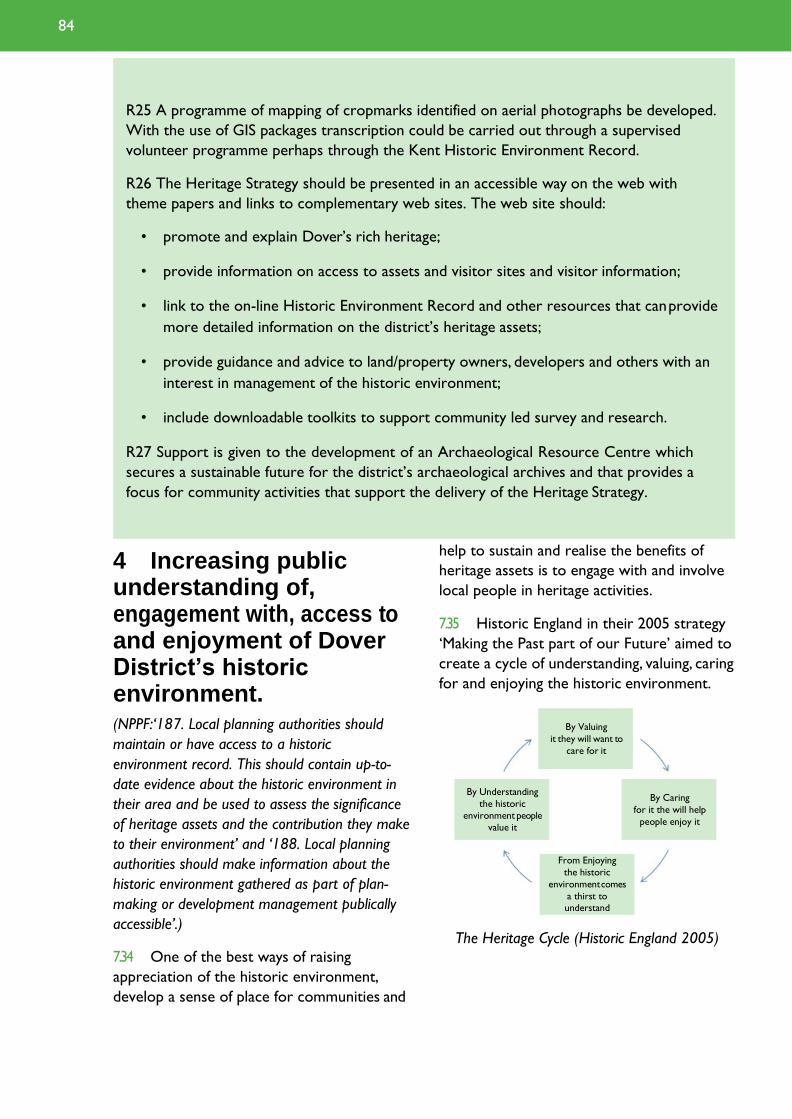
R25 A programme of mapping of cropmarks identified on aerial photographs be developed.
With the use of GIS packages transcription could be carried out through a supervised
volunteer programme perhaps through the Kent Historic Environment Record.
R26 The Heritage Strategy should be presented in an accessible way on the web with
theme papers and links to complementary web sites. The web site should:
• promote and explain Dover’s rich heritage;
• provide information on access to assets and visitor sites and visitor information;
• link to the on-line Historic Environment Record and other resources that can provide
more detailed information on the district’s heritage assets;
• provide guidance and advice to land/property owners, developers and others with an
interest in management of the historic environment;
• include downloadable toolkits to support community led survey and research.
R27 Support is given to the development of an Archaeological Resource Centre which
secures a sustainable future for the district’s archaeological archives and that provides a
focus for community activities that support the delivery of the Heritage Strategy.
4 Increasing public understanding of, engagement with, access to and enjoyment of Dover District’s historic environment. (NPPF:‘187. Local planning authorities should
maintain or have access to a historic
environment record. This should contain up-to-
date evidence about the historic environment in
their area and be used to assess the significance
of heritage assets and the contribution they make
to their environment’ and ‘188. Local planning
authorities should make information about the
historic environment gathered as part of plan-
making or development management publically
accessible’.)
7.34 One of the best ways of raising
appreciation of the historic environment,
develop a sense of place for communities and
help to sustain and realise the benefits of
heritage assets is to engage with and involve
local people in heritage activities.
7.35 Historic England in their 2005 strategy
‘Making the Past part of our Future’ aimed to
create a cycle of understanding, valuing, caring
for and enjoying the historic environment.
The Heritage Cycle (Historic England 2005)
From Enjoying
the historic
environment comes
a thirst to
understand
By Caring
for it the will help
people enjoy it
By Understanding
the historic
environment people
value it
By Valuing
it they will want to
care for it
84

7.36 The Heritage Strategy has identified a
number of areas where further study and
survey would be a benefit, not only identifying
and understanding the heritage assets and
assisting in management of the historic
environment but also in many cases as a
means of engaging with the community.
There are a wide range of activities in which
local communities, interest and other groups
and individuals can become involved with
their heritage. This might be through survey,
research, investigation, assessment and
monitoring of the condition of assets or by
helping with interpretation and management
of the assets. Stakeholder consultation for the
Heritage Strategy specifically highlighted the
potential and desire for local people to
become involved with their heritage and lead
on delivering many aspects of the Heritage
Strategy. Some of the key proposals are
identified in the recommendation (R28) while
others are set out in the individual theme
papers.
7.37 Paragraph 188 of the NPPF identifies
that local planning authorities should make
information about the historic environment
available to the public. Landowners,
developers and other stakeholders with an
interest in the heritage assets of the district
all require accessible information on the
assets to be able to manage their proposals
and ensure that the significance of heritage
assets is sustained and opportunities for
beneficial use are recognised and taken.
7.38 The Kent Historic Environment Record
should remain as the main repository and
source of information concerning the
district’s historic environment; however
programmes to enhance its information
should be developed. In particular the
Strategy has identified the need for an Urban
Archaeological Database for the town and
port of Dover to assist developers and the
local authority to understand the potential
impacts of development on complex
archaeological deposits there. In addition the
6. Historic properties in Deal.
6
85 Dover District Heritage Strategy

Strategy has also identified the potential for a
programme of mapping of cropmarks on
aerial photographs to better understand the
district’s ancient rural landscapes and identify
significant archaeological assets that may be
vulnerable to agriculture and help target
management regimes.
7.39 The Wantsum Sea Channel is a
landscape of considerable historic significance
that links communities bordering the district
and those of Canterbury and Thanet. It has
considerable potential for development as a
rural visitor asset that links to key themes
within the strategy and in particular the
Roman gateway site at Richborough.
Research in the Lydden Valley, which
complements the Wantsum Channel has
demonstrated the potential for community
led research and survey to identify the
history of the area and its assets and the
potential for further research.
7.40 The local authorities can provide a key
role in sustaining community engagement
activities within the historic environment
through leadership and providing a stimulus
for activities, a source of advice and support
and access to information. While there are
considerable limitations in the resources that
the local authorities can provide to engage in
these activities, there may be opportunities
for grant funding that can help to develop
suitable initiatives.
7.41 Increasing use of new technologies and
media provide considerable opportunities for
improving access to information about the
district’s history and its heritage assets
together with visitor information. Work on
the Heritage Strategy has identified that
there are a significant number of web sites
with varying quality of information on the
heritage assets of the district.
7.42 Archaeological work in the district has
resulted in a wealth of records and artefacts
that provide both the evidence base for our
detailed understanding of the history of the
district and an opportunity as a resource for
exhibition, presentation, education and
community activities. The archaeological
archive is presently vulnerable to limited
storage capacity and lack of accessibility. A
long term solution to the appropriate and
accessible storage of archaeological archives
is being sought through the creation of an
archaeological resource centre. Paragraph
199 of the NPPF advises that local planning
authorities should require developers to
make evidence gathered as part of plan-
making or development including any archive
generated publically accessible through the
Historic Environment Record and a local
museum or public depository.
7.43 The district’s heritage themes provide
opportunities for engagement with schools
and adult learning, providing a local context
for the curriculum and an accessible
alternative to increasingly expensive trips
further afield. Visits by students to local sites
and focusing on local heritage assets in their
project work should help to develop an
appreciation for local heritage amongst the
district’s pupils and students and encourage
them to visit the heritage with their families.
7.44 The recommendations set out below all
relate to increasing public understanding of,
engagement with, access to and enjoyment of
the district’s historic environment.
7. Heritage Trails and Information Boards.
7
86
Objective 4 Recommendations
R9 Systems should be put in place to ensure that historic environment information and
advice is readily accessible to local communities to help them shape the places in which
they live.
R10 A programme of Conservation Area appraisal is put in place to cover all the District’s
Conservation Areas. Consideration should be given to developing tool kits for initial
appraisal, at least, to be undertaken by local volunteer groups and individuals. Toolkits
based upon the overview methodology and/or those developed by Historic England could
form the basis for use in the district.
Conservation Area appraisals should be used to review the special interest of each
Conservation Area and inform proposals for any special measures needed, adjustment of
boundaries and, where the significance has been sufficiently lost, removal of Conservation
Area status.
Consider widening the use of Article 4 (1) directives to sustain and enhance the historic
character of the District’s Conservation Areas through ensuring that special interest is
conserved.
Develop guidance and make information easily accessible to enable stakeholders within
Conservation Areas to readily understand and take account of the special interest of the
area and ensure that proposals for change take account of that interest. An example of
appropriate guidance is the treatment of shop fronts in Conservation Areas.
R14 A Local List of Heritage Assets should be developed by Dover District with the
assistance of the voluntary sector. Clear and robust criteria for selection of heritage assets
for inclusion on the List should be set out, together with a requirement to provide for each
asset a statement of significance, condition, vulnerability and potential opportunity for
sustainable use.
The Local List should embrace all elements of the historic environment and it is
recommended that many of the key assets identified in each of the theme papers could
provide a useful starting point for compilation of a Local List for the district. Gardens
identified within the Kent Gardens Compendium and any enhancement of the Compendium
should be included in the Local List.
R15 Dover District Council, with the assistance of the voluntary sector, should develop a
Register of Heritage Assets at Risk.
R16 A Heritage Crime Risk Assessment should be undertaken for Dover District and a
network of volunteer Heritage Wardens established.
R22 Opportunities should be sought to integrate the district’s heritage assets into
curriculum activities for local schools, colleges and life-long learning centres.
R23 Opportunities should be sought and support given to local communities, groups and
individuals in researching their past, develop projects with them that identify, enhance
87 Dover District Heritage Strategy

understanding of the district’s heritage assets and involve them in condition assessment,
monitoring, management, promotion and interpretation of the assets.
Key activities identified for public involvement in delivery of the heritage strategy that have
been identified within the thematic studies include:
• Conservation Area overviews / appraisal and monitoring
• Heritage at Risk Surveys
• Development of Local List of Heritage Assets
• Heritage Wardens
• Parish / Neighbourhood surveys that support neighbourhood plans
• Thematic surveys, research and investigation
• A programme of research, survey and enhanced interpretation of the heritage assets
of the Wantsum Channel and Lydden Valley
• A study of the assets and development of the historic port of Deal
• Identification and research for new themes for the Heritage Strategy
R25 A programme of mapping of cropmarks identified on aerial photographs be developed.
With the use of GIS packages transcription could be carried out through a supervised
volunteer programme perhaps through the Kent Historic Environment Record.
R26 The Heritage Strategy should be presented in an accessible way on the web with
theme papers and links to complementary web sites. The web site should:
• promote and explain Dover’s rich heritage;
• provide information on access to assets and visitor sites and visitor information;
• link to the on-line Historic Environment Record and other resources that can provide
more detailed information on the district’s heritage assets;
• provide guidance and advice to land/property owners, developers and others with an
interest in management of the historic environment;
• include downloadable toolkits to support community led survey and research.
R27 Support is given to the development of an Archaeological Resource Centre which
secures a sustainable future for the district’s archaeological archives and that provides a
focus for community activities that support the delivery of the Heritage Strategy.
88

Taking the Heritage Strategy Forward 7.45 The Heritage Strategy in its present
form provides a sound and enhanced
evidence base which can be used for future
decision making in Dover District. It provides
a snapshot of the district’s heritage taken at
this point in time, however it should be seen
as a living document that can be regularly
monitored, reviewed and updated in response
to new findings, challenges and priorities.
7.46 As a result of the work carried out for
the Heritage Strategy a considerable number
of recommendations have been identified
ranging from those that require policy
support down to more specific local or asset
specific actions. The main recommendations
arising from the study (R1 to R27) are set
out in the table at the end of this chapter
with reference back to the four objectives for
taking the strategy forward and an indication
as to the area of potential stakeholder
interest for each.
7.47 The next stage for the Heritage
Strategy should be to develop a Heritage
Action Plan based around the key
recommendations set out above and the
numerous other recommendations found
elsewhere in the Strategy. This detailed
Action Plan should identify:
• key priorities that have emerged from
the Heritage Strategy and the public
consultation;
• who the key stakeholders are and their
role in ownership of and helping to
deliver the Heritage Strategy; in
particular the role of the District
Council and that of the voluntary
sector needs to be clearly set out;
• a programme for carrying out the
Action Plan that details how it will be
monitored, reviewed and its success
measured;
8. Dover Castle.
• sources and opportunities for funding
and obtaining the resources needed to
deliver the Heritage Strategy.
Establishing Priorities
7.48 The Heritage Strategy has identified a
considerable number of potential actions, at
varying scales and levels of importance. It
would be unrealistic to expect that all of
these can be achieved in the short term life
though some progress could be achieved on
many. The Action Plan will need to identify
the main priorities that should be focused on
in the short term. The priorities should be
selected on the basis of the extent to which
they address the Heritage Strategy’s four
core objectives and where there is immediate
need in response to proposals for change and
significant risk to heritage assets. There are
clear contenders for priority action:
• Conservation, appropriate development
and promotion of the Dover Western
Heights, a major heritage asset at
considerable risk that could play a
significant role in Dover’s regeneration:
8
89 Dover District Heritage Strategy
• Ensure that the historic environment is
taken fully into account in proposals for
regeneration and in particular the
strategic allocation sites in the Local
Plan.
• Maximising the economic benefit of
visitors to Dover Castle by improving
links with the town centre and
encouraging more overnight visits to
the district through promoting the
Castle as part of a package of
attractions;
• Improve the capacity to manage the
conservation of heritage assets through
establishing a Local List, local Heritage
at Risk Register and Conservation Area
Appraisals.
• Ensuring that communities can easily
access information and guidance on
their historic environment and that they
are provided with opportunities to
engage with their heritage and use it to
shape the places in which they live and
work, particularly through
neighbourhood planning.
7.49 As well as the more important
priorities that operate at a district level it is
important that those at a more local level are
also supported as these are likely to have a
particular relevance to those local
communities, be more easily delivered and
help to engage and build support for the
larger initiatives.
Stakeholders and ownership of delivery
7.50 At a time of increasing pressure on
local authority funding and resources creative
solutions need to be sought to take the
Heritage Strategy forward. The Strategy has
identified the considerable role that district’s
communities and voluntary sector can play in
helping to deliver many of the aspects of the
strategy. The role of the local authorities and
their heritage professionals and advisors,
town and parish councils wherever possible
should be one of acting as a focus, facilitating,
coordination and providing advice,
information and support to the community
to deliver the desired outcomes. The Dover
District Heritage Strategy has the potential
to deliver gains and benefits that would not
otherwise be realised solely through public
funding.
7.51 This will, however, mean a change in the
Local Authority’s role. In the past this has
been more reactive rather than proactive,
due to limited and diminishing staff resources.
In order to achieve this, the role of the Local
Authority will have to evolve to become a
facilitator and the District Council will need
to change the working practices to account
for this. This would then enable the district’s
important heritage assets to be appropriately
managed and to ensure that they contribute
to the regeneration of the district within the
existing financial and staff resources.
7.52 The creation of a district-wide historic
environment forum may help to take the
Strategy forward. Such a Forum could
perhaps take a lead in implementing and
monitoring the Strategy, may be able to link
into funding streams that the District Council
is unable to and provide a wider sense of
ownership of the Strategy. The District
Council’s Heritage Champion should play a
significant role in linking such a forum with
the District Council and ensuring that a
common purpose is worked towards. The
forum should include key representatives
from each of the sectors with an interest in
the Strategy: planning and development; land
and property owners, the voluntary sector,
tourism, education and the community as
well as the district’s main heritage
professionals and bodies.
90

Programming, monitoring and review
7.53 The evidence base set out in the
Heritage Strategy is a snapshot of the
district’s heritage at this moment at time
and has its limitations. The evidence base
will constantly evolve in light of new
research and discoveries, consideration of
new themes and as new challenges and
opportunities emerge. The Strategy should
therefore be considered as a dynamic
document that can be updated as it goes
along. It is anticipated that the Heritage
Strategy will be formally reviewed in parallel
with the Local Plan however it should be
monitored on an annual basis and adjusted
where possible to take account of changing
evidence and circumstances.
7.54 The Action Plan should set out a
timetable for delivery of its priority actions
as far as it is able to and how the actions
will be monitored.
7.55 Criteria should be developed against which can be used
to measure the success of the heritage strategy. The
criteria should be clearly set out in the Action Plan and
should be readily quantifiable. Examples could include the
number of heritage assets that have been removed from
national and local ‘at risk’ registers, conservation area
appraisals carried out, review of visitor numbers at
heritage attractions, volunteer numbers in delivering
strategy actions, heritage assets re- used in regeneration
projects etc.
Funding and resources
7.56 At a time of diminishing public sector funding and
increased pressure on available resources, the role of
the voluntary sector in delivering the Heritage Strategy
can not be understated. Many of the actions that will
emerge from the Heritage Strategy can at least in part
be addressed by or with the help of the voluntary
sector. As stated above the Council’s role should be that
of facilitating and helping to co-ordinate the delivery of
the strategy or through use of its statutory functions
ensuring that those proposing change take appropriate
account of the historic environment in accordance with
the district’s objectives.
7.57 Regardless there will inevitably be funding
requirements and in particular it is recommended that
funding is sought to engage an officer responsible for the
development and co-ordination of the Action Plan.
Without a dedicated officer it may be difficult to build
up the momentum that would ensure engagement by
the voluntary sector.
7.58 There are sources of funding which may be
considered for delivery of the Strategy’s objectives:
• The National Lottery Heritage Fund objectives of
helping people to learn about their heritage, take an
active role in and make decisions about heritage and to
9. The Old Canonry & Dog Inn, Wingham.
9
91 Dover District Heritage Strategy

conserve the heritage for present and future
generations to experience and enjoy align
with many of the activities the strategy seeks
to deliver. The NLHF supports a number of
grant programmes ranging from smaller
grants of a few thousand to those in excess
of a hundred thousand pounds.
• Planning obligations and gains, and
funding made available through the
Community Infrastructure Levy may
help to achieve positive outcomes for
the historic environment and the
delivery of the Strategy’s objectives.
• Other grant funding opportunities
should be sought to integrate the
objectives and actions of the Strategy
into wider projects, for example the
European Straits Initiative which
includes the Strait of Dover and
promotes joint activities that include
tourism, culture, environment,
economic development and improved
public services.
• Working in partnership to secure
regeneration funding, assistance from
heritage funding bodies and the private
sector.
10. Second World War pillbox, St Margaret's Bay.
11. Eastry Court.
12. Dover Harbour
10 11
92
12

Reccomendation Objective Stakeholder
R1 The historic environment should be embraced as an
1
1
1
1
1
1
1
PD, C
PD
PD
PD
PD
PD
PD
important element in proposals for regeneration and new development to help develop a strong ‘sense of place’ and an identity for existing and new communities. Particular attention should be given to key gateways and routes to and through the district's towns and rural settlements.
R2 The character and form of existing heritage assets should be used to help shape the character and form of new development. The historic environment should be considered and reflected in development
master plans.
R3 The sustainable and beneficial reuse of heritage assets, conserving them in a manner appropriate to their significance, should be encouraged in new development and given appropriate weight in making planning decisions.
R4 Proposals for new development should include an appropriate description of the significance of any heritage assets that may be affected including the contribution of their setting. The impact of the development proposals on the significance of the heritage assets should be sufficiently assessed using appropriate expertise where necessary. Desk-based assessment, archaeological field evaluation and historic building assessment may be required as appropriate to the case.
R5 Use of materials should be encouraged in new development that helps to make it more sustainable and foster local distinctiveness.
R6 The opportunities that the historic environment and heritage assets present and their vulnerability to change should be taken into account in considering development allocations.
R7 Improved guidance for compiling and the required content of Heritage Statements should be developed and made available to planning applicants. The methodology developed for checking proposals against the Heritage Strategy themes should be developed for use in Heritage Statements.
Key for Stakeholder column: PD – Planning & Development; LP – Land & Property Ownership; VS – Voluntary Sector; T – Tourism; ED – Education; C – Community
93 Dover District Heritage Strategy

Reccomendation Objective Stakeholder
R8 The recommendations and guiding principles set out
in the case studies for Discovery Park, North Deal,
1
PD
Fort Burgoyne & Connaught
Barracks are followed.
R9 Systems should be put in place to ensure that
historic environment information and advice is readily 1, 4 PD, C
accessible to local communities to help them shape
the places in which they live.
R10 A programme of Conservation Area appraisal is put
in place to cover all the District’s Conservation Areas. 1, 3, 4 PD, LP,VS, C
Consideration should be given to developing tool kits
for initial appraisal, at least, to be undertaken by local
volunteer groups and individuals. Toolkits based upon
the overview methodology and/or those developed
by Historic England could form the basis for use in
the district.
Conservation Area appraisals should be used to
review the special interest of each Conservation
Area and inform proposals for any special measures
needed, adjustment of boundaries and, where the
significance has been sufficiently lost, removal of
Conservation Area status.
Consider widening the use of Article 4 (1) directives
to sustain and enhance the historic character of the
District’s Conservation Areas through ensuring that
special interest is conserved.
Develop guidance and make information easily
accessible to enable stakeholders within
Conservation Areas to readily understand and take
account of the special interest of the area and ensure
that proposals for change take account of that
interest. An example of appropriate guidance is the
treatment of shop fronts in Conservation Areas.
R11 Consider the potential for new Conservation Areas
at Snargate Street, Dover and Kearsney Abbey taking 3 PD, LP, C
account of paragraph 127 of the NPPF.
R12 In liaison with Historic England review and
identify gaps in designation of heritage assets and
in particular consider those key sites identified
3 PD, LP
as potential candidates in the Heritage Strategy
thematic papers.
94

Reccomendation Objective Stakeholder
R13 Work towards the conservation, appropriate
development and promotion of the Dover Western
1, 2, 3
PD, LP,T
Heights so that it might contribute to the
regeneration of Dover. Establish an agreed vision, to
inform a master plan and promote appropriate
development and change that is consistent with the
conservation and enhancement of the Dover
Western Heights’ significance.
R14 A Local List of Heritage Assets should be developed
by Dover District with the assistance of the voluntary 3, 4 PD, LP,VS, C
sector. Clear and robust criteria for selection of
heritage assets for inclusion on the List should be set
out, together with a requirement to provide for each
asset a statement of significance, condition,
vulnerability and potential opportunity for sustainable
use.
The Local List should embrace all elements of the
historic environment and it is recommended that
many of the key assets identified in each of the
theme papers could provide a useful starting point
for compilation of a Local List for the district.
Gardens identified within the Kent Gardens
Compendium and any enhancement of the
Compendium should be included in the Local List.
R15 Dover District Council, with the assistance of the
voluntary sector, should develop a Register of 3, 4 PD, LP,VS, C
Heritage Assets at Risk.
R16 A Heritage Crime Risk Assessment should be
undertaken for Dover District and a network of 3, 4 PD, LP,VS, C
volunteer Heritage Wardens established.
R17 Maximise the benefit to the district's economy of
visitors to Dover Castle through developing better 2 PD, LP,T, C
links with the town centre; Promote as part of a
wider package with other heritage assets to
encourage more overnight stays in the area.
R18 The district’s wider heritage potential and heritage
assets should be promoted alongside the key assets 2 LP,T, C
as part of a broad and diverse offer to encourage
more overnight stays in the district. The
charitable museums is integral to the promotion of
the district's heritage.
Key for Stakeholder column: PD – Planning & Development; LP – Land & Property Ownership; VS – Voluntary Sector; T – Tourism; ED – Education; C – Community
95 Dover District Heritage Strategy

Reccomendation Objective Stakeholder
R19 The current tourism sites, public heritage 2 LP,T, C interpretation and trails should be mapped and
assessed to identify opportunities for networking,
promotion and investment in improved facilities and
interpretation.
R20 Opportunities should be sought to develop access to 2 PD, PL, ED,T, C key heritage sites and improve interpretation for
visitors.
R21 Access and interpretation should be developed to 2 PD, ED,T link heritage assets by theme making use of the
incredible rich history of the district referenced in
the Theme papers of the Heritage Strategy.
R22 Opportunities should be sought to integrate the 4 ED District’s heritage assets into curriculum activities for
local schools, colleges and life-long learning centres.
R23 Opportunities should be sought and support given 2,4 PD, LP,VS, ED,T, C to local communities, groups and individuals in
researching their past, develop projects with them
that identify, enhance understanding of the district’s
heritage assets and involve them in condition
assessment, monitoring, management, promotion and
interpretation of the assets.
Key activities identified for public involvement in
delivery of the heritage strategy that have been
identified within the thematic studies include:
• Conservation Area overviews / appraisal and
monitoring
• Heritage at Risk Surveys
• Development of Local List of Heritage Assets
• Heritage Wardens
• Parish / Neighbourhood surveys that support
neighbourhood plans
• Thematic surveys, research and investigation
• A programme of research, survey and
enhanced interpretation of the heritage assets
of the Wantsum Channel and Lydden Valley
• A study of the assets and development of the
historic port of Deal
• Identification and research for new themes for
the Heritage Strategy
96

Reccomendation Objective Stakeholder
R24 An Urban Archaeological Database be prepared for
Dover town preferably extended to include a wider
range of heritage assets of the town, port and the
flanking heights and Dour valley.
1, 3
PD, LP
R25 A programme of mapping of cropmarks identified on
aerial photographs be developed. With the use of
GIS packages transcription could be carried out
through a supervised volunteer programme perhaps
through the Kent Historic Environment Record.
1, 3, 4 PD, LP,VS
R26 The Heritage Strategy should be presented in an
accessible way on the web with theme papers and
links to complementary web sites. The web site
should:
1, 2, 3, 4 PD, LP,VS, ED,T, C
• promote and explain Dover’s rich heritage;
• provide information on access to assets and
visitor sites and visitor information;
• link to the on-line Historic Environment
Record and other resources that can provide
more detailed information on the district’s
heritage assets;
• provide guidance and advice to land/property
owners, developers and others with an interest
in management of the historic environment;
• include downloadable toolkits to support
community led survey and research.
R27 Support is given to the development of an
Archaeological Resource Centre which secures a
sustainable future for the district’s archaeological
archives and that provides a focus for community
activities that support the delivery of the Heritage
Strategy.
1, 3, 4 PD, LP,VS, ED,T, C
Key for Stakeholder column: PD – Planning & Development; LP – Land & Property Ownership; VS – Voluntary Sector; T – Tourism; ED – Education; C – Community
97 Dover District Heritage Strategy

8 Sources & Consultation

Sources and Consultation Acknowledgements and authorship
8.1 The Dover District Heritage Strategy
was compiled by the Heritage Conservation
Group at Kent County Council on behalf of
Dover District Council and English Heritage
(now Historic England). Principal authors
were Ben Found and Simon Mason with
significant contributions from Allan Cox, Paul
Cuming and Tanya Szendeffy. Figures were
prepared by Matt Butler, Ben Croxford and
Paul Cuming. A Steering Group comprising
Allan Cox, Lis Dyson, Ben Found and Simon
Mason (Kent County Council), Clive
Alexander, Mike Ebbs, Jon Iveson and David
Whittington (Dover District Council) and
Andy Brown and Peter Kendall (English
Heritage) oversaw the production of the
strategy. Various other individuals, groups
and organisations kindly provided advice and
information during the production of the
Heritage Strategy and in particular Keith
Parfitt and Andrew Richardson of the
Policy National Planning Policy Framework:
Canterbury Archaeological Trust.We would like to additionally thank all those who provided photographs
for the Strategy and in particular Dover Museum,
Canterbury Archaeological Trust and Explore Kent for
access to their extensive collections.The Strategy was
also informed by valuable feedback arising from two
Stakeholder events held in Dover on the 15th
December 2011 and the 10th July 2012.
Sources and information
8.2 A wide range of guidance and source
material has been consulted during the
production of the Dover District Heritage
Strategy.These have included both printed
and web-based material as well as local
knowledge and expertise. A list of sources
and useful information is provided at the end
of each of the Theme Papers in Appendix 1.
8.3 During the production of the Dover
District Heritage Strategy a number of key
sources of information and guidance were
identified which should be used to guide and
inform any future development or
regeneration proposals in the district. An
updated list of current sources and guidance
is provided below:
http://www.communities.gov.uk/documents/planningandbuilding/pdf/2116950.pdf
Historic Environment Information
Kent Historic Environment Record: http://www.kent.gov.uk/HER
The National Heritage List for England: http://historicengland.org.uk/listing/the-list/
Heritage Gateway: http://www.heritagegateway.org.uk/gateway/
Conservation Areas – Dover District Council
http://www.dover.gov.uk/conservation/conservation_areas.aspx
Listed Buildings – Dover District Council: http://www.dover.gov.uk/conservation/listed_buildings.aspx
Heritage at Risk – Historic England: http://historicengland.org.uk/advice/heritage-at-risk/
99 Dover District Heritage Strategy

Guidance & Principles The Historic Environment in Local Plans: Historic Environment Good Practice Advice in Planning:
1 – Historic England
https://historicengland.org.uk/images-books/publications/gpa1-historic-environment-local-
plans/gpa1/
Managing Significance in Decision-Taking in the Historic Environment: Historic Environment Good
Practice Advice in Planning 2- Historic England https://historicengland.org.uk/images-
books/publications/gpa2-managing-significance-in-decision-taking/gpa2/
The Setting of Heritage Assets: Historic Environment Good Practice Advice in Planning Note 3
(Second Edition) – Historic England https://historicengland.org.uk/images-books/publications/gpa3-
setting-of-heritage-assets/heag180-gpa3-setting-heritage-assets/
Conservation Principles, Policies and Guidance – Historic England
http://historicengland.org.uk/advice/cinstructive-conservation/conservation-principles/
National Heritage Protection Plan – Historic England
http://historicengland.org.uk/images-books/publications/nhpp-plan-framework/
Heritage Counts – Historic England: https://historicengland.org.uk/research/heritage-counts/
National Lottery Heritage: https://www.heritagefund.org.uk/
Good Practice Guide for Local Heritage Listing – Historic England
https://historicengland.org.uk/images-books/publications/local-heritage-listing-advice-note-
7/heag018-local-heritage-listing/
Understanding Historic Place: Historic Area Assessments, Principles and Practice – Historic England https://historicengland.org.uk/images-books/publications/understanding-place-historic-
area-assessments/heag146-understanding-place-haa/
Heritage Works: A toolkit of best practice in heritage regeneration– RICS, BPF & Historic England
https://www.bpf.org.uk/sites/default/files/resources/Heritage-Works-14July2017-for-web.pdf
Rural planning- Historic England advice: https://historicengland.org.uk/advice/planning/rural-
planning/
Neighbourhood planning and the historic environment:
https://historicengland.org.uk/advice/planning/improve-your-neighbourhood/
Archaeology and Development: a good practice guide to managing risk and maximising benefit –
CIRIA
https://www.ciria.org/ItemDetail?iProductCode=C672&Category=BOOK&WebsiteKey=3f18c87a-
d62b-4eca-8ef4-9b09309c1c91
Historic England- seaside resorts
https://historicengland.org.uk/research/current/discover-and-understand/coastal-and-
marine/seaside-resorts/
111 100

Coastal Regeneration in English Resorts 2010- Coastal Communities Alliance
https://www.coastalcommunities.co.uk/wp-content/uploads/2015/07/coastal-regeneration-
handbook.pdf
Vacant Historic Buildings: An owner’s guide to temporary uses, maintenance and mothballing –
Historic England https://historicengland.org.uk/images-
books/publications/vacanthistoricbuildings/heag183-vacant-historic-buildings/
Understanding Historic Buildings: A guide to good recording practice – Historic England
https://historicengland.org.uk/images-books/publications/understanding-historic-buildings/heag099-understanding-historic-buildings/
Heritage, Climate Change and Environment – Historic England
https://historicengland.org.uk/research/current/threats/heritage-climate-change-environment/
Wind Energy – Historic England
https://historicengland.org.uk/advice/planning/infrastructure/renewable-energy/wind-energy/
Streets for All: South East – Historic England 2018
https://historicengland.org.uk/images-books/publications/streets-for-all-south-east/heag149f-sfa-
south-east/
Kent Downs AONB Farmstead Guidance – Kent County Council, Historic England & Kent Downs
AoNB https://shareweb.kent.gov.uk/Documents/community-and-
living/Regeneration/Kent%20Downs%20AONB%20Farmsteads%20Guidance.pdf
Protected Rural Landscapes – Historic England https://historicengland.org.uk/advice/caring-for-
heritage/rural-heritage/protected-rural-landscapes/
Best Practice Case Studies
Valuing Places: Good Practice in Conservation Areas – Historic England
https://historicengland.org.uk/images-books/publications/valuing-places/valuing-places-good-
practice-conservation-areas/
Values and Benefits of heritage: a research review – The Heritage Lottery Fund 2016
https://www.heritagefund.org.uk/sites/default/files/media/research/values_and_benefits_of_heritage
_2015.pdf
Shared Interest: Celebrating Investment in the Historic Environment – Historic England
https://historicengland.org.uk/images-books/publications/shared-interest/shared_interest/
Historic Town Centres and High Streets – Historic England
https://historicengland.org.uk/advice/planning/historic-towns-and-high-streets/
Discovery, Innovation and Science in the Historic Environment: Issue 13 Tourism and Seaside
Special - Historic England https://historicengland.org.uk/images-books/publications/historic-england-
research-13/he-research-13/
Resources to Support Place-Making and Regeneration- Historic England
https://historicengland.org.uk/advice/planning/place-making-and-regeneration/
101
