docs.azgs.az.govdocs.azgs.az.gov/onlineaccessminefiles/s-z/whitemesa...(presented in 1993) boonville...
TRANSCRIPT
The following file is part of the
Arizona Department of Mines and Mineral Resources Mining Collection
ACCESS STATEMENT
These digitized collections are accessible for purposes of education and research. We have indicated what we know about copyright and rights of privacy, publicity, or trademark. Due to the nature of archival collections, we are not always able to identify this information. We are eager to hear from any rights owners, so that we may obtain accurate information. Upon request, we will remove material from public view while we address a rights issue.
CONSTRAINTS STATEMENT
The Arizona Geological Survey does not claim to control all rights for all materials in its collection. These rights include, but are not limited to: copyright, privacy rights, and cultural protection rights. The User hereby assumes all responsibility for obtaining any rights to use the material in excess of “fair use.”
The Survey makes no intellectual property claims to the products created by individual authors in the manuscript collections, except when the author deeded those rights to the Survey or when those authors were employed by the State of Arizona and created intellectual products as a function of their official duties. The Survey does maintain property rights to the physical and digital representations of the works.
QUALITY STATEMENT
The Arizona Geological Survey is not responsible for the accuracy of the records, information, or opinions that may be contained in the files. The Survey collects, catalogs, and archives data on mineral properties regardless of its views of the veracity or accuracy of those data.
CONTACT INFORMATION Mining Records Curator
Arizona Geological Survey 1520 West Adams St.
Phoenix, AZ 85007 602-771-1601
http://www.azgs.az.gov [email protected]

ABANDONED MINE LAND RECLA,j\ilA TION AWARD WINN,ERS
Land Reclamation
: Home Page Directory Index Search Ask a question Help
------ --- ---
1992 Awards (Presented in 1993)
Boonville Hospital RAMP Project, Indiana Coppermine Abandoned Mine Project, Navajo Reservation Gay Branch Gob Pile Project, Virginia Lead and Zinc Mine Sites Reclamation Project, Illinois Ocean Refuse Removal Project, Maryland Pine Creek Mine Shafts Project, West Virginia Pyramid Coal Company Reclamation Project, Illinois Shiloh Reclamation Project, Arkansas Veca Pit and Spoils Project, Wyoming White Oak Four Reclamation Project, Ohio
--- ._--_ .. _-_ .. _ ------_._----_._._--_.-
2000 Awards
Regional Awards
Pleasant View Mine Project, Kentucky (Appalachian Region) Midwestern Reclamation Project, Indiana (Mid-Continent Region)
-Ii Carrizo 1 Reclamation Project, Navajo Reservation, Arizona and New Mexico (Western Region)
National Award
Pleasant View Mine Project, Kentucky
People's Choice Award
Midwestern Reclamation Project, Indiana
1999 Awards
Regional Awards
Blackwater River Limestone Drum Station, West Virginia (Appalachian Region)
Page 10f3
Oklahoma Partnership Approach to Reclamation of Abandoned Mine Land, Oklahoma (Mid-Continent Region) Socorro West, New Mexico (Western Region)
National Award
~ Monument Valley 2 AML Reclamation Project, Navajo Reservation
http ://www.osmre.gov/awardwin2.htm 04116/2002
j
) .. '
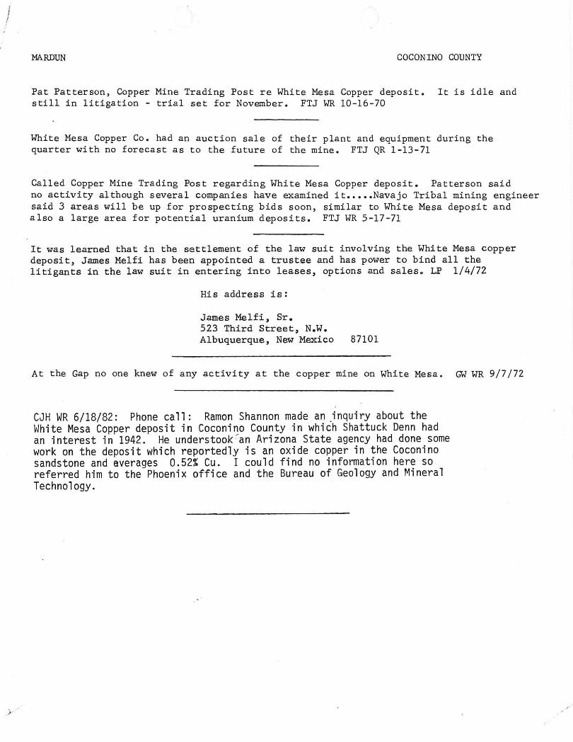
MARDUN COCONINO COUNTY
Pat Patterson, Copper Mine Trading Post re White Mesa Copper deposit. It is idle and still in litigation - trial set for November. FTJ WR 10-16-70
White Mesa Copper Co. had an auction sale of their plant and equipment during the quarter with no forecast as to the future of the mine. FTJ QR 1-13-71
Called Copper Mine Trading Post regarding White Mesa Copper deposit. Patterson said no activity although several companies have examined it ••••• Navajo Tribal mining engineer said 3 areas will be up for prospecting bids soon, similar to White Mesa deposit and also a large area for potential uranium deposits. FTJ WR 5-17-71
It was learned that in the settlement of the law suit involving the White Mesa copper deposit, James Melfi has been appointed a trustee and has power to bind all the litigants in the law suit in entering into leases, options and sales o LP 1/4/72
His address is:
James Melfi, Sr. 523 Third Street, N.W. Albuquerque, New Mexico 87101
At the Gap no one knew of any activity at the copper mine on White Mesa. GW WR 9/7/72
CJH WR 6/18/82: Phone call: Ramon Shannon made an "inquiry about the White Mesa Copper deposit in Coconino County in which Shattuck Denn had an interest in 1942. He understook :"an Arizona State agency had done some work on the deposit which reportedly is an oxide copper in the Coconino sandstone and averages 0.52% Cu. I could find no information here so referred him to the Phoenix office and the Bureau of Geology and Mineral Technology.
MARDUN
Visited White Mesa Co., Inc. - Mardun mine. it leak proof. No mining being done. Other operation in a month or six weeks. Chas. S. FTJ WR 5-12-67
COCON INa COUNTY
4 men working settling pond trying to make w;rk is planned and hopes are to begin (Bill) Tornbom is the new supt.
The White Mesa Co., Inc. has been operating two months, but have been having difficulty with slimes. Memo to follow. Went to examine pit and outcrop one-half mile southwest of present pit. FTJ WR 9-15-67
Active Mine List Nov. 1967 - 25 men
White Mesa Co., Mardun, is expected to have operated during the quarter. FTJ QR 66-67
White Mesa (Mardun) is said to have some operating difficulties but this could not be verified. FTJ QR 4-1967
Mineral Resources, Inc., Box 202, Fargo, North Dakota 58102. Corres. 7-5-67
Active Mine List April 1968 - 25 men
Visited White Mesa Co., Inc. They have not operated since December. Rumored that Aimes was trying to get some financing. For information in the future we can call General Communications in Flagstaff and ask for Copper Mine Trading Post and Mr. Patterson will have the answers. All the mining equipment, etc., are at the mine. FTJ WR 5-17-68
The copper leaching operation (Mardun) on White Mesa was shut down for the whole of the quarter. FTJ QR 7-1-68
Mine visit to the Mardun mine. Irregular oxide copper is in sandstone. No m~n~ng since Dec. 12, 1967 according to Coit Patterson, owner of Copper Mines Trading Post about 100 yards north of the open pit mine. The leaching plant has been badly treated by vandals. Mr. Patterson said there was a talk of Mr. Shotwell, former producer of pumice from north of Flagstaff for use as pozzolan in concrete for Glen Canyon dam, taking hold of the Mardun. FPK field trip notes 5-6-69
Visited White Mesa. No one at the mine. Company has suits against it, bad debts, etc. FTJ WR 9-12 -69
A Mr. Aimes of Minnesota, brother of Aimes of White Mesa, was loading a large gyratory crusher on a truck for transport to Minnesota. He said his brother is trying to straighten out the affair on White Mesa. (Mardun) FTJ WR 5-15-70
Active Mine List May 1970 - not active

-r i
MARDUN COCININO COUNTY
Active Mine List Oct. 1963 - 22 men working
Visited Zontelli Bros. leaching operation at Copper Mine, Harho Saari, Supt., said they had had quite a little water trouble. At the time of the visit about 200 gpm were going on the dump. EGW WR 5-19-64
Visited Zontelli Bros. Copper Mine. They now have 200-250 gpm going thru the precipitating plant. A new well was started to increase the water supply, but at 350 ft. they lost their drill tools. At the time of the visit another drill rig was being moved in to start another hole. EGW WR 9-15-64
Visited Zontelli Western Plant at Copper mine, interviewed John Simmons and Harho Saari, Supt. They are still having water trouble, only 90 gpm going through the plant. EGW WR 5 -14-65
Visited Zontelli Western - Revere Copper and Brass have dropped their option and Zontelli Western is in the process of reorganizing. 5 men, including supervision, employed leaching small but higher grade material. Water is a continuous problem. FTJ WR 9-17-65
Mardun - Zontelli Bros. - According to C. Kuzell, the sandstone copper ore carries "pitch copper". It is a hydrated copper oxide which looks like obsidian. It has chemically bonded H20. Mineral "has dry look-like flint." FPK 11-22-65
Visited the White Mesa Copper deposit which is now called White Mesa Co., Inc., P.O. Box 1565, Page, Arizona. Donald Aimes of Fargo, North Dakota is president. Harho Saari, Res. Supt. Their flow sheet has been designed by Denver Equipment. Mechanization is to be used as far as possible. Electric power is to be supplied by Arizona Public Service, replacing the diesel plant at the mine. An electric shovel is to be used in the mine, loading into a portable conveyor to the crushing unit. Oie will be crushed to 4 mesh then conveyed to two leach vats which are agitated. From the leach vats the solution and tails go to settling tanks. The tails are fed to a portable stacker and the pregnant solution is fed to vats, using tin cans for preCipitation. Plant will have a capacity of 50 tph producing about 10,000 # of 79% Cu cement. The operation is to be continuous. 18 to 20 men will be employed. All equipment is new and operations are expected to begin sometime in June. Construction now taking place and the mine is being prepared. A short tunnel to the mine from plant to house the conveyor and make the plant accessible from the pit is near completion. FTJ WR 5-14-66
White Mesa Co. operating the Mardun (Zontelli Western) were expected to be in operation by mid-June. FTJ QR 7-8-66
Interview wiili Harho Saari, Res. Mgr., and Mr. Aimes, Pres., Arizona Copper Project Div., of White Mesa Co., Inc. (Mardun Mine). They were trying to start the leach operation that was scheduled to start in July, but held up waiting for power to be delivered by APS who were setting up at the time of visit. Temporary power is being supplied by 2 diesel plants. No mining was being done as there was enough ore broken to make a trial run. FTJ WR 9-16-66

MARDUN COCONINO COUNTY
Visit from Sam Thurmond, supt. for the Zontelli Bros. exploration project in the White Mesa sandstone copper area - Mardun, etc. - consulted our files and maps, and reported he had drilled some 500 to 600 holes and his people were evaluating the results with an expectation that a producing project might be justified. TPL WR 4-28-62
Mr. Collins said Zontelli Bros. have been drilling l~ years and think they may find enough small deposits to make it go. They don't plan a big operation. Believe they can get enough tin cans from the Indians who use a lot of canned soft drinks and beero FPK 8-30-62
Visited Zontelli Broso heap leach at Coppermine in the White Mesa regiono The mine is about halfway between the Gap and Page, 27 miles off Highway 89.
At present they have two stockpileso One about 25,000 tons and one about 50,000. Bulldozers were just starting the third stockpile.
The leaching plant isn't complete just yet so only the small stockpile has solution on it. The pregnant solution goes to the leaching plant thru plastic tubing and thru the completed part of the leaching plant and is then pumped back on the small stockpileo
The water for the plant comes from a well eight miles away. Mr. Thurmond said they have plenty.
So far, plenty of tin cans have been supplied by the Indians.
It is expected the plant will be complete by the first of Mayo EGW Memo 4-17-63
Zontelli Western Co. secured in April a SBA loan for $66,500. 10 men working - copper mining. from - G. Moore - 6-3-63 LP
Zontelli Western Mining has a $66,500 loan from the Small Business Administration to explore and develop a copper mining project in Coconino County. The Zontelli firm bases out of Ironton, Minn., where it has developed iron deposits over the past 2~ years. Two ore stockpiles have been prepared at the Arizona operation - one of 25,000 tons, the other of 50,000. Leaching operations have been started with water supplied from a well eight miles distant. E&MJ August 1963
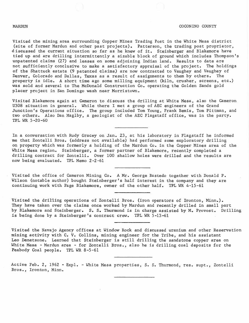
MARDUN COCONINO COUNTY
Visited the m~n~ng area surrounding Copper Mines Trading Post in the White Mesa district (site of former Mardun and other past projects). Patterson, the trading post proprietor,
discussed the current situation so far as he knew of it. Steinberger and Blakemore have tied up and are drilling intermittently a sizable block of ground which includes Thompson's unpatented claims (27) and leases on some adjoining Indian land. Results to date are not sufficiently conclusive to make a satisfactory appraisal of the project. The holdings of the Shattuck estate (9 patented claims) are now contracted to Vaughey and Vaughey of Denver, Colorado and Dallas, Texas as a result of assignments to them by others. The property is idle. A short time ago some milling equipment (kiln, crusher, screens, etc.) was sold and several to The McDonald Construction Co. operating the Golden Sands gold placer project in San Domingo wash near Morristown.
Visited Blakemore again at Cameron to discuss the drilling at White Mesa, also the Cameron U308 situation in general. While there I met a group of AEC engineers of the Grand Junction's Operations office. The group included Tom Young, Frank Bemis, Tom Pittman, and two others . Also Dan Maglby, a geologist of the AEC Flagstaff office, was in the party. TPL WR 5-20-60
In a conversation with Rudy Gracey on Jan. 23, at his laboratory in Flagstaff he informed me that Zontelli Bros. (address not available) had performed some exploratory drilling on property which was formerly a holding of the Mardun Co. in the Copper Mines area of the White Mesa region. Steinberger, a former partner of Blakemore, recently completed a drilling contract for Zontelli. Over 100 shallow holes were drilled and the results are now being evaluated. TPL Memo 2-2-61
Visited the office of Cameron Mining Co. A Mr. George Bastedo together with Donald P. Wilson (notable author) bought Steinberger's half interest in the company and they are continuing work with Page Blakemore, owner of the other half. TPL WR 4 -15-61
Visited the dril-ling operations of Zontelli Bros. (iron operators of Ironton, Minn.). They have taken over the claims once worked by Mardun and recently drilled in small part by Blakemore and Steinberger. S. S. Thurmond is in charge assisted by M. Provost. Drilling is being done by a Steinberger's contract crew. TPL WR 5-13-61
Visited the Navajo Agency offices at Window Rock and discussed uranium and other Reservation mining activity with C. V. Collins, mining engineer for the Tribe, and his assistant Leo Denetsone. Learned that Steinberger is still drilling the sandstone copper area on White Mesa - Mardun area - for Zontelli Bros., also he is drilling coal deposits for the Peabody Coal people. TPL WR 8-5-61
Active Feb. 2, 1962 - Expl. - White Mesa properties, S. S. Thurmond, res. supt., Zontelli Bros., Ironton, Minn.

MARDUN COCONINO COUNTY
Visited the Copper mine on White Mesa, 22 miles southerly from Page. The property, formerly operated by the Mardun Co. and more recently by Able Mining Co., was idle. TPL WR 5-20-58
Visited the Copper Mine Trading Post copper area which includes the Claude Thompson claims (28 unpatented) and the Shattuck claims (9 patented) and development on adjoining Indian lands formerly worked by Mardun. There is no present activity on these sandstone copper properties. Mr. Patterson, the proprietor of the trading post, said that a Canadian group, Transcontinental (?) had an option on the Thompson claims and was negotiating for other ground (Shattuck and Indian). Also, he reports that Steinberger of Steinberger Drilling Co. is negotiating with the intent of drilling one or more deep test holes. Also a Mr. Fairman of Texas is attempting to negotiate. TPL WR 5-19-59
Cameron Mining Co. doing some work re copper leaching and possible sale of crushed sandstone for "hydrofrac" use in oilfields.
Page Blakemore - Cameron Mining Co. - also has taken over management of Rare Metals uranium mines. Info. from Lee Hammons - 8-11-59
Inspected all independent active properties in Cameron area and some of the more important workings of Rare Metals Corp. in the company of Blakemore. Blakemore, in partnership with Steinberger as the Cameron Mining Co., conducts an engineering service and mining contract business. Blakemore does some mining for his own account, and Steinberger also conducts a contract drilling business for his own account. Checked the Dept.'s active mine list -Feb. 1958, with Blakemore and made deletions, changes and additions thereto, in accordance with information furnished by him. TPL WR 5-20-58
Visited the Copper Mine Trading Post in the White Mesa district of Coconino County. Interviewed Patterson, the proprietor of the post, also visited the Baptist Missionary. Looked over the area being drilled by Steinberger and Blakemore. These partners are conducting this exploratory work under an agreement with Claude Thompson, owner of 29 unpatented claims, also under an agreement with the Navajos. Some of this is the ground explored and worked for a time by Mardun about 15 years ago. TPL WR 9-19-59

July 8, 1998
Mr. Nyal J. Niemuth
MESA MINING INC. (A Subsidiary of Carleton Resources Corp.)
7564 North Palm Circle Tucson, Arizona 85704 U.S.A.
Phone: (520) 544-7872 Fax: (520) 544-9236
Department of Mines and Mineral Resources 1502 W. Washington Phoenix, AZ 85007
Dear Nyal:
It is always a pleasure to visit with you.
Enclosed is a summary report by American Coppermine Resources Ltd. (a holding company previously affiliated with Mesa Mining) describing the White Mesa project, which as you know is a sediment-hosted copper deposit near Page, Arizona. This report was written prior to the last drilling program in 1995, and gives ore reserves based on the drilling to the date of the report. The ore reserves stated in this report vary with cutoff grade and method of calculation from about 30 to 50 million tons with grades from 0.27% to 0.40% Cu for the Trading Post deposit, which is the most explored of several on the property.
Also enclosed is a description of the project which I prepared for a presentation to some Navajo authorities. It gives an overview of how Mesa was planning to develop the Trading Post deposit if it had ever got its financing done.
The 1995 drilling program was done by reverse circulation, mostly wet. The geologist noted that blue water flowed from a number of holes, but did nothing about it. I believe that the chrysocolla, which fills the spaces between the sand grains, was partially washed out of the cuttings. In any case, the results of the 1995 drilling were disappointing. Ross Glanville (a consultant who does valuations for the VSE) used the 1995 and previous data to prepare report for the VSE. He calculated minable reserves as about 19 million tons at 0.28% Cu with a 0.15% cutoff We planned a 50 core hole program for 1997 to twin some of the 1995 holes to show that the RC drilling understated the grade, and to cut the ore off at several points around the periphery of the deposit. This was never done for lack of funds.
We believe that there are at least 30 million tons at at least 0.30% Cu in the Trading Post deposit. In addition, copper mineralization is widespread within the lease area. Mesa Mining did a resistivity survey covering essentially all of the lease. The theory was that areas of higher chrysocolla content would be more conductive due to the water of hydration. The survey

confirmed the theory and indicated that about 25% of the 10,000 acre lease is prospective. More work is needed to determine if other significant deposits exist.
The Trading Post deposit has the potential to be a low-cost mine. The ore is relatively soft and leaches extremely well with very low acid consumption. Excellent leach pad, waste dump and plant sites are located adjacent to the orebody. The ore outcrops on top of a mesa, giving a low stripping ratio. I believe that a run-of-mine leach with a low (~0.1O% Cu) cutoff is feasible even at low copper prices.
I have included a list of available relevant information which I can copy for anyone with serious interest. They'd have to sign a confidentiality agreement to get any of this additional information.
I would appreciate anything you can do to bring this property to the attention of parties who might be interested.
Ene!. American Coppermine report Project description Data list

SUMMARY OF RELEVANT INFORMATION AVAILABLE MESA MINING WHITE MEAS PROJECT
1943 and 1992 drilling program assay data. 44 holes in 1943, 30 holes in 1992. 30 pages.
1993 drill hole assay data. 34 holes. 80 pages.
1995 survey data and assay results. 92 pages.
1996 Montgomery hydrogeology report on potential source of water for the project.
1992 N.A. Dagerstrom metallurgical report. 100 pages.
1995 Ross Glanville valuation report. 90 pages.
1995 American Copperrnine Resources report. Good overview. 30 pages.
Drill hole map, 3/14/96, Trading Post Area
Drill hole map, 3/14/92, Trading Post Area
Cross Sections, 15' bench composites, 48,200N through 51,400N (200' intervals), 11/28/95
IP Survey Lines 51,600N, 51,000E, 54,800E
Resistivity Survey maps: 92329-1, -2, -3, -4, -5, 5A, -6, -7, -9A
NOTE: There is much more data available, but some is in raw form (assay sheets, hole logs, geophysical data, assay sheets, etc.) which is probably not useful for a first look. All this data will be made available if there is serious interest.
Number of pages given above is approximate

",
.'
MESA MINING INC. (A Subsidiary of Carleton Resources Corp.)
7564 North Palm Circle Tucson, Arizona 85704 U.S.A.
Phone: (520) 544-7872 Fax: (520) 544-9236 ***********************************
The Company
Mesa Mining is a subsidiary of Carleton ' Resources Corporation. It was formed in 1991 by Mr. Dick Moores, Mr. Wayne Livingstone and others to develop the White Mesa copper deposit. Mr. Fred Brost, a registered professional mining engineer, is the Project Manager. Mesa Mining has offices in Tucson, Arizona and Vancouver, B .C. Canada.
The White Mesa Copper Deposit
The deposit is a medium-sized copper oxide deposit which lies under the mesa north of the Coppermine Chapter House. The deposit is low grade, averaging about 0.3% copper (six pounds of copper per ton). Because the mineral is copper oxide, the ore can only be economically processed using modem hydrometallurgical techniques.
Mesa Mining has drilled approximately 200 holes to define the deposit. It has also done extensive testing to develop the metallurgical process and has completed conceptual engineering for the mine and facilities.
Legal Status of the Deposit
In 1992, Mesa Mining negotiated an operating agreement with the Navajo Nation covering a portion of the deposit and the surrounding area. Mesa Mining also purchased nine patented mining claims ( 180 acres) covering the rest of the deposit from non-Navajo owners. These claims existed before the area was included in
the reservation, and included both mineral rights and surface rights. Mesa Mining donated the surface rights to the Navajo Nation, but continues to own the mineral rights within these claims.
Plans for Development
Mesa Mining plans to develop an open-pit mine on the mesa and build processing facilities on the plain north of the mesa. It plans to mine about 10,000 tons of ore per day to produce 30 tons of copper per day.
Permitting. The mine and facilities will cover about 400 acres, and will be developed in accordance with strict permit standards of Navajo Nation and US government agencies, including the Navajo EPA and US EPA. Prior to development, Mesa Mining will have to obtain more than ten Navajo Nation and federal permits and approvals, including approval of an Environmental Impact Statement (EIS). Community members will have the opportunity to express their concerns about the project during the EIS process. Public concerns and potential hazards must be evaluated and mitigated before the EIS will be approved.
The rights of local residents and land users will be respected during the development and operation of the project. Ifproject activities affect the homes, property or grazing rights of community members, the Company will pay fair compensation.
Mining and processing. Mesa Mining will remove and stockpile the top layer of soil for use in reclamation before any area is disturbed. The leach pad and solution ponds will be developed using state-of-the-art composite liners, and will include leak detection andlor collection systems and monitor wells.
The mine will be developed using normal open-

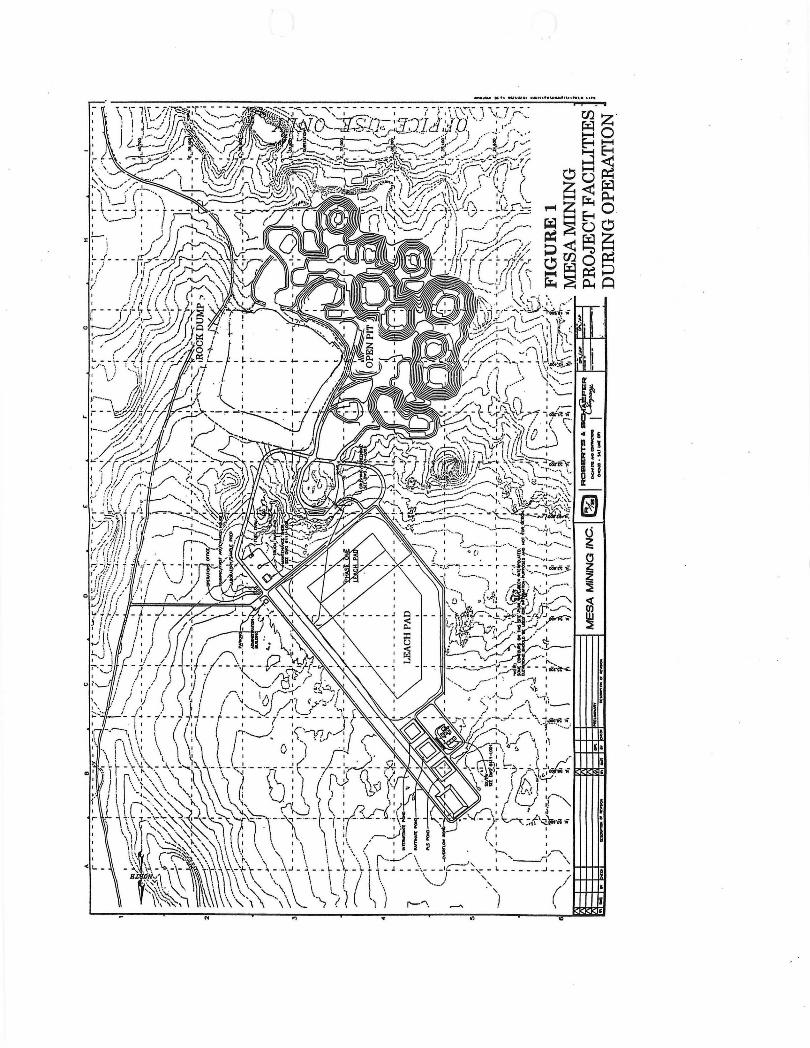
pit mining techniques, including drilling, blasting, loading and truck hauling. Rock containing no copper will be placed in mined-out areas of the pit when possible, otherwise in a rock dump. The proposed the mine and processing facilities during operation are shown in Figure 1.
Blasting will be done once a day, during the early afternoon. Charge sizes will be limited to minimize noise. Water sprays and road watering will be used to minimize dust from loading and hauling.
The ore will be placed on the lined leach pad. A solution containing water and a small amount of sulfuric acid will be dripped onto the ore using drip emitters. The solution leaches ( dissolves) the copper from the ore and is collected in a solution pond. The copper-bearing solution will be pumped to the solvent extraction plant, where the copper is removed from the leach solution and transferred to a concentrated, pure electrolyte solution. The electrolyte is then either electrowon to produce pure copper sheets or crystallized to produce copper sulfate crystals. Mesa Mining is studying the two alternative products, and will decide which to produce in the next few months. Typical processing facilities are shown in Figures 2 and 3.
All process solutions are recirculated. Make-up water is needed only to replace water lost to evaporation, initial ore wetting and dust control.
Reclamation. The life of the mine will be about 10 years, unless more ore is found. At the end of the life of the mine, the area will be reclaimed to meet or exceed government standards. Reclamation will include: removal of all buildings and equipment, except for buildings requested to be left by the chapter~ rinsing of the leach pad and evaporation of excess water; flattening the slopes on the rock dump and leach pad to enhance revegetation; removing pond
liners, filling and levelling pond areas; covering of the rock dump, leach pad, ponds, plant area and road surfaces with stockpiled soil; revegetating disturbed areas with native plant species; and fencing the top of the open-pit slopes. Following reclamation, vegetation would be monitored and tended as needed for several years to ensure survival. Most of the reclaimed area would be available for grazing after the vegetation has been reestablished.
A portion of the open pit will be left open as allowed by current mining laws. Mesa Mining will work with Copperrnine Chapter to minimize the impact and/or to develop a beneficial use for this portion of the pit. Proposed reclamation is shown in Figure 4.
Employment. The project will employ about 200 persons for construction and 100 persons for mining and processing. Construction jobs will include the usual construction trades.
Production jobs will include: mine engineer, geologist, metallurgist, mine foreman, plant foreman, engineering technician, surveyor, driller, blaster, powderman, loader operator, truck driver, plant operator, mechanic, electrician, laborer, laboratory technician, purchasing agent, environmental and safety supervisor, environmental technician, warehouseman, clerk, and receptionist. Mesa Mining is committed to local and Navajo preference in employment and training, and will train Navajos for operating and supervisory positions.
Schedule
If permits and approvals can be obtained, construction will start in about one year. Mining would then commence about October, 1999.

Contacts
If you have questions, please call:
Fred B. Brost, P .E. Project Manager Mesa Mining Inc. 7564 N . Palm Circle Tucson, Arizona (520) 544-7872
Mr. Ahktar Zaman Director Navajo Nation Minerals Department PO Box 1910 Window Rock, AZ 86515 (520) 871-6340
Mr. Bennie Coho Excutive Director Navajo Nation EPA POBox 338 Window Rock, AZ 86515 (520) 871-7692
Ms. Bertha Spencer Realty Specialist BIA PO Box 1060 Gallup, NM 87305-1060 (520) 871-5938

PAUL L. RUSSELL, P. E. CONSULTING MINING ENGINEER
Mr. H. Mason Coggin, Director, State of Arizona, Department of Mines & Mineral Resources, 1502 West Washington Street, Phoenix, Arizona 85007.
, ..
6050 W. Yale Avenue Denver, Colorado 80227 Phone: (303) 986·6363
April 0, 1994
Re: Coconino Copper & Chemical Co. - 1940.
Dear Mr. Coggin:
Thank you for your interest in the 1940 data on the Coc~nino Copper & Chemcial Company. Enclosed, as promised, are the pictures and some notes of what went on while I was there.
The need to preserve data and pictures of early events of all types for future reference is essential if we are to have a useable record of our early history. I became acutely a~,are of this in the 1970's t"hen I ~"rote "The History of Western Oil Shale" (now out of print), and again in the late 1980's when I wrote "Oil Shales of the World, Th~ir Orig i n, Occurrence & Exploitation (flier enclosed), Needless to say I did a lot of se a rching for d a ta and pictures.
I r e gret to r e port that I can offer no a dditional re co rds r egarding earl y operat i on of Arizona mines. For the most part my loinin g career was spent in other areas. Howeve r, I a m a Reg i ste r ed Hining Engineer in Arizona, Certificate # 1356 .
~y Int e res t in the Indian area of Arizona is a natural one since I was born at Keam s Can yo n and grew up 1n Flag staff,
I wo uld appreciate n o tice of receipt of this informat ion.
If I can be of further assist a nce please adv ise.
Paul L. Russ e ll
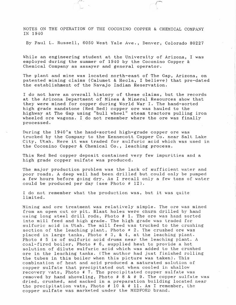
NOTES ON THE OPERATION OF THE COCONINO COPPER & CHEMICAL COMPANY IN 1940
By Paul L. Russell, 6050 West Yale Ave., Denver, Colorado 80227
While an engineering student at the University of Arizona, I was employed during the summer of 1940 by the Coconino Copper & Chemical Company as assayer and general operator.
The plant and mine was located north-east of The Gap, Arizona, on patented mining claims (Calumet & Hecla, I believe) that pre-dated the establishment of the Navajo Indian Reservation.
I do not have an overall history of these claims, but the records at the Arizona Department of Mines & Mineral Resources show that they were mined for copper during World War I. The hand-sorted high grade sandstone (Red Bed) copper ore was hauled to the highway at The Gap using "bull wheel" steam tractors pulling iron wheeled ore wagons. I do not remember where the ore was finally processed.
During the 1940's the hand-sorted high-grade copper ore was trucked by the Company to the Kennecott Copper Co. near Salt Lake City, Utah. Here it was traded for sulfuric acid which was used in the Coconino Copper & Chemical Co., leaching process.
This Red Bed copper deposit contained very few impurities and a high grade copper sulfate was produced.
The major production problem was the lack of sufficient water and poor roads. A deep well had been drilled but could only be pumped a few hours before going dry. As I recall only a few tons of water could be produced per day (see Photo # 12).
I do not remember what the production was, but it was quite limited.
Mining and ore treatment was relatively simple. The ore was mined from an open cut or pit. Blast holes were churn drilled by hand using long steel drill rods, Photo # 1. The ore was hand sorted into mill feed and high grade. The high grade was traded for sulfuric acid in Utah. The mill feed ~as trucked to the crushing section of the leaching plant, Photo ~ 2. The crushed ore was placed in large tanks, Photo # 3, & 4, at the leaching plant. Photo # 5 is of sulfuric acid drums near the leaching plant. A coal-fired boiler, Photo # 6, supplied heat to provide a hot solution of dilute sulfuric acid which was added to the crushed ore in the leaching tanks. (The author had just finished rolling the tubes in this boiler when this picture was taken). This combination of heat and acid produced a saturated solution of copper sulfate that precipitated out when cooled in shallow recovery vats, Photo # 7. The precipitated copper sulfate was removed by hand shoveling, Photo # 8 & # 9. The copper sulfate was dried, crushed, and sacked in a preparation building located near the precipitation vats, Photo # 10 & # 11. As I remember, the copper sulfate was marketed under the MEDFORD brand.

)
The crushed leached material was hand shoveled from the three leaching tanks and disposed of on the waste dump. The cycle was then repeated.
Photo # 12 shows the pumphouse about mid-way between the mill and the leaching vats. The water tank is to the left of the mill, assay office to the right and the tailing dump is right-center. The market for the product was quite good. In fact the Company hired a salesman who in his first or second call r eceive d an o r der that would have required the next 20-odd years to produ ce . The salesman resigned.
OTHER TRIVIA:
Since the mine and plant were surrounde d by the Na v ajo Indian Reservati on, most of the operating crew was Nav a jo.
The Copper Mine Trading Post, Photo if 13, was operated by Babbitt Brothers of Flagstaff. What apparently had been a storagewarehouse building near the Trading Post was used as a bunkhouse by the Company, Photo # 14.
From the mill-assay area, I was able to see over 30 rugs being woven at one time.
The acid-resistant chrome shovels used to remove the copper suI fate from the prec ipi ta tion vats were "borro,.,red" between uses by the Navajos and had to be rounded up each time they were needed again. They were always found.
One Navajo who worked at the mill was a genius in anticipating break-downs and was always gone when needed. He had recently married a young squaw. I asked him how much he had paid for his bride. He replied about as follows "I gave some sheep, a horse, a concho belt (etc.) "She did not know how to weave-I had to teach her. She had no sheep-I had to buy her some. She did not cook well-I had to teach her." A couple of other problems were mentioned also. He then said "You know I think I got cheated."
~ter~st~ experience!
/ ~~~ Paul L. Russell.

-F'it",: J.e 1'111. To: Wlilltm C. Epl.,
........... ... _- .....
ANTILLES RESOURCES LTD. N. 10220 Nevada Street, Suite 70 Spokane, Washington 99218 (509) 467-5200" FAX (509) 467-5045
\
21 Febntary 1995 VSE SYMBOL: AR Y.
ARIZONA C()})PER OXIDE DEPOSIT TO BE ACQUIRED
:\~TILLES RESOt.:RCES LTD. !l1Ul01111Ces that it has agr~ed to nma!gamute with - "-
American Ctippermine Rc~ources Ltd . (ACRL). ~ pri'l'[)te British ColumbiLl COlllp::my, in mder tu portil:ipatc in the deY.elopment of ACRL's \Vhite Mesa copper o\:ide depo~it located in Northem AI'izol1a . Ross Glanville and Associate~ Ltd. ho\'l~ calculated the \'uille of this deposit. b3sed 011 the net present n:t!uc of the projected c~sh !10Wis. to be approximately USS22,OOO.OOO.
The White M~sa property compri~e~ 1 0,000 ~cres ot' Nonlj() Ri:sen·utioli lunds 311d 188 acres oj' pat~nt~d claims. The! property has excellent infrar;trl!Chlre. with gl)od road nccess~ several 1"0\\ c:r Iin~s cn .. 'lssing the property, jd~al processing sitc!s and 8\'3ilnhle labor nearb~· .
. The mineable proven and probable ()I'e reser\'es utilized b~· Glatl\'ille wcre approximately 21 milli';n · t(ll·'S gr3dilig 0.36° 0 Cl1pper. Vv'ith additional drilling. the possible n~,!;erves ore c:xpcct~d :· fl.; be upgraded to probable reserves. Furtherl1111rl!. the: widespread copper mineralizitil..)llo"er the whole property and th~ geoph~·sical 3nomnlies suggest that the ultimate resen'es could be much greater than the 3 S million tOilS of culculated proven, prubable and possible reserves, . .
. Copper 11l1nerolillltitin nn the White Mesa deposit consists almost entirely t')f copper oxide mit1~rnls . The deposit is easily leachable (990
II recovery within n few weeks based on column lench tests) and appears ideal for development using low cost heap le31;hing and modem SX"EW Cl'lpper extracti(lIl methods. The pIon is to carry out open-pit mining :1t !1 prodllction rote of 12.000 tons per dny of ore (4 .2 million tons per ~·eor). The capital cost is estimated to be USS24 millit111. The~e figures moy be subject to revision up,,·ard~ depending upon the re.5ults of as 1.5 million feusihility study p!an.nc:d to commence os SL)On os possible.
Appro:';imatdy 90 drill holes h3'~ been ~ompktcd on the property. of \vhich 65 v,'ere drilled til ~he main deposit urea . Other studies including hydw!ogical. en\'irl.)nml!ntaL bit)logical, and cm.:heologicaL haw also been undertaken. Total c!xpenditures by ACRL hare been approximately tlSSl .S million to date.
•• . .1 ... . .. . ... . ... .. - ... _ • .••
'--1

Ie , f ,..
Antilles ilnd ACRl.. hu\e ugrl.!~J, slIbjC::l.:t to shurc::holJ~r UllU Vum.:ollvc:r Stol:k Exchange ~ppn,)\ wL to am:llgumatt" unJ continue:. :.is one: com puny under rh~ nume of AMALea. Undc::r tilL: tl!rms of th~ ag.n::..:m~nt thr~e Antillc::., C0mnWll sh:lr~s will be:: ex~hQngt!'d for one new sh:u~' (If AMAI .. CO olnd UIl<: ACRL shul'1.! (ullti~ip.1kJ h .'l be slIbje\.:t to a volulltary poolin.:J
• I:>
i.l~I\:I.!I1lt:nt) will he e'l:dwngt'd it)!' 1.0776 n\!\V ~horc5i of AtvtAl.CO.
At th~ datI.: uf t)II': amalgamation, .~,.l1til1-.:~ shurdwlders will rel:eive uppmximatdy -4.200,000 :-;h~1r~~ of the: i.tt1wl;:al1lail:d \,;omp:ln~' (5.9 million fLlll~ ' di!Ukd). ACRL shareholders will rC\:l.!in! UpPI\lxim;,:trdy 8 .. 3-W,OOO shal'c~ (!t9 milli(it1 1\111)' dilutl.!d) of tht: Ul1l.dgl;lmaicd \.:Ul\1p~ll~: of which ~,OOO.OOO "ill bt! issued free 1,,)1' all rc:stricti()/ls and 4,3-+0,000 shares will h~ h~JJ in \!~~J'll\\ ' , Th..: ~SCl'O\\ ~d shun~s will be rde<.t~ed ~llbjel.:l to c~)m pletion of Ll S2.000.000 \\url.. prllgram or an (lr~ r~sl.!r"': r~p(lrt u~~c;pt~lbk lI.) the Yuncl.)l!\er Sto~k
. Ex~:hllnge .
The I 0.000 ~(,:r~ PI\)pcrty is g(l\ 'cm~J by an ()p~r3ting agl'c!~ml!llt bl!twel:I1 the Navajo Nation and Mc~a Mining Inc .. u subsidiary (If ACRL whereby Mesa Mining c:.m uClJuin: 1000
0 of thl.' PWP\!l'ty ('SlIb.i~l:t to 01 b;.l~k-ill pllr~hasc oplion by the Nll\'~jO nation for 4YO 0 subject to nC:Jllliution ·(.lrbitrutiun) in rctllm for o'lUlll:.t! p.1yments ll{ tJSS55.000 pIllS a royalty on gros~ pn.lI.:e:c::ds, whic'h "urks Ll~I.:O!'ding to till.! pric&; of ~~,,)pper (60
0 "ith ~opp~r llnd~r USS 1.00 pcr P(lllllJ "-Iud go t.l "ith I.:I.)PPl!f bd\\ c:~ll USS 1.00 ilnd USS 1.25 p~r pound).
The Pi.lt~lltt.'d cluims are l)\\ ned ()utright by M~sD. Mining, \\ ith no royultic). Sinl.!e uppmximatd) lwO thirds (1J) of the I.!oppc:r production i'mH1 ~h~ proposC'd mining opel':ltioll will ~()1ll~ ii'om the lunds ICtlsl!d from th<: Nu\'uj() Nation und one third (1 ,'3) from the 100°0 0\\ (jed pntc:nted daiIlls~ th~ c::tJecti\c r~)yulty rateS on the full proJucliul1 will be abulit tWl.) thirds (2:3) nrlh~ sl:lled royalty,
:\ !inder~ fe,,- is p:.1yablc tl'l tht! Barrillgton COllllllLini<.:utii.)1l CrOllp li.)r its s~r\'ices.
• ON BEHALF OF THE BOARD
"John B, Hitt:" (signl!d)
JOh11 B. Hitt: PresidC:Ilt
l'Hl:..' , '.L.'iC0C; '!'.~ Si'·OI.'),: F\(H-tVIJE. H.'iS .VEl7flA';' .. u 'n()l 'ED ."()R DlS tl'nOI '} lJ ifff !.\'J't.'''-IHT/O.\ ' (OYI'!!.\'E[) flU.f'I.\'

. ~ - r'
" "
" ~ t
- ... ' ....
~ . ," .
"
File System ........................... _. __ ...... __ ._; ... .
File N 0 •.••••.••.••.••••••.•••••••••••••••••••••••••••••••••••
This ' chart to be used for gallons of gaa,oline requireq per month.
. . . ............. .. .......................
PRESENT OPE~AT;/7: (check X)
Production .......... ; Develo~ment .......... ; Financing .......... ; Sale of mine .......... ;
Experimental (sampling) .......... ; Owner's occasional trip .......... ;
Other (specify) .................................................................................................................................. : ........................... ..
PRODUCTION: Past and Future.
Approx. tons last 3 months
Approx. present rate per 3 months
Anticipated rate next 3 months
Ore Hauling Trucks
Compressors
Other Mine or Mill Eqpt. .
PRODUCT PRODUCED OR CONTEMPLA
I , ~
Tons
. . )."
.. ,
", :,:.
..' ~.
' .' -f.:
•. :;~.1: ,',
, "
J
f "'" ~ rONA DEPARTMENT OF MIN~.. ,\RESOURCES
Mineral Building. Fairgrounds Phoenix. Arizona
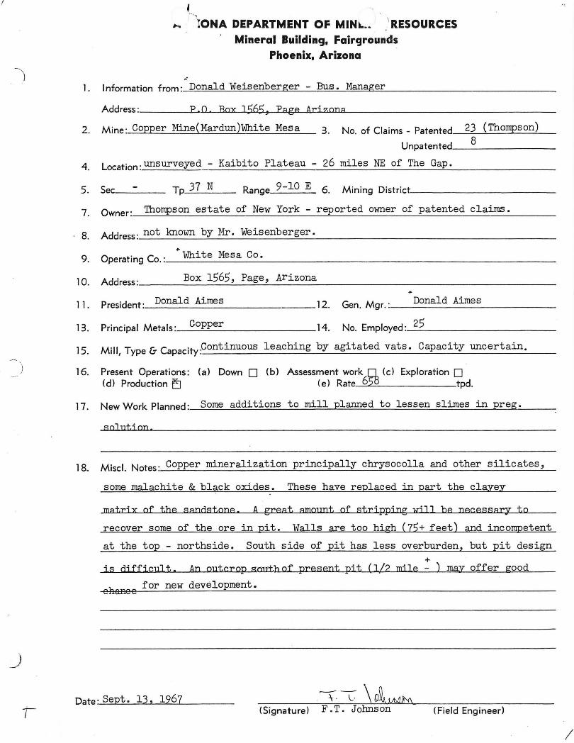
.' 1. Information from: Donald Weisenberger - Bus. Manager
Address: F. 0 Box 1565, Fa ge Ari z,ona
2 . Mine : Copper Mine(Mardun)White Mesa 3. No. of Claims _ Patented. __ 2::..3--,-(Th_o_mp~s_o_n...:.) __
Unpatented __ 8 ______ _
4. Location : unsurveyed - Kaibito Plateau - 26 miles NE of The Gap.
5. Sec ___ _ Tp 37 N Range 9-10 E 6. Mining District ___________ _
7 0 Thompson estate of New York - reported owner of patented claims. . wner: ___ ~~ ____________ ~ _______ ~ __________ _
8. Address: not known by Mr. Weisenberger •
9. ..
Operating Co. : __ Wh __ i_t_e_M_e_s_a_C_o_. ________________________ _
1 0 Add Box 1565, Page, Arizona . ress : _______ --.::..._-=-~ ______________________ _
11. President :_D_o_n_al_d_A_im_e __ s ________ 12. Donald Aimes Gen. Mgr. : ______________ _
13. Principal Metals: __ C-'op:....:p=--e_r ________ 14. No. Employed : __ 2_5 __________ _
15.
16.
Mill, Type & Capacitypontinuous leaching by agitated vats. Capacity uncertain.
Present Operations: (a) Down 0 (b) Assessment work D. (c) Exploration 0 (d) Production E:J (e) Rate 6~ tpd.
17. New Work Planned: Some additions to mill plarmed to lessen slimes in preg.
sol uti on.
18. Miscl. Notes : Copper mineralization principally chrysocolla and other silicates,
some malachite & black oxides. These have replaced in part the clayey
matri x of the sandstone. A great amOlmt of stri ppi ng wi J J be necessary to
recover some of the are in pit. Walls are too high (75+ feet) and incompetent
at the top - northside. South side of pit has less overburden, but pit design
+ is difficult. An outcrop smrt.h of present pit (112 mile - ) may offer good
h for new development. enanee
Date: Sept . 13, 1967 (Signature) F • T. Johnson (Field Engineer>
I

J
A "'"bNA DEPARTMENT OF MINEh RESOURCES Mineral Building. Fairgrounds
Phoenix. Arizona
1.
Address: P • 0, Box 1S65, Page Ax'
2. Mine: Copper Mine(Mardun)White Mesa 3. No" of Clai
4. Location: unsurveyed - Kaibito Plateau - 26 miles
5. Sec __ _ Tp 37 N Range 9-10 E 6.
7. Owner: Tho~son estate of :Uew York - reported owner of patented claims.
8. Address: not known by Mr, Weisenberger,
9. Operating Co. : __ lI-.:.Jh_i_t_e_Me_sa..:..:..-C_o_, ______________________ _
1 0 Add Box 1565, Page, Arizona . ress : _____ ~-'-.:..._---'=__''--_____________________ ____'
11. President: Donald Aimes 12 G M Donald Aimes . en. gr.: ____________ _
13. Principal Metals :_C_o--'p:....::p'-e_r ________ 14. No. Employed :_2=-:5==---_________ _
15.
16.
17.
Mill, Type & CapacityPontinuous .leaching by agitated vats, Capacity uncertain.
Present Operations: (a) Down 0 (b) Assessment work 0 (c) Exploration 0 (d) Production ~ (e) Rate 6~ tpd.
New Work Planned: " Some additions to mill plaIllled to lessen slimes in preg.
sollltjan.
1 8. Miscl. Notes: Copper mineralization principally chrysocol1a and other silicates,
some malachite & black oxides. These have replaced in part the clayey
matrix of the sandstone. A great amount of stripping will be necessa17 to
recover some of the ore in pit. Walls are too high (75+ feet) and iocon;>etent
at the top - northside. South side of pit has less overburden, "but pit design +
is difficult. An outcrop south of present pit (112 mi] e - ) ~ offer ~ood
ohance for new deve~l~op~me __ n_t_. _______________________ _
Date :Sept, 13, 1967 (Signature) F.TO\Johnson (Field Engineer)
Mine
District
Subject:
DEPARTMENT OF MINERAL RESOURCES
Zontelli Western
White Mesa
Visit
STATE OF ARIZONA
FIELD ENGINEERS REPORT
Date
Engineer
October 2, 1963
E.G. Williams
Quite a number of changes have taken place since the writers last visit April 10, 1963. One leach dump now has about 140,000 tons, another about 40,000 tons. At the time of the visit, equipment was filling in the space between the 2 dumps. When complete the dump will be about 225,000 tons.
The precipitating plant is now complete and consists of 13 cells a decant pond and a concrete drying slab. At the time of the visit 40 gpm was going thru the plant. They expected 500 gpm by October 1.
A complete change has been made in the personnel. Harho Saari, Supt., John J. Simmons, Mgr., and E. Coyle, plant foreman.

REPORT
l~\RDUN COMP :Jff White Mes~ Mining District
Coconino County, i~izona
April 30, 1945
Pursuant to instructions of C. H. Dunning, director, De;:a.rtment of Minerc.l Resources, a visit was mnde to the c.bove ;:lrOl)erty for the purpose of correcting, nnr lifying and/or extending the da.tr. COml)iled in the report of G • . i ... Ballcm, Depcrtment of ,Minera.1 Resources, dated November 17, 1942 . The holdings .cnd records of the Ma.rdun 'lv1ining CO:r.lpo.ny were examined on Al)ril 7, 8 o.nd 9, 1945, in cornp::!.DY with G. J •• Ballnm nnd O. F.VMc.rvin, c. l:artner in, and I!l3.Ilager of, the enterl1rise.
Conclusion
The essenti :::.1 f'c.cts of' the B:::ll~ re:;:;ort were ' in agreemont with the conditions noted cxce~jt those chQIlges which would necessarily follow tho devclol)ment ::md l;roduction o.ccomylished since thnt rCi .. ort. Such chungcs accrue to the benefit of thl3 :)rOIJOrty c.nd in no case ha.ve they been found to detract from the merit ::lS
~rcvious1y ro~orted.
There now c.pp3QrS to be inferred tonnage for an opernting period of 5-1/2 years at the rate of 60,000 tons per month., Such operation should yield a minimum of 1,728,000 :)ounds of cO:;ljcr IJer month at a direct cost of £1l.i1>roximato1y $0.0629 per ~ound of rocoverod cO? J..i0r on the ?rescnt smelting schedule ond return $0.07 per ?ound without r-romium, or $0 . 215 per ~ound with ,remium.
This enterprise in its completed l_ro:;osod SChedule oPI; ears to be one hoving the ndvantages ovar other major cOI::pcr producers of:
1. Less'init1~1 Co.l~ital OXI)enditurc ~:: er unit of :;roduction.
2. Loss manpower requirod :,cr unit af ) roduction.
3. Less critical matcrio1 neoded por unit of ~roduction.
As such it is deserving of el:!rly cX..,Jloi totion for war :mrI)oscs ::md throue;h investigation for j}ost-war l.: roduction :>os5ibi11 ties.
Conditions have boon cltored since tho ini ti~l r e;ort in the rcs:;,-,ects hereinafter discussod.
In addition to the origin~l hIlds l QG.sed from tho Indi:m Service the con~Slly has acquired leases on minerGl c1G.i~s formerly held by the Shnttuck-Denn Mining L om:l)~my, th~reby enlarging their holdings to n)~roximntely 1,155 acres.
Reports
In AUGust 1943 a United States Geologica.l Survey ~urty, under Charles B.

Re::.d, examined the c.ree. and esti~ted are reserves. This rei;ort hns not been :Jublished but a copy 1s nt h~d.
In M~rch 1945 the Supervising Engineers of the sait Lake City office ::.nd the Tucson office of the U. S. Bureau of Mines visited the prolJerty, making 6:A~cic.l study of the bonoficic.tion of the ore as ~ract1ccd by tho Mardun Comp~ny. Such re) ort has not been published and will r ·ossibly be withheld ;cnding additional l:J.boratory eAlierim0ntation.
Mining and dovelo::ID.:::mt nrc Quite closely associated as most of the: are wxtracted was for the ) ur:;osc of liroving ei thor Interal or vertical extensions of th~ knovm bodies. Thus thu extraction wns scattered over wide aroas, tho more concentrated I;art being on the Dutcbman cl1:lim 1-1/8 miles south of the mill and thu CO:)l~Cr World adjacent to the mill site. Scallor quantities were taken from throughout tho goneral area.
The gr:J.de and nature of del.-osition were found to bo COml)arablc between del)Osits as was the ratio in qunntity of shil':;.:, ing to milling ore,
Between October 1943 nnd March 1945 oro as follows vms extracted:
2,140 tons of shil)I,ing are averaging 6.56% cu.
3,282 tons of milling ore averaging 1.3% cu.
5,422 tons of wasted material averaging O.?% cu.
10,844 tons of all grades averaging 2.16% cu,
Thisp.verage grade of are is definitoly high,Jr them was indIcc..tod by the drilling :)reviously ac cOIIl?li shed , ~)lotted and re:)orted. Previous estimates of the grade of oro in other arecs must likewise be revised u:i.;wards IJroportlonatoly.
Mining costs arc extremely low ~s the de~osit lends itself to surface extraction. DrillIng is accom~lished by jackhacoers with halos spaced at 25 foot intervals. Holos arc drilled to a de:;th of 25 feet on the angle, or about 20 feet in vertical I)cmetra.tion, to cut the strcta.. Blllck :)owder is used for blasting, 12-1/2 :_ounds 110r 25 foot hole, and 1160 tons of are is broken :)er hole.
Hand loading into trucks for rernDv~l to the mill, stockpile or shipping :jile follows hand sort ing for grado.
Ore Reserves
The nature of tho de:::~osit is such that wide va.riance in estinmtes of are reserves would be obtained from indiVidual ongineers. The genera.lly s~tisfactory results of develo~)Ilent a.nd eXj)loration so far ox)oricnced lcnns fnvornbly tov;a.rd potentialities in extensions of IJresent known ex:~osures •
.I'..s of August of 1943 tho U.S.G.S. re:;ort tabulated are reserves in a total ,_ Jount of 16,260,000 tons, ~f which 2,260,000 tons ViaS indicated 8.nd 14,000,000 tons was inferred. Of the indicated ore 260,000 tons gra.ded from 1% to 4% co:;:;er ::l.l1d tho balance fron 0.310 to 1% co~;~;cr. This ostimato was attributed to the entire. district Olld not limited to the Mardun Com~.'any' s holJ.ings, although most of the
-2-

r
erecs are nO'il under the control of thct com.;any. Ore grodes were ::rediccted u)on the combined data of 'the Shattuck-Denn, Coronado !llld Mardun Com:;~m1es. Srunljling ex::erience hes shoi'm loss of vc.lue through ht:mdling srun:jles in the conventional wcy ':.'hlch :J.ccounts for actuc.l cO i. :~ er content in extr:J.ction exceeding :J.ntici:jated brede. l.:ucr, of the then inferred tonnege can now be tabuleted as indicc.ted ore follo','ling t110 mining :md develo~Jment horetofore described.
The racjor arecs wi thin the Mc.rdun Com:,:my's holdings, in the ::..- rcsent ste.t c.. ("I f clevelo=,ment, are as follm'ls:
.,1
1. Dutchm~ Claim
There arc four general e.rec.s, nll connected, within tho confines of this cL: iIl!. Of the 4, 3 have been subj0cted to extensive ox-; lorc.tion. The c.rea hn::; bo::n thorouGhly drilled to 0. dc~, th of 25 foot and tho cuttings :J.ssaycd. Humerous ~ ; i ts heve beon sunk to 0. de,.:th of 15 to 25 feet and the bottoms drilled to an cddition!11 25 foot dOI~th. Thoso ~j its c.ccount for much of tho are 1:l.illod, shi l:·:;:-;ed, and stock; ilod ns ~revi ously described.
The.: surfcce croo. cov ered is LaO, 000 squc~ro feot. Tho to:)ogre.:,.;hy o.nd drilling from tho ::;it bottoms indicate ore cxtonsions below the lowest visible horizon, but for the pur:)ose of this cnlcula tion only tho to::· 25 feet arc being considered es indicated oro. hs such thore nrc 860,000 tons of ore roo.soncbly eX:Joctod to bo gained from this clailil. Besed ul~on th8 extraction record such oro should c.veragc 2%~ in coz :er content. i
\1
2. Co,}:, er World Clnim
The ex::,osurc here ~ctue:.l1y extends over 80 lJart of "4 clains, 3 of which ~ro ~ :)art of tho Mardun COI!l~Amy' s holdings. ..\ .. n erea 1200 x 1200 feet has boon drilled on 25 foot centers to n de:>th of 25 foct, ::md sevorel long cuts Qx;,ose the sane oh~ractcr of orc to a local de: th of 50 feet. Drill holos in tho bottom of these cuts indicate ore to an 2.dditione.l 25 fe ot in de) th. Sorle ore has bo on minod from these cuts and 0. mill grade of 1.0%1 co:,:ier is l:,robablo from the nrea. Rough sorting to :::t 2.0% co):,er uill hee.d could be c.ccom:)lishod I:lcch:mically by wnsting overburden e.nd tho m :,Joverished sactions ~'li thin the wc.in zone as luning r,rogressed.
The indicated tonnage within the MGrdun claim limits is 2,875,000 tons of l%{.J.) oro, or :)ro~ortionetely less as the grade is increased. The inferred tonnage vertically is 3 or nore timos e.s great e.s indicated, and horizontal extension is :::tp~arent easterly and ~robably northorly. For ~ur~oses of calculation an esticcted 1,500,000 tons of 1. 5% ore will be a:;:,lied to the area.
-. ! , 3. CO~J:)er Hill (Indian loase)
This body stands out above the surrounding ::l c. teau lovel ::.rO::.ll1l8Iltly . . Some of tho e:::trlior ~ roduction wc.s obtained from this ::re8. and considerable drilling and bonc~hinG .e~;osed oro below en 8 to 16 foot overburden. Tho :::tree:. is n~j~~roxime:.tcq 600 x 900 feet on the surface with:: visibl e de~ ,th of 100 feot end can be cA_ected to yield 3,375,000 tons of ora baloN tho overburden to tho mose level. The gendral average vclue nnd sorting : ;ossibiliti os found on the CO:j~;er World, im:rn.edi::tely r.Jj::cent to tho north, should be a.~ . ~;lic :::tbl o here. Thus 1,750,000 tons of mill ore 0-;: em o:: : .roxirunte grnde of 1.5% is ~, robc..ble.
-3-

4. other smc.ller, or at least less ex)osed areas, are in eVidence over the entire loculi ty but no uttem:;t is made in this re:)Ort to estimate their :iotenti:::tl )roductive value. Such c.reas should be subjected to more detc.i1ed study c.nd ex~16rntion at some future time.
5. Indicated ore reserves, on the basis of current e~josures und eXl'erience , ~~n be recc.~itulated us follows:
Location Est. % Cu. Est. tonnu5° Cu. content
, Dutchmc.n Cl~im 2.0 860,000 17,200 tons
Co;pcr World 1.5 1,500,000 22,500 " CO;'I)er Hill 1.5 1!750 !000 261250 "
TOTAL 1.6% 4,110,000 65,950 tons
Milling I V
The mill hne boen increased to 0. cG.)c.ci ty of 5 tons :~ 8r hour and has been in oporc.tion at irregulc.r intervuls. Between Sc) tombor 1944 and February 1945 Qr;1)rox1mately .3,282 tons of ore from v,hich the high grude had been removed were mlled showing an o.verage gro.dc of 1.3% COij:·cr. A concentration ro.tio of 10:1 wo.s mointained and a cOHior recovery of 85% was o.veraged.
Concentrate shi:)tlcnts totc.lling .324 tons were made to Clarkdale and Hayden. ShiIJments to Clc.rkdalc avero.ged 12% cO:j~;er and thoso to Haydon o.p::roximntely 9% co~):~ er. This difforence is er..}lained in the shi::_:;ing schedule to Hnyden in which demurrage on rail cars rendered it er)edient to lowor the grade of shipments to tc.kc the greatest ndvantagc of the time element.
Shi~ments to Clarkdale were nade by truck at c. cost of $6.00 ~er ton. Shipmonts to H~don wero truckod to Fl~gst~f at a cost of $5.00 per ton and thence to the smelter by rail at a cost of $.3.73 l;er ton.
Tho concontrate is very desirable due to tho silica content (71.0%) ~nd low c.luminc. (4.2%). Vcrbc.l re:::;orts indicc.to that it was used o.s furnacc lining at the Clarkdale snelter.
~ ...
A llremium by Metals Reserve Com:)c.ny of l5¢ per :Jound is in effect whicl:. aggregates $0.2139 net return ~_or :·ound of co;; ::ocr when added to the base :,rice. Income on 0. 12% cO>i.cr concentrate us )roviously shilj~ed is as follows:
12% = 240 :.:;ounds - 16.8 ::oounds - 223.2 :;ounds 22.3.2 ?ounds x (11.775¢ - 2.5¢) =
$20.70 - $15.00 = $5.70 $.3.50 base l 10% of $5.70 = Si02 70.9% - (10 x 4.2!fo JU203 = 42) = 28.9% 28.9% ~ 1st rer unit = credit
Srunr·ling charge
Sl.lclter not return
-4-
$20.70
3.78
$16.92
0.50
$16.42

Premium: 97% of 240 l)OUn~ = 232. 8 ~Jounds 232.8 :!ounds @ I5)! :,cr ~ .;ound =
Net v~lue of concentrates
$34.92
$51. 34
In milling mine run oro, without havinG removed tho shiE;ing oro, Q higher : T _~do Llill head will bo n~intninGd. The estiJ:;:ctod o.verage co ~:;;or cont ent of the i nTorred oro is 1.6% of which 90% ::,lus is rccovernblo with nill im::;rovcIDonts to '~ Q described. Thus, assur:ling no im~rovODont in ratio of concentrc.tion, thG ~'::> llowing smelter settl':::r!l.cnt vlOuld rosult:
1. 6% cu. heads (j 905; recovery = 28. 8 ~JOunds COhjer .. 10: 1 rntio of conccmtrntos = 288 ~;ounds Co) ::·or in concentrates
288 ~ 20.2 = 267.8 ,ounds 267.8 ?ounds x (11.775~ 2.5¢) = $24.84 - $15.00 = $9.84 ~~3.50 bnso '" 10% of $9.84 Si02 70.9% - (10 x 4.2% A1203 = 42) = 28.9% 28.9% G lq;' ~;er unit· credit
Sc.m~)ling ck.rge
Smelter not return
PromiUl!l: 97% of 288 ~:ounds = 279.3 l'0unds 279.3 :)ounds @ 15¢ )cr ~ound =
Net valu·;;} of concentrates
O;orntionnl Progr~
$24.84
~4.48
0.29 4.19
$20.65
0.50
$20.15
41.89
$62.04
In vi ew of the novel dC:iosi tion hnb1 t of these bodies nnd the unique beneficintion systom develo:;od through the ingenuity of O. F. Marvin of the Mnrdun COO)~y, o~erntions cnnnot b ~ evaluated by the usual criteria. If conventional o»ration :,rncticeB need be a:.: :~,lied I no ~. rofi t :~ossibili ties would exist, and those cxo.ninors who hc.ve predioatod Ol)crations u) on conventional mctl:.ods hnvc of nccassi ty rendered adverse re:!orts.
The milling syst~ now in usc hu.s beon :;:. rovcn cconooically nnd motallurgico.lly sound and further 1n~,rov8Dents nro :..)ossible. The U. S. Bureau of Mines has already investigated the )lant in o~.'cr~tion nnd nrc re~. ortcd to hc.ve du:;licntcd resul ts in thzlir Snit Lake City laborntory. It h2.S beon found that co:::;er recovery .can bo increased viTi thout dar.:::::.ge to the conccntrntion rntio by addi tionnl disintegrators and collectors in the circuit. This h~G bc~n dc~onstrc.tcd by rerunning tnilings at tho nill nnd in the Burcnu's I nborntory.
Furthzr cost in:, rovc;;)'ent is : robc.blo through loaching of conccntrc.tos. The conccntrnt os are rnnenabla to ~onic. leuching and tests along this channel "':'-8 nOON in :rocess in the Buroeu of Min8s lc.borQ.tory. Th~ l~rocess now under investigation would yield CO ):?03r oxide having n vc.luG in excess of the narkct ) rice
-5-

-J--
I
of the metal itself. Thus, not only would the shipping and smelt1nb costs and losses be reduced or eliminated, but the net income per pound of recovered copper "~could be greatly increased. While such lenching would be desirable, in thnt the ~rosent marketing cost is greater than the oining and ndlling costs combined, it is not en absolute necossity in the economical opor~tlon of tho prop~rty.
Exclusive of this leaching foature the progrnm currently plnnnod is adaptod +0 tho peculiar conditions and characteristics found. Considerable loss of value ~y dusting is experioncod in handling the oro; the rocovery by milling being in ~:lct 0. dust rocov.:Jry Gyst om. It is therefore cX].)cdlent to tr!lnsfor the are as ~ittlQ as poss1ble. Handling c~n bo limited to ~ single step by arranging a movco.blc mll at tho pit fnce with doli very of the oro to the mill feed hor,per by n . power shovel. Tailings and pit ~sto would be removed by a tractor and carryall, or by mine cars tr~ed to a conveyor disposal system. The mill Vlould follow tho oro in tho mAnnor of 0. dredge.
A mdll having 0. ca~ac1ty of 20 tons per hour weighs, includ1ng diosel eloctrio powor, 22 tons nnd cnn bo mounted on a structural steel p1attor.m 19' x 30' square. The ontire struoturo could be moved forward on tracks or tractor trends ~long the pit floor os tho faco ,rogresses. Such movos would bo limitod as tho ahovel has a 25 toot swing radius and a cut 100 feet in width can be maintained.
A tontntive design of tho portable Lull inoludos the necessary additional units for improvod recovery o..nd an extraction of 9(Jf/, to 95% can be anticipated • .uso 1ncluded is :. r;ra-dry1ng c..rrtlIlg~ant which will greatly augcent co.poci ty and anse of o~erctions.
Operating costs with this arro.ngamcnt would approximcte:
Mining (480 tons por day):
1 1/2 yd. power shovel at $100.00 por day
1 - Cnt. & carryall nt $45.00 per day
Drilling & BlastinG at $15.00 l)cr day
Total
Milling:
Labor (3 operators, 1 utility o&n, 1 o.sscycr)
Power (150 h.~. diosel)
Fuel (Dryers)
Tota.l
$0.204
0.169
0.031
$0.10
$0.404
$0.240
Shovel o.nd caterl;illnr costs nrc 3sti:08.ted on a rental basis. .:"n ovor:lll ~ C;duction in :lCr ton costs could be effected by rurchasing thoso itens. The snov:;l, hr>.ving SO:!:lC 5 tines tho Dill c0.1;nci ty, -~lOuld serve to clininatc :l.lly obvious low grade na.tcri::l 3.S that L:!ltGriG.l is oasily detected. The cator:.)illar would
-6-

.... 4 ••
T
r.::lIilOVC such nine waste and mill to.ilings from tho l)it end bo D.v::l.ilnbl o for stril~~: ing o.nd o.-ploro.tory work. DrillinG would be o.ccomI:1ished with 0. wo.gon drill o:)cr::l.t ing on ono shift only. Eales \"iould bo drilled in the :;i t floor oohinu tho '":~ill o.dvc.ncG to dcternine dCl='th c.nd value of are bolow to be extro.cted on tho next "cut". With the USG of c. wngon drill ox:.)loro.tory drilling can bo nttainDd at con-3iaorQbl ·;) more de; ;th thGll is currently possible with 0. jo.ckhm:mlcr.
Th:: esti:.1::.:.ted cost of c ~)ort::.blc mill havinG a cc::cci ty of 480 tons :.er d~.y is ~~16,000.00. For the first unit the grao.tor ~, nrt of ho eCluipLl::mt is 3.t ho.nJ .':" .. 0.1(1 tho coot should not exceed $7,500.00. A ? ortcblc mill h8.ving Q ca::8.ci ty of ;)(:)0 tons l)or d ~~y Vlould cost a:. ) roxir.l::!toly $;23,000.00. Both tho Coz',er World Gnd 8():::)Gr Rill do)osi ts could efficiently SU:::jlily 0. Llill of the letter c:t:l[.ci ty with ::'. n:.:rked downwerd revision of ~;roduction costs. Mining eQui~)lnont cal:.: o.city is iduntic:tl with the re~uirononts of tho smo.llcr mill, and ::.:. 40% reduction in oxtra qtion cost is indico.tod with tho l:trger mill ca) o.city.
Wi th oo.ch milling uni t inst~:llQd, subsequont to tho first, o.ddi tiono.l Ccr.l:;
instnllo.tion, wo.tcr develo~ .. mcnt, h:::.ulil1G cClui::mcnt, etc. will b'3 rCCluired. Tho extent of noccsso.ry ex;ondituro for those itCT.1S is contingent u~on sever:::.l rectors which ~e :;enuingj those include thD 10nch ing ox';"',oriI:1onts, an o.ccess roo.d n~; ~;lic:-,
tion to il:l)rove the 26 milos of d'osert rond to the )~v,Jd highw:::..y , ::md athol' v2ri-8oblos. In ~my event such Co.l)ital outlo.y is not oxorbi tent in tho light of COr.JL1erci ~l tonnage co.lculated.
Ex:)onsos in tho o:)oro.tion of t l1C 3 D:.:tjor ox)osures on the b:::.sis of two 960 ton units and one 480 ton unit would 3.~,~~roxirz"te:
Mining $0.296 pOI' ton
Milling 0.200
Ho.uling 0.600
Roya.lty 0.201
Su::'orvisory &: Gan. ,"..cct. 0.250
$1.547 Tot~l Direct Costs
Not v:.:tluo ?Or ton of ro.w ore eftar concentra.tion on tho stlelter schedule is $2.01 at 12-cent co;::.cr o.nd $6.20 with benefit of )reI1iun. There a:.;~oars G":l~;le u.ifforontial to cover c~:,i tal return and ) rofi t w-i thin n relo.tively short r: oriod of o~ero.tion. Inferred ore is suffici ont to o~ornte the above 3 units for 0.
Ij eriod of 5-1/2 years. l .. :ldi tional oro _ rovon Vii thin this ~oriod should ~;rovide for n Duch longer ~,roducti ve lifo since no lim tin;; do:)osi tion fectors llc.vc b(3 3n discovered to dnte.
In s:;ito of th..:; unusuo.l cho.rc.ct0ristics of the fro:~,3rty it ha.s sufficLmt norit that it cc.n be considered ono of ~rizono.'s ~c.jor )otcntinl cOJ~ cr ; roducors.
Ea.rl F. Hastings Projects Engineer ;.rizonc. De~jQrt:J8nt of Minoral RGsources
-7-

/ /
/
\ j - ~ .
CO??F;R r...F-POSrrs OF "HITF..: MESA paNING DIS'rF.ICT
Co~2nipo Co'ypt:r, ArizoJl!..
B7 Charl_ B. Read R. D. Sample H. Ii. SuUwold, Jr.
Un! ted States GeoloGical Survey - August, 1943.
cmrrENTSa
~
Intr2ducto12D
}:levelopmmt and froduction
Geologic Features of the White Hella District
Mineral DepoSit!
lI1neral.ogy
Distribution
Fora and Character
Control
Repnes
Outlook
Illustration
£.uI
1
3
4
6
7
S
8
9
9
10
14
"Plate I. Geolog and Topography of mute Ilesa li!ininb Dietrict Coconino County! Arizona. Scale 1 a • 600 t •
Sectiona AA', EB', CC', DD'.
Plate II. Detail UaP8, Scala lA - 100'. /:.. Dutchman Claim. l!... A portion or the we8 tem end or the 'i'Ih1 te Vella U1n1ng District.
Plate III. Geologic Section. in .estern end or the WhiteUee& U1n1ng District. Sections AA t, nn " CC', DD'.
Summary or Assays ot Shattuck-Penn drill holes 1 -'SO. '
" ,~' ~'. ... .-,'
"
/

..
C()PPF.fi DEPOSITS OF TUE WHITE MESA UInING DIS'ff:ICT
Coconino Coupty, Aril9nA.
Buw.rxl The White Hesa $l1ning District. 18 an area or approximately 10.5
aquare mile. near the ... tem margin or the lalb1 to Plateau in unaurYeyed :37
Township", N, F.e.ngea 9 and 10 Eut, ~o Count)"', Ariamla. It 1s 112 mile.
northeut of Flag.tatt, the nearest rail bead rrom which 1t 1. acceslIlble bT
p8'f'ed and secondary road, and 1. at an elefttion or about 6400'. Inadequate
water supply and lsolation fro. supply eenten and eme1tera are factor8 1Ih1eh
haTe 1.nh1.bi teet developRlGnt and which may be expected t.o handiCAP m1.n1ng oper-
atlons.
Sporadic attemptl to develop reaerve. ot the district haft bMnunBuccesatul.,
nnd production baa been JII1nor. At. preaent., three compan1es are 1ntereate4
in de"f'81opraent, and .~ed in, or haft :reeent,q attempted, prospeeUng.
The copper de~slt1!1 occur in the upper portlon ot the neuly horizonta1J
h1~ cro.a-bedded, gray IanJo eandatone (Jurassic?). Occas1oDal large
tabular bedi_ and numeroua small pods or copper ore occur through an lntm-
ftl. of at l ... t lSO ref: t in the upper part of the formation. 'fbe depord. te
. are d1llaea1nat1one or aalacb1tet, copper silicates, and m1nor qtWltlt1ee of . occlh~JMGj
copper pitch and eulph1dea in sandstone, tbe copper m1nerala le~1'la1 as
cementing and cra1n-coat1ng _teriale. Orade varlee up to 15:', but lt 1&
doubtful it many of the depoal til wUl average JllUch higher than 1;'. The
larger bodies, 00_ or which conta1D nwral tboualmda ot t,cms, may be a
peotecl to avera&e less than 1.<. '1'be deposita .how a well defined f1eaure
control. I 0r1g1n may haYe been t.e1ethlll'llllll or meteoric, but there ls no
deci.l~ evidence bearing on this point.
-1-
\,
i·

"
The mineralization is too sporadic to permit accurate estimation of ore r&
eerves in the absence of extensive underground exploration or mining oper
ations. The following preliminary figurel are therefore only indicative
of the general. magnitude of the deposit. Approximately 2,250,000 tone of
are, averaging about 1% copper are indicated in the ore bodies that are ex
posed or penetrated by drill holes. Only a ff'IW thcttl!and tons of this total
can be claased as "measured ore" on the basis of available data, but 615,000
tons are reasonably assured. . The remaining 1,650.000 tons probably exist in
extensions, indicated by geologic ertdence, of the knolVIl are bodiee. In
addition, 14,000,000 is the inferred magnitude of an aggregate tonnage of
mineralized sandstone that may exist in "blind" ore bodies concealed in
undissected uplands.
Consideration of . the average grade and sise of the known deposits suggests
that large-scale development of these reserTes under present conditions
will be a marginal enterprise, even under favorable operating conditions.
The additional problem imposed by inadequate transportation facilities and
water supply enforce a pessimistic outlook. The relatively large inferred
reserves of concealed ore cannot be regarded as a mitigating factor, because
it is problematic whether concealed ore bodies can be discovered and developed
at reasonable costs.
It is recommended that further attempts to prospect or to develop copper re
serves of the district be prefaced by a careful analysis of mining and con
centra tiOD costs based on minimum tonnage estimates. Only in the event that.
such a survey indicates economic feaSibility, should additional steps in
development be undertaken.
-2-

INTRODUCTION.
The sandstone copper depos1 ts here described are near the northwest margin ot
the Kaibito Plateau in the Western Navajo Reservation, Coconino County, Ariz
ona. 'l'he area, known as the White 'Mesa llining DiCltrict, is in unsurveyed
TownShip 37 North, Ranges' and 10 East. It consietll of 9 patented and 28
unpatented* claim8, 2 mining and prospecting leases, an abandoned m1l1site
"* leue and a campsi te lease. Sporadic attempt. to mine the small deposi te of
high grade ore in the district have been futile. RecMtly, comprehemsive
prospecting by three companies ha& been initiated in a determined effort to
ascertain the feasibility of - devel~pL:,g, on a lart:e scal~, the lcnr grade
copper reserves in the district.
The area, approximately 10.5 square miles, which encompasses the claims and
leaee&,i& about 112 miles northeast of Flagstaff, Arizona, from which it is
accessible by' U. S. HighwaY' 89 to Gap Trading Post, and from there by ~;-t
road 26 miles to the Copper Mine Trading Post in the northwest portion of the
district,. 'l'he mean alt1tvAe 1s about 6400 feet and the local relief approx-
imate17 420 feet.
Annual precipitation is less than 10 inches, and surface and ground water a~
scarce in and adjacent to the district. The deficiency of water, isolation
from supply centers, and lack of adequate transportation routes are important
facton which have inhib1 ted development of t.he reserves of t-he district.
(* In the southwest part of the area, maps show two additional cl.ai.ms, the corners of which are not round in the field. )
-3-

· .
Only one report bearing on the geology of the White Mesa Mining District has
been published, a brief and general account by J. M. Hill (IICopper Deposits
of the White Mesa Mining District"; Un1 ted States Geological Survey Bulletin
540, pagel! 159-163, 1914). However, a number of confidential reports have
been prepared by geologists and engineers employed by companies intereeted in
the area, and several of these have been examined during the course of the
recent Geological Survey investigations. Company prospecting data have like
wise been consulted freely, and grateful acknowledgment of the courtesies of
the Shattuck-Denn, Coronado and Ilardun organizations in making these avail
able is here expres sed.
Field work of the GeolOgical s.urvey was begun late in March and was cOJtp1eted
early in July I 1943. The investigation was part of a program designed to
detel"lline the statws of marginal. copper deposite, and was undertaken by the
0e01ogical Survey at the requee t of the War Production Board. C. B. Read
1fU in charge of the Wbi te Mesa pro ject, and was assisted by H. H. Sul1wo1d
during the entire period or study. . R. D.Samp1e joined the party May, 23d,
and aided in the later stages of the work.
DEVELOPMENT AND PRODUCTION .
IIany operations in the White lIesa District were 1'irst attempted by Mormon
settlers, who, in the latter part or the last centu1j", located the mining
claims and opened many of the known ore bodies. An unknown. but relatively
small tonnage of high grade ore was recovered during the early period of
discovery and initial development.
-4-
In 1917, operations on the Little Dick and Copper World cl.aime were attempted
by tbeNavajo Copper Company. 1'1ro open cuts were developed, and 290,000
pounds of copper, ae well as a small quantity of silver are reported to have
been recovered. The operations were not profitable, and were disoontinued.
in 1918.
The Coconino Copper and Chemical Company began operations in the western part
of the district in 1939 and suspended them in 1940. Their activities were
ma1n~ on the Copper World and Dutchman cla1.ms. Complete records of pro-
duetion are not available. However, in 1940 they treated 4,584 tone of 3.13%
ore trom which 797,878 pounds of copper sulphate were 'produced and shipped.
The Kardun Company, which was formed. in 1941, m:.Uled 3000 to 3500 tons of ore
which yielded about 150 tons of concentrates estimated to contain 15 to 20%
copper. This Company operated on a mining lease obtained from the Navajo
Indian Serv1ce~ . In 1943 an option on the )(ardun lease 11'&8 acquired by the
Coronado Copper & Zinc Company. An intensive prospecting program, begun bi'- -
th,e Jlardun organization, has been continued in an effort to locate large law
grade ore bodies on the property. It is' reported that the Ilardun Company
4,rUlltd 17,000 teet of test holes with an average depth of 24 feet or less.
Records of a number ot these have be en examined, but others are lost. Known
locations are shown on map. Plate n-B.
The recent activities of the Coronado Company suggest thd the assay logs ot
these tests show unduly high copper c9ntent. In order to avoid confusion
the data are therefore withheld untU the matter i& clarified by shatt-
sinking and drilling now in progress. At present the engineers of the or-
ganisation are pessimistic regarding the possibilities of discovering large
ore bodies on the lease.
-5-
In 1926 the Shattuck-Denn l41ning Corporation acquired tax title on 9 patented
cl.a1ma in the White lIesa District. lIore recently they acquired options on
the unpatented claims, and in 1942 undertook a drilling and prospecting pro
gram in the Old Fort Hill area. About 4700 feet of core holes were drilled
and assayed. locations of these boles and summaries of mineralized sand
stone encountered are shown on the map; Plate II.
GEOLOGY.
)lost of the Kaibito Plateau, in the area studied, is surfaced by nearly hori
zontal, highly croa~bedded gr~ Jlavajo sandstone of Jarassic (?) age. About
1525 feet of' claatic sediments assigned to this unit were measured in an in
complete section at Echo Clitfa immediately west of the district where the
Navajo is underlain by Tri&5s1c clastic sediments and Permian limestones. To
the eaet, red claetic sediments assigned .to the Carmel formation rest on the
Navajo.
The major structural feature of the westem Kaibito Plateau is Echo Clitfs
monocline which trends north-nortbnst to north along the margin of the table
land. The steep dips of this nexure flatten gradulil.4 eastward into the
plateau ... but regional dip contihues eaet to southeast. Oblique normal faults
locally complicate the Echo Cliffe IIOnocline and extend north-e&5tward into
the plateau, where they are difficult to trace because or the homogenou,
nature of the Navajo sandstone which f'onu both walla at the surface.
GEOLOGIC FEATURES OF THE WHITE MESA DISTRICT.
!he White Mesa Mining District occupies an area some 10 miles East of the
Echo Cliffs monocline. Nearly hcrizontal Navajo s·andDtone, overlain by a
- 6 -
veneer or dune sand, is the surface rock throughout the dlJrtrict. Approx-
1mate17 420 f.et of the unit, constitut1ne the upper portion ot the formation,
are exposed 1n the area.
The tract.moe pattem of the White llesa D1etr1ct 18 .. own in .Plat.- I md II.
Fault fUSure8 trend north-northwest and 8OUtb-aoUt.heaet 1n the western part
of tbed18triot. Most or theee Ghent a alip do1m to the west and. northweat.
Sheeted sones, tr&veraec1 by' parallel tQ Bub-parallel faults and joints, eae
_rg1Da]. to the major fissures. A eet or master joints, trending northeut, .(
intersects theBe fracturea, foming a complex system. In the cent..""al and
eastern portions of the d1atriot, northeast trending _tor join1:8 cono t1 tute
the dominant r1esurea. Reats or silicified. brecc1a. and gouge charact.er1u
the 1ault8. Ve1nleta or cl1alcedolV' and, IIIOre rarely, calcite occur in the
f'au.lt sones and walla. 'Ibe major jo1nta al80 comonly &bow extensive 8i1-
icitication.
Tbe copper deposlta ot the White J:eaa J41.n1ng DiRtr1ct 'V'Ill'7 t!'OIl large, loIr
gre.de, tatJular bod1 .. to amall 1rregu.l.a!' pods and ve1u of h1&ber grade ore.
&bat of the .. U-expose4 bod1u are along or near IOMa ot south, southeast,
or nortbeaet tlvnd1ng joint or tault t1awrea wh1ch constitute the dom1~t
structural control ot ore deposition. Tho deposita have a very l1m1ted
vertical extent., and few 8bo'1f th1cknee888 which exceed 50 reet. the majority
are 811111larly l1ra1ted horisont.aJ.4r. Grade varies w1d.e~ but 18 predom1natel.y
lair, ancl tor the district a8 a whole wUl not exceed)$/ Interred reserves
of the lOW-gN(ie ore are large, but. the CORt or exploring the depos1 ts will
p1'O bably be high, due to the large 81'8& which must be prospected.
-7-

MINERALOOY.
Jlalachi te is the most important cDpper mineral in the district and is usua1l.y
aeeociate~ with chrysacolla. (The exact composition of the copper silicates
has not been determined. Clays, which are the common ceaenting minerals in
the Navajo eanciBtone, have been combined with soluble copper compounds, fOnl-
1ng copper carbonates disseminated in .:la.y, Silicates, and oxides; cf. Clark,
F.W. - The Data of Geochemistry; United States Geological Survey Bulletin 770,
pages 670-680, 1934.) These two minerals are disseminated through the
sandstone in which they partially fill pore spaces, form coe. tings on grains,
and occasionally occur as veinletB.
Copper pitch occurs in. the wall rock of fiSSures, where it frequently fone
a halo around disseminations of chalconi te or bomi teo 'l'he small quanti ties
of both oxides and sulphides make their economic consideration negligible.
Gangue, in addition to sand grains comprising the eandrlone, is mainly chal
cedon)" which occura in anastomosing stringers &8socia1ie4 with the higher t
grades of ore. ' Veinleta of calcite are rare. Limon1 te is commo~.l.y' dis-
seminated in the sandstone as variable but rarely extensive halos around
the copper bodiea.
DISTHIBtJTION.
Large low-grade copper deposits are ~y restricted to the northwest portion
of the district in the area between the Ida )I. Smyth and Eastern Star faulu.
The most notable of these are the Little Dick and its possible Grand Pacific
Extension, the Copper World, and the California deposits. Series of closely
spaced small bodies occur on the Du tchman claim, and in the area of the
-8-

Coronado leue on and near Copper Hill and Old Fort Hill. A rather large,
but very low-grade, body 1s exposed on the Queen claim, and smaller ones
occur on the Sunset and Ray claims.
Throughout the district there are numerous small copper bodies. The dis-
tribution of the various exposed deposits and of their indicated or inferred
extensions is shown on the map - P'la tft I.
FOR)( dB CHARACTER.
The copper deposits are very irregular and pockety. As indicated above,
the larger, low-grade, tabular deposits are exemplified by the Little Dick,
Grand PFifio, Copper World, and California bodies, where weak mineraliz
ation occurs in large area" of sandstone. Drillhole records show that
these may exceed 80 feet in thickness. Such bodies are traversed by numer-
ous joint fissures, the walls of which frequently show stronger minera1i~tion
than doe" the intervening sandstone. The smaller, higher-grade ore bodies
often occur u disseminations in the walle of fissures, and are usually vein
or pod-like in character. Few haw been observed to extend as continuous
deposits tor a greater horizontal distance than 50 feet. It is probable
that their maximwD. vertical dimensions are approximately the same as those
of the tabular bodies.
CONTROL.
The majority ot the copper deposits examined are associated with joints, but
relative:Q' fn are adjacent to fault fissure!!!. In the western part of the
district, fissuring ls dominantlJ' south to southeast, although locally it
trends nearly eut. Farther east, most of the fissures associated with

copper deposits are northeastly trending. Copper mineralization is commonly
although not invariably strongest in the walls of the joint fissures, but
continues, with decreasing ~tensity, for a variable distance away from the
apparent feeders. Joints which aft strongly silicified appear to have con
sti tuted partial barriers t.o bopper-bearing solutions and to have caused the
waters to spread widely along bedding planes.
The White )(esa copper deposita are epigenetic alld are product8 of precip
itation trom dUute copper-bearing 6olutiona 'Which entered the Navajo sand
stone along fissures and spread along permeable l.a.::d.nae nay from these .
fractur ... ·· It is riot clear, however, whether the solutions were meteoric '
or telethermal •
. There has been some modification of' the orig1'nal form and composition of
the copper det»sits. Downward-moving surface W'ate1'8 have undoubtedly re
sulted in the oxidation of copper sulphides which were probably important
primar;r minerals in the dept)sits. Such Yawrs have caused rather l\ide
dissemination of original.JJ more l"ftstricted ciepollits u a result of leaching
and re-precipitation. "Sweating" ot the sandstone has apparently resulted
in concentration ot soluble copper minerala near the present topographic
surfaces.
RESERVES.
'!'he status of mining development in the White Mesa Mining District does not
permi t highly accuRte estimates of' copper reserves. The ensuing discussion
is an attempt to indicate the general magnitude of these reserves and their
approx1mate range in grade as determined in the course of the surface mapping.
- 10-

Drilling and u5ay data are available only in the western part of the distr1"
and have been frequently been used to supplement. outcrop data.
In te1"Dl8 of the class1!ication of ore reaerYes recently adopted by the Geolog
ical Survt!17 and Bureau of Uines (Engineering &; M1ning Joumal, Volume l.44,
110. 6, Page 94 - June, 1943) reserves ot ore in known ore bodies of the White
lies. District are herein clud..f1ed as 1nd1cated Ort, and po5flible reserves
that =y exist in concealed ore bodies are ca88ed as Werred ore. A sig
nificant portion of d.nd1oated ore, in ps.rts of ore bodies bounded by very
moderate extensiona from observed faces of ore in open cute, ehD.l.lowr shafts,
or short e.d1ts, 18 reasonably assured. The remainder of the ore in thi8 class,
although regarded ,-'1.th le98 aeaul"ance, is balieved to exist in farther exten-
sions ot the On! bodies. Outlines of these blocks (Platell I and II) are based
on geologic en-dance with little or no prospecting control. If further re-
finements in classification 'Were justified, a e1l&U traction of the indicated
ore 1I1ght be regarded as mea@Yreg, and a similarly small fraction around the
fringe of the assumed outlines might be regarded a8 inlerred ore. In this
report, however, 1nl!1:red or!. includes only those possible reserves which JlBY
be present, although not exposed, in undisaected mesaa am buttes. V .. timates
of thie c~8e ot reserves bae be;;: n calculated byapp1.y1ng the ratio of Volumes
of sed1JAenu to the volume of ore as measUred in adjacent outcrops. . .They are
not in an.r 8e~e accurate estimates, but they do pl'()v1de a reasonable indication
of the general order of magrU. tude of completely hidden (and still undiscovered)
rilserves.
~- ll .-

Grading 1% to 4% (in soattel"ed small bodies)
Grading 0.3% to 1% copper
(in a few large and malV small bodies)
TABULATION OF OBE REStEVFS
Wh1 te )fee. 18.n1ng District
INDICATED ORE
fteaBonably Assured
80,000 tons
535,OQO tons
615,000 tons
In Probable _ ExtensioRs
100,000 tons
1,46~.OOO ton,
1,645,000 tons
INFERRED ORE
In Conceales! Ore Bodies
In area weat or Eastern Star raul t
.. II east " II .. " Total
Total' Indicated Reserves
II Inferred Reserves
Grand Total
-- ,u-
Total
260,000 tons
2, OOQ, 000 tone
2,260,000 tons
7,250,000 tons
6,750.000 top,
14,000, 000 tons p
2,260,000 ton,
14,000.000 totll
16,260,000 tops
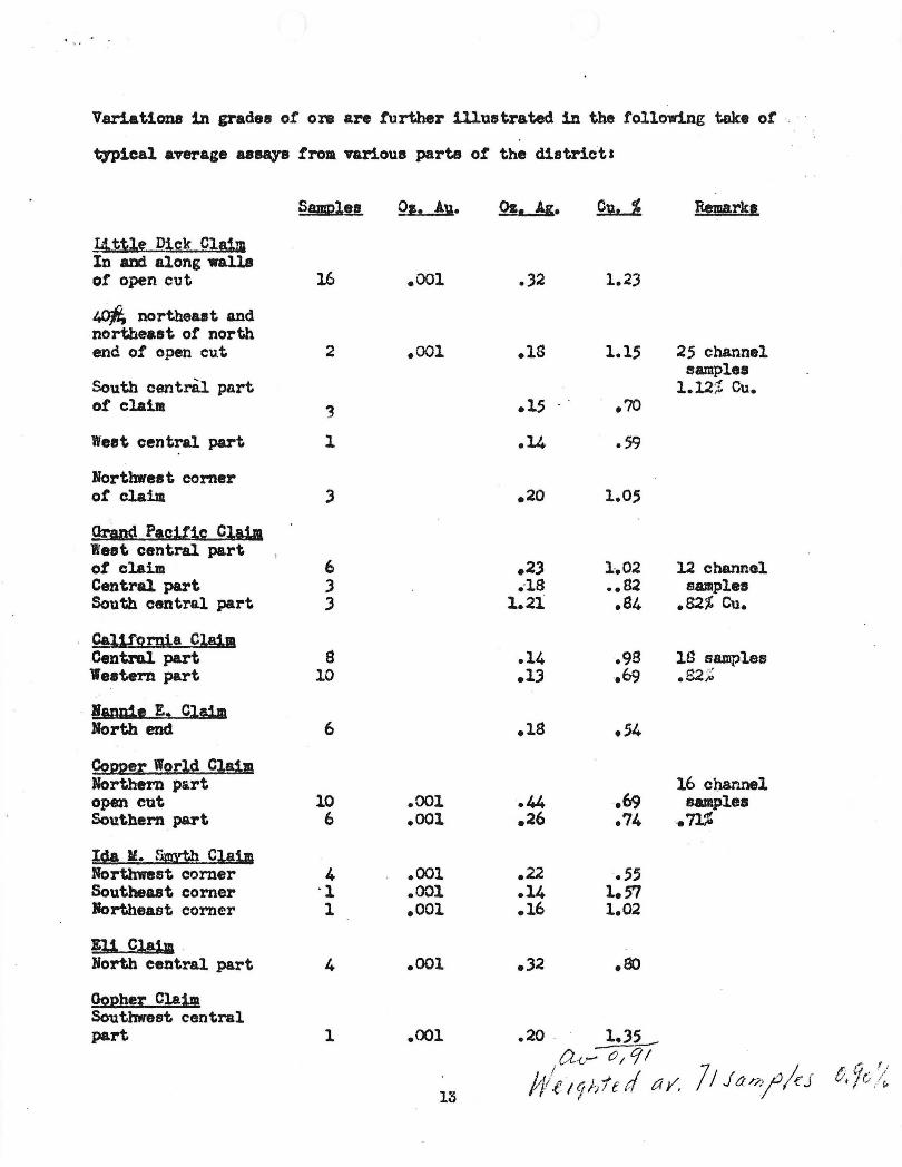
Variations in grades of ore are further Ulustrated in the following take ot .
typical average Uaay& froa various parts ot the district.
Samel,a 0,. Au. Qs. Ag. ~ Remark.
~ t~le Dick C1B1m In aDd along walls ot open cut 16 .001 • .32 1 • .2.3
IP/t; northeast and northeast of north end of open cut .001 .1S 1.15 25 channel
samples South centril part 1.l2;! Cu. of claila '3 .15 .70
West central part 1 .14 .59
Northwest corner or claim ) .20 1.05
OrandP!gif~g Claim West central part ot claim 6 .2) 1-,02 12 channol Central part .3 .-18 .,S2 samples South central part ) 1.21 .S4 .82% Cu.
Cal~rnia Claim Central part 9 .14 .98 lS samples '\f estern part 10 .1) .69 .S2 ~~
- Binnie E. Clalll North end 6 .19 .54
Cct22et World Claim Northern part 16ci).annel open cut 10 .001 .44 .69 samples Southern part 6 .001 .26 .74 .71%
Ida It. SMYth CJ£i.m Northwemt corner 4 .001 .22 .55 Southeast comer °1 .001 .14 1.57 Jortheast corner 1 .001 .16 1.02
Eli Claim -Borth central part 4 .001 .32 .80
002heJ: Claim Southwest central part 1 • <xu .20 ~
0..-1..,- () I C; I 7/ Jar?J//e-J t 9' '/ ff!~ 19 /;1e rI a y. t t.-.. / e,
13

The area west of the Eastern Star fault contains most of the larger ore bodies
and 1s believed. to offer the best chance for mining develoPment. Most of the
large .. low-grade copper depoeits occur in this part of the district, where
they 11e north of the Ida Ir. Smyth fault. The Little Dick .. Grand Pacific,
California .. and Copper World bodies together accoUnt for 323,000 tons of
measurable or indicated ore, and 1 .. 130,000 tons of inferred low-grade ore in
the estimates given. The Copper Hill area on the Mardun lease affordesome
promise, as does the Dutchman claim. It 113 considered posDible that about
10% of the uplands in this part of the district are minerali.zed to en average
depth of 50 feet, giving 7,250,000 tons implied ore which probably cannot be
found economically.
Numerous snall pods of high-grade ore occur in the eastern part of the dis
trict. 'there are a few large bodies, hOwever. Approximately 1% of the
uplands east of the Eastern Star fault are believed to be mineralized,
through an observed interval of 150 feet. The resultant 6,750,000 tons of
implied ore will be costly to find and probably cannot be recovered econom
icall;r.
OUTIDOK.
Possibil1ties for large coppeI'-m1ning operation in the White lIesa Jfin1ng dis
trict are not high in the immediate future. The ewmnation of the reserves
indicates a large probab1e and possible tonnage of ore, which at first glance
Idght be considered attractive to mining companies. The grade, however, is
1011' and will average less than 1% copper. There is little to ~ugge8t that
numerous large depoei ts of the low-grade material will be found, and abundant
reason to believe that most of the bodies will contain not more than a few
- 14-
' , 1.
thousand tons. Deposita such as the Little Dick, Copper World and California L::"'''~O~A-rION l-oR
are clearly in the minority. E.t .... · 19 tee of reserves in the area will be costly
because ot: the large areas which must be drilled on close centers in order to
block out known ore. bodies or to find 1n!erred ones. Open pit mining oper-
a tiona require th I remoYal. of large tonnages of barren or 'Yery low-grade sand-
stone in order to search out and recover ore-pods 'Which may characterize the
supposed large tabular deposi te. Furthemore, such operations cannot long be
restricted to a narrowlY circumscribed portion of the district. Costs of
constructing roads, trucking ore to mills, and moving mining machinery from
one location to another will therefore be considerable.
The White Mesa Mining District is 112 miles from rail head at Flagstaff and
approx1.mateJr 175 miles to the nearest smelter at Clmdale, Arizona.
Beneficiation will be neceSS8r,y to obtain, in sufficient tonnages, a product
which can be profitably shipped. The White Mee&. ore will leach well, but
the present water supply- of the district is inadequate for such an operation,
and conditione are unfavorable for a.rry large inerease by additional drilling.
Although it would be physically possible to obtain eurface water from the
Colorado at lee 'I!I FeTr7 or Navaho Creek, about 20 miles north or northeast of
the district, and at far lower eleTation, costs of installing and maintaining
a pumping systea 'Would pro bably be prohibi ti vee
A ciry-milling process, which is reported to yield. A. 20% concentrate with a
rather high efficiency, has been developed by the Mardun Company. A.~ the
process is still in the experimental stage!, hcmever, there are no data on
coste and recovery in larger milling operation. It is possible that the pro-
cess BaY offer a solution to concentrating problems in the district.
- 15-

' •• / ,f' • '" " "
It is suggested that any large-scale attempt to develop copper reserves in
. the district be prefaced bY's. careful analysis of mining and concentration
costa based on the mining of many SIIlall bodies which will average not higher
and probably less than 1$ copper. Uforts to block out ore tlhould be
ini tiated only in the event that Buch an economic 8UM'ey points to the
possibilit,y of deyelopment based on ~~nimum rather than maximum tonnage
expecta ti()n.
(Signed) C. B. READ.
R. D. SAMPIE
H. H. SULIlVOW, Jr • .
- 16-

· ~ ., -J
REPORT ON MARDUN COMPANY LEASE
BY
GEORGE A. BALLAM FIELD ENGINEER
ARIZONA DEPARTMENl' OF MINERAL RESOURCES
NOVEMBER 17, 1942
PURPOSE: Tv/o years ago the lessees of the property described herein approached the Reconstruction Finance Corporation in San Francisco relative to a mining loan for the purpose of mining and milling low grade copper ore by means of a new process. At that tine this process was in the experimental stages, and they were informed that further development wa~. recommended in order to qualify tor government aid. The process has since been-developed to a practical working operation, under the direction of a competent metallurgist, at an expenditure of some $40,000. The applicants feel that they are now prepared to submit their plans for reconsideration by the Reconstruction Finance Corporation. To this end they contacted the Department of Mineral Resources for aid in presenting these data. The folIo-fling report embraces a survey by a department field engineer to ascertain the extent to which the department may be justified in sponsoring their request for reconSideration of the project.
At the outset, it must be stated that the project -- both property and process -- is unique and apparently without precedent in the history of the various types of copper mining and milling practice. Tho novel features involved may tend to militate against due consideration of its merits and its potentialities as a substantial producer of copper. However, every phase of the operation has been carefully workod out by a competent metallurgist and tho results attained, now applied to a commercial operation, are embodied in this report.
GEOGRAPHICAL: Tho property is located on White Mesa Mining District, sometimes called Keams, in District Ho. 1 of the Navajo Indian Reservation in Coconino County, Arizona. The district in general is not included within a government survey, but the area in question was surveyed by Amherst Bakur in 1900, which survey was subsequently approved by the General Land Office. The app11~ants hold a mining lease to 595 acres of tribal Indian lands from the Department of the Interior on a 10% royalty basis. A cOl~ of this lease is apnended.(Exhibit ) - ----
The Mardun lease is situated 26 miles north of tho Gap, an Indian trading post some 30 milcs north of Cameron on U. S. Highway 89. (E7~ibit ) Leaving the highway at the Gap, a fair road ascends the White Mesa and traverses a rolling and sandy country to the mine. For a distance of about 10 miles, crossing a bowllike depression, conSiderable clay is admixed IT.lth the sand and the road is good throughout most of the year. The entirc distance of 26 miles can readily be icproved by means of grader with the use of a bulldozer in places at a cost not to exceed $500 per mile. A~plication for ro~d improvement und maintenance is being made through the Indian Service under supervisions of tho mine access road program.
Elevation of the mine is 6220 feet. PreCipitation does not exceed 2 inches annually as reported by u station of the U. S. Weather Bureau located at Copper Mine Trading Post ndjoining tho ~Jroperty. This record covers the last 1'i ve

r
., :
MARDUM LEASE -2- November 17, 1942
years. Climate is invigorating and permits year round operation. The region is sparsely wooded with cedar and juniper, sutricient for domestic Durposes. There i~ little water developed in the area. However, a well has been drilled 1200 feet deep about 1500 feet from the Mardun mill and half that distance from their end line. Permission ha~ been obtained through the Indian Service to use this water. The well makes about 2000 gc.llons ~er day which is ample for domestic and cooling purposes.
GEOLOGY .AND MINER:J.OGY: The surface rocks of White Meso. are light-colored sr..n.dstones, probably of the Navajo series. Outcropping nearly everywhere, in places covered with a few feet of loose sand, these sandstones vary in color from c. crerumwhite through light browns nnd varying shades of blue and ~een. The beds dip generally toward the east at about 30 degrees, but are strongly cross-bedded and very uniformly stratified, the strata ranging from 0.1 inch to 2 inches in thickness. The strata are se~arated by what ap~ear to be thin layers of altered lime. The sandstone is very friable throughout its depth ~d as eVidenced by the well already mentioned, continues uniformly to a depth of 1200 reet. (Drillings from this well were s~pled and examined by ap~licant.) No other rocks nre found in the area traversed by writer, roughly about 10 square miles, and the ap:Jlicant asserts that the same formation exists over an area of 5 by 7 miles which he has tested by pits and drilling (Exhibit _____ ).
At frequent intervals, ~s indicated by attached photographs (Exhibit ), mesas rise abruptly from the surrounding plain to a hoight of 200 to 250 feet,-aid from 10 to 20 acres in extent. Those buttes are severely eroded and carry little overburden. As nearly as can be determined, they consist of identically the same type of sandstone as is encountered elsewhere.
The grains of send are unifo~ in size and cemented together by a calcareous material which has been rep1cced by va~Jing ~ounts of cop?er and iron minerals giving rise to the vari-colored strata. EVen the white sandstone contains aprreciable copper, about 0.2%, and some of the darker green stone runs well over 20% copper. In general, the lighter sh~des of blue and green indicate values of froc 2% to 5% cOIJ?er, but soce of the brown colored rocks run equally high. No copper-free sandstone has been found in this area by the applicant.
Black spots and stains occur at frequent intervals throughout the sandstone lcycrs. These were found to be extremely small crystels of a silver com~ound, probably halide or OXide, although only the silver Yielded a ponitive test. The applicant stntes that the tests have sho\vn us much as 4 ounces of silver in his concentrates. .Along the planes of moveI:.lent, eSl)ecially where co:!??er minerals have been concentrated to a greater extent, considerable unounts of cuprite arc encountered, undoubtedly a result of conversion of malachite by frictional heat. At these points, of which a score or more were examined, high grade copper has been extracted during the past fifty years. ShiyTIents of high grade malachite and cuprite are still being made from time to time by the Indians in the district. Juthou@; it has been reported that chrysocolla constitutes th" main cOPl)cr mineral in the district, in the area examined the writer found malachite predominating, and this is supported by analyses of the couccntratos :llready shi)ped which have been sho"om to be chiefly tho carbonate of copper. All of the sandstone carries nbout 0.01 ounce of gold, but so far no attem?t has been made to recover it.

-3- November 17, 1942
!ITSTOnY: The first mining operation of record vms cc.r.ried on by the Navajo Copper Company in 1916-17. This compQny shipped high grade ore cnd although there is no record of the ~ount shipped, several tLousend tons of ore were extracted und some 2000 feet of open cuts cnd tunnels m£1de. This operation wns immedic.tely adjncent to the northern boundary of the 11ardun lense.
The next activity occurred in 1937-38 when the Coconino Copper and Chemical Company attempted to leach ore to muke c. sulfnte product. A 50-ton loaching plant was installed on the present 5i to of the Viardun mill. W~ter was hculed c. distancG of 30 miles, acid being brought in from Salt Lake City. This comp~ny is no longer in opGration.
On M~rch 6, 1941, tho lAarc.lun COl:lpany wes formed [.s a co-pertnorship consisting of C. L. Duncan anci O. F. Marvin. The former is ovmcr of the C. L. Dunccn Company, with offices in San Francisco r~d Los Angeles. The l~ttor, for the past twenty-two years, has been engaged exclusively ln the fields of mining, metallurgy and chemistry. Much of his work has boen in relation to the treatment of or0S.
Prior to for~tion of this company, the applicant h~d spent considernble time in the devolopment of c process for the dry separation of copper minerals from tho Navajo sandstone of this area. Research was conducted in the laboratories of the Marvin Metals Inc. in California on this ore, for a period of seven months. From that time on, experimontc.l nnd development work has progressed and at the present time tho company is operating a 75-ton pilot plant on the Mardun lease. Between 2500 and 3000 tons of are have been milled successfully, some 150 tons of concentrates containing 50,000 pounds of copper have been shipped to the Phelps Dodge Smelter at Cl~rkdale (Exhibit ). Meanwhile, extensive drilling rrnd other test work hc.s been conducted in the~ediatc vicinity of the Mardun property.
1UNING DEVELOPl~: The area examined by the ayplicant, prior to seGking a lease, conprised about 35 s~uare ~les of the White MesQ district, roughly five miles east and west by seven north and south. This area was found to be niner~lized throughout. More intensive investigation was conducted in the area. now constituting the Mardun Lease together with a strip about ono mile 'wide ~djoining the · western boundary thereof. In this area numerous test holes Vlere sunk by drilling and digging, some 17,000 feet of drilling having been done, all of which was in copper bearing sandstone. Of the drilling, 8000 feet averaged a copper content in excess of 1.5%. The remainder or 9000 feet averaged from 0.4 to 0.5% copper, the upper 5 feet being of lowest grade, consisting largely of leached and weathE:red OVerburden.
The dug holes c.nd open cuts referred to ,'{Ore made for the lJUrpose of ' checking against the drill holes, nnd were found to run about 30% higher in co;) er content than the drill holes. This discrelJancy is only al)parent and is readily accounted for by the fact that this s~dstone diSintegrates very easily, naking it difficul t to drai7 cores. The extrenely fine O,nd friable cOlJper miner:::.l, mainly nala.chite, was lost to a considerable extent, es;~ecially under conditions of dry drilling necessitated by this type of rock.
In addition to test work done on this ground by the aJ...'plicnnt, further information was obtained from former work dona in the locality. An 800 foot cut made by Navajo Cop]cr Compc.ny sone 20 feet deep, (Exhibit ____ ) another 1000 foot

r
' < .
I)liiP.DUN LEASE -4- November 17, 1942
cut with tunnels ~ade by the same compQny, (Exhibit ___ ) the l200-foot well already mentioned, were sampled and assayed. Scores of smaller holes and cuts are to be found, the work of hibh graders in the past. The writer exa~mined ~bout one hundred o~enings, all of which revealed practically identiccl conditions of structure ~d mineralization. More recently, during the pO-st few months, the Shattuck Denn Cor~orction has been drilling land immediately surrounding the Mardun lease. In 40 holGs, ranging in de:;th from 80 feet to 150 feet, and S8IDlj10d every 4 feet, cO:L):Jer miner:ll showed in ever.! case, 'o'vi th a mininur.1 cOl)l)er content of 0.1% ::.nd Q maximUlll of about 7.0%. The a~J~·roy.ir.:lC.te c.verage no.s 0.7%.
1.cting uJjon ir..i'orIn3.tion obt:tinod, the ap:J1icant ~Toceeded to systeIllD.tically block ore wi thin an c.reo. now knOVffi as COIJjJor Hill and Old Fort Hill, lying ncar the southwest corner of the lease (E:ctlibit ). To this end, the surfaca of the antire mesa was drilled to a de:;th of 25 feet with 100 foot centers. Then, at the north end of COPIlcr Hill, 'which hero iE <.iuite ::'r8cipitous, benches wore bla.stod out Gt c.bout 25 foot vertica.l intervals. ThesG likewise were dl,'il1ed at an cmgle of 10 degrees toward the face and 25 feet in de~)th. This wes continued to the base of the hill. In all, 50 holes showed an average of 1. 8% COI)l)or, disregarding overburden of 8 to 16 feet, which, nevartheless, L:rgoly constitutes ore ancnable to the process used. (Exhibit ___ ).
As shown on thG ma~) (Exhibit), the dimensions of Copper Hill are approximately 770 feet by 680 feet. OMFort Hill comIlrises an area of 400 feet by 250 feet. On the basis of a depth of 150 feet for the formar and 50 feet for the latter, it indicates an ore body of 6,40Q,000 tons. Of this amount 33-1/3% runs 1.5% Cu, 50% averages 0.9% Cu, while the rerncining sixth is a;proxirnctely 0.2% Cu. Thus it will be a:p:~crent that the entire 6~ million tons averages about 1% Cu and contains about 120,000,000 l;ounds of the metal. This grade of ore constitutes an excellent mill hoad for the ~rocess.
On November 14 the wri tor took c. 60 foot channel sffi'il:i.ile down the north face o~ Cop,or Hill. One half of this cut was in the original face and badly weathered and leached. Assay showed 0.54% copper (E~~ibit ). On the west faea a channel sample was tclcen over 6 feet eXj)osed of a 16 foot bed ' which assayed 2. Cf/o c0111jer (Exhibi t_) •
Although no complete blocking of ore has been carriod out in other sectors of the lease, the entire area has been examined , anu in four other ; .lac03s, as indicated on the ma~ (Exhibi t_) blocking of ore has been IJartially completed. In ~ormation, extent and values, these were ~ound to be almost identical with Sector 4 described abova. In fact, it is the oI:inion of the af?licant that the entire area of the lense is uniform throughout. This belief a;) ears to be logical when it is remembered that the entir~ area is in Navajo sandstone exclusively, of similar formation, bedding, anu mineralogical structure.
MILLING PROCESS: In order to get a clear :;icture of the milling procedure , it is first necessary to review the tests carried out on the mineral, the essential phases of which were confirmed by the 'wTi tor. In the first place, the procens is Co segregation, rather than a concentration in the ordinery sense of the word. No consti tuent of the copper-bearing mineral i tsclf has to be dro:i.J:;ed, chemically or otherwise, Malachite has been concentrated alrec.dy by nature and it is only necessar.! to separate it from tho sand. The sand grains are extremely resistant

1MP.DUN LEASE -5- November 17, 1942
to fracture, well rounded, and of unifol~ size. 75% of the particles pass over a 30-mesh, and are retained on ~ 40-mcsh screen. Less than 0.1% are ~lus 30-mesh while only 3% pass 150-mesh. The copper mineral, malcchit6, on the other hand, is extrem31y light and fri~ble, consequently the sandstone diSintegrates readily, malachite segregating from sand ~~rticles as a fine dust, all minus 200-mesh, under tLo l~ro)er conditions of treatment. This finely-divided lll:'.lr.chite dust weighs 80 ~ounds to the cubic foot or occu~ies 25 cubic foot to the ton. As an illustration of its character, it must be transf orted to the smelter in a light metal box which fits within the body of a truck, being loaded from the baghouse through 3. valve and unloaded at the smelter by suction oquipr.;.cnt.
To separate the cOIY;Jer c~rboncte matrix from the ' sand grains embedded in it, a beater typo of disintegrating Dnchino is employed of 22 inch by 16 inch dimensions. On account of the abrasive :;,roperty of this sand, th3 diSintegrator blades are fac ud with ?ure cast tungsten carbide of 30-mesh size. (The process for production of this !!laterial is carried out under r;atents granted Mr. :Mcrvin in 1929. This treatmont increased the life of the blade in comparison with a nanganese blade over one hundred times.)
The ore, now l)Urtially diSintegrated, and all minus one-half inch, passes to a direct-fired rotary dryer where it is dried to u ~oint at which copf;er mineral will not adhere to the gangue. Dust liberated in the dryer is sucked into a baghouse. This dust has always exceeded 20% in cop~ier content. From tho dryer, the ore ~~asses under controlled suction to Go second diSintegrator of similar tYi.)e from which it is drawn into a set of Im:;Jax nir se:):lrators. This ol)'3ration is based on the yrinciple of a sudden decrease in velocity by increase in crOS$ section causing the larger and heavier particles (sund) to rlrop while the fin8ly-divided mineral remains in sus:;;:cnsion. Tailings from these separators pass to another disintegrntor of higher velOCity for a fin~l scouring, thence to a final bank of se,arators. illl copper minero.l is sucked to the baghouse where it settles on a sampling floor.
The follm7ing are typical re~JUlts of mill o)eratlon in October, 1942: (Exhibit_) •
Head 0.41% 0.60% 0.82% 1.9~
Tails 0.087% 0.094% 0.11% :0.34%
Cone. 13.97% 15.73% 16.9J1/o 21.7%
Recovery 80% 84% 87% 82%
Conc. Ratio 34·0 25.8 20.6 11.4
During this exonination by the writer, SCl.l!ll)les of the run of November 12, 1942, were taken and assayed by him as follows (ET~ibit ___ ):
1.92% 0.27% 20.7% 86% 10.8·
The foregOing o)cration has been dcvelo~~d into a continuous and automatic ~rocess. Only tvro men are employed to o~ernte this mill at its capacity of 75 tons per doy. ElectriC ?owor is generated for the mill and carrQ nearby. A cherndc~l end testing laboratory is oaintained in GJdition to a !!lachine shop with electric and acetylene equipment (Exhibit ___ ).
PROPOSED OPERATION: The operation :;,:rol~OsGd by arplicant will be on the basis of 1000 tons every 24 hours, which with an ~ssured lliill hend of from 0.75% to 1.0%

.. " .
T
MARDUN LEASE -6- November 17, 1942
copper will produce 15,000 pounds of copper daily (Exhibit_).
Quarrying will be accomplished by blasting from benches in the face of the hill, using holes of 25 foot center and depth charged with black powder. Mo.teric.l thus broken down will be moved by 3/4 yard power shovel into loc.ding bin 0i cable tramway and conveyed 1200 feet to 0 500 ton mill bin. From the bin, it will be fed by 0. pay type reciprocating feeder into a four-foot hammer type rock bre~er, thence passing into 0. 6x60 foot direct fired rotary dryer from which it wUl be fed into a four-foot disintegrator. Next it vlill or drawn into a bc.nk of two Impax air separators from which the tailings pass for further scouring to another diSintegrator and thence to a similar bank of cir separators from which they will be discharged to tnilings dump.
There 2.r8 three points from which concentrntes will be drawn off. Th3sc are tho dryer o.ne. tho two bo.nks of nir sepo.r.::..tors. 'rhis dust-lnden air conto.ining tho conc3ntrntes will be pnssed through dust-collacting equipment consisting of a Mul ~iclone c.:nd baghousG from. "",bieh they will be discha.rgcd to storage bins.
Labor requirements will bc two men per shift for the mill. For quarrying oporations three men per shift will be required on equipment, maintcnunCEl mr:n, povldel' Den, driller, and two or three common laborers will complete the labor noeds. Other requirements will consist of the operator, 0. bookkeeper anJcnomist. It is anticipated that the product will be tr~nsported to scelter under contract. The labor situ~tion is not very acute in this area. Navajo Indians cnn be utilized to some extent as they have not been impressed into agriculture as is the case with other Irdin....rlO in the Stnte.
Power will be generated by 360 H.P. Fairbanks Morse diesel engine directly connected to 250 KVA 3-phase 60 cycle alternator. All fuel oil will be purch~sed in Flagstaff at tank car prices and transported to the mine by back haul.
COSTS: Completo installation of 1000-ton mill, quarrying equipment, together with ~dditional camp facilities will cost $,80,000. Operating capitel to carry on until first returns are ~vailable amounts to $20,000, making a total cost of ~100,000 whic.h is the estimated minimum amount adequate for this project (Exhibit ____ ).
Operating costs as outlined (Exhibit ___ ) total $1,000 per day.
On this basis with a production of 15,000 pounds of copper daily, the cost per pound will not be in excess of 6-3/4 cents.
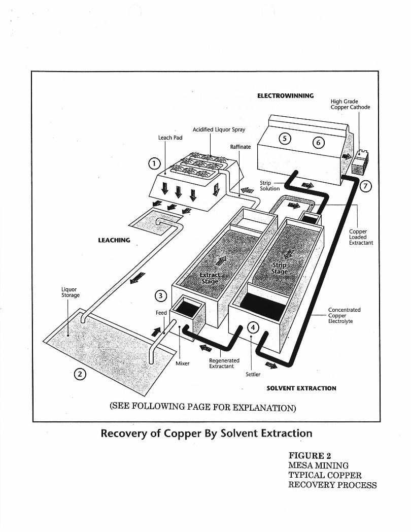
Liquor Storage
Leach Pad
ELECTROWINNING
Acidified Liquor Spray
Raffinate
Settler
High Grade Copper Cathode
Copper Loaded Extractant
Concentrated --- Copper
Electrolyte
SOLVENT EXTRACTION
(SEE FOLLOWING PAGE FOR EXPLANATION)
Recovery of Copper By Solvent Extraction
FIGURE 2 MESA MINING TYPICAL COPPER RECOVERY PROCESS

COPPER RECOVERY PROCESS (NUMBERS REFER TO FIGURE 2)
Copper is recovered by a hydrometallurgical process in which the metal is extracted entirely by the use of circulating solutions. Pure copper is produced at the mine site, with no smelting or refining required. All solutions are fully contained and recirculated. Water is required only to make up for evaporation and initial ore wetting. This process was developed in Arizona, and is nowused to produce about 25% ofthe worlds new copper. The process is as follows:
1. After mining, the ore is stacked on an impermeable pad liner in 10'-12' layers. Over time, additional layers are added on top of the previously leached layers, eventually reaching a height of about 150 feet.
2. Each layer is leached with a weak solution of sulfuric acid in water, yielding a pregnant (copper-bearing) solution. This solution is collected in perforated pipes laid on top of the liner and flows to a collection pond and a storage pond.
3. The pregnant solution is pumped to the solvent extraction plant where it is mixed with kerosene containirlg an extractant in the extract stage. The extractant removes the copper from the pregnant solution and reacidifies the now barren leach solution (called raffinate).
4. The kerosene (now containing the copper) and the raffinate separate in large swimming-pool like tank. The reacidified raffinate is pumped back to the leach pad to leach more copper. The kerosene is pumped to the strip stage where it is mixed with a more acidic solution, called electrolyte.
5. The electrolyte strips the copper from the kerosene. The barren kerosene is recirculated back to be mixed with the incoming pregnant solution (step 3, above). The electrolyte is pumped to the electrowinning tankhouse.
6. The electrowinning tankhouse contains a number of large electrowinning cells through which the electrolyte is circulated. Electric current is passed through the cells, causing the copper to be plated on to thin, stainless-steel plates. The depleted electrolyte (strip solution) flows back to the strip stage to strip more copper (step 5, above).
7. The pure (99.999% copper) copper sheets stripped from the stainless steel on a weekly basis. The plates are then returned to the cells to receive more copper. The copper sheets are bound into bundles and shipped directly to end users. No smelting or refining of the copper is required.
Mesa,Mining is considering production of copper sulfate crystals instead of copper metal. The process is identical except that in steps 6 and 7, copper sulfate crystals are produced from the electrolyte by crystallization.
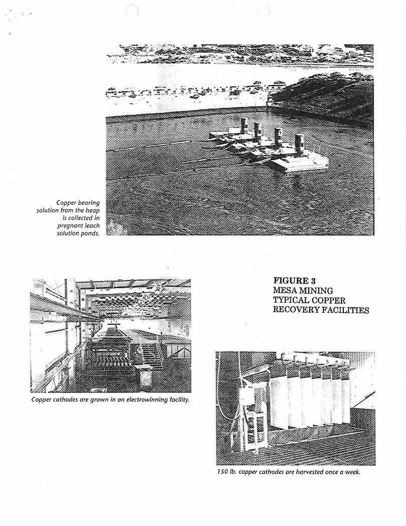
, ,
,
Copper bearing solution from the heap
is collected in pregnant leach solution ponds.
Copper cathodes are grown in an electrowinning facility.
FIGURE 3 MESA MINING TYPICAL COPPER RECOVERY FACILITIES
150 lb. copper cathodes are harvested once a week.

OPEN PIT
II
.~
FIGURE 4 MESA l\llNING PROJECT FACILITIES AFTER RECLAMATION
--",,<,, ' Scale 1"=1525' . .-::- ;;"
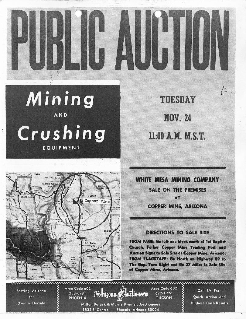
TUESDAY
11:00 A.M. M.S.T.

---' -- - --- - -----~--
.'.-.---.-----~, .. -, _ .. , . ..,.. .. --,.
D8 CAT - 14A W/DOZER & RIPPER -. LORAIN CR4 ~'LER CRANE - 40' BooM : :'
.; ,.
~" .. "' , ~ ,. '..... ,4,. " ,.-' .• t, / ': •
• D8 CAT 14A SERIES W/HYDRAULIC DOZER AND RIPPER
:;".,. :.,' ~"' .' D:S'CAT 2U SERIES W!tABLEDOZER
\ ,.;i , ,~,: , ~ '~ • L~~!lji~Jt'~~<L,E,R. ~~N'~ "'W/40' BOOM 8. DRAGLINE BUCKET' '. ; I, ~ .. ,: "diAIL4~ti~ ~RILL -,' ROTARY TYPE ON TRUCK
'r; <.,Ii ~ I t .~ ., . . ., ~ • • .... -.' ... 1 ",,'''': - ~_ . ' .. ::. i.,.
• PORTAB,LE INGERSOLL RAND COMPRESSOR MODEL P ' 141119$, M ~
.'·.;~'~~.'i;S~£Rll¥ SE~RCHI:i1TE . POWER PLANT f' " r: l:' J
• KEISLER CLAM SHELL BUCKET
• LETOURNEAU SCRAPER • P & H ELECTRIC CRANE " ~~!~5 ' ; ":.?: ~~ ! ;~~.Jl;t ~ • .:.:;!~~.~~-J:;" .i"';~:·~'I;~l·· toW )";~~:~4: ". ': ' . ..,,; .\, '';t;;.:.:::;;. ... :;: _
• GRACE WHEEL PACKER • DENVER GARDNER AIR COMPRESSOR (Diesel)
..... ,-,. 15.,' ·· ~R' ·VS'·Ii:iERS~· 0 / ,"' ",,' . . ~ :" : .. ,;: ' .~,~ .... . ,~ ·~ c .~ .. u., ,-, ' " "n , .. ,: .. ~ ... .(. ." "'" \. 'f :1 'J; " ~ I'
~';~~.I:) N';~'~ ~,~t;!1~}~:.~ ·.~ - <J ::. ~t~ ~:~ ~.t:'1;(!/.~,! J., ., ~~~~t: fi..-;. e~._ ir~~
.' !'IW~;SC'RE.EN·I'NG'''; Pt:A!N~;t l'p.: ' . . .. ; ,
.. ~ ' ·f Qib \·~I·r;~ ~(~.t,~~~~~ -tt. ~' ~+1r,~ .. ~1.~ .::.', ~'~~ :~ t~.,'~·;,··T~/· .. . ;~'1 :·.d~: ,:~~·~·~
jltl''!:~·').···''e~·~~.#IJi't~~·~.q·~'4~~·~~·~··~~~~rt-~':lit·'~r
• CEDAR RAPIDS DOUBtE~:lMP}Lttlt;'; IMpA'ti' ·'4,
BREAKER SIN #14390 WITH 2 BARBER GREEN " " 1'60~FT~' BELT CONV'EYORS POWERED BY'
TWIN' DIESELS
• PETTIBONE UNIVERSAL SCREEN (Like New)
• SAND CLASSIFIER W / TANKS AND COMPRESSOR
PUBLIC AUCTION MINING AND CRUSHING
EQUIPMENT OF
THE WHITE MESA MINING COMPANY
LOCATED AT
COPPER MINE, ARIZONA
TUE'SDA Y, NOVEMBER 24 11 :00 A.M. - M.S.T.
' ... .... , . . ,'
·,1
;. ~ .. )1 .

r · .. _. __ .- ._-- - ----
CEDAR RAPIDS IMPACT CRUSHER PETTIBONE UNIVERSAL SCREEN
" ,
PARTIAL ~ VIEW' OF PIPE
.•••••••••••••••. w •••••••••••••••••••••••••••••••••••••••••• wi ~ ... :.~ .......... ~~ .~~~ ... ~~ .. ~~ .... ,. ......... ,.,. .. ,. .. ~ ...... ~ "$ MAG!NETS - P'I p:e - TANKS . '\h'~ t .~ ;.\
, t1'A .... y .. A· •• "'.· ...... ;. .......... ••• ••• • ••• • •• "' ••••••• -.If ... -JY' ........... y ............... y......... . . • SHRADER 50" ELECTROMAGNET ;;:;. 20" MAGNET'
"" i . . ~ " , 't. " -.'. '. ' . '. ':'. " '. io' ; .'/~. n. .: ~ ~ .. 'j., " ~~
"'TANKS:' sOl),'io"'3o)OO GXC tWATER A~:D FUEL TANKS
Pumps, Electric Motors, Spare Parts & ·Iron, Conveyor Sections, Rollers,
7-Yd. KoringDumpsters, Yeager . Poftab'~3-C.u. :,Yd. Cement Mixer, Etc. I . • - . , ~. .,'i· - . ' ..
. ,.. ',' . 1000's · OF FEET. ~F , ALUMINUM AND ~:rEEL PIPE
SHOP EQUIPMENT: Monarch Latlie, Drill Press, HD Shop Grinder
TERMS OF SALE
Twenty-five per cent (25%) deposit is required of all bidders, balance to be paid before removal of purchases. All descriptions are believed to be correct, but the Auctioneer will not be responsible for advertiSing discrepancies or errors in nomenclature; everything sold as is, where is, and no guarantees or warranties are made or implied.
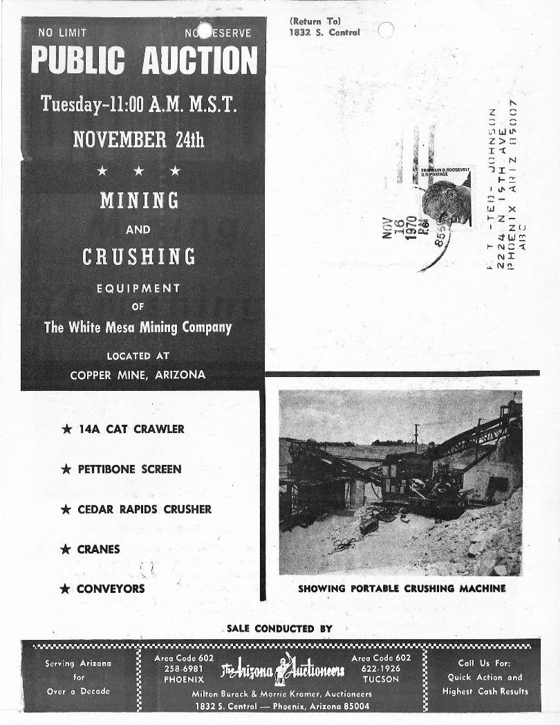
NceESERVE ' j' NO LIMIT "
'PUBliC AUCTION Tuesday-ll:OO A.M. M.S.T.
NOVEMBER 24th
* * * MINING
AND
CRUSHING EQUIPMENT
OF
The White Mesa Mining Company
LOCATED AT
COPPER MINE, ARIZONA
* 14A CAl CRAWLER
* PEnlBONE SCREEN
* CEDAR .RAPIDS · CRUSHER
* CRANES . , . ; r '-;.~ . 'J *. CONVEYORS
<Return To} 1832 S. Central
:,
z - '""' ~ ..., :./1 LJ IJ'
Z>:: I"'t :: N JI-I-~
I~ "'t ......
W X ~ 'Z'-
. I ZU ~W~
~N::'1: NI.
~' N '~
SHOWING PORTABLE CRUSHING MACHINE
SALE CONDUCTED BY