dnrc cabin site sale #868 broadwater county, montanamediaserver.dnrc.mt.gov/tlms_public/868.pdfwere...
TRANSCRIPT
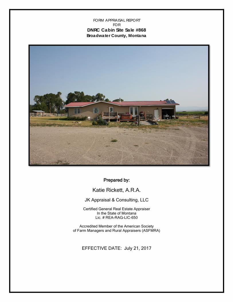
FORM APPRAISAL REPORT
FOR DNRC Cabin Site Sale #868 Broadwater County, Montana
Prepared by:
Katie Rickett, A.R.A.
JK Appraisal & Consulting, LLC
Certified General Real Estate Appraiser In the State of Montana
Lic. # REA-RAG-LIC-650
Accredited Member of the American Society of Farm Managers and Rural Appraisers (ASFMRA)
EFFECTIVE DATE: July 21, 2017

August 10, 2017
Department of Natural Resources and Conservation PO Box 201601 Helena, MT 59620 Attn: Emily Cooper RE: DNRC Cabin Site Sale #868 Dear Ms. Cooper Pursuant to your request, I have personally inspected and prepared an appraisal of the real property associated with the Department of Natural Resources and Conservation (DNRC) Cabin Site Sale #868 property located in Broadwater County, Montana. The property consists of one contiguous tract consisting of an estimated 9.5 acres with improvements. This property was appraised under several hypothetical conditions and two extraordinary assumptions The appraisal conducted herein is deemed to be an Appraisal Report that is presented to you in a form format, all in compliance with the current Uniform Standards of Professional Appraisal Practice (USPAP) guidelines. The objective of this analysis is to provide a credible opinion of market value for the possible sale of the 9.5 acre tract owned by the State of Montana. The improvements are currently owned by the lessee of the surrounding State of Montana ground. Intended users are State of Montana, Montana Board of Land Commissioners, Department of Natural Resources and Conservation (DNRC), and the Toston Land Group, LLC, Lessee. Based on my inspection and analysis, it is my opinion that as of July 21, 2017, the estimated market value of the subject property is as follows: Improvements CV: $247,000 Land Value-Only: $ 33,000
As A Whole: $280,000
This value is in terms of cash and considers the surface ownership rights of the property. This value excludes specific valuation of timber, mineral or water rights; the subject market does not delineate these particular rights during sales transactions. The real property is appraised in an “as-is” condition. This value does not include personal property, fixtures, emblements or intangible items. The appraisal assumes the property meets all requirements of county regulations.
I herewith deliver to you one electronic copy. With additional hard copies to be delivered if requested. I hereby certify that I have no interest, present or prospective, in the herein described property, and that my employment is in no way contingent upon the amount of the valuation. I certify that my opinion is based on a personal inspection of the subject property, a study of the data obtained, and my knowledge of real estate values in the subject market area.
Under the current USPAP, the Conduct section of the ETHICS RULE requires the appraiser to disclose any services regarding the subject property performed by the appraiser within the prior three years, as an appraiser or in any other capacity. I have had no dealings with the subject property in the past three years.
All market data and other data discussed, presented, utilized, and disclosed in this report shall
not be disclosed by any person(s) or entity reading, utilizing, and/or presenting the report by any means of communication, including but not limited to verbal, electronic, written, to any other party or entity without prior written permission of the signatory appraisers.
I trust this report will be found complete and satisfactory for your needs. If any additional
information is needed, please do not hesitate to contact the office. Your confidence in allowing me to serve you is greatly appreciated, and I have considered this work a privilege.
Respectfully submitted,

File #
Uniform Agricultural Appraisal Report
Prepared For:
Intended User:
Prepared By:
Date Prepared:
07212017084
EFFECTIVE DATE: July 21, 2017
Montana DNRC Trust Property #868
150 Smith Lane
Toston, MT 59643
Broadwater County, MT
Department of Natural Resource & Conservation
PO Box 201601
Helena, MT 59620
Attn: Emily Cooper
State of Montana
Montana Board of Land Commissioners
Department of Natural Resources & Conservation (DNRC)
Toston Land Group, LLC
JK Appraisal & Consulting, LLC
PO Box 691
Belgrade, MT 59714
Katie Rickett, A.R.A.
August 10, 2017
©1998-2017 AgWare, Inc. All Rights Reserved.

File #
Table of Contents
Page Title Page #
JK Appraisal & Consulting, LLC07212017084
Report Summary 1
Scope of Work 2
Scope of Work 3
Scope of Work 4
Market Value Definition 5
Area Description 6
Location Map 7
Area and Regional Data 8
Area and Regional Data 9
Area and Regional Data 10
Area and Regional Data 11
Area and Regional Data 12
Subject Land Description 13
Subject Improvements 14
Aerial Map 15
Photos 16
Photos 17
Photos 18
Subject History and Use 19
Cost Approach 20
Vacant Land Sales Grid 21
Vacant Sales Map 22
Sales Comparison Approach 23
Other Improvement Adjustment 24
Reconciliation 25
Limiting Conditions 26
Certification 27
UAAR®
©1998-2017 AgWare, Inc. All Rights Reserved.

File #
Uniform Agricultural Appraisal Report
Owner/Occupant: Total Deeded Acres:
Property Address: Effective Unit Size:
State/County: / Zip Code:
Property Location: Property Code #:
Highest & Best Use: "As If" Vacant FAMC Comd'ity Gp:
"As Improved" Primary Land Type:
Zoning: Primary Commodity:
Unit Type: Economic Sized Unit Supplemental/Add-On Unit
FEMA Community # FEMA Map # FEMA Zone/Date:
Legal Description: SEC TWP RNG Attached
Purpose of Report:
Use/Intended User(s):
Rights Appraised:
Value Definition: Attached
Assignment: Report Type:
Extent of Process/Scope of Work:
Pro
pe
rty
Id
en
tifi
ca
tio
n
Summary of Facts and Conclusions
Date of Inspection: Effective Date of Appraisal:
Value Indication - Cost Approach: $
- Income Approach: $
- Sales Comparison Approach: $
Opinion of Value: (Estimated Marketing Time months ) $
Cost of Additions:Cost of Repairs: $ $
Allocation: Land: $ $ / ( %)
Land Improvements: $ $ / ( %)
Structural Improvement Contribution: $ $ / ( %)
Non-Realty Items: $ $ / ( %)
Leased Fee Value (Remaining term of encumbrance ) $ / ( %)$Leasehold Value: $ / ( %)$
$ / ( 100 %)Overall Value:
Cash Rent Share Owner/Operator FAMC Suppl. AttachedIncome and Other Data Summary:( )Income Multiplier / (unit)Income Estimate: $
Expense Ratio / (unit)% Expense Estimate: $Overall Cap Rate: / (unit)% Net Property Income: $
Area-Regional-Market Area Data and Trends: Subject Property Rating:
Above Avg. Below N/A Above Avg. Below N/A Avg. Avg. Avg. Avg.
Value Trend Location
Sales Activity Trend Soil Quality/Productivity
Property Compatibility Improvement Rating
Effective Purchase Power Compatibility
Demand Rentability
Development Potential Market Appeal
Ap
pra
isa
l R
ep
ort
Su
mm
ary
Desirability Overall Property Rating
Page of
JK Appraisal & Consulting, LLC07212017084
Montana DNRC/Lessee150 Smith Lane, Toston
Montana Broadwater2 W of Toston
Rural HomesiteRural Homesite
NoneX
9.509.50
59741
Single Family HomeSingle Family Home
30007C 0725C 8/18/2014Lot in SE4SE4NW4 16 5N 2ETo provide a credible opinion of market valuePossible sell of the subject property/ State of Montana; Montana Board of Land Commissioners; DNRC; Toston Land Group, LLC
Fee Simple excluding reservations, easements, conveyances, restrictions, and encumbrances of record.
XAppraisal
Katie Rickett, A.R.A. inspected the subject property on April 11, 2017. This is the effectivedate of value. Market data was researched through local courthouse records, realtors, and other market participantsknowledgeable of the local market. Total acres are calculated from the Montana Cadastral Web-site and confirmed with thecounty assessor and legal description. Additional property and market data was researched and obtained from the DNRCweb-site. The sales were inspected and analyzed to arrive at an estimated value. Appropriate approaches to value wereimplemented.
July 21, 2017 July 21, 2017
280,800N/A
280,0003-9 280,000
33,000 3,474 120 0
247,000 26,000 880 00 Acre 00 Acre 0
29,474 Acre
XX
XXXXX
XXXXXXX
1 27
UAAR®
©1998-2017 AgWare, Inc. All Rights Reserved.

File #
USPAP, Organizational, or Other RequirementsReport Type:Date of Inspection: Date of Value Opinion: Date of Report:Scope of Work (Describe the amount and type of information researched and the analysis applied in this assignment. The Scope of Work includes, but
is not limited to the degree and extent of the property inspection; the extent of research into physical and economic factors affecting the property; the extent
of data research; and the type and extent of analysis applied to arrive at the opinions or conclusions. Additionally, describe sales availability & ability to
demonstrate market - "as vacant" - and "as improved" if applicable - or describe sales available to form value opinion "as completed" or proposed if requested;
describe income sources and ability of income to support existing or proposed construction; discuss extent of third party verification of RCN, if applicable.):
(Analyze and report any agreements of sale, options, or current listings as of the date of theSubject Property Sale & Marketing History:appraisal - and all sales within three (3) years prior to the effective date of appraisal. For UASFLA assignments, report the details of the LAST SALE OF THE
SUBJECT - no matter when it occurred):
Market Conditions (Volume of Competing Listings, Volume of Sales, Amenities Sought by Buyers):
Approaches to Value (Explain Approaches Used and/or Omitted):
Page of
JK Appraisal & Consulting, LLC07212017084
Appraisal
07/21/17 07/21/17 08/10/17
This appraisal was performed according to the specific guidelines set forth by the current Uniform Standards of Professional AppraisalPractice (USPAP) as promulgated by the Appraisal Standards Board of the Appraisal Foundation. All three approaches to value wereconsidered and developed. All opinions of value contained herein were derived in compliance with the specific guidelines aforementioned,using a level of analysis sufficient to constitute an appraisal that complies with the reporting requirements for an Appraisal Report as setforth under Standards Rule 2-2(a). This appraisal also conforms to the Code of Professional Ethics and Standards of Professional Practiceof the American Society of Farm Managers and Rural Appraisers. Existing land regulations were analyzed, neighborhood trends, market demand for the existing use of the subject property; as well asalternative uses, the physical characteristics of the property, and the highest and best use. The property's legal description, acreage, taxassessment, ownership history, improvements, and zoning information were verified with Broadwater County records. The water rightsappurtenant to the subject property were researched at the Montana State internet website of the Department of Natural Resources &Conservation (DNRC), and soil information was gathered from the National Cooperative Soil Survey maintained by the Natural Resourcesand Conservation Service (NRCS) web-site. Numerous publications and periodicals, referenced within the body of this appraisal reportwere consulted for information regarding such factors as soil properties, vegetative range types, building construction costs, and buildingdepreciation. In addition to information contained within our office files, the appraisers searched the local area and competing areas for themost recent sales data in the subject area. A number of area property owners, real estate brokers, and other appraisers knowledgeable of this market were contacted in order tosecure comparable sales data. All sales were verified with the buyer, seller, agents, or other parties having knowledge of the transaction.
There has been no activity on the subject property in the past three years as the land is currentlyowned by the State of Montana. The buildings are owned by Toston Land Group, LLC who leases the ground from the State of Montana.The Buildings were purchased by Toston Land Group, LLC in 2016. However, the Bill of Sale was never filed with Broadwater CountyClerk and Recorder and they have the current owner of the buildings as FE Land, LLC.
In searching the market in a 15 milesradius around the Toston area, for residential properties. Five listings and six sales were found. Of the six sales, five were found to beapplicable to the subject property. Four of the five sales are along the Missouri River and are 2 acres in size or smaller; the fifth sell islocated between Townsend and Toston and is 20 acres in size. Four of the five listings found are in the Clarkston area; while the fifth listingis located along the Missouri River in the Missouri River Rendezvous subdivision and adjacent to the three of the sold sales with MissouriRiver Frontage. Very limited rural homesites in the area as it is a strong agricultural area with little subdivision development.
The Sales Comparison and Cost Approach is used to determine anopinion of value. The use of the Income Approach is not applicable on a rural residential property nor does it support the value theproperties command in this rural homesite type market.
2 27©1998-2017 AgWare, Inc. All Rights Reserved.
UAAR®

File #
Page of
JK Appraisal & Consulting, LLC07212017084
Scope of Work
Continued from Scope of Work : Comparable sales were inspected to the extent possible. Trespass was avoided and owner permission was obtained whenfeasible. At a minimum, a "drive-by" inspection was made along public roadways. Montana is a nondisclosure state; thus, asidefrom sale notices or deeds, no sales data is of record. No sale prices are reported and the Appraiser must personally confirm salevalues. I have made a diligent effort to correctly ascertain the circumstances and values surrounding each sale, and data providedby professional third parties is considered reliable. The investigation of this appraisal report included confirmation of sales withbuyers, sellers, real estate professionals, plus inspecting each sale. The photographs in this report are digital photographs and were not changed or manipulated in any manner. Informationon market data was gathered, confirmed, and analyzed. Data relating to the subject was also analyzed and gathered. The SalesComparison, Cost, and Income Approaches to value were considered. To develop the opinion of value, I performed a completeappraisal process as defined by USPAP under the appraisal reporting Rule 2-2(a). In developing an appraisal report, an appraiseruses or considered all applicable approaches to value, and the value conclusion reflects all known information about the subjectproperty, market conditions, and all pertinent available data.
The purpose of this appraisal is to provide a credible opinion of the MARKET VALUE of the subject property in conformance withthe Uniform Standards of Professional Appraisal Practice (USPAP) Standard 1 and Standard 2-2(a), 2016-2017 Edition.
The appraiser completed an on-site field inspection of the subject property on July 21, 2017 and was accompanied by a ErnestMiller, the owner's representative.
The region was searched for data and sales of similar amenities as the subject. The sales data are documented in the Addenda.There have been some sales recently that the buyers would not disclose any transaction price(s) on. The appraiser has inspected,photographed, and verified the data with the principals or their agents. In most cases, financial data or operating data are estimatesbased on interviews.
The authority for conducting the appraisal was given by the Montana Department of Natural Resource & Conservation (DNRC).The use of this appraisal is for a possible sell of the proposed subject property. The clients are the State of Montana, MontanaBoard of Land Commissioners, Department of Natural Resources and Conservation (DNRC). Intended users are the State ofMontana, Montana Board of Land Commissioners, Department of Natural Resources and Conservation (DNRC), and Toston LandGroup, LLC, Lessee.
All market data and other data discussed, presented, utilized, and disclosed in this report shall not be disclosed by anyperson(s) or entity reading, utilizing, and/or presenting the report by any means of communication, including but notlimited to verbal, electronic, written, to any other party or entity without prior written permission of the signatoryappraiser.
USPAP includes a competency provision that states:The Uniform Standards of Professional Appraisal Practice (USPAP) require that prior to accepting an assignment or entering intoan agreement to perform any assignment, an appraiser must properly identify the problem to be addressed and have the knowledgeand experience necessary to complete the assignment competently; or alternatively:1. Disclose the lack of knowledge and/or experience to the client before accepting the assignment;2. Take all steps necessary or appropriate to complete the assignment competently; and3. Describe the lack of knowledge and/or experience and the steps taken to complete the assignment competently in the report.
Katie Rickett, A.R.A. has been involved in the appraisal of rural real estate in the State of Montana, South Dakota, and NorthDakota since 1998. I am familiar with the geographic area in which the subject property is located and understand the nuances ofthe local market and the supply and demand factors related to the specific property type and the location involved. I have beenengaged in many appraisal assignments involving properties similar to the subject property and believe I am qualified andcompetent on the basis of my knowledge and experience to complete this assignment competently. I am a Certified GeneralAppraiser in the state of Montana and have been since 2002; License # REA-RAG-LIC-650. Please refer to my qualifications,which are attached in the Addenda of this report.
3 27
UAAR®
©1998-2017 AgWare, Inc. All Rights Reserved.

File #
Page of
JK Appraisal & Consulting, LLC07212017084
Scope of Work
Hypothetical Conditions:
As Instructed, I am appraising the subject property under a Hypothetical Condition. A Hypothetical Condition is defined by the Uniform
Standards of Professional Appraisal Practice as:
" a condition, directly related to a specific assignment, which is contrary to what
is known by the appraiser to exist on the effective date of the assignment results,
but is used for the purpose of analysis."
Hypothetical conditions are contrary to known facts about physical, legal, or economic characteristics of the subject property; or about conditions
external to the property, such as market conditions or trends; or about the integrity of data used in an analysis. There are several hypothetical
conditions that accompany this report, as instructed:
1) Include a total market value of the property, that the land and improvements are in fee simple ownership, with one owner.
2) Include a separate market value for the state-owned land, less the improvements, as if the land is vacant.
3) Allocate a separate market value for the non-state-owned improvements, from the total market value derived in #1 above.
4) The subject property is a 9.5 acre lot and is a legal lot and available to sell separately as such.
Extraordinary Assumption:
As defined by the current Uniform Standards of Professional Appraisal Practice: an assumption, directly related to a specific assignment, as of the
effective date of the assignment results, which, if found to be false, could alter the appraiser's opinions or conclusions.
Comment: Extraordinary assumptions presume as fact otherwise uncertain information about physical, legal, or
economic characteristics of the subject property; or about conditions external to the property,
such as market conditions or trends;or about the integrity of data used in an analysis.
There are two extraordinary assumptions being used in this appraisal 1) is that the subject acreage given to the appraiser is the correct acreage of
9.5 acres. If this is found to be not the true acreage once the survey is complete, the appraiser reserves the right to correct this appraisal. The
aerial map depicted in this appraisal is based on current fence lines and an estimated 9.5 acre lot using a mapping program in Google Earth Pro.
2) The improvements are owned by Toston Land Group, LLC.
4 27
UAAR®
©1998-2017 AgWare, Inc. All Rights Reserved.
File #
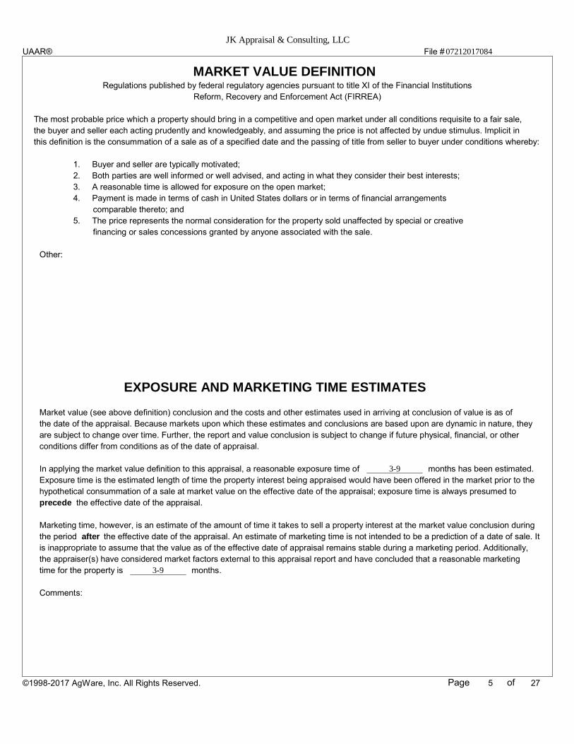
MARKET VALUE DEFINITIONRegulations published by federal regulatory agencies pursuant to title XI of the Financial Institutions
Reform, Recovery and Enforcement Act (FIRREA)
The most probable price which a property should bring in a competitive and open market under all conditions requisite to a fair sale,
the buyer and seller each acting prudently and knowledgeably, and assuming the price is not affected by undue stimulus. Implicit in
this definition is the consummation of a sale as of a specified date and the passing of title from seller to buyer under conditions whereby:
1. Buyer and seller are typically motivated;
2. Both parties are well informed or well advised, and acting in what they consider their best interests;
3. A reasonable time is allowed for exposure on the open market;
4. Payment is made in terms of cash in United States dollars or in terms of financial arrangements
comparable thereto; and
5. The price represents the normal consideration for the property sold unaffected by special or creative
financing or sales concessions granted by anyone associated with the sale.
Other:
EXPOSURE AND MARKETING TIME ESTIMATES
Market value (see above definition) conclusion and the costs and other estimates used in arriving at conclusion of value is as of
the date of the appraisal. Because markets upon which these estimates and conclusions are based upon are dynamic in nature, they
are subject to change over time. Further, the report and value conclusion is subject to change if future physical, financial, or other
conditions differ from conditions as of the date of appraisal.
In applying the market value definition to this appraisal, a reasonable exposure time of months has been estimated.
Exposure time is the estimated length of time the property interest being appraised would have been offered in the market prior to the
hypothetical consummation of a sale at market value on the effective date of the appraisal; exposure time is always presumed to
precede the effective date of the appraisal.
Marketing time, however, is an estimate of the amount of time it takes to sell a property interest at the market value conclusion during
the period after the effective date of the appraisal. An estimate of marketing time is not intended to be a prediction of a date of sale. It
is inappropriate to assume that the value as of the effective date of appraisal remains stable during a marketing period. Additionally,
the appraiser(s) have considered market factors external to this appraisal report and have concluded that a reasonable marketing
time for the property is months.
Comments:
Page of
JK Appraisal & Consulting, LLC07212017084
3-9
3-9
5 27
UAAR®
©1998-2017 AgWare, Inc. All Rights Reserved.
File #
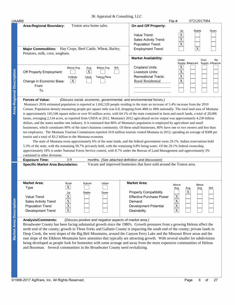
Area-Regional Boundary: On and Off Property:
Up Stable Down
Value Trend:
Sales Activity Trend:
Population Trend:
Major Commodities: Employment Trend:
Market Availability:Under Over NoSupply Balanced Supply Influence
Above Avg. Avg. Below Avg. N/A Cropland Units:
Off Property Employment: Livestock Units:
Unlikely Likely Taking Place Recreational Tracts:
Change in Economic Base:
From
To
Forces of Value: (Discuss social, economic, governmental, and environmental forces.)
Are
a-R
eg
ion
al
De
sc
rip
tio
n
Exposure Time: months. (See attached definition and discussion)
Specific Market Area Boundaries:
Market Area: Rural Suburb Urban Market Area:Above Below
Type Avg. Avg. Avg. N/A
Up Stable Down Property Compatibility
Value Trend Effective Purchase Power
Sales Activity Trend Demand
Population Trend Development Potential
Development Trend Desirability
Analysis/Comments: (Discuss positive and negative aspects of market area.)
Ma
rke
t A
rea
De
sc
rip
tio
n
Page of
JK Appraisal & Consulting, LLC07212017084
Toston area home sales.
Hay Crops, Beef Cattle, Wheat, Barley,Potatoes, milk, corn, sorghum.
X
X
XXX
X
XXX
Rural Residential X
Montana's 2016 estimated population is reported at 1,042,520 people residing in the state an increase of 5.4% increase from the 2010
Census. Population density measuring people per square mile was 6.8, dropping from 48th to 49th nationally. The total land area of Montana
is approximately 145,546 square miles or over 93 million acres, with 64.1% of the state contained in farm and ranch lands, a total of 28,006
farms, averaging 2,134 acres, as reported from USDA in 2012. Montana's 2012 agricultural sector output was approximately 4.230 billion
dollars, and the states number one industry. It is estimated that 80% of Montana's population is employed by agriculture and small
businesses, which constitutes 90% of the state's business community. Of these small businesses, 80% have one or two owners and less than
ten employees. The Montana Tourism Commission reported 10.8 million tourists visited Montana in 2012, spending an average of $308 per
tourist and a total of $3.2 billion to the Montana economy.
The state of Montana owns approximately 6% of the state lands, and the federal government owns 29.1%. Indian reservations hold
5.3% of the state, with the remaining 58.7% privately held, with the remaining 0.8% being water. Of the 29.1% federal ownership,
approximately 18% is under National Forest Service control, with 8.7% under the Bureau of Land Management and approximately 3%
contained in other divisions.
3-9Vacant and improved homesites that have sold around the Toston area.
X
XXXX
XXXXX
Broadwater County has been facing substantial growth since the 1980's. Growth pressures from a growing Helena affect thenorth end of the county; growth in Three Forks and Gallatin County is impacting the south end of the county; private lands inDeep Creek, the west slopes of the Big Belt Mountains, around the Canyon Ferry Lake and the Missouri River areas and theeast slope of the Elkhorn Mountains have amenities that typically are attracting growth. With several smaller lot subdivisionsbeing developed as people look for homesites with some acreage and away from the more expensive communities of Helenaand Bozeman. Several communities in the Broadwater County need revitalizing.
6 27©1998-2017 AgWare, Inc. All Rights Reserved.
UAAR®

File #
Page of
JK Appraisal & Consulting, LLC07212017084
Location Map
SUBJECT
NO
RT
H
7 27
UAAR®
©1998-2017 AgWare, Inc. All Rights Reserved.

File #
Page of
JK Appraisal & Consulting, LLC07212017084
Area and Regional Data
COMMUNITY AND ECONOMIC FEATURES
BROADWATER COUNTY
Location
Broadwater County is located in southwest Montana. It is bordered on the north by Lewis and Clark County, on the east by Meagher County, on
the south by Gallatin County, and on the west by Jefferson County. The County includes 1,239 square miles, of which, 1,191 is in the form of
land and 48 square miles are water. The county is mountainous with the valley area used for agriculture. Elevations range from 9,472 feet on
the top of Mount Baldy to the average valley elevation of 3800 feet. The Big Belt Mountains run along the eastern border, and the Elkhorn
Mountains form the western boundary. The Missouri River flows through the county from south to north, offering both irrigation for crops and
recreational opportunities. Canyon Ferry Lake covers approximately 35,000 acres in the northern part of the county, is the third largest lake in
the state, and the lake shore is federally owned. Canyon Ferry Lake is Broadwater County's major asset, for its power generation, crop irrigation,
and recreational capabilities.
Broadwater County's 796,000 acres, the land usage is as follows:
Private Lands 65% 515,000 acres
Grazing 41% 326,000 ac
Dry Crop 10% 77,000 ac
Irrigated 8% 46,000 ac
Timber - private 4% 35,000 ac
Other - urban, utilities 2% 20,000 ac
State Lands 3% 24,500 acres
Federal Lands 32% 257,500 acres
Broadwater County located between the major cities of Helena and Bozeman, with potential markets for Broadwater County goods and services.
The county is also located on the route between Bozeman and Helena, which offers potential for travel and tourist commerce, not to mention the
County's amenities for recreational activities.
Water Sources
Broadwater County is fortunate to have abundant water resources, by Montana standards, which makes irrigated crop land a major factor
in the county's agricultural economy. Water is obtained from both surface water diversions and from groundwater development.
The Missouri River, which flows south to north through the county, is the key surface water source. Toston Dam on the Missouri,
located approximately four miles south of the community of Toston, provides water for the Broadwater Missouri Diversion Project. This project
furnishes water to irrigate crop lands along both sides of the river through two canals. The west side canal is 15 miles in length, running
northwest of Toston. The east side canal passes to the east of Townsend, and continues up the east side of Canyon Ferry Lake, ending at Duck
Creek. Total length of the east side canal is 35 miles. Together the two canals irrigate approximately 22,000 acres.
Big Spring Ditch flows out of Big Spring south of Toston, running six miles and ending at Dry Creek. This canal irrigates 2,200 acres.
Another surface water diversion from the Missouri River is the Montana Ditch. Its point of diversion is on the east bank of the river
about two miles south of Townsend. It carries water to the east of Townsend and flows into Canyon Ferry Lake seven miles north of Townsend.
In the 1950's the U.S. Bureau of Reclamation constructed the Canyon Ferry Dam for power generation and irrigation. The resulting
reservoir, Canyon Ferry Lake, has become a major feature of Broadwater County, covering 35,000 acres. Approximately 5,000 acres of
productive agricultural land was inundated by the reservoir. As restitution for the lost prime agricultural acreage, the Bureau of Reclamation
created the Crow Creek Pump Unit, an irrigation development system with a series of canals, ditches and pumps to provide irrigation water to
previously dry crop lands within the valley.
Most of the new water development in the county has been for sprinkler irrigation. In addition, much of the previously flood-irrigated
lands have come under sprinkler irrigation. Sprinkler irrigation systems are more efficient than flood irrigation, thereby making water available
to irrigate additional lands. Sprinkler irrigation can affect ground water levels and quantities, aquifer recharge, and sub-irrigation.
Approximately 46,000 acres of crop land in Broadwater County are currently irrigated. Irrigated lands have and will most likely continue to be
used for hay, pasture, wheat, barley, and potatoes.
8 27
UAAR®
©1998-2017 AgWare, Inc. All Rights Reserved.

File #
Page of
JK Appraisal & Consulting, LLC07212017084
Area and Regional Data
Transportation
The Townsend Airport is located on City- County-owned land, and serves as the base for approximately 12 general aviation single-engine
aircraft, and is used for general aviation, air taxi services, and military use by the National Guard. The airport uses a 4,000' long by 60' asphalt
runway and includes a pilot's lounge, private hangers, and a camping area for overnight stays. The airport stages an annual fly-in on July 4,
bringing in 50-60 aircraft along with pilots and passengers. Recent improvements at the airport include the installation of precision approach
lights and the addition of five hangers since 2000. Two new businesses have also been established - an aircraft repair service and an aircraft sales
business. County's transportation corridors provide access to areas throughout the United States and Canada.
Gallatin Field, 53 miles from Townsend, accommodates five airlines (Delta, Northwest, United, Horizon & Alaska Air) providing a
minimum of six flights per day each, Broadwater County has good air service in comparison to other population centers in Montana.
Connections to major hubs at Salt Lake City, Spokane, and Minneapolis help to support a growing community of business commuters residing in
Broadwater County. The Gallatin Regional Airport is being doubled in size with additional expansion occurring in 2017.
The county road department maintains approximately 670 miles of county roads. The department employs a county road supervisor and
three additional employees. Since the Montana Department of Transportation assumed maintenance responsibilities for secondary state highways
in 1997, the road department has no paved roads to maintain.
Area Prestige
The county has extensive acreage of irrigated crop, hay and pasture lands that contribute significantly to the county economy. Ample water is
available in the county for irrigation and industrial use. The county has extensive timber and agricultural resources, from which value-added
processing can be promoted. The Montana Railink Railroad provides important rail transportation of goods to and from Broadwater County. The
climate is moderate, making the county an appealing and attractive place for visitors, retirees and prospective entrepreneurs. The county
population has been growing steadily, which helps support local businesses and business growth. Many of the incoming new residents favor
strong local economies and communities with appealing environments and life styles. Broadwater County has a growing professional business
sector - finance, insurance, accounting, and health/medical care - that attracts out-of-county customers and strengthens the economy. The county
is close to Helena and Bozeman, major cities with potential markets for Broadwater County goods and services. Also, the county is located on the
route between Bozeman and Helena, which offers potential for travel and tourist commerce.
Broadwater County's lakes, rivers and streams support outstanding fisheries that attract anglers from all over the region. Canyon Ferry Lake and
the Missouri River produces rainbow, brown, brook and cutthroat trout, walleye, whitefish and perch. The resident and non-resident fishing
supports boat dealerships, sporting goods stores, tackle shops and outfitting. The county has abundant wildlife that supports hunting, and
bird/wildlife watching. The Big Belt and Elkhorn Mountains provide excellent mule deer and elk habitat. Whitetail deer thrive along the Missouri
River and in bottomlands. Mountain goats occur in the Big Belts, and a population of antelope range between Townsend and Winston. The
Bureau of Reclamation constructed dust-control ponds and in cooperation with Montana Fish, Wildlife and Parks manages the ponds to produce
excellent habitat for waterfowl and shorebirds. The Canyon Ferry Wildlife Management Area provides outstanding hunting for big game,
pheasants and water fowl, as well as opportunities for watching bird and wildlife. The Indian Creek campground and ponds have been developed
into a very attractive recreation facility that is enjoyed by both local residents and travelers.
The Lewis and Clark expedition up the Missouri river in 1805 provides opportunities for Broadwater County. The expedition traveled up the
Missouri River from the Gates of the Mountains to the three forks of the Missouri River, making significant journal entries, in what is now
Broadwater County. Residents of Broadwater and Gallatin Counties, with state and federal agencies, have developed historical points and features
commemorating the Corps of Discovery.
The Headwaters State Park, across the river from Broadwater County, has become a well-known historical place commemorating the Corps of
Discover. Interpretive signs at Toston Dam explaining the Lewis and Clark expedition are important tourist information attractions. In 2002, local
residents erected a plaque to mark the Crimson Bluffs, a feature southwest of Townsend cited in the Lewis and Clark journals.
9 27
UAAR®
©1998-2017 AgWare, Inc. All Rights Reserved.
File #
Page of
JK Appraisal & Consulting, LLC07212017084
Area and Regional Data
Economic Forces
Broadwater County's economic revenue is healthier than some other counties, due to the type of property taxed or class of taxable valuation.
Under Montana law, utilities have a tax rate of 12%, railroads have a tax base of 4.27%, and residential, commercial, industrial, and agricultural
properties have a tax rate of 3.6% or less. Utilities and railroads are the largest contributors to the county property tax, due largely to a
privately-owned electric power transmission line that crosses Broadwater County from east to west, and the mainline of the Montana RailLink
railroad located in the county. Residential property is the second largest contributor to the property tax base and agriculture is the third.
The economic health of Broadwater County has historically been tied to the area's resources, including agricultural land, timber, and
minerals. The timber resource is at a critical juncture, where decades of fire suppression and drought have combined to create extensive stands of
beetle-killed trees, but market forces have forced sawmills and pulp plants to close. Opportunities exist for economic development based on the
use of woody biomass material removed from forest restoration activities, such as wildfire hazardous fuel treatments, insect and disease
mitigation, forest management due to catastrophic weather events, and/or thinning overstocked stands. Closing of these sawmills and pulp plants
have forced the BCDC to become innovative and purchase equipment to produce a recycled woody biomass pellet, as an alternative energy
source. This alternative energy source, since natural gas available is limited in the area, is hoping to become a cost effective lure for commercial
businesses to come to Broadwater County.
The lands immediately north and west of Townsend are located in the Missouri River floodplain, which also limits the
opportunities for expansion of the community.
Two major mining firms operate in Broadwater County. Apollo Gold Corporation owns the Diamond Hill gold mine in the
Elkhorns north of Townsend. GrayMont Western US, Inc., operates a lime mining and lime processing operation in the Elkhorn Mountains west
of Townsend. Small scale mining operations occur sporadically on public and private land in the
county.
Agriculture
Broadwater County is sustained by agriculture, mining, forestry, and tourism. According to the 2016 Montana State Agricultural
overview, Montana as a whole had 27,400 farms, down from 2012 which had 27,870 farms. Broadwater County, in 2016, had 287 farms, with the
average farm size of 1,661 acres, compared to the state average farm size of 2,179 acres. Broadwater County's total acreage of 796,000 acres,
sixty percent is in agriculture, and eight percent of that is irrigated land. Total farm and ranch assets for Montana were $1.61 Billion with 29.3%
in cropland, 65.9% in rangeland and pasture, 3.3% in woodland and 1.5% in other land resources.
Broadwater County's main commodities of Cattle, Winter and Spring Wheat, Barley, Potatoes, and Forage crops sold, in 2016, had a
market value of 38.1 million dollars. Sixty percent of the commodities sold were crops, while forty percent were livestock commodities.
Broadwater County has abundant water resources for agriculture, compared to other Montana counties. The 2016 Montana State
Agriculture overview shows that over 50% of Broadwater County's cropland was under irrigation and over 70% of the crop yield harvested was
produced from the productivity of irrigation. Total cash receipts from harvested crops, 85% came from irrigated acreage. Irrigated land
constitutes only 8% of the total agricultural acreage, but represents 39% of the taxable valuation of all agricultural acreage. Irrigated lands
generate 28% of the total taxable value of agricultural property.
Recreational and Aesthetic Features
In the 1950's the U.S. Bureau of Reclamation constructed Canyon Ferry Dam just north of Broadwater County for power generation and
irrigation. Hunting, fishing and recreation have a long history in Broadwater County, and the county is developing a strong recreation/travel
industry. The Broadwater Rod and Gun Club, formed in 1902, to influence fish and game management in the area. The Club facilitated planting
of pheasants and trout in the valley. They also planted 36 head of elk up Dry Creek in 1916, which established a successful elk population in the
Big Belt Mountains. In addition to generating electric power and providing irrigation water, Canyon Ferry Lake provides recreation opportunities
of state-wide significance. Lake fishing, ice fishing, boating, camping, and picnicking are major recreation activities associated with the reservoir,
and has contributed to the basic travel and tourism economy of the county. In the 1970's, the U.S. Bureau of Reclamation constructed
dust-control ponds on the south end of the reservoir near Townsend. In cooperation with the Montana Department of Fish, Wildlife and Parks
(FWP), the dust-control ponds are also managed to facilitate waterfowl nesting, which has resulted in excellent, productive habitat for ducks,
geese and many shorebirds. The adjacent FWP Wildlife Management Area complements the waterfowl habitat and provides outstanding hunting
for big game, pheasants and waterfowl, as well as opportunities for watching and photographing wildlife. Canyon Ferry Lake and the Missouri
River have developed a reputation as high quality fisheries. Canyon Ferry Lake, the Missouri River from Three Forks to Townsend, Helena
National Forest, Big Belt Mountains, Elkhorn Mountains, and numerous streams and lakes, and a rich history are amenities that drive a strong
recreation and tourist industry.
10 27
UAAR®
©1998-2017 AgWare, Inc. All Rights Reserved.

File #
Page of
JK Appraisal & Consulting, LLC07212017084
Area and Regional Data
Educational and Cultural Activities
There are three public schools (K-12) available in Townsend and the new high school can now host athletic, academic and arts events for
the students. Helena offers the State of Montana - College of Technology, Carroll College, the University of Montana-Extension, and the
Maddios Hairstyling and Cosmetology College. Bozeman has the Montana State University.
Health Care
The Broadwater County Health Center and Home Health facility is classified as a Small Rural Hospital. The facility has 9 hospital beds and
laboratory and X-ray services. The Health Center provides physical therapy and home health care. The facility includes a nursing home with 35
beds. The staff includes two physicians and a practitioner. The Health Center provides ambulance service in Broadwater County, which includes
an ambulance and 15 emergency medical technicians. Broadwater County owns the physical plant, although the facility is operated
by a private non-profit district board of directors. The facility employs 85 personnel, one of the largest employers in the county.
Climate:
The area climate is continental in nature, and has four distinct seasons. The state of Montana receives from 12 to 24 inches of annual
precipitation, with more than two thirds of that amount expected to fall during the annual growing season. This period extends from early May to
September, with most precipitation falling in the form of scattered afternoon thunderstorms occasionally accompanied by strong winds, lightning
and hail.
Summers are warm and mild, with frequent afternoon thundershowers. The annual frost-free season lasts from 100 to 120 days in this area.
Fall can extend to late October, and winter snows typically begin to fall in November. Several feet of snow can accumulate in the mountainous
areas around the subject from November through February. Annual temperatures commonly vary from 85 degrees to 90 degrees above zero to
minus 40 degrees Fahrenheit; however, such extremes are not typically of a long duration.
Generally, spring weather begins in March, and warm summers extend into September. Falls are cool, with little snow falling until
November or December. Winters are generally cold, with occasional blizzards accompanied by high winds.
Montana lies in the strong belt of westerly's, which move out of the Pacific Ocean and deposit much of their precipitation on the mountain
ranges of the Pacific Northwest and Montana. The average storm track out of the semi-permanent Gulf of Alaska Low is across British Columbia
and eastward across the prairie provinces of Alberta and Saskatchewan. When this weather regime is entrenched firmly over western North
America, Pacific weather systems have already lost a considerable portion of their moisture on the coastal ranges before reaching Montana. The
remaining precipitation is largely confined to the state's mountains.
Over most of Montana June is the wettest month, followed by May, with the exception of some areas of the northwest. The average rainy
season is from May 20th through June 20th. The wettest week of the year is usually the first week of June.
July and August are normally Montana's warmest months, and precipitation usually falls as showers during thunderstorms. A generalized
rain pattern is quite rare. Also, a marked difference exists between the thunderstorms in July and August and those of May and June. The rainy
season thunderstorms are associated with large-scale storm systems well endowed with moisture as well as strong temperature differences. The
resulting heavy rains and hail can cover extensive areas of the state and often move from the east to the west, releasing torrential rains as they lift
over the mountains. As the air masses become warmer and drier in July and August, the convective activity generally moves from the southwest
to the northeast ahead of Pacific systems, with hail tracks tied to the topography of the state. July and August thunderstorms, while more
scattered and often drier, may be destructive, with wind and hail. The higher bases of the clouds create "dry thunderstorms" and their
accompanying vivid lightning, spectacular to viewers.
September in Montana is an obvious transition month and is extremely variable. Hot weather may end abruptly during the end of August or
the first part of September as a major storm sweeps the state. The first snow may fall during the first week of September, and the growing season
often ends with a sharp freeze. The east slopes of the Rockies experience an upsurge of precipitation, a "mini" wet season, which is very
important in the sprouting of winter wheat.
October's normal temperature and precipitation can be rather surprising. October's Indian summer weather is often the most pleasant of the
entire year, and temperatures are usually a little warmer than April. However, a vicious fall snowstorm, much like its cousin the April snowstorm,
can also sweep the state. Some years October has been the driest month of the year.
By November the annual intensification of the Gulf of Alaska Low is underway, and strong southwesterly winds associated with Pacific
weather systems again sweep over the divide onto the plains. Arctic air deepens over northern Canada as the days shorten. The first major arctic
outbreak with below-zero temperatures may reach the plains east of the divide during November, but normally it occurs the first week of
December.
11 27
UAAR®
©1998-2017 AgWare, Inc. All Rights Reserved.

File #
Page of
JK Appraisal & Consulting, LLC07212017084
Area and Regional Data
Montana AgricultureMontana's 60.2 million acres of farms and ranches ranks second in the nation behind Texas in total amount of land in agriculture.The total land area of Montana is approximately 145,388 square miles, with 64.1% of the state contained in farm and ranch lands.The farm population of the state, at 45,718, averages 0.4 people per farm.
Of the approximately 60 million acres in use as farm and ranch lands, 66% is comprised of rangeland, with 30% containingcroplands (8.5 % irrigated). The total number of farms and ranches in the state of Montana has continually decreased since 1933,when there were 53,000 units. As of 2016 it is estimated that there are approximately 27,400 farms and ranches located in the state.The average size of farms and ranches in the state is approximately 2,179 acres. A look at this 2016 agricultural production andinventory rankings shows Montana holds its own among states, according to USDA, National Agricultural Statistics Service,Montana Field Office. Montana ranked second for land in farms with 59.8 million acres in 2016. Texas ranked first with 130.4million acres and Kansas ranked third with 46.2 million acres. Montana ranked thirtieth for number of farms with 27,400, whileTexas ranked first with 247,500 farms. Montana ranked second behind Wyoming for average farm size with 2,068 acres.
Data from NASS March 1, 2016 updated report on Montana: Montana ranked third for all wheat production in 2016, accountingfor 9.2% percent of the U.S. total, surpassed by North Dakota and Kansas. Montana ranked second for durum wheat, fourth forwinter wheat, and second for other spring wheat production, accounting for 30.1 percent, 6.3 percent, and 14.2 percent,respectively, of the nation's total. For durum and spring wheat production, North Dakota ranked first. Kansas ranked first for winterwheat production, followed by Texas, Oklahoma, Washington, and Colorado. Montana accounted for 23.5 percent of the nation'sbarley, ranking third behind North Dakota and Idaho.
Montana ranked second, behind North Dakota, for flaxseed production, accounting for 7.1 percent of the nation's total. Montanaranked first in lentils and dry edible peas. With safflower production, accounting for 13.1 percent of the U.S. total. Montana rankedfifth for sugar beet production with 4.3 percent of the U.S. total, behind Minnesota, North Dakota, and Idaho. Montana ranked thirdfor 2013 for alfalfa hay production with 6.2 percent of the nation's total, behind California and Idaho.
Montana ranked eighth for all sheep and lamb inventory in 2016 with 230,000 head and 4.4 percent of the U.S. total. Montanaranked fifth for breeding sheep inventory with 200,000 head and 5.2 percent of the U.S. total. Montana ranked sixth for lamb cropwith 190,000 head or 5.9 percent of 2016 the U.S. total, preceded by Texas, California, South Dakota, and Wyoming. Montanaranked fifth for wool production with 1.80 million pounds or 7.0 percent of the U.S. total.
Montana's all cattle and calves inventory in 2016, ranked eleventh in the nation with 2.65 million head, or 2.8 percent of the U.S.inventory. Montana ranked ninth for all cows with 1.5 million head, accounting for 3.7 percent of the U.S. total, and seventh forbeef cows with 1.486 million head, accounting for 4.8 percent of the U.S. inventory. Montana ranked eighth for calf crop with 1.47million head, accounting for 4.2 percent of the U.S. total.
Montana beekeepers produced 12.243 million pounds of honey or 7.6 percent of the nation's total in 2016, placing Montana in thirdplace among the states.
12 27
UAAR®
©1998-2017 AgWare, Inc. All Rights Reserved.

File #
(Location, use and physical characteristics)Property Description:
Above BelowSubject Description: Avg. Avg. Avg. N/A
Land Use Deeded Acres Unit Type Unit Size Location
( %) Legal Access
( %) Physical Access
( %) Contiguity
( %) Shape/Ease Mgt.
( %) Adequacy Utilities
( %) Services
( %) Rentability
( %) Compatibility
( %) Market Appeal
( %) FEMA Zone/Date
Total Deeded Acres Total Units ( 100 % ) Building Location
Climatic: " Annual Precipitation ' to ' Elevation Frost-Free Days
Utilities: Water Electric Sewer Gas Telephone
Distance To: Schools Hospital Markets Major Hwy. Service Center
Comments
Page of
JK Appraisal & Consulting, LLC07212017084
The subject property is located approximately two miles west of Toston.
Access is provided by a paved county road to a county gravel road known as Smith Lane. Smith Lane ends at the subject property. The subject
property is part of a larger section of land owned by the State of Montana; with the improvements being owned by the current lessee, Toston Land
Group, LLC. The State of Montana is currently in the process of selling these "cabin sites". I, the appraiser, have been instructed to appraiser the
proposed 9.5 acre site with improvements as if it were available on the open market as a fee simple tract with improvements. The terrain on the
property is undulating with a slight slope towards the Missouri River. The proposed lot does not touch the river but is in close proximity. The
proposed 9.5 acre site with improvements will be completely surrounded by State of Montana public land and make the proposed site an inholding
inside State land with close access to the Missouri River. Improvements are explained in detail on the following page. There is a large set of working
corrals on the site, a house, a shop, a calving barn, a scale house with a certified 20,000 pound scale. There are several other outbuildings that are
older and may have utility but no contributory value.
Rural Homesite 9.50 Acre 100.0
0.0
0.0
0.0
0.0
0.0
0.0
0.0
0.0
0.0
9.50 0.00
X
X
X
X
X
X
X
X
X
X
8/18/2014
12-24 3900 3910 110
Well NW Septic Natural Cnty Link
8 25 8 2 25
There are no hazards or detriments that materially affect the value of the subject property. The subject is susceptible to the area
weather but the surrounding area receives the same type of weather. The weed liability on the property is average for this unit in this area. Should this
be of concern, a weed specialist should be engaged to inspect the weeds during the growing season in order to estimate the expected liability. This
appraisal assumes that the weeds are not toxic and the appraiser reserves the right to update the appraisal should the area found to be hazardous. The
Appraiser is not an expert in either the detection of hazardous or toxic substances or structural engineering, and did not conduct an environmental
audit of the subject property. The property is being appraised assuming there are no toxic or hazardous substances present or associated with the
subject property that would affect value. The Appraiser reserves the right to reassess the situation and adjust values if deemed necessary. A detailed
search was not undertaken to ascertain the exact status of the mineral estate on the subject parcels. As instructed the fee estate is being appraised
subject to any easements, reservations, conveyances, restrictions, and encumbrances of record.
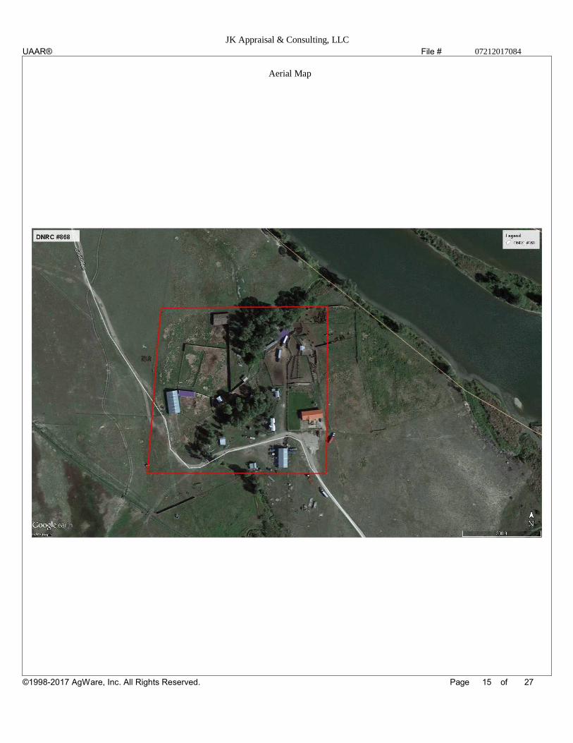
The aerial map presented in this appraisal is not true to the surveyed markers seen during the inspection but is a guess on the appraiser's half as to
where the property lines will be after seeing the survey markers during the inspection.
The area market is extremely limited of sales of similar size. Southern and northern Broadwater County is heavily subdivided due to the pressures of
Helena and Bozeman. The interior of Broadwater County is more agricultural with the majority of the properties being irrigated farm ground and
rangeland. There are some smaller less intensive subdivisions along the Missouri River at Toston but no larger acreages similar to the proposed
subject tract.
13 27©1998-2017 AgWare, Inc. All Rights Reserved.
UAAR®
File #
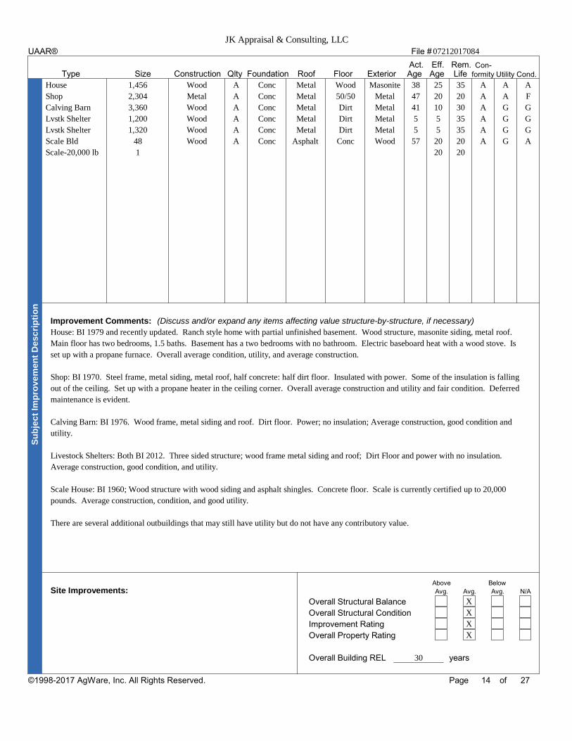
Act. Eff. Rem. Con-Type Size Construction Qlty Foundation Roof Floor Exterior Age Age Life formity Utility Cond.
Improvement Comments: (Discuss and/or expand any items affecting value structure-by-structure, if necessary)
Above BelowSite Improvements: Avg. Avg. Avg. N/A
Overall Structural Balance
Overall Structural Condition
Improvement Rating
Overall Property Rating
Overall Building REL years
Su
bje
ct
Imp
rov
em
en
t D
es
cri
pti
on
Page of
JK Appraisal & Consulting, LLC07212017084
House 1,456 Wood A Conc Metal Wood Masonite 38 25 35 A A A
Shop 2,304 Metal A Conc Metal 50/50 Metal 47 20 20 A A F
Calving Barn 3,360 Wood A Conc Metal Dirt Metal 41 10 30 A G G
Lvstk Shelter 1,200 Wood A Conc Metal Dirt Metal 5 5 35 A G G
Lvstk Shelter 1,320 Wood A Conc Metal Dirt Metal 5 5 35 A G G
Scale Bld 48 Wood A Conc Asphalt Conc Wood 57 20 20 A G A
Scale-20,000 lb 1 20 20
House: BI 1979 and recently updated. Ranch style home with partial unfinished basement. Wood structure, masonite siding, metal roof.
Main floor has two bedrooms, 1.5 baths. Basement has a two bedrooms with no bathroom. Electric baseboard heat with a wood stove. Is
set up with a propane furnace. Overall average condition, utility, and average construction.
Shop: BI 1970. Steel frame, metal siding, metal roof, half concrete: half dirt floor. Insulated with power. Some of the insulation is falling
out of the ceiling. Set up with a propane heater in the ceiling corner. Overall average construction and utility and fair condition. Deferred
maintenance is evident.
Calving Barn: BI 1976. Wood frame, metal siding and roof. Dirt floor. Power; no insulation; Average construction, good condition and
utility.
Livestock Shelters: Both BI 2012. Three sided structure; wood frame metal siding and roof; Dirt Floor and power with no insulation.
Average construction, good condition, and utility.
Scale House: BI 1960; Wood structure with wood siding and asphalt shingles. Concrete floor. Scale is currently certified up to 20,000
pounds. Average construction, condition, and good utility.
There are several additional outbuildings that may still have utility but do not have any contributory value.
X
X
X
X
30
14 27
UAAR®
©1998-2017 AgWare, Inc. All Rights Reserved.
File #
Page of
JK Appraisal & Consulting, LLC07212017084
Aerial Map
15 27
UAAR®
©1998-2017 AgWare, Inc. All Rights Reserved.

File #
Page of
JK Appraisal & Consulting, LLC07212017084
Front of House South side of shop
Scale House and Scale Livestock Shed
Corrals Livestock Shed across corrals
16 27©1998-2017 AgWare, Inc. All Rights Reserved.
UAAR®

File #
Page of
JK Appraisal & Consulting, LLC07212017084
Saddle shed; NO CV Original homestead cabin; No CV
Inside shop North side of shop and two 500 Gallon fuel tanks
Older fuel tank; still functioning but not used. Older storage shed; No CV
17 27©1998-2017 AgWare, Inc. All Rights Reserved.
UAAR®
File #
Page of
JK Appraisal & Consulting, LLC07212017084
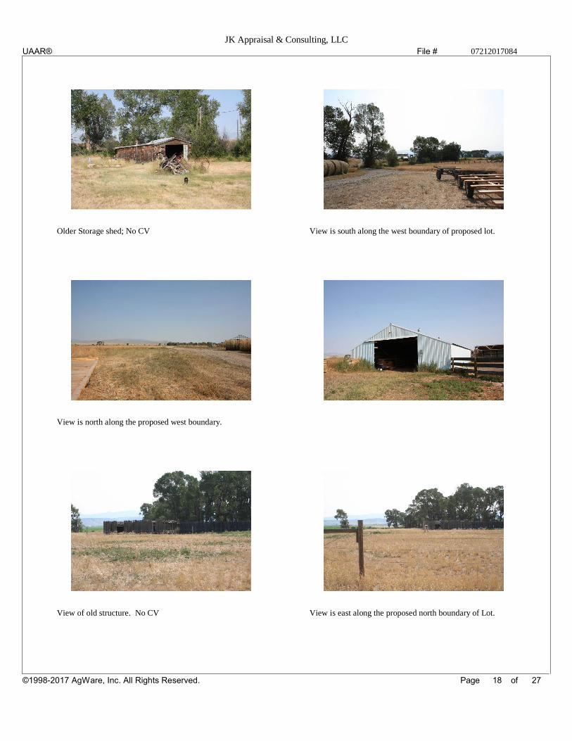
Older Storage shed; No CV View is south along the west boundary of proposed lot.
View is north along the proposed west boundary.
View of old structure. No CV View is east along the proposed north boundary of Lot.
18 27©1998-2017 AgWare, Inc. All Rights Reserved.
UAAR®
File #
Ownership Longer Than Years
Owner Recording/Reference Date Price Paid Terms
Previous: $
Present: $
Currently: Optioned Under Contract Contract Price: $
Buyer: Currently Listed Listing Price: $ Listing Date:
His
tory
Current Zoning: Zoning Conformity: Yes No
Zoning Change: Unlikely Probable To:
Comments:
Zo
nin
g
Tax Basis: Assessment Year Forecast:
Agricultural Land $ Current Tax $
Building(s) $ Estimated/Stabilized $
$ Or ( Ac.) =$ /acre
Parcel #: Total Assessed Value $
Trend: Up Down Stable
Comments:
Ta
xe
s
Highest & Best Use is defined as that reasonable and probable use that supports the highest present value, as defined, as of the effective date of the appraisal. Alternatively, that use, from among
reasonably probable and legally alternative uses, found to be physically possible, appropriately supported, financially feasible, and which results in the highest land value.
Analysis: (Discuss legally permissible, physically possible, financially feasible, and maximally productive uses)
Highest and Best Use: "As if" Vacant
"As Improved"
Discussion:
Hig
he
st
& B
es
t U
se
An
aly
sis
Valuation Methods: Cost Approach Income Approach Sales Comparison Approach
(Explain and support exclusion of one or more approaches)
Va
lue
Me
tho
ds
Page of
JK Appraisal & Consulting, LLC07212017084
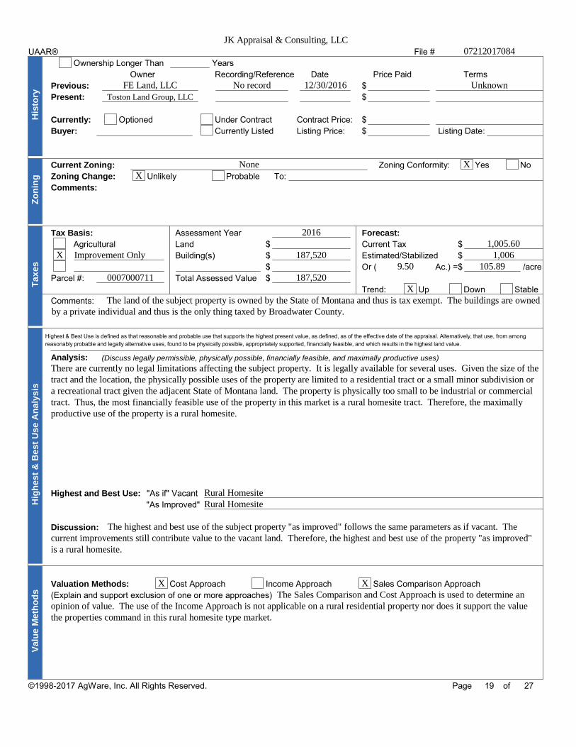
FE Land, LLC No record 12/30/2016 UnknownToston Land Group, LLC
None XX
X Improvement Only
0007000711
2016
187,520
187,520
1,005.601,006
9.50 105.89
XThe land of the subject property is owned by the State of Montana and thus is tax exempt. The buildings are owned
by a private individual and thus is the only thing taxed by Broadwater County.
There are currently no legal limitations affecting the subject property. It is legally available for several uses. Given the size of thetract and the location, the physically possible uses of the property are limited to a residential tract or a small minor subdivision ora recreational tract given the adjacent State of Montana land. The property is physically too small to be industrial or commercialtract. Thus, the most financially feasible use of the property in this market is a rural homesite tract. Therefore, the maximallyproductive use of the property is a rural homesite.
Rural HomesiteRural Homesite
The highest and best use of the subject property "as improved" follows the same parameters as if vacant. Thecurrent improvements still contribute value to the vacant land. Therefore, the highest and best use of the property "as improved"is a rural homesite.
X XThe Sales Comparison and Cost Approach is used to determine an
opinion of value. The use of the Income Approach is not applicable on a rural residential property nor does it support the valuethe properties command in this rural homesite type market.
19 27©1998-2017 AgWare, Inc. All Rights Reserved.
UAAR®

File #
Cost Approach
Subject Land Contribution
Primary Site Excess Land TotalAcres $/Acre Site Contrib Acres $/Acre Excess Contrib Acres $/Acre Total Contrib
$ $ $ $ $ $
Reproduction Cost is the estimated cost to construct, at current prices as of the effective appraisal date, an exact or duplicate or
replica of the structure appraised, using the same materials, construction standards, design, layout, and quality of workmanship, and
embodying all of the deficiencies, superadequacies, and obsolescence of the subject buildings.
Replacement Cost is the estimated cost to construct, at current prices as of the effective appraisal date, a building with utility
equivalent to the buildings appraised, using modern and current standards, design, and layout.
Site Improvements Cost Analysis
Site Improvements Comments: Site Improvements Cost Effective Years % DeprecDescription New Age REL Depr Cost
$ % $
$ % $
$ % $
$ % $
$ % $
$ % $
$ % $
Total Contribution of Site Improvements $
Structural Improvements Cost Analysis
Unit Total Act Age Total Life Depreciation/Obsolescence DeprecCost/Unit
Description Size Cost New Eff Age REL % Phys % Fnct % Ext Cost$ $ % % % $
$ $ % % % $
$ $ % % % $
$ $ % % % $
$ $ % % % $
$ $ % % % $
$ $ % % % $
$ $ % % % $
$ $ % % % $
$ $ % % % $
Totals $ % % %Total Overall Depreciation % Total Contribution of Structural Improvements $
Cost Approach Summary
Contribution % of Total
$Total Land $Site Improvements Cost Approach Indication: $Structural Improvements $ $
Page of
JK Appraisal & Consulting, LLC
07212017084
9.50 3,500.00 33,250 9.50 3,500.00 33,250
X
There are no underground
sprinklers; the well and septic are included in the contributory value
of the improvements.
X
House 1,456 165.00 240,240 25 35 42 139,339
Shop 2,304 25.00 57,600 20 20 50 28,800
Calving Barn 3,360 18.00 60,480 10 30 25 45,360
Lvstk Shelter 1,200 8.00 9,600 5 35 13 8,352
Lvstk Shelter 1,320 8.00 10,560 5 35 13 9,187
Scale Bld 48 12.00 576 20 20 50 288
Scale-20,000 lb 1 32,600.00 32,600 20 20 50 16,300
411,656 31 40 0 0
40 247,626
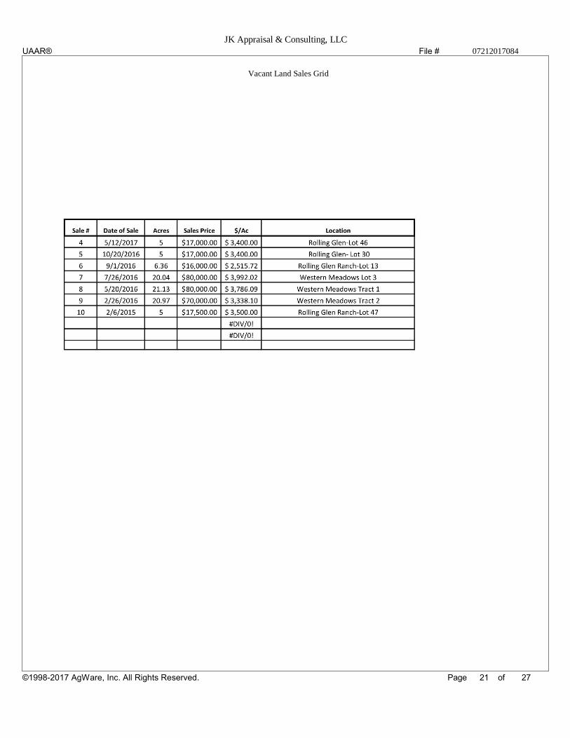
As mentioned, there is very limited data in the immediate area of the subject property. The area is heavily influenced by agricultural with more
subdivisions closer to Helena and Bozeman. The three comparables sales used in this appraisal are felt to most comparable to the subject property. Sale
1 is located south of the subject and is located in a developed/platted subdivision. Sale 1 indicates a vacant per acre price of $3,300/acre. Sale 2 is
located north of the subject property and is larger then the subject and indicates a vacant land price of $3,500 per acre. Sale 4 is a lot inside a smaller
acreage subdivision south and east of Toston and along the Missouri River. Sale 3 does not have frontage on the river but does have access to the river.
Sale 3 is also based on a "site value" and indicates a site value for the vacant lot of $12,200 per site. Sale 3 was included in the data set because it was one
of the few more recent sales found in the market. The appraiser also found seven vacant land sales located south of the subject property in the Rolling
Glen and Western Meadows subdivisions. The seven sales range in size from 5 to 21 acres and sold between February 2015 and May 2017 with five of
the seven sales occurring in 2016. The sales have a range of sold price per acre from $2,515/ac (Sale 6) to $3,786 per acre. Once Sale 6 is removed from
the data set, the range tightens to $3,338 to $3,786 per acre and appears to remain consistent with no time adjustment evident. These seven vacant land
sales give additional support for the concluded vacant land price on the subject property and can been seen in spreadsheet format on the following page.
The contributory value of the buildings found on the subject property are based off of agricultural sales found in the market and from the appraiser's
database that support the indicated RCN of the structures; as well as the market supported depreciation of the improvements. Thus, the improvements
have a contributory value of $247,626.
33,250 12
247,626 88
280,800
20 27
UAAR®
©1998-2017 AgWare, Inc. All Rights Reserved.
File #
Page of
JK Appraisal & Consulting, LLC07212017084
Vacant Land Sales Grid
21 27
UAAR®
©1998-2017 AgWare, Inc. All Rights Reserved.

File #
Page of
JK Appraisal & Consulting, LLC07212017084
Vacant Sales Map
22 27
UAAR®
©1998-2017 AgWare, Inc. All Rights Reserved.

File #
Sales Comparison ApproachSubject Sale +/- Adj Sale +/- Adj Sale +/- Adj
Sale #Time Adj SettingGrantor
GranteeYear
Address Month
Sale PriceSimpleCEV PriceCompoundDate
Adj to Date Periods Rate Periods Rate Periods RateMarket Condition
Land Adjustments
Homesite Acres
Excess Acres
Excess +/- Acres $/Acre +/- Acres $/Acre +/- Acres $/Acre
Difference
Legal Access
Physical Access
Primary Improvement Adjustment
Effective Age
Contrib/Eff Size
Design & Appeal
Qlty of Constr
Rooms Total Bdrms Baths Total Bdrms Baths Total Bdrms Baths Total Bdrms Baths
Above Grade
Basement
Finished Bsmt
Utility
Condition
Heating/Cooling
Energy Eff Items
Garage/Carport
Porch, Patio, Dk
Fireplace(s), etc
Additional Adjustments
Other Impvts
Location
Utilities
View
Summary
CEV Price
Total Net Adj
Adj CEV Price
Sales Comparison Indication:
$
Page of
JK Appraisal & Consulting, LLC07212017084
X
X
9.50
Paved to two track
25
1456
Ranch Style
A
7 2 1.00
Yes
No
A
A
Electric/Wood
Solar Panels
1 car Detached
Deck
Yes
Several Ag Outbuilding
W of Toston
Yes
Good
River Frontage Close but no frontage
1
Confidential
Confidential
37 Wheatland Meadows Dr
Three Forks, MT
536,500
536,500
07/17
0
6.34
0.00
0 0
Cnty Gravel
Yes
3
3111 -250,000
Ranch Style
New
7 5 3
Yes
1353 Finished
New
New
FA-Propane
4+ Attached -75,000
Deck
Yes
+79,787
N of Three Forks
Yes
Good
No
536,500
-245,213
291,287
2
Confidential
Confidential
4 Wild Horse Lane
Townsend, MT
545,000
545,000
04/17
0
20.98 -35,000
0.00
0
Cnty gravel rd
Yes
12
3598 SF -300,000
1.5 Story
A
10 5 4
No
N/A
Avg
Avg
Radiant
Natural Gas
2 Detached -25,000
Deck; Porch
Yes
+108,287
SE of Townsend
Yes
Average
Creek -10,000
545,000
-261,713
283,287
3
Confidential
Confidential
48 Missouri View Loop
Toston, MT
280,000
280,000
09/16
0
1.38
0.00
0 +35,000
Cnty Gravel
Yes
15
2164 SF -95,000
Ranch Style
A
8 3 2
No
N/A
Avg
Avg
FA-Propane
Propane
3 Attached -50,000
Deck/Porch
Yes
+108,287
SE of Toston
Yes
Average
No
280,000
-1,713
278,287
The size adjustment is based on the difference between the size of the subject and the comparable sales and the current building price based on a square
foot. The adjustment made for the difference in garage size is based on the construction cost of a garage. The other improvements adjustment is the
addition of the subject's additional outbuildings. Sales 1 is slightly superior to the subject property while Sale 2 is slightly superior. Sale 3 is slightly
inferior. Sale 2 is the best indicator of value and supports the conclude opinion of value of $280,000 for the subject property with additional support
from Sale 3. As stated, the market is very limited for similar comparables. Many of the subdivision sells in the
area are smaller like Sale 3.280,000
23 27©1998-2017 AgWare, Inc. All Rights Reserved.
UAAR®
G=75% N=-46% G=88% G=103% N=-48% N=-1%
File #File #
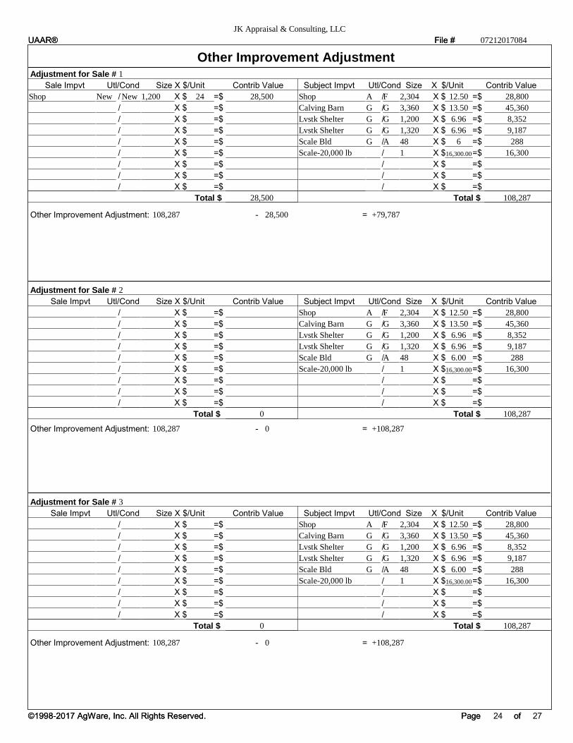
Other Improvement AdjustmentAdjustment for Sale #
Sale Impvt Utl/Cond Size X $/Unit Contrib Value Subject Impvt Utl/Cond Size X $/Unit Contrib Value
/ X $ =$ / X $ =$
/ X $ =$ / X $ =$
/ X $ =$ / X $ =$
/ X $ =$ / X $ =$
/ X $ =$ / X $ =$
/ X $ =$ / X $ =$
/ X $ =$ / X $ =$
/ X $ =$ / X $ =$
/ X $ =$ / X $ =$
Total $ Total $
Other Improvement Adjustment: - =
Adjustment for Sale #
Sale Impvt Utl/Cond Size X $/Unit Contrib Value Subject Impvt Utl/Cond Size X $/Unit Contrib Value
/ X $ =$ / X $ =$
/ X $ =$ / X $ =$
/ X $ =$ / X $ =$
/ X $ =$ / X $ =$
/ X $ =$ / X $ =$
/ X $ =$ / X $ =$
/ X $ =$ / X $ =$
/ X $ =$ / X $ =$
/ X $ =$ / X $ =$
Total $ Total $
Other Improvement Adjustment: - =
PagePage ofof
JK Appraisal & Consulting, LLC
07212017084
1
Shop New New 1,200 24 28,500
28,500
Shop A F 2,304 12.50 28,800
Calving Barn G G 3,360 13.50 45,360
Lvstk Shelter G G 1,200 6.96 8,352
Lvstk Shelter G G 1,320 6.96 9,187
Scale Bld G A 48 6 288
Scale-20,000 lb 1 16,300.00 16,300
108,287
108,287 28,500 +79,787
2
0
Shop A F 2,304 12.50 28,800
Calving Barn G G 3,360 13.50 45,360
Lvstk Shelter G G 1,200 6.96 8,352
Lvstk Shelter G G 1,320 6.96 9,187
Scale Bld G A 48 6.00 288
Scale-20,000 lb 1 16,300.00 16,300
108,287
108,287 0 +108,287
3
0
Shop A F 2,304 12.50 28,800
Calving Barn G G 3,360 13.50 45,360
Lvstk Shelter G G 1,200 6.96 8,352
Lvstk Shelter G G 1,320 6.96 9,187
Scale Bld G A 48 6.00 288
Scale-20,000 lb 1 16,300.00 16,300
108,287
108,287 0 +108,287
24 27©1998-2017 AgWare, Inc. All Rights Reserved.
UAAR®
©1998-2017 AgWare, Inc. All Rights Reserved.
UAAR®
File #
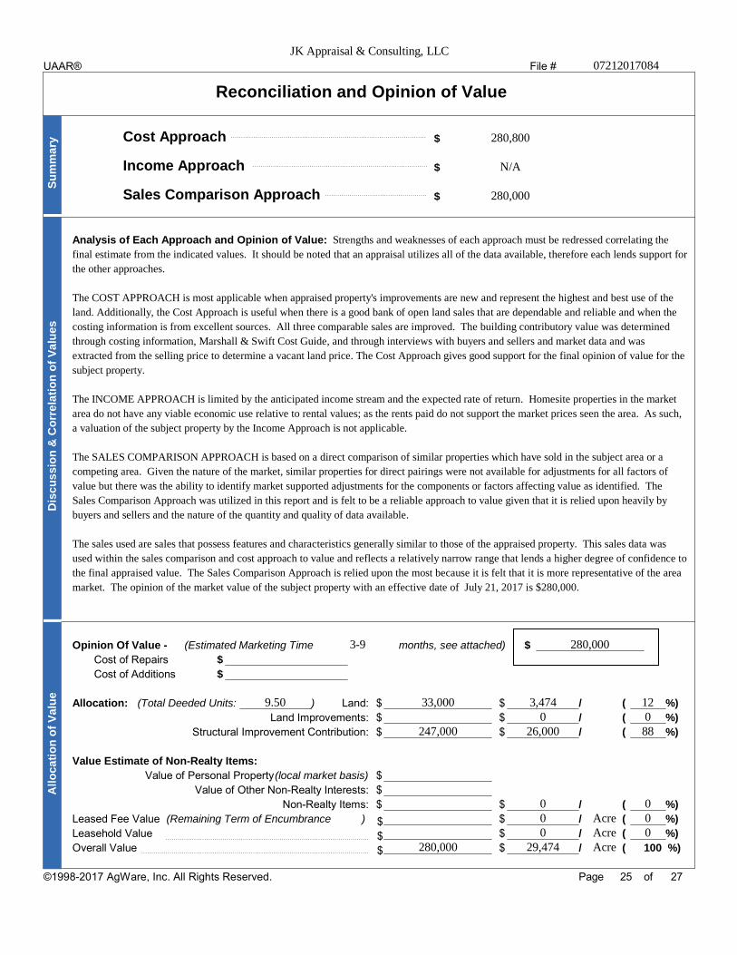
Reconciliation and Opinion of Value
Cost Approach $
Income Approach $
Sales Comparison Approach $
Su
mm
ary
Analysis of Each Approach and Opinion of Value:
Dis
cu
ss
ion
& C
orr
ela
tio
n o
f V
alu
es
Opinion Of Value - (Estimated Marketing Time months, see attached) $
Cost of Repairs $
Cost of Additions $
Allocation: (Total Deeded Units: ) Land: $ $ / ( %)
Land Improvements: $ $ / ( %)
Structural Improvement Contribution: $ $ / ( %)
Value Estimate of Non-Realty Items:
Value of Personal Property(local market basis) $
Value of Other Non-Realty Interests: $
Non-Realty Items: $ $ / ( %)
Leased Fee Value (Remaining Term of Encumbrance ) $ / ( %)$Leasehold Value $ / ( %)$Overall Value $ / ( 100 %)$
All
oc
ati
on
of
Va
lue
Page of
JK Appraisal & Consulting, LLC07212017084
280,800
N/A
280,000
Strengths and weaknesses of each approach must be redressed correlating the
final estimate from the indicated values. It should be noted that an appraisal utilizes all of the data available, therefore each lends support for
the other approaches.
The COST APPROACH is most applicable when appraised property's improvements are new and represent the highest and best use of the
land. Additionally, the Cost Approach is useful when there is a good bank of open land sales that are dependable and reliable and when the
costing information is from excellent sources. All three comparable sales are improved. The building contributory value was determined
through costing information, Marshall & Swift Cost Guide, and through interviews with buyers and sellers and market data and was
extracted from the selling price to determine a vacant land price. The Cost Approach gives good support for the final opinion of value for the
subject property.
The INCOME APPROACH is limited by the anticipated income stream and the expected rate of return. Homesite properties in the market
area do not have any viable economic use relative to rental values; as the rents paid do not support the market prices seen the area. As such,
a valuation of the subject property by the Income Approach is not applicable.
The SALES COMPARISON APPROACH is based on a direct comparison of similar properties which have sold in the subject area or a
competing area. Given the nature of the market, similar properties for direct pairings were not available for adjustments for all factors of
value but there was the ability to identify market supported adjustments for the components or factors affecting value as identified. The
Sales Comparison Approach was utilized in this report and is felt to be a reliable approach to value given that it is relied upon heavily by
buyers and sellers and the nature of the quantity and quality of data available.
The sales used are sales that possess features and characteristics generally similar to those of the appraised property. This sales data was
used within the sales comparison and cost approach to value and reflects a relatively narrow range that lends a higher degree of confidence to
the final appraised value. The Sales Comparison Approach is relied upon the most because it is felt that it is more representative of the area
market. The opinion of the market value of the subject property with an effective date of July 21, 2017 is $280,000.
3-9 280,000
9.50 33,000 3,474 120 0
247,000 26,000 88
0 00 Acre 00 Acre 0
280,000 29,474 Acre
25 27©1998-2017 AgWare, Inc. All Rights Reserved.
UAAR®

File #
Assumptions and Limiting Conditions
The certification of the Appraiser(s) appearing in the appraisal report is subject to the following conditions and to such other specific and limiting conditions as are setforth in the report.
1. The Appraiser(s) assume no responsibility for matters of a legal nature affecting the property appraised or the title thereto, nor does the Appraiser(s) render anyopinion as to title, which is assumed to be good and marketable. The property is appraised as though under responsible ownership.
2. Sketches in the report may show approximate dimensions and are included only to assist the reader in visualizing the property. The Appraiser(s) have made nosurvey of the property. Drawings and/or plats are not represented as an engineer's work product, nor are they provided for legal reference.
3. The Appraiser(s) are not required to give testimony or appear in court because of having made the appraisal with reference to the property in question, unlessarrangements have been previously made.
4. Any distribution of the valuation in the report applies only under the existing program of utilization. The separate valuations of components must not be usedoutside of this appraisal and are invalid if so used.
5. The Appraiser(s) have, in the process of exercising due diligence, requested, reviewed, and considered information provided by the ownership of the propertyand client, and the Appraiser(s) have relied on such information and assumes there are no hidden or unapparent conditions of the property, subsoil, orstructures, which would render it more or less valuable. The Appraiser(s) assume no responsibility for such conditions, for engineering which might be requiredto discover such factors, or the cost of discovery or correction.
6. While the Appraiser(s) have have not inspected the subject property and have have not considered the information developed in the course of such inspection, together with the information provided by the ownership and client, the Appraiser(s) are not qualified to verify or detect the presence of hazardous substances by visual inspection or otherwise, nor qualified to determine the effect, if any, of known or unknown substances present. Unless otherwisestated, the final value conclusion is based on the subject property being free of hazardous waste contaminations, and it is specifically assumed that present andsubsequent ownerships will exercise due diligence to ensure that the property does not become otherwise contaminated.
7. Information, estimates, and opinions furnished to the Appraiser(s), and contained in the report, were obtained from sources considered reliable and believed tobe true and correct. However, no responsibility for accuracy of such items furnished the Appraiser(s) can be assumed by the Appraiser(s).
8. Unless specifically cited, no value has been allocated to mineral rights or deposits.
9. Water requirements and information provided has been relied on and, unless otherwise stated, it is assumed that:
a. All water rights to the property have been secured or perfected, that there are no adverse easements or encumbrances, and the propertycomplies with Bureau of Reclamation or other state and federal agencies;
b. Irrigation and domestic water and drainage system components, including distribution equipment and piping, are real estate fixtures;c. Any mobile surface piping or equipment essential for water distribution, recovery, or drainage is secured with the title to real estate; andd. Title to all such property conveys with the land.
10. Disclosure of the contents of this report is governed by applicable law and/or by the Bylaws and Regulations of the professional appraisal organization(s)with which the Appraiser(s) are affiliated.
11. Neither all nor any part of the report, or copy thereof, shall be used for any purposes by anyone but the client specified in the report without the writtenconsent of the Appraiser.
12. Where the appraisal conclusions are subject to satisfactory completion, repairs, or alterations, the appraisal report and value conclusion are contingentupon completion of the improvements in a workmanlike manner consistent with the plans, specifications and/or scope of work relied upon in the appraisal.
13. Acreage of land types and measurements of improvements are based on physical inspection of the subject property unless otherwise noted in this appraisal report.
14. EXCLUSIONS. The Appraiser(s) considered and used the three independent approaches to value (cost, income, and sales comparison) where applicable in valuingthe resources of the subject property for determining a final value conclusion. Explanation for the exclusion of any of the three independent approaches to value indetermining a final value conclusion has been disclosed in this report.
15. SCOPE OF WORK RULE. The scope of work was developed based on information from the client. This appraisal and report was prepared for the client, at theirsole discretion, within the framework of the intended use. The use of the appraisal and report for any other purpose, or use by any party not identified as anintended user, is beyond the scope of work contemplated in the appraisal, and does not create an obligation for the Appraiser.
16. Acceptance of the report by the client constitutes acceptance of all assumptions and limiting conditions contained in the report.
17. Other Contingent and Limiting Conditions:
Page of
JK Appraisal & Consulting, LLC07212017084
X X
26 27©1998-2017 AgWare, Inc. All Rights Reserved.
UAAR®

File #
Appraiser CertificationI certify that, to the best of my knowledge and belief:
1. the statements of fact contained in this report are true and correct.
2. the reported analyses, opinions, and conclusions are limited only by the reported assumptions and limiting conditions,
and are my personal, impartial and unbiased professional analysis, opinions, and conclusions.
3. I have no the specified present or prospective interest in the property that is the subject of this report and
I have no the specified personal interest with respect to the parties involved.
4. I have performed no the specified services, as an appraiser or in any other capacity, regarding the property
that is the subject of this report within the three-year period immediately preceding acceptance of this assignment.
5. I have no bias with respect to the property that is the subject of this report or to the parties involved with this assignment.
6. my engagement in this assignment was not contingent upon developing or reporting predetermined results.
7. my compensation for completing this assignment is not contingent upon the development or reporting of a predetermined
value or direction in value that favors the cause of the client, the amount of the value opinion, the attainment of a stipulated
result, or the occurrence of a subsequent event directly related to the intended use of this appraisal.
8. my analyses, opinions, and conclusions were developed, and this report has been prepared, in conformity with the
Uniform Standards of Professional Appraisal Practice.
9. I have have not made a personal inspection of the property that is the subject of this report.
10. no one the specified persons provided significant real property appraisal assistance to the person signing this
certification.
Effective Date of Appraisal: $Opinion of Value:
Appraiser:
Property Inspection: Yes NoSignature:Inspection Date:
Name:Appraiser has inspected verified analyzedLicense #:the sales contained herein.Certification #:
Date Signed:
Page of
JK Appraisal & Consulting, LLC07212017084
X
X
X
X
X
11. Mrs. Rickett is a General Certified Real Estate Appraiser, Montana Certificate #REA-RAG-LIC-650.
July 21, 2017 280,000
Katie Rickett, A.R.A.
MT Certified General REA-RAG-LIC-650
ASFMRA ASFMRA Member # 1664
August 10, 2017
X
July 21, 2017
X X X
27 27
UAAR®
©1998-2017 AgWare, Inc. All Rights Reserved.

ADDENDA
Exhibit 1 – Sales
Exhibit 2 – DNRC Engagement Letter
Exhibit 3 – Warranty Deeds
Exhibit 4 – FEMA Map; Water Rights
Exhibit 5 – Qualifications of Appraiser

EXHIBIT 1
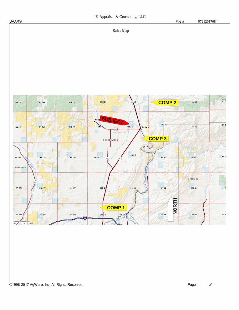
File #
Page of
JK Appraisal & Consulting, LLC07212017084
Sales Map
SUBJECT
COMP 3
COMP 2
COMP 1
NO
RT
H
UAAR®
©1998-2017 AgWare, Inc. All Rights Reserved.
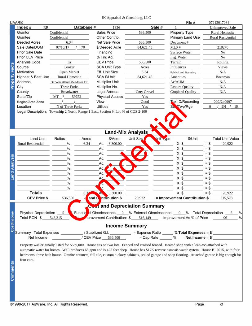
File #
Index # Database # Sale #Grantor Sales Price Property Type
Grantee Other Contrib. Primary Land Use
Deeded Acres Net Sale Price
Sale Date/DOM / $/Deeded Acre
Prior Sale Date Financing
Prior CEV Price % Fin. Adj.
Analysis Code CEV Price
Source SCA Unit Type
Motivation Eff. Unit Size
Highest & Best Use SCA $/Unit
Address Multiplier Unit
City Multiplier No.
County Legal Access
State/Zip / Physical Access
Region/Area/Zone / / View Tax ID/Recording
Location Utilities Sec/Twp/Rge / /
Legal Description:
Pro
pe
rty
Fa
cts
Land-Mix AnalysisLand Use Ratios Acres $/Acre Unit Size Unit Type $/Unit Total Unit Value
% Ac. X $ = $
% Ac. X $ = $
% Ac. X $ = $
% Ac. X $ = $
% Ac. X $ = $
% Ac. X $ = $
% Ac. X $ = $
% Ac. X $ = $
% Ac. X $ = $
% Ac. X $ = $
Totals Ac. X $ = $
La
nd
An
aly
sis
CEV Price $ - Land Contribution $ = Improvement Contribution $
Cost and Depreciation Summary
Physical Depreciation % Functional Obsolescence % External Obsolescence % Total Depreciation %
Total RCN $ Total Improvement Contribution: $ Improvement As % of Price %
Income Summary
Summary Total Expenses / Stabilized G.I. = Expense Ratio % Total Expenses = $
Net Income / CEV Price = Cap Rate % Net Income = $
Co
st/
Inco
me
Co
mm
en
ts
Page of
JK Appraisal & Consulting, LLC
07212017084
RR 1826 1 Unimproved Sale
Confidential
Confidential
6.34
07/10/17 70
Kr
Broker
Open Market
Rural Homesite
37 Wheatland Meadows Dr
Three Forks
Broadwater
MT 59752
N of Three Forks
536,500
536,500
84,621.45
536,500
Acres
6.34
84,621.45
Cnty Gravel
Yes
Good
Yes
Document #
MLS #
Surface Water
Irrg. Water
Terrain
Influences
Public Land Boundary
Amenities
Ac/AUM
Pasture Quality
Cropland Quality
Rural Homesite
Rural Residential
218270
No
No
Rolling
Views
N/A
Bozeman
N/A
N/A
N/A
000J240997
9 2N 1E
Township 2 North, Range 1 East, Section 9: Lot 46 of COS 2-109
Rural Residential 6.34 3,300.00 20,922
6.34 3,300.00 20,922
536,500 20,922 515,578
5 0 0 5
543,315 516,149 96
536,500
Property was originally listed for $589,000. House sits on two lots. Fenced and crossed fenced. Heated shop with a lean-too attached with
automatic water for horses. Well produces 65 gpm and is 425 feet deep. House has $17K reverse osmosis water system. House BI 2015, with four
bedrooms, three bath house. Granite counters, full tile, custom hickory cabinets, sealed garage and shop flooring. Attached garage is big enough for
four cars.
UAAR®
©1998-2017 AgWare, Inc. All Rights Reserved.
Con
fiden
tial

File #
Index # Database # Sale #Grantor Sales Price Property Type
Grantee Other Contrib. Primary Land Use
Deeded Acres Net Sale Price
Sale Date/DOM / $/Deeded Acre
Prior Sale Date Financing
Prior CEV Price % Fin. Adj.
Analysis Code CEV Price
Source SCA Unit Type
Motivation Eff. Unit Size
Highest & Best Use SCA $/Unit
Address Multiplier Unit
City Multiplier No.
County Legal Access
State/Zip / Physical Access
Region/Area/Zone / / View Tax ID/Recording
Location Utilities Sec/Twp/Rge / /
Legal Description:
Pro
pe
rty
Fa
cts
Land-Mix AnalysisLand Use Ratios Acres $/Acre Unit Size Unit Type $/Unit Total Unit Value
% Ac. X $ = $
% Ac. X $ = $
% Ac. X $ = $
% Ac. X $ = $
% Ac. X $ = $
% Ac. X $ = $
% Ac. X $ = $
% Ac. X $ = $
% Ac. X $ = $
% Ac. X $ = $
Totals Ac. X $ = $
La
nd
An
aly
sis
CEV Price $ - Land Contribution $ = Improvement Contribution $
Cost and Depreciation Summary
Physical Depreciation % Functional Obsolescence % External Obsolescence % Total Depreciation %
Total RCN $ Total Improvement Contribution: $ Improvement As % of Price %
Income Summary
Summary Total Expenses / Stabilized G.I. = Expense Ratio % Total Expenses = $
Net Income / CEV Price = Cap Rate % Net Income = $
Co
st/
Inco
me
Co
mm
en
ts
Page of
JK Appraisal & Consulting, LLC07212017084
1823 2 Improved Sale
Confidential
Confidential
20.98
04/14/17 241
KR
Broker
Open Market
Rural Homesite
4 Wild Horse Lane
Townsend
Broadwater
MT 59644
SE of Townsend
545,000
545,000
25,977.12
Cash
545,000
Acres
20.98
25,977.12
Cnty gravel rd
Yes
Average
Yes
Document #
MLS #
Surface Water
Irrg. Water
Terrain
Influences
Public Land Boundary
Amenities
Ac/AUM
Pasture Quality
Cropland Quality
Rural Homesite
Rural Residential
177146
215518
Creek
No
Sloping
Rural
No
Creek; Rural
N/A
N/A
N/A
0007002679
30 6N 3E
Township 6 North, Range 3 East, Section 30: Tract A of COS 2-261 in N2N2
Rural Residential 20.98 3,503.15 73,496
20.98 3,503.15 73,496
545,000 73,496 471,504
20 0 0 20
589,380 471,504 87
545,000
Property was sold at listing price. House was built in 2008; House is two story and is five bedrooms with 4 baths and a two car attached garage.
House includes hardwood floors; custom tile work and concrete counters in kitchen and bathrooms. Living accommodations are on main floor;
radiant floor heat provided by an outdoor wood burning boiler with propane backup. Private well and septic.
UAAR®
©1998-2017 AgWare, Inc. All Rights Reserved.
Con
fiden
tial

File #
Index # Database # Sale #Grantor Sales Price Property Type
Grantee Other Contrib. Primary Land Use
Deeded Acres Net Sale Price
Sale Date/DOM / $/Deeded Acre
Prior Sale Date Financing
Prior CEV Price % Fin. Adj.
Analysis Code CEV Price
Source SCA Unit Type
Motivation Eff. Unit Size
Highest & Best Use SCA $/Unit
Address Multiplier Unit
City Multiplier No.
County Legal Access
State/Zip / Physical Access
Region/Area/Zone / / View Tax ID/Recording
Location Utilities Sec/Twp/Rge / /
Legal Description:
Pro
pe
rty
Fa
cts
Land-Mix AnalysisLand Use Ratios Acres $/Acre Unit Size Unit Type $/Unit Total Unit Value
% Ac. X $ = $
% Ac. X $ = $
% Ac. X $ = $
% Ac. X $ = $
% Ac. X $ = $
% Ac. X $ = $
% Ac. X $ = $
% Ac. X $ = $
% Ac. X $ = $
% Ac. X $ = $
Totals Ac. X $ = $
La
nd
An
aly
sis
CEV Price $ - Land Contribution $ = Improvement Contribution $
Cost and Depreciation Summary
Physical Depreciation % Functional Obsolescence % External Obsolescence % Total Depreciation %
Total RCN $ Total Improvement Contribution: $ Improvement As % of Price %
Income Summary
Summary Total Expenses / Stabilized G.I. = Expense Ratio % Total Expenses = $
Net Income / CEV Price = Cap Rate % Net Income = $
Co
st/
Inco
me
Co
mm
en
ts
Page of
JK Appraisal & Consulting, LLC07212017084
RR 1824 3 Improved Sale
Confidential
Confidential
1.38
09/12/16 421
KR
Broker
Open Market
Rural Residential
48 Missouri View Loop
Toston
Broadwater
MT 59643
SE of Toston
280,000
280,000
202,898.55
Cash
280,000
Site
1.00
280,000.00
Cnty Gravel
Yes
Average
Yes
Document #
MLS #
Surface Water
Irrg. Water
Terrain
Influences
Public Land Boundary
Amenities
Ac/AUM
Pasture Quality
Cropland Quality
Rural Residential
Rural Residential
175784
205198
None
No
Level
close to river
N/A
close to river
N/A
N/A
N/A
0001500278
35 5N 2E
Township 5 North, Range 2 East, Section 35: Lot 21 of COS 1-933 of Missouri River Rendezvous Subdivision
Rural Residential 1.38 1.00 Site 12,205.00 12,205
1.38 1.00 12,205.00 12,205
280,000 12,205 267,795
25 0 0 25
357,060 267,795 96
280,000
Property was originally listed for $349,000. House was built in 2006 and is a single floor with 3 bedroom and 2 baths. Master bedroom has a jetted
garden tub, large walk in closet and a fireplace. Wood flooring and granite counter tops; 3 car garage with ATV port; Missouri river access via
common area but no frontage.
UAAR®
©1998-2017 AgWare, Inc. All Rights Reserved.
Con
fiden
tial

EXHIBIT 2

l ATTACHMENT A 1 Scope of Work for Appraisal of Potential Property Sale through the
Cabin & Home Site Sale Program
CLIENT, INTENDED USERS, PURPOSE AND INTENDED USE:
The clients are the State of Montana, the Montana Board of Land Commissioners and the Department of Natural Resources and Conservation (DNRC). The intended users are State of Montana, the Montana Board of Land Commissioners, the Department of Natural Resources and Conservation (DNRC), and Teston Land Group, LLC. The purpose of the appraisal is to provide the clients with a credible opinion of current fair market value of the appraised subject properties and is intended for use in the decision making process concerning the potential sale of said subject properties.
DEFINITIONS:
Current fair market value. (MCA 70-30-313) Current fair market value is the price that would be agreed to by a willing and informed seller and buyer, taking into consideration, but not limited to, the following factors:
(1) the highest and best reasonably available use and its value for such use, provided current use may not be presumed to be the highest and best use;
(2) the machinery, equipment, and fixtures forming part of the real estate taken; and (3) any other relevant factors as to which evidence is offered.
Highest and best use. The reasonably probable and legal use of vacant land or an improved property, which is physically possible, appropriately supported, financially feasible, and that results in the highest value. The four criteria the highest and best use must meet are legal permissibility, physical possibility, financial feasibility, and maximum profitability.
PROPERTY RIGHTS APPRAISED:
State of Montana lands are always to be appraised as if they are in private ownership and could be sold on the open market and are to be appraised in Fee Simple interest. For analysis purposes, properties that have leases or licenses on them are to be appraised with the Hypothetical Condition the leases/licenses do not exist.
EFFECTIVE DATE OF VALUATION AND DATE OF INSPECTION:
The latest date of inspection by the appraiser will be the effective date of the valuation.
SUBJECT PROPERTY DESCRIPTION & CHARACTERISTICS:
The legal descriptions and other characteristics of the state's property that are known by the state will be provided to the appraiser. However, the appraiser should verify, as best as possible, any information provided. Further, should any adverse conditions be found by the appraiser in the course of inspecting the property and neighborhood, or through researching information about the property, neighborhood and market, those conditions shall be communicated to the clients and may change the scope of work required.
The legal descriptions and other characteristics of the Lessee's property that are known by the Lessee will be provided to the appraiser. However, the appraiser should verify, as best as possible, any information provided. Further, should any adverse conditions be found by the appraiser in the course of inspecting the property, or through researching information about the property, neighborhood and market, those conditions shall be communicated to the clients and may change the scope of work required.
ASSIGNMENT CONDITIONS:
Rev 201610 12 i ? age

The appraiser must be a Montana 1.,,..,,tified general appraiser, and be compeu~nt to appraise the subject property. The appraisal is to conform to the latest edition of USPAP, and the opinion of value must be credible. The appraiser is to physically inspect the subject properties at a level that will allow the appraiser to render a credible opinion of value about the properties. The appraiser must have knowledge of the comparables through either personal inspection or with use of sources the appraiser deems reliable, and must have at least viewed the comparables.
The appraiser will consider the highest and best use of the subject properties. (Note: it may be possible that because of the characteristics of a subject property, or market, there may be different highest and best uses for different components of the property. Again, that will depend on the individual characteristics of the subject property and correlating market. The appraiser must look at what a typical buyer for the property would consider.)
Along with using the sales comparison approach to value in this appraisal , (using comparable sales of like properties in the subject's market or similar markets), the appraiser will also consider the cost and income approaches to value. The appraiser will use those approaches, as applicable, in order to provide a credible opinion of value. Any approaches not used are to be noted, along with a reasonable explanation as to why the approach or approaches were not applicable.
The appraisal will be an Appraisal Report as per USPAP, that will describe adequately, the information analyzed, appraisal methods and techniques employed, and reasoning that support the analyses, opinions and conclusions. All hypothetical conditions and extraordinary assumptions must be noted. The appraiser will provide one appraisal report that included analysis and appraised values of the one (1) cabin site identified in the Supplemental Appraisal Instructions.
Be valued with the actual or hypothetical condition that the cabin site or home site has legal access.
All appraisals are to describe the market value trends, and provide a rate of change, for the markets of the subject property. Comparables sales used should preferably be most recent sales available or be adjusted for market trends if appropriate. The comparable sales must be in reasonable proximity to the subject, preferably within the same county or a neighboring county. Use comparable sales of like properties.
The cabin site (land) should be valued under the hypothetical condition that it is vacant raw land, without any site improvements, utilities, or buildings.
The appraisal report must list all real property improvements that were considered when arriving at the appraised value for the improvements. Improvements means a home or residence, outbuildings and structures, sleeping cabins, utilities, water systems, septic systems, docks, landscaping or any other improvements to the raw land.
The appraised value of state-owned land added to the allocated market value of the non-state-owned improvements value will not be greater than total market value of the property, with the hypothetical condition that land and improvements are in fee simple ownership, with one owner.
Appraised Values Required:
The appraisal for each cabin and home site must: 1. Include a total market value of the property, with the hypothetical condition that land and improvements
are in fee simple ownership, with one owner. 2. Include a separate market value for the state-owned cabin or home site (land), under the hypothetical
condition of it being vacant raw land exclusive of real property improvements. 3. Allocate a separate market value for the non-state-owned improvements, from the total market value
derived in 1 above. 4. Valuation of the improvements must account for all forms of obsolescence.
Rev 201610 131 Page
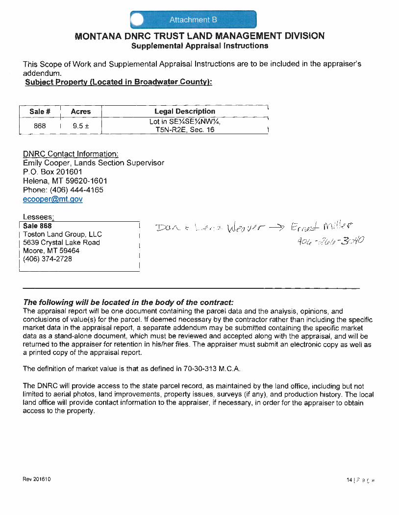
• Attachment B
MONTANA DNRC TRUST LAND MANAGEMENT DIVISION Supplemental Appraisal Instructions
This Scope of Work and Supplemental Appraisal Instructions are to be included in the appraiser's addendum. Subject Property (Located in Broadwater County):
Sale# Acres Legal Description
868 9.5 ± Lot in SEXSEXNWX,
T5N-R2E, Sec. 16
DNRC Contact Information: Emily Cooper, Lands Section Supervisor P.O. Box 201601 Helena, MT 59620-1601 Phone: (406) 444-4165 [email protected]
Lessees~ Sale 868 Tosten Land Group, LLC 5639 Crystal Lake Road Moore, MT 59464
}:::GI\_ ~ ' \ ... - -'.? ,.~~ .:;,\,~ I ' We; v -er ~ E r(Lf,~+- ~'V'1 i d~ ~
4ate - :?tt/'ti -.3<.".J'/0
(406) 374-2728
The following will be located in the body of the contract: The appraisal report will be one document containing the parcel data and the analysis, opinions, and conclusions of value(s) for the parcel. If deemed necessary by the contractor rather than including the specific market data in the appraisal report, a separate addendum may be submitted containing the specific market data as a stand-alone document, which must be reviewed and accepted along with the appraisal, and will be returned to the appraiser for retention in his/her files. The appraiser must submit an electronic copy as well as a printed copy of the appraisal report.
The definition of market value is that as defined in 70-30-313 M.C.A.
The DNRC will provide access to the state parcel record, as maintained by the land office, including but not limited to aerial photos, land improvements, property issues, surveys (if any), and production history. The local land office will provide contact information to the appraiser, if necessary, in order for the appraiser to obtain access to the property.
Rev201610

Sale Location Map
j
Broadwater County Lot
Rev 201610 15 IP age

EXHIBIT 3

Return to:
Ref
Rocky Mountain Title Company 400 N. Park Avenue, Suite 200 Helena, Montana 59601
BXl9094
176475 Fee:$ 14.00 Bk 174 Pg 820 BROADWATER COUNTY Recorded 12130/2016 at 03:01 PM Douglas D. Ellis, Clerk and Recorder By BR Deputy Return to: Rocky Mountain Title Co P.O. Box 268, Helena, Montana 59624
WARRANTY DEED
For Value Received FE Land, LLC, a Montana limited liability company with its principal office at Toston, Montana, the grantor, does hereby grant, bargain, sell and convey unto Toston Land Group, LLC, of 150 Smith Lane, Toston, Montana, 59643, tht: grantee, the following described premises in Broadwater County, Montana, described on the attached Exhibit "A," incorporated herein by reference.
TO HA VE AND TO HOLD the said premises, with their appurtenances unto the said grantees, their heirs and assigns forever. And the said grantor docs hereby covenant to and with the said grantees it is the owner in fee simple of said premises; that they are free from all encumbrances and that it will warrant and defend the samt: from all lawful claims whatsoever, except the following:
(a) Easements, covenants, restrictions, reservations, and exceptions of record; (b) Taxes or assessments and easements, claims of easements or encumbrances which arc
not shown by public records; (c) Interests which could be ascertained by an inspection of said real property or by
inquiry of persons in possession; (d) Discrepancies, conflicts in boundary lines, shortage in area, encroachments or any
other facts which a survey may disclose; (e) Water rights, claims or title to water; (f) Zoning laws, ordinances and resolutions.
Dated: IJ ·Jo · JiOl 4-:
FE LAND, LLC
Bf~,...~;~~;~tt.J!µ\U J. 3-vvt,~fi) ;;;kfu (Ylll.r•'I. k_L '-j cqu;ne J. Smith, Sole Member
STATE OF MONTANA County of \Jl,A,..,A:j S :+-{A ~1L-
This instrument was acknowledged before me on rh:, l3D / ~ \ \J) , 2016,
by faoq,<lioo J. Smith," wl< momb" of FE L'"d, Lia~
Si natu fNotary AUTUMN KIELB
NOTARY PUBLIC for the Stale of Montana
Residing al Helena, Montana My Commission Expires
May 22, 2017
g:'wscn\dlj\fc land, lie - re Sil:k\w.ur;inty Jocd.doc."
l - WARRANTY DEED
(Monlam1 notaries must complelc the following if nol J:13rt of stomp 11 lcfi)
fuA*1.<l lfl1 VJ lli fA. b (Pnnt Name of Notary)
Notary Public for the State of Montana Residing at /d.l.£.O~PJ. Montana~ My commission expires~O"J?fV~ J
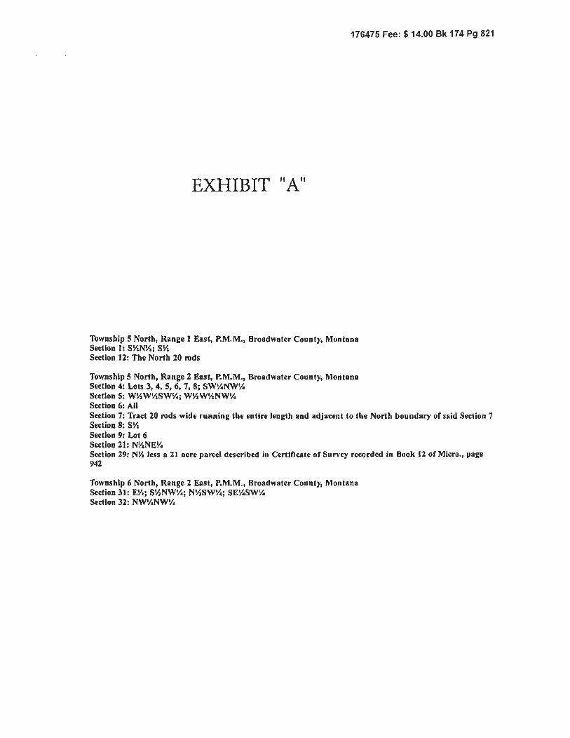
176475 Fee: $ 14.00 Bk 174 Pg 821
EXHIBIT "A"
Township 5 North, Rangel East, P.M.M., Broadwater County, Montana Section I: SY.NV.; SY. Section 12: The North 20 rods
Township 5 North, Range 2 East, P.M.M., Broadwater County, Montana Section 4: Lots 3, 4, 5, 6, 7, 8; SW'!.NW'!. Section S: WY.WY.SW'!.; WY.WV.NW'!. Section 6: All Section 7: Tract 20 rods wide running the entire length and adjacent to the North boundary of said Section 7 Section 8: SY. Section 9: Lot 6 Section 21: N!l:NE'!. Section 29: NY. less a 21 acre parcel described in Certificate of Survey recorded in Book ll of Micro., page 942
Township 6 North, Range 2 East, P.M.M., Broadwater County, Montana Section 31: EYz; SY.NW'!.; NV.SW'!.; SEY.SW'!. Section 32: NW'!.NWV..

ASSIGNMENT OF RIGHT OF WAY DEED Execute in DUPLICATE and return to Department of Natural Resources
and Conservation, Trust Land Management Division Assignment Fee is SS0.00
DS-478
THIS ASSIGNMENT, made this SD day of 0 Q ( Offi ~£ . 20 I l..P , by and between Jack Smith party of the first part and
FE Land LLC of ISO Smith Lane, Toston, MT 59643 the party of the second part:
WITNESSETH; that the said party of the first part for and in consideration of the sum of One Dollar in hand paid by said party oflhe second part, the receipt of which is
hereby acknowledged, do by these presents, hereby assign, transfer and set over unto the said party of the second part, (his) (her) (their) (its) heirs, successors and assigns forever, all
right, title and interest in and to the right of way easement heretofore granted by the State of Montana, described as follows, to-wit: Right of Way Application No. 12405
for a private access road to a single family residence over and across the following described land: NE4, Section 16, Township SN, Range 2E, Counly(ies)ofOroadwater, Montana,
under the covenants, conditions and terms of Righi of Way Deed No. 11 I I 3, issued May 25, 2004 by the Stale Ooard of Land Commissioners for the State of Montana. This assignment
is intended to provide access to parcels or tracts ofland described as: Lots J-8; SW4SW4 of Section 4, S2 of Section. and Lot 6 of Section 9, Township SN, Range2E, for the benefit
of the party of the second part and it is understood and agreed that no other lands are &ccesscd by the Righi of Way described herein.
PARTY(IES) OF THE FIRST PART SIGNATURE:
STATE OF MGV1tkH1 ':'\. Counly of l £ W\ stet~ -.\ . On this _3.£ day of~~ -Y,20_jybcfore~~uegtrffi1&a N.'Jlllilff\l)Jf.ii: fqr~ ~le of I/Vi. b''"V\:+z.t V'\V\ personally appeared
U: fu-! '5'M \W\.. = £5tyy11v\, . wn to me to i>C(cnee'k\)elstiii'lf6r'c0'fPo\'afe'imif fill in corporate signatory's title, as appropriate):
if PERSONAL: the pcrson(s) whose name(s) (is) (arc) subscribed 10 the foregoing assignment, and acknowledged to me that (he) (she) (they) executed the same.
D
AR
CORPORATE: the of a corporation, that executed the within instrument and ncknowledged to me that such corpo-r-a17io_n_e-xe_c_u-.le-:-d-:th_c_s-am-e.---------------~
AUTUMN KIEL9 --1 NOTARY PUOLIC for t11c J
State of Montana Residing at flekna. ll.011l; no I
My Commission Exvires I I 17
Th..: pnrt ___ of the second pon hereby accepts the rights, duties, and obligations inherent in the pa.rt of the nrst part's interests & ownership of the above described right of way easement - --
\
I :S5. Counly of p l A) I s-\-Ct !'NV6-
O&f,~ ,~Ytv~ 177223 Fee:$ 17.00 Bk 178 Pg 284 BR•)AOWATER COUNTY Recordecj,4/2,J;i/2017 at 11 :50 AM P ••.w1l<:is D F.-llis. Clk & RccJr By UV/j_~ Deputy Return to : ROCKY Mourn AIN TI t9't co. PO BOX 268 HEl_ENA. MT 59524
J~ ~1is 2i,?day of 8.Q~.~·fY , 20,UJbefore me, the undersigned, a Notary Public for the State of MU)A fl1. vt A, personally appeared \,.6 ( &,J.1 < 6 \LlL\_L_ , known to me to be (check personal or corporate and fill in corporate signatory's title, as appropriate):
~?l.~ONAL: the pcrson(s) whose name(s) (is) (arc) subscribed lo the foregoing assignment, and acknowledged to me that (he) (she) (they) executed the same.
p( G
OFFICE OF DIRECTOR, DEPARTMENT OF NATURAL RESOURCES AND CONSERVATION Helena, Montana
a corporation, that executed
Fee of~.00 entered: Date: '{JO AMA """"6 .... ,, ()..v 1 ) Amount: Reception Number: ~:H~.F_....,_,$/L7_,__.1~'1"'""''-/,_,J_P..~----

ASSIGNMENT OF RIGHT OF WAY DEED Execute in DUPLICATE and return to Department of Natural Resources
and Conservation, Trust Land Management Division Assignment Fee is $50.00
DS-478
THIS ASSIGNMENT, made this Q0 day of Q..e.C P 1fV\ \?.e Y , 20 I V , by and between FE Land LLC party of the first part and
Toston Land Group, LLC of /So Sm t+h la'V "}:)YJ\ *th. party of the second pan: I
WJTNESSETH: that lhe said party of the first part for and in consideration of the sum of One Dollar in hand paid by said party of the second pan, the receipt of which is
hereby acknowledged, do by these presents, hereby assign, transfer and set over unto the said party of the second pan, (his) (her) (their) (its) heirs, successors and assigns forever, all
righ~ title and interest in and to the right of way easement heretofore granted by the State of Montana, described as follows, to-wit: Right of Way Application No. 12405
for a private access road to a single family residence over and across the following described land: NE4, Section 16, Township SN, Range 2E, County(ies) ofBroadwafer, Montana,
under lhe covenants, conditions and terms of Right of Way Deed No. I 1113, issued May 25, 2004 by the State Board of Land Commissioners forthe State of Montana. This assignment
is intended to provide access to parcels or tracts of land described as: Lots 3-8; SW4SW4 of Section 4, S2 of Section 8 and Lot 6 of Section 9, Township SN, Range 2E, for the benefit
of the party of the second pan and it is understood and agreed lhat no other lands arc accessed by the Right of Way described herein.
PARTY(IES) OF TUE FIRST PART SIGNATURE:
177224 Fee:$ 17.00 Bk 178 Pg 285 BROADWATER COUNTY fl.ecorded 1126/,f'O 7 at 12: 11 PM Dougla~. D. Ellis, U~ & Rcdr By .J)lAJI), , Deputy
STATE OF MQAtuV1 ~
County of \ Q A.iJ' l Si< ! ~
Return to: ROCKY MOUNTAIN TITL CO. PO BOX 268 HELENA, MT 59( ~4
I On th.is::\~y o~ \?i' V. 201.Y. before me, lhe undersigned, a Notary Public for the State of (v\(;)\d tt1VJ P'> personally appeared
\._Cl( J _.( ~VV!- _ , known to me to be (check personal or corporate and fill in corporate signatory's title, as appropriate):
D PERSONAL: the person(s) whose namc(s) (is) (are) subscribed to the foregoing assignment, and acknowledged to me that (he) (she) (they) executed the same.
AR
CORPORATE: the ';J->U> VY\0,W\(l J2of VG' Lu vt.d LLL, · the within instrument and acknowledged to me that such corporation executed the same.
IN WITNESS WHEREOF, I have hereunto set my hand and affixe
AUTUMN KIELB NOTARY PUBLIC for the
S\ate o1 Monta~a Residing a\ Helena, Mo.ntana
My Commission Expires May 22, 2017
Notarial Seal the day and year
, a corporation, that executed
The pan ___ of the second port hereby accepts the nghts, duties, and obligations inherent an M--- of the first part's ante rests & ownership of the above do,cnb.d
0
righ1ofwaycascmcnt. w:~
mnl. M<:;rvliun"'-> ~ County of \.,.Q W \ fi-\i- CiYJi:~
. On this3.\)ayof l'.1l (O.&'.Y\,Yl£1".'.'. , 20~fore me, the undersigned, a Notary Public for the State of lA (5\1\k ~ersonallyappeared Ofu11 c I A.,,~,·· ,,·ce :R-·1:J'.i'.:.;A<i\'\1J1~ N . known to me to be (check personal or corporate and fill in corporate signatory's title, as appropriate):
f llV\l.'Y\t-1 l::J ~-·1 ~'.>IV. \9-0 PERSONAL: the pcrson(s) whose name(s) (is) (are) subscribed to the foregoing ossignmcnt, and acknowledged to me that (he) (she) (they) executed the same.
~ CORPORATE: the MeVVlflt-kS of ti,oivv:\ t AVld (~ i c~ ,•corporation, thatexecutcd the within instrum$lll..Allll.adtu>wledgcd to-me.lb · ecuted the same.
IN WITNESS WfjEgEprJ)~~, reunt<!~f~rilllaKilflf'lllltd m Notarial Seal the day and year first a I /-'•-' · -~ AU"1UMfl KIELB
I I ~!- '\'\ Stall! ot Montana \·I ::, E:!"L) Res1d,ng a\ Helsna, Montana 1 Z\~ . _/.,,.{ My Comm1ss:on Expires Notary Pubhc 'L.'_:_,_' _' '.'.~ _ May 22, 2017 Residing at ________________ _
-- My Commission Expires-------------
Off ICE OF DIRECTOR, DEPARTMENT OF NATURAL RESOURCES AND CONSERVATION Helena, Montana
This is to ccnify that the foregoing assignment was approved and rights transferr day of /11""'1- ZL>/Z
Fee ofSS0.00 entered: Date: f)O 11Ma&..-< ~1
Q I )..o1] Amount: Reception Number: _l-t-_c:i=-~<>"~1_7,_,_1_'-{_,_L.{~3~· ,,,eJ...'-"-----

07/24/2017 MON 9:55 FAX 406 266 3674 Broadwater County Clerk
Return to:
Ref:
Jackson, Murdo & Grant, P.C. 203 North Ewing Helena, MT 59601
168494 Fee: $ 14.00 Bk 147 Pg 302
~001/002
BROADWATER. COUNTY Recorda6\121.2012)J12. a att 4 4 ·19. PM Douglas D. Ellis, Clk & Rcdr By~\~· D Return to: JACKSON MURDO & GRANT PC 2orN eEpWultyN HELENA, MT 59601
QUITCLAIM DEED
For Value Received, Jacqueline J. Smith, in her capacity as the duly-appointed, qualified, und acting Successor Trustee of the John P. Smith Living Trust dated May IO, 2004, as amended on March 21, 2007 (the "Trust"), with a mailing address of 150 Smith Lane, Toston, Montana, 59643 the grantor, does hereby convey, releuse, remise and forever quitclaim unto FE Land, LLC, of 150 Smith Lane, Toston, Montana 59643, grantee, all of her interest as trustee of the Trust in the premises in Broadwater County, Montana, more pa1ticularly described on Exhibit "A," attached hereto, together with their appurtenances.
Dated: December 18 '2012
JOHN P. SMITH LIVING TRUST
STATE OF MONTANA County of Lewis and Clark
This instrument was acknowledged before me on Ne l/e...mbe< 14: , 2012, by Jacqueline J. Smith, as Successor Trnstee of the John P. Smith Living Trust dated May 10, 2004, as
amendedonMarch21,2007. ~ />
".i\TdRYNCONNORS -~~~~ NOTARY PUBLIC for the signature of Nota
State of Montana ReS!01~9 at Helena, Montana (Momann 1101nrics must cnrnpletc the following if not pnrt of srnmp nt left)
My Commission Expires February 0\, 20\5
·------' (SEAL) (Print Name of Notary)
Notary Public for the State of Montana Residing at , Montana My commission expires: ____ _
g:\uscrs\dlJ\'milh, john peter, c•t•tc otlquitclnim deed lrnsl to fo h1nd.docx
1 - QUITCLAIM DEED
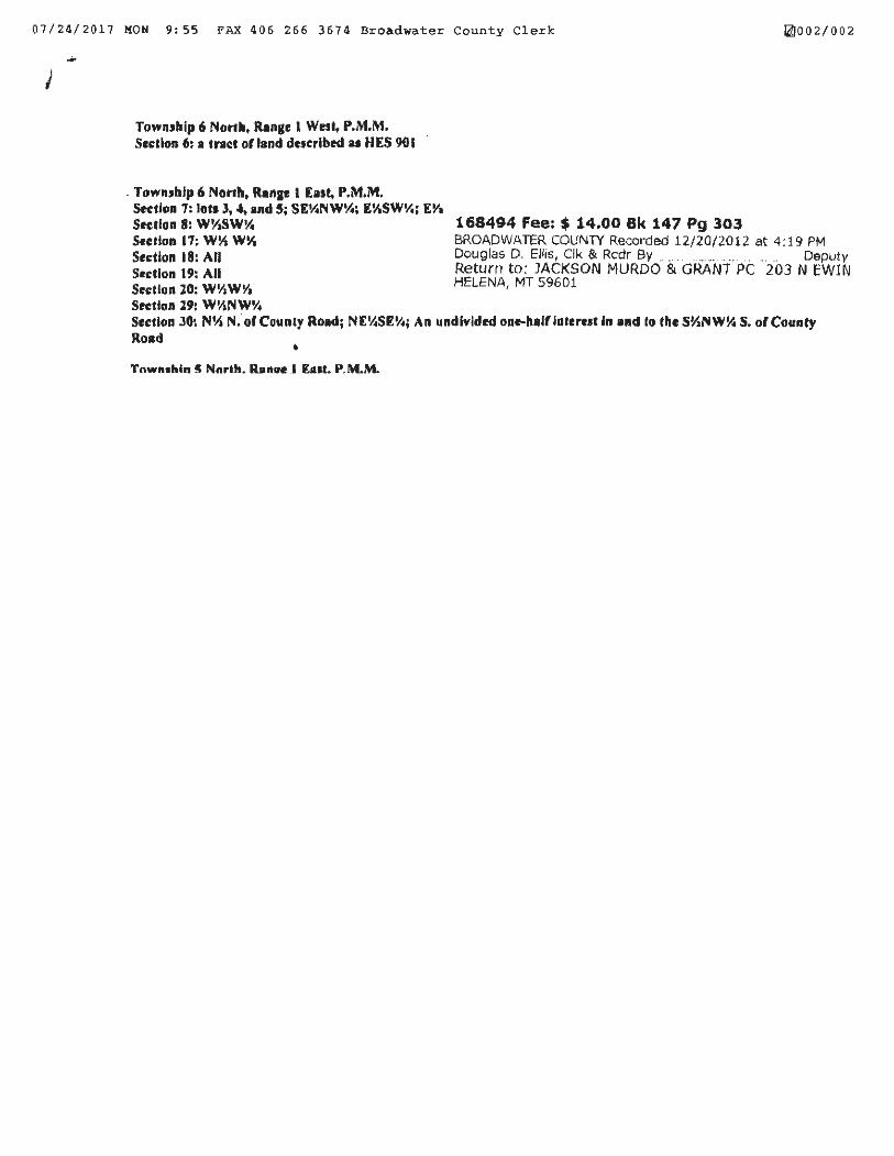
07/24/2017 MON 9:55 PAX 406 266 3674 Broadwater County Clerk ~002/002
TownJhip 6 North. Range t West, P.M.M. Sedlon 6: a tract orland dttcrlbed u HES 901
. TownJhfp 6 North, Ran1e t East, P.M.M. Section 7: lots J, 4, and 5; SEY.NWY.; EY1SW1/0; EYa Section 8: W~SWY. Stcrlon 17: w~ w~ Section 18: All Section 19: All Section 20: WY.WI/a Section 29: W~NW'I.
168494 Fee:$ 14.00 Bk 147 Pg 303 BROADWATER COUNTY Recorded 12/20/2012 at 4: 19 PM Douglas D. EUis, Clk & Rcdr By .. .. . . . .. .. .. ... .. Deputy Return to: JACKSON MURDO & GRANT PC 203 N EWIN HELENA, MT 59601
Section JO: NYa N. of Counly Road; NE'l.SEY.; An undivided one-half lnrer11t •n and to the SYJNW% S. of Councy Road • Tnwn.hln ~ Nnrth. lhncre I [111t. P.M.M.

07/24/2017 MON 10:03 FAX 406 266 3674 Broadwater County Clerk
Return to: Jackson, Murdo & Grant, P.C. 203 No11h Ewing Helena, MT 59601
1f>A4Q.<t c ... ~ ...... A ....... -· • -- ··-
1210011002

EXHIBIT 4

219000 M
218000 M
0 0 !'--0 _J
UJ z ~ (f) z 0 """')
217000 M
216000 M -
MAP SCALE 1" = 2000' 0 2000 4000
E:c:::::JE3C::::==::::J=::=:::3====::::::E=::=:::31FEET ::::::1~~--c====::::r-~~~~~~~--c==============::::::iftn~T~D
m 1 PANEL 0725C J :================================~
FIRM FLOOD INSURANCE RATE MAP
BROADWATER COUNT~ MONTANA AND INCORPORATED AREAS
PANEL 725 OF 1050 (SEE MAP INDEX FOR FIRM PANEL LAYOUT)
CONTAINS:
COMMUNITY
BROADWATER COUNTY, 300145 0725 UNINCORPORATED AREAS
Notice to User: The Map Number shown below should be used when placing map orders; the Community Number shown above should be used on insurance applications for the subject community.
MAP NUMBER 30007C0725C
EFFECTIVE DATE AUGUST 18, 2014
Federal Emergency ManagementAgency
This is an official copy of a portion of the above referenced flood map. It was extracted using F-MIT On-Line. This map does not reflect changes or amendments which may have been made subsequent to the date on the title block. For the latest product information about National Flood Insurance Program flood maps check the FEMA Flood Map Store at www.msc.fema.gov

{XJ 7 T ...... 5..N ____________ ________ :IL ... ~-----.Jb .Ile __ _ County ....... Br.oad'WS..ter. .. ···-- _ -----------------. ___ -·
MONTANA BUREAU OF MINES AND GEOLOGY Butte, Montana
WATER WELL LOG
Owner .. -----·-----· .J.9-.c.k ... ~mitb ... ·-··- ........ _ --·-·-- .. ----····--·--·- ·----· Address. _____ J'_q~t.~:m s.J~gnt~~---·----·· ..
Driller ......... .Y9..n .. PY.ken..J~.r.illing_ __ Q9_9.._ ______ . ---·. ·---·- ___ Address .... lJ?.:nb.~t_t.~,_ __ Hgrr~ang._ .. ___ _
Date Started .......... ~~~-~ ·--~~I.·--~~!±~.---· ____ ·-----............... Date Complete~~~-l! __ }Q1._ --~~_IA .... __ _
Loe a tion : Sec . ._ ....... J./~---· T .......... ..5.N ...... R .... -~·-··· ~ sec •......... NE! ......................... --·--·----·---··-----·---
Type or well .. ···--------·· ........ Pr.tll.~.d ....... ··-· --·- .. ·-·---·. ·-····---·-· ·-··--· Equ1pmen t used ... __ ......... C.h~JJ.::r.~.l.1... ---········-- .... ·-- __ ........ ___ --·· fDug, driven, bored, or drilled) (Cham drill, rotary, o\her}
Water use: Domestic Mun icipal Stock 0 1 Irrigation D Industrial Drainage Other=--·-··------------------------··----------- ____ .. ·-·--·---·-·····--· .. -·---·····-·
Casing: Gr.ound .. level ... ft. to ..... }$----·--·-·-- .......... ft. Type ..... -·----·-·-------· .~on ....... Size ............. 6. .. J:rich---·-··-·····-- . --···· -····-- --
Casing:··---·-·-----.---·-·· ........... ft. to.·-··--·······-··--···-·····----ft. Type ..... ··················---··--··------·_ Stze. ____________ ·---------·· --·-. ------· -·-·-··--· .••.. -------
ca.sing ~ ___________ .... ____ ........ ___ .. ft. to. __ . _____________ .. ________ ..... tt. Type ... ·-----··.---·----·----·----.----·---- Blze ................................. ·······----·· ····--- -----·
Perforated or screened: Ft ...... ·-····-·····-···--·--··--· to ft.·---·----··----------·---------· Ft .... ----·-------------------------- to ft ....... ·-·------·--········-----···
Type ot screen or perforations ....... -··--··-··-··---··---·--··-· - .. _ -·-·--·-...• _________ .... ·-·--.. _ ..... ___________________ ------·- ·-·--·--·-· ..... ·--·----... ···---·- _____ ........ _ .. ·--·
Static Water level, tor non-flowing well: ______________________ . .20 .... ~ ···-·-- ·-·---·· ···-·········-··- ···------····· ···-·-. -···----·------ ..... ----··--·-------------··--feet.
Shut-in pressure, for flowing well =--·--·········-·····-·--·-····--·····--·-··-·-····-.lb./sq. ln. on: .......................... ·-·-·-·····-·--··-············-··--·--········---· (d.a.te)
Pumping water leveL ......... J.9 ___ ............... ·-·--···----- _____ feet a t -----· ·-·----·-~,3- __________ ------·----·------ _______ gal. per min ....................... ·---------
Bow tested:··--------· --~~9:.-·------··---·-·------··-·-··· .. ···-----. --·----··· ·-- ---~--------· ____ ---·- ----· ----------· ___________ -··-· ___ ·---·-----.. -·- -·-··---_ .. ____ .... --· .. ··-·--..... ___ _
Lengtll of test ..... Tlro ... {2) .. .Houz:.".s ...•......•• - •• -•. ·-·----··--······-·-·---··~---···-···--· ·-········-··--·-····--·-· .... ·-·--····~---·-····-····-·····-------·-------····-----···-··-·
Rema rks : (Gravel packing, cementing, packers, type of shut-off , depth ·of shut-off)
- .......................... --- - ......... --- ...................................... - ............................. ,.. ........ + .. - .. - - ,. ... + + - .................. -- ........ -- .......................... -- ................. -- ·- .............. - .. -- .... --- - ...... - - ........ -- ........... -· .............. -· ~ .. ·--. ·- ...................................... -- .......... .
-- ..... ---................................................... --..... --.. -............................ - .................. -.... -......................... -- .......... ~ .................... -.................................................................. ·- ............................. - ........................................ --- ................................... .,.
.................................................... -. ., ·- ................. _ ... ... ............. ···-·-···· .... ···--·-· ............. ,.. ..................... _ -- --....................................... ··- ................... -.. ·-. ., .......... ., --... ···--.. ·-- ...... ---- -- .......... ~ ·-- ......... ··---........................... ---·--·--·-
.............. - ·- ••• - ••• - • - ........... - - + ........ - • - •• - •• - .... - ...................................... - ... + .. ,. ... _,. ............... - • - - ....................... - .. --· • .,., ...... .,. ·- ••• -- ... ., • _.,. __ .,. -- ...... --·. - --- ..... -- •• --· ............ - ••• --· ..... _ • .,., .................................... - ... +- ......... .
.. -.. -... -......... ·-.... --· ----+-• ......... ,. ....... ·-.................. + ........... .,., ........ - •• - .................................. + ..................... - ............. - ....... - ·-- •• --- ....................... - ••• - .............. - ...................... --· .............. ., ......... ., ........................ - ............................ - .... ·-. - • - .... - ~ ...... .. ..
(over)

Log of Well
Description of Material Drilled Deptl1, feet
From J To
o I 5 I clay
5 I 35 I gravel and sand
I I
I I
I I
I . I
I I

County ... Er.a.a.d\ater. ______ --·············· ............ .
MONTANA BUREAU OF MINES AND GEOL OGY Butte, Montana
WATER WELL LOG
---------1 ___ L ___ I ___ j_ _ _ Owner ............. Jack. .. ~tll-- ............................................... Address ..... ;i"-0.stGn., ... Mi;>nt.ana, ............ .
i x I l Drlller ........... .W!l:;l,t.!lr ... fh!MQ!;l<; ....................................... Address ... fi(!li;tna.~ . .l1Qnta.na .... _ ........ .
! I 1 , Date Sta.rted ........ .?.!lP.t. ... :JA .. J.9.5..5 ..................................... Date Completed .. Sept .... J..6. •.. 19.5.5 ... . - - - ,-~ -,-- -,-- -
! [ Loca tion : Bec ...... J.9 .......... T ...... .5JI. ......... R---~----··· ~ sec ... _ft ..................................................... .
Type of well ....................... .Drilled ........ ·······-······----··· ......... ··-----EQu1pmen t used ......... Ch~--Dz;.o.i.ll .. ···---···-· _ --·-· ··-----· ............... . (Dug, drl'1en, bored, or dr.Uled) (Chv.m drUl. rotary, other)
Water use : Domestic Municipal
Indust rial Drainage
Casing~ _____ g:;:q~r:J .. _J_~_Y~:h. to ......... JQ .... ··-···-· ..... ft.
casing: .......... ·······- ···-··········ft. to ................... ·-···· ....... rt.
Caslng: ·········-··········· ........... ft. to ................................ ft.
DI 0
Stock [!] Irrigation D Other: .................................................. ··········-·····-··--·····-· .. .
Type ............ ___ ... .Iron .... ·-·--.. Size. __ ............. 6 __ .inch. .................... ·-·· .. _.
Type ............................. ····-······ Bfze ..................................... -.................... .
Type._ ... -·._ ... _ .. --· ..... --- .......... _ ... Size_ ............... _ .... -· ·-.... __ .. _ ....... __ ........ --· .... .
Perforated or Screen ed: Ft ................................. to ft .................................. Ft ................................... to ft ....... -------··-----·-----···-·-···
Type of screen or pe.rfora tion.s ...................... ··-····-··············-·····---········· .... ·····--····-······-· ······-···-·····-···--·-··-·-·········· ······-········-········ ......... .
Sta tic We. ter level, for non-flowing well: ......... 2,? ............ ······-···· ............ ···········-- ....... --·· ............................................................ feet.
Shut-in pressure, for flowing well: ........................................ ··-···--··. Jb.I sq. in. on:··-···--········-·----·········-···-····---·······-··-··--····-········-·· (de.t.e)
Pumping water leveL ........... --·-·······--18 .................... .feet at ······-··· .. --·····-·-··.20 ......................... gal. per min ................................ .
How tested~-·········-·-····· ·······--·····-~.d ..... ·····--·················-········-·· ····-···············-···-·······-·· ······-···········-··-·· ..... ·····-·······-··-·· ····-·····-············
I.ength of test... .... '!wo ... C2.~--h~s.---·······················-·······-·······---·-··········· ···········-······························-················-······-··-······--·-···-··-···-····
Remarks : (Gravel packing, cementing, packers, type of shut-off, d.epth of shut-oft)
......... ·- •••• - ___ ....................................................... - ........... - •• - •••••• - - ................................. ..ii ................. - ••• --- ••• -- • - - ••• - - •••• - -- - •••••• - • -- •••• -- • - • -· -- •••• - - • - •• - ..... -- • - •• -- ••• - ...... ·- •• --- ...... - •• - • --- ............. .,..-.,. .......... ~ -- -- ...... ..
................. ... ..... + ........ _ ........... ·- ................................ .. ............... - --- -- ........................................................... -- .................................... - .............. "' ••• - ...................... -- ..................... - ..................................................... + ..................... ..
.. • • • • • ... ...... .... .. ..... .. • .... • • • • • - .................................... - ........................ - ..... -· ................................. - ........................... +-- - - .. - - .................................................. -- ••• -- ............. - ••• -- - ••• -- •••• ---· ......... _ ........ - .... + ....................................... + ..... -- .... ·-
- ........... - .. - ............. _._ ................ - ...................... -- ............... ,. .................. - - •••• --- - .......... - .. ..ii .......... ,,._ - -- .............. ..ii - ............. " ... _. - • __ ,, --.... -- ............ -- ••••• - -- • --.. -- ..... -·- ••• - - • - •• --- - ............ ----. --........................... -- •• -- ............. - .......... .
.. ... ....... .... .. . ... ..... .. -........ -........... _ ............. ·-........ -.... - ..................... ............. -....................... - ............................. -- .............. -. ·--................................................................ -· ..................................... -............................................... . (over)
Log of Well
Depth, feet I From I To
Description of Material Drilled
0 Gravel and sand

r
GW 2
Cmmt;y .. ~e.Mr .......... A ........ H .. .
ST.A.TE OF MOW:£ANA f /, itrJ ._X1\ :1::~::!'EODE·o /\
LOG llJ) I Top uf Ground { 1
ADl1UlllBTRA:TOB. 0 GROUNDWATER CODZ { .'10 7_.Q_J 0. ~ FlOEJ OF STATE E?fQINEEB
Notice of Completio . .n of Grou.ndwater Approp iat ion by ,Means af Well
DEVEL()PED1 AFTER JANUARY 1. 1062
. ~· (Elev. abo'Ve s a leveL~.-- - - )
b;. nd 6 0\) E' ll (Unde:r.· Clrn1Jt r 237! lhiulAA1 11 • e.BMOTI lJOWS. l!JlH
0 wrw1· ... ~~~ .~~-.-.-~----·· -- ....... umuw • .Add.res!';_ .... l'oaHJ:a. --~""-- ........ DriUet~Wt~ ... ¥.1' ll.l . m.P.U4tAdllreS!L.&6.t. ta .... ~-. -uUUU~
Date or Not.ice l)f appr<ipriatirm of jil'Pl.Ul<hvn'tt"T'm.MAmftPJ ... f---1969---- .. -· .. ·
fwat.r)natA well stnrterllM.•---~-~~ ....... J)at~ ,c-,nmplefod.. ~--7 J.969. ....... . • • • • • • •
Show exact 4.epth of bottom.
'Type of w~l L_.6.ilrl Jl Mlm ...... ----· ____ .. Equipm<.':nt 1~~ ·~fi .. m.u~····\al•m.-(Dug, 4Yi'\~en, bond o.1' drillcd)1 (Ohµni: drill, n;i Dl:'y or oth~:r)
Wu~e-r· U'Efl: nnmesti' D li·~unfoitHll 0 Sto -k IrrigQlicm D lfi1 Ll;lstnn.1 0 Di•aiwigt· D Ot h4"1' 0
In Jici.ltl~ n __ t n:ingram the. :Chl\tact r nn<1 thklrne~ of iirn LU ri'r·rput sfrata nPt ,,._.;-th in dr. ' , ing
1 • n as t>i1, la7 shah~. M".tflV•U • . rnd<r urr ~ud, ~tl:l. 8h6w
tle1>tJ1 at ~~ltirJ1 '"''ti r is e..11 i1Jiitmt€!n·J.~ th1 ~ul ~~ lit cbiu·n(•tn o.i 'mter-henring ma.ta flind t.i i.gln. to whi ·b tJ;. water ds:t.!s· iu t.b ·wf>n.
I
~----J __ __ _ _ I I I
I _ _____ J ___ _ _
I I I I I I
Sbfl pd
w ....... or :m.llia,
s
I I 1 I
----- - •"" I 11
'.F'l"lll!ll
fl'mtl
o'
J~J. !T_f,-S<! ~!§._. T .. ~.~L Il ..... . lrn 1 i r~ntr. loca:ti' 11 of well nru1 pl1u · ,if t"IBe if pi ..,. ibie- 1J'ad1 smdl l:lQtli.t e r -·Ji>r 9 m.~ 40 a.ere.~.
-T.P
W-9~ PEBFOlU t'I ~~
K.huf Fn'.Hn Ta 'h:r (°RM'U 11-'..:1
--· .-o• .,.
8tatic W-ater Lc.rvl.' I for non-fl• willg well
----~~---~.,.. ..... ---..-"' tn".:t.
£hu~i11 l'r~ssurn foI' ~1lmnn~~Weli ... T ••••••• ._ •• _ •••
Pt.:unping :\Vo.tcr J.eveL .. 30 .......... -·~~-·-·fcct
a t·-····-~~ .. --·-······-gru. IJ . 1~ mim1t<?'.
llifimh n.['ge in ~al. p1 T .miu.. of f1 1lf"iag " .. ~u
···-········-······-~ Iluw Tcsted.-.. ... -~t~;_ .......... m .. -~- ..
Length of 'l'cst.._ ........... _ ...... ----····· ·······-··- -·-~ .
T'-emark : (01.·aval piu~kiug;, cemenlhlK~ pack:-
'P _ .......... _ ............... -~ .. •• - ................. --··--···---............................. .
• t + .... r .... -_ ...... _ __ ........................... ~ .... ••T ........... - .... 'l'"'P'I'----.----•·---...... __. ...... - ................... -.: ........... -
-~··· .. ···T·--·~·-·--···-··-···--~·-··- ·-----···· ..... ---·--· ·· .. ····-···{Ocntirme rm rrv. r~•? sidd
USE K ns.cd io1· i<rngQtfo11 1 rudu&trial, t11·s.lnnge or other. ExplnJn. state num her or a.ure~ an.cl lnc.a.tion ur athi;;1r data {i.e.: T.iot 1 BL• k and :Ad,U-tlim).
---••••,.•••-"""' _ _. ....... _. .. + ... -...., ... •••••••-•.....,..-.•-&.a•• ,._,.....,..........,. ___ ..,_ ........... r+ ...... ---.-&•.&••••._._._,..,.._..,___ 4• ••---~ ................ ..
,,_____.. ......... ...,__..-....... ~···· ··· ·--~...--..~ ............................................................ __ ........................... _ ... _____ ............. -............... _ ..
~. 119 his f orm ro ~ prepar,ell JJy "1'ci1 Cl'. and tlirt'tf!- cnpl.c~ oo be filed by thE" O'flll1r wjuh Use
County C!cT"k :mJ .R.eco1·del" JJI the ~unt-y iri which !...be well is·· Jo~ted, tissue coNr to: he
.......................... - ............... .....-....- ...... ._ .• -TT----._ ...... _ _._.__._ ...
.. ~ler J • . ~~~m rlit..aine·d by d!:illru:·.
Please nnswer ali qQCS;tiuns. It not upµlita.ble_. sn state., llfhH-.vi&e the form wi11 be ~1'.umr.d.
. t\L .!-.l..L4i .. l.TO , .l.-.
11riU1'"l'"1
S. ~i 1gnatP.rf ..
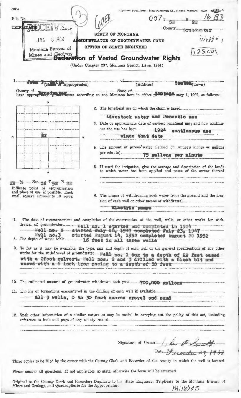
CW4 Appr~ ... '~d :-itod:. Form-S't:i[t:· PL1bhl.lhio11 Co .. H!!leno Mamll.11 ;i.-.ii.r.J-1 ~~
Q 0 7 T .... h"., ···--··--·R---2-·:-----/~~-8 --~-:>... ..,,
siATE, OP MONT NA
MINIBTlt.A.TOR OP GROUNDWATER COD'E
OFFIOE OF STA.TE ENGINEER,
b,;~=====i~elifl~on of Vested Groundwater Righf'S
?A) l!Jj_; I
D J-SlO~ {Under CJJ.npter 237, lfontana Ses~don Law9, 1961)
Lm~~-1om. :r fNiili~ApprOprl~~-j-m nun • •----- ------- I of .... ~.• --•(A~)m-rnu• -•~--,.ll~(T~;;;.)m~u·~-
~::t~p~~-~d~~~r---~~~j.~g~t~l•• • th~--M~~-:~~ 1~;;·~--~fi-;~i- -ifffMl w;,;;_~;y-1:--1962~-·;··r~ii~·;···-N
I to I ~ I
I ~ I I I I ~ I I • I
- - __ , - - -- .. , •• - - • •• ..._.__,._ - .... --- 11 - - - - 1• - --- .. 1 ... ...... _ _ _
: : ~ : : I I ~ r I I
• " • I I - - - - -·-- - :· - -- .... :----~1 · ... ... ... -:-- - ---- ~ - --- ~----
• I II I I i I I 1 I ---- -· .._ ... -- ---~----- . ----:- ---:---:1----: : I : I I I - 1
1 ,,, .. 1--------...-.. ...... -...0:------....~-1 , I I
• __ • 1_ - - - I - - - -i •
' • I
I :
--- -:- --- -~-........... _. : - -- -i ii I . . ' - - - : - - - -: - - - - - - - .. ~ - - - - :--- - ~ - - - -
I : : :
I : I I ----.-- - -----,- ..... -- .... ;-. __ :
J ..... ~ • .11'.··· ·- -~- Sec .. --},,£. . T H-:.;-- .• R. •Ill lJ ....
. I
Indicate point of appropriation and place of. 118~. if poasible. Ea.ah Bma.11 square repn~sen f.E:i 10 a '"res.
2. The beneficial use on whieh the claim is based------·--····-···--------------·-
------·tJ. vee\0-c-~--=wn-t• r and--lliimiii-a:cf ··ua-·····-----------··· ···---a. Date 01~ epproxinto;~ date OT earliest benef:ie.ial use; and how continu-
oua the m~e has been_ __ ________ ____ 1924-·---uontlna:crus--·u.----·-------··-~- - ---------··nuue ···1'111.-, --aa M --------------~·---·---~················-·------
4-. The amount o-f grDundwatel' claimed (in m.iuer~s inches or .galloDB
per minute) ··----------··-·-···15···p.i.t.-ona --per a:1m1u-------------·--~· ___ ....._ -- -- ----••-.. I'.._.•• ..... ___ •---- -- -- - • -- ......... - ... .-w-• • • • ••• • • ................. .0. ... ___ ......- ..... - 'P • P"'W'T'P _.., • r• • • • • .. •& ....... __ ...._ ---- - -----
5. If tL~d for irrigntiou, give the acr~.age and desel'iption of the 13.nd.e to which water has be~n applied and Dame of the owner' thereof
6. The means of withdrawing s11c.h water from Uw ground and the lucu
tiou of each well or othe-r .mean11 of withdrawal._ .. _ ~-~--~--_
---·- :n ao'tl'l'o"··~-·---·-.. ·-·--·---·----~---·-·---········ ·---·~-·--------
7. Th~ date: of tonnnencement and completion of the (~m1strrwtion u:f the wall , we.Us. or other worb for with·
drawal o:f gronndwate1• _ _ -·· ···· -· _-i--- ~·10 " . 1 . c ta'r~ctc"·· .. 3,c~·a:r-·:w:-E • :..:, 1 o. lJ~..:.-lr-- ---- --- ----------------.. --- ·--- ----·- .... e- -l---\.10..-· ~- ----- - - ·e-~! rt~c. - J - -y---18-1·--±'J ·q --oo~p ·f!-tet;· l:~u-17·- --~:;-;- --1 !Jll7 · ·-·····~--
'B. , , .. w~l . n, • 3 11 ti. ... rtoe \U.!.'"'UP~ t 11~, ... 31 c~LJ.p,l~ tee:. ~u~ue t 2- 193,2 rih.e depth ,1f water table. ---···- ... -}.;f---f-eet · --;l.""""'l; -- t!'INC ~tel1 ------------------ - ···· --------- ------------··--- --·-· - ··
10. The estimat<3d amount of gronndwater withdrm\"ll e~r.h year ____ __ -100,000 --geli:one------·-----····· ······--------------
11. Tlle Jog of formatione tmr.mmtere<.1 i11 Lhe drilling of euch well if avail&ble. _____________ .... ······-·····-·---------·---------------- ---------&l-1----,.- well-s-,---e---to---» · · taat---ooarn- gm110 l au.4---uaD,----- -------·~--.. ·····--~~-~·-· ···-··
12. 8neh other information of u smiilnr nature ns mny be useful in carrying out the policy oi th.ls act., iucluJing reference to book and page m o.ny cotmty rccm·d . ·-------------·-------·~·-············-··-~·--·-···~~-·-···--~--------~·-·-·--··
~
S\..,IYiln.tuJ:e o:I OwnAT __ ~---P'~-~ --·~--Date _____ "~l--:~·--p . .-:.1 ··-f'l~/;·i
I
1'hree copies to be filed by the owner with tlJe Couuly Clet·k !l.nd IlC{!.<Jrder of th~ cotmty in wlricl.J thP- w~U i~ k1<'oted.
Pleaae answe1· nU queations. lf not :rppJicablc, so stat(~. otlmrwise tl1~ form win lu~ rr:t.nrned.
Original to the Connty Clerk and Reeordcr; Dupliente 10 tlte State Engineer~ Triplicate. to the t.·Iontrurn .. Bm·cm1 ol Mines fl.Ild H~ology7 a.nd Quadruplica,te for the .t\pproprh1tur. (15

ow 4 ..i~,;:34 ~!
II? f3J)_
G o~ 0 / /
STATE OF MON-rrANA '1
A - MINIBTRATOR OF GltOUNDWATER CODE
OFFJCE OF STATE ENGINEER
Rights ( [nder Cl1n.pter 2:n, Mont.nun. Session l1nws, 1D61}
1.- - •. I of •-• .., t-·· -- --· ·····~-• 0 fi r>n( Town)
---, - --· · ----
- . : ~ ..
~
I
t
I I I
- - - I I I I
I
I I
, I ' I I - - -1 - --• I
I
I I ._ - - -
I - - -- .. I
' I .. ·-- --1----
1 I
' I I
it.. IJ!.,.,_ 6 T R , .. ~- • - 1-!it ..::J...: .... " • ..-:::: ~ ._.q:,;.1 •OJ'~ ... . ~-' c ... !lldica1 • point. of :t pp ro p1'ia ti on u nd p1a(!e of u;;f!. if f>O!i;sili 1€'. Ea.· h smnll ~qut1 n· nopr~!~<'?l l l; 1 (l ac~rcs.
E
( AddrcM)
2. The hentdfoial lliie ou whieh llw •lnirn is bl!..8ed -·-· . -···-
.... :1 viif; t3-c·! - i.n tE: r a.nd -r:c"i-tfr~·tra·· "tiifii--··-·--··--···-··········
3. Date or nppraxirnnte dnt.r of c11rii1!st beneifoia..1 use; anii how eontinu-
.f.. The amount of ~nm.1rlwat.er claimed (lu niiuer's inc.hes or gallons
per minute) ..
fl. If us('ld for irriga tio 11, ~ ive tli ~~ m>:rea~I! and <l cacriptic11 of tl.le Jan de to which waler has been a.ppllecl :1ml rmme of the ownur thereof
fi. T h.o mcm 1~ 0£ wi th<lrnwin ~ snc h w::1tcr from the grou u d uu d the lor.n-
tinn nf each well <.Jr olber m ans of lvithdrawal
·---·~--··~·::u"tnc·~·1'~i"tr -- ---------~······ · ··········-~~.~~ ·········~~·-----·-
7. Tho dntt.' or eu1tJmc·11c:.l 1nwri L :tnd Ciimpll.'Liml 0! the ('.( mitruc.tiuu oi the wcH. wdls, or other works far with-11tcn,,•til of 171'01171 d wa.tr. r i i ' " ~r ·:er_ - ":.i.O, · r t-':1.l"""":;Q{.- · ···:.1c ·cro-'-;~.:.-a ~~,_~ ·1 n l')-~n.
·ell -a-th·~--- -··e-t--··rt~tl- -July l ~,, l·.Y·-7 -co"'!':";l·t.?-tt?c· i.lul7 · ·1:·3·;· ·1:.t1~y-'.~1 ll f~o.3 ot:!rtod ·.u · .. cc t l''• 1))2 co.w.f)li.l tat: · u-:;!; t 2: l'J:)2
b. '!'hf> depth oi water t.nbl ~. ... - . · 16 -~1''C t t-=1 r.11 ·-thro i;: ; .u !_·l-rr - -- · - ·· ·· ·· ··-· ··-~-----~·- ·
fl. Sn foJ' ttB iL nrn .. y lu! ~1.va1lnJ)le, tbt)! tY]le) size a11d <lcpth of ~~nch well or the ~encral spceifieri.tim1s of 11ny oth~r
w11rkR ·for tlu' w i l.litlrawaI ot •'l'rClUHdwater ..•.. ~ l l :-in-. l <' n ~- -t O" ~ L1 c--. ~h 0 ~- :2°~ .t<Hrt· ·-e"tHl"Od ··-Wi tP.t··e-· 2f'·· ..... 1)t··ettlv·o-rt.- --:-oll- -uoc-• ~--::md __ , crt-llc~· i:~ th a 61nct1 ---01 "t ·c."!id _____ - · ~·.s ~~ti ·wit~ ':.i .S · ~~ h 1 ":'"O:r -Cr.'!~:1-::.:c -to cr ·- ::-----, ~.~i. o-~ -7.~- to·o t
Ht The est.unatr•a ammmt. of groundwater wit.l1rh::i.wn ead1 ycn.r. .. . 7.:41.000 -~·llO~P.;----- -·
]] . The ]og of fnrmnt.1nm:i CJU~flUUh'rt'll in the d1·illing- of encl! won if inrni1a.b1r.
---All-· } t:(f l l·c-··- e··-1;0-· ~ fec-t·· c·y1rc·o f,T"'1""t"0-1'"-·n.nd"" ··s:i.nd __ _
12. Surb otlmr informn.t.iun of n sirnifor rw.tnm n.s nrn~1 be usdul in carrying out th~ policy o.f th.is net, lndulling rPI t'r~·uce to lh>1.ik H11d page of any cou11ty rt~r. ni ~ .... -············------··-·- ·······&·-----·--------- -.. -· ... . ..... . ..... • +- _ ... - - -·- .. _.... .. ... - .____._ --- -.. .. - - -- - ....... ----. ......... - ..... - .. ~..... • •• • • · ................. _ -
-· ...... 41 . ---.. -~ ... . ..... ··- ................ _
Darn .. . ... .J. . . ~ - ---- I --11 --.."6 :.. • ., •
Ori~innl Lo thc1 County r·1r-rk :m•l H ... ~orrler~ I >u1)11('31r' td nw ~tatr gn~inr:C'r, Tripli<'H1P l(J thi• 1'fc·i111111:1 Btll'Nlll d ~fo 11 ·~ u n d \ l r-nlog,Y, ~m d 4 t1•-1d n1 p1i• •n h~ J\1 r (he A fJ (I rup 1· i;J I< •r.
'
•
i
f Ii
I.
I

c•w~
R 2~ TRIP
1.
BTA.TYOF MONTANA I' - , JAi·i v .j•_1-t MINISTRATOX OE' GILOUNDWATE:R CODE zu_;_& #-- 3
\ill1iP~ ,
1
ML.-~n. t~na ?.u; ea.u 0VJ· ·.· . OFFlOE OF S'I'ATE ENGINEER
MiueE ,u_.d...(eo~-:: -r , - f d d h -~---~ :ueE-ta on o · Veste Groun _water Rig . ts
( G n<ler C1IBpkr 237 1 Montana Session Lawg, 1961)
Joh..--i. ~ ~N~~1~ipp~p~jator) I of ·~ -fAddreM) ___ ---- ·-··-·. ":1os_t_t)ii"(T~;~s ----------------
~::~l'~,:;;iP~i1di;~m!tf:tf~~ter---~~-~~~dli;-g . t~ th*' Mo~~a~~ l~~~s in cH~~t-ir~fflt;;-!fhtii~rn.ry 1,--1962~-~-f~ll~;~·;···· N
I
: : : I :
- - ' - - · - ' - . -- ' ~ --- :- - ---- - -- : - --r I
I : : :
• - 1••--.----1----- · - ---1...-• - 1 --- 1-----1 I I I I
• I _ I --- ~- ---1 ----,-----
' '
-- ----. I
I ... _ ..... ___ ---- .- - - ... -. .
; . -
s
I
I . - . - - - , ~- -· - - - -I
I I - - -- ~ · - - - -1 - - - -
I I ' I ' I I I ' I !----: ........... : ___ _
2. The he.ueiir.ial 1L~C mi which the d.aim :is baaed_ ___ ............ ·-·-~--------
-- - ·11 ·v c· s t:~)-ci! -\.-~1 te r a:W--~olfo i ·trc;·----a-~-0·-··-- · ····· ·· ····---·-···· il. Dntc or npproxim l'l.te d :i tr nf cn.ru~,et bC'nefi ... i..nl use; un<l how con tinu-
ouA LL e lL-;e ha.a been
4. T'lH~ a.mount of gromH1w:J.tcr ~lRimctl (iii miner's incl:Jes or ~nllons
per minute) ...
f>. H used for irriga tfou, g i Vf.~ the acreugc and de31Cription of the l.an ds to which water has been apr1lin~1 .a.1i.i name or the owner thereof
.~··: --1i4. - Sec_ -16 T.5~r R,, 2-Indfoa1c point of appropriation .ond place of me1 if po8sible. Ead1 gru~Jl 8q uure represent 10 :rnres. G. Tlrc merma or withdra.win~ :mch v;n1 f~I' lrl)nl the gronml nud the loca
tion of ('tlCh well or olh1,:T' me•mr:i of wiL!uhnwtLi _
-·····--···1_:.~·:rtr"trt·c-·--~ll!ni'~- --' ··- ·----~ ----- _____ ., ____ ..... ·---~~-···· ···-~-
'7. 1:'hP. dat.e of eo.mn Le ucement nn d comp le ti on of th r. c011.i:itrnct.ion or Lhc well, we Il!i. or other works for with·
rlr.awal of ~ro1mdwater --- u-:: !--"":1o. 1 c-t::r7"~~oc· ---~~c - c~r.~~ rrtm; · -1n-- - 1·)·~·!-; ·-· ··-··-··----~·----~ · ·'!' 11 '1'&1t ~-- ··~tr ~-r-t.~ci J tJ l ~ l f;, l 0h-~f · C O,..!~l:f?"tct; i1 ttl j ' · -~ 3-. l) J~ 7 .. -~---··-·---·
4
.. -1 .. ll :lo.-.. ti ~--rtoo · u-l.:~ t ii~ 1 ,-) ' c-" .. , '"l·"' .Loe~ · u~,. r-- • :? ~ ir1 ~.-:. ~ I - ..__ ' ~ '-,p u . ._._t1 , ~--- .... .. :: 11.Jt,t,.;. " - - J ~G.. ~- 'l'lir dl~pth of water tubJe. ------ . · l 7 · -£-e-ct -in ~l l ·· ~hrr;c -;,-et-ls-- ·------ -- -· ---~---········· ········
~- So fol' ua it may be ovu.iJu.hlc. the typt:) 1 size anfl <l•_"ptl1 of N1ch \ ... ·dl or the g1mernl spe<.~ifiC!atfoue rif .nny other
wm·!,s for the withdmwnl of groundwater - - ., f .. ·•l .... r"'I • ' -ru"'· t~ 11-- -..,;;-o:"--O:•} ... - a.to--- ""t"",\'- ·rn .111-·---c-,.._·.w,-,N ..... -.Ii·,.. • J. ' r v -• w. '"' i" ,, :...r. .. - ._ 1t.0 ~ ~ u u u "'111
li-i tb ·e 0!-·:·o·t eulvc-rt.- -····e-l1 not.;. :" ~'!. l-:ri 3- crll!-cc·---t:1. t!~ n.- finch bt-i---nr."d -c-a;e-ee ··w! ti..1 a '5 1. ~e-h ! '.!"o :1 cc.11 i ~,.... tr ~1 -c. ~ ~-~ 11 o~ ·yJ- -f cro-t- ----- -- -··--·----·-··- --
11. The lag l1f ronnn.ticircM CJll'.tllinlH1~ d in the dr.i.llhi~; of c~n<'h well if l!vnilablf! ·- .
I~. So eh otiler inJornad i•Jn of u similm· unt1l r1:. n,~ 11rny Ul~ iisefuJ in l'!lrrying out t.h~ policy of tbis act, i11elnding
reff·f(lUC(' to hook and page ('Ir o.uy comity recnrrl __ ---------······ ....... -·--···········---···-··--~··--···----
;:'1-.; ... --+ - ·--- . -··· ··-- ~__.....,_,.-.. ..
Orig'innl to the County f<Jcrk :mt! R•·cor<lcr: nuplkatr tn tlrn Sbte En~rinr.('r; Tripliratr to th~ .M(IJ11flr 1 Ji Burenn of :\fines nud t l!\ulo~y. ~rnd (~n:id t'll pl j4·ri l1._ fur tlw A pp1·01H'H1tor .
t
•
i
I.
J
• • /lo I

GW4
JAN G EhA
/
S~TE OP MONTANA
MlNISTll.ATOJt 10F GBOUNDWATEB CODE
OFFICE OF BTATB ENGINEER
~M~J~.n·_::;:es=a:::;;~ ;;1Je1Rl1'Bt1~- n of Vested Grou.ndwater Rights {Under Ch~pter 237, Montana Session Laws, 1961)
lu'tfl. Ji (
D ~:i.~,o~
I 11
I I I I -- ... - •- .... .,.. - ... .. - - - -• -- ... - --·--·· - - - _1 _ _ - - .1 ____ -
r 1 I 4 I I ' I • I I
~ : : ~ : ' · - - ... 1- --- , - ~-- 1-- - --- - ·1- - ·-· - •----1--...,,,.-~ I
11 I • • ~ I 1j I ~ I 4
~ ~ - ,_ - ~ _____ ! .. ___ ) : : ~ I ~ - : - · - -= : ---- ~----! I II I I I I I
: : : ~ 4
-- - --~ --- -~ ··-- --- - - ... .. 1- ----, r
• : I
: I : : I : I - -r .. 1 - .-.- , ..... = = - --- -, ---- ~- ---- 1
' I
' I I -.a. ·· : ---: P'W' W-: -=r-- 1---- :- ---- ,·-"' - .& .&
I I
'-
, of ____ _
2. The beneficinl use ou which the claim is beaed_.~-·········-------·······----·········
-- ... t1vea toe .:--·wate r ·ADil · ··110-m•fa ·t1 a----u·•-·-· .. ······---·· --· · ··--··-3. Date or approximate date of ~al'liest. bm1efieial use; and how :eontinu ..
()lll the use has been_ ___ ____ .. -- 1924 ctratlnulJU9-·u:s1r ··-·····u·
···~-~----·- ··-1-i.u1 ......... ,.:.---· .. ··--------·--· . . ··-------~··· ··-~--···· -------• -• ••o. ..... ....__ -----r • .... r--------- ......... .-... . ._________ . __
!. The a.mount of· groundwa,ter clain1ed (in miner's inches ur g.aHoll8
per minute) ····-- ------ -· - ·75-·-ga:1:1-oa.lf ···pay--unu.-----···· ----· --- -- - r . ... • .. ._.., ___ --.- _ _ .,._ •••• •••• ._.. --- .....,. • rr-- &• .......... - - - - - - --- ~-- --- - -...-. • • • • .. • o. ... _. _,... ... - --- - - ... .. _. ..... - - --- -- - • • • • ...
5. If used for irrigation, give t be uereuge and d~rlptim1 of the lauds t.n which wa.Le-r has been applied and i:1a.mi: of the !)wner· theroo-f
.......... ------... ... - --.-- .. --- ........ -...._._ ... - ......... ~.---- ............ ----.................. --~ ............................. __ .............................................. _ . . -.la---·-- Soc. l6- T .·-. ·--·- R ,... ..,.. (..
- ................ ..................... _ ...... _ ... ____ ____, ... p- -- --- ...................... ~- .................................. _....___ __ _
Indieatn -poim. of nrpropria._tiou .o.nd pla-<:e of use, H poss.Ible. Each sm..a.H sq_uare repr£IB~fl t,s 10 nr. res.
~" .................... ~ ...... ------.. -- ......... - ••• _..__ ........ ________ ... __ p ____ ...-- ........................ ....__..,_ ...... -~--...... ..._
6. The means of wlth.drnwing such w11ter from the ground illld the loc~
,.. '·
tion of each weU or other m •an:SJ or withmawal __ _
~~-HH• neu tdoU-pu..,.------·~ 0.0 --------HOOU&~•~&~~•HOU•-----· OH Au---........... -------............... - ....... - ................ _____ ,. ______ ..... --.. ................ _ ..... J> .. _________ -- -- ...... _ ... ________ _.... .................. ......_ __ ___
The date of eommt}noement and completicm of tlrn &mRtroc.tion of thr. well, w.eJls or other "'orb for with· d rawal £ - - . d · -tA · ._ o groun Wll , .r _ _ ---·-..,.. . ~ . ~ L --f' ,..~-•rr<'"'lr· . • .... --r.-...,.,.-..,, ..... -..'!"'I"~· • """ -~-- !!rc ~-4.""~b. --- --~·-~~·· ··-.....
U -. I • t..' \l'Clo .I. .. 'll! U ..J !., V ..! .., _ '~ I.I - iU. ... ~°;I --- --~ ~··~·---ell- ·ltO-ii ·- · ~- --- ·· · · ·e:-t~-r-te c. 17· .. l ~ • --l,-)cl .. 1- --con.., - - . ~( l ~. • 3
B. Tlrn depth of water t.ahJe
9. So far as it rnay be o.vu.ilal>le, the type, size and depth of eaeh well or the g1meral specifiC!ations of any other wrrrkH for the withmawa l of growidwo.te-r ____ ·-·ell--:-1 . ----i- ·i{1u.r - er·- ··· c t:p1!
0 f 2R"F·--re ~-i:··-e:-l! -g ~ ~
-'h'! tb-- · "ft- · ·2£~,fl ··eul -.. - • e .&. - 0 't° •. L -~ncl -3 rtli-crt, ___ :1 h -n --6 •m; - r t. fl.r.tt---efle·o..tL l ~ f-t.'r,_ - -~; - 1-~~-· ·~- ' ~ ·---- - ._.... __ .,,.,. ..,,_ ..._ . _,... ·· ~'.'\-- ~ - ~--~··---·····-~-~~-·-·····-----· ~ """' II ... .,,; . ' ......... _,.!I - V ... .!. - .,u; W ...... \,,,,;. · ... .... lj.fl !l!!o ..... ...
---.--............................. __._..,_P""T"T• ... ------- -----4.....---........... _ .. _______ -- ..... --•P"'W'- ........ T• ·-- - ... -...---.... - ...... 4 ..................... _ •• ....... 4 --------- ..... ·----........ -..---......... ~ ........ ...---.._ ••
... - -----.... --......................... ---................ • ................. -- .... p ......................................... __ - - - - -
10. The estimated amount of gruun d water wiilid.rawn e~u year_----- .. ··700-,-000---ge.-lloo.s . ---~~-·~·······-· .. --······&·--·
11. The log uf formatii:m11 encounterAfl in the drilling of ~a.ch wen i:f availiible. __________ .. _ .. ···-------·····---·~------ .. ------~···· 611.----3---uell-s-,--- e .. ·-tQ--30"-· fee-t Coaree- @'ZUvul"-·KDd--11aJld . -----·· ---~---- ..... ~----------
....... - ...... ----.-............ ..... .. ... __ __. ... _______ _ _____ _...._. ........ _ ....... ______ ... __ p ... -.... _ _ ___ -- - - - -
.. .. . .. --..,. _____ ._. ... - ........ ...._ ___ .......................... I .............. '------ .... --
1- - --- •• ,., .. __ _...._ ............... •& ...... _ ....... ____ .... _ _... _____ "' - ------ --.. r...-r•r ...... • ........ --......................... ------ • ---·---................ ••••
12. Sueh other informa,tfon of a simihtr unture as may be. u~e:fut in carrying crut the poliey of this nett< ineludin~ ref.m•eJice tu book and page of any 001mt.y n:ico:nl.,._ ......... _________ ··-··-~---·---·-~· ----·····--~---·---····--~-
-- --.... , .. , ..................... ~ ........ --. ........... --~..........- ............................ ___ __......... ___ ........................... ___________ ~ --+ ...... --....... ..... ~---··--· ........ _ .. __ ..... ____ ... ______ --------.....,. ... --.- ...... -"-- .......................... __ ,, ... __ .... ......_ _____ .... ...
_.._ ____ ....................................... _ .......................... .........__ ... __ p_ 4---~- ..................... _____ ., __ _
Three copies to be filed by thP.. owner with tha County Clerk a.:i.1d l1cr,01··der o:E t l1fl cuunty in which the well iB lu~n t~d .
'Jriginal to the County ClP.rk and R.ecordcr; Duplieut:e to the State ~~ngineer; Triplieate t.o thE Mmltalln Bureau of' MiueA nm] Oeology, an.cl Quadruplicate f'or the A_pprorr-i;.it,ur.

EXHIBIT 5
KATIE RICKETT, A.R.A.
P.O. Box 691 Belgrade, MT 59714
(406)388-0570 Office; (406)570-4450 Cell Montana Certified General Appraiser # REA-RAG-LIC-650
Accredited Rural Appraiser (A.R.A.) & Member of ASFMRA Accredited #1664 [email protected]; www.montanaappraiserllc.com
EDUCATION Colorado State University, Fort Collins, Colorado Bachelor of Science Degree: Equine Science (Science Concentration) 1996 University of Colorado at Boulder Continuing Education, Boulder, Colorado Registered Real Estate Appraiser.
*NCRE 200-411 Registered Appraiser (40 hours) 1998 *NCRE 201-411 Basic Appraisal Applications (24 hours) 1998 *NCRE 208-411 Standards and Ethics (16 hours) 1998
American Society of Farm Managers and Rural Appraisers (ASFMRA):
* A-10, 6/20-26/1999, Austin, TX (40 Hours) * A-20, 8/23-28/1999, St. Cloud, MN (44 Hours) * A-12, 1/14-15/00, Billings, MT (16 Hours) * ALL215, 9/7-9/00, Manhattan Beach, CA (30 Hours) * A-12 Part 1 ASFMRA Ethics & Part 3- USPAP (7 Hours); 2/4-5/03 * ASFMRA- Federal Land Exchange & Acquisitions Course 4/7-9/03 (20 Hours) * A-25, 4/27-29/04, Boise, Idaho (20 Hours) * A-29, 4/30- 5/1/04, Boise, Idaho (15 Hours) * ASFMRA- Timber & Timberland Valuation, 1/31/05, Portland, OR (8 Hours) * UASFLA-“Yellow Book”, 2/1/05, Portland, OR (8 Hours) * ASFMRA- Appraising Agricultural Land in Transition, 2/28-3/1/06 (12 Hours) * A-27- Income Capitalization, Indianapolis, IN, 3/15-18/06 (28 Hours) * A-114, USPAP Course, 10/27/06, Great Falls, MT (7 Hours) * A-30, 6/3-9/07, Denver, CO. (47.5 Hours) * Valuation of Conservation Easements, 1/ 14-18/08, ASFMRA & AI (33 Hours) * A-114, 7 Hour USPAP Update Course, 2/6/08, Billings, MT (7 Hours) * UASFLA- “Yellow Book”, 10/14-16/08, Billings, MT (22 Hours) * Uniform Agricultural Appraisal Report, 5/8-9/08, Piedmont, SD (16 Hours) *What’s Missing in Appraisal Reports, 2/ 4/09, Bozeman, MT (4 Hours) *Wind Leases-The Basic Rights of Ownership, 2/4/09, Bozeman, MT (2 Hours) * Update of Montana Water Rights, 2/4/09, Bozeman, MT (2 Hours) *ASFMRA- Code of Ethics Webinar, 8/11/09 (4 Hours) * A-114, 7 Hour USPAP 2010-2011 Update Course, 2/4/10, Billings, MT (7 Hours) * iKuw Adobe Acrobat 9 Professional, 4/16/2011 (12 Hours) * ASFMRA AFO/CAFO, 2/9/11, Bozeman, MT (4 Hours) * ASFMRA- Ag Trends in Ag Finance, 2/9/11, Bozeman, MT (2 Hours) * McKissock-Appraising Manufactured Homes, 9/8/11, Online, (7 Hours) *McKissock- Appraising FHA Today, 9/7/11, Online, (7 Hours) *GIS for Real Estate and Appraisal, 2/8/2012 Billings, MT (4 Hours) * Montana Access and Easement Law, 2/8/2012 Billings, MT (4 Hours) * A-114, 2012-2013 USPAP Update Course 2/7/2012 , Billings, MT (7 Hours)* Cost Approach Online, 6/13 (A120) (30 Hours) * ASFMRA Ethics, 2/14 (4 Hours) * DNRC Water Rights, 2/2014 (4 Hours) * 7- Hour National USPAP Update 2/14 (7 Hours) * 7-Hour National USPAP Update 2/16 (7 Hours) * Rural Case Studies 2/16 (8 Hours) *CE Valuation Workshop 4/16 (5 Hours) *BBER Seminar 2/17 (5 Hours) *The Valuation of Intangible & Non-Financial Assets 2/17 (11 Hours) * Income Approach Applications 2/17 (4 Hours)

EXPERIENCES JK Appraisal & Consulting, LLC: Belgrade, MT Owner, President, (11/07 to Current)
* Responsibilities encompass all aspects of appraising duties. Specializing in agriculture, recreational, and other types of rural properties, including Federal acquisitions compliant with Uniform Standards for Federal Land Acquisitions a.k.a. Yellow Book appraisals; rural properties, inholdings, & conservation easements; Full narratives and Ag-Ware Form reports.
Associate Appraiser: Sub-Contract Appraiser with Terra Western Associates (11/07 to 7/14), Bozeman, MT * Responsibilities encompass all aspects of appraising duties. Specializing in agricultural, recreational, conservation easements, and other types of rural properties. Services include real estate appraisal, financial feasibility consulting, cash flow projections, and day-to-day management consulting.
Qualified Appraiser: United State Forest Service, Bozeman, MT (3/00- 10/07)
* Responsibilities encompassed all aspects of appraising duties. Specializing in Uniform Appraisal Standards for Federal Land Acquisitions (Yellow Book) Appraisals for Federal acquisitions, land exchanges, right-of-ways, and inholdings.
Apprentice Appraiser: Hall-Widdoss & Co., Inc. South Dakota (8/98-3/2000)
* Hall-Widdoss & Co., Inc. has been conducting business since 1983. Covering the States of Montana, Idaho, Wyoming, Nebraska, and the Dakotas. The firm specializes in urban investment property, agriculture, recreational, and subdivision land appraisals. Appraisal work involved market value estimates for commercial, industrial, rural, recreational, mountain development, gaming (casino), mineral, and residential properties. The firm also has a vast experience with government trades and acquisitions. My duties included the mapping of legal descriptions, entering, confirming, and analyzing sales data, collection of courthouse information, and general property research. I completed numerous residential appraisals, aided with the development of appraisals performed for proposed acquisition/condemnation by DM&E Railroad; surface rights appraisals for Peabody Coal Company and various others. These included farms, ranches, and rural properties in Wyoming and South Dakota. I held South Dakota license number 666SR-2002 as a State Registered Appraiser
Apprentice Appraiser: Agribiz Appraisal & Consulting, Inc., Kim Colvin, A.R.A, President; Luther Appraisal Services, George Luther, Jr., A.R.A., President
* Subcontracted to perform basic appraisal duties. Researching sales, mapping of legal descriptions, proof reading reports, verifying sales with buyers, sellers, and agents. Also performed courthouse research, as well as, meeting with realtors to obtain sales information. Began to perform rural appraisals, using the three approaches to value.
Apprentice Appraiser: O’Neil & Co.: (1/98-7/98) * During my employment I researched recent sales through the use of the Multiple Listing Service and the courthouse. I assisted in several appraisals by helping with measurements, pictures, and walk through of the subject property. I also observed and participated in the development of reports. I learned how to determine soil quality and productivity through the use of soil surveys and aerial photos.