district survey report of supaul sand mineral and brick...
TRANSCRIPT
11/22/2018
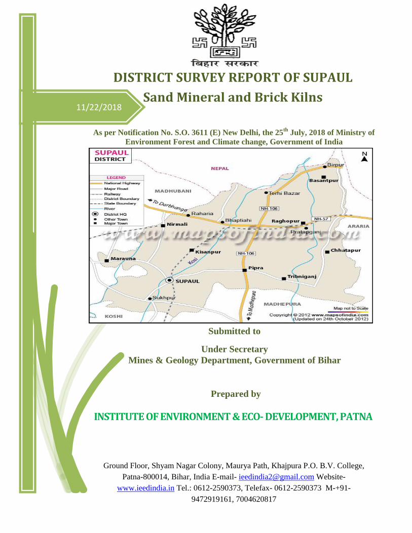
DISTRICT SURVEY REPORT OF SUPAUL
Sand Mineral and Brick Kilns
As per Notification No. S.O. 3611 (E) New Delhi, the 25th
July, 2018 of Ministry of
Environment Forest and Climate change, Government of India
Prepared by
INSTITUTE OF ENVIRONMENT & ECO- DEVELOPMENT, PATNA
Ground Floor, Shyam Nagar Colony, Maurya Path, Khajpura P.O. B.V. College,
Patna-800014, Bihar, India E-mail- [email protected] Website-
www.ieedindia.in Tel.: 0612-2590373, Telefax- 0612-2590373 M-+91-
9472919161, 7004620817
Submitted to
Under Secretary
Mines & Geology Department, Government of Bihar
DISTRICT SURVEY REPORT –SUPAUL -BIHAR Page 1
PREFACE
The Ministry of Environment, Forests & Climate Change (MoEF&CC), Government of India, made
Environmental Clearance (EC) for mining of minerals mandatory through its Notification of 27th
January, 1994 under the provisions of Environment Protection Act, 1986. Keeping in view the
experience gained in environmental clearance process over a period of one decade, the MoEF&CC
came out with Environmental Impact Notification, SO 1533 (E), dated 14th September 2006. Now
again Ministry of Environment, Forests & Climate Change (MoEF&CC), Government of India
amended the notification S.O. 141(E) Dated 15th
January, 2016 videS.O. 3611(E) Dated 25th
July, 2018. It has been made mandatory to obtain environmental clearance for different kinds of
development projects as listed in Appendix-X of the Notification.
Further, in pursuance to the order of Hon‟ble Supreme Court dated the 27th February, 2012 in I.A.
No.12- 13 of 2011 in Special Leave Petition (C) No.19628-19629 of 2009, in the matter of Deepak
Kumar etc. Vs. State of Haryana and Others etc., prior environmental clearance has now become
mandatory for mining of minor minerals irrespective of the area of mining lease; And also in view of
the Hon‟ble National Green Tribunal, order dated the 13th January, 2015 in the matter regarding sand
mining has directed for making a policy on environmental clearance for mining leases in cluster for
minor Minerals, The Ministry of Environment, Forest and Climate Change in consultation with State
governments has prepared Guidelines on Sustainable Sand Mining detailing the provisions on
environmental clearance for cluster, creation of District Environment Impact Assessment Authority
and proper monitoring of minor mineral mining using information technology and information
technology enabled services to track the mined out material from source to destination.
The DEIAA and DEAC will scrutinize and recommend the prior environmental clearance of mining
of minor minerals on the basis of District Survey Report. This will a model and guiding document
which is a compendium of available mineral resources, geographical set up, environmental and
ecological set up of the district and replenishment of minerals and is based on data of various
departments, published reports, journals and websites. The District Survey Report will form the basis
for application for environmental clearance, preparation of reports and appraisal of projects. The
Report will be updated once every five years.
DISTRICT SURVEY REPORT –SUPAUL -BIHAR Page 2
OBJECTIVES
The main objective of the preparation of District Survey Report (as per the Sustainable Sand
Mining Guideline) is to ensure the following –
Identification of mineral wealth in the district.
Identification of areas of aggradations or deposition where mining can be allowed;
and
Identification of areas of erosion and proximity to infrastructural structures and
installations where mining should be prohibited and calculation of annual rate of
replenishment and allowing time for replenishment after mining in that area.
DISTRICT SURVEY REPORT –SUPAUL -BIHAR Page 3
INDEX
Sl. No. Chapters Page No.
Chapter-1 Introduction 4
Chapter-2 Overview of Mining Activity in the District 13
Chapter-3 The List of Mining Leases in the District with location, area and
period of validity
16
Chapter-4 Details of Royalty or Revenue received from minor minerals in last
three years
17
Chapter-5 Detail of Production of Sand in last three years 18
Chapter-6 Process of Deposition of Sediments in the rivers of the District 19
Chapter-7 General Profile of the District 23
Chapter-8 Land Utilization Pattern in the district: Forest, Agriculture,
Horticulture, Mining etc.
25
Chapter-9 Physiography of the District 28
Chapter-10 Rainfall: month-wise 32
Chapter-11 Geology and Mineral Wealth
Drainage System with description of main rivers.
Salient Features of Important Rivers and Streams
35
Chapter-12 Status of Brick Kilns in Supaul district 43
References 44
Annexures
DISTRICT SURVEY REPORT –SUPAUL -BIHAR Page 4
CHAPTER-1
INTRODUCTION
As per Gazette Notification of 15th January, 2016 of Ministry of Environment, Forest and
Climate Change a survey shall be carried out by the District Environment Impact Assessment
Authority (DEIAA) with assistance of Irrigation department, Drainage department, Forest
department, Mining department and Revenue department in district of preparation of District
Survey Report as per the sustainable sand mining guidelines to ensure identification of are of
aggradations or deposition where mining can be allowed, and identification of areas of erosion
and proximity to infrastructural structures and installation where mining should be prohibited
and calculation of annual rate of replenishment and allowing time for replenishment after mining
in that area.
Every effort has been made to cover sand mining locations, areas and overviews of mining
activity in the district with all the relevant features pertaining to geology and mineral wealth in
replenishable and non-replenishable areas of rivers, stream and other sources. The mineral
potential is calculated based on field investigation taking coordinates of the area and gather all
relevant information and geology of the catchment area of the river or stream. Also gather all
data for bricks mining, taking area coordinates with local soil quality, availability of soil etc.
Also as per the site condition and location depth of mineable mineral is defined. The area of
removal of mineral in the river and stream is decided on geomorphology and other factors, it can
be 50% to 60% of the area of a particular river or stream. Similarly for bricks mining all data
gathered. Other constituents like clay and slit are excluded as waste while calculating the mineral
potential of particular river or stream. This District Survey Report shall form the basis of
application for environmental, preparation of reports and appraisal of projects. The report shall
be updated once every 5 years.

DISTRICT SURVEY REPORT –SUPAUL -BIHAR Page 5
Location, Area and Administrative Details:-
Supaul is situated at 25037'-26
025' N latitude and 86
022' – 87
010' E Longitude. It is one of the
thirty-eight Districts of Bihar.
The district is a part of the Kosi
division and covers an area of
2,420 sq km. The district was
carved out from the erstwhile
Saharsa district on 14 March
1991. Supaul town is the
administrative headquarters of
the district. The district is
bounded by Nepal in the north,
Saharsa in the south, by Araria
district in the East and on the
west by Madhubani district. The
district comprises 4 sub-
divisions: Supaul, Birpur,
Triveniganj and Nirmali. Supaul sub-division consists 4 blocks: Supaul, Kishanpur, Saraigadh-
Bhaptiyahi and Pipra. Birpur sub-division is further divided into 3 blocks: Basantpur, Raghopur
and Pratapganj. Triveniganj sub-division has 2 blocks, namely, Triveniganj and Chhatapur, and
Nirmali sub-division comprises 2 blocks, namely, Nirmali and Marauna. In 2011, Supaul had a
population of 2,229,076 of which male and female were 1,155,283 and 1,073,793 respectively.
There was change of 28.66 percent in the population compared to population as per 2001. The
initial provisional data released by census India 2011, shows that density of Supaul district for
2011 is 919 people per sq. km. In 2001, Supaul district density was at 714 people per sq. km.
Average literacy rate of Supaul in 2011 were 57.67 compared to 37.28 of 2001. If things are
looked out at gender wise, male and female literacy were 69.62 and 44.77 respectively. With
regards to Sex Ratio in Supaul, it stood at 929 per 1000 male compared to 2001 census figure of
920. Agriculture is the major occupation of this district and paddy is the main crop.
Topography:-
The topography of the district had been affected by the ravages of floods. After the construction
of Kosi Barrage and several embankments, the sandy tracts are being reclaimed the areas of
waste land, full of kans and pater (Jungles), lying mostly in Supaul district have been largely
reclaimed and are yielding crops. A number of canals have been constructed under the Kosi
projects which provide irrigational facilities to the districts of Supaul, Saharsa, Darbhanga,
Purnia and Madhepura besides some parts of Nepal.
DISTRICT SURVEY REPORT –SUPAUL -BIHAR Page 6
The entire district lies north of the Ganges and is comprised of planes. The eastern portion of the
district is more fertile and more densely populated. The deposits left by the turbulent Kosi have
affected the fertility of the soil but progressive implementation of the Kosi project has turned the
district into veritable granary.
Forest:-
There is no forest available in the district but there is a plan for planting various types of trees,
viz., Sisam, Eucalyptes, Gulmohar, Sakhua, etc., along the Kosi canal under the Forest Extension
Division, Purnia.
Basin/Sub-Basin and Drainage:-
The river Kosi flows through the western parts of the district and is considered as the sorrow of
not only this district, but for whole of the Bihar state. Tilyuga Chhaimra, Kali, Tilawe, Bhenga,
Mirchaiya, Sursar are the tributaries to it. The Kosi River, an important northern tributary of the
Ganga River, originates at an altitude of 7000 m above msl in the Tibet Himalayas and is the
third largest Himalayan River, after the Indus and the Brahmputra.
The Supaul district is located at the north eastern parts of Bihar state, which is situated in the
middle parts of Ganga Basin. The district falls in the Kosi Sub-basin. The river has remained
dynamic from historic parts and as such few palaeochannels of the river are traced in the district.
Mis-fit channels with significant drainage during monsoon flow across the district towards south.
The Kosi River has formed a megafan of ~13,000 km2 in Bihar state. The Supaul district is
situated at the northern parts of the mega fan.
The Kosi River and others such as Baghmati, Kamla-Balan and Adhwara group of rivers in the
northern Bihar plains are highly unstable due to steep slope and high rate of burial of the river-
beds with channel sediments, since the sediment load of these rivers is too high. They very often
create breaches in their embankments and inundate the adjoining low-lying areas, thereby
causing floods. The breach of left embankment of Kosi in 2008 took place at Kusaha, ~12 km
upstream from Bhimnagar in Supaul district. It was devastating for life and property.
Land use, Agriculture and Irrigation Practices:-
Agriculture is the main occupation of the people in Supaul district. In general, there are four
agricultural seasons in one year; (i) Bhadai (ii) Aghani (iii) Rabi & (iv) Garma. During Rabi the
important crops, which are grown in the district include wheat, rice, corn, mustard, jawar etc.
Paddy is mainly grown during June to November. The climate allows round the year vegetable
cultivation of cabbage, cauliflower, carrot, radish, chili, capsicum, beans and long beans, gourd,
potato, onion, coriander, turmeric, ginger, Garlic etc. The staple cereal of this district is rice.
DISTRICT SURVEY REPORT –SUPAUL -BIHAR Page 7
Irrigation plays a vital role in the agriculture in this district. Though, the district falls in the
eastern Kosi command area and a major part of the irrigation in the district is met from
groundwater. In summer, canal system remains dry. Again, due to very heavy siltation, capacity
of the canal reduces significantly. It is observed that groundwater forms a major irrigation source
in the district with more than 50 % of the net irrigated area getting the source from groundwater
(NIC-1997-98, Govt. of Bihar). The water level remains shallow and the people try to have their
own tube well in the agr-filed with a local design. Bamboo wells, constructed within a depth of
5-15 m are used locally. However, selling and buying of water for irrigation is a usual practice in
the district. Irrigation, In general farmers buy water for their crops from the neighbor. As on
2008-09, the net sown area in the district was at 1328 km2 with the average agriculture intensity
at 151%. The district possesses an area of 677 km2, which is sown more than once .

DISTRICT SURVEY REPORT –SUPAUL -BIHAR Page 8
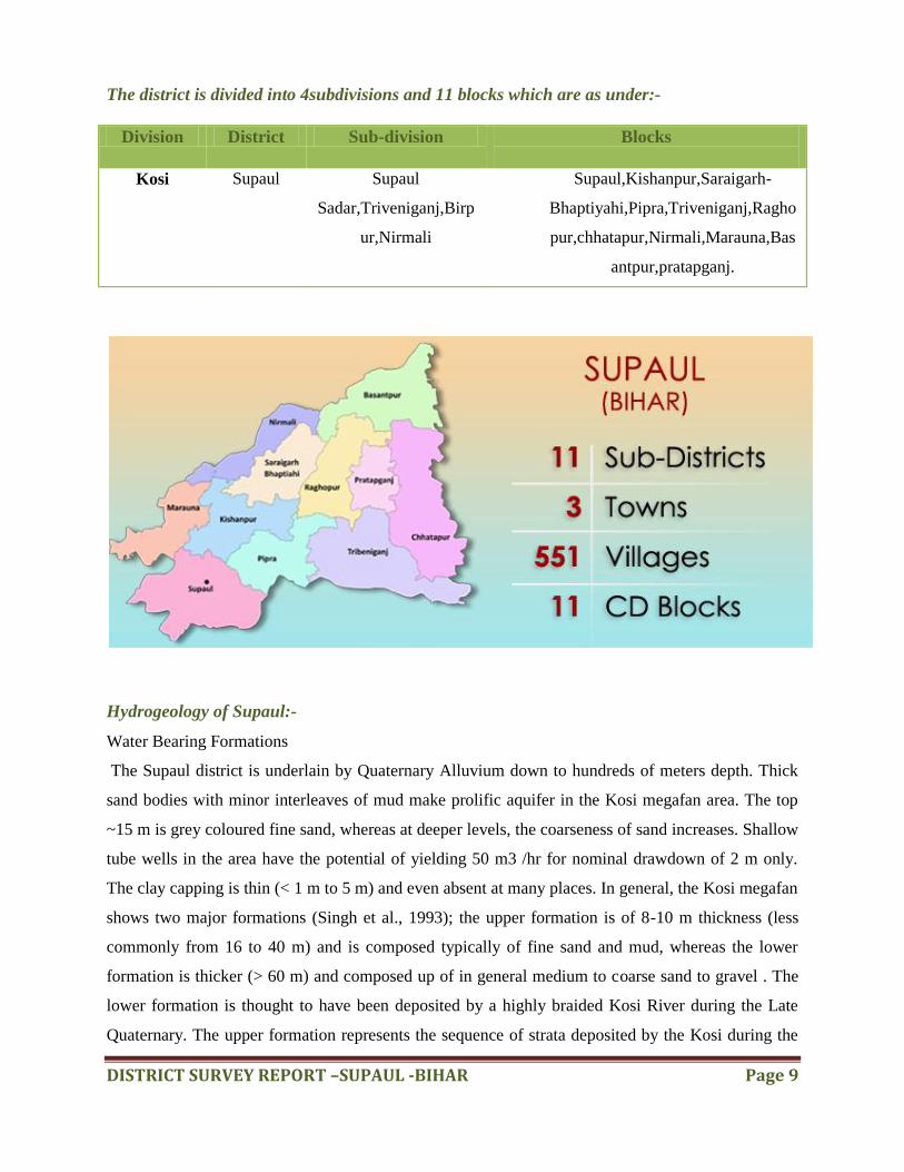
Location of Supaul district in the map of Bihar:-
DISTRICT SURVEY REPORT –SUPAUL -BIHAR Page 9
The district is divided into 4subdivisions and 11 blocks which are as under:-
Division District Sub-division Blocks
Kosi Supaul Supaul
Sadar,Triveniganj,Birp
ur,Nirmali
Supaul,Kishanpur,Saraigarh-
Bhaptiyahi,Pipra,Triveniganj,Ragho
pur,chhatapur,Nirmali,Marauna,Bas
antpur,pratapganj.
Hydrogeology of Supaul:-
Water Bearing Formations
The Supaul district is underlain by Quaternary Alluvium down to hundreds of meters depth. Thick
sand bodies with minor interleaves of mud make prolific aquifer in the Kosi megafan area. The top
~15 m is grey coloured fine sand, whereas at deeper levels, the coarseness of sand increases. Shallow
tube wells in the area have the potential of yielding 50 m3 /hr for nominal drawdown of 2 m only.
The clay capping is thin (< 1 m to 5 m) and even absent at many places. In general, the Kosi megafan
shows two major formations (Singh et al., 1993); the upper formation is of 8-10 m thickness (less
commonly from 16 to 40 m) and is composed typically of fine sand and mud, whereas the lower
formation is thicker (> 60 m) and composed up of in general medium to coarse sand to gravel . The
lower formation is thought to have been deposited by a highly braided Kosi River during the Late
Quaternary. The upper formation represents the sequence of strata deposited by the Kosi during the

DISTRICT SURVEY REPORT –SUPAUL -BIHAR Page 10
latest sweep across the megafan from east to west. The upper formation forms the younger Alluvium,
while the lower one is thought to belong to an older sequence.
Source: Centre for Ground Water Board (CGWB)
Climate and Rainfall:-
The area has warm and humid climate with high temperature and medium to high rainfall. The
temperatures are lowest during December-January with an average minimum of 80C to 100C and
maximum of 240C to 25
0C. The temperatures in the hottest months of April to June are minima 230C
to 250C and maxima 350C to 380C. The normal rainfall for the district stands at 1404 mm. Most of
the rainfall (80% to 90%) is received from mid-June to mid-October. The late September October
rains (locally known as „Hathia‟) are very crucial to agriculture in the region and their timing and
distribution make all the difference between plenty and scarcity. The last 18 years annual rainfall
data shows that the variation within the minimum of 669 mm (2006) to a maximum of 1794 mm
(1999). After the year 1999/2000, there has been an overall decrease in the annual rainfall.
Rivers:-
Kosi is the most important
river of the district. It rises
from the Himalayas. It is also
known as Sapt Kosi for its
seven upper tributaries. Its
three tributaries Sun Deosi,
Arun and Tamur meet at
Tribeni and form the Sapt
Kosi. It enters the plains at
Chatra. A number of rivers
such as the Tilguga, the
Bhuthhi Balan, the Sugarwe,
the Sonior, the Jangar Balan, the Kamla and the Bagmati join the Kosi on its right bank on the plain.
The Kosi is notorious for its vagaries and was known as Bihar‟s river of sorrow. During the rainy
season it swells and inundates large tracts of the district. It has changed its course a number of times
and at present it has shifted its course to the west and flows near Nirmali and Madhepur, the latter
being a part of Madhubani district. The other important rivers of the district emerge from the

DISTRICT SURVEY REPORT –SUPAUL -BIHAR Page 11
Himalayas and fall into the Khagari river which itself joins the Kosi. These rivers are the Tiljuga, the
Bati, the Dhimra, the Tilabe, the Parwan, the Dhusan, the Chalausi, the Loran, the Katna, the Daus
and the Ghagri.
Soils:-
The district in general possesses alluvial soil. The soils are of poorly drained type. The areas close to
the Kosi channels possess soil types of sandy loam, loamy sand and sand character, whereas, the
areas away from the river channels consist of silty sand to sandy silt in nature. The soils in general
are fine textured away from the river course and rivulets and coarse textured along their courses.
Source: Centre for Ground Water Board (CGWB)
Flora and Fauna:-
Paddy and wheat are grown in the alluvial and reclaimed soils the Kosi affected areas still contain
Kans and Pater forest, though reclamation is in progress. Small trees such as babul, jhaua, Harjora
etc., and water berries such as Makhana, Ramdana and Motha grass are also found, Sabai Grass,
Munj and varieties of cane etc., also grow in the district. Though the Kosi has destroyed a large
number of fruit bearing trees, the district still produces a large quantity of mangoes. Other common
trees are Mahua, Jackfruit, Plantain, tamarind, bair, Jamun and Kath jamun, Khajur, Sal, Sesum, and
Semal, Lichi, Guava, lemon watermelon,coconut and betelnut are also grown. The denudation of
forests, the reclamation of Kans and Pater infested waste-lands, and indiscriminate hunting in the
past have led to the decline of tiger, panther, hog-deer, chital, wildboar, etc., Nilgai, hares, and
Khikhir are still found. Jackals, monkeys, wolves are also common. Several deadly species of
reptiles such as cobra and karait and various kinds of lizards are also found. Jungle crow, house
crow, tree pie, crow peasant, grey hornbill, little brown dove, grey partridge, white breasted water
hen, bronze-winged jacana, curlew- stint black ibis, glossy ibis, white necked stork, cattle egret
pond heron, pink headed duck, silli or cotton teal, white fronted goose, large whistling teal,
brahminy duck, eastern grey duck, marbled teal and eastern goosander are the different varieties of
birds found in the district of Supaul. The reclamation of water pools and indiscriminate shooting
have led to the extinction of the pink-headed duck, marbled teal, copperbreasted teal and floricans.
Various species of ducks, mallard, nakta comb duck and geese are no longer found.
Connectivity: -
Supaul is well connected to the rest of the state and India by rail, road and air connections.
DISTRICT SURVEY REPORT –SUPAUL -BIHAR Page 12
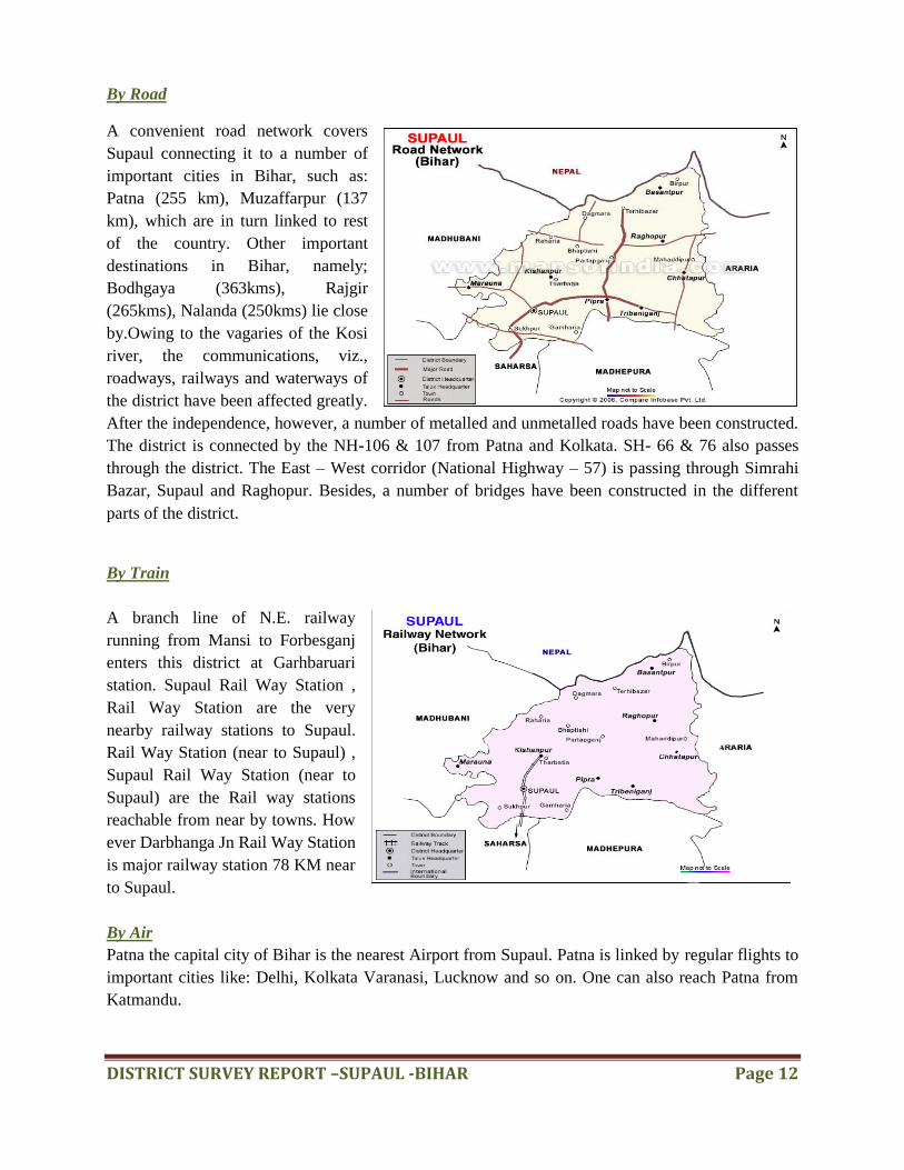
By Road
A convenient road network covers
Supaul connecting it to a number of
important cities in Bihar, such as:
Patna (255 km), Muzaffarpur (137
km), which are in turn linked to rest
of the country. Other important
destinations in Bihar, namely;
Bodhgaya (363kms), Rajgir
(265kms), Nalanda (250kms) lie close
by.Owing to the vagaries of the Kosi
river, the communications, viz.,
roadways, railways and waterways of
the district have been affected greatly.
After the independence, however, a number of metalled and unmetalled roads have been constructed.
The district is connected by the NH-106 & 107 from Patna and Kolkata. SH- 66 & 76 also passes
through the district. The East – West corridor (National Highway – 57) is passing through Simrahi
Bazar, Supaul and Raghopur. Besides, a number of bridges have been constructed in the different
parts of the district.
By Train
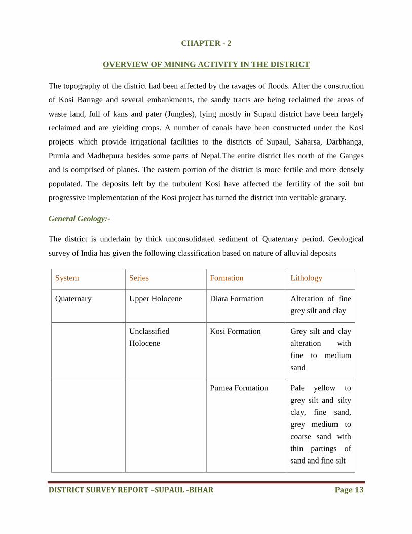
A branch line of N.E. railway
running from Mansi to Forbesganj
enters this district at Garhbaruari
station. Supaul Rail Way Station ,
Rail Way Station are the very
nearby railway stations to Supaul.
Rail Way Station (near to Supaul) ,
Supaul Rail Way Station (near to
Supaul) are the Rail way stations
reachable from near by towns. How
ever Darbhanga Jn Rail Way Station
is major railway station 78 KM near
to Supaul.
By Air
Patna the capital city of Bihar is the nearest Airport from Supaul. Patna is linked by regular flights to
important cities like: Delhi, Kolkata Varanasi, Lucknow and so on. One can also reach Patna from
Katmandu.
DISTRICT SURVEY REPORT –SUPAUL -BIHAR Page 13
CHAPTER - 2
OVERVIEW OF MINING ACTIVITY IN THE DISTRICT
The topography of the district had been affected by the ravages of floods. After the construction
of Kosi Barrage and several embankments, the sandy tracts are being reclaimed the areas of
waste land, full of kans and pater (Jungles), lying mostly in Supaul district have been largely
reclaimed and are yielding crops. A number of canals have been constructed under the Kosi
projects which provide irrigational facilities to the districts of Supaul, Saharsa, Darbhanga,
Purnia and Madhepura besides some parts of Nepal.The entire district lies north of the Ganges
and is comprised of planes. The eastern portion of the district is more fertile and more densely
populated. The deposits left by the turbulent Kosi have affected the fertility of the soil but
progressive implementation of the Kosi project has turned the district into veritable granary.
General Geology:-
The district is underlain by thick unconsolidated sediment of Quaternary period. Geological
survey of India has given the following classification based on nature of alluvial deposits
System Series Formation Lithology
Quaternary Upper Holocene Diara Formation Alteration of fine
grey silt and clay
Unclassified
Holocene
Kosi Formation Grey silt and clay
alteration with
fine to medium
sand
Purnea Formation Pale yellow to
grey silt and silty
clay, fine sand,
grey medium to
coarse sand with
thin partings of
sand and fine silt

DISTRICT SURVEY REPORT –SUPAUL -BIHAR Page 14
Availability of Mineral resources:-
The mineral resources of Supaul district playing massive role in social and economic development of
the district.
Available mineral resources in the district:-
Sand
clay
Approach to Sand Mining:-
River sand mining is a common practice as habitation concentrates along the rivers and the
mining locations are preferred near the markets or along the transportation route, for reducing the
transportation cost. River sand mining can damage private and public properties as well as
aquatic habitats. Excessive removal of sand may significantly distort the natural equilibrium of a
stream channel.
Main objectives of Sustainable Sand Mining:-
To ensure that sand and gravel mining is done in environmentally sustainable and
socially responsible manner.
To ensure availability of adequate quantity of aggregate in sustainable manner.
To improve the effectiveness of monitoring of mining and transportation of mined out
material:
Ensure conservation of the river equilibrium and its natural environment by protection
and restoration of the ecological system.
Avoid aggradations at the downstream reach especially those with hydraulic structures
such as jetties, water intakes etc.
Ensure that the rivers are protected from bank and bed erosion beyond its stable profile.
No obstruction to the river flow, water transport and restoring the riparian rights and in
stream habitats.
Avoid pollution of river water leading to water quality deterioration.
To prevent depletion of ground water reserves due to excessive draining out of ground
water.
DISTRICT SURVEY REPORT –SUPAUL -BIHAR Page 15
To prevent ground water pollution by prohibiting sand mining on fissures where it works
as filter prior to ground water recharge.
To maintain the river equilibrium with the application of sediment transport principles in
determining the locations, period and quantity to be extracted
Streamlining and simplifying the process for grant of environmental clearance (EC) for
sustainable mining.

DISTRICT SURVEY REPORT –SUPAUL -BIHAR Page 16
CHAPTER - 3
LIST OF MINING LEASES IN THE DISTRICT WITH LOCATION, AREA AND
PERIOD OF VALIDITY
List of Mining Leases in the District with location, area and period of validity is attached as
Annexure-1
Sl. Mining Unit
Area Per
Name Name of Granted
Annual Present Status
No. Block (In iod Of of Minerals Capacity
Location Hect.) (In Minor
Concession as per E.C.
Yrs
Mineral
/Mining
) s Plants/To
r in lakh
MT.
1 Dagmara 2.00 5 Sand Shri Upendra Prasad
91800 This Sand Ghat
Lalman Patti
Singh, S/o- Late Shri
Lease area is mining
Ghat ram Pramod Singh,
condition now.
(Koshi River)
ward no – 12,
Nirmali, P.O+ P.s-
Nirmali, Supaul.
2 Dina Patti 2.00 5 Sand Do 91800 This Sand Ghat
Ghat Lease area is mining
(Parwana condition now.
River)
3 Lachhminiya
0.8 5 Sand DO 36720 This Sand Ghat
Ghat Lease Area is Fail
(Saptgandhi
now. Because A and
River) B coordinates is
beside of river and C
and D
DISTRICT SURVEY REPORT –SUPAUL -BIHAR Page 17
coordinates is out of river.
And River Water is
Flow
in the Center.
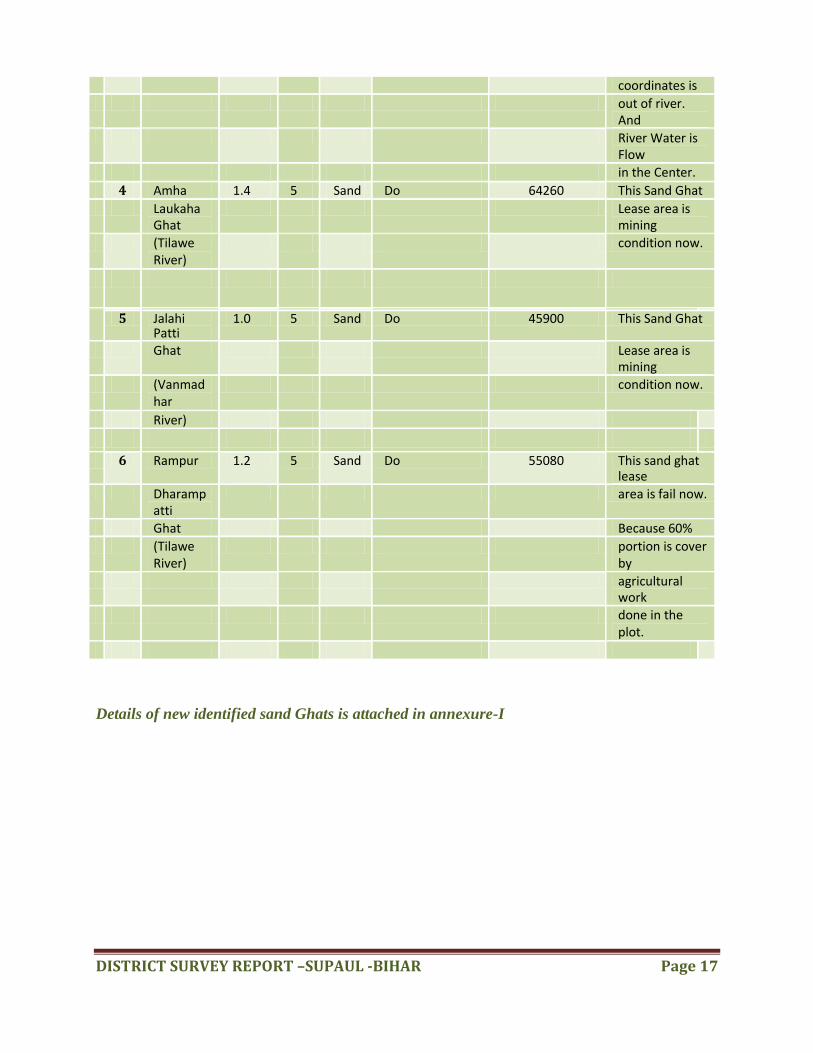
4 Amha 1.4 5 Sand Do 64260 This Sand Ghat Laukaha
Ghat Lease area is
mining
(Tilawe River)
condition now.
5 Jalahi Patti
1.0 5 Sand Do 45900 This Sand Ghat
Ghat Lease area is mining
(Vanmadhar
condition now.
River)
6 Rampur 1.2 5 Sand Do 55080 This sand ghat lease
Dharampatti
area is fail now.
Ghat Because 60%
(Tilawe River)
portion is cover by
agricultural work
done in the plot.
Details of new identified sand Ghats is attached in annexure-I
DISTRICT SURVEY REPORT –SUPAUL -BIHAR Page 18
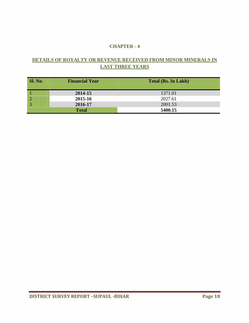
CHAPTER - 4
DETAILS OF ROYALTY OR REVENUE RECEIVED FROM MINOR MINERALS IN
LAST THREE YEARS
Sl. No. Financial Year Total (Rs. In Lakh)
1 2014-15 1371.01
2 2015-16 2027.61
3 2016-17 2001.53
Total 5400.15
DISTRICT SURVEY REPORT –SUPAUL -BIHAR Page 19
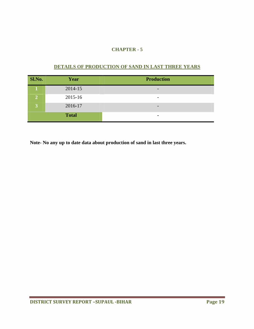
CHAPTER - 5
DETAILS OF PRODUCTION OF SAND IN LAST THREE YEARS
Sl.No. Year Production
1 2014-15 -
2 2015-16 -
3 2016-17 -
Total -
Note- No any up to date data about production of sand in last three years.
DISTRICT SURVEY REPORT –SUPAUL -BIHAR Page 20
CHAPTER - 6
PROCESS OF DEPOSITION OF SEDIMENTS IN THE RIVERS OF THE DISTRICT
PROCESS:-
Sediment is a naturally occurring material that is broken down by processes of weathering and
erosion, and is subsequently transported by the action of wind, water and/or by the force of
gravity acting on the particles. Sediments are most often transported by water. Sediment is
transported based on the strength of the flow that carries it and its own size, volume, density, and
shape. Stronger flows will increase the lift and drag on the particle, causing it to rise, while larger
or denser particles will be more likely to fall through the flow.
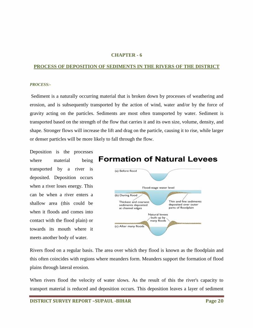
Deposition is the processes
where material being
transported by a river is
deposited. Deposition occurs
when a river loses energy. This
can be when a river enters a
shallow area (this could be
when it floods and comes into
contact with the flood plain) or
towards its mouth where it
meets another body of water.
Rivers flood on a regular basis. The area over which they flood is known as the floodplain and
this often coincides with regions where meanders form. Meanders support the formation of flood
plains through lateral erosion.
When rivers flood the velocity of water slows. As the result of this the river's capacity to
transport material is reduced and deposition occurs. This deposition leaves a layer of sediment
DISTRICT SURVEY REPORT –SUPAUL -BIHAR Page 21
across the whole floodplain. After a series of floods layers of sediment form along the flood
plain.
Larger material and the majority of deposition occur next to the river channel. This is the result
of increased friction (with the flood plain) causing the velocity of the river to slow and therefore
rapidly reduce its ability to transport material. This leaves a ridge of higher material next to the
river channel on both banks of the river known as a levee.
If the upwards velocity approximately equal to the settling velocity, sediment will be transported
Downstream entirely as suspended load. If the upwards velocity is much less than the settling
velocity, but still high enough for the sediment to move, it will move along the bed as bed load
by rolling, sliding, and saltating (jumping up into the flow, being transported a short distance
then settling again). If the upwards velocity is higher than the settling velocity, the sediment will
be transported high in the flow as wash load.
As there are generally a range of different particle sizes in the flow, it is common for material of
different sizes to move through all areas of the flow for given stream conditions.
The various factors governing the occurrence and deposition of sand is country rock i.e.
geological disposition, climate, and rainfall, water load physical parameters of river and velocity
of water current. Rivers have a lot of energy and because they have energy, they do stuff. The
obvious things rivers do with their energy is flow but, besides this, they also transport load, erode
load and erode the channel through which they flow. Erosion is the breaking down of material by
an agent. In the case of a river, the agent is water. The water can erode the river‟s channel and
the river‟s load. A river‟s load is bits of eroded material, generally rocks, which the river
transports until it deposits its load.
Capacity & Competence Rivers can only carry so many loads depending on their energy. The
maximum volume of load that a river can carry at a specific point in its course is called the age
river‟s capacity. The biggest sized particle that a river could carry at a specific point is called the
river‟s competence. Deposition to transport load a river needs to have energy so when a river
loses energy it is forced to deposit its load. There are several reasons why a river could lose
energy. If the river‟s discharge is reduced then the river will lose energy because it isn‟t flowing
DISTRICT SURVEY REPORT –SUPAUL -BIHAR Page 22
as quickly anymore. This could happen because of a lack of precipitation or an increase in
evaporation. Increased human use (abstraction) of a river could also reduce its discharge forcing
It deposits its load. If the gradient of the river‟s course flattens out, the river will deposit its load
because it will be travelling a lot slower. When a river meets the sea a river will deposit its load
because the gradient is generally reduced at sea level and the sea will absorb a lot of energy. As
rivers get nearer to their mouths they flow in increasingly wide, gentle sided valleys. The
channel increases in size to hold the extra water which the river has to receive from its
tributaries. As the river gets bigger it can carry larger amounts of material. This material will be
small in size, as larger rocks will have broken up on their way from the mountains. Much of the
material will be carried in suspension and will erode the river banks by abrasion. When rivers
flow over flatter land, they develop large bends called meanders. As a river goes around a bend
most of the water is pushed towards the outside causing increased erosion. The river is now
eroding sideways into its banks rather than downwards into its bed, a process called lateral
erosion. On the inside of the bend, in contrast, there is much less water. The river will therefore
be shallow and slow-flowing. It cannot carry as much material and so sand and shingle will be
deposited.
This is called a point bar or slip off slope Due to erosion on the outside of a bend and deposition
on the inside, the shape of a meander will change over a period of time. Notice how erosion
narrows the neck of the land within the meander. In time, and usually during a flood, the river
will cut right through the neck. The river will then take the new, shorter route. The fastest
current, called the thalweg, will now tend to be in the centre of the river, and so deposition is
likely to occur in gentler water next to the banks. Eventually deposition will block off the old
meander to leave an oxbow lake. The oxbow lake will slowly dry up, only refilling after heavy
rain or during a flood. Streams lose velocity and make deposits when their gradient decreases,
when the volume of water decreases, when there is an increase in cross section, when they
encounter obstructions, or when they enter still water. They deposit alluvial fans, alluvial cones,
piedmont alluvial plains, channel fill, bars, flood plains and deltas.
Rivers in the Gangetic plains have a habit of meandering, i.e., changing course. In India this is a
prominent feature of rivers which swell in the monsoon, occasionally suddenly, and the torrential
movement carves out a new course in the soft alluvial plain. The Ganga River, in Patna, has
DISTRICT SURVEY REPORT –SUPAUL -BIHAR Page 23
meandered and migrated northwards in the Patliputra area. This migration has resulted in
deposition of earth on the south [right] bank of the river and created a massive space of a few
hundred hectares between the urban development line and the active river channel.
A river system can be divided into three subsystems:-
Collecting system (branches) -- consisting of a network of tributaries in the headwater
region, collects and funnels water and sediment to the main stream.
Transporting system (trunk) -- the main trunk stream, which functions as a channel way
through which water and sediment move from the collecting area toward the ocean.
(Erosion and deposition also occur in a river's transporting system)
Dispersing system (roots) -- consists of a network of distributaries at the mouth of a river
(delta), where sediment and water are dispersed into an ocean, a lake, or a dry basin
Removal of washed in Silt Load:-
Geologically, the district forms part of the vast Indo-Gangetic alluvial tract. The origin of the
Indo -`Gangetic tract as a whole is now attributed to the sag in the earth crust formed in the
upper Eocene times between Gondwana land and the raising of Himalaya belt. The economic
minerals found in the district are Sand, Soil and Kankar.
The sand deposits being an integral part of the dynamic river system to which it belongs.
Therefore, as a part of natural cycle, the monsoon flow of every river carries with it
replenishment of silt and washed out soil and clay from upstream areas in the catchment. This
silt shall be removed during the sieving of sand before it is loaded into truck/tipper/trailer to
carry to the consumers.
Sand mining is critical to infrastructure development around the globe. Sand is an essential
minor mineral used extensively across the country as a useful construction constituent and
variety of other uses in sports, agriculture, glass making (a form of sand with high silica content)
etc. The rivers are the most important source of Sand. It acts as source of transportation and
deposition of sand etc.
DISTRICT SURVEY REPORT –SUPAUL -BIHAR Page 24
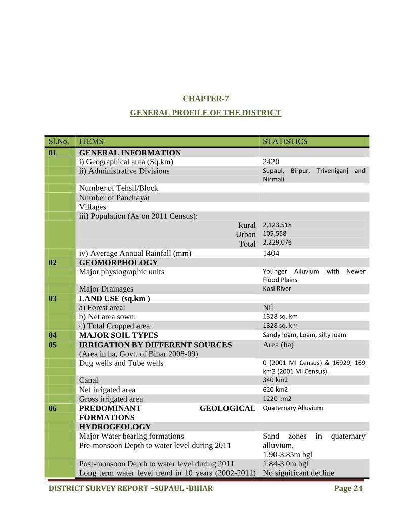
CHAPTER-7
GENERAL PROFILE OF THE DISTRICT
Sl.No. ITEMS STATISTICS
01 GENERAL INFORMATION
i) Geographical area (Sq.km) 2420
ii) Administrative Divisions Supaul, Birpur, Triveniganj and Nirmali
Number of Tehsil/Block
Number of Panchayat
Villages
iii) Population (As on 2011 Census):
Rural
Urban
Total
2,123,518 105,558 2,229,076
iv) Average Annual Rainfall (mm) 1404
02 GEOMORPHOLOGY
Major physiographic units Younger Alluvium with Newer Flood Plains
Major Drainages Kosi River
03 LAND USE (sq.km )
a) Forest area: Nil
b) Net area sown: 1328 sq. km
c) Total Cropped area: 1328 sq. km
04 MAJOR SOIL TYPES Sandy loam, Loam, silty loam
05 IRRIGATION BY DIFFERENT SOURCES
(Area in ha, Govt. of Bihar 2008-09)
Area (ha)
Dug wells and Tube wells 0 (2001 MI Census) & 16929, 169 km2 (2001 MI Census).
Canal 340 km2
Net irrigated area 620 km2
Gross irrigated area 1220 km2
06 PREDOMINANT GEOLOGICAL
FORMATIONS
Quaternary Alluvium
HYDROGEOLOGY
Major Water bearing formations
Pre-monsoon Depth to water level during 2011
Sand zones in quaternary
alluvium,
1.90-3.85m bgl
Post-monsoon Depth to water level during 2011
Long term water level trend in 10 years (2002-2011)
1.84-3.0m bgl
No significant decline

DISTRICT SURVEY REPORT –SUPAUL -BIHAR Page 25
in m/yr
07 GROUND WATER EXPLORATION BY CGWB
(As on 31.03.2013)
No. of wells drilled (EW, OW, PZ, SH = Total) Nil
Depth Range (m) -
Discharge -
Storativity (S) -
Transmissivity (m2/day) -
08 GROUND WATER QUALITY Fresh and potable
Presence of Chemical constituents more than
permissible limit (e.g., EC, F, As, F )
Iron
09 DYNAMIC GROUND WATER RESOURCES (as
on 31st March 2009) – in mcm
Annual Replenishable Ground Water Resources 82365 ha.m
Net Annual Ground Water Draft 24726 ha.m
Projected Demand for Domestic and Industrial Uses
upto 2025
5391 ha.m
Stage of Ground Water Development 32.2%
10 MINING SCENARIO
Total No. Mining Leases (Major Minerals) -
Total Area of Mining Leases (Major Minerals) -
Total Number of Quarry Lease (Minor Minerals) -
Total area of Quarry Lease -
Total Roylty or Revenue Received from Minor
Minerals in 2015-2016
-
Total No. Notified Sand Lease -
Total Area of sand Lease -
11 BRICK KILNS -
Total no. of Brick Kilns 109
Source: Centre for Ground Water Board (CGWB)

DISTRICT SURVEY REPORT –SUPAUL -BIHAR Page 26
DISTRICT SURVEY REPORT –SUPAUL -BIHAR Page 27
CHAPTER-8
LAND UTILIZATION PATTERN IN THE DISTRICT: FOREST, AGRICULTURE,
HORTICULTURE, MINING
Forest:-
There is no forest available in the
district but there is a plan for planting
various types of trees, viz., Sisam,
Eucalyptes, Gulmohar, Sakhua, etc.,
along the Kosi canal under the Forest
Extension Division, Purnia.
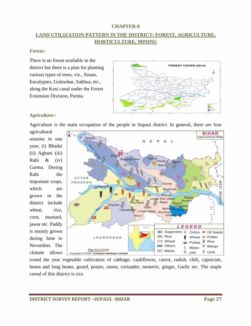
Agriculture:-
Agriculture is the main occupation of the people in Supaul district. In general, there are four
agricultural
seasons in one
year; (i) Bhadai
(ii) Aghani (iii)
Rabi & (iv)
Garma. During
Rabi the
important crops,
which are
grown in the
district include
wheat, rice,
corn, mustard,
jawar etc. Paddy
is mainly grown
during June to
November. The
climate allows
round the year vegetable cultivation of cabbage, cauliflower, carrot, radish, chili, capsicum,
beans and long beans, gourd, potato, onion, coriander, turmeric, ginger, Garlic etc. The staple
cereal of this district is rice.
DISTRICT SURVEY REPORT –SUPAUL -BIHAR Page 28
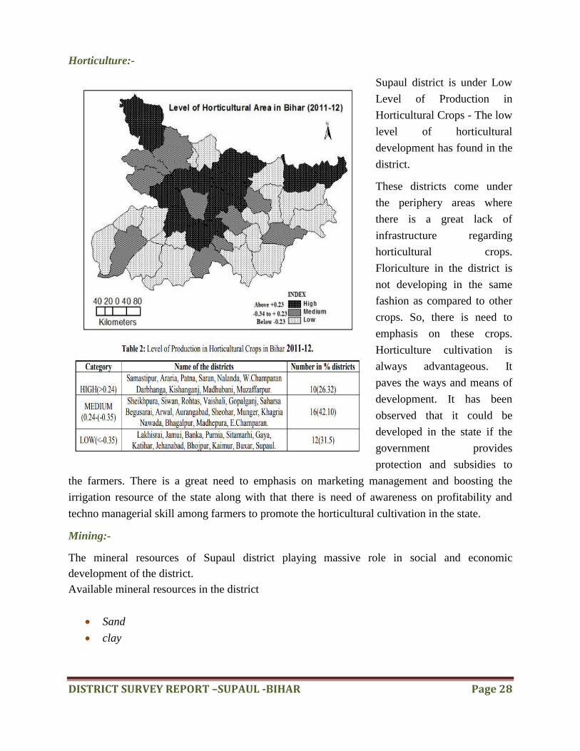
Horticulture:-
Supaul district is under Low
Level of Production in
Horticultural Crops - The low
level of horticultural
development has found in the
district.
These districts come under
the periphery areas where
there is a great lack of
infrastructure regarding
horticultural crops.
Floriculture in the district is
not developing in the same
fashion as compared to other
crops. So, there is need to
emphasis on these crops.
Horticulture cultivation is
always advantageous. It
paves the ways and means of
development. It has been
observed that it could be
developed in the state if the
government provides
protection and subsidies to
the farmers. There is a great need to emphasis on marketing management and boosting the
irrigation resource of the state along with that there is need of awareness on profitability and
techno managerial skill among farmers to promote the horticultural cultivation in the state.
Mining:-
The mineral resources of Supaul district playing massive role in social and economic
development of the district.
Available mineral resources in the district
Sand
clay
DISTRICT SURVEY REPORT –SUPAUL -BIHAR Page 29
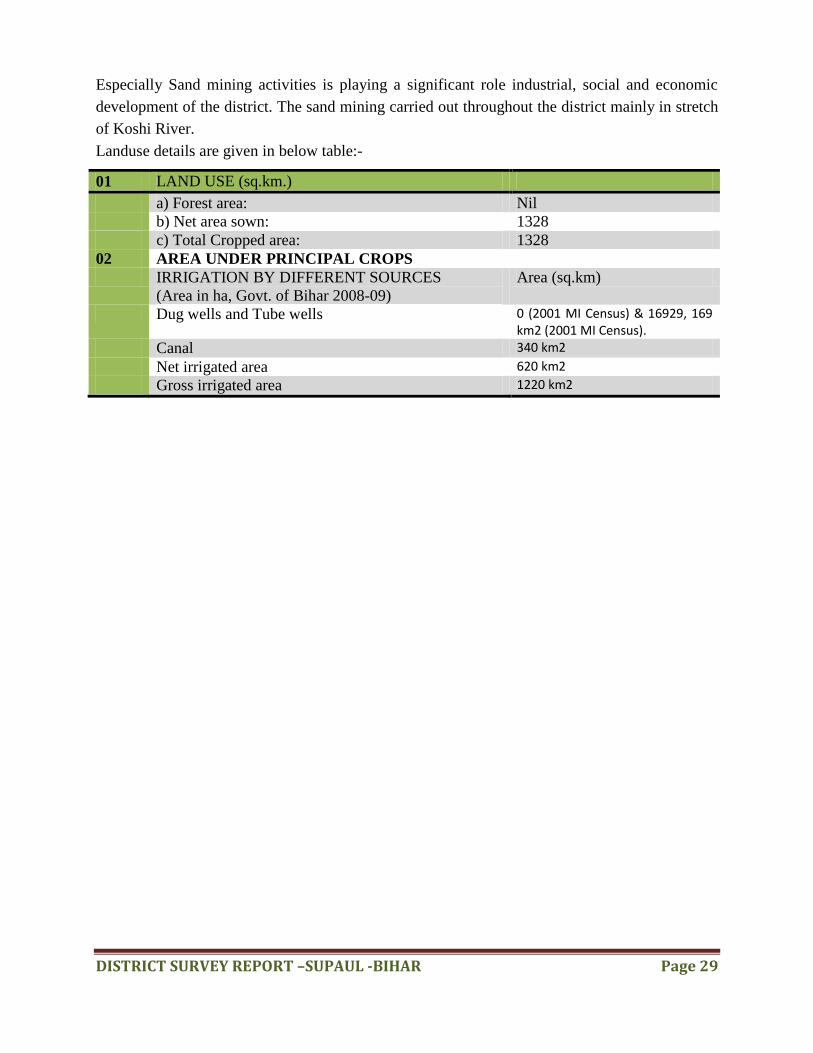
Especially Sand mining activities is playing a significant role industrial, social and economic
development of the district. The sand mining carried out throughout the district mainly in stretch
of Koshi River.
Landuse details are given in below table:-
01 LAND USE (sq.km.)
a) Forest area: Nil
b) Net area sown: 1328
c) Total Cropped area: 1328
02 AREA UNDER PRINCIPAL CROPS
IRRIGATION BY DIFFERENT SOURCES
(Area in ha, Govt. of Bihar 2008-09)
Area (sq.km)
Dug wells and Tube wells 0 (2001 MI Census) & 16929, 169 km2 (2001 MI Census).
Canal 340 km2
Net irrigated area 620 km2
Gross irrigated area 1220 km2

DISTRICT SURVEY REPORT –SUPAUL -BIHAR Page 30
CHAPTER-9
PHYSIOGRAPHY OF THE DISTRICT
The Bihar state can be broadly subdivided into three major unit‟s i.e., main physical sub-
divisions is the Norhern Mountains, the Gangetic Plains and the Central Highlands.
Northern Mountains comprises the Himalayan ranges including their foot hills. The
Gangetic plains, situated between the Himalayas and the Deccan plateau,constitute the
most fertile plains of the sub-basin ideally suited for intensive cultivation.The Central
highlands lying to the south of the Great plains consists of mountains, hills and plateaus
intersected by valleys and river plains.They are largely covered by forests.Aravali
uplands, Bundelkhand upland, Malwa plateau, Vindhyan and Narmada valley lie in the
this region.Predominant soil types found in the sub- basin are sandy, loamy , clay and
their combinations such as sandy loam , loam , silty clay loam and loamy sand soils.
PHYSIOGRAPHY MAP OF THE BIHAR
DISTRICT SURVEY REPORT –SUPAUL -BIHAR Page 31
Geomorphology:-
The district forms a part of the Kosi megafan. The river is known for its notorious shifting and
channel abandonment approximately in every 25 years. The district Supaul is subjected to
frequent flooding related to either shifting of the river Kosi or bank over-topping/breaching by
floodwater.
Sweeping of the river in the megafan has created the alluvial landscape with abandoned channels
and the flood plains. The abandoned channels exhibit sand bodies of huge dimension, often
exposed or buried under thin veneers (~1.0 m) of mud. They also characterize the depressions in
the megafan surface, which are prone to water-logging. Often the channels are occupied by mis-
fit channels of smaller dimension . During lean period, these channels get water from the
aquifers. These smaller channels rework and redistribute the flood plain sediments, and hence
contribute in the evolution of the flood plain architecture. The land surface in the district slopes
southward with 30-35 cm/km at the northern half, while it is 45-55 cm/km at the southern half
with an average value of ~ 40 cm/km. The reach segment of the Kosi River within the district
Supaul is wide (6 to 8 km) and highly braided in nature.
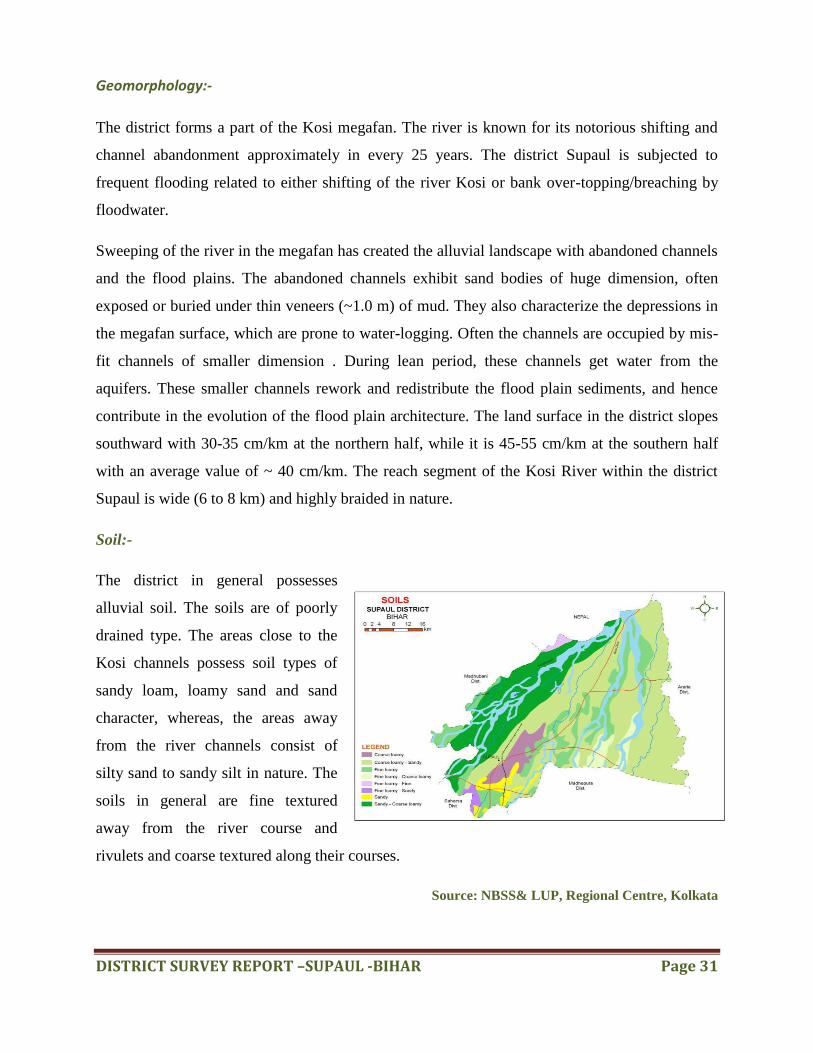
Soil:-
The district in general possesses
alluvial soil. The soils are of poorly
drained type. The areas close to the
Kosi channels possess soil types of
sandy loam, loamy sand and sand
character, whereas, the areas away
from the river channels consist of
silty sand to sandy silt in nature. The
soils in general are fine textured
away from the river course and
rivulets and coarse textured along their courses.
Source: NBSS& LUP, Regional Centre, Kolkata

DISTRICT SURVEY REPORT –SUPAUL -BIHAR Page 32
Natural divisions:-
The entire district lies north of the Ganges and is comprised of planes. The eastern portion of the
district is more fertile and more densely populated. The deposits left by the turbulent Kosi have
affected the fertility of the soil but progressive implementation of the Kosi project has turned the
district into veritable granary. The topography of the district had been affected by the ravages of
floods. After the construction of Kosi Barrage and several embankments, the sandy tracts are
being reclaimed the areas of waste land, full of kans and pater (Jungles), lying mostly in Supaul
district have been largely reclaimed and are yielding crops. A number of canals have been
constructed under the Kosi project which provides irrigational facilities to the districts of Supaul,
Saharsa, Darbhanga, Purnia and Madhepura besides some parts of Nepal.
Rivers:-
Kosi is the most important river of the district. It rises from the Himalayas. It is also known as
Sapt Kosi for its seven upper tributaries. Its three tributaries Sun Deosi, Arun and Tamur meet at
Tribeni and form the Sapt Kosi. It enters the plains at Chatra. A number of rivers such as the
Tilguga, the Bhuthhi
Balan, the Sugarwe, the
Sonior, the Jangar
Balan, the Kamla and
the Bagmati join the
Kosi on its right bank
on the plain. The Kosi
is notorious for its
vagaries and was
known as Bihar‟s river
of sorrow. During the
rainy season it swells
and inundates large tracts of the district. It has changed its course a number of times and at
present it has shifted its course to the west and flows near Nirmali and Madhepur, the latter being
a part of Madhubani district. The other important rivers of the district emerge from the
Himalayas and fall into the Khagari river which itself joins the Kosi. These rivers are the Tiljuga,
DISTRICT SURVEY REPORT –SUPAUL -BIHAR Page 33
the Bati, the Dhimra, the Tilabe, the Parwan, the Dhusan, the Chalausi, the Loran, the Katna, the
Daus and the Ghagri.
CHAPTER-10
RAINFALL: MONTH-WISE
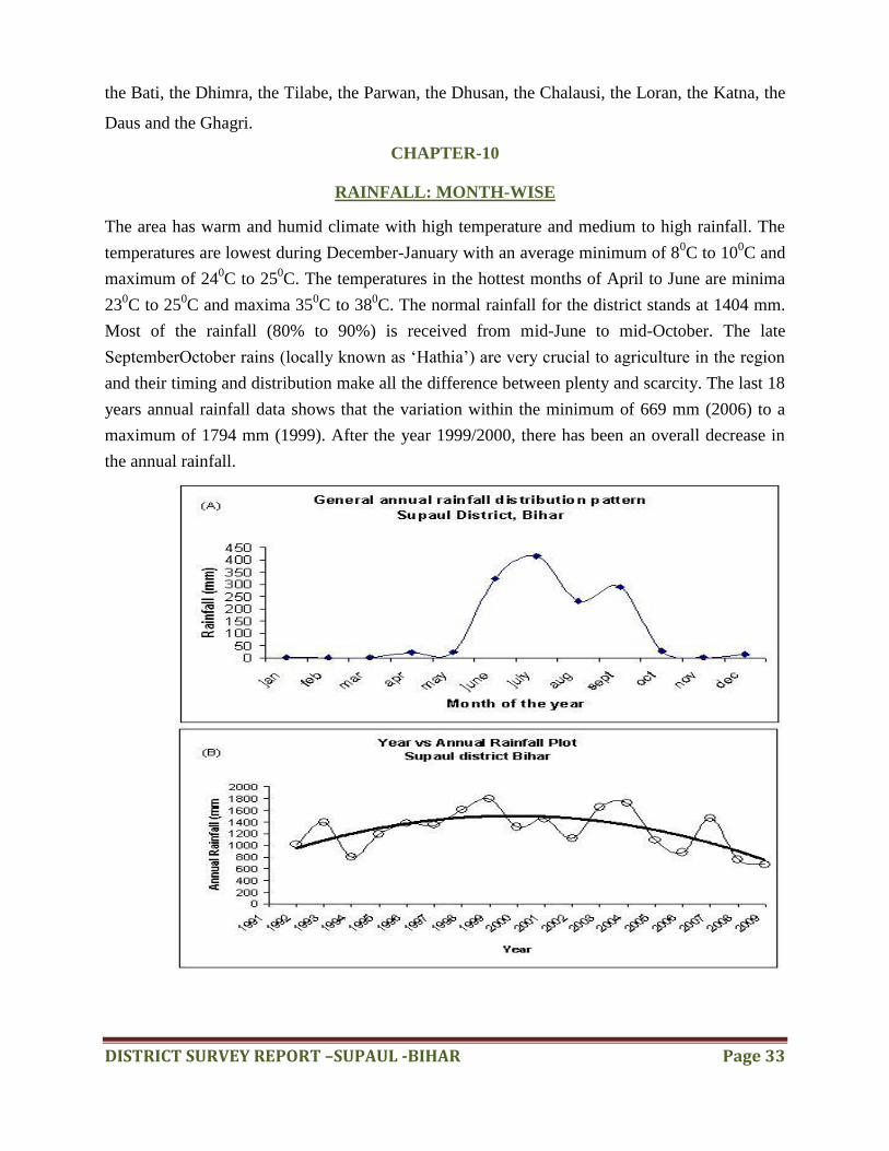
The area has warm and humid climate with high temperature and medium to high rainfall. The
temperatures are lowest during December-January with an average minimum of 80C to 10
0C and
maximum of 240C to 25
0C. The temperatures in the hottest months of April to June are minima
230C to 25
0C and maxima 35
0C to 38
0C. The normal rainfall for the district stands at 1404 mm.
Most of the rainfall (80% to 90%) is received from mid-June to mid-October. The late
SeptemberOctober rains (locally known as „Hathia‟) are very crucial to agriculture in the region
and their timing and distribution make all the difference between plenty and scarcity. The last 18
years annual rainfall data shows that the variation within the minimum of 669 mm (2006) to a
maximum of 1794 mm (1999). After the year 1999/2000, there has been an overall decrease in
the annual rainfall.
DISTRICT SURVEY REPORT –SUPAUL -BIHAR Page 34
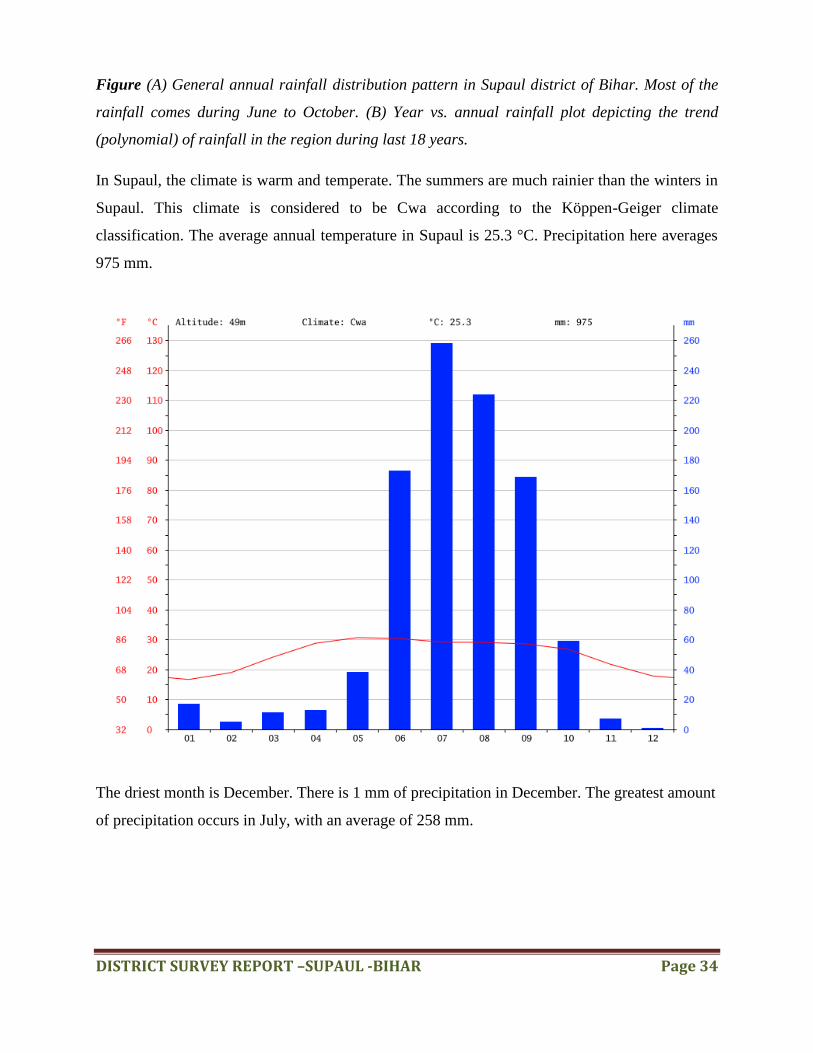
Figure (A) General annual rainfall distribution pattern in Supaul district of Bihar. Most of the
rainfall comes during June to October. (B) Year vs. annual rainfall plot depicting the trend
(polynomial) of rainfall in the region during last 18 years.
In Supaul, the climate is warm and temperate. The summers are much rainier than the winters in
Supaul. This climate is considered to be Cwa according to the Köppen-Geiger climate
classification. The average annual temperature in Supaul is 25.3 °C. Precipitation here averages
975 mm.
The driest month is December. There is 1 mm of precipitation in December. The greatest amount
of precipitation occurs in July, with an average of 258 mm.
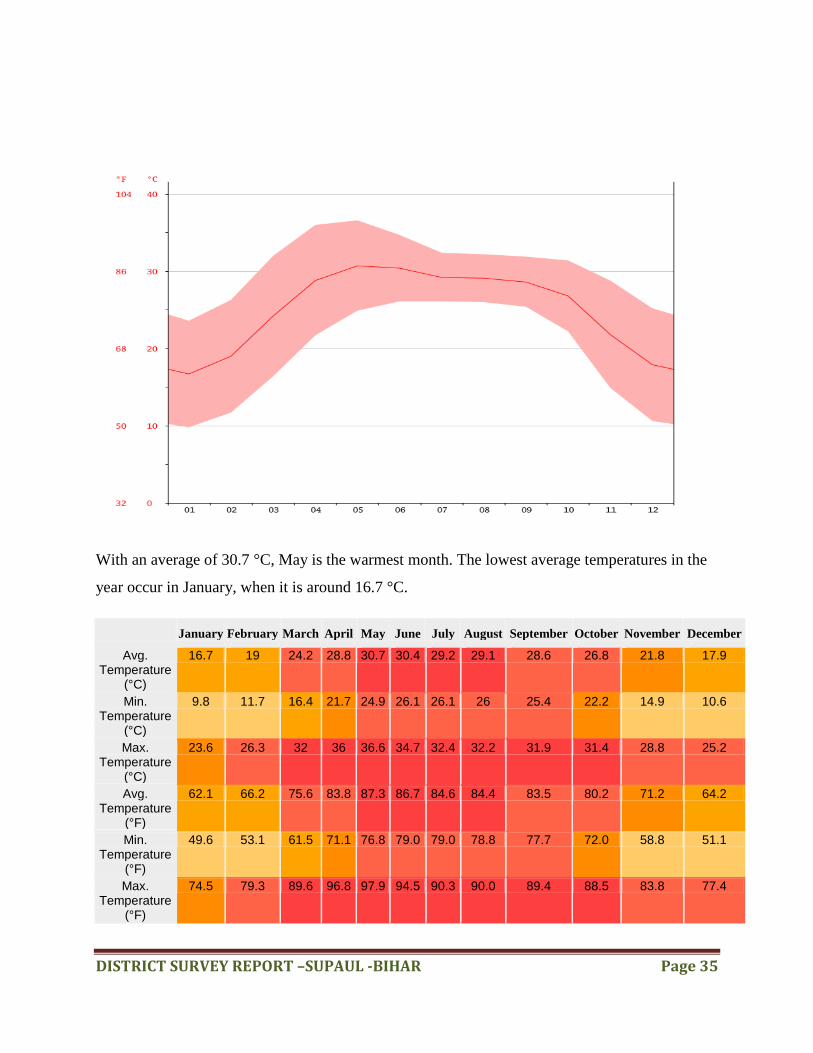
DISTRICT SURVEY REPORT –SUPAUL -BIHAR Page 35
With an average of 30.7 °C, May is the warmest month. The lowest average temperatures in the
year occur in January, when it is around 16.7 °C.
January February March April May June July August September October November December
Avg. Temperature
(°C)
16.7 19 24.2 28.8 30.7 30.4 29.2 29.1 28.6 26.8 21.8 17.9
Min. Temperature
(°C)
9.8 11.7 16.4 21.7 24.9 26.1 26.1 26 25.4 22.2 14.9 10.6
Max. Temperature
(°C)
23.6 26.3 32 36 36.6 34.7 32.4 32.2 31.9 31.4 28.8 25.2
Avg. Temperature
(°F)
62.1 66.2 75.6 83.8 87.3 86.7 84.6 84.4 83.5 80.2 71.2 64.2
Min. Temperature
(°F)
49.6 53.1 61.5 71.1 76.8 79.0 79.0 78.8 77.7 72.0 58.8 51.1
Max. Temperature
(°F)
74.5 79.3 89.6 96.8 97.9 94.5 90.3 90.0 89.4 88.5 83.8 77.4

DISTRICT SURVEY REPORT –SUPAUL -BIHAR Page 36
January February March April May June July August September October November December
Precipitation / Rainfall (mm)
17 5 11 13 38 173 258 224 169 59 7 1
The precipitation varies 257 mm between the driest month and the wettest month. The variation
in temperatures throughout the year is 14.0 °C.
CHAPTER-11
GEOLOGY AND MINERAL WEALTH
Geology: -
The district is underlain by thick unconsolidated sediment of Quaternary period. Geological
survey of India has given the following classification based on nature of alluvial deposits
System Series Formation Lithology
Quaternary Upper Holocene Diara Formation Alteration of fine
grey silt and clay
Unclassified
Holocene
Kosi Formation Grey silt and clay
alteration with
fine to medium
sand
Purnea Formation Pale yellow to
grey silt and silty
clay, fine sand,
grey medium to
coarse sand with
thin partings of
sand and fine silt
Regional Geology:-
Geologically, it represents nearly two third of Bihar is under cover of Ganga basin composed of
alluvium and masks the nature of basement rocks.
Geological succession and their occurrences distribution
DISTRICT SURVEY REPORT –SUPAUL -BIHAR Page 37
Age Geology Occurrences
Quaternary Alluvial Deposits (sand, clay, silt,
Fragments)
North Bihar Plain & Central Bihar Plain
Tertiary Sand Stones& Clay Stones North Champaran Hills
Gondwana Coal Measures, Forming a series
of small outlier basins
Banka District
Vindhyans Sandstones, shales, Limestones
etc.
Parts of Bahbhua and Rohtas Disricts
Satpura Schist,Phyllite,Quartzite Part of Aurangabad, Gaya, Nawada,
Nalanda, Sheikhpura and Munger District
Proterozoic Schist, amphibolites, quartzite,
granites, dolerites and pegmatites
Nawada, Jamui and Banka
Archaean Gneisses,
Granites,Schists,Phyllites,quartzit
es, amphibolites & intrusive all
metamorphosed sedimentary and
igneous rocks
Part of Aurangabad ,Gaya, Nawada ,Jamui,
Banka and Bhagalpur
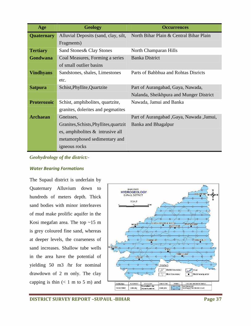
Geohydrology of the district:-
Water Bearing Formations
The Supaul district is underlain by
Quaternary Alluvium down to
hundreds of meters depth. Thick
sand bodies with minor interleaves
of mud make prolific aquifer in the
Kosi megafan area. The top ~15 m
is grey coloured fine sand, whereas
at deeper levels, the coarseness of
sand increases. Shallow tube wells
in the area have the potential of
yielding 50 m3 /hr for nominal
drawdown of 2 m only. The clay
capping is thin (< 1 m to 5 m) and

DISTRICT SURVEY REPORT –SUPAUL -BIHAR Page 38
even absent at many places. In general, the Kosi megafan shows two major formations (Singh et
al., 1993); the upper formation is of 8-10 m thickness (less commonly from 16 to 40 m) and is
composed typically of fine sand and mud, whereas the lower formation is thicker (> 60 m) and
composed up of in general medium to coarse sand to gravel. The lower formation is thought to
have been deposited by a highly braided Kosi River during the Late Quaternary. The upper
formation represents the sequence of strata deposited by the Kosi during the latest sweep across
the megafan from east to west. The upper formation forms the younger Alluvium, while the
lower one is thought to belong to an older sequence.
The lithological logs indicate that the ground water occurs under unconfined condition. In Supaul
district. Shallow tube wells are suitable up to a depth of 50 m with discharge of 20 to 40 m3 /hr.
The deep tube well of more than 100 m depth can also be constructed with estimated discharge
of 100- 200 m3 /hr. Whereas Bamboo Boring of 20 to 25 m depth tapping water table aquifer can
yield 10 to 20 m 3 /hr with a safe draw down.
Depth to Water Level:-
Depth to water level in the Supaul district remains shallow during pre- as well as post-monsoon
periods, going maximum up to 5.0 m bgl at few patches . Water level for the year 2011 indicates
a maximum of 3.85 m bgl during the pre-monsoon measurement. Few patches even possess
depth to water levels within 2.0 m bgl, creating water-logging conditions. The water level in the
district possesses a relation with the bed level elevation and flow in the Kosi River at the western
parts of the district.
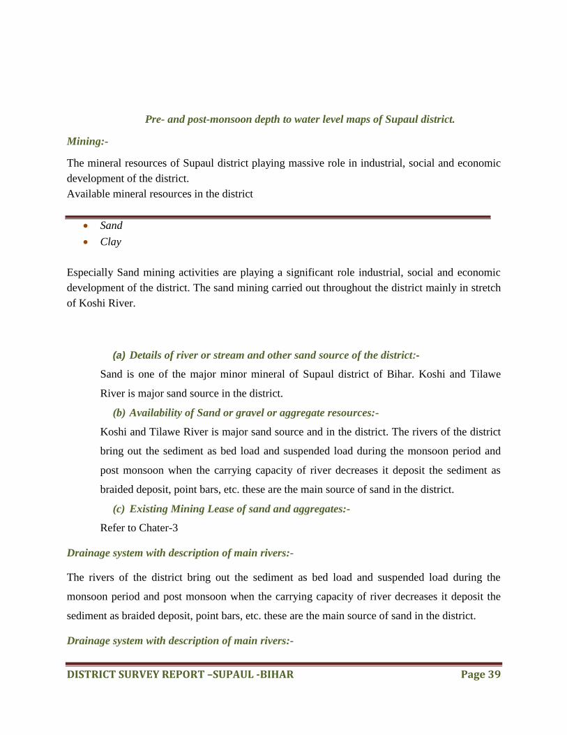
DISTRICT SURVEY REPORT –SUPAUL -BIHAR Page 39
Pre- and post-monsoon depth to water level maps of Supaul district.
Mining:-
The mineral resources of Supaul district playing massive role in industrial, social and economic
development of the district.
Available mineral resources in the district
Sand
Clay
Especially Sand mining activities are playing a significant role industrial, social and economic
development of the district. The sand mining carried out throughout the district mainly in stretch
of Koshi River.
(a) Details of river or stream and other sand source of the district:-
Sand is one of the major minor mineral of Supaul district of Bihar. Koshi and Tilawe
River is major sand source in the district.
(b) Availability of Sand or gravel or aggregate resources:-
Koshi and Tilawe River is major sand source and in the district. The rivers of the district
bring out the sediment as bed load and suspended load during the monsoon period and
post monsoon when the carrying capacity of river decreases it deposit the sediment as
braided deposit, point bars, etc. these are the main source of sand in the district.
(c) Existing Mining Lease of sand and aggregates:-
Refer to Chater-3
Drainage system with description of main rivers:-
The rivers of the district bring out the sediment as bed load and suspended load during the
monsoon period and post monsoon when the carrying capacity of river decreases it deposit the
sediment as braided deposit, point bars, etc. these are the main source of sand in the district.
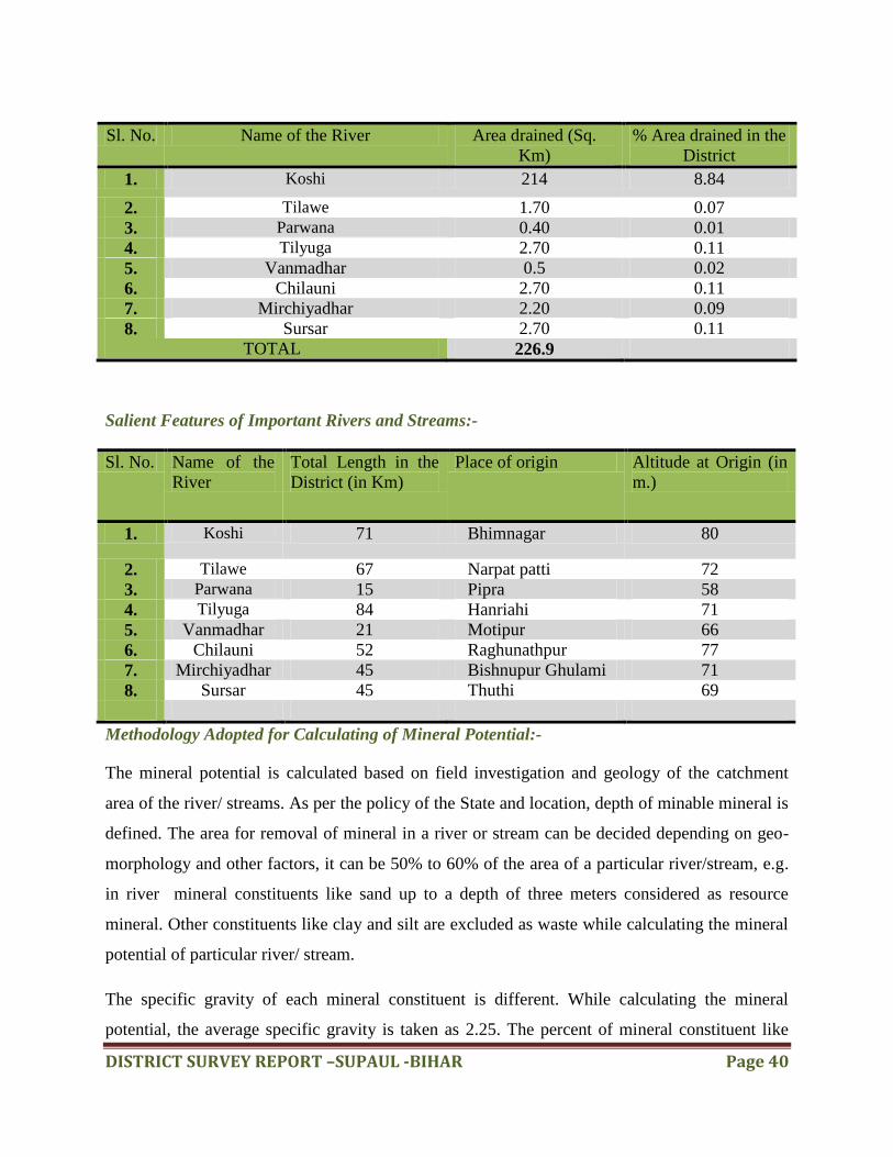
Drainage system with description of main rivers:-
DISTRICT SURVEY REPORT –SUPAUL -BIHAR Page 40
Sl. No. Name of the River Area drained (Sq.
Km)
% Area drained in the
District
1. Koshi 214 8.84
2. Tilawe 1.70 0.07
3. Parwana 0.40 0.01
4. Tilyuga 2.70 0.11
5. Vanmadhar 0.5 0.02
6. Chilauni 2.70 0.11
7. Mirchiyadhar 2.20 0.09
8. Sursar 2.70 0.11
TOTAL 226.9
Salient Features of Important Rivers and Streams:-
Sl. No. Name of the
River
Total Length in the
District (in Km)
Place of origin Altitude at Origin (in
m.)
1. Koshi 71 Bhimnagar 80
2. Tilawe 67 Narpat patti 72
3. Parwana 15 Pipra 58
4. Tilyuga 84 Hanriahi 71
5. Vanmadhar 21 Motipur 66
6. Chilauni 52 Raghunathpur 77
7. Mirchiyadhar 45 Bishnupur Ghulami 71
8. Sursar 45 Thuthi 69
Methodology Adopted for Calculating of Mineral Potential:-
The mineral potential is calculated based on field investigation and geology of the catchment
area of the river/ streams. As per the policy of the State and location, depth of minable mineral is
defined. The area for removal of mineral in a river or stream can be decided depending on geo-
morphology and other factors, it can be 50% to 60% of the area of a particular river/stream, e.g.
in river mineral constituents like sand up to a depth of three meters considered as resource
mineral. Other constituents like clay and silt are excluded as waste while calculating the mineral
potential of particular river/ stream.
The specific gravity of each mineral constituent is different. While calculating the mineral
potential, the average specific gravity is taken as 2.25. The percent of mineral constituent like

DISTRICT SURVEY REPORT –SUPAUL -BIHAR Page 41
sand also varies for different river and streams. While calculating the mineral potential the
percentage of each mineral constituent is taken as Sand 25-30% and 5-10% for silt and clay.
The quantum of deposition varies from stream to stream depending upon factors like catchment
lithology, discharge, river profile and geomorphology of the river course. There are certain geo-
morphological features developed in the river beds such as channel bar, point bar etc. where
annual deposition is more even two to three meters.
The details are given below:
River of Stream Portion of
the river or
stream
recommend
ed for
mineral
concession
( in Sq.
Km)
Length of area
recommended
for mineral
concession (in
Kilometer)
Average
width of area
recommende
d for mineral
concession in
meter)
Area recommended
for mineral
concession (In lakh
Square Meter)
Mineable
Mineral
Potential (In
Lakh Metric
Tonne) 60% of
total Mineral
Koshi 214 71 3014.084 2139.99 5893.55
Tilawe 1.70 67 25.37 16.99 46.81
Parwana 0.40 15 26.66 3.99 11.01
Tilyuga 2.70 84 32.14 26.99 74.35
Vanmadhar 0.5 21 23.80 4.99 13.76
Chilauni 2.70 52 51.92 26.99 74.35
Mirchiyadhar 2.20 45 48.88 21.99 60.58
Sursar 2.70 45 60 27 74.35
Total 226.9 3282.854 6248.76
Mineral Potential is calculated in Following Way:-
Mineral Potential:-
Sand (MT) Total Mineable Mineral Potential(MT)
6248.76 Lakh MT 6248.76 Lakh MT
Annual Deposition (30%)
1874.62 Lakh MT 1874.62 Lakh MT
Conclusion:-
The process of Sand / Soil reclamations is highly dependent upon the rainfall received in the
catchment areas of rivers and their tributaries and the velocity of river. It is a dynamic process.
DISTRICT SURVEY REPORT –SUPAUL -BIHAR Page 42
Thus it is difficult to predict, what quantity of Sand / Soil may be reclaimed/redeposit by river.
Because, in case of less rain, less water in the river, there may be less erosion and transportation
may also be minimal and as a result deposition too will be less. Moreover, in case of floods, the
sudden gush of water may force the change in the river course, thus old sites of sand deposition
may not be relevant.
The data narrated in the report, regarding annual deposition of sand and associated aggregates
and mineable mineral potential is concerned, is only estimation based on the data provided by the
district mining office. Thus, the figures may vary from area to area and year on year basis.
Therefore, this document is not static one but has to be a dynamic one, the figures of which may
vary with respect to time.
These mineral concessions shall also reduce demand load and will be helpful to minimize illegal
extraction of minerals, failure of which may result in to illegal mining at odd hours and shall be
haphazard and more detrimental to the local ecology. Irrespective of it following geo-scientific
considerations are also suggested to be taken into account during the river bed mining in a
particular area:
Abandoned stream channels or terrace and inactive floodplains may be preferred rather
than active channels and their deltas and floodplains.
Stream should not be diverted to form inactive channel.
Mining below subterranean water level should be avoided as a safeguard against
environmental contamination and over exploitation of resources.
Large rivers and streams whose periodic sediment replenishment capacities are larger,
may be preferred than smaller rivers.
Segments of braided river system should be used preferably falling within the lateral
migration area of the river regime that enhances the feasibility of sediment
replenishment.
Mining at the concave side of the river channel should be avoided to prevent bank
erosion. Similarly meandering segment of a river should be selected for mining in such a
way as to avoid natural eroding banks and to promote mining on naturally building
(aggrading) meander components.
Continued riverbed material mining in a given segment of the river will induce seasonal
scouring and intensify the erosion activity within the channel. This will have an adverse
DISTRICT SURVEY REPORT –SUPAUL -BIHAR Page 43
effect not only within the mining area but also both in upstream and downstream of the
river course. Hazardous effects of such scouring and enhanced erosion due to riverbed
mining should be evaluated periodically and avoided for sustainable mining activities.
Mining area should be demarcated on the ground with Pucca pillars so as to avoid illegal
unscientific mining.
It is recommended that Sub Divisional Level Committee may take into consideration all
its relevant aspects / data while scrutinizing and recommending the application for EC to
the concerned Authority

DISTRICT SURVEY REPORT –SUPAUL -BIHAR Page 44
CHAPTER – 12
BRICK KILNS IN SUPAUL DISTRICT
The state of Bihar is developing rapidly. In
the five year period from 2004 to 2009
Bihar‟s Gross Domestic Product (GDP)
has grown by 11.03% and between 2001
and 2011 there has been a significant
increase in urbanization with the number
of towns increasing from 120 to 213
according to the latest census. This has
been possible through investment in various sectors, especially the construction sector. If this
growth rate needs to be sustained, the demand for quality building materials will increase
manifold. In rural areas too, Bihar faces challenges with the need for over 7.5 billion bricks over
the next five years to meet the rural housing gap. A field study was conducted in 5 districts on
Bihar to understand the present scenario of the brick industry and to assess the market potential
and barriers for introducing energy efficient technologies for walling materials. The major brick
producing districts of Bihar is Patna, Nalanda, Siwan, Muzaffarpur, Sitamarhi, East and West
Champaran, Darbhanga, Samastipur and Madhubani. With over 5,700 authorized brick kilns the
state produces around 17 billion bricks per year. The brick sector in Bihar is growing at a rate of
9%, however it continues to be dominated by traditional technology - the Fixed Chimney Bulls
Trench Kiln (FCBTK). Unlike the rest of India (except Punjab, Haryana, Uttar Pradesh and West
Bengal) the state of Bihar is the only state which has transformed the brick firing technology
from movable to fixed chimney.
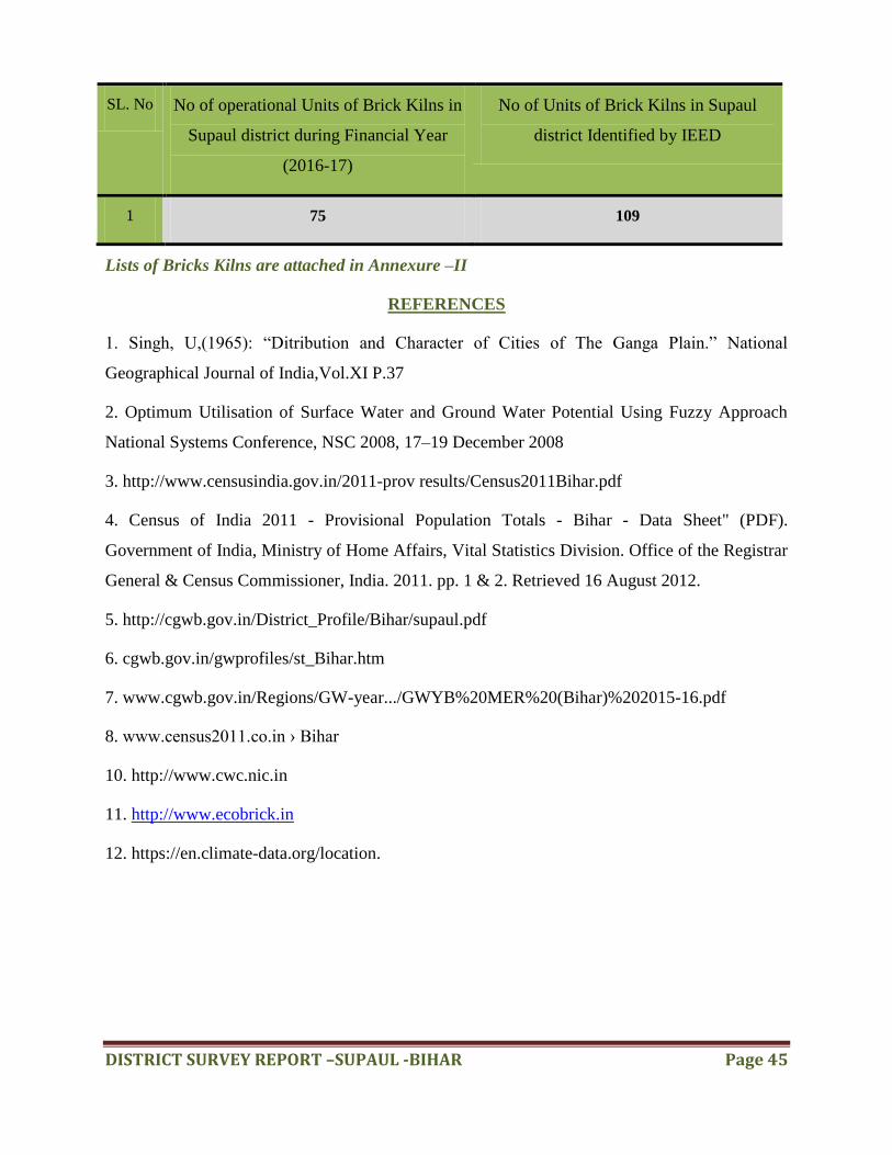
Status of Brick Kilns in Supaul District
DISTRICT SURVEY REPORT –SUPAUL -BIHAR Page 45
SL. No No of operational Units of Brick Kilns in
Supaul district during Financial Year
(2016-17)
No of Units of Brick Kilns in Supaul
district Identified by IEED
1 75 109
Lists of Bricks Kilns are attached in Annexure –II
REFERENCES
1. Singh, U,(1965): “Ditribution and Character of Cities of The Ganga Plain.” National
Geographical Journal of India,Vol.XI P.37
2. Optimum Utilisation of Surface Water and Ground Water Potential Using Fuzzy Approach
National Systems Conference, NSC 2008, 17–19 December 2008
3. http://www.censusindia.gov.in/2011-prov results/Census2011Bihar.pdf
4. Census of India 2011 - Provisional Population Totals - Bihar - Data Sheet" (PDF).
Government of India, Ministry of Home Affairs, Vital Statistics Division. Office of the Registrar
General & Census Commissioner, India. 2011. pp. 1 & 2. Retrieved 16 August 2012.
5. http://cgwb.gov.in/District_Profile/Bihar/supaul.pdf
6. cgwb.gov.in/gwprofiles/st_Bihar.htm
7. www.cgwb.gov.in/Regions/GW-year.../GWYB%20MER%20(Bihar)%202015-16.pdf
8. www.census2011.co.in › Bihar
10. http://www.cwc.nic.in
11. http://www.ecobrick.in
12. https://en.climate-data.org/location.

DISTRICT SURVEY REPORT –SUPAUL -BIHAR Page 46
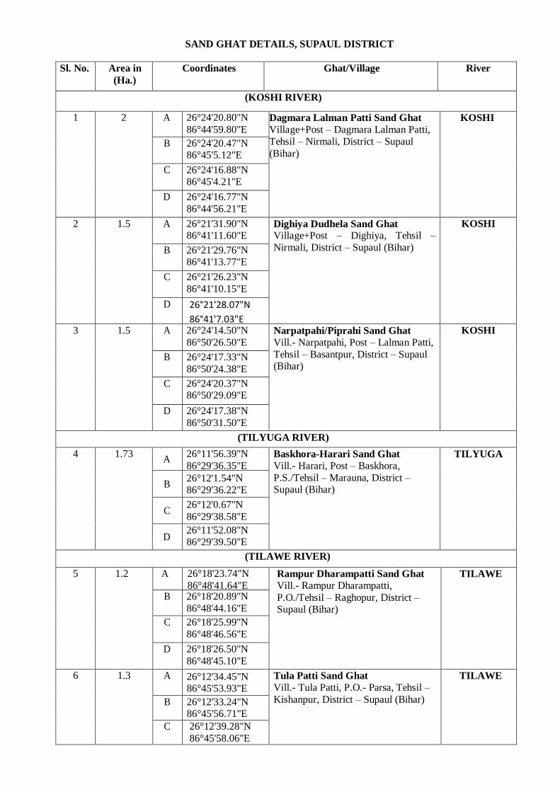
SAND GHAT DETAILS, SUPAUL DISTRICT
Sl. No. Area in
(Ha.)
Coordinates Ghat/Village River
(KOSHI RIVER)
1 2 A 26°24'20.80"N
86°44'59.80"E Dagmara Lalman Patti Sand Ghat
Village+Post – Dagmara Lalman Patti,
Tehsil – Nirmali, District – Supaul
(Bihar)
KOSHI
B 26°24'20.47"N 86°45'5.12"E
C 26°24'16.88"N 86°45'4.21"E
D 26°24'16.77"N
86°44'56.21"E
2 1.5 A 26°21'31.90"N 86°41'11.60"E
Dighiya Dudhela Sand Ghat Village+Post – Dighiya, Tehsil –
Nirmali, District – Supaul (Bihar)
KOSHI
B 26°21'29.76"N 86°41'13.77"E
C 26°21'26.23"N
86°41'10.15"E
D 26°21'28.07"N
86°41'7.03"E 3 1.5 A 26°24'14.50"N
86°50'26.50"E Narpatpahi/Piprahi Sand Ghat
Vill.- Narpatpahi, Post – Lalman Patti,
Tehsil – Basantpur, District – Supaul (Bihar)
KOSHI
B 26°24'17.33"N
86°50'24.38"E
C 26°24'20.37"N 86°50'29.09"E
D 26°24'17.38"N
86°50'31.50"E
(TILYUGA RIVER)
4 1.73 A
26°11'56.39"N
86°29'36.35"E Baskhora-Harari Sand Ghat
Vill.- Harari, Post – Baskhora,
P.S./Tehsil – Marauna, District – Supaul (Bihar)
TILYUGA
B 26°12'1.54"N 86°29'36.22"E
C 26°12'0.67"N
86°29'38.58"E
D 26°11'52.08"N 86°29'39.50"E
(TILAWE RIVER)
5 1.2 A 26°18'23.74"N
86°48'41.64"E Rampur Dharampatti Sand Ghat
Vill.- Rampur Dharampatti,
P.O./Tehsil – Raghopur, District – Supaul (Bihar)
TILAWE
B 26°18'20.89"N
86°48'44.16"E
C 26°18'25.99"N
86°48'46.56"E
D 26°18'26.50"N
86°48'45.10"E
6 1.3 A 26°12'34.45"N 86°45'53.93"E
Tula Patti Sand Ghat
Vill.- Tula Patti, P.O.- Parsa, Tehsil –
Kishanpur, District – Supaul (Bihar)
TILAWE
B 26°12'33.24"N 86°45'56.71"E
C 26°12'39.28"N
86°45'58.06"E
D 26°12'39.98"N 86°45'56.05"E
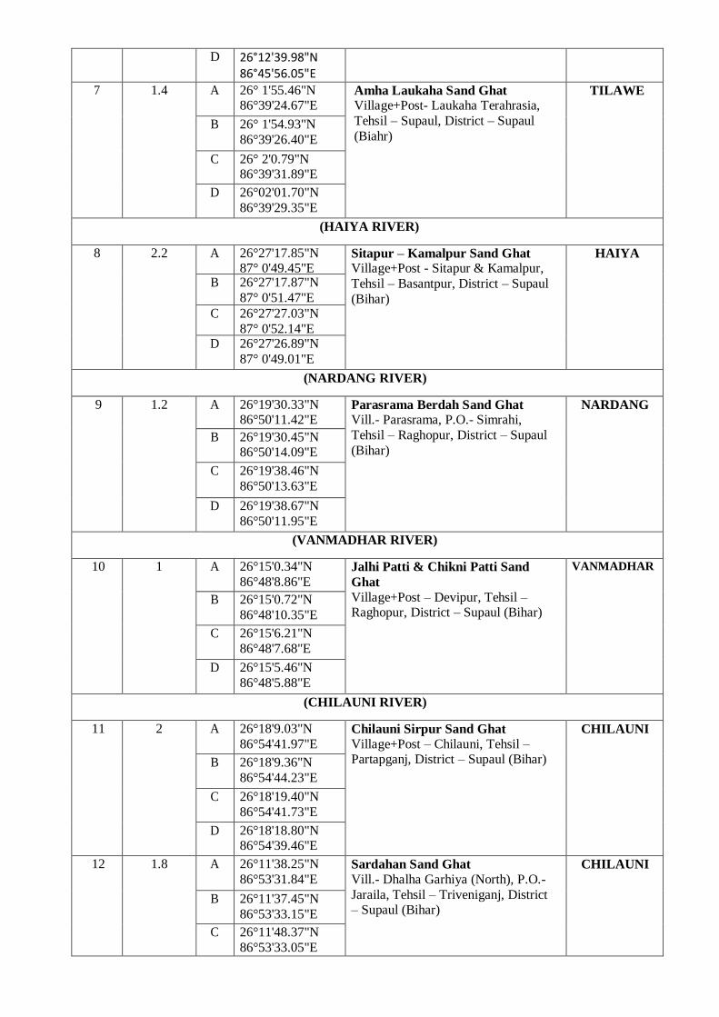
7 1.4 A 26° 1'55.46"N 86°39'24.67"E
Amha Laukaha Sand Ghat Village+Post- Laukaha Terahrasia,
Tehsil – Supaul, District – Supaul
(Biahr)
TILAWE
B 26° 1'54.93"N
86°39'26.40"E
C 26° 2'0.79"N 86°39'31.89"E
D 26°02'01.70"N
86°39'29.35"E
(HAIYA RIVER)
8 2.2 A 26°27'17.85"N 87° 0'49.45"E
Sitapur – Kamalpur Sand Ghat Village+Post - Sitapur & Kamalpur,
Tehsil – Basantpur, District – Supaul
(Bihar)
HAIYA
B 26°27'17.87"N
87° 0'51.47"E
C 26°27'27.03"N
87° 0'52.14"E D 26°27'26.89"N
87° 0'49.01"E
(NARDANG RIVER)
9 1.2 A 26°19'30.33"N 86°50'11.42"E
Parasrama Berdah Sand Ghat Vill.- Parasrama, P.O.- Simrahi,
Tehsil – Raghopur, District – Supaul
(Bihar)
NARDANG
B 26°19'30.45"N 86°50'14.09"E
C 26°19'38.46"N
86°50'13.63"E
D 26°19'38.67"N
86°50'11.95"E
(VANMADHAR RIVER)
10 1 A 26°15'0.34"N
86°48'8.86"E Jalhi Patti & Chikni Patti Sand
Ghat
Village+Post – Devipur, Tehsil – Raghopur, District – Supaul (Bihar)
VANMADHAR
B 26°15'0.72"N
86°48'10.35"E
C 26°15'6.21"N
86°48'7.68"E
D 26°15'5.46"N
86°48'5.88"E
(CHILAUNI RIVER)
11 2 A 26°18'9.03"N
86°54'41.97"E Chilauni Sirpur Sand Ghat
Village+Post – Chilauni, Tehsil – Partapganj, District – Supaul (Bihar)
CHILAUNI
B 26°18'9.36"N
86°54'44.23"E
C 26°18'19.40"N
86°54'41.73"E
D 26°18'18.80"N 86°54'39.46"E
12 1.8 A 26°11'38.25"N
86°53'31.84"E Sardahan Sand Ghat
Vill.- Dhalha Garhiya (North), P.O.-
Jaraila, Tehsil – Triveniganj, District – Supaul (Bihar)
CHILAUNI
B 26°11'37.45"N
86°53'33.15"E
C 26°11'48.37"N
86°53'33.05"E
D 26°11'48.00"N 86°53'31.10"E
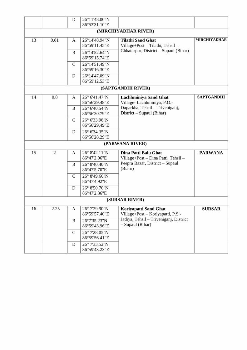
(MIRCHIYADHAR RIVER)
13 0.81 A 26°14'48.94"N
86°59'11.45"E Tilathi Sand Ghat
Village+Post – Tilathi, Tehsil – Chhatarpur, District – Supaul (Bihar)
MIRCHIYADHAR
B 26°14'52.64"N
86°59'15.74"E
C 26°14'51.49"N
86°59'16.30"E
D 26°14'47.09"N
86°59'12.53"E
(SAPTGANDHI RIVER)
14 0.8 A 26° 6'41.47"N
86°56'29.48"E
Lachhminiya Sand Ghat
Village- Lachhminiya, P.O.- Daparkha, Tehsil – Triveniganj,
District – Supaul (Bihar)
SAPTGANDHI
B 26° 6'40.54"N
86°56'30.79"E
C 26° 6'33.98"N 86°56'29.49"E
D 26° 6'34.35"N
86°56'28.29"E
(PARWANA RIVER)
15 2 A 26° 8'42.11"N
86°47'2.96"E Dina Patti Balu Ghat
Village+Post – Dina Patti, Tehsil – Peepra Bazar, District – Supaul
(Biahr)
PARWANA
B 26° 8'40.40"N
86°47'5.70"E
C 26° 8'49.66"N
86°47'4.92"E
D 26° 8'50.70"N 86°47'2.36"E
(SURSAR RIVER)
16 2.25 A 26° 7'29.90"N 86°59'57.40"E
Koriyapatti Sand Ghat Village+Post – Koriyapatti, P.S.-
Jadiya, Tehsil – Triveniganj, District
– Supaul (Bihar)
SURSAR
B 26°7'35.23"N 86°59'43.96"E
C 26° 7'28.05"N
86°59'56.41"E
D 26° 7'33.52"N
86°59'43.23"E

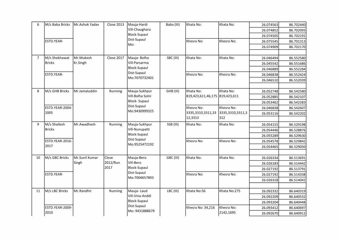
S. No. Name of M/s Name of
Proprietor
Running or
close
Address/ Mauja/
Contact
Mark/ Grade Khata& Khesra
No.of soil cutting
Area
Khata &Khesra
No. of bricks kline
area
Latitude (N) Longitude (E)
26.070678 86.705609
26.705402 86.705402
26.071279 86.706212
26.070936 86.705664
26.070788 86.705827
26.055493 86.700022
26.055479 86.599919
26.056062 86.700164
26.055900 86.700464
26.055749 86.700165
26.053309 86.696350
26.053421 86.695763
26.053657 86.695862
26.053452 86.696333
26.053593 86.696085
26.043014 86.674335
26.042401 86.673999
26.042395 86.673354
26.043006 86.674450
26.042888 86.674151
26.031528 86.657686
26.031001 86.658500
26.031078 86.658961
26.030967 86.659001
26.031117 86.658566
BLOCK - SUPAUL
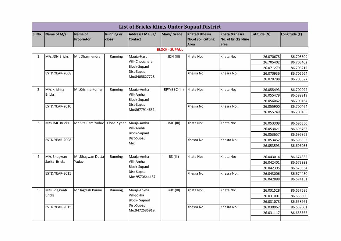
Mr.Bhagwan Dutta
Yadav
Running Mauja-Amha
Vill- Amha
Block-Supaul
Dist-Supaul
Mo: 9570644487
Close 2 year Mauja-Amha
Vill- Amha
Block-Supaul
Dist-Supaul
Mo:
RPY/BBC (III) Khata No: Khata No:
ESTD.YEAR-2010 Khesra No: Khesra No:
2 M/s Krishna
Bricks
Mr.Krishna Kumar Running Mauja-Amha
Vill- Amha
Block-Supaul
Dist-Supaul
Mo:8677914631
BBC (III) Khata No: Khata No:
ESTD.YEAR-2015 Khesra No: Khesra No:
5 M/s Bhagwati
Bricks
Mr.Jagdish Kumar Running Mauja-Lokha
Vill-Lokha
Block- Supaul
Dist-Supaul
Mo:9472535919
BS (III) Khata No: Khata No:
ESTD.YEAR-2015 Khesra No: Khesra No:
4 M/s Bhagwan
Sarita Bricks
List of Bricks Klin,s Under Supaul District
1 M/s JDN Bricks
ESTD.YEAR-2008
Mr. Dharmendra Running Mauja-Hardi
Vill- Choughara
Block-Supaul
Dist-Supaul
Mo:8405827728
JDN (III) Khata No:
Khesra No:
Khata No:
Khesra No:
JMC (III) Khata No: Khata No:
ESTD.YEAR-2008 Khesra No: Khesra No:
3 M/s JMC Bricks Mr.Sita Ram Yadav
26.074563 86.702440
26.074852 86.702093
26.074505 86.702191
26.075545 86.701313
26.074909 86.702170
26.046494 86.552580
26.045542 86.551686
26.046889 86.552284
26.046838 86.552424
26.046510 86.552039
26.052748 86.542580
26.052885 86.542107
26.053462 86.542283
26.046838 86.542607
26.053116 86.542202
26.054155 86.529198
26.054446 86.528876
26.055289 86.529630
26.054578 86.529842
26.054465 86.529050
26.026334 86.513691
26.026183 86.514442
26.027192 86.513791
26.027192 86.514338
26.026318 86.514042
26.092332 86.640319
26.092209 86.640532
26.093204 86.640448
26.093412 86.640697
26.092670 86.640912
LBC (III) Khata No:56 Khata No:275
ESTD.YEAR-2009-
2010
Khesra No: 34,216 Khesra No:
2142,1695
11 M/s LBC Bricks Mr.Randhir Running Mauja- Laud
Vill-Vina-Anddi
Block-Supaul
Dist-Supaul
Mo: 9431888679
GBC (III) Khata No: Khata No:
ESTD.YEAR- Khesra No: Khesra No:
10 M/s GBC Bricks Mr.Sunil Kumar
Singh
Close
2012/Run
2017
Mauja-Bero
Vill-Bero
Block-Supaul
Dist-Supaul
Mo:7004657893
SSB (III) Khata No: Khata No:
ESTD.YEAR-2016-
2017
Khesra No: Khesra No:
9 M/s Shailesh
Bricks
Mr.Awadhesh Running Mauja-Sukhpur
Vill-Nunupatti
Block-Supaul
Dist-Supaul
Mo:9525472192
GHB (III) Khata No:
819,423,611,46,175
Khata No:
819,423,611
ESTD.YEAR-2004-
2005
Khesra No:
3335,3310,3311,33
12,3313
Khesra No:
3335,3310,3311,3
312
8 M/s GHB Bricks Mr.Jamaluddin Running Mauja-Sukhpur
Vill-Bolha Solni
Block- Supaul
Dist-Supaul
Mo:9430999325
SBC (III) Khata No: Khata No:
ESTD.YEAR- Khesra No: Khesra No:
7 M/s Shekhawat
Bricks
Mr.Mukesh
Kr.Singh
Close 2017 Mauja- Bolha
Vill-Parsarma
Block-Supaul
Dist-Supaul
Mo:7070732401
Baba (III) Khata No: Khata No:
ESTD.YEAR- Khesra No: Khesra No:
6 M/s Baba Bricks Mr.Ashok Yadav Close 2013 Mauja-Hardi
Vill-Chaughara
Block-Supaul
Dist-Supaul
Mo:
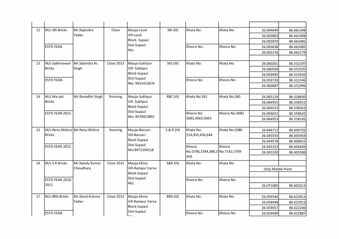
26.094049 86.661348
26.092802 86.661908
26.092870 86.662485
26.093638 86.662085
26.092376 86.662178
26.060261 86.552197
26.060569 86.552335
26.059995 86.552050
26.059724 86.551546
26.060687 86.551996
26.065129 86.558830
26.064955 86.558551
26.064523 86.558263
26.064651 86.558632
26.064953 86.558145
26.044712 86.604702
26.045555 86.605454
26.044978 86.606015
26.045253 86.605830
26.045320 86.605589
26.071085 86.603213
26.059346 86.622613
26.058448 86.622913
26.059057 86.622246
26.059589 86.622887
Only Middle Point
BNS (III) Khata No: Khata No:
ESTD.YEAR- Khesra No: Khesra No:
17 M/s BNS Bricks Mr.Nand Kishore
Yadav
Close 2013 Mauja-Ekma
Vill-Rampur Varna
Block-Supaul
Dist-Supaul
Mo:
S&R (III) Khata No: Khata No:
ESTD.YEAR-2010-
2011
Khesra No: Khesra No:
16 M/s S.R Bricks Mr.Nandu Kumar
Choudhary
Close 2015 Mauja-Ekma
Vill-Rampur Varna
Block-Supaul
Dist-Supaul
Mo:
S & R (III) Khata No:
514,455,456,644
Khata No:1080
ESTD.YEAR-2012 Khesra
No:3790,3784,388,3
459
Khesra
No:7142,5709
15 M/s Renu Mishra
Bricks
Mr.Renu Mishra Running Mauja-Baruari
Vill-Baruari
Block-Supaul
Dist-Supaul
Mo:9471254118
RBC (III) Khata No:261 Khata No:260
ESTD.YEAR-2015 Khesra No:
3682,3663,5663
Khesra No:3682
14 M/s Ma sati
Bricks
Mr.Ranadhir Singh Running Mauja-Sukhpur
Vill- Sukhpur
Block-Supaul
Dist-Supaul
Mo: 9570413891
SKS (III) Khata No: Khata No:
ESTD.YEAR- Khesra No: Khesra No:
13 M/s Sakhreswari
Bricks
Mr.Satendra Kr.
Singh
Close 2013 Mauja-Sukhpur
Vill- Sukhpur
Block-Supaul
Dist-Supaul
Mo: 9431413676
SRI (III) Khata No: Khata No:
ESTD.YEAR- Khesra No: Khesra No:
12 M/s SRI Bricks Mr.Rajendra
Yadav
Close Mauja-Loud
Vill-Loud
Block- Supaul
Dist-Supaul
Mo:
LBC (III)
ESTD.YEAR-2009-
2010
Khesra No: 34,216 Khesra No:
2142,1695
11 Mr.Randhir Running Mauja- Laud
Vill-Vina-Anddi
Block-Supaul
Dist-Supaul
Mo: 9431888679

26.059346 86.622613
26.047567 86.600485
26.047590 86.599802
26.047662 86.599860
26.047421 86.601527
26.047536 86.600031
26.141867 86.679643
26.142298 86.678996
26.141760 86.678709
26.140576 86.679600
26.141418 86.679779
26.245546 86.811090
26.245667 86.810788
26.246257 86.809932
26.246389 86.810083
26.246262 86.810408
26.247462 86.814266
26.247741 86.813614
26.245750 86.812797
26.246389 86.812502
26.246262 86.814343
26.248023 86.817974
26.247695 86.817756
26.247494 86.817931
26.247428 86.817531
26.247828 86.817902
26.249121 86.818805
26.249577 86.819213
BLOCK - RAGHOPUR
23 M/s Mangalam Mr.Sachin Kumar (
Kisan Chouk)
Running Mauja-Dharampur
Vill- Dharampur
Block-Raghopur
Dist- Supaul
Mo: 7782063300
Sachin (III) Khata No:27 Khata No:100
22 M/s Samrat
Bricks
Mr.Satya Narayan Running or
Close 2017-
2018
Mauja-Dharhara
Vill-Dharhara
Block-Raghopur
Dist-Supaul
Mo: 9431244062
Samrat (III) Khata No:79 Khata No: 54
ESTD.YEAR-2009-
2010
Khesra No: 242 Khesra No: 3245
21 M/s Bablu Bricks Mr.Chandra
Bhushan Mandal
Running Mauja-Dharhara
Vill-Dharhara
Block-Raghopur
Dist-Supaul
Mo: 7781967523
Bablu (III) Khata No:47 Khata No:14
ESTD.YEAR-2017-
2018
Khesra No:725 Khesra No:
3024,3023
20 M/s Sony Bricks Mr.Sumit
Choudhary
Running Mauja-Satkodariya
Vill-Satkodariya
Block-Raghopur
Dist-Supaul
Mo: 7808567233
Sony (III) Khata No:
18,28,20,71
Khata No:
ESTD.YEAR-2005-
2006
Khesra No:
1121,876,744,891,1
049
Khesra No:
19 M/s L.P.Y Bricks Mr.Laddu lal Close 2014 Mauja- Nirmali
Vill-Pathra
Block-Supaul
Dist-Supaul
Mo:
LPY (III) Khata No: Khata No:
ESTD.YEAR- Khesra No: Khesra No:
S.Singh (III) Khata No: Khata No:
ESTD.YEAR-2009-
2010
Khesra No: Khesra No:
18 M/s S.S Bricks Mr.Satrughan
Singh
Close 2013 Mauja-Ekma
Vill-Rampur Varna
Block-Supaul
Dist-Supaul
Mo:
BNS (III)
ESTD.YEAR- Khesra No: Khesra No:
17 Mr.Nand Kishore
Yadav
Close 2013 Mauja-Ekma
Vill-Rampur Varna
Block-Supaul
Dist-Supaul
Mo:
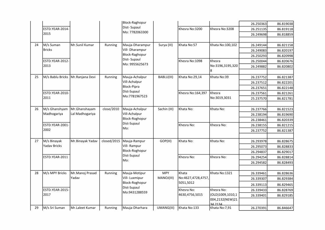
26.250363 86.819038
26.251135 86.819118
26.249698 86.818859
26.249144 86.821158
26.249083 86.820197
26.250293 86.820998
26.250044 86.820676
26.249882 86.820802
26.237752 86.821387
26.237512 86.822201
26.237651 86.822148
26.237561 86.821261
25.237570 86.821781
26.237766 86.821523
26.238194 86.819690
26.238461 86.820339
26.238155 86.821215
26.237752 86.821387
26.293978 86.828675
26.295073 86.828833
26.294837 86.829017
26.294254 86.828814
26.294582 86.828493
26.339461 86.828636
26.339307 86.829384
26.339113 86.829465
26.339433 86.828769
26.339401 86.829185
26.270391 86.84664729 M/s Sri Suman
Bricks
Mr.Laleet Kumar Running Mauja-Dharhara
Vill- Dharhara
Block-Roghopur
Dist-Supaul
Mo:9431244403
UMANG(III) Khata No:133 Khata No:7,91
28 M/s MPY Bricks Mr.Manoj Prasad
Yadav
Running Mauja-Motipur
Vill- Luxmipur
Block-Roghopur
Dist-Supaul
Mo:9431288559
MPY
MANOJ(III)
Khata
No:4627,4728,4757,
5051,5012
Khata No:1321
ESTD.YEAR-2015-
2017
Khesra No:
4630,4756,5015
Khesra No:
(OLD)1009,1010,1
004,2132(NEW)21
34,2134
27 M/s Binayak
Yadav Bricks
Mr.Binayak Yadav closed/2015 Mauja-Rampur
Vill- Rampur
Block-Roghopur
Dist-Supaul
Mo:
GOP(III) Khata No: Khata No:
ESTD.YEAR-2011 Khesra No: Khesra No:
26 M/s Ghanshyam
Madhogariya
Mr.Ghanshayam
Lal Madhogariya
close/2010 Mauja-Achalpur
Vill-Achalpur
Block-Roghopur
Dist-Supaul
Mo:
Sachin (III) Khata No: Khata No:
ESTD.YEAR-2001-
2002
Khesra No: Khesra No:
25 M/s Bablu Bricks Mr.Ranjana Devi Running Mauja-Achalpur
Vill-Achalpur
Block-Pipra
Dist-Supaul
Mo:7781967523
BABLU(III) Khata No:29,14 Khata No:39
ESTD.YEAR-2010-
2011
Khesra No:164,397 Khesra
No:3019,3031
24 M/s Suman
Bricks
Mr.Sunil Kumar Running Mauja-Dharampur
Vill- Dharampur
Block-Raghopur
Dist- Supaul
Mo: 9955625673
Surya (III) Khata No:57 Khata No:100,102
ESTD.YEAR-2012-
2013
Khesra No:1098 Khesra
No:3196,3195,320
8
23 M/s Mangalam Mr.Sachin Kumar (
Kisan Chouk)
Running Mauja-Dharampur
Vill- Dharampur
Block-Raghopur
Dist- Supaul
Mo: 7782063300
Sachin (III) Khata No:27 Khata No:100
ESTD.YEAR-2014-
2015
Khesra No:3200 Khesra No:3208

26.270360 86.846890
26.269423 86.846951
26.269549 86.846462
26.269913 86.846827
26.269509 86.849686
26.269158 86.849990
26.268484 86.849627
26.264633 86.849278
26.268476 86.849319
26.264849 86.842094
26.264464 86.841710
26.264414 86.841813
26.264622 86.841370
26.264636 86.841033
26.271767 86.852463
26.271963 86.852942
26.271326 86.852828
26.271047 86.852897
26.271217 86.852474
26.260312 86.832463
26.260988 86.839886
26.261013 86.840946
26.260483 86.840724
26.260483 86.840314
26.252858 86.832791
26.252785 86.832699
26.253773 86.832633
26.253449 86.832873
26.253139 86.832717
31 M/s YES Bricks Mr.Yashwant
Kumar
Running Mauja-Dharhara
Vill-Dharhara
Block-Raghopur
Dist- Supaul
Mo:9931685555
Jyoti (III) Khata No:22 Khata No:50
ESTD.YEAR-
Enterprise
Khesra
No:1302,1303
Khesra No:1271
30 M/s Suman
Bricks
Mr.Dilip Kumar Running Mauja-Dharhara
Vill-Dharhara
Block-Raghopur
Dist- Supaul
Mo:9431244434
Suman (III) Khata No:122 Khata No:28
ESTD.YEAR-2015-
2016
Khesra No:1140 Khesra No:1132
29 M/s Sri Suman
Bricks
Mr.Laleet Kumar Running Mauja-Dharhara
Vill- Dharhara
Block-Roghopur
Dist-Supaul
Mo:9431244403
UMANG(III) Khata No:133 Khata No:7,91
ESTD.YEAR-2008-
2009
Khesra No:2735 Khesra
No:1941,1951,189
6
32 M/s Anand
Construction
Mr.Basant Kumar Running Mauja-Gaddi
Vill-Gaddi
Block-Raghopur
Dist-Supaul
Mo: 9931685555
Jyoti (III) Khata No:1071 Khata No: 66
ESTD.YEAR-1997-
1998
Khesra No: 2875 Khesra No:
2890,2889
33 M/s Mangalam Mr.Sachin
Madhogarhiyam (
Mahadev sthan)
Running Mauja-Dharhara
Vill-Dharhara
Block-Raghopur
Dist- Supaul
Mo:9931129511
Sachin (III) Khata No: 53 Khata No:155
ESTD.YEAR-2013-
2014
Khesra No:398 Khesra No:1546
34 M/s Ridhi Ent. Mr.sanjeev Kumar
Madhogarhiya
Running Mauja-Dharhara
Vill-Dharhara
Block-Raghopur
Dist- Supaul
Mo:9931234444
Sachin (III) Khata No:172 Khata No:172
ESTD.YEAR-2010-
2011
Khesra No:3933 Khesra No:2347

26.263284 86.824799
26.262721 86.824485
26.262445 86.824938
26.263411 86.825119
26.263041 86.824765
26.252423 86.836061
26.252017 86.835642
26.252050 86.835863
26.252633 86.834941
26.252000 86.835864
26.252743 86.835901
26.257238 86.834573
26.255773 86.834440
26.257593 86.834941
26.257483 86.834691
26.261498 86.839578
26.262228 86.839518
26.262178 86.839901
26.261514 86.839817
26.261918 86.83963
26.267944 86.841789
26.265642 86.841509
26.268721 86.840597
26.268862 86.839868
26.267450 86.840425
26.268676 86.859717
26.268301 86.859376
26.268540 86.858958
26.268433 86.859590
26.268301 86.859219
35 M/s Ridhi Ent. Mr.sanjeev Kumar
Madhogarhiya
Running Mauja-Dharhar
Vill-Ganpatganj
Block-Raghopur
Dist-Supaul
Mo:9931234444
Sachin (III) Khata No:192 Khata No:52
ESTD.YEAR-2010-
2011
Khesra No:2556 Khesra No:3049
36 M/s Deonarayan
Yadav
Mr.Daonarayan
Yadav
Running Mauja-Dharhara
Vill-Dharhara
Block-Raghopur
Dist- Supaul
Mo:95466778576
Vikash (III) Khata No: Khata No:52,58
ESTD.YEAR-2012-
2013
Khesra No: Khesra No:
171,172
37 M/s SNY Bricks Mr.Sodanand
Yadav
Close 2013 Mauja-Dharhara
Vill-Dharhara
Block-Raghopur
Dist- Supaul
Mo:
SNY (III) Khata No: Khata No:
ESTD.YEAR-2010-
2011
Khesra No: Khesra No:
38 M/s Shiv Shakti
Bricks
Mr.Jay Shankar
Kumar Sah
Running Mauja-Dharhara
Vill-Dharhara
Block-Raghopur
Dist- Supaul
Mo: 9430424962
SSB (III) Khata No: Khata No:166,61
ESTD.YEAR-2010-
2011
Khesra No:
1579,1580,1578
Khesra No:
1579,1591,1593
39 M/s Gun Gun
Bricks
Mr.Sunil Kumar
Mohan
Running Mauja-Dharhara
Vill-Dharhara
Block-Raghopur
Dist- Supaul
Mo: 9771755949
GUNGUN (III) Khata No:62,05 Khata No:
ESTD.YEAR-2017-
2018
Khesra
No:133,1345,913,56
0
Khesra No:
40 M/s RCS Bricks Mr.Ram Chandra
Singh
Running Mauja-Radha nagar
Vill- Radha Nagar
Block- Raghopur
Dist- Supaul
Mo: 9473129140
RCS (III) Khata No: Khata No:
ESTD.YEAR-2006-
2007
Khesra No: Khesra No:

26.271686 86.857950
26.270656 86.857181
26.270584 86.857011
26.270779 86.857593
26.270703 86.857190
26.269327 86.856476
26.268669 86.856400
26.268671 86.856347
26.269645 86.856048
26.269061 86.856356
26.261757 86.860371
26.261229 86.860507
26.260981 86.860342
26.261812 86.860383
26.261351 86.860229
26.262534 86.858210
26.263116 86.858409
26.261395 86.858363
26.262964 86.858624
26.262839 86.858260
26.236129 86.857086
26.236170 86.856737
26.236841 86.856955
26.236791 86.857273
26.236323 86.857039
26.268604 86.866592
26.268707 86.866456
26.269303 86.866319
26.269332 86.866564
40 Mr.Ram Chandra
Singh
Running Mauja-Radha nagar
Vill- Radha Nagar
Block- Raghopur
Dist- Supaul
Mo: 9473129140
RCS (III)
ESTD.YEAR-2006-
2007
Khesra No: Khesra No:
41 M/s KPY Bricks Mr.Kailesh prasad
Yadav
Running Mauja-Radha nagar
Vill- Radha Nagar
Block- Raghopur
Dist- Supaul
Mo: 9006230822
KPY (III) Khata No: 168,46,17 Khata No:
ESTD.YEAR-1994-
1995
Khesra No:
3856,3673
Khesra No:78,79
42 M/s KPY Bricks Mr.Praksh Kumar Running Mauja-Radha nagar
Vill- Radha Nagar
Block- Raghopur
Dist- Supaul
Mo: 9006230822
KPY (III) Khata No:
78,7011,1109,42
Khata No:28
ESTD.YEAR-2007-
2008
Khesra No: 36,792 Khesra No: 769,
721
43 M/s Sagar Bricks Mr.Smt Chanda
Singh
Running Mauja-Radha nagar
Vill- Radha Nagar
Block- Raghopur
Dist- Supaul
Mo: 9572789800
Sagar (III) Khata No: Khata No:
ESTD.YEAR-2012-
2013
Khesra No: Khesra No:
44 M/s RDN Bricks Mr.Birendra
Kumar Singh
Running Mauja-Radha nagar
Vill- Radha Nagar
Block- Raghopur
Dist- Supaul
Mo: 9973770243
RDN (III) Khata No: Khata No:
ESTD.YEAR-2011-
2012
Khesra No: Khesra No:
45 M/s Tara Bricks Mr.Bhupendra Sah Running Mauja- Bengaipatti
Vill- Hulas
Block-Raghopur
Dist-Supaul
Mo: 9472159796
Tara (III) Khata No: Khata No:
ESTD.YEAR-2015-
2016
Khesra No: Khesra No:
46 M/s MMA Bricks Mr.Md.Moen Close 2012 Mauja- Radha
Nagar
Vill-Radha Nagar
Block-Raghopur
Dist-Supaul
Mo:
MAA (III) Khata No: Khata No:
ESTD.YEAR- Khesra No: Khesra No:

26.268988 86.866473
26.277111 86.862616
26.277864 86.862650
26.277768 86.862415
26.277129 86.862608
26.277559 86.862648
26.284711 86.929336
26.285410 86.929659
26.285275 86.928471
26.284822 86.928425
26.285263 86.929153
26.277104 86.926617
26.276911 86.926613
26.277144 86.927597
26.277721 86.928068
26.277252 86.927121
26.342292 86.888185
26.342059 86.818805
26.341796 86.818722
26.341920 86.818111
26.341980 86.818428
26.340678 86.816416
26.340446 86.817204
26.335395 86.816465
26.339969 86.816515
26.340293 86.816224
26.347812 86.826136
BLOCK - PRATAPGANJ
BLOCK - BHAPTIYAHI
46 Mr.Md.Moen Close 2012 Mauja- Radha
Nagar
Vill-Radha Nagar
Block-Raghopur
Dist-Supaul
Mo:
MAA (III)
ESTD.YEAR- Khesra No: Khesra No:
47 M/s NAK Bricks Mr.Md. Nair Khan Close 2016 Mauja- Radha
Nagar
Vill- Gadwi
Block-Raghopur
Dist-Supaul
Mo:
NAK (III) Khata No: Khata No:
ESTD.YEAR-2011-
2012
Khesra No: Khesra No:
48 M/s Sanjeev
Bricks
Mr.Ranjeet Prasad Running Mauja-Sukha Nagar
Vill-Sukha Nagar
Block-Pratap Ganj
Dist-Supaul
Mo: 9006523557
Sanjeev (III) Khata No: 18,08,17 Khata No:05
ESTD.YEAR-2010-
2011
Khesra
No:391,393,395
Khesra No:325
49 M/s Ashish Bricks Mr.Nunu Prasad
Singh
Running Mauja-Sukha Nagar
Vill-Sukha Nagar
Block-Pratap Ganj
Dist-Supaul
Mo:
Ashish (III) Khata No:784 Khata
No:406,738,546
ESTD.YEAR- Khesra
No:5308,5306,5305,
5303,5313,5314
Khesra
No:5823,5824,582
5,5826,5827,5830
50 M/s OPS Bricks Mr.Om Prakash
Sah
Running Mauja-Shahpur
Vill-Shahpur
Block-Bhaptiyahi
Dist-Supaul
Mo: 9931745144
OPS (III) Khata No: Khata No:
ESTD.YEAR-2014-
2015
Khesra No: Khesra No:
51 M/s OPS Bricks Mr.Om Prakash
Sah
Running Mauja-Jhilladumri
Vill- Jhilladumri
Block- Bhaptiyahi
Dist-Supaul
Mo:
OPS (III) Khata No:340 Khata No:417
ESTD.YEAR-2015-
2016
Khesra
No:3812,3813,3814
Khesra
No:2644,2642
52 M/s Pappu Bricks Mr.Pramod Kumar
Roy
Running Mauja-Shahpur
Vill- Prihivi patti
Block- Bhaptiyahi
Dist-Supaul
Mo: 9931471093
Pappu (III) Khata No: 379 Khata No:

26.347001 86.825553
26.347252 86.825998
26.347614 86.826305
26.347437 86.825845
26.366738 86.838150
26.367486 86.838393
26.367340 86.838713
26.360444 86.838355
26.367079 86.838367
26.367709 86.833207
26.367983 86.833303
26.367760 86.833943
26.367630 86.833880
26.367805 86.833609
26.366271 86.830372
26.365985 86.830270
26.365841 86.831241
26.366209 86.830953
26.366908 86.830754
26.377126 86.859155
26.376676 86.859073
26.376086 86.859533
26.376199 86.859168
26.336596 86.859184
26.268669 86.791744
26.269263 86.792344
26.270097 86.792528
26.268820 86.792681
26.269104 86.792086
52 M/s Pappu Bricks Mr.Pramod Kumar
Roy
Running Mauja-Shahpur
Vill- Prihivi patti
Block- Bhaptiyahi
Dist-Supaul
Mo: 9931471093
Pappu (III) Khata No: 379 Khata No:
ESTD.YEAR-2015-
2016
Khesra
No:3604,3607,3528,
3826,3658,3858
Khesra No:2267
53 M/s Ranjan
Bricks
Mr.Ram Kumar
Roy
Close 2013 Mauja- Chithi
Vill- Hanuman
Nagar
Block-Bhaptiyahi
Dist-Supaul
Mo: 9939700605
Ranjan (III) Khata No: Khata No:
ESTD.YEAR-2010-
2011
Khesra No: Khesra No:
54 M/s Bharat
Bricks
Mr.Baidnath
Kr.Roshan
Running Mauja- Chithi
Vill- Hanuman
Nagar
Block-Bhaptiyahi
Dist-Supaul
Mo: 9430491059
Bharat (III) Khata No:
514,455,456,644
Khata No:455
ESTD.YEAR-2013-
2014
Khesra
No:3790,3784,3883,
3459
Khesra No:3480
55 M/s Ranjan
Bricks
Mr.Ram Kumar
Roy
Running Mauja- Chithi
Vill- Hanuman
Nagar
Block-Bhaptiyahi
Dist-Supaul
Mo: 9939035115
9939700605
Ranjan (III) Khata No:365,966 Khata No:1048
ESTD.YEAR-2009-
2010
Khesra
No:885,927,928,930
,933,938
Khesra
No:3747,3749,964
,985
56 M/s Koshal Bricks Mr.Uma Shankar
Prasad Mohto
Close Mauja-Hariraha
Vill- Hariraha
Block-Bhaptiyahi
Dist-Supaul
Mo:9534096894
Koshal (III) Khata No: Khata No: 211
ESTD.YEAR-2015-
2016
Khesra No: Khesra No:478
57 M/s Subhash
Kumar Bricks
Mr.Subhash
Kumar
Running Mauja-Sukhasan
Vill-Lal Ganj
Block-Bhaptiyahi
Dist- Supaul
Mo: 7258981050
Swati (III) Khata No:146 Khata No:24
ESTD.YEAR-2016-
2017
Khesra
No:2559,2486,2497,
2566
Khesra
No:8188,5695,417
6,4177,4187
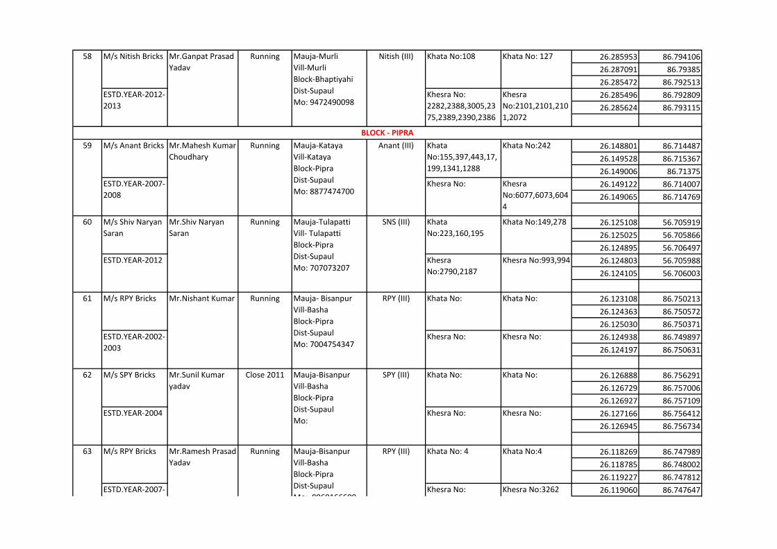
26.285953 86.794106
26.287091 86.79385
26.285472 86.792513
26.285496 86.792809
26.285624 86.793115
26.148801 86.714487
26.149528 86.715367
26.149006 86.71375
26.149122 86.714007
26.149065 86.714769
26.125108 56.705919
26.125025 56.705866
26.124895 56.706497
26.124803 56.705988
26.124105 56.706003
26.123108 86.750213
26.124363 86.750572
26.125030 86.750371
26.124938 86.749897
26.124197 86.750631
26.126888 86.756291
26.126729 86.757006
26.126927 86.757109
26.127166 86.756412
26.126945 86.756734
26.118269 86.747989
26.118785 86.748002
26.119227 86.747812
26.119060 86.747647
BLOCK - PIPRA
58 M/s Nitish Bricks Mr.Ganpat Prasad
Yadav
Running Mauja-Murli
Vill-Murli
Block-Bhaptiyahi
Dist-Supaul
Mo: 9472490098
Nitish (III) Khata No:108 Khata No: 127
ESTD.YEAR-2012-
2013
Khesra No:
2282,2388,3005,23
75,2389,2390,2386
Khesra
No:2101,2101,210
1,2072
59 M/s Anant Bricks Mr.Mahesh Kumar
Choudhary
Running Mauja-Kataya
Vill-Kataya
Block-Pipra
Dist-Supaul
Mo: 8877474700
Anant (III) Khata
No:155,397,443,17,
199,1341,1288
Khata No:242
ESTD.YEAR-2007-
2008
Khesra No: Khesra
No:6077,6073,604
4
60 M/s Shiv Naryan
Saran
Mr.Shiv Naryan
Saran
Running Mauja-Tulapatti
Vill- Tulapatti
Block-Pipra
Dist-Supaul
Mo: 707073207
SNS (III) Khata
No:223,160,195
Khata No:149,278
ESTD.YEAR-2012 Khesra
No:2790,2187
Khesra No:993,994
61 M/s RPY Bricks Mr.Nishant Kumar Running Mauja- Bisanpur
Vill-Basha
Block-Pipra
Dist-Supaul
Mo: 7004754347
RPY (III) Khata No: Khata No:
ESTD.YEAR-2002-
2003
Khesra No: Khesra No:
62 M/s SPY Bricks Mr.Sunil Kumar
yadav
Close 2011 Mauja-Bisanpur
Vill-Basha
Block-Pipra
Dist-Supaul
Mo:
SPY (III) Khata No: Khata No:
ESTD.YEAR-2004 Khesra No: Khesra No:
63 M/s RPY Bricks Mr.Ramesh Prasad
Yadav
Running Mauja-Bisanpur
Vill-Basha
Block-Pipra
Dist-Supaul
Mo: 8969166600
RPY (III) Khata No: 4 Khata No:4
ESTD.YEAR-2007-
2008
Khesra No:
3260,3261,3264,40
17
Khesra No:3262
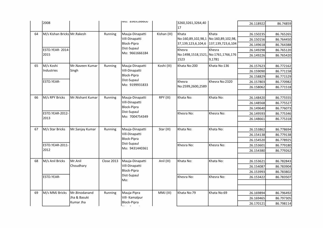
26.118922 86.74859
26.150235 86.765265
26.150156 86.764450
26.149618 86.764388
26.149298 86.765120
26.149226 86.765420
26.157623 86.772162
26.159090 86.771158
26.158829 86.771529
26.157803 86.770982
26.158062 86.771518
26.148420 86.775555
26.148568 86.775527
26.149640 86.776073
26.149593 86.775346
26.148661 86.775318
26.153862 86.778694
26.154138 86.779138
26.154520 86.778925
26.153601 86.779180
26.154380 86.779262
26.153621 86.782843
26.154087 86.783904
26.153993 86.783802
26.153422 86.783507
26.169894 86.796492
26.169465 86.797305
26.170121 86.798114
63 Mr.Ramesh Prasad
Yadav
Running Mauja-Bisanpur
Vill-Basha
Block-Pipra
Dist-Supaul
Mo: 8969166600
RPY (III)
ESTD.YEAR-2007-
2008
Khesra No:
3260,3261,3264,40
17
Khesra No:3262
64 M/s Kishan Bricks Mr.Rakesh Running Mauja-Dinapatti
Vill-Dinapatti
Block-Pipra
Dist-Supaul
Mo: 9661666184
Kishan (III) Khata
No:160,89,102,98,1
37,139,123,6,104,6
7
Khata
No:160,89,102,98,
137,139,723,6,104
,67ESTD.YEAR- 2014-
2015
Khesra
No:1498,1518,1521,
1523
Khesra
No:1761,1766,176
9,1781
65 M/s Koshi
Industries
Mr.Naveen Kumar
Singh
Running Mauja-Dinapatti
Vill-Dinapatti
Block-Pipra
Dist-Supaul
Mo: 9199931833
Koshi (III) Khata No:200 Khata No:136
ESTD.YEAR- Khesra
No:2599,2600,2589
Khesra No:2320
66 M/s RPY Bricks Mr.Nishant Kumar Running Mauja-Dinapatti
Vill-Dinapatti
Block-Pipra
Dist-Supaul
Mo: 7004754349
RPY (III) Khata No: Khata No:
ESTD.YEAR-2012-
2013
Khesra No: Khesra No:
67 M/s Star Bricks Mr.Sanjay Kumar Running Mauja-Dinapatti
Vill-Dinapatti
Block-Pipra
Dist-Supaul
Mo: 9431440361
Star (III) Khata No: Khata No:
ESTD.YEAR-2011-
2012
Khesra No: Khesra No:
68 M/s Anil Bricks Mr.Anil
Choudhary
Close 2013 Mauja-Dinapatti
Vill-Dinapatti
Block-Pipra
Dist-Supaul
Mo:
Anil (III) Khata No: Khata No:
ESTD.YEAR- Khesra No: Khesra No:
69 M/s MMJ Bricks Mr.Binodanand
Jha & Basuki
Kumar Jha
Running Mauja-Pipra
Vill- Kamalpur
Block-Pipra
Dist- Supaul
Mo: 9973136568
MMJ (III) Khata No:79 Khata No:69
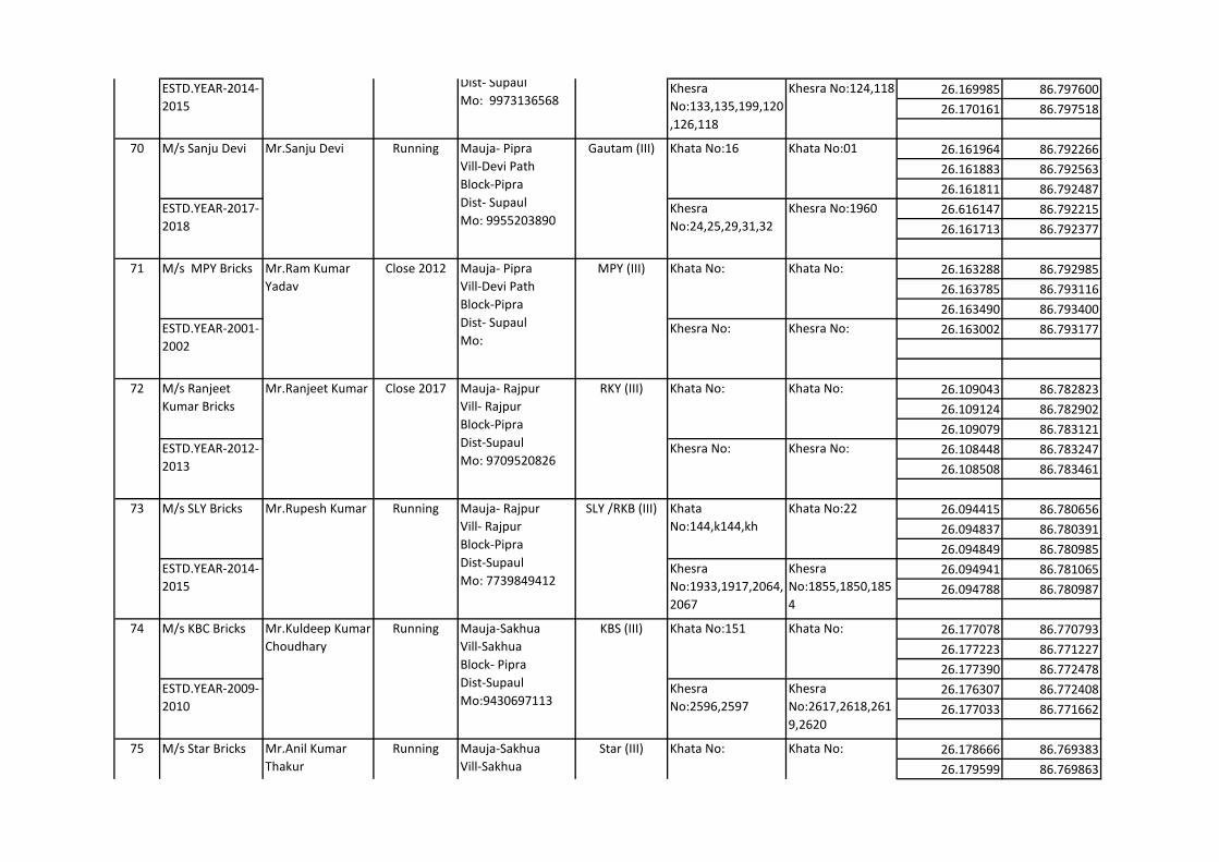
26.169985 86.797600
26.170161 86.797518
26.161964 86.792266
26.161883 86.792563
26.161811 86.792487
26.616147 86.792215
26.161713 86.792377
26.163288 86.792985
26.163785 86.793116
26.163490 86.793400
26.163002 86.793177
26.109043 86.782823
26.109124 86.782902
26.109079 86.783121
26.108448 86.783247
26.108508 86.783461
26.094415 86.780656
26.094837 86.780391
26.094849 86.780985
26.094941 86.781065
26.094788 86.780987
26.177078 86.770793
26.177223 86.771227
26.177390 86.772478
26.176307 86.772408
26.177033 86.771662
26.178666 86.769383
26.179599 86.769863
75 M/s Star Bricks Mr.Anil Kumar
Thakur
Running Mauja-Sakhua
Vill-Sakhua
Block- Pipra
Dist-Supaul
Mo:9709758557
Star (III) Khata No: Khata No:
69 Mr.Binodanand
Jha & Basuki
Kumar Jha
Running Mauja-Pipra
Vill- Kamalpur
Block-Pipra
Dist- Supaul
Mo: 9973136568
MMJ (III)
ESTD.YEAR-2014-
2015
Khesra
No:133,135,199,120
,126,118
Khesra No:124,118
70 M/s Sanju Devi Mr.Sanju Devi Running Mauja- Pipra
Vill-Devi Path
Block-Pipra
Dist- Supaul
Mo: 9955203890
Gautam (III) Khata No:16 Khata No:01
ESTD.YEAR-2017-
2018
Khesra
No:24,25,29,31,32
Khesra No:1960
71 M/s MPY Bricks Mr.Ram Kumar
Yadav
Close 2012 Mauja- Pipra
Vill-Devi Path
Block-Pipra
Dist- Supaul
Mo:
MPY (III) Khata No: Khata No:
ESTD.YEAR-2001-
2002
Khesra No: Khesra No:
72 M/s Ranjeet
Kumar Bricks
Mr.Ranjeet Kumar Close 2017 Mauja- Rajpur
Vill- Rajpur
Block-Pipra
Dist-Supaul
Mo: 9709520826
RKY (III) Khata No: Khata No:
ESTD.YEAR-2012-
2013
Khesra No: Khesra No:
73 M/s SLY Bricks Mr.Rupesh Kumar Running Mauja- Rajpur
Vill- Rajpur
Block-Pipra
Dist-Supaul
Mo: 7739849412
SLY /RKB (III) Khata
No:144,k144,kh
Khata No:22
ESTD.YEAR-2014-
2015
Khesra
No:1933,1917,2064,
2067
Khesra
No:1855,1850,185
4
74 M/s KBC Bricks Mr.Kuldeep Kumar
Choudhary
Running Mauja-Sakhua
Vill-Sakhua
Block- Pipra
Dist-Supaul
Mo:9430697113
KBS (III) Khata No:151 Khata No:
ESTD.YEAR-2009-
2010
Khesra
No:2596,2597
Khesra
No:2617,2618,261
9,2620
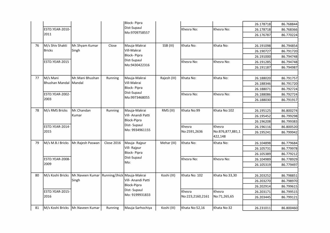
26.178718 86.768844
26.178718 86.768366
26.176787 86.770224
26.191098 86.794854
26.190727 86.791720
26.191000 86.794748
26.191285 86.794748
26.191187 86.794987
26.188020 86.791757
26.188346 86.791720
26.188071 86.792724
26.188086 86.792724
26.188030 86.791917
26.195125 86.800274
26.195452 86.799298
26.196208 86.799383
26.196116 86.800520
26.195241 86.799942
26.104898 86.779684
26.105731 86.779978
26.105389 86.779212
26.104989 86.778929
26.105319 86.779497
26.203252 86.798851
26.203270 86.798970
26.202914 86.799615
26.203171 86.799515
26.203445 86.799121
26.231011 86.80046081 M/s Koshi Bricks Mr.Naveen Kumar
Singh
Running Mauja-Sarhochiya
Vill-Sarhochiya
Block- Pipra
Dist-Supaul
Mo: 9199931833
Koshi (III) Khata No:52,16 Khata No:32
80 M/s Koshi Bricks Mr.Naveen Kumar
Singh
Running/Jhick Mauja-Makrai
Vill- Anandi Patti
Block-Pipra
Dist- Supaul
Mo: 9199931833
Koshi (III) Khata No: 102 Khata No:33,30
ESTD.YEAR-2015-
2016
Khesra
No:223,2160,2161
Khesra
No:71,265,65
79 M/s M.B.I Bricks Mr.Rajesh Paswan Close 2016 Mauja- Rajpur
Vill- Rajpur
Block- Pipra
Dist-Supaul
Mo:
Mehar (III) Khata No: Khata No:
ESTD.YEAR-2008-
2009
Khesra No: Khesra No:
78 M/s RMS Bricks Mr.Chandan
Kumar
Running Mauja-Makrai
Vill- Anandi Patti
Block-Pipra
Dist- Supaul
Mo: 9934961155
RMS (III) Khata No:99 Khata No:102
ESTD.YEAR-2014-
2015
Khesra
No:2591,2636
Khesra
No:876,877,881,1
422,148
77 M/s Mani
Bhushan Mandal
Mr.Mani Bhushan
Mandal
Running Mauja-Makrai
Vill-Makrai
Block- Pipra
Dist-Supaul
Mo:9973468055
Rajesh (III) Khata No: Khata No:
ESTD.YEAR-2002-
2003
Khesra No: Khesra No:
76 M/s Shiv Shakti
Bricks
Mr.Shyam Kumar
Singh
Close Mauja-Makrai
Vill-Makrai
Block- Pipra
Dist-Supaul
Mo:9430422316
SSB (III) Khata No: Khata No:
ESTD.YEAR-2015 Khesra No: Khesra No:
75 M/s Star Bricks Mr.Anil Kumar
Thakur
Running Mauja-Sakhua
Vill-Sakhua
Block- Pipra
Dist-Supaul
Mo:9709758557
Star (III) Khata No: Khata No:
ESTD.YEAR-2010-
2011
Khesra No: Khesra No:
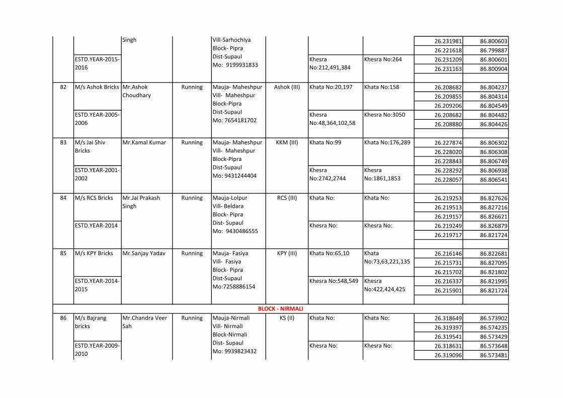
26.231981 86.800603
26.221618 86.799887
26.231209 86.800601
26.231163 86.800904
26.208682 86.804237
26.209855 86.804314
26.209206 86.804549
26.208682 86.804482
26.208880 86.804426
26.227874 86.806302
26.228020 86.806308
26.228843 86.806749
26.228292 86.806938
26.228057 86.806541
26.219253 86.827626
26.219513 86.827216
26.219157 86.826621
26.219249 86.826879
26.219717 86.821724
26.216146 86.822681
26.215731 86.827095
26.215702 86.821802
26.216337 86.821995
26.215901 86.821724
26.318649 86.573902
26.319397 86.574235
26.319541 86.573429
26.318631 86.573648
26.319096 86.573481
BLOCK - NIRMALI
86 M/s Bajrang
bricks
Mr.Chandra Veer
Sah
Running Mauja-Nirmali
Vill- Nirmali
Block-Nirmali
Dist- Supaul
Mo: 9939823432
KS (II) Khata No: Khata No:
ESTD.YEAR-2009-
2010
Khesra No: Khesra No:
85 M/s KPY Bricks Mr.Sanjay Yadav Running Mauja- Fasiya
Vill- Fasiya
Block- Pipra
Dist-Supaul
Mo:7258886154
KPY (III) Khata No:65,10 Khata
No:73,63,221,135
ESTD.YEAR-2014-
2015
Khesra No:548,549 Khesra
No:422,424,425
84 M/s RCS Bricks Mr.Jai Prakash
Singh
Running Mauja-Lolpur
Vill- Beldara
Block- Pipra
Dist- Supaul
Mo: 9430486555
RCS (III) Khata No: Khata No:
ESTD.YEAR-2014 Khesra No: Khesra No:
83 M/s Jai Shiv
Bricks
Mr.Kamal Kumar Running Mauja- Maheshpur
Vill- Maheshpur
Block-Pipra
Dist-Supaul
Mo: 9431244404
KKM (III) Khata No:99 Khata No:176,289
ESTD.YEAR-2001-
2002
Khesra
No:2742,2744
Khesra
No:1861,1853
82 M/s Ashok Bricks Mr.Ashok
Choudhary
Running Mauja- Maheshpur
Vill- Maheshpur
Block-Pipra
Dist-Supaul
Mo: 7654181702
Ashok (III) Khata No:20,197 Khata No:158
ESTD.YEAR-2005-
2006
Khesra
No:48,364,102,58
Khesra No:3050
81 M/s Koshi Bricks Mr.Naveen Kumar
Singh
Running Mauja-Sarhochiya
Vill-Sarhochiya
Block- Pipra
Dist-Supaul
Mo: 9199931833
Koshi (III) Khata No:52,16 Khata No:32
ESTD.YEAR-2015-
2016
Khesra
No:212,491,384
Khesra No:264

26.317882 86.576997
26.317609 86.577111
26.317326 86.577839
26.317673 86.577934
26.317730 86.577439
26.315346 86.579622
26.315321 86.579928
26.314651 86.579819
26.314686 86.579379
26.314968 86.579379
26.193617 86.659606
26.194298 86.660184
26.194234 86.660384
26.193613 86.660047
26.193934 86.660050
26.199066 86.887337
26.199050 86.886974
26.198860 86.888035
26.197723 86.888100
26.199282 86.888120
26.175884 86.866008
26.176421 86.866126
26.176105 86.866779
26.176962 86.866219
26.175988 86.866448
26.184470 86.863745
26.183725 86.862904
BLOCK - KISHANPUR
BLOCK - TRIVENIGANJ
92 M/s BPY Bricks Mr.Bindeshwari
Prasad Yadav
close 2010 Mauja- Thola
garhiya
Vill-Amba
Block- Triveni Ganj
Dist- Supual
Mo: 9431497863
BPY (III) Khata No: Khata No:
91 M/s Bharat
Bricks
Mr.Mahesh Kumar
Agarwal
Running Mauja- Thola
garhiya
Vill-Amba
Block- Triveni Ganj
Dist- Supual
Mo: 9431497863
Bharat (III) Khata No: Khata No:
ESTD.YEAR-2010-
2011
Khesra No: Khesra No:
90 M/s Nisha Bricks Mr.Bedanand
Yadav
Close Mauja- Thola
garhiya
Vill-Amba
Block- Triveni Ganj
Dist- Supual
Mo:
Nisha (III) Khata No: Khata No:
ESTD.YEAR-2013-
2014
Khesra No: Khesra No:
89 M/s Jai Hanuman
Bricks
Mr.Gopal Singh Close 2013 Mauja-Kishanpur
Vill- Choughatta
Block-Kishanpur
Dist-Supaul
Mo:8578870623
SJS (III) Khata No: Khata No:
ESTD.YEAR-2001-
2002
Khesra No: Khesra No:
88 M/s Shyam
Bricks
Mr.Vijay Kumar Running Mauja-Nirmali
Vill- Nirmali
Block-Nirmali
Dist- Supaul
Mo: 9162365708
SK (II) Khata No: Khata No:
ESTD.YEAR-2006-
2007
Khesra No: Khesra No:
87 M/s Ganesh Jee
Bricks
Mr.Tej Naryan Sah Running Mauja-Nirmali
Vill- Nirmali
Block-Nirmali
Dist- Supaul
Mo: 9939842473
TSAH (II) Khata No: Khata No:
ESTD.YEAR-2009-
2010
Khesra No: Khesra No:
86 Mr.Chandra Veer
Sah
Running Mauja-Nirmali
Vill- Nirmali
Block-Nirmali
Dist- Supaul
Mo: 9939823432
KS (II)
ESTD.YEAR-2009-
2010
Khesra No: Khesra No:
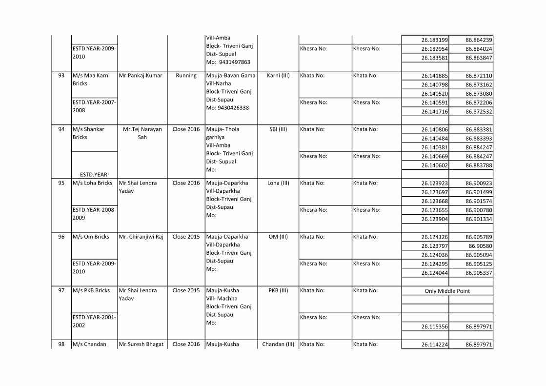
26.183199 86.864239
26.182954 86.864024
26.183581 86.863847
26.141885 86.872110
26.140798 86.873162
26.140520 86.873080
26.140591 86.872206
26.141716 86.872532
26.140806 86.883381
26.140484 86.883393
26.140381 86.884247
26.140669 86.884247
26.140602 86.883788
26.123923 86.900923
26.123697 86.901499
26.123668 86.901574
26.123655 86.900780
26.123904 86.901334
26.124126 86.905789
26.123797 86.90580
26.124036 86.905094
26.124295 86.905125
26.124044 86.905337
26.115356 86.897971
26.114224 86.897971
Only Middle Point
98 M/s Chandan
Bricks
Mr.Suresh Bhagat Close 2016 Mauja-Kusha
Vill- Machha
Block-Triveni Ganj
Dist-Supaul
Mo:
Chandan (III) Khata No: Khata No:
97 M/s PKB Bricks Mr.Shai Lendra
Yadav
Close 2015 Mauja-Kusha
Vill- Machha
Block-Triveni Ganj
Dist-Supaul
Mo:
PKB (III) Khata No: Khata No:
ESTD.YEAR-2001-
2002
Khesra No: Khesra No:
96 M/s Om Bricks Mr. Chiranjiwi Raj Close 2015 Mauja-Daparkha
Vill-Daparkha
Block-Triveni Ganj
Dist-Supaul
Mo:
OM (III) Khata No: Khata No:
ESTD.YEAR-2009-
2010
Khesra No: Khesra No:
95 M/s Loha Bricks Mr.Shai Lendra
Yadav
Close 2016 Mauja-Daparkha
Vill-Daparkha
Block-Triveni Ganj
Dist-Supaul
Mo:
Loha (III) Khata No: Khata No:
ESTD.YEAR-2008-
2009
Khesra No: Khesra No:
94 M/s Shankar
Bricks
Mr.Tej Narayan
Sah
Close 2016 Mauja- Thola
garhiya
Vill-Amba
Block- Triveni Ganj
Dist- Supual
Mo:
SBI (III) Khata No: Khata No:
ESTD.YEAR-
Khesra No: Khesra No:
93 M/s Maa Karni
Bricks
Mr.Pankaj Kumar Running Mauja-Bavan Gama
Vill-Narha
Block-Triveni Ganj
Dist-Supaul
Mo: 9430426338
Karni (III) Khata No: Khata No:
ESTD.YEAR-2007-
2008
Khesra No: Khesra No:
92 M/s BPY Bricks Mr.Bindeshwari
Prasad Yadav
close 2010 Mauja- Thola
garhiya
Vill-Amba
Block- Triveni Ganj
Dist- Supual
Mo: 9431497863
BPY (III) Khata No: Khata No:
ESTD.YEAR-2009-
2010
Khesra No: Khesra No:
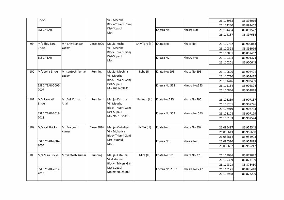
26.113968 86.898016
26.114240 86.897462
26.114454 86.897527
26.114187 86.897654
26.109762 86.900043
26.110398 86.898016
26.109831 86.897462
26.110304 86.901374
26.110201 86.900643
26.110676 86.902421
26.110730 86.902477
26.111446 86.902489
26.111154 86.902824
26.110846 86.902878
26.108239 86.907137
26.108251 86.907776
26.107919 86.907764
26.108108 86.907129
26.108183 86.907574
26.086497 86.955542
26.086643 86.955660
26.086814 86.954903
26.086580 86.954889
26.086657 86.955242
26.119086 86.877077
26.119339 86.877169
26.119303 86.876450
26.119121 86.876448
26.118958 86.877299
103 M/s Mira Bricks Mr.Santosh Kumar Running Mauja- Latauna
Vill-Latauna
Block- Triveni Ganj
Dist-Supaul
Mo: 9570924400
Mira (III) Khata No:301 Khata No:278
ESTD.YEAR-2012-
2013
Khesra No:2057 Khesra No:2176
102 M/s Kali Bricks Mr.Pranjeet
Kumar
Close 2016 Mauja-Muhaliya
Vill- Muhaliya
Block-Triveni Ganj
Dist- Supaul
Mo:
INDIA (III) Khata No: Khata No:297
ESTD.YEAR-2002-
2004
Khesra No: Khesra No:
101 M/s Parwati
Bricks
Mr.Anil Kumar
Anal
Running Mauja- Kushha
Vill-Myurba
Block-Triveni Ganj
Dist-Supaul
Mo: 9661859413
Prawati (III) Khata No:295 Khata No:295
ESTD.YEAR-2012-
2013
Khesra No:553 Khesra No:553
100 M/s Loha Bricks Mr.santosh Kumar
Yadav
Running Mauja- Mochha
Vill-Myurba
Block-Triveni Ganj
Dist-Supaul
Mo:7631409841
Loha (III) Khata No: 295 Khata No:295
ESTD.YEAR-2006-
2007
Khesra No:553 Khesra No:553
99 M/s Shiv Tara
Bricks
Mr. Shiv Nandan
Yadav
Close 2000 Mauja-Kusha
Vill- Machha
Block-Triveni Ganj
Dist-Supaul
Mo:
Shiv Tara (III) Khata No: Khata No:
ESTD.YEAR- Khesra No: Khesra No:
98 M/s Chandan
Bricks
Mr.Suresh Bhagat Close 2016 Mauja-Kusha
Vill- Machha
Block-Triveni Ganj
Dist-Supaul
Mo:
Chandan (III) Khata No: Khata No:
ESTD.YEAR- Khesra No: Khesra No:
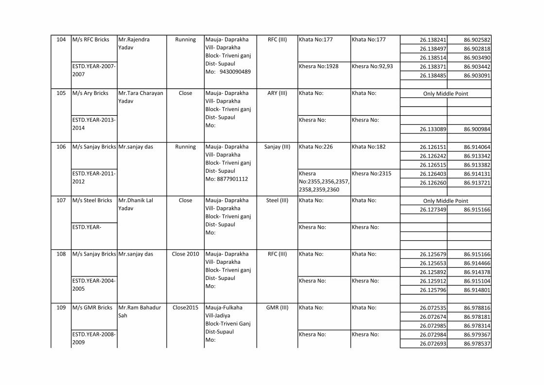
26.138241 86.902582
26.138497 86.902818
26.138514 86.903490
26.138371 86.903442
26.138485 86.903091
26.133089 86.900984
26.126151 86.914064
26.126242 86.913342
26.126515 86.913382
26.126403 86.914131
26.126260 86.913721
26.127349 86.915166
26.125679 86.915166
26.125653 86.914466
26.125892 86.914378
26.125912 86.915104
26.125796 86.914801
26.072535 86.978816
26.072674 86.978181
26.072985 86.978314
26.072984 86.979367
26.072693 86.978537
Only Middle Point
Only Middle Point
109 M/s GMR Bricks Mr.Ram Bahadur
Sah
Close2015 Mauja-Fulkaha
Vill-Jadiya
Block-Triveni Ganj
Dist-Supaul
Mo:
GMR (III) Khata No: Khata No:
ESTD.YEAR-2008-
2009
Khesra No: Khesra No:
107 M/s Steel Bricks Mr.Dhanik Lal
Yadav
Close Mauja- Daprakha
Vill- Daprakha
Block- Triveni ganj
Dist- Supaul
Mo:
Steel (III) Khata No: Khata No:
ESTD.YEAR- Khesra No: Khesra No:
108 M/s Sanjay Bricks Mr.sanjay das Close 2010 Mauja- Daprakha
Vill- Daprakha
Block- Triveni ganj
Dist- Supaul
Mo:
RFC (III) Khata No: Khata No:
ESTD.YEAR-2004-
2005
Khesra No: Khesra No:
105 M/s Ary Bricks Mr.Tara Charayan
Yadav
Close Mauja- Daprakha
Vill- Daprakha
Block- Triveni ganj
Dist- Supaul
Mo:
ARY (III) Khata No: Khata No:
ESTD.YEAR-2013-
2014
Khesra No: Khesra No:
106 M/s Sanjay Bricks Mr.sanjay das Running Mauja- Daprakha
Vill- Daprakha
Block- Triveni ganj
Dist- Supaul
Mo: 8877901112
Sanjay (III) Khata No:226 Khata No:182
ESTD.YEAR-2011-
2012
Khesra
No:2355,2356,2357,
2358,2359,2360
Khesra No:2315
104 M/s RFC Bricks Mr.Rajendra
Yadav
Running Mauja- Daprakha
Vill- Daprakha
Block- Triveni ganj
Dist- Supaul
Mo: 9430090489
RFC (III) Khata No:177 Khata No:177
ESTD.YEAR-2007-
2007
Khesra No:1928 Khesra No:92,93

109 Mr.Ram Bahadur
Sah
Close2015 Mauja-Fulkaha
Vill-Jadiya
Block-Triveni Ganj
Dist-Supaul
Mo:
GMR (III)
ESTD.YEAR-2008-
2009
Khesra No: Khesra No: