distances between us portstugandbargesolutions.com/docs/nautical_distances.pdfdistances between...
TRANSCRIPT

DistancesBetweenUnited StatesPorts
2002 (9th) Edition
U.S. DEPARTMENT OF COMMERCEDonald L. Evans, Secretary
National Oceanic and Atmospheric Administration (NOAA)Vice Admiral Conrad Lautenbacher, Jr., USN (Ret), Under Secretary of Commerce
for Oceans and Atmosphere, and Administrator, NOAA
National Ocean ServiceMargaret A. Davidson, Acting Assistant Administrator for Ocean Services
and Coastal Zone Management
Washington, DCDistributed by the National Ocean Service
II

Preface
Distances Between United States Ports is published by the Office of Coast Survey, National Ocean Service(NOS), National Oceanic and Atmospheric Administration (NOAA), pursuant to the Act of 6 August 1947 (33 U.S.C.883a and b), and the Act of 22 October 1968 (44 U.S.C. 1310).
Distances Between United States Ports contains distances from a port of the United States to other ports in theUnited States, and from a port in the Great Lakes in the United States to Canadian ports in the Great Lakes and St. Law-rence River.
Distances Between Ports, Publication 151, is published by National Imagery and Mapping Agency (NIMA) anddistributed by NOS. NIMA Pub. 151 is international in scope and lists distances from foreign port to foreign port and fromforeign port to major U.S. ports. The two publications, Distances Between United States Ports and Distances BetweenPorts, complement each other.
This volume of Distances Between United States Port cancels the 1993 (8th) edition.
Mariners and other are urged to promptly report errors in this publication to NOAA. These reports should be sent toChief, Coast Pilot Branch (N/CS51)Office of Coast SurveyNational Ocean Service, NOAA1315 East-West HighwaySilver Spring, MD 20910-3282.
III

IV
Record of Changes
ChangeNumber
FromLNM No.
EnteredBy
DateEntered
ChangeNumber
FromLNM No.
EnteredBy
DateEntered

Contents
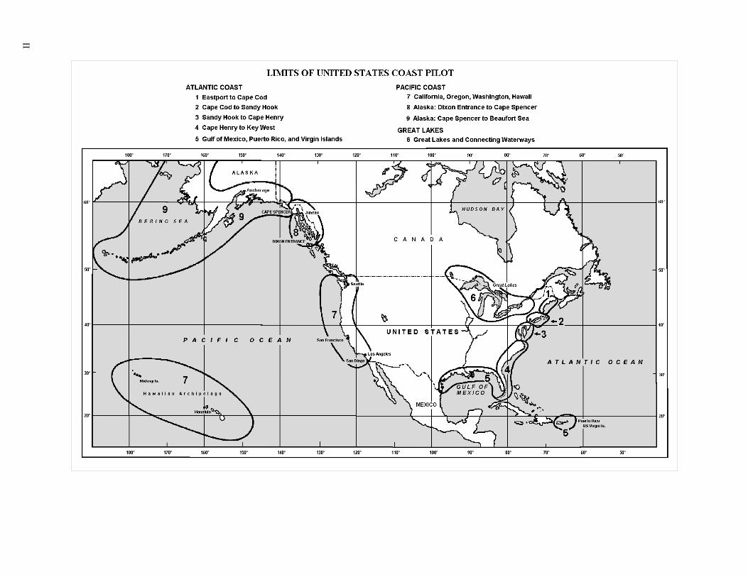
General Information . . . . . . . . . . . . . . . . . . . . . . . . . . . . . . . . . 1
Atlantic DistancesAtlantic Ocean distances for deep-draft vessels – Montreal, Canada to Panama Canal . . . . . . . . T–1Gulf of Maine distances – Calais, ME, to Cape Cod, MA . . . . . . . . . . . . . . . . . . . . T–2Coastwise distances – Cape Cod, MA, to New York, NY . . . . . . . . . . . . . . . . . . . . T–3Inside-route distances – South side of Long Island – Greenport, NY, to East Rockaway Inlet, NY . . . . T–4Distances on Hudson River – New York, NY, to Troy Lock, NY . . . . . . . . . . . . . . . . . T–5Coastwise distances – New York, NY, to Chesapeake Bay entrance, VA . . . . . . . . . . . . . . T–6Distances by Intracoastal Waterway – Manasquan Inlet, NJ, to Cape May Canal, NJ . . . . . . . . . T–7Distances on Delaware Bay and River . . . . . . . . . . . . . . . . . . . . . . . . . . . T–8Chesapeake Bay distances . . . . . . . . . . . . . . . . . . . . . . . . . . . . . . . . T–9Distances on Potomac River. . . . . . . . . . . . . . . . . . . . . . . . . . . . . . . T–10Coastwise distances – Norfolk, VA, to Key West, FL . . . . . . . . . . . . . . . . . . . . . T–11Inside-route distances – Norfolk, VA, to Fernandina Beach, FL . . . . . . . . . . . . . . . . . T–12Inside-route distances – Fernandina Beach, FL to Key West, FL . . . . . . . . . . . . . . . . T–13Distances on St. Johns River, FL . . . . . . . . . . . . . . . . . . . . . . . . . . . . . T–14Gulf of Mexico – Key West, FL to Brownsville, TX . . . . . . . . . . . . . . . . . . . . . T–15Coastwise and inside-route distances – Key West, FL, to Apalachicola, FL . . . . . . . . . . . . T–16Distances by Intracoastal Waterway – Apalachicola, FL, to Brownsville, TX . . . . . . . . . . . T–17Puerto Rico and Virgin Islands distances . . . . . . . . . . . . . . . . . . . . . . . . . . T–18
Mississippi River SystemsMississippi River . . . . . . . . . . . . . . . . . . . . . . . . . . . . . . . . . . . T–19Ohio River . . . . . . . . . . . . . . . . . . . . . . . . . . . . . . . . . . . T–19, T–20Tennessee River . . . . . . . . . . . . . . . . . . . . . . . . . . . . . . . . . . . T–20Missouri River . . . . . . . . . . . . . . . . . . . . . . . . . . . . . . . . . . . . T–20Illinois Waterway . . . . . . . . . . . . . . . . . . . . . . . . . . . . . . . . . . . T–21
Great Lakes and New York State Waterways DistancesDistances on the Great Lakes . . . . . . . . . . . . . . . . . . . . . . . . . . . . . . T–22Distances on Lake Ontario and St. Lawrence River. . . . . . . . . . . . . . . . . . . . . . T–23Distances on Lake Erie, and St. Clair, Detroit and Niagara Rivers . . . . . . . . . . . . . . . . T–24Distances on Lake Huron and St. Marys River . . . . . . . . . . . . . . . . . . . . . . . T–25Distances on Lake Michigan . . . . . . . . . . . . . . . . . . . . . . . . . . . . . . T–26Distances on Lake Superior . . . . . . . . . . . . . . . . . . . . . . . . . . . . . . . T–27Distances on New York State Waterways. . . . . . . . . . . . . . . . . . . . . . . . . . T–28
Pacific DistancesDistances in Panama Canal . . . . . . . . . . . . . . . . . . . . . . . . . . . . . . . T–29Pacific Ocean distances . . . . . . . . . . . . . . . . . . . . . . . . . . . . . . . . T–30Pacific Coast – San Diego, CA, to Cape Flattery, WA . . . . . . . . . . . . . . . . . . . . . T–31
V

San Francisco Bay Area . . . . . . . . . . . . . . . . . . . . . . . . . . . . . . . . T–32Distances on Columbia River System . . . . . . . . . . . . . . . . . . . . . . . . . . . T–33Distances in Strait of Juan de Fuca and Strait of Georgia . . . . . . . . . . . . . . . . . . . T–34Hawaii distances . . . . . . . . . . . . . . . . . . . . . . . . . . . . . . . . . . . T–35Gulf of Alaska distances . . . . . . . . . . . . . . . . . . . . . . . . . . . . . . . . T–36Inside-passage distances – Seattle, WA, to Cape Spencer, AK . . . . . . . . . . . . . . . . . T–37Distances on Yukon River, AK. . . . . . . . . . . . . . . . . . . . . . . . . . . . . . T–38Bering Sea and Arctic Ocean distances . . . . . . . . . . . . . . . . . . . . . . . . . . T–39
Miscellaneous TablesTable for estimating time of transit . . . . . . . . . . . . . . . . . . . . . . . . . . . . T–40Measurement and Conversion Factors . . . . . . . . . . . . . . . . . . . . . T–41 through T–44Metric Style Guide . . . . . . . . . . . . . . . . . . . . . . . . . . . . . . . . . . T–45
Appendix . . . . . . . . . . . . . . . . . . . . . . . . . . . . . . . . . . (follows tables)
Index . . . . . . . . . . . . . . . . . . . . . . . . . . . . . . . . . . (follows appendix)
VI

GENERAL INFORMATION
(1) Distance Between United States Ports con-tains distances from a port of the United States to otherports in the United States, and from a port in the GreatLakes in the United States to Canadian Ports in theGreat Lakes and St Lawrence River. These distancesare measured along navigable tracklines.
(2) General.–Departure and arrival geographic co-ordinates, where listed, are for a centrally located pierinside the port.
(3) Distances given are given in nautical miles fortables relating to distances along the coasts. Generallyspeaking, distances in tables of the Mississippi RiverSystem, the Great Lakes, and other inland waters are instatue miles. The individual tables show in their head-ing, what the units of the table are in, i.e., nauticalmiles or statue miles.
(4) International nautical mile.–The nautical mileis a special unit employed for marine and aerial naviga-tion to express distance. The International nauticalmile is exactly 1,852 meters in length. 1,852 meters =6,076.11549 U.S. feet.
(5) Each distance between the two ports concernedis along the shortest route that safe navigation permits.The navigator must make his own adjustments forweather or prevailing currents.
(6) Junction Points.–These are positions wheretwo or more routes converge; they are shown in CAPI-TAL LETTERS in the tables. Distances between portslisted in different tables can be obtained by adding therespective distances to the junction points. Where aport is listed in more than one table, additional combi-nations of distances can also be obtained by using theport as a common reference point. (See examples thatfollow.)
(7) Foreign Ports.–Distances Between Ports,Pub. 151, is published by National Imagery andMapping Agency (NIMA) and distributed by Na-tional Ocean Service. NIMA Pub 151 is Internationalin scope and lists distances from foreign port to foreignport, and from foreign port to major United Statesports. The two publications, Distances BetweenUnited States Ports and Distances Between Ports,complement each other. See Example 20.
(8) Examples.–The following examples will illus-trate the use of the tables. The index will show in whichtable the ports are listed.
Ports in the same table
(9) Example 1.–Find the distance from New York,NY to Charleston, SC.
(10) In Table T–1 find New York, NY, in the list ofcities along the left edge of the table, and Charleston,SC, in the list of cities along the top of the table. The in-tersection of the row and column will contain the dis-tance (630 miles) between these two parts.
Use of Junction and common reference points
(11) Example 2.–Find the distance from Bridgeport,CT, to Albany, NY:
(12) Bridgeport to New York (table T–3) . . . . . 52(13) New York to Albany (table T–5) . . . . . . . 126(14) Bridgeport to Albany . . . . . . . . . . . . . . . . 178
(15) Example 3.–Find the distance from New York,NY, to Miami, FL, via the Intracoastal Waterway:
(16) New York to Chesapeake and Delaware Canaleast entrance (table T–7) . . . . . . . . . . . . . . . . . . . 190
(17) East entrance of Chesapeake and Delaware Ca-nal Norfolk, VA (table T–9) . . . . . . . . . . . . . . . . 209
(18) Norfolk to Miami (table T–13). . . . . . . . . 947(19) New York to Miami. . . . . . . . . . . . . . . . 1,346
Alternate routes
(20) Example 4.–Find the distance from Portland,ME, to New York, NY, by two routes:
(21) 1. Outside, via Nantucket Shoals:(22) Portland to New York (table T–1) . . . . . . 426(23) 2. Via Cape Code Canal and Long Island Sound:(24) Portland to Cape Cod Canal E entrance (table
T–2) . . . . . . . . . . . . . . . . . . . . . . . . . . . . . . . . . . . 118(25) Cape Cod Canal E entrance to New York (table
T–3) . . . . . . . . . . . . . . . . . . . . . . . . . . . . . . . . . . . 182(26) Portland to New York . . . . . . . . . . . . . . . . 300
(27) Example 5.–Find the distance from Boston,MA, to Baltimore, MD, by two routes:
(28) 1. Outside, via Nantucket Shoals and Chesa-peake Bay entrance:
(29) Boston to Baltimore (table T–1). . . . . . . . 694(30) 2. Via Cape Cod Canal and Chesapeake and
Delaware Canal:(31) Boston to Cape Cod Canal E entrance (table
T–2) . . . . . . . . . . . . . . . . . . . . . . . . . . . . . . . . . . . . 52(32) Cape Cod Canal E entrance to Montauk Point,
NY (table T–3) . . . . . . . . . . . . . . . . . . . . . . . . . . . 76(33) Montauk Point to Chesapeake and Delaware
Canal east entrance (table T–6). . . . . . . . . . . . . . 263(34) East entrance of Chesapeake and Delaware Ca-
nal to Baltimore (table T–9) . . . . . . . . . . . . . . . . . 62(35) Boston to Baltimore . . . . . . . . . . . . . . . . . 453
Harbor Entrances
(36) Example 6.–Find the distance from San Fran-cisco entrance buoy, CA, to Coos Bay entrance buoy,OR:
(37) San Francisco to Coos Bay (city) (table T–31). . . . . . . . . . . . . . . . . . . . . . . . . . . . . . . . . . . . . . . 396
(38) San Francisco entrance buoy to San Francisco,15 miles, plus Coos Bay entrance buoy to Coos Bay(city), 13 miles (table T–31) . . . . . . . . . . . . . . . . -28
1

(39) San Francisco entrance buoy to Coos Bay en-trance buoy . . . . . . . . . . . . . . . . . . . . . . . . . . . . . 368
Foreign ports
(40) Example 7.–Find the distance from Beaumont,TX to Lisboa, Portugal:
(41) Beaumont, TX, to Straits of Florida (tableT–15) . . . . . . . . . . . . . . . . . . . . . . . . . . . . . . . . . . 726
(42) Straits of Florida to Lisboa, Portugal (Pub. 151)3,831
(43) Beaumont to Lisboa, Portugal . . . . . . . . 4,557
2 GENERAL INFORMATION

T -
1
ATLANTIC OCEAN DISTANCESMONTREAL, CANADA to the PANAMA CANAL
(Nautical Miles)
PA
NA
MA
CA
NA
L (P
acifi
c)
Pan
ama
Can
al (
Atla
ntic
)
YU
CA
TA
N C
HA
NN
EL
San
Jua
n, P
R
Cor
pus
Chr
isti,
TX
Gal
vest
on, T
X
Por
t Art
hur,
TX
New
Orle
ans
(via
SW
Pas
s)
Mob
ile, A
L
Pen
saco
la, F
L
Tam
pa, F
L
ST
RA
ITS
OF
FLO
RID
A
Key
Wes
t, F
L
Jac
kson
vil le
, FL
Sav
anna
h, G
A
Cha
rlest
on, S
C
Wilm
ingt
on, N
C
Dia
mon
d S
hoal
s
Nor
folk
, VA
Che
sape
ake
Bay
Ent
ranc
e
Bal
timor
e, M
D
Phi
lade
lphi
a, P
A
New
Yor
k, N
Y
Nan
tuck
et S
hoal
s
Bos
ton,
MA
Por
tland
, ME
Gut
of C
anso
(Lo
ck)
Cab
ot S
trai
t
MONTREAL, QUE* (St. Lambert Lock)
3249 3203 2730 2445 3347 3242 3240 3080 3011 2977 2772 2540 2479 2172 2088 2014 1948 1729 1716 1689 1838 1682 1534 1311 1318 1276 717 681
Cabot Strait 45�07.0’N., 60�17.0’W.
2568 2522 2049 1764 2666 2561 2559 2399 2330 2296 2091 1859 1798 1491 1407 1333 1267 1048 1035 1008 1157 1001 853 630 637 595 120 -
Gut of Canso (Lock) 45�39.0'N., 61�25.0'W.
2465 2419 1937 1669 2558 2453 2451 2291 2222 2188 1983 1751 1690 1379 1295 1221 1155 936 923 896 1046 890 742 519 526 484 -
Portland, ME 43�39.4'N., 70�14.7'W.
2235 2189 1629 1531 2255 2150 2148 1988 1919 1885 1680 1448 1387 1071 987 913 847 628 611 584 734 575 426 203 100 -
Boston, MA 42�22.0'N., 71�03.0'W.
2195 2149 1589 1486 2215 2110 2108 1948 1879 1845 1640 1408 1347 1031 947 873 807 588 571 544 694 535 386 163 -
NANTUCKET SHOALS 40�30.0'N., 69�25.0'W.
2032 1986 1426 1334 2052 1947 1945 1785 1716 1682 1477 1245 1184 868 784 710 644 425 408 381 531 372 223 -
NEW YORK, NY 40�42.0'N., 74�01.0'W.
2018 1972 1346 1399 1977 1872 1870 1710 1641 1607 1402 1170 1109 788 704 630 564 345 294 267 417 240 -
Philadelphia, PA 39�56.8'N., 75�08.3'W.
2001 1955 1323 1395 1954 1849 1847 1687 1618 1584 1379 1147 1086 765 681 607 541 322 269 242 392 -
Baltimore, MD 39�16.0'N., 76�34.5'W.
1950 1904 1268 1375 1899 1794 1792 1632 1563 1529 1324 1092 1031 710 626 552 486 267 173 150 -
CHESAPEAKE BAY ENTRANCE 36�56.3'N., 75�58.6'W.
1800 1754 1118 1225 1749 1644 1642 1482 1413 1379 1174 942 881 560 476 402 336 117 27 -
Norfolk, VA 36�50.9'N., 76�17.9'W.
1827 1781 1145 1252 1776 1671 1669 1509 1440 1406 1201 969 908 587 503 429 363 144 -
Diamond Shoals 35�08.0'N., 75�15.0'W.
1683 1637 1001 1114 1632 1527 1525 1365 1296 1262 1057 825 764 443 359 285 219 -
Wilmington, NC 34�14.0'’N., 77�57.0'W.
1655 1609 904 1153 1535 1430 1428 1268 1199 1165 960 728 667 315 227 151 -
Charleston, SC 32�47.2'N., 79�55.2'W.
1609 1563 809 1138 1440 1335 1333 1173 1104 1070 865 633 572 197 102 -
Savannah, GA 32�05.0'N., 81�05.7'W.
1610 1564 780 1156 1411 1306 1304 1144 1075 1041 836 604 543 145 -
Jacksonville, FL 30�19.2'N., 81�39.0'W
1559 1513 699 1121 1330 1225 1223 1063 994 960 755 523 462 -
Key West, FL 24�33.7'N., 81�48.5'W.
1106 1060 251 966 880 775 773 613 544 510 305 73 -
STRAITS OF FLORIDA 24�25.0'N., 83�00.0'W.
1047 1001 192 1017 807 702 700 540 471 437 232 -
All tabular distances are by outside routes whichcan be used by the deepest-draft vessel that thelisted ports can accommodate. Lighter-draftvessels can save considerable mileage bytransiting Canso Lock (Canada), the Cape CodCanal (Massachusetts), and the Chesapeake andDeleware Canal (Deleware-Maryland); see thedetailed tables. Gulf of Mexico distances arethrough the Shipping Safety Fairways.
Tampa, FL 27�56.5'N., 82�26.7'W.
1259 1213 404 1249 810 703 697 502 389 347 -
Pensacola, FL 30�24.0'N., 87�13.0'W.
1388 1342 533 1448 618 509 504 288 89 -
Mobile, AL 30�42.5'N., 88�02.5'W.
1417 1371 562 1448 605 496 491 269 -
NEW ORLEANS (via SW Pass) 29�57.0'N., 90�03.7'W.
1442 1396 587 1557 555 446 441 -
Port Arthur, TX 1533 1487 691 1717 249 89 -
Galveston, TX 29�19.0'N., 94�47.0'W.
1539 1493 696 1719 207 -
Corpus Christi, TX 27�48.8'N., 97�24.0'W.
1595 1549 769 1824 -
San Juan, PR 18�27.8'N., 66�06.7'W.
1036 990 1111 -
YUCATAN CHANNEL 21�50.0'’N., 85�03.0'W.
855 809 -
Panama Canal (Atlantic) 9�23.5'N., 79�55.3'W.
46 -
PANAMA CANAL (Pacific) 8�53.0'N., 79�31.0'W.
- * For Quebec City, Canada - subtract 139 miles

T -
2GULF OF MAINE DISTANCESCALAIS, MAINE to CAPE COD, MASSACHUSETTS
(Nautical Miles)
Nan
tuck
et S
hoal
s
Pro
vinc
etow
n, M
E
Cap
e C
od C
anal
E E
nter
ance
Ply
mou
th, M
A
Scitu
ate,
MA
Bos
ton,
MA
Lyn
n, M
A
Mar
bleh
ead,
MA
Sal
em, M
A
Glo
uces
ter,
MA
Roc
kpor
t, M
A
New
bury
port
, MA
Por
tsm
outh
, NH
Yor
k H
arbo
r, M
E
Por
tlan
d, M
E
Aug
usta
, ME
Bat
h, M
E
Wis
cass
et, M
E
Boo
thba
y H
arbo
r, M
E
Ban
gor,
ME
Buc
kspo
rt, M
E
Sear
spor
t, M
E
Roc
klan
d, M
E
Sto
ning
ton,
ME
Buc
k H
arbo
r, M
E
Bar
Har
bor,
ME
Jone
spor
t, M
E
Mac
hias
port
, ME
Lub
ec, M
E
Eas
tpo
ME
rt,
Cal
ais,
ME
Calais, ME 45�11.4'N., 67�16.7'W.
312 258 270 268 259 265 261 251 252 245 236 241 230 222 198 214 187 189 168 176 159 152 145 118 125 98 66 61 26 24 -
Eastport, ME 44�54.3'N., 66�59.0'W.
297 243 255 253 244 250 246 236 237 230 221 226 216 208 183 200 173 175 153 162 145 137 130 102 109 83 42 46 3 -
Lubec, ME 44�51.7'N., 66�59.0'W.
286 232 244 242 233 239 235 225 226 219 210 215 204 196 172 188 161 162 142 150 133 126 118 91 98 72 40 35 -
Machiasport, ME 44�41.9'N., 67�23.6'W.
271 214 226 224 215 221 217 207 208 200 192 197 186 178 153 169 142 144 123 132 115 107 100 73 80 52 20 -
Jonesport, ME 44�31.6'N., 67�37.0'W.
257 197 209 206 196 203 198 188 189 182 173 178 167 159 135 149 122 124 105 113 96 89 82 53 60 34 -
Bar Harbor, ME 44�23.5'N., 68�12.0'W.
243 179 190 188 177 184 179 169 170 163 154 159 148 140 115 130 103 105 86 94 77 70 62 33 39 -
Buck Harbor, ME 44 �20.3'N., 68�44.2'W.
237 165 176 174 159 162 157 148 149 138 131 137 123 114 85 94 67 68 57 39 22 16 22 16 -
Stonington, ME 44�09.2'N., 68�39.8'W.
226 155 165 163 155 158 153 143 145 133 126 132 119 109 81 90 63 64 53 47 30 24 20 -
Rockland, ME 44�06.0'N., 69�05.5'W.
223 148 160 155 142 147 142 132 133 126 115 118 107 99 71 86 59 62 42 50 33 23 -
Searsport, ME 44�27.0'N., 68�54.0'W.
242 166 178 174 161 166 161 151 152 145 134 137 126 118 90 105 78 80 61 30 13 -
Bucksport, ME 44�34.3'N., 68�48.0'W.
250 175 187 182 169 174 169 159 160 153 143 145 135 126 98 113 86 89 70 17 -
Bangor, ME 44�47.7'N., 68�46.3'W.
267 192 204 199 186 191 186 176 177 170 160 162 151 144 115 131 104 106 87 -
Boothbay Harbor, ME 43�51.0'N., 69�37.6'W.
207 119 130 125 112 115 110 101 102 95 84 86 74 64 36 50 23 21 -
Wiscasset, ME 43�59.5'N., 69�40.1'W.
217 127 139 133 120 123 118 109 110 103 92 94 82 72 44 57 30 -
Bath, ME 43�54.5'N., 69�48.7'W.
213 123 137 129 115 119 114 104 105 98 88 89 78 67 40 27 -
Augusta, ME 44�18.9'N., 69�46.4'W.
240 150 164 156 142 146 141 131 132 125 115 116 104 94 66 -
Portland, ME 43�39.4'N., 70�14.7'W.
203 107 118 112 97 100 95 86 87 79 66 67 56 43 -
York Harbor, ME 43�07.9'N., 70�38.6'W.
182 75 83 75 60 63 58 48 49 42 29 25 11 -
Portsmouth, NH 43�04.6'N., 70�44.5'W.
180 73 81 73 58 61 56 46 47 40 27 22 -
Each distance is by the shortest routethat safe navigation permits between thetwo ports concerned. Vessels standingalong the coast must make their ownadjustments for non-direct routes. Forexample, the table shows a distance of214 miles by direct route fromMachiasport to Provincetown; thedistance via Matincus Rock and CapeAnn is 235 miles. Distances fromEastport to Machiasport and other portssouthward are via deep Head HarborPassage, which is 8 miles farther thanvia shallow Lubec Channel.
Newburyport, MA 42�48.8'N., 70�52.4'W.
171 63 72 64 48 51 47 37 38 31 16 -
Rockport, MA 42�40.0'N., 70�36.5'W.
157 49 58 50 34 37 33 23 24 17 -
Gloucester, MA 42�36.6'N., 70�39.6'W.
155 45 52 43 26 26 22 11 12 -
Salem, MA 42�31.3'N., 70�52.5'W.
159 49 53 45 24 27 18 5 -
Marblehead, MA 42�30.2'N., 70�50.7'W.
156 45 48 39 22 19 14 -
Lynn, MA 42�27.3'N., 70�56.6'W.
159 47 48 40 22 13 -
Boston, MA 42�22.0'N., 71�03.0'W.
163 49 52 40 21 -
Scituate, MA 42�11.9'N., 70�43.5'W.
143 29 29 20 -
Plymouth, MA 41�57.6'N., 70�39.8'W.
144 26 20 -
CAPE COD CANAL E. ENT. 41�46.8'N., 70�29.0'W.
144 22 -
Provincetown, ME 42�02.5'N., 70�10.0'W.
132 -
NANTUCKET SHOALS 40�30.0'N., 69�25.0'W.
-

T -
3
COASTWISE DISTANCESCAPE COD, MA, to NEW YORK, NY
(Nautical Miles)
Po
rt N
ewar
k, N
J
Eli
zab
eth
po
rt, N
J
Per
th A
mb
oy
, N
J
New
Yo
rk C
ity
, N
Y
Mo
nta
uk
Po
int,
NY
Po
rt J
effe
rso
n, N
Y
Gre
enp
ort
, N
Y
Sag
Har
bo
r, N
Y
Mo
nta
uk
, N
Y
Sta
mfo
rd, C
T
So
uth
No
rwal
k, C
T
Bri
dg
epo
rt, C
T
Str
atfo
rd, C
T
New
Hav
en, C
T
Har
tfo
rd, C
T
New
Lo
nd
on
, C
T
Sto
nin
gto
n, C
T
Gre
at S
alt
Po
nd
, R
I
Pro
vid
ence
, R
I
Fal
l R
iver
, M
A
New
po
rt, R
I
New
Bed
ford
, M
A
Wo
od
s H
ole
, M
A
Vin
eyar
d H
aven
, M
A
Nan
tuck
et, M
A
Nan
tuck
et S
ho
als,
MA
Cap
e C
od
Can
al E
. E
nt.
CAPE COD CANAL E ENT. 41�46.8'N., 70�29.0W.
193 191 202 182 76 134 99 100 85 152 151 138 132 127 140 89 77 66 74 69 54 31 22 43 69 144 -
NANTUCKET SHOALS, MA 40�30.0N., 69�25.0'W.
227 225 223 223 113 178 142 143 127 196 195 182 176 171 187 136 126 114 131 126 111 111 92 88 85 -
Nantucket, MA 41�17.2'N., 70�05.7W.
208 206 216 196 89 149 113 114 99 167 166 153 147 140 155 103 92 80 91 77 71 53 33 29 -
Vineyard Haven, MA 41�27.3'N., 70�35.8'W.
183 181 191 171 63 123 87 88 74 141 140 127 121 114 129 77 67 54 65 51 45 28 7 -
Woods Hole, MA 41�31.4'N., 70�40.4'W.
178 176 186 166 59 118 82 83 69 136 135 123 117 109 125 72 61 50 57 44 38 15 -
New Bedford, MA 41�38.1'N., 70�55.1'W.
178 176 186 166 60 118 80 81 66 136 135 122 113 111 124 74 58 48 58 54 38 -
Newport, RI 41�29.8'N., 71�19.8'W.
151 149 159 139 35 91 56 57 42 109 108 95 90 84 98 48 34 23 21 16 -
Fall River, MA 41�42.4'N., 71�09.8'W.
166 164 174 154 51 107 71 72 58 125 124 110 105 100 113 63 49 38 21 -
Providence, RI 41�48.5'N., 71�24.0'W.
171 169 179 159 56 112 76 77 63 130 129 115 110 105 118 68 55 43 -
Great Salt Pond, RI 41�11.1'N., 71�34.9'W.
133 131 141 121 15 74 37 39 23 92 91 78 72 65 80 29 19 -
Stonington, CT 41�19.9'N., 71�54.6'W.
121 119 129 109 19 61 28 29 18 79 77 64 59 52 66 12 -
New London, CT 41�21.4'N., 72�05.4'W.
116 114 124 104 28 56 25 27 20 74 73 60 54 49 62 -
Hartford, CT 41�45.0'N., 72�39.0'W.
143 141 151 131 75 84 62 64 66 102 101 86 81 74 -
New Haven, CT 41�17.4'N., 72�54.5'W.
80 78 88 68 62 23 47 49 51 37 36 25 15 -
Stratford, CT 41�11.3'N., 73�07.3'W.
69 67 77 57 65 15 52 54 56 27 26 10 -
Bridgeport, CT 41�10.3'N., 73�10.8'W.
64 62 72 52 74 15 58 60 62 22 21 -
South Norwalk, CT 41�05.7'N., 73�24.7'W.
52 50 60 40 84 23 71 73 75 11 -
Stamford, CT 41�01.8'N., 73�32.3'W.
45 43 53 33 85 24 72 74 76 -
Montauk, NY 41�02.8'N., 71�57.5'W.
117 115 125 105 16 58 22 21 -
Sag Harbor, NY 41�00.2'N., 72�17.7'W.
115 113 123 103 32 56 11 -
Greenport, NY 41�06.0'N., 72�21.5'W.
114 112 122 102 30 54 -
Port Jefferson, NY 40�57.0'N., 73�04.5'W.
64 62 72 52 68 -
MONTAUK POINT, NY 41�01.7'N., 71�47.3'W.
126 124 123 20 -
NEW YORK CITY, NY 40�42.0'N., 74�01.0'W.
12 10 20 - Ambrose Light (40�27.5'N., 73�49.9'W.) to New York (The Battery), 20.7 miles.
Perth Amboy, NJ 40�30.3'N., 74�15.7'W.
15 10 -
Elizabethport, NJ 40�38.8'N., 74�11.2'W.
5 -
Port Newark, NJ 40�41.8'N., 74�09.0'W. -

T -
4INSIDE-ROUTE DISTANCESSOUTH SIDE OF LONG ISLAND
GREENPORT, NY, to EAST ROCKAWAY INLET, NY(Nautical Miles)
Man
asqu
an I
nlet
, NJ
*
New
Yor
k (T
he B
atte
ry)
*
Roc
kaw
ay P
oint
*
Eas
t Roc
kaw
ay I
nlet
Lon
g B
each
Free
port
Jone
s In
let
Jone
s B
each
Am
ityv
ille
Bab
ylon
Fir
e Is
land
Inl
et
Bay
Sho
re
Patc
hogu
e
Bel
lpor
t
Mor
iche
s In
let
Wes
tham
pton
Bea
ch
Shi
nnec
ock
Inle
t
Shi
nnec
ock
Can
al, N
. end
Riv
ersi
de
Sag
Har
bor
Gre
enpo
rt
Greenport 41�06.0'N., 72�21.5'W.
116 107 94 85 80 77 76 72 66 61 62 57 48 42 34 28 21 16 21 11 -
Sag Harbor 41�00.2'N., 72�17.7'W.
117 108 95 86 81 78 77 73 67 62 63 58 49 43 35 29 22 17 22 -
Riverside 40�55.0'N., 72�39.4'W.
108 99 86 77 72 69 68 64 58 53 54 49 40 34 26 20 13 8 -
Shinnecock Canal 40�53.9'N., 72�30.3'W.
100 91 78 69 64 61 60 56 50 45 46 41 32 26 18 12 5 -
Shinnecock Inlet 40�50.3'N., 72�28.6'W.
97 88 75 66 61 58 58 54 47 42 44 39 29 23 15 9 -
Westhampton Beach 40�48.2'N., 72�38.4'W.
89 80 67 58 53 49 49 45 39 34 35 30 21 15 7 -
Moriches Inlet 40�45.8'N., 72�45.3'W.
85 76 63 54 49 46 45 42 35 30 32 27 17 11 -
Bellport 40�45.1'N., 72�56.0'W
75 66 53 44 38 35 35 31 24 19 21 16 6 -
Patchogue 40�45.5'N., 73�01.2'W.
72 63 50 41 36 32 32 28 22 17 18 13 -
Bay Shore 40�42.8'N., 73�14.2'W.
60 51 38 29 24 21 21 17 10 5 9 -
Fire Island Inlet 40�37.8'N., 73�18.6'W.
60 51 38 29 24 21 20 16 12 8 -
Babylon 40�41.2'N., 73�18.9'W.
57 48 35 26 21 18 17 13 6 -
Amityville 40�39.6'N., 73�24.8'W.
51 42 29 20 15 12 11 7 -
Jones Beach 40�36.2'N., 73�30.8'W.
44 35 22 13 8 4 4 -
Jones Inlet 40�34.4'N., 73�34.9'W.
41 32 19 10 5 4 -
Freeport 40�37.6'N., 73�34.9'W.
42 33 20 11 6 -
Long Beach 40�35.7'N., 73�39.4'W.
36 27 14 5 -
East Rockaway 40�34.9N., 73�45.4'W.
31 22 9 -
Rockaway Point * 40�32.4'N., 73�56.5'W.
27 13 -
NEW YORK (THE BATTERY) * 40�42.0'N., 74�01.0'W.
40 -
Manasquan Inlet, NJ * 40�06.1'N., 74�01.9'W.
-
* Outside distances westward of East Rockaway Inlet

T -
5
DISTANCES ON HUDSON RIVERNEW YORK, NY, to TROY LOCK, NY
(Nautical Miles)
Tro
y L
ock
Wat
ervl
iet
Tro
y
Ren
ssel
aer
Alb
any
Coe
yman
s
Cox
sack
ie
Ath
ens
Hud
son
Cat
skil
l
Sau
gert
ies
Kin
gsto
n
Hyd
e P
a rk
Pou
ghke
e psi
e
Ne w
burg
h
Wes
t Poi
nt
Pee
kski
ll
Hav
erst
raw
Oss
inin
g
Nya
ck
Tar
ryto
wn
Yon
kers
New
Yor
k (T
he B
atte
ry)
NEW YORK (THE BATTERY) 40�42.0'N., 74�01.0'W.
134 132 132 126 126 115 108 102 102 99 89 80 71 66 53 45 38 33 29 25 24 16 -
Yonkers 40�56.1'N., 73�54.3'W.
118 116 116 110 110 100 93 86 86 83 74 64 55 50 37 29 23 18 14 10 9 -
Tarrytown 41�04.7'N., 73�52.2'W.
110 108 108 102 102 92 85 78 78 75 66 56 47 42 29 21 15 9 6 2 -
Nyack 41�05.4'N., 73�54.9'W.
110 108 108 102 102 92 85 78 78 75 66 57 48 43 29 22 15 10 6 -
Ossining 41�09.6'N., 73�52.3'W.
106 104 104 98 98 88 80 74 74 71 62 52 43 38 25 17 11 5 -
Haverstraw 41�11.8'N., 73�57.5'W.
102 100 100 94 94 84 76 70 70 67 58 48 39 34 21 13 6 -
Peekskill 41�17.3'N., 73�56.0'W.
96 94 94 88 88 78 71 64 64 61 52 43 34 29 15 8 -
West Point 41�23.1'N., 73�57.3'W
89 87 87 81 81 70 63 57 57 54 45 35 26 21 8 -
Newburgh 41�30.1'N., 74�00.3'W.
81 79 79 73 73 62 55 49 49 46 37 27 18 13 -
Poughkeepsie 41�42.3'N., 73�56.5'W.
68 66 66 60 60 49 42 36 36 33 24 14 5 -
Hyde Park 41�47.3'N., 73�56.9'W.
63 61 61 55 55 44 37 31 31 28 19 9 -
Kingston 41�55.1'N., 73�59.0'W.
56 54 54 48 48 38 30 24 24 21 12 -
Saugerties 42�04.4'N., 73�56.7'W.
46 44 44 38 38 28 21 14 14 11 -
Catskill 42�13.0'N., 73�52.1'W.
37 35 35 29 29 19 11 5 5 -
Hudson 42�15.3'N., 73�48.1'W.
32 30 30 24 24 14 7 1 -
Athens 42�15.6'N., 73�48.5'W.
32 30 30 24 24 14 6 -
Coxsackie 42�21.0'N., 73�47.6'W.
26 24 24 18 18 7 -
Coeymans 42�28.5N., 73�47.4'W.
18 16 16 10 10 -
Albany 42�37.9'N., 73�45.3'W.
8 6 6 0 -
Rensselear 42�37.9'N., 73�45.1'W.
8 6 6 -
Troy 42�43.7'N., 73�41.8'W.
2 0 -
Watervliet 42�43.7'N., 73�41.9'W.
2 -
Troy Lock 41�45.1'N., 73�41.1'W.
-

T -
6COASTWISE DISTANCENEW YORK, NY, to CHESAPEAKE BAY ENTRANCE, VA
(Nautical Miles)
Che
sape
ake
Bay
Ent
.
Chi
ncot
eagu
e, V
A
Oce
an C
ity, M
D
Indi
an R
iv. I
nlet
, DE
Tre
nton
, NJ
Fmr.
US
Stee
l Bas
in, P
A
Phila
delp
hia,
PA
Che
ster
, PA
Mar
cus
Hoo
k, P
A
Wilm
ingt
on, D
E
C &
D C
anal
Eas
t Ent
.
Ha r
bor
of R
e fug
e , D
E
Del
ewar
e B
ay E
nt.
Ca p
e M
ay H
a rbo
r, N
J
Atla
ntic
City
, NJ
Bar
nega
t Inl
et, N
J
Man
a squ
an I
nle t
, NJ
New
Yor
k, N
Y
Mon
tauk
Poi
nt, N
Y
Nan
tuck
e t S
hoa l
s
NANTUCKET SHOALS 40�30.0'N., 69�25.0'W.
381 328 295 285 400 395 372 356 353 347 336 285 285 271 242 221 212 223 113 -
MONTAUK POINT, NY 41�01.7'N., 71�47.3'W.
322 262 227 209 327 322 299 283 280 274 263 212 212 192 159 131 117 122 -
NEW YORK, NY 40�42.0'N., 74�01.0'W.
267 201 161 145 268 263 240 224 221 215 204 153 153 128 94 63 40 -
Manasquan Inlet, NJ 40�06.9'N., 72�30.3'W.
219 161 121 105 212 207 184 169 165 159 148 98 97 85 52 22 -
Barnegat Inlet, NJ 39�46.0'N., 74�06.3'W.
199 141 101 86 193 188 165 150 146 140 129 79 78 65 32 -
Atlantic City, NJ 39�22.6'N., 74�24.9'W.
171 113 73 57 164 159 136 121 117 111 100 50 49 37 -
Cape May Harbor, NJ 38�57.1'N., 74�52.6'W.
141 80 40 24 131 126 103 88 84 78 67 17 16 -
DELAWARE BAY ENTRANCE 38�50.5'N., 75�03.3'W
155 72 32 15 115 110 87 72 68 62 51 2 -
Harbor of Refuge, DE 38�49.0'N., 75�05.2'W.
155 71 31 14 116 111 88 73 69 63 52 -
C&D CANAL EAST ENT. 39�33.8'N., 75�32.8'W.
206 123 83 66 64 59 36 21 17 11 -
Wilmington, DE 39�43.2'N., 75�31.5'W.
218 134 95 77 54 49 26 11 8 -
Marcus Hook, PA 39�48.2'N., 75�25.2'W.
224 140 101 83 46 41 18 3 -
Chester, PA 39�50.0'N., 75�22.0'W.
227 144 104 86 43 38 15 -
Philadelphia, PA 39�56.8'N., 75�08.3'W.
242 159 119 101 28 23 -
Former US Steel Basin, PA 40�08.2'N., 74�45.3'W.
265 182 142 124 5 -
Trenton, NJ 40�37.6'N., 73�34.9'W.
270 187 147 129 -
Indian River Inlet, DE 38�36.5'N., 75�03.6'W.
118 60 20 -
Ocean City, MD 38�19.6N., 75�05.6'W.
100 41 -
Chincoteague, VA 37º56.1'N., 75º22.8'W.
69 -
CHESAPEAKE BAY ENTRANCE 40�42.0'N., 74�01.0'W.
-
Ambrose Light (40º27.0'N., 73º48.0'W.) To New York, 28 miles.Five Fathom Bank Lighted Buoy F (38º46.8'N., 74º34.5'W.) To Philadelphia, 111 miles.Delaware Lighted Buoy D (38º27.3'N., 74º41.8'W.) To Philadelphia, 116 miles.Chesapeake Light (36º54.3'N., 75º42.8'W.) To Norfolk, 42 miles; to Baltimore, 165 miles.

T -
7
DISTANCES BY INTRACOASTAL WATERWAYMANASQUAN INLET, NJ, to CAPE MAY CANAL, NJ
(Nautical Miles)
C &
D C
anal
E. E
nt
Cap
e M
ay C
anal
W. E
nt.
Cap
e M
ay H
arbo
r
Wild
woo
d
Ston
e H
arbo
r
Ava
lon
Sea
Isle
City
Oce
an C
ity
May
s L
andi
ng
Atla
ntic
City
Bea
ch H
aven
Bar
nega
t Inl
et
Fork
ed R
iver
(to
wn)
Seas
ide
Park
Tom
s R
ive r
(to
wn)
Man
tolo
king
Bay
Hea
d
Man
a squ
an I
nle t
Sha r
k R
ive r
Inl
e t*
New
Yor
k, N
Y
NEW YORK, NY (THE BATTERY) 40�42.0'N., 74�01.0'W.
190 142 138 133 128 123 119 108 124 97 79 66 63 54 58 46 44 40 34 -
Shark River Inlet* 40º11.2'N., 74º00.5'W.
156 108 103 99 94 89 85 74 90 62 45 32 29 20 23 11 9 6 -
Manasquan Inlet 40º06.1'N., 74º01.9'W.
150 102 98 93 88 83 79 68 84 57 39 26 23 14 18 6 4 -
Bay Head 40º03.8'N., 74º03.1'W.
146 98 94 89 85 79 76 64 80 53 35 22 19 10 14 2 -
Mantoloking 40º02.2'N., 74º03.4'W.
144 96 92 88 83 77 74 63 79 51 33 20 17 9 12 -
Toms River (town) 39º56.9'N., 74º11.8'W.
142 94 90 86 81 75 72 60 77 49 31 18 15 7 -
Seaside Park 39º55.3'N., 74º05.0'W.
137 89 85 80 75 70 66 55 71 44 26 13 10 -
Forked River (town) 39º50.1'N., 74º11.7'W
132 84 80 75 70 65 61 50 66 39 21 8 -
Barnegat Inlet 39º46.0'N., 74º06.3'W.
131 83 79 74 69 64 60 49 65 38 20 -
Beach Haven 39º34.0'N., 74º14.8'W.
111 63 59 54 49 44 40 29 45 18 -
Atlantic City 39º22.6'N., 74º24.9'W.
95 47 43 39 34 28 25 13 30 -
Mays Landing 39º26.9'N., 74º43.4'W.
100 52 47 43 38 33 29 18 -
Ocean City 39º17.3'N., 74º34.4'W.
82 34 30 25 20 15 11 -
Sea Isle City 39º09.4'N., 74º42.0'W.
71 23 18 14 9 4 -
Avalon 39º06.6'N., 74º44.0'W.
67 19 15 10 5 -
Stone Harbor 39º03.4'N., 74º46.0'W.
62 14 9 5 -
Wildwood 39º00.5'N., 74º49.8'W.
57 9 5 -
Cape May Harbor 38º57.1N., 74º52.6'W.
52 4 -
Cape May Canal W. Ent. 38º58.0'N., 74º58.0'W.
48 -
C & D CANAL EAST ENTRANCE 39º33.8'N., 75º32.8'W.
-
* Outside distances between New York and Manesquan Inlet.

T -
8DISTANCES ON DELAWARE BAY and RIVER(Nautical Miles)
Tre
nton
, NJ
Bor
dent
own,
NJ
form
er U
.S. S
teel
Bas
in, P
A
Bur
lingt
on, N
J
Phila
delp
hia,
PA
Schu
ylki
ll R
iver
mou
th, P
A
Che
ster
, PA
Bri
dgep
ort,
NJ
Mar
cus
Hoo
k, P
A
Wilm
ingt
on, D
E
New
Cas
tle,
DE
C &
D C
anal
, Eas
t Ent
ranc
e
Sale
m, N
J
Smyr
na R
ive r
mou
th, D
E
Bri
dge t
on, N
J
Mau
ric e
tow
n, N
J
St. J
one s
Riv
e r m
outh
, DE
Cap
e M
ay C
ana l
, We s
t Ent
.
Roo
seve
lt In
let,
DE
Del
awar
e B
ay E
ntra
nce
DELAWARE BAY ENTRANCE 38º50.5'N., 75º03.3'W.
115 112 110 103 87 80 72 72 68 62 58 51 54 39 51 33 20 9 6 -
Roosevelt Inlet, DE 38º47.7'N., 79º09.4'W.
116 113 111 104 88 81 73 73 69 63 59 52 55 40 52 37 20 14 -
Cape May Canal, West Ent. 38º58.0'N., 74º58.0'W.
112 109 107 100 84 77 69 69 65 59 55 48 51 36 47 26 21 -
St. Jones River mouth, DE 39º04.0'N., 75º22.5'W.
97 94 92 85 69 63 55 55 51 45 40 34 36 21 35 30 -
Mauricetown, NJ 39º17.1'N., 74º59.5'W.
115 112 110 103 87 80 72 72 68 62 58 51 54 39 51 -
Bridgeton, NJ 39º25.5'N., 75º14.2'W.
100 97 95 88 72 65 57 57 53 47 43 36 39 25 -
Smyrna River mouth, DE 39º22.2'N., 75º30.2'W.
77 74 72 65 49 42 34 34 30 24 20 13 16 -
Salem, NJ 39º34.6'N., 75º28.7'W
69 66 64 57 41 34 26 26 22 16 12 5 -
C & D CANAL, EAST ENTRANCE 39º33.8'N., 75º32.8'W.
64 61 59 52 36 29 21 21 17 11 7 -
New Castle, DE 39º39.4'N., 75º33.6'W.
58 55 53 46 30 23 15 15 12 5 -
Wilmington, DE 39º43.2'N., 75º31.5'W.
54 51 49 42 26 19 11 11 8 -
Marcus Hook, PA 39º48.2'N., 75º25.2'W.
46 43 41 34 18 12 3 4 -
Bridgeport, NJ 39º48.0'N., 75º21.3'W.
49 46 44 37 22 14 6 -
Chester, PA 39º50.0'N., 75º22.0'W.
43 40 38 31 15 9 -
Schuylkill River mouth, PA 39º52.8'N., 75º11.9'W.
34 31 29 23 7 -
Philadelphia, PA 39º56.8'N., 75º08.3'W.
28 25 23 16 -
Burlington, NJ 40º04.9'N., 74º51.8'W.
12 9 7 -
former U.S. Steel Basin, PA 40º08.2N., 74º45.3'W.
5 2 -
Bordentown, NJ 40º09.1'N., 74º43.0'W.
4 -
Trenton, NJ 40º11.4'N., 74º45.4'W.
-

T -
9
CHESAPEAKE BAY DISTANCES(Nautical Miles)
Che
sape
ake
Bay
Ent
ranc
e
Nor
folk
, VA
Ric
hmon
d, V
A
Pete
rsbu
rg, V
A
Hop
ewel
l, V
A
Suff
olk,
VA
New
port
New
s, V
A
Wes
t Poi
nt, V
A
Yor
ktow
n, V
A
Cap
e C
harl
es, V
A
Fred
eric
ksbu
rg, V
A
Cri
sfie
ld, M
D
Was
hing
ton,
DC
Poto
mac
Riv
er m
outh
Salis
bury
, MD
Cam
brid
ge, M
D
Cam
brid
ge, M
D
St. M
icha
els,
MD
Ann
apol
is, M
D
Che
ste r
tow
n, M
D
Bal
timor
e, M
D
Hav
re d
e G
race
, MD
Che
sape
ake
City
, MD
C &
D C
anal
, Eas
t Ent
ranc
e
C & D CANAL, EAST ENTRANCE 39º33.8'N., 75º32.8'W.
187 209 284 259 265 209 207 214 192 169 243 134 213 122 143 103 98 83 65 78 62 33 13 -
Chesapeake City, MD 39º31.8'N., 75º48.9'W.
174 196 271 246 252 196 194 201 179 156 230 121 200 109 130 90 85 70 52 65 49 20 -
Havre de Grace, MD 39º32.7'N., 76º05.0'W.
166 175 249 240 230 190 172 185 163 149 224 115 192 101 124 84 78 62 45 61 41 -
Baltimore, MD 39º16.0'N., 79º34.5'W.
150 173 247 222 228 172 170 174 155 132 206 98 175 84 107 66 60 45 28 45 -
Chestertown, MD 39º12.4'N., 76º03.8'W.
162 170 244 235 225 185 167 178 156 146 219 110 187 96 119 78 72 59 40 -
Annapolis, MD 38º59.0'N., 76º28.6'W.
129 140 213 204 194 152 136 152 130 112 186 77 155 64 86 45 39 25 -
St. Michaels, MD 38º47.2'N., 76º13.2'W.
132 141 215 206 196 156 138 149 126 116 190 80 156 65 89 48 36 -
Cambridge, MD 38º34.4'N., 76º04.3'W
123 132 206 197 187 147 129 140 117 107 182 72 149 58 81 39 -
Solomons, MD 39º19.2'N., 76º27.4'W.
92 100 174 165 155 115 97 109 87 76 150 42 118 27 51 -
Salisbury, MD 38º21.9'N., 75º36.3'W.
103 113 187 178 168 128 110 122 100 87 165 43 141 49 -
Potomac River mouth 37º57.7'N., 76º16.7'W.
67 89 163 137 144 89 86 90 68 50 125 27 96 -
Washington, DC 38º52.4'N., 77º01.4'W.
163 185 259 233 240 185 182 186 164 146 221 121 -
Crisfield, MD 37º58.6'N., 75º51.9'W.
67 77 151 142 132 92 74 86 64 51 129 -
Fredericksburg, VA 38º17.8'N., 77º27.2'W.
136 146 220 211 201 161 143 154 132 122 -
Cape Charles, VA 37º15.9'N., 76º01.4'W.
21 32 106 97 88 48 29 50 28 -
Yorktown, VA 37º14.4'N., 76º30.5'W.
34 58 132 101 114 55 55 22 -
West Point, VA 37º31.6'N., 76º48.1'W.
56 66 140 123 122 78 63 -
Newport News, VA 36º58.0N., 76º26.0'W.
24 12 77 68 58 21 -
Suffolk, VA 36º44.3'N., 76º35.0'W.
42 29 98 89 79 -
Hopewell, VA 37º19.0'N., 77º16.4'W.
82 70 19 10 -
Petersburg, VA 37º14.1'N., 77º24.0'W.
92 80 28 -
Richmond, VA 37º31.4'N., 77º25.2'W.
101 90 -
Norfolk, VA 36º50.9'N., 76º17.9'W.
27 -
CHESAPEAKE BAY ENTRANCE 36º56.3'N., 75º58.6'W.
-

T -
10POTOMAC RIVER DISTANCES(Nautical Miles)
Chai
n B
rid
ge
Key
Bri
dg
e
Was
hin
gto
n,
DC
Bla
den
sbu
rg,
MD
Ale
xan
dri
a, V
A
Mo
un
t V
ern
on
, V
A
Ind
ian
Hea
d,
MD
Occ
oq
uan
, V
A
Qu
anti
co,
VA
Poto
mac
R.
(US
301)
Bri
dge
Dah
lgre
n,
VA
Co
lon
ial
Bea
ch,
VA
Wic
om
ico
Riv
er m
ou
th,
MD
Bre
ton
Bay
Entr
ance
, M
D
Nom
ini
Bay
, V
A
Low
er M
ach
od
ocC
reek
, V
A
Pin
ey P
oin
t, M
D
Yeo
com
ico
Riv
er m
ou
th,
VA
St.
Mar
ys
Riv
er m
outh
, M
D
Sm
ith C
reek
mouth
, M
D
Co
an R
iver
mo
uth
, V
A
Po
tom
ac R
iver
mo
uth
Potomac River mouth 37º57.7'N., 76º16.7'W.
101 98 96 101 91 84 76 80 68 44 43 38 31 26 27 23 16 13 12 11 11 -
Coan River mouth, VA 37º59.7'N., 76º27.1'W.
96 93 90 96 86 79 70 75 63 38 37 33 26 22 22 18 11 6 8 17 -
Smith Creek mouth, MD 38º05.8'N., 76º24.0'W.
95 92 89 95 85 78 69 74 62 37 36 32 25 21 21 17 10 8 3 -
St. Marys River mouth 38º06.2'N., 76º26.3'W.
93 90 87 93 83 76 68 72 60 35 34 30 23 19 19 15 8 7 -
Yeocomico River mouth, VA 38º02.1'N., 76º31.0'W.
94 91 88 94 84 76 68 72 61 36 35 31 24 19 20 16 9 -
Piney Point, MD 38º08.0'N., 76º32.0'W.
85 82 80 85 75 68 60 64 52 28 27 22 15 11 11 7 -
Lower MachodocCreek, VA 38º08.5'N., 76º39.1'W.
80 77 75 80 70 63 55 59 47 22 21 17 10 6 5 -
Nomini Bay, VA 38º08.6'N., 76º43.4'W
78 75 72 78 68 60 52 57 45 20 19 15 8 6 -
Breton Bay Entrance, MD 38º14.0'N., 76º41.8'W.
79 76 74 79 69 62 54 58 46 21 20 16 9 -
Wicomico River mouth, MD 38º14.5'N., 76º49.1'W.
71 68 66 71 61 53 45 50 38 13 12 9 -
Colonial Beach, VA 38º14.4'N., 76º57.9'W.
68 65 63 68 58 51 43 47 35 11 10 -
Dahlgren, VA 38º19.1'N., 77º02.1'W.
63 60 58 63 53 46 38 42 30 6 -
Potomac R. (US 301) Bridge 38º21.7'N., 76º59.4'W.
58 55 52 58 48 40 32 36 24 -
Quantico, VA 38º31.2'N., 76º17.2'W.
33 30 28 34 24 16 8 12 -
Occoquan, VA 38º41.0'N., 77º15.4'W.
33 30 27 33 23 15 7 -
Indian Head, MD 38º36.4'N., 77º10.0'W.
26 23 20 26 16 8 -
Mount Vernon, VA 38º42.3'N., 77º05.3'W.
19 16 13 19 9 -
Alexandria, VA 38º48.2'N., 77º02.3'W.
10 7 4 10 -
Bladensburg, MD 38º56.1'N., 76º56.4'W.
14 11 8 -
Washington, DC 38º52.4'N., 77º01.4'W.
8 5 -
Key Bridge 38º54.1'N., 77º04.2'W.
3 -
Chain Bridge 38º55.7'N., 77º07.0'W.
-

T -
11
COASTWISE DISTANCESNORFOLK, VA, to KEY WEST, FL
(Nautical Miles)
Str
aits
of
Flo
rida
Key
Wes
t, F
L
Mia
mi,
FL
Por
t Eve
rgla
des,
FL
Por
t of
Pal
m B
each
, FL
Stu
art,
FL
For
t Pie
rce,
FL
Cap
e C
anav
eral
, FL
St.
Aug
usti
ne, F
L
Jack
sonv
ille
, FL
Fer
nand
ina
Bea
ch, F
L
Bru
nsw
ick,
GA
Sav
anna
h, G
A
Por
t Roy
al, S
C
Cha
rle s
ton,
SC
Geo
rge t
own,
SC
Wil
min
gton
, NC
Sou
thpo
rt, N
C
Mor
ehea
d C
ity,
NC
Dia
mon
d S
hoa l
s, N
C
Nor
folk
, VA
Che
sape
ake
Bay
Ent
ranc
e
CHESAPEAKE BAY ENTRANCE 36�56.3'N., 75�58.6W.
942 881 743 720 678 666 647 612 557 560 533 527 476 465 402 365 336 315 222 117 27 -
Norfolk, VA 46�50.9N., 76�17.9'W.
969 908 770 747 705 693 674 639 584 587 560 554 503 492 429 392 363 342 249 144 -
Diamond Shoals, NC 35�08.0'N., 75�15.0W.
825 764 626 603 561 549 530 495 440 443 416 410 359 348 285 248 219 198 105 -
Morehead City, NC 34�42.8'N., 76�41.8'W.
772 711 573 550 509 497 476 438 377 379 352 346 295 284 220 184 154 133 -
Southport, NC 33�54.8'N., 78�01.0'W.
707 646 508 485 443 423 407 367 296 294 265 260 206 191 130 87 21 -
Wilmington, NC 34�14.0'N., 77�57.0'W.
728 667 529 506 464 444 428 388 317 315 286 281 227 212 151 108 -
Georgetown, SC 33�21.4'N., 79�16.9'W.
671 610 472 449 407 391 368 324 246 247 216 210 154 141 79 -
Charleston, SC 32�47.2'N., 79�55.2'W.
633 572 434 411 369 353 329 283 199 197 166 156 102 90 -
Port Royal, SC 32�22.3'N., 80�41.6'W.
605 544 406 383 341 324 298 251 157 152 120 110 51 -
Savannah, GA 32�05.0'N., 81�05.7'W.
604 543 405 382 340 324 298 251 152 145 115 104 -
Brunswick, GA 31�08.0'N., 81�29.7'W.
549 488 350 327 285 268 242 195 90 82 50 -
Fernandina Beach, FL 30�40.3'N., 81�28.0'W.
526 465 327 304 262 242 216 169 61 53 -
Jacksonville, FL 30�19.2'N., 81�39.0'W.
523 462 324 301 259 240 214 167 56 -
St. Augustine, FL 29�53.6'N., 81�18.5'W.
475 414 276 253 211 192 167 120 -
Cape Canaveral, FL 28�24.6'N., 80�36.5'W.
374 313 175 152 110 91 69 -
Fort Pierce, FL 27�27.5'N., 80�19.3'W.
316 255 117 94 52 32 -
Stuart, FL 27�12.2'N., 80�15.6'W.
300 239 101 78 36 -
Port of Palm Beach, FL 26�46.1'N., 80�03.0'W.
267 207 68 46 -
Port Everglades, FL 26�05.6'N., 80�07.0'W.
226 165 27 -
Miami, FL 25�47.0'N., 80�11.0'W.
211 151 -
Key West, FL 24�33.7'N., 81�48.5'W.
73 -
STRAITS OF FLORIDA 24�25.0'N., 83�00.0'W.
-

T -
12INSIDE-ROUTE DISTANCESNORFOLK, VA, TO FERNANDINA BEACH, FL
(Nautical and Statute Miles)
Fern
andin
a B
each, F
L
Bru
nsw
ick, G
A
Thunderb
olt, G
A
Savannah, G
A
Beaufo
rt, S
C
Charlesto
n, S
C
McC
lella
nvill
e,
SC
Georg
eto
wn, S
C
Bucksport
, S
C
Little R
iver,
SC
South
port
, N
C
Wilm
ing
ton
, N
C
Wrig
hts
vill
e,
NC
Ja
ckso
nvill
e,
NC
Sw
an
sb
oro
, N
C
More
head C
ity, N
C
Beaufo
rt, N
C
Ne
w B
ern
, N
C
Orienta
l, N
C
Ocra
coke, N
C
Washin
gto
n, N
C
Be
lha
ve
n,
NC
Mante
o, N
C
Ply
mouth
, N
C
Edento
n, N
C
Co
lum
bia
, N
C
Hert
ford
, N
C
Eliz
ab
eth
City,
NC
Norf
olk
, V
A
Norfolk, VA 36°50.9'N., 76°17.9'W.
717 685 583 585 536 467 430 405 377 344 308 314 283 266 230 205 204 207 184 151 180 138 92 121 113 102 102 89* -
Elizabeth City, NC 36°18.1'N., 76°13.0'W.
669 636 535 536 488 419 382 358 329 296 260 266 235 217 182 157 154 160 136 105 131 91 45 64 55 45 45 - 77*
Hertford, NC 36°11.6'N., 76°28.0'W.
670 638 535 537 489 421 383 358 330 298 261 267 236 219 184 158 158 160 137 112 132 91 53 48 40 30 - 39 89
Columbia, NC 35°55.0'N., 76°15.4'
669 636 535 536 488 419 382 357 329 296 260 266 235 217 182 157 157 159 136 110 131 90 52 38 29 - 26 39 89
Edenton, NC 36°03.3'N., 76°36.6'W.
678 647 545 547 497 429 391 366 338 306 270 276 245 227 191 167 166 168 145 120 142 100 62 16 - 25 35 48 98
Plymouth, NC 35°51.8'N., 76°45.6'W.
688 656 555 556 508 438 402 376 349 315 280 285 254 237 201 175 175 178 154 130 150 109 70 - 14 33 42 56 105
Manteo, NC 35°54.6'N., 75°40.2'
639 606 505 506 457 388 352 326 299 267 231 236 205 186 152 127 127 127 105 70 121 81 - 61 54 45 46 39 80
Belhaven, NC 35°32.1'N., 76°37.4'W.
582 551 450 451 402 334 296 270 243 211 175 181 150 131 96 70 70 72 49 49 45 - 70 95 87 78 79 79 120
Washington, NC 35°32.6'N., 77°03.7'W.
597 565 464 465 417 348 311 285 258 224 189 194 163 146 110 85 85 87 64 69 - 39 105 130 123 114 115 114 156
Ocracoke, NC 35°06.8'N., 75°59.1'W.
580 549 448 449 399 331 293 268 241 208 173 178 147 129 93 68 68 71 47 - 60 43 61 113 104 96 97 91 131
Oriental, NC 35°01.5'N., 76°41.8'W.
537 506 405 406 357 289 251 226 198 166 130 136 105 86 51 25 25 26 - 41 56 43 91 134 126 118 119 118 160
New Bern, NC 35°06.1'N., 77°02.1'W.
557 525 423 425 376 307 270 245 216 184 148 154 123 105 69 44 44 - 23 62 76 63 110 155 146 138 139 139 180
Beaufort, NC 34°43.1'N., 76°40.2'W.
514 483 382 383 334 266 229 203 175 143 107 112 81 63 28 3 - 38 22 59 74 61 110 152 144 136 137 134 177
Morehead City, NC 34°42.8'N., 76°40.2'W.
512 481 380 381 331 264 226 200 173 140 105 110 79 61 25 - 3 38 22 59 74 61 110 152 145 136 137 136 178
Swansboro, NC 34°41.0'N., 77°07.3'W.
487 456 353 356 306 238 200 175 147 115 79 84 53 36 - 22 24 60 44 81 96 83 132 175 166 158 160 158 200
Jacksonville, NC 34°44.7'N., 77°26.3'W.
489 457 356 357 308 239 203 177 148 116 81 86 55 - 31 53 55 91 75 112 127 114 162 206 197 189 190 189 231
Wrightsville, NC 34°13.1'N., 77°48.8'W.
434 402 300 302 253 184 147 122 94 61 25 31 - 48 46 69 70 107 91 128 142 130 178 221 213 204 205 204 246
Wilmington, NC 34°14.0'N., 77°57.0'W.
433 402 299 300 252 183 146 121 93 60 24 - 27 75 73 96 97 134 118 155 169 157 205 248 240 231 232 231 273
Southport, NC 33°54.8'N., 78°01.0'W.
409 376 275 276 228 159 122 97 69 36 - 21 22 70 69 91 93 129 113 150 164 152 201 243 235 226 227 226 268
Little River, SC 33°52.2'N., 78°36.6'W.
373 341 239 241 192 123 86 61 32 - 31 52 53 101 100 122 124 160 144 181 195 183 232 274 266 257 259 257 299
Bucksport, SC 33°39.0'N., 79°05.6'W.
339 308 206 208 159 91 53 28 - 28 60 81 82 129 128 150 152 188 172 209 224 211 260 303 294 286 287 286 328
Georgetown, SC 33°21.4'N., 79°16.9'W.
314 283 181 183 133 64 28 - 24 53 84 105 106 154 152 174 177 213 196 233 248 235 283 327 318 310 311 311 352
McClellanville, SC 33°04.7'N., 79°27.6'W.
287 255 153 155 106 37 - 24 46 75 106 127 128 176 174 196 199 235 218 255 270 257 306 349 340 332 333 332 374
Charleston, SC 32°47.2'N., 79°55.2'W.
251 220 119 120 69 - 32 56 79 107 138 159 160 208 207 229 231 267 251 288 302 290 337 381 373 364 366 364 406
Beaufort, SC 32°25.6'N., 80°40.2'W.
181 150 47 49 - 60 92 116 138 167 198 219 220 268 266 288 290 327 310 347 362 349 397 441 432 424 425 424 466
Savannah, GA 32°05.0'N., 81°05.7'W.
150 117 16 - 43 104 135 159 181 209 240 261 262 310 309 331 333 369 353 390 404 392 440 483 475 466 467 466 508
Thunderbolt, GA32°01.5'N., 81°02.8'W.
133 101 - 14 41 103 133 157 179 208 239 260 261 309 307 330 332 368 352 389 403 391 439 482 474 465 466 465 507
Brunswick, GA31°08.0'N., 81°29.7'W.
40 - 88 102 130 191 222 246 268 296 327 349 349 397 396 418 420 456 440 477 491 479 527 570 562 553 554 553 595
Fernandina Beach, FL30°40.3'N., 81°28.0'W.
- 35 116 130 157 218 249 273 295 324 355 376 377 425 423 445 447 484 467 504 519 506 555 598 589 581 582 581 623
* 51 statute miles/44 nautical miles via the Dismal Swamp Canal
Nautical miles on top (upright text)Statute miles on the bottom (shaded, slant text)

T -
13
INSIDE-ROUTE DISTANCESFERNANDINA BEACH, FL, TO KEY WEST, FL
(Nautical and Statute Miles)
Key W
est, F
L
Fla
min
go, F
L
Mara
thon, F
L
Mate
cum
be H
arb
or,
FL
Tavern
ier,
FL
Mia
mi, F
L
Port
Everg
lades, F
L
Fort
Lauderd
ale
, F
L
Port
, P
alm
Beach, F
L
Jupiter,
FL
Fort
Myers
, F
L
Moore
Haven, F
L
Cle
wis
ton, F
L
Port
Mayaca, F
L
Stu
art
, F
L
Sale
rno, F
L
Fort
Pie
rce, F
L
Vero
Beach, F
L
Melb
ourn
e, F
L
Eau G
alli
e, F
L
Cocoa, F
L
Titusvill
e, F
L
New
Sm
yrn
a B
each, F
L
Dayto
na B
each, F
L
Ma
rin
ela
nd
, F
L
St. A
ugustine, F
L
Jacksonvill
e, F
L
Fern
andin
a B
each, F
L
Norf
olk
, V
A
Norfolk, VA 36°50.9'N., 76°17.9'W.
1244 1208 1203 1170 1150 1090 1067 1064 1018 1005 1122 1066 1053 1026 995 990 966 952 918 915 898 879 846 831 796 778 758 717 -
Fernandina Beach, FL 30°40.3'N., 8128.0'W.
527 491 486 453 435 373 350 348 302 289 406 349 336 310 278 273 249 235 201 198 181 162 130 114 79 60 41 - 623
Jacksonville, FL 30°19.2'N., 81°39.0'W.
522 486 481 449 430 368 345 344 297 284 402 344 331 305 274 268 244 230 197 193 176 158 124 109 75 56 - 36 659
St. Augustine, FL 29°53.6'N., 81°18.5'W.
466 430 425 392 373 312 289 287 241 227 344 288 275 248 217 212 188 174 140 137 120 101 68 53 18 - 49 53 676
Marineland, FL 29°40.1'N., 81°13.0'W.
448 412 407 374 356 293 270 269 222 209 327 270 257 230 199 194 170 157 122 119 102 83 51 35 - 16 65 69 692
Daytona Beach, FL 29°12.6'N., 81°00.7'W.
413 377 372 339 321 259 236 235 188 175 292 235 222 196 165 159 135 121 87 84 67 48 16 - 30 46 95 99 722
New Smyrna Beach, FL 29°01.7'N., 80°55.1'W.
397 362 356 323 305 243 220 219 173 159 276 220 207 181 150 144 120 106 72 68 52 32 - 14 44 59 108 113 735
Titusville, FL 28°37.3'N., 80°47.9'W.
365 329 323 291 273 211 188 186 139 127 244 188 174 147 116 112 87 74 39 36 20 - 28 42 72 88 137 141 764
Cocoa, FL 28°21.3'N., 80°43.1'W.
346 311 304 273 253 191 168 167 121 107 224 168 155 129 98 92 68 54 21 16 - 17 45 58 89 104 153 157 780
Eau Gallie, FL 28°07.9'N., 80°37.1
329 293 288 257 237 175 152 151 104 91 208 152 138 112 81 76 52 38 3 - 14 31 59 73 103 119 168 172 795
Melbourne, FL 28°05.0'N., 80°35.5'W.
326 290 284 252 234 171 148 147 100 87 205 148 135 108 77 71 47 34 - 3 18 34 63 76 106 122 171 175 798
Vero Beach, FL 27°39.0'N., 80°22.4W.
292 257 250 219 199 137 114 113 67 53 170 114 101 75 44 38 14 - 29 33 47 64 92 105 136 151 200 204 827
Fort Pierce, FL 27°27.5'N., 80°19.3'W.
278 243 236 205 185 123 100 99 53 39 157 100 87 61 30 24 - 12 41 45 59 76 104 117 148 163 212 216 839
Salerno, FL 27°08.8'N., 80°11.6'W.
258 222 216 185 166 104 80 79 32 20 137 81 67 40 9 - 21 33 62 66 80 97 125 138 169 184 233 237 860
Stuart, FL 27°12.2'N., 80°15.6'W.
264 228 222 190 171 109 86 85 38 25 128 70 58 31 - 8 26 38 67 70 85 101 130 143 173 189 238 242 865
Port Mayaca, FL 26°59.1'N., 80°36.8'W.
295 259 253 221 203 141 117 116 69 56 96 40 26 - 27 35 53 65 94 97 112 128 157 170 200 216 265 269 892
Clewiston, FL 26°45.6'N., 80°55.2'W.
321 285 280 247 229 167 144 143 96 83 70 13 - 23 50 58 76 88 117 120 135 151 180 193 223 239 288 292 915
Moore Haven, FL 26°50.0'N., 81°05.3'W.
334 298 292 261 242 180 156 155 108 96 56 - 11 34 61 70 87 99 128 132 146 163 191 204 235 250 299 303 926
Fort Myers, FL 26°38.9'N., 8152.3'W.
390 356 349 318 298 236 213 212 166 152 - 49 61 83 111 119 136 148 178 181 195 212 240 254 284 299 349 353 975
Jupiter, FL 26°56.8'N., 80°05.4'W.
239 204 197 166 146 84 61 60 14 - 132 83 72 49 22 17 34 46 76 79 93 110 138 152 182 197 247 251 873
Port of Palm Beach, FL 26°46.1'N., 80°03.0'W.
226 190 184 152 133 71 48 47 - 12 144 94 83 60 33 28 46 58 87 90 105 121 150 163 193 209 258 262 885
Fort Lauderdale, FL 26°06.8'N., 80°07.2'W.
178 144 137 106 86 24 1 - 41 52 184 135 124 101 74 69 86 98 128 131 145 162 190 204 234 249 299 303 925
Port Everglades, FL 26°05.6'N., 80°07.0'W.
177 142 136 105 85 23 - 1 42 53 185 136 125 102 75 70 87 99 129 132 146 163 191 205 235 251 300 304 927
Miami, FL 25°47.0'N., 80°11.0'W.
154 120 113 82 62 - 20 21 62 73 205 156 145 122 95 90 107 119 149 152 166 183 211 225 255 271 320 324 947
Tavernier, FL 25°00.7'N., 80°31.3'W.
96 60 54 22 - 54 74 75 116 127 259 210 199 176 149 144 161 173 203 206 220 237 265 279 309 324 374 378 999
Matecumbe Harbor, FL 24°51.1'N., 80°44.5'W.
75 40 33 - 19 71 91 92 132 144 276 227 215 192 165 161 178 190 219 223 237 253 282 295 325 341 390 394 1017
Marathon, FL 24°42.2'N., 81°06.7'W.
48 39 - 29 47 98 118 119 160 171 303 254 243 220 193 188 205 217 247 250 264 281 309 323 353 369 418 422 1045
Flamingo, FL 25°08.5'N., 80°55.4'W.
84 - 34 35 52 104 123 125 165 177 309 259 248 225 198 193 211 223 252 255 270 286 315 328 358 374 423 427 1050
Key West, FL 24°33.7'N., 81°48.5'W.
- 73 42 65 83 134 154 155 196 207 339 290 279 256 229 224 242 254 283 386 301 317 345 359 389 405 454 458 1081
Nautical miles on top (upright text)Statute miles on the bottom (shaded, slant text)

T -
14DISTANCES ON ST. JOHNS RIVER, FL(Nautical and Statute Miles)
Lake H
arn
ey
Sanfo
rd
Asto
r-V
olu
sia
Georg
eto
wn
Leesburg
,
Mo
ss B
luff
Lo
ck,
Silv
er
Springs,
Wela
ka
Cre
sce
nt
City
Pala
tka
Docto
rs L
ake, in
let
Jacksonvill
e
Bro
wa
rd R
ive
r -
mo
uth
Intr
acoasta
l W
ate
rway
Ma
yp
ort
St.
Jo
hn
s R
ive
r -
mo
uth
St. Johns River - mouth 30°24.0'N., 81°23.8'W.
161 143 109 95 162 145 136 86 89 68 32 20 12 4 2 -
Mayport 30°23.7'N., 81°25.9'W.
159 141 107 93 160 143 134 84 87 66 30 18 10 2 - 2
Intracoastal Waterway 30°23.1'N., 81°27.7'W.
157 139 105 91 158 141 132 82 85 64 28 16 8 - 2 5
Broward River - mouth 30°24.6'N., 81°35.7'W.
149 131 97 83 150 133 124 74 77 56 20 8 - 9 12 14
Jacksonville 30°19.2'N., 81°39.0'W.
141 123 89 75 142 125 116 66 69 48 12 - 9 18 21 23
Doctors Lake, inlet 30°08.9'N., 81°41.2'
129 111 77 62 129 112 104 54 56 36 - 14 23 32 35 37
Palatka 29°38.6'N., 81°37.6'W.
93 75 41 26 94 76 68 18 20 - 41 55 64 74 76 78
Crescent City 29°25.8'N., 81°30.3'W.
101 83 49 35 102 85 76 26 - 23 64 79 89 98 100 102
Welaka 29°28.8'N., 81°40.5'W.
75 57 23 8 75 58 50 - 30 21 62 76 85 94 97 99
Silver Springs,Oklawaha River
123 105 71 56 31 14 - 58 87 78 120 134 143 152 154 157
Moss Bluff Lock,Oklawaha River
131 113 79 65 17 - 16 67 98 87 129 144 153 162 165 167
Leesburg,Oklawaha River
148 131 96 82 - 20 36 86 117 108 148 163 173 182 184 186
Georgetown 29°23.1'N., 81°38.3'W.
66 49 14 - 94 75 64 9 40 30 71 86 96 105 107 109
Astor-Volusia 29°10.0'N., 81°31.4'W.
52 34 - 16 110 91 82 26 56 47 89 102 112 121 123 125
Sanford 28°49.1'N., 81°16.2'W.
18 - 39 56 151 130 121 66 96 86 128 142 151 160 162 165
Lake Harney 28°48.6'N., 81°03.2'W.
- 21 60 76 170 151 142 86 116 107 148 162 171 181 183 185
Nautical miles on top (upright text)Statute miles on the bottom (shaded, slant text)

T -
15
GULF OF MEXICO DISTANCESKEY WEST, FL to PORT BROWNSVILLE, TX
(Nautical Miles)
Por
t Bro
wns
ville
, TX
Por
t Isa
bel,
TX
Cor
pus
Chr
isti,
TX
La Q
uint
a, T
X
Poi
nt C
omfo
rt, T
X
Fre
epor
t, T
X
Hou
ston
, TX
Tex
as C
ity, T
X
Gal
vest
on, T
X
Bea
umon
t, T
X
Ora
nge,
TX
Por
t Art
hur,
TX
Lake
Cha
rles,
LA
Mor
gan
City
, LA
New
Orle
ans
(SW
Pas
s)*
New
Orle
ans
(Sou
th P
ass)
*
New
Orle
ans
(Gul
f Out
let)
*
Gul
fpor
t, M
S
Pas
cago
ula,
MS
Mob
ile, A
L
Pen
saco
la, F
L
Pan
ama
City
, FL
Por
t St.
Joe,
FL
Tam
pa, F
L
Por
t Tam
pa, F
L
St.
Pet
ersb
urg,
FL
Por
t Boc
a G
rand
e, F
L
Key
Wes
t, F
L
ST
RA
ITS
OF
FLO
RID
A
YUCATAN CHANNEL 729 718 769 763 761 717 740 702 696 717 713 691 705 602 587 579 575 576 554 562 533 506 495 404 399 389 332 251 192
STRAITS OF FLORIDA 793 782 807 802 797 743 746 707 702 726 722 700 715 581 540 524 513 492 469 471 437 381 369 232 228 219 150 73 -
Key West, FL 866 855 880 875 870 816 819 780 775 799 795 773 789 653 613 597 586 564 542 544 510 454 442 305 301 292 223 -
Port Boca Grande, FL 825 814 816 811 806 747 752 714 709 730 726 704 717 564 512 489 474 436 414 413 372 294 281 113 109 100 -
St. Petersburg, FL 813 802 797 792 786 729 733 695 690 710 707 684 697 539 488 459 444 401 379 377 334 252 240 18 8 -
Port Tampa, FL 822 810 805 800 795 738 742 704 699 719 715 693 706 548 496 467 452 409 387 386 343 261 248 18 -
Tampa, FL 826 815 810 804 799 742 746 708 703 723 719 697 710 552 502 472 457 413 392 389 347 265 252 -
Port St. Joe, FL 695 684 671 666 661 604 605 567 562 581 577 565 568 397 346 308 288 235 213 206 154 42 -
Panama City, FL 684 673 659 654 649 593 594 555 550 571 567 545 558 385 333 295 274 222 200 193 139 -
Pensacola, FL 643 632 618 614 609 552 553 514 509 530 526 504 517 339 288 253 186 117 94 89 -
Mobile, AL 629 618 605 600 595 538 539 501 496 517 513 491 504 324 269 236 170 98 75 -
Pascagoula, MS 609 598 585 580 575 518 519 481 476 497 493 471 484 304 250 216 149 52 -
Gulfport, MS 632 621 607 602 597 540 542 503 498 519 515 493 506 330 271 238 171 -
New Orleans (Gulf Outlet)* 604 593 580 575 570 513 514 476 471 492 488 466 479 304 - - -
New Orleans (South Pass)* 599 588 574 569 564 508 470 465 486 482 460 472 298 - - -
NEW ORLEANS (SW PASS)* 580 569 555 550 545 489 490 451 446 467 463 441 454 278 -
Morgan City, LA 426 415 395 390 354 273 278 240 235 216 212 190 182 -
Lake Charles, LA 387 376 289 283 248 166 172 133 128 109 105 83 -
Port Arthur, TX 347 336 249 244 208 126 132 94 89 26 22 -Entrance Lighted Whistle Buoy KW (24°27.7'N., 81°48.1'W.) to Key West - 6.3 milesEntrance Lighted Whistle Buoy T (27°35.3'N., 83°00.7'W.) to Tampa - 43 milesEntrance Lighted Bell Buoy 2 (30°16'.3'N., 87°17.4'W.) to Pensacola - 11.6 milesEntrance Buoy M (30°08.1'N., 88°03.9'W.) to Mobile - 35 milesMississippi River-Gulf Outlet Approach Lt. Horn Buoy NO (29°26.4'W., 88°56.8'W.) to New Orleans - 96 milesSouth Pass Lighted Bell Buoy 2 (28°58.7'N., 89°06.5'W.) to New Orleans - 102 milesSouthwest Pass Entrance Lighted Buoy SW (28°52.7'N., 89°25.9'W.) to Lake Charles - 50 milesCalcasieu Channel Lighted Buoy 2B (29°27.3'N., 93°13.3'W.) to Lake Charles - 50 milesSabine Pass Lighted Buoy 32 (29°36.8'N., 93°48.5'W.) to Port Arthur - 16.7 milesGalveston Bay Entrance Lighted Whistle Buoy GA (29°09.5'N., 94°25.9'W.) to Galveston - 23 miles, to Texas City - 28 miles, to Houston - 67 milesAransas Pass Entrance Lighted Whistle Buoy AP (27°47.6'N., 96°57.4'W.) to Corpus Christi - 25 milesBrazos Santiago Entrance Lighted Whistle Buoy BS (26°03.9'N., 97°06.6'W.) to Port Brownsville - 17.5 miles
Orange, TX 369 358 271 266 230 148 154 116 111 27 -
Beaumont, TX 373 362 275 270 234 152 158 120 115 -
Galveston, TX 304 293 207 201 165 84 47 9 -
Texas City, TX 309 298 212 206 170 89 52 -
Houston, TX 348 337 250 244 209 127 -
Freeport, TX 258 247 160 154 119 -
Point Comfort, TX 215 204 117 112 -
La Quinta, TX 148 137 15 -
Corpus Christi, TX 154 142 -
Port Isabel, TX 13 -
Port Brownsville, TX -
* Baton Rouge, LA - add 115 miles.
All tabular distances are via STRAITS OF FLORIDA (24°25.0'N.,82°00.0'W.), and through the Shipping Safety Fairways. For distances fromKey West to west Florida ports via Rebecca Shoal channel (24°24.4'N.,
82°42.4'W.), subtract 24 miles from Port Boca Grande distance, 17 milesfrom Tampa Bay distances, 9 miles from Port St. Joe and Panama Citydistances, and 5 miles from Pensacola distance.

T -
16
COASTWISE and INSIDE ROUTE DISTANCESKEY WEST, FL to APALACHICOLA, FL
(Nautical Miles)
Apala
chic
ola
, F
L
Carr
abelle
, F
L
St.
Ma
rks,
FL
Ce
da
r K
ey,
FL
Tarp
on S
prings, F
L
Cle
arw
ate
r, F
L
Ta
mp
a,
FL
St.
Pe
ters
bu
rg,
FL
Bra
dento
n, F
L
Sa
raso
ta,
FL
Venic
e, F
L
Po
rt B
oca
Gra
nd
e,
FL
Fo
rt M
ye
rs,
FL
Naple
s, F
L
Everg
lades, F
L
Cape S
able
, F
L
Fla
min
go, F
L
Ma
tecu
mb
e H
arb
or,
FL
Ma
rath
on
, F
L
Ke
y W
est,
FL
Key West, FL 406 389 367 310 250 234 232 218 210 186 172 144 134 96 88 57 70 65 42 -
Marathon, FL 408 391 389 313 253 237 235 221 213 189 174 146 136 100 80 31 37 29 -
Matecumbe Harbor, FL 411 394 392 316 255 240 237 224 215 191 177 149 139 103 81 32 35 -
Flamingo, FL 396 379 377 301 240 225 222 209 200 176 162 134 124 88 66 17 -
Cape Sable, FL 379 362 360 284 223 208 205 192 183 159 145 117 107 71 49 -
Everglades, FL(25°52.0'N, 81°23.1'W.)
350 334 332 255 195 179 177 163 155 131 116 88 79 38 -
Naples, FL 316 299 297 221 160 145 143 129 120 96 82 54 44 -
Fort Myers, FL 297 280 278 202 142 126 124 110 102 78 63 35 -
Port Boca Grande, FL 262 245 244 167 107 91 89 75 67 43 28 -
Venice, FL 234 218 216 139 79 63 61 47 39 15 -
Sarasota, FL 221 204 202 125 65 49 42 33 25 -
Bradenton, FL 209 193 191 114 54 38 36 22 -
St. Petersburg, FL 202 186 184 107 47 31 18 -
Tampa, FL 218 202 200 123 63 47 -
Clearwater, FL 174 157 155 79 18 -
Tarpon Springs, FL 164 147 145 68 -
Cedar Key, FL 118 101 91 -
St. Marks, FL 69 52 -
Carrabelle, FL 25 -
Apalachicola, FL -
Routes used in table: Hawk Channel betweenMarathon and Key West; Northwest Channel (KeyWest) and outside to places between Cape Sableand San Carlos Bay, thence inside to Anciote
Keys, and thence outside to St. George Sound. Distances from Everglades northward are insidevia Big Marco River and Gordon Pass.

T -
17
INTRACOASTAL WATERWAY DISTANCESAPALACHICOLA, FL to PORT BROWNSVILLE, TX
(Nautical and Statute Miles)
Po
rt B
row
nsvill
e, T
X
Po
rt I
sa
be
l, T
X
Po
rt M
an
sfie
ld,
TX
Co
rpu
s C
hri
sti,
TX
La
Qu
inta
, T
X
Ara
nsa
s P
ass,
TX
Ro
ckp
ort
, T
X
Po
rt O
'Co
nn
er,
TX
Fre
ep
ort
, T
X
Te
xa
s C
ity,
TX
Ho
usto
n,
TX
Ga
lve
sto
n,
TX
Po
rt A
rth
ur,
TX
Be
au
mo
nt,
TX
Ora
ng
e,
TX
La
ke
Ch
arle
s,
LA
Mo
rga
n C
ity,
LA
Ho
um
a,
LA
Ne
w O
rle
an
s,
LA
Gu
lfp
ort
, M
S
Bilo
xi, M
S
Pa
sca
go
ula
, M
S
Mo
bile
, A
L
Pe
nsa
co
la,
FL
Fo
rt W
alto
n B
ea
ch
, F
L
Pa
na
ma
City,
FL
Po
rt S
t. J
oe
, F
L
Ap
ala
ch
ico
la,
FL
Apalachicola, FL 900 887 856 786 780 769 762 717 651 615 653 614 556 562 537 525 388 356 302 248 236 222 214 150 112 51 27 -
Port St. Joe, FL 885 872 841 771 766 754 748 703 636 600 636 599 542 547 523 510 374 341 288 233 224 208 200 135 98 36 - 31
Panama City, FL 849 836 805 735 730 718 712 666 600 564 602 563 506 511 487 474 338 305 252 197 188 171 164 99 62 - 41 59
Fort Walton Beach, FL 788 775 743 673 666 656 650 605 539 503 541 502 444 450 425 412 276 243 190 136 126 110 102 37 - 71 113 129
Pensacola, FL 758 746 714 644 639 627 621 576 510 474 512 473 415 421 396 383 247 214 161 106 97 81 73 - 43 114 155 173
Mobile, AL 736 723 692 622 616 605 598 553 487 451 489 450 392 396 373 361 224 191 138 84 74 58 - 84 117 189 230 246
Pascagoula, MS 693 680 649 579 574 562 556 510 444 408 446 407 350 355 331 318 182 149 96 41 32 - 67 93 127 197 239 255
Biloxi, MS 680 668 636 566 561 549 543 496 431 396 433 394 337 342 318 305 169 136 83 26 - 37 85 112 145 216 258 274
Gulfport, MS 664 651 620 550 544 533 526 481 415 379 417 378 320 326 302 289 152 120 66 - 32 47 97 122 157 227 268 285
NEW ORLEANS, LA 598 585 553 483 578 466 460 415 349 313 351 312 254 260 235 222 86 53 - 76 96 110 159 185 219 290 331 348
Houma, LA 544 532 500 430 425 413 407 362 295 260 297 258 201 206 182 169 33 - 61 138 157 171 220 246 280 351 392 410
Morgan City, LA 512 499 467 397 392 380 374 329 263 227 265 226 168 174 149 136 - 38 99 175 194 209 258 284 318 389 430 447
Lake Charles, LA 395 382 351 280 275 264 257 212 146 110 148 109 51 57 32 - 157 194 255 333 351 366 415 441 474 545 587 604
Orange, TX 364 352 320 250 245 233 227 182 115 80 117 78 21 26 - 37 171 209 270 348 366 381 429 456 489 560 602 618
Beaumont, TX 370 357 326 255 250 236 232 187 121 85 123 84 26 - 30 66 200 237 299 375 394 409 458 484 518 588 629 647
Port Arthur, TX 344 331 300 229 224 212 206 161 95 59 97 58 - 30 24 59 193 231 292 368 388 403 451 478 511 582 624 640
Galveston, TX 289 276 244 174 169 158 151 106 40 10 48 - 67 97 90 125 260 297 359 435 453 468 518 544 578 648 689 707
Houston, TX 333 320 289 219 213 202 195 150 84 48 - 55 112 142 135 170 305 342 404 480 496 513 563 589 623 693 734 751
Texas City, TX 294 281 249 179 174 162 156 111 44 - 55 12 68 98 92 127 261 299 360 436 456 470 519 545 579 649 690 708
Freeport, TX 253 240 209 139 133 122 115 70 - 51 97 46 109 139 132 168 303 339 402 478 496 511 560 587 620 690 732 749
Port O'Conner, TX 183 170 136 68 63 52 45 - 81 128 173 122 185 215 209 244 379 417 478 554 573 587 636 663 696 766 809 825
Rockport, TX 140 127 96 26 20 9 - 52 132 180 224 174 237 267 261 296 430 468 529 605 625 640 688 715 748 819 861 877
Aransas Pass, TX 131 118 87 17 12 - 10 60 140 186 232 182 244 274 268 304 437 475 536 613 632 647 696 722 755 826 868 885
La Quinta, TX 129 116 85 15 - 14 23 72 153 200 245 194 258 288 282 316 451 489 550 626 646 661 709 735 769 840 881 898
Corpus Christi, TX 133 120 89 - 17 20 30 78 160 206 252 200 264 293 288 322 457 495 556 633 651 666 716 741 774 846 887 905
Port Mansfield, TX 46 33 - 102 98 100 110 159 241 287 333 281 345 375 368 404 537 575 636 713 732 747 796 822 855 926 968 985
Port Isabel, TX 13 - 38 138 133 136 146 196 276 323 368 318 381 411 405 440 574 612 673 749 769 783 832 858 892 962 1003 1021
Port Brownsville, TX - 15 53 153 148 151 161 211 291 338 383 333 396 426 419 455 589 626 688 764 783 797 847 872 907 977 1018 1036
Nautical miles on top (upright text)
Statute miles on the bottom (shaded, slant text)
T -
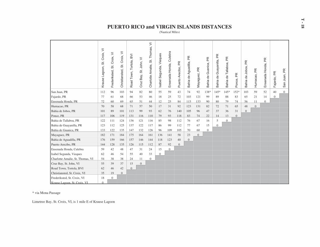
18PUERTO RICO and VIRGIN ISLANDS DISTANCES(Nautical Miles)
Kra
use L
agoon, S
t. C
roix
, V
I
Fre
derikste
d, S
t. C
roix
, V
I
Christianste
d, S
t. C
roix
, V
I
Road T
ow
n, T
ort
ola
, B
VI
Cru
z B
ay, S
t. J
ohn, V
I
Charlotte A
malie
, S
t. T
hom
as, V
I
Isabel S
egunda, V
ieques
Ensenada H
onda, C
ule
bra
Puert
o A
recib
o, P
R
Bahia
de A
guadill
a, P
R
Mayaguez, P
R
Bahia
de G
uanic
a, P
R
Bahia
de G
uayanill
a, P
R
Bahia
de T
alla
boa, P
R
Ponce, P
R
Bahia
de J
obos, P
R
Hum
acao, P
R
Ensenada H
onda, P
R
Faja
rdo, P
R
San J
uan, P
R
San Juan, PR 112 96 103 94 82 80 55 59 43 74 92 138* 145* 145* 152* 103 59 52 40 0
Fajardo, PR 77 61 68 66 53 46 18 25 72 103 121 99 89 88 83 65 21 14 0
Ensenada Honda, PR 72 60 69 65 51 44 12 25 84 115 133 90 80 79 74 56 11 0
Humacao, PR 70 58 68 71 57 50 17 31 92 123 131 82 72 71 65 48 0
Bahia de Jobos, PR 101 89 101 113 99 93 62 76 140 105 96 47 37 36 31 0
Ponce, PR 117 106 119 131 116 110 79 93 118 83 74 22 14 13 0
Bahia de Tallaboa, PR 122 111 124 136 121 116 85 98 112 76 67 16 5 0
Bahia de Guayanilla, PR 123 112 125 137 122 117 86 99 112 77 67 15 0
Bahia de Guanica, PR 133 122 135 147 132 126 96 109 105 70 60 0
Mayaguez, PR 182 171 184 175 164 161 136 141 58 23 0
Bahia de Aguadilla, PR 176 159 166 157 146 144 118 123 40 0
Puerto Arecibo, PR 144 128 135 126 115 112 87 92 0
Ensenada Honda, Culebra 59 42 48 47 31 24 15 0
Isabel Segunda, Vieques 62 46 54 55 40 33 0
Charlotte Amalie, St. Thomas, VI 54 38 38 24 11 0
Cruz Bay, St. John, VI 55 39 37 15 0
Road Town, Tortola, BVI 62 46 42 0
Christiansted, St. Croix, VI 35 19 0
Frederiksted, St. Croix, VI 18 0
Krause Lagoon, St. Croix, VI 0
* via Mona Passage
Limetree Bay, St. Croix, VI, is 1 mile E of Krause Lagoon

Distances on the Mississippi River System
(1) Distances in this section are the mileages (in stat-ute miles) from the mouth of a river (or other designatedpoint) taken from charts, maps, and publications of theU.S. Army Corps of Engineers. Distances between anytwo points on the same waterway may be obtained bytaking the difference of the indicated mileages. Dis-tances between places on different waterways can be de-termined by taking distances to and from a common ref-erence point.
(2) At Head of Passes three of the Mississippi River'simportant passes come together: South Pass, SouthwestPass and Pass a Loutre. This point of confluence is atHead of Passes East Jetty Light (29°09.1'N.,89°15.0'W.). From this point distances on the Missis-sippi River are measured in statute miles “above Head ofPasses”, abbreviated AHP, to its confluence with theOhio River.
(3) The reach of the Mississippi River from the Headof Passes to Baton Rouge is charted by NOAA's Na-tional Ocean Service (NOS). (See the appendix for in-formation relating to procurement of NOS charts andpublications.) The reach from the Head of Passes to theconfluence with the Ohio River is charted by the U.S.Army Corps of Engineers in “Flood Control and Navi-gation Maps of the Mississippi River” (www.mvd.usace.army.mil/reegis/navbook/main2.htm). Mileagesindicated in Flood Control and Navigation Maps of theMississippi River are in statute miles AHP and are solisted following.
(4) The following segment of the Mississippi Riveris from Head of Passes to its junction with the mouth ofthe Ohio River.
Head of Passes . . . . . . . . . . . . . . . . . . . . . . . . . . . . . 0Buras, LA . . . . . . . . . . . . . . . . . . . . . . . . . . . . . . . . . 25Port Sulphur, LA . . . . . . . . . . . . . . . . . . . . . . . . . . . 39Algiers Alternate Route (entrance to Algiers Lock) 88Inner Harbor Navigation Canal (Industrial Canal). . 93New Orleans (Canal Street) . . . . . . . . . . . . . . . . . . . 95Harvey Canal (lock entrance). . . . . . . . . . . . . . . . . . 98Donaldson, LA . . . . . . . . . . . . . . . . . . . . . . . . . . . . . 175Plaquemine, LA . . . . . . . . . . . . . . . . . . . . . . . . . . . . 209Baton Rouge, LA (IS 10 bridge)(add 64 miles
to Morgan City by Intracoastal waterway viaPort Allen Lock) . . . . . . . . . . . . . . . . . . . . . . . . . . 229
Red River mouth, LA (Old River) . . . . . . . . . . . . . . 304Natchez, MS (US84 bridge) . . . . . . . . . . . . . . . . . . . 363Vicksburg, MS . . . . . . . . . . . . . . . . . . . . . . . . . . . . . 437Greenville, MS (Warfield Pt. Lt).. . . . . . . . . . . . . . . 537Helena, AR . . . . . . . . . . . . . . . . . . . . . . . . . . . . . . . . 663Memphis, TN (IS 55 bridge) . . . . . . . . . . . . . . . . . . 734Ohio River mouth (Cairo, IL is 2 miles up the
Ohio River.). . . . . . . . . . . . . . . . . . . . . . . . . . . . . . 954
(5) The following segment of the Mississippi Riveris from its junction with the mouth of the Ohio Rivernortherly. The Upper River is charted by the U.S. ArmyCorps of Engineers in “Upper Mississippi River Navi-gation Charts” (www.mvr.usace.army.mil/NavCharts/UMRNavCharts.asp). The following mileages are instatute miles AHP.
Mississippi River and Ohio River junction . . . . . . . 954Commerce, MO . . . . . . . . . . . . . . . . . . . . . . . . . . . . 994Cape Girardeau, MO . . . . . . . . . . . . . . . . . . . . . . . . 1,006Grand Tower, IL . . . . . . . . . . . . . . . . . . . . . . . . . . . . 1,034St. Louis, MO . . . . . . . . . . . . . . . . . . . . . . . . . . . . . . 1,134Lock No. 27 . . . . . . . . . . . . . . . . . . . . . . . . . . . . . . . 1,139Dam No. 27 . . . . . . . . . . . . . . . . . . . . . . . . . . . . . . . 1,144Missouri River mouth. . . . . . . . . . . . . . . . . . . . . . . . 1,149Alton, IL (Lock and Dam No. 26) . . . . . . . . . . . . . . 1,157Illinois River mouth (Grafton, IL) . . . . . . . . . . . . . . 1,172Lock and Dam No. 25 . . . . . . . . . . . . . . . . . . . . . . . 1,195Lock and Dam No. 24 . . . . . . . . . . . . . . . . . . . . . . . 1,227Lock and Dam No. 22 . . . . . . . . . . . . . . . . . . . . . . . 1,255Hannibal, MO. . . . . . . . . . . . . . . . . . . . . . . . . . . . . . 1,264Quincy, IL (Lock and Dam No. 21) . . . . . . . . . . . . . 1,279La Grange, MO. . . . . . . . . . . . . . . . . . . . . . . . . . . . . 1,290Lock and Dam No. 20 . . . . . . . . . . . . . . . . . . . . . . . 1,297Keokuk, IA (Lock and Dam No. 19) . . . . . . . . . . . . 1,318Fort Madison, IA . . . . . . . . . . . . . . . . . . . . . . . . . . . 1,338Burlington, IA . . . . . . . . . . . . . . . . . . . . . . . . . . . . . 1,357Lock and Dam No. 18 . . . . . . . . . . . . . . . . . . . . . . . 1,364Lock and Dam No. 17 . . . . . . . . . . . . . . . . . . . . . . . 1,391Lock and Dam No. 16 . . . . . . . . . . . . . . . . . . . . . . . 1,411Davenport, IA (Lock and Sam No. 15) . . . . . . . . . . 1,437Lock and Dam No 14 . . . . . . . . . . . . . . . . . . . . . . . . 1,447Clinton, IA . . . . . . . . . . . . . . . . . . . . . . . . . . . . . . . . 1,473Lock and Dam No. 13 . . . . . . . . . . . . . . . . . . . . . . . 1,477Lock and Dam No. 12 . . . . . . . . . . . . . . . . . . . . . . . 1,511Dubuque, IA . . . . . . . . . . . . . . . . . . . . . . . . . . . . . . . 1,534Lock and Dam No. 11 . . . . . . . . . . . . . . . . . . . . . . . 1,537Lock and Dam No. 10 . . . . . . . . . . . . . . . . . . . . . . . 1,569Prairie du Chien, WI. . . . . . . . . . . . . . . . . . . . . . . . . 1,589Lock and Dam No. 9 . . . . . . . . . . . . . . . . . . . . . . . . 1,602Lock and Dam No. 8 . . . . . . . . . . . . . . . . . . . . . . . . 1,633La Crosse, WI. . . . . . . . . . . . . . . . . . . . . . . . . . . . . . 1,652Lock and Dam No.7 . . . . . . . . . . . . . . . . . . . . . . . . . 1,656Lock and Dam No.6 . . . . . . . . . . . . . . . . . . . . . . . . . 1,668Winona, MN . . . . . . . . . . . . . . . . . . . . . . . . . . . . . . . 1,680Lock and Dam No. 5A . . . . . . . . . . . . . . . . . . . . . . . 1,682Lock and Dam No. 5 . . . . . . . . . . . . . . . . . . . . . . . . 1,692Lock and Dam No. 4 . . . . . . . . . . . . . . . . . . . . . . . . 1,702Lock and Dam No. 3 . . . . . . . . . . . . . . . . . . . . . . . . 1,751Lock and Dam No. 2 . . . . . . . . . . . . . . . . . . . . . . . . 1,769St. Paul, MN . . . . . . . . . . . . . . . . . . . . . . . . . . . . . . . 1,793Lock and Dam No. 1 . . . . . . . . . . . . . . . . . . . . . . . . 1,802Minneapolis, MN . . . . . . . . . . . . . . . . . . . . . . . . . . . 1,807
T - 19

Ohio River(6) The Ohio River is charted by the U.S. Army
Corps of Engineers in “Ohio River Navigation Charts”in three volumes. Distances are in statute miles. Thefollowing locations appear in “Ohio River NavigationCharts, Louisville District” (www.lrl.usace.army.mil/optm/).
Ohio River mouth (junction with the Mississippi River). . . . . . . . . . . . . . . . . . . . . . . . . . . . . . . . . . . . . . . . . 0
Cairo, IL . . . . . . . . . . . . . . . . . . . . . . . . . . . . . . . . . . 2Dam 53 . . . . . . . . . . . . . . . . . . . . . . . . . . . . . . . . . . . 18Dam 52 . . . . . . . . . . . . . . . . . . . . . . . . . . . . . . . . . . . 42Tennessee River mouth (Paducah, KY) . . . . . . . . . . 46Cumberland River mouth . . . . . . . . . . . . . . . . . . . . . 58Smithland Lock and Dam. . . . . . . . . . . . . . . . . . . . . 62Wabash River mouth . . . . . . . . . . . . . . . . . . . . . . . . 133Evansville, IN . . . . . . . . . . . . . . . . . . . . . . . . . . . . . . 187Newburg Lock and Dam. . . . . . . . . . . . . . . . . . . . . . 205Owensboro, KY . . . . . . . . . . . . . . . . . . . . . . . . . . . . 225Cannelton Lock and Dam. . . . . . . . . . . . . . . . . . . . . 260McAlpine Lock and Dam . . . . . . . . . . . . . . . . . . . . . 374Louisville, KY (IS 65 bridge). . . . . . . . . . . . . . . . . . 378Madison, IN . . . . . . . . . . . . . . . . . . . . . . . . . . . . . . . 423Markland Lock and Dam . . . . . . . . . . . . . . . . . . . . . 449Cincinnati, OH . . . . . . . . . . . . . . . . . . . . . . . . . . . . . 509Captain Anthony Meldahl Dam . . . . . . . . . . . . . . . . 545
(7) The following locations appear in “Ohio RiverNavigation Charts, Huntington District.”
Portsmouth, OH . . . . . . . . . . . . . . . . . . . . . . . . . . . . 626Greenup Dam . . . . . . . . . . . . . . . . . . . . . . . . . . . . . . 640Ironton, OH . . . . . . . . . . . . . . . . . . . . . . . . . . . . . . . 655Huntington, WV . . . . . . . . . . . . . . . . . . . . . . . . . . . . 673Gallipolis Dam . . . . . . . . . . . . . . . . . . . . . . . . . . . . . 702Gallipolis, OH . . . . . . . . . . . . . . . . . . . . . . . . . . . . . 711Belleville Dam . . . . . . . . . . . . . . . . . . . . . . . . . . . . . 777Parkersburg, WV . . . . . . . . . . . . . . . . . . . . . . . . . . . 797Marietta, OH. . . . . . . . . . . . . . . . . . . . . . . . . . . . . . . 809Willow Island Dam. . . . . . . . . . . . . . . . . . . . . . . . . . 820
(8) The following locations appear in “Ohio RiverNavigation Charts, Pittsburgh District.”
Hannibal Lock and Dam . . . . . . . . . . . . . . . . . . . . . 855Wheeling, WV . . . . . . . . . . . . . . . . . . . . . . . . . . . . . 894Pike Island Lock and Dam . . . . . . . . . . . . . . . . . . . . 897Steubenville, OH . . . . . . . . . . . . . . . . . . . . . . . . . . . 913New Cumberland Lock and Dam . . . . . . . . . . . . . . . 927East Liverpool, OH. . . . . . . . . . . . . . . . . . . . . . . . . . 938Montgomery Lock and Dam . . . . . . . . . . . . . . . . . . 950Dashields Lock and Dam . . . . . . . . . . . . . . . . . . . . . 968Emsworth Lock and Dam. . . . . . . . . . . . . . . . . . . . . 975Pittsburgh, PA (Point Bridge) . . . . . . . . . . . . . . . . . . 981
Tennessee River(9) The Tennessee River is charted by the U.S.
Army Corps of Engineers in “Tennessee River Naviga-
tion Charts, Nashville District.” (See appendix for pro-curement information.) Distances are in statute miles.
Tennessee River mouth (junction with the OhioRiver) . . . . . . . . . . . . . . . . . . . . . . . . . . . . . . . . . . . 0
Paducah, KY. . . . . . . . . . . . . . . . . . . . . . . . . . . . . . . 0Kentucky Lock and Dam . . . . . . . . . . . . . . . . . . . . . 22New Johnsonville, TN . . . . . . . . . . . . . . . . . . . . . . . 100Perryville, TN. . . . . . . . . . . . . . . . . . . . . . . . . . . . . . 135Saltillo . . . . . . . . . . . . . . . . . . . . . . . . . . . . . . . . . . . 172Cerro Gordo . . . . . . . . . . . . . . . . . . . . . . . . . . . . . . . 178Savannah. . . . . . . . . . . . . . . . . . . . . . . . . . . . . . . . . . 190Pickwick Landing Lock and Dam . . . . . . . . . . . . . . 207Waterloo, AL . . . . . . . . . . . . . . . . . . . . . . . . . . . . . . 227Sheffield, AL . . . . . . . . . . . . . . . . . . . . . . . . . . . . . . 254Wilson Lock and Dam (Florence, AL). . . . . . . . . . . 260General Joe Wheeler Lock and Dam . . . . . . . . . . . . 275Decatur, AL . . . . . . . . . . . . . . . . . . . . . . . . . . . . . . . 304Guntersville Lock and Dam . . . . . . . . . . . . . . . . . . . 349Bridgeport. . . . . . . . . . . . . . . . . . . . . . . . . . . . . . . . . 414South Pittsburgh . . . . . . . . . . . . . . . . . . . . . . . . . . . . 418Nickajack Lock and Dan . . . . . . . . . . . . . . . . . . . . . 425Chattanooga, TN . . . . . . . . . . . . . . . . . . . . . . . . . . . 464Chickamauga Lock and Dam . . . . . . . . . . . . . . . . . . 471Watts Bar Lock and Dam . . . . . . . . . . . . . . . . . . . . . 530Clinch River mouth . . . . . . . . . . . . . . . . . . . . . . . . . 568Loudon, TN . . . . . . . . . . . . . . . . . . . . . . . . . . . . . . . 592Fort Loudon Lock and Dam . . . . . . . . . . . . . . . . . . . 602Knoxville, TN (Gay Street bridge). . . . . . . . . . . . . . 648
Missouri River(10) The Missouri River is charted by the U.S. Army
Corps of Engineers in “Missouri River NavigationCharts” in two volumes. (See appendix for procure-ment information.) Distances are in statute miles. Thefollowing locations appear in “Missouri River Naviga-tion Charts, Kansas City District.”
Missouri River mouth (junction with the MississippiRiver) . . . . . . . . . . . . . . . . . . . . . . . . . . . . . . . . . . . 0
St. Charles, MO . . . . . . . . . . . . . . . . . . . . . . . . . . . . 28Washington, MO. . . . . . . . . . . . . . . . . . . . . . . . . . . . 67Hermann, MO. . . . . . . . . . . . . . . . . . . . . . . . . . . . . . 98Mouth of Gasconade River. . . . . . . . . . . . . . . . . . . . 104Gasconade, MO . . . . . . . . . . . . . . . . . . . . . . . . . . . . 105Mouth of Auxvass River. . . . . . . . . . . . . . . . . . . . . . 120Mouth of Middle River. . . . . . . . . . . . . . . . . . . . . . . 125Mouth of Osage River . . . . . . . . . . . . . . . . . . . . . . . 130Jefferson City, MO . . . . . . . . . . . . . . . . . . . . . . . . . . 143Boonville, MO . . . . . . . . . . . . . . . . . . . . . . . . . . . . . 197Mouth of Lamine River . . . . . . . . . . . . . . . . . . . . . . 202Glasgow, MO . . . . . . . . . . . . . . . . . . . . . . . . . . . . . . 226Mouth of Charitan River. . . . . . . . . . . . . . . . . . . . . . 239Mouth of Grand River . . . . . . . . . . . . . . . . . . . . . . . 250Miami, MO. . . . . . . . . . . . . . . . . . . . . . . . . . . . . . . . 263Waverly, MO. . . . . . . . . . . . . . . . . . . . . . . . . . . . . . . 294Lexington, MO . . . . . . . . . . . . . . . . . . . . . . . . . . . . . 317Napoleon, MO . . . . . . . . . . . . . . . . . . . . . . . . . . . . . 329Kansas City, MO . . . . . . . . . . . . . . . . . . . . . . . . . . . 363Mouth of Kansas River. . . . . . . . . . . . . . . . . . . . . . . 367
T - 20

(11) The following locations appear in “MissouriRiver Navigation Charts, Omaha District.”
Kansas City, MO . . . . . . . . . . . . . . . . . . . . . . . . . . . 363Mouth of Kansas River. . . . . . . . . . . . . . . . . . . . . . . 367Leavenworth, KS . . . . . . . . . . . . . . . . . . . . . . . . . . . 396St. Joseph, MO . . . . . . . . . . . . . . . . . . . . . . . . . . . . . 448Mouth of Big Nemaha River . . . . . . . . . . . . . . . . . . 495Rulo, NE. . . . . . . . . . . . . . . . . . . . . . . . . . . . . . . . . . 498Mouth of Tarkio River . . . . . . . . . . . . . . . . . . . . . . . 507Mouth of Nishnabotna River . . . . . . . . . . . . . . . . . . 542Nebraska City, NE . . . . . . . . . . . . . . . . . . . . . . . . . . 563Plattsmouth, NE . . . . . . . . . . . . . . . . . . . . . . . . . . . . 591Omaha, NE . . . . . . . . . . . . . . . . . . . . . . . . . . . . . . . . 615Council Bluffs, IA . . . . . . . . . . . . . . . . . . . . . . . . . . 617Dakota City, NE . . . . . . . . . . . . . . . . . . . . . . . . . . . . 725Sioux City, IA. . . . . . . . . . . . . . . . . . . . . . . . . . . . . . 732Ponca, NE. . . . . . . . . . . . . . . . . . . . . . . . . . . . . . . . . 753
Illinois Waterway(12) The Illinois Waterway is charted by the U.S.
Army Corps of Engineers in “Charts of the Illinois Wa-terway from Mississippi River at Grafton, IL to LakeMichigan at Chicago.” Distances therein and followingare in statute miles.
Illinois River
Illinois River mouth (junction of the MississippiRiver at Grafton, IL) . . . . . . . . . . . . . . . . . . . . . . . 0
Hardin, IL . . . . . . . . . . . . . . . . . . . . . . . . . . . . . . . . . 21.0Florence, IL . . . . . . . . . . . . . . . . . . . . . . . . . . . . . . . 55Naples, IL . . . . . . . . . . . . . . . . . . . . . . . . . . . . . . . . . 65La Grange Lock . . . . . . . . . . . . . . . . . . . . . . . . . . . . 80Beardstown, IL . . . . . . . . . . . . . . . . . . . . . . . . . . . . . 89Peoria Lock. . . . . . . . . . . . . . . . . . . . . . . . . . . . . . . . 158Chillicothe, IL . . . . . . . . . . . . . . . . . . . . . . . . . . . . . 180Hennepin, IL. . . . . . . . . . . . . . . . . . . . . . . . . . . . . . . 207Illinois and Mississippi Canal . . . . . . . . . . . . . . . . . 210Peru, IL. . . . . . . . . . . . . . . . . . . . . . . . . . . . . . . . . . . 222Ottawa, IL. . . . . . . . . . . . . . . . . . . . . . . . . . . . . . . . . 239Marseille Lock . . . . . . . . . . . . . . . . . . . . . . . . . . . . . 244Dresden Island Lock. . . . . . . . . . . . . . . . . . . . . . . . . 271
Des Plaines RiverJoliet, IL . . . . . . . . . . . . . . . . . . . . . . . . . . . . . . . . . . 288
Chicago Sanitary and Ship CanalLockport, IL . . . . . . . . . . . . . . . . . . . . . . . . . . . . . . . 293
Chicago RiverChicago, IL (41°43.8'N., 87°31.9'W.) . . . . . . . . . . . 333
T - 21

T -
22GREAT LAKES DISTANCES(Statute Miles)
Mon
trea
l, Q
uebe
c
Ogd
ensb
urg,
NY
Kin
gsto
n, O
ntar
io
Tor
onto
, Ont
ario
Osw
ego,
NY
Roc
hest
er, N
Y
Port
Col
burn
e, O
ntar
io
Buf
falo
, NY
Eri
e, P
A
Con
neau
t, O
H
Ash
tabu
la, O
H
Fair
port
, OH
Cle
vela
nd, O
H
Lor
ain,
OH
Tol
edo,
OH
Det
roit
, MI
Port
Hur
on, M
I
Mid
land
, Ont
ario
Col
ling
woo
d, O
ntar
io
God
eric
h, O
ntar
io
Bay
Cit
y, M
I
Alp
ena,
MI
Lud
ingt
on, M
I
Mus
kego
n, M
I
Gar
y, I
N
Chi
cago
, IL
Mil
wau
kee,
WI
Gre
en B
ay, W
I
Esc
anab
a, M
I
Sual
t Ste
. Mar
ie, M
I
Mar
quet
te, M
I
Hou
ghto
n, M
I
Ash
land
, WI
Dul
uth,
MN
Tw
o H
arbo
rs, M
N
Thu
nder
Bay
, Ont
ario
Thunder Bay, Ontario 1217 1096 1034 903 1016 965 848 864 795 768 754 729 711 694 658 604 542 539 531 506 505 410 536 587 699 686 621 560 492 273 171 116 164 195 172 -
Two Harbors, MN 1315 1194 1132 1001 1114 1063 946 963 893 866 852 828 809 792 756 702 640 638 630 604 603 508 634 685 797 785 720 659 590 371 239 157 71 26 -
Duluth, MN 1339 1218 1156 1025 1138 1087 970 986 917 890 876 851 833 816 781 726 664 661 653 628 627 532 657 709 820 808 743 682 614 394 261 179 96 -
Ashland, WI 1293 1172 1110 979 1092 1041 924 941 871 844 830 806 788 771 734 680 618 616 606 583 581 486 612 663 775 763 698 637 568 349 213 131 -
Houghton, MI 1165 1044 982 851 964 913 796 813 743 716 702 678 659 643 606 552 490 488 480 455 453 358 484 535 647 635 570 509 440 221 84 -
Marquette, MI 1104 983 921 790 903 852 735 751 682 655 641 616 598 581 545 491 429 426 418 393 391 297 422 474 585 573 508 447 378 159 -
Sualt Ste. Marie, MI (a) 944 823 761 630 743 692 575 592 522 495 481 457 438 422 385 331 269 267 259 234 232 137 263 314 426 414 349 288 219 -
Escanaba, MI 1051 930 868 737 850 799 682 699 629 602 588 564 545 526 492 438 376 384 376 340 339 244 130 181 288 274 201 101 -
Gren Bay, WI 1120 999 937 806 919 868 751 767 696 671 657 632 614 597 561 507 445 452 444 409 407 313 123 171 272 255 180 -
Milwaukee, WI 1181 1060 998 867 980 929 812 828 759 732 718 693 675 658 622 568 506 513 505 470 468 374 97 80 103 85 -
Chicago, IL 1246 1125 1063 932 1045 994 877 893 824 797 783 758 740 723 688 633 571 578 570 535 534 439 156 114 25 -
Gary, IN 1258 1137 1075 944 1057 1006 889 905 836 809 795 770 752 735 699 645 583 590 582 547 546 451 167 121 -
Muskegon, MI 1146 1025 963 832 945 894 777 794 724 697 683 659 640 623 587 533 471 479 471 435 434 339 56 -
LudIngton, MI 1095 974 912 781 894 843 726 742 673 646 632 607 589 572 536 482 420 427 419 384 383 288 -
Alpena, MI 832 711 649 518 631 580 463 479 410 383 369 344 326 309 273 219 157 193 185 124 116 -
Bay City, MI 837 716 654 523 638 585 466 484 415 388 374 349 331 314 278 224 162 265 257 137 -
Goderich, Ontario 740 619 557 426 539 488 371 387 318 291 277 252 234 217 181 127 65 211 207 -
EXPLANATION
Measurements are by the shortest markedor safe direct courses, starting (unlessotherwise noted) from the main entrancebetween pierheads of breakwaters or piers,or from the principal landings of openroadsteads.
Where landings are appreciably remotefrom protected entrances, the distance fromthe main entrance to the landing may beascertained from the harbor description orfrom nautical charts.
Points in this table are arraigned in theorder of their location on the Great Lakesin the following sequence (top to bottom):Lake Superior, Lake Michigan, LakeHuron, Lake Erie, and Lake Ontario- St.Lawrence River.
Collingwood, Ontario 933 812 750 619 732 681 564 580 511 484 470 446 427 410 374 320 258 55 -
Midland, Ontario 941 820 758 627 740 689 572 588 519 492 478 453 435 418 382 326 266 -
Port Huron, MI (b) 675 554 492 361 474 423 306 322 253 226 213 188 170 152 116 62 -
Detroit, MI (c) 613 492 430 299 412 361 244 261 191 164 150 126 108 91 54 -
Toledo, OH (river mouth) 606 485 423 292 405 354 237 254 185 157 144 119 96 72 -
Lorain, OH 549 428 366 235 348 297 180 197 124 95 80 53 28 -
Cleveland, OH (main entrance) 529 408 346 215 326 277 160 176 102 73 59 33 -
Fairport, OH 499 378 316 185 298 247 130 146 73 44 30 -
Ashtabula, OH 473 352 290 159 272 221 104 119 45 15 -
Conneaut, OH 461 340 278 147 260 209 92 107 33 -
Erie, PA 434 313 251 120 233 182 65 78 -
Buffalo, NY (north entrance) 391 270 208 77 190 139 22 -
Port Colburne, Ontario 369 248 186 55 168 117 - (a) From abreast east end of U.S. center pier(b) From foot of Grand RiverAve.(c) From Woodward Ave.(d) From St. Lambert Dock
Rochester, NY 271 149 89 95 59 -
Oswego, NY 232 108 55 145 -
Toronto, Ontario 342 223 161 -
Kingston, Ontario 185 63 -
Ogdensburg, NY 123 -
Montreal, Quebec (d) -

T -
23
DISTANCES BETWEEN POINTS ON LAKE ONTARIO AND ST. LAWRENCE RIVER(Statute Miles)
Queb
ec C
ity,
Queb
ec
Montr
eal,
Queb
ec
Cote
St.
Cat
h.
Lock
, Q
ueb
ec
Bea
uhar
nois
Lock
, Q
ueb
ec
Co
lqu
ho
un
Isl
and
, O
nta
rio
Snel
l L
ock
, N
Y
Eis
enhow
er L
ock
, N
Y
Iro
qu
ios
Lo
ck,
On
tari
o
Ogden
sburg
, N
Y
Bro
ckvil
le,
Onta
rio
Ale
xan
dri
a B
ay,
NY
Th
ou
san
d I
slan
d P
ark
, N
Y
Cla
yto
n,
NY
Gan
ano
qu
e, O
nta
rio
Kin
gst
on
, O
nta
rio
Pic
ton
, O
nta
rio
Des
ero
nto
, O
nta
rio
Bel
levil
le,
Onta
rio
Tre
nto
n,
Onta
rio
Co
bo
urg
, O
nta
rio
Port
Ho
pe,
On
tari
o
Toro
nto
, O
nta
rio
Ham
ilto
n,
Onta
rio
Port
Wel
ler,
NY
Lew
isto
n,
NY
Nia
gar
a-on-t
he-
Lak
e,
Olc
ott
, N
Y
Roch
este
r, N
Y
Sodus
Bay
, N
Y
Lit
tle
So
du
s B
ay,
NY
Osw
ego,
NY
Sac
ket
ts H
arbor,
NY
Cap
e V
ince
nt,
NY
Port
Co
lbo
rne,
On
tari
o
Port
Hu
ron
, M
I
Old
Mac
kin
ac P
oin
t, M
I
OLD MACKINAC POINT, MI (a) 1084 922 914 892 848 841 837 812 799 787 766 760 755 758 739 726 713 69 688 653 648 608 610 580 598 592 608 670 698 712 721 745 740 553 247 -
PORT HURON, MI (b) 837 675 667 645 601 594 590 565 552 540 519 513 508 511 492 479 466 45 441 406 401 361 363 333 351 345 361 423 451 465 474 498 493 306 -
PORT COLBORNE, ONTARIO 531 369 361 339 295 288 284 259 246 234 213 207 202 205 186 173 160 14 135 100 95 55 57 27 45 39 55 117 145 159 168 192 187 -
Cape Vincent, NY 344 183 175 153 109 102 98 73 60 48 27 20 16 19 24 45 51 67 78 101 106 160 186 160 160 154 134 89 69 59 49 26 -
Sacketts Harbor, NY 370 209 201 179 135 128 124 99 86 74 53 46 42 45 36 56 61 78 88 106 112 165 191 165 164 158 138 88 54 52 41 -
Oswego, NY 391 232 224 202 158 151 147 122 108 97 76 69 65 68 55 66 71 88 82 91 96 145 166 141 139 133 113 59 29 15 -
Little Sodus Bay, NY 401 241 233 211 167 160 156 131 118 106 85 78 74 77 64 73 78 88 79 85 90 136 157 131 130 124 104 48 18 -
Sodus Bay, NY 411 251 243 221 177 170 166 141 128 116 95 88 84 87 72 80 86 83 74 77 81 124 145 118 118 112 92 35 -
Rochester, NY (Charlotte) 432 271 263 241 197 190 186 161 149 136 115 108 104 107 90 98 89 73 64 57 60 96 117 89 89 83 63 -
Olcott, NY 478 316 308 286 242 235 231 206 193 181 160 153 149 152 134 121 109 92 83 51 47 38 55 28 28 22 -
Niagara-on-the-Lake, Ontario 500 336 328 306 262 255 251 226 213 201 180 173 169 172 154 141 128 11 102 66 63 30 39 11 6 -
Lewiston, NY 506 342 334 312 268 261 257 232 219 207 186 179 175 178 160 147 134 11 108 72 69 36 45 17 -
Port Weller, NY 504 342 334 312 268 261 257 232 219 207 186 179 175 178 159 146 133 11 107 72 68 28 30 -
Hamilton, Ontario 530 367 359 337 293 286 282 257 244 232 211 205 200 204 185 169 156 14 131 94 88 30 -
Toronto, Ontario (West Entrance) 506 342 334 312 268 261 257 232 219 207 186 180 175 179 160 142 129 11 103 65 60 -
Port Hope, Ontaro 449 289 281 259 215 208 204 179 166 154 132 126 121 125 106 85 72 56 47 7 -
Cobourg, Ontario 444 283 275 253 209 202 196 173 160 148 127 120 116 120 101 79 67 50 41 -
Trenton, Ontario 417 255 247 225 181 174 170 145 132 120 101 94 90 89 71 40 28 11 -
Belleville, Ontario 406 244 236 214 170 163 159 134 121 109 90 84 80 78 60 29 17 -
Deseronto, Ontario 390 228 220 198 154 147 143 118 105 93 74 68 63 62 44 13 -
Picton, Ontario 383 222 214 192 148 141 137 112 99 87 68 62 57 56 37 -
Kingston, Ontario 346 185 177 155 111 104 100 75 62 50 32 25 21 19 -
Gananoque, Ontario 327 167 159 137 93 86 82 57 44 32 18 11 10 -
Clayton, NY 327 167 159 137 93 86 82 57 44 32 11 4 -
Thousand Island Park, NY 326 164 156 134 90 83 79 54 41 29 8 -
Alexandria Bay, NY 317 156 148 127 83 76 72 46 33 22 -
Brockville, Ontario 295 135 127 105 61 54 50 25 12 -
Ogdensburg, NY 283 123 115 93 49 42 38 13 -
Iroquois Lock, Ontario 270 110 102 80 36 29 25 -
Eisenhower Lock, NY 245 85 77 55 11 4 -
Snell Lock, NY 241 81 73 51 7 - (a) From sailing course point north
of Old Mackinac Point
(b) From foot of Grand River Ave. to
Toronto west entrance.
Colquhoun, Island, Ontario 233 74 66 44 -
Beauharnois Lock, Quebec 190 30 22 -
Cote St. Catherine Lock, Quebec 169 8 -
Montreal, St. Lambert Lock, Quebec 160 -
Quebec City, Quebec -

T -
24
DISTANCES BETWEEN POINTS ON LAKE ERIE AND THE ST. CLAIR, DETROIT AND NIAGARA RIVERS(Statute Miles)
Kin
gsvi
lle,
Ont
ario
Ron
deau
, Ont
ario
Por
t Sta
nley
, Ont
ario
Por
t Bur
wel
l, O
ntar
io
Por
t Dov
er, O
ntar
io
Por
t Mai
tlan
d, O
ntar
io
Nia
gara
Fal
ls, N
Y
Ton
awan
da, N
Y
Buf
falo
, NY
Dun
kirk
, NY
Eri
e, P
A
Con
neau
t, O
H
Ash
tabu
la, O
H
Fai
rpor
t, O
H
Cle
vela
nd, O
H
Lor
ain,
OH
Ver
mil
ion,
OH
Hur
on, O
H
San
dusk
y, O
H
Put
-in-
Bay
, OH
Por
t Cli
nton
, OH
Tol
edo,
OH
Mon
roe,
MI
De t
roit
Riv
e r L
ight
, MI
Am
hers
tbur
g, O
nta r
io
Tre
nton
, MI
Wyo
ndot
te, M
I
Det
roit
, MI
Cha
tham
, Ont
ario
Mou
nt C
lem
ons,
MI
St.
Cla
ir F
lats
, MI/
Ont
.
Alg
ona c
, MI
Ma r
ine
Cit
y, M
I
St.
Cla
ir, M
I
Por
t Hur
on, M
I
Por
t Col
born
e , O
nta r
io
Old
Mac
kina
c P
oint
, MI
OLD MACKINAC POINT, MI (a) 358 414 459 475 527 538 588 580 569 539 500 473 460 435 417 399 391 387 380 363 369 363 348 334 326 324 320 309 322 296 286 274 266 259 247 553 -
PORT COLBORNE, ONTARIO 201 146 109 89 52 18 41 33 22 25 65 92 104 130 160 180 190 198 204 204 213 237 227 219 227 229 234 244 292 278 267 281 287 294 306 -
PORT HURON, MI (b) 111 167 212 228 280 291 341 333 322 292 253 226 213 188 170 152 144 140 133 116 122 116 101 87 79 77 73 62 75 49 39 27 19 12 -
St. Clair, MI 99 155 200 216 268 279 330 322 311 281 241 214 201 176 158 141 133 129 122 105 111 105 89 75 67 65 61 50 63 37 27 15 7 -
Marine City, MI 92 148 193 209 261 272 322 314 303 273 234 207 194 169 151 133 125 121 114 97 103 97 82 68 60 58 54 43 56 30 20 7 -
Algonac, MI 86 143 188 203 255 267 317 309 296 268 228 201 188 163 145 128 120 116 109 92 98 92 76 62 55 53 48 37 49 22 14 -
St. Clair Flats, MI/Ont. (c) 72 129 174 189 241 253 303 295 284 254 215 187 174 149 131 114 106 102 95 78 84 78 62 48 41 39 34 23 35 15 -
Mount Clemons, MI 83 140 185 200 252 264 314 306 295 265 226 199 185 161 142 125 117 113 106 89 95 89 73 59 53 50 45 35 49 -
Chatham, Ontario 97 154 199 214 265 278 328 320 309 279 239 212 198 174 156 139 130 127 120 102 108 102 87 73 66 63 59 48 -
Detroit, MI (Woodward Ave.) 49 106 151 166 217 230 280 272 261 231 191 164 150 126 108 91 82 79 72 54 60 54 39 25 18 15 11 -
Wyondotte, MI 39 96 141 156 208 220 270 262 251 221 182 154 141 116 98 81 73 69 62 45 51 45 29 15 8 5 -
Trenton, MI 34 91 136 151 203 215 265 257 246 216 177 149 136 111 93 76 68 64 57 40 46 40 24 10 13 -
Amherstburg, Ontario 31 88 133 148 200 212 262 254 243 213 173 146 133 108 90 73 64 61 54 36 42 36 21 7 -
Detroit River Light, MI 24 81 126 141 193 205 255 247 236 206 166 139 126 101 83 66 58 54 47 30 36 30 14 -
Monroe, MI (piers) 33 89 134 149 200 213 263 255 244 214 174 147 133 109 89 68 60 5 48 30 35 21 -
Toledo, OH (river mouth) 45 98 143 159 210 223 272 265 254 224 185 157 144 119 96 72 65 59 52 38 40 -
Port Clinton, OH 37 75 120 136 187 199 249 241 230 200 160 131 118 92 67 43 36 29 22 12 -
Put-in-Bay, OH 27 66 111 127 177 190 240 232 221 190 150 122 109 83 51 38 32 27 21 -
Sandusky, OH (wharves) 41 69 114 130 178 190 239 232 221 189 149 120 107 79 55 29 21 14 -
Huron, OH 47 68 111 124 172 184 233 226 215 183 142 113 99 72 47 20 11 -
Vermilion, OH 46 62 104 117 163 175 225 217 206 174 133 104 90 63 37 11 -
Lorain, OH 48 57 97 109 154 166 215 208 197 164 124 95 80 53 28 -
Cleveland, OH (main entrance) 65 53 85 93 134 146 194 187 176 143 102 73 59 33 -
Fairport, OH 83 48 62 66 104 116 165 157 146 114 73 44 30 -
Ashtabula, OH 108 63 56 47 79 90 138 130 119 86 45 15 -
Conneaut, OH 122 74 59 48 68 80 126 118 107 74 33 -
Erie, PA 149 98 70 53 47 54 98 89 78 45 -
Dunkirk, NY 188 134 98 78 50 28 55 48 37 -
Buffalo, NY 218 163 126 106 72 38 21 13 -
Tonawanda, NY 230 174 137 117 83 49 8 -
Niagara Falls, NY 237 182 145 125 90 57 - (a) From sailing point north of OldMackinac Point.(b) From foot of Grand RiverAvenue.(c) From south end of canal dike.
EXPLANATIONPoints in this table are arranged in geographicalsequence proceeding southward in St. Clair River andLake, and Detroit River, then eastward along the southshore of Lake Erie to Niagara River, and returningwestward along the north lake shore
Port Maitland, Ontario 187 132 95 75 37 -
Port Dover, Ontario 175 120 83 62 -
Port Burwell, Ontario 123 65 23 -
Port Stanley, Ontario 108 49 -
Rondeau, Ontario 63 -
Kingsville, Ontario -

T -
25
DISTANCES BETWEEN POINTS ON LAKE HURON AND ST. MARYS RIVER(Statute Miles)
Th
essa
lon
, O
nta
rio
Alg
om
a M
ills
, O
nta
rio
Go
re B
ay,
On
tari
o
Lit
tle
Cu
rren
t, O
nta
rio
Fre
nch
Riv
er,
On
tari
o
Key
Har
bo
r, O
nta
rio
By
ng
In
let,
On
tari
o
Par
ry S
ou
nd
, O
nta
rio
Dep
ot
Har
bo
r, O
nta
rio
Po
rt M
cNic
oll
, O
nta
rio
Mid
lan
d,
On
tari
o
Pen
etan
gu
ish
ene,
On
tari
o
Co
llin
gw
oo
d,
On
tari
o
Mea
ford
, O
nta
rio
Ow
en S
ou
nd
, O
nta
rio
Wia
rto
n,
On
tari
o
So
uth
amp
ton
, O
nta
rio
Kin
card
ine,
On
tari
o
Go
der
ich
, O
nta
rio
Po
rt S
anil
ac,
MI
Har
bo
r B
each
, M
I
Sag
inaw
, M
I
Bay
Cit
y,
MI
Eas
t T
awas
, M
I
Au
Sab
le,
MI
Alp
ena,
MI
Ro
ckp
ort
, M
I
Sto
nep
ort
, M
I
Ro
ger
s C
ity
, M
I
Ch
ebo
yg
an,
MI
Mac
kin
ac I
slan
d,
MI
St.
Ig
nac
e, M
I
Po
rt D
olo
mit
e, M
I
DeT
ou
r, M
I
Sau
lt S
te.
Mar
ie,
MI
Old
Mac
kin
ac P
oin
t, M
I
Po
rt H
uro
n,
MI
Port Huron, MI (a) *238 +238 +250 225 224 232 229 247 243 267 266 265 258 241 238 228 121 94 65 33 63 175 162 119 117 157 166 182 194 233 243 247 239 224 269 247 -
Old Mackinac Point, MI (b) 69 *101 *116 *143 *196 *205 *211 235 231 256 255 254 247 230 227 217 189 192 211 215 186 223 210 163 142 115 83 78 54 18 7 6 27 45 90 -
Sault Ste. Marie, MI (c) & 48 & 88 &108 &131 &184 &193 &201 &242 +238 268 267 266 259 242 239 229 207 213 234 238 208 246 232 185 165 137 107 96 84 84 84 90 68 45 -
DeTour, MI %24 %58 %76 %101 %154 %163 %171 201 198 224 222 221 214 197 194 185 162 168 189 193 164 201 187 140 120 92 61 51 40 39 39 44 23 -
Port Dolomite, MI +92 +90 +108 +135 197 199 198 218 215 243 241 238 233 220 219 207 176 183 203 218 190 219 206 163 143 113 76 70 47 31 26 28 -
St. Ignace, MI %68 *100 *115 *142 *195 *204 *209 234 231 256 254 252 246 229 227 217 191 194 214 216 187 224 210 163 143 115 83 82 55 20 8 -
Mackinac Island, MI %63 *95 *110 *137 *190 *199 *204 229 226 251 249 248 241 224 221 212 186 189 209 212 184 220 207 159 140 111 79 77 50 17 -
Cheboygan, MI %63 *92 *106 *133 *186 *195 *197 221 217 242 241 240 233 216 213 204 175 178 198 202 173 210 196 149 129 101 69 66 40 -
Rogers City, MI *63 +74 +87 +114 157 163 164 187 183 208 206 206 199 182 177 169 139 142 161 163 134 171 157 110 90 61 31 27 -
Stoneport, MI +75 +73 +92 +118 145 147 147 166 163 190 189 186 181 164 163 151 115 120 146 158 130 154 141 97 76 48 9 -
Rockport, MI *79 +79 +92 +119 136 143 143 166 162 187 186 185 178 161 158 148 112 113 132 134 106 142 129 82 62 31 -
Alpena, MI *107 +107 +120 +143 145 151 152 174 171 195 193 192 185 168 165 156 109 107 124 125 97 129 116 69 49 -
Au Sable, MI *135 +135 +148 158 160 163 166 183 180 204 202 201 189 177 174 165 98 85 93 86 58 83 69 21 -
East Tawas, MI *155 +155 +168 175 176 180 182 199 196 220 218 217 210 194 190 181 110 94 95 88 60 68 54 -
Bay City, MI *202 +202 +215 222 223 228 229 245 243 267 265 264 257 240 237 226 153 136 137 130 102 13 -
Saginaw, MI *216 +216 +228 235 237 242 242 258 256 280 278 278 271 254 250 241 167 149 151 144 115 -
Harbor Beach, MI *178 +178 +191 171 171 176 176 194 190 214 213 212 205 188 185 175 79 56 47 32 -
Port Sanilac, MI *207 +207 +219 197 196 201 201 219 215 239 238 237 230 213 210 200 97 70 47 -
Goderich, Ontario +195 +196 204 169 172 172 174 192 189 213 211 210 207 187 183 174 64 36 -
Kincardine, Ontario +173 +174 174 141 142 149 144 162 158 182 181 180 176 156 153 144 30 -
Southampton, Ontario +166 +166 155 122 123 130 125 143 140 163 162 161 157 137 134 125 -
Wiarton, Ontario (d) +188 158 142 110 88 79 81 74 71 76 74 73 53 36 29 -
Owen Sound, Ontario (d) +197 167 152 119 97 97 89 79 75 71 70 69 46 29 -
Meaford, Ontario (d) +200 169 153 121 96 96 86 71 68 55 53 52 24 -
Collingwood, Ontario (d) +217 186 171 138 108 107 97 80 76 57 55 54 -
Penetanguishene, Ontario +224 187 172 139 106 104 94 72 69 12 10 -
Midland, Ontario (d) +225 186 173 140 107 105 95 73 70 7 -
Port McNicoll, Ontario (d) +227 190 174 142 106 106 97 75 71 -
Depot Harbor, Ontario (d) 193 155 140 107 73 71 62 6 -
Parry Sound, Ontario (d) 197 159 143 111 77 75 65 - (a) From foot of Grand River Ave.
(b) From sailing course point north of Old Mackinac
Point.
(c) From abreast east end of U.S. center pier and (except
those marked by $) via Middle Neebish and DeTour;
distances downbound through West Neebish are 1 mile
less.
(d) Distances to Georgian Bay ports (except those
marked *, +, $, =) are via the bay entrance from Lake
Huronand St. Marys River points and via Little Current
from North Channel points.
* Via False Detour and North Channels.
+ Via Mississaqi Straight and North Channel.
$ Via Lake Nicolet, St. Joseph and North Channels.
= Via Potagannissing Bay and North Channel.
EXPLANATION
Points in this table are arranged in geographical sequence
proceeding from St. Marys River southward along the west shore,
and returning northward up the east shore, around Georgian Bay,
and westward through North Channel.
Byng Inlet, Ontario (d) 155 118 102 70 31 27 -
Key Harbor, Ontario (d) 148 110 94 62 22 -
French River, Ontario (d) 139 101 86 53 -
Little Current, Ontario 86 48 33 -
Gore Bay, Ontario 61 27 -
Algoma Mills, Ontario 43 -
Thessalon, Ontario -

T -
26DISTANCES BETWEEN POINTS ON LAKE MICHIGAN(Statute Miles)
Bea
ver
Isl
and
Har
bo
r, M
I
Pet
osk
ey,
MI
Ch
arle
vo
ix,
MI
Tra
ver
se C
ity
, M
I
Fra
nk
fort
, M
I
Po
rtag
e L
ake,
MI
Man
iste
e, M
I
Lu
din
gto
n,
MI
Pen
twat
er,
MI
Wh
ite
Lak
e, M
I
Mu
skeg
on
, M
I
Gra
nd
Hav
en,
MI
Ho
llan
d,
MI
Sau
gat
uck
, M
I
So
uth
Hav
en,
MI
St.
Jo
sep
h,
MI
Mic
hig
an C
ity
, IN
Gar
y,
IN
Ind
ian
a H
arb
or,
IN
So
uth
Ch
icag
o,
IL
Ch
icag
o,
IL
Wau
keg
an,
Ken
osh
a, W
I
Rac
ine,
WI
Mil
wau
kee
, W
I
Po
rt W
ash
ing
ton
, W
I
Sh
ebo
yg
an,
Man
ito
wo
c, W
I
Kew
aun
ee,
WI
Alg
om
a, W
I
Stu
rgeo
n B
ay,
WI
Gre
en B
ay,
WI
Men
om
inee
, M
I
Esc
anab
a, M
I
Man
isti
qu
e, M
I
Po
rt I
nla
nd
, M
I
Old
Mac
kin
ac P
oin
t, M
I
OLD MACKINAC PT., MI (a) 41 55 56 97 122 142 150 173 184 213 224 238 257 263 261 300 325 336 334 333 324 296 282 272 259 237 212 191 170 161 155 198 155 129 75 59 -
Port Inland, MI 31 66 55 88 96 116 123 146 157 186 197 211 229 235 253 271 298 314 308 304 298 270 254 245 226 204 179 161 131 124 110 149 104 78 23 -
Manistique, MI 43 76 64 94 91 110 118 141 152 182 193 207 225 232 250 268 294 303 301 298 290 260 244 235 220 195 168 146 120 111 103 135 92 66 -
Escanaba, MI 99 113 99 120 91 106 112 130 141 170 181 195 213 220 238 255 280 288 286 283 274 242 226 217 201 176 149 127 100 90 69 101 55 -
Menominee, MI (b) 122* 134* 119* 138* 80 86 87 96 108 135 146 159 177 183 200 216 239 246 243 240 230 198 184 172 155 130 103 81 52 43 22 49 -
Green Bay, WI 165* 176 160 178 105 111 112 123 134 159 171 184 202 209 225 242 264 272 268 265 255 223 209 197 180 155 128 106 78 68 47 -
Sturgeon Bay, WI 123 129 113 131 58 64 65 76 87 113 124 137 155 162 178 195 217 225 222 218 208 176 162 150 133 108 81 58 30 21 -
Algoma, WI 131 135 119 136 59 60 59 66 75 100 111 123 142 146 163 179 200 206 203 200 190 158 142 132 115 89 62 40 12 -
Kewaunee, WI 138 143 126 143 62 60 58 61 70 93 104 116 135 141 156 171 192 197 194 191 181 149 133 123 105 79 53 31 -
Manitowoc, WI 161 163 147 164 79 71 66 60 64 79 90 102 118 123 137 150 169 173 169 166 156 123 107 97 79 53 26 -
Sheboygan, WI 180 181 165 182 95 83 76 60 63 68 78 87 102 106 118 130 146 149 146 143 132 99 83 74 55 29 -
Port Washington, WI 206 205 189 206 119 104 98 80 76 72 77 84 94 97 105 112 124 125 121 118 107 74 58 48 29 -
Milwaukee, WI 228 227 211 228 140 125 117 97 91 78 80 83 88 89 93 96 104 103 99 96 85 51 35 26 -
Racine, WI 242 241 225 242 153 137 129 108 100 81 80 80 79 80 80 78 84 83 78 75 64 30 14 -
Kenosha, WI 252 251 234 252 163 147 138 117 108 86 87 86 82 82 79 75 76 73 67 64 54 18 -
Waukegan, WI 266 265 249 266 177 160 152 130 122 100 96 93 86 84 78 70 64 58 52 49 38 -
Chicago, IL 294 293 276 293 204 186 179 156 146 120 114 108 95 90 77 60 38 25 19 15 -
South Chicago, IL 302 301 285 302 213 196 188 165 154 127 120 114 100 95 79 60 33 14 7 -
Indiana Harbor, IN 304 303 287 304 215 198 189 167 156 129 122 115 99 95 79 59 31 13 -
Gary, IN 309 308 292 309 216 199 191 167 157 129 121 114 99 93 77 55 22 -
Michigan City, IN 295 294 278 295 206 189 181 157 146 117 108 99 82 75 57 36 -
St. Joseph, MI 269 268 251 268 179 162 154 130 119 88 78 69 50 44 24 -
South Haven, MI 251 250 233 250 161 144 136 111 101 39 58 49 29 22 -
Saugatuck, MI 232 231 215 232 143 126 118 93 83 51 40 29 8 -
Holland, MI 227 226 210 227 137 120 112 88 77 45 34 23 -
Grand Haven, MI 206 205 189 206 117 100 92 67 57 25 13 -
Muskegon, MI 195 194 178 195 106 89 80 56 46 13 -
White Lake, MI 184 183 167 184 95 78 69 45 35 -
Pentwater, MI 154 153 137 154 65 48 39 14 -
Ludington, MI 143 142 126 143 54 37 26 - (a) From sailing course point north of
Old Mackinac Point.
(b) Distances from Menominee and
Green Bay to Lake Michigan points
(except those marked with *) are via
Sturgeon Bay Canal.
* Via Rock Island Passage.
EXPLANATION
Points in this table are arranged in geographical
sequence proceeding southward along the west
shore and returning northward along the east
shore.
Manistee, MI 118 117 100 118 28 10 -
Portage Lake, MI 110 109 93 110 20 -
Frankfort, MI 93 92 75 92 -
Traverse City, MI 69 58 45 -
Charlevoix, MI 33 18 -
Petoskey, MI 37 -
Beaver Island Harbor, MI -

T -
27
DISTANCES BETWEEN POINTS ON LAKE SUPERIOR(Statute Miles)
Gar
gant
ua H
arbo
r, O
ntar
io
Mic
hipi
cote
n, O
ntar
io
Que
bec
Har
bor,
Ont
ario
Peni
nsul
a H
arbo
r, O
ntar
io
Ros
spor
t, O
ntar
io
Thu
nder
Bay
, Ont
ario
Pass
age
Isla
nd, M
I
Roc
k of
Age
s, M
I
Gra
nd M
arai
s, M
N
Tac
onit
e, M
N
Silv
er B
ay, M
N
Tw
o H
arbo
rs, M
N
Dul
uth,
MN
Supe
rior
, WI
Port
Win
g, W
I
Bay
fiel
d, W
I
Ash
land
, WI
Ont
onag
on, M
I
Kew
eena
w, U
pper
Ent
ry
Hou
ghto
n, M
I
Dol
lar
Bay
, MI
Lak
e L
inde
n, M
I
Cha
ssel
l, M
I
Port
age
Ent
ry, M
I
Eag
le H
arbo
r, M
I
Cop
per
Har
bor,
MI
Men
dota
Can
al, M
I
L’A
nse,
MI
Hur
on B
ay, M
I
Mar
quet
te,
Mun
isin
g, M
I
Gra
nd M
arai
s, M
I
Whi
tefi
sh P
oint
, MI
Saul
t Ste
. Mar
ie, M
I
Old
Mac
kina
c Po
int,
MI
Port
Hur
on, M
I
PORT HURON, MI (a) 360 391 385 465 503 542 498 532 574 603 621 640 664 662 633 606 618 544 501 490 487 493 485 476 473 458 458 486 473 429 400 361 311 269 247 -
OLD MACKINAC POINT, MI (b) 181 212 206 285 324 363 319 353 395 426 444 461 485 483 454 426 439 365 322 311 308 314 306 297 294 279 279 307 294 249 221 182 134 90 -
SAULT STE. MARIE, MI (c) 91 121 116 195 234 273 229 263 305 334 352 371 394 393 364 336 349 274* 232* 221 218 224 215 207 204 189 189 217 204 159 131 92 42 -
Whitefish Point, MI 54 83 74 153 192 231 187 221 263 292 310 329 352 351 322 294 307 232* 190* 179 176 182 173 165 162 147 147 175 162 117 89 50 -
Grand Marais, MI 78 102 70 144 171 198 154 182 224 255 270 289* 312* 310* 282* 252* 264* 187* 143* 133 130 135 127 119 123 108 105 129 114 68 40 -
Munising, MI 112 136 97 162 179 193 150 174 212* 245 260 271* 293* 291* 263* 233* 245* 168* 124* 114 111 116 108 99 113 100 93 110 93 42 -
Marquette, MI 135 154 112 160 164 171 128 149* 181* 228 239 239* 261* 260* 231* 201* 213* 136* 93* 84 81 84 76 68 91 76 67 78 62 -
Huron Bay, MI 165 179 132 159 152 157 113 110* 142* 156* 181* 201* 223* 222* 193* 163* 175* 98* 54* 44 41 46 38 30 74 60 44 39 -
L’Anse, MI 179 192 146 169 162 145* 108 95* 127* 151* 168* 186* 208* 206* 178* 148* 160* 83* 39* 29 26 31 23 14 70 71 51 -
Mendota Canal, MI 138 152 105 125 117 122 78 103 145 172 190 212 234 232 204 174* 186* 110* 69* 55 52 58 50 41 42 27 -
Copper Harbor, MI 137 145 100 112 99 100 56 77 119 142 161 185 208 206 178 150 163 88 45 56 59 71 65 60 16 -
Eagle Harbor, MI 151 159 114 122 102 96 53 65 105 129 146 170 194 192 163 135 147 72 31 41 45 57 50 56 -
Portage Entry, MI 168 181 135 157 149 130* 94 81* 113* 136 153 171* 193* 192* 163* 133* 145* 68* 25* 14 11 17 9 -
Chassell, MI 177 190 143 166 145 125 89 76 108 128 146 166 188 187 158 128 140 63 20 9 6 12 -
Lake Linden, MI 185 198 151 174 151 131 95 82 113 136 153 172 194 193 163 134 146 69 26 15 11 -
Dollar Bay, MI 180 192 146 163 139 119 83 70 102 122 140 160 182 181 152 122 134 57 14 3 -
Houghton, MI 182 195 149 160 136 116 80 67 99 118 135 157 179 178 149 119 131 54 11 -
Keweenaw, Upper Entry, MI 180 187 142 149 126 105 69 56 88 108 125 147 169 167 139 109 120 44 -
Ontonagon, MI 221 228 183 189 165 117 103 68 76 86 95 114 136 135 106 74 82 -
Ashland, WI 295 304 258 261 227 164 165 115 85 77 62 71 93 92 63 16 -
Bayfield, WI 282 291 246 254 221 149 152 99 70 60 45 57 78 77 49 -
Port Wing, WI 312 319 275 272 233 169 175 121 83 56 35 22 34 32 -
Superior, WI 340 347 303 300 259 195 199 147 107 78 54 28 7 -
Duluth, MN 342 349 305 300 259 195 200 147 105 77 53 26 -
Two Harbors, MN 319 327 281 277 236 172 177 124 82 55 27 -
Silver Bay, MN 300 302 260 250 210 145 156 100 55 25 -
Taconite, MN 280 283 240 227 190 130 136 78 31 -
Grand Marais, MN 252 256 214 199 157 92 99 47 -
Rock of Ages, MI 209 213 171 155 112 49 53 -
Passage Island, MI 164 166 127 102 63 44 -
Thunder Bay, Ontario (d) 208 209 171 142 102 - (a) From foot of Grand River
Avenue.
(b) From sailing course point north
of Old Mackinac Point
(c) From abeam of east end of
United States center pier.
(d) old Port Arthur.
* Via Keweenaw Waterway.
EXPLANATION
Points in this table are arranged in
geographical sequence proceeding westward
along the south shore and returning eastward
around the north shore.
Rossport, Ontario 157 155 125 71 -
Peninsula Harbor, Ontario 114 112 86 -
Quebec Harbor, Ontario 41 49 -
Michipicoten, Ontario 32 -
Gargantua Harbor, Ontario -

T - 28
DISTANCES ON NEW YORK STATE WATERWAYS(Statute Miles)
City - Local PointFrom Buffalo,
Erie Basin
From Oswego,
Lake Terminal
From Troy
Lock
Erie Canal
Buffalo - Erie Basin - 214.2 353.3
Tonawanda - Terminal 12.9 201.3 340.3
Lockport - Lower Terminal 30.9 183.3 322.3
Rochester 93.9 126.9 265.9
Newark - Dock 124.3 89.9 228.9
Syracuse - Terminal 190.1 37.2 176.2
Rome - Terminal 235.9 69.1 117.3
Utica - Terminal 249.9 83.1 104.9
Little Falls - Terminal 270.8 104.0 82.5
Amsterdam - Terminal 313.3 146.5 40.0
Schenectady 330.1 163.3 23.8
Cohoes 351.6 184.8 1.7
Troy Lock 353.3 186.5 -
Cayuga and Seneca Canal
Watkins Glen 201.4 116.8 255.9
Ithaca 191.4 106.7 245.8
Oswego Canal
Fulton - Dock Wall 202.5 11.7 174.7
Oswego - Lake Terminal 214.2 - 186.5
Champlain Canal and Lake
Mechanicville - Terminal 360.1 193.3 11.4
Fort Edward - Terminal 388.7 222.0 40.1
Whitehall - Terminal 411.2 244.5 62.6
Burlington - Landing 481.8 315.1 133.1
Plattsburg - Terminal 497.2 330.5 148.5
Rouses Point - Terminal 593.3 366.5 173.0

T - 29
DISTANCE IN PANAMA CANAL
(Nautical Miles)
Atlantic entrance (9°23.5'N., 79°55.3'W.) to:
Cristobal (Colon) . . . . . . . . . . . . . . . . . . . . . . . . . . . . . . . . . . . . . . . . . . . . . . . . . . . . 2.5
Gatun Locks (north end) . . . . . . . . . . . . . . . . . . . . . . . . . . . . . . . . . . . . . . . . . . . . . . 6.5
Pedro Miguel Locks (north end) . . . . . . . . . . . . . . . . . . . . . . . . . . . . . . . . . . . . . . . 35.2
Miraflores Lock (north end) . . . . . . . . . . . . . . . . . . . . . . . . . . . . . . . . . . . . . . . . . . 36.8
Balboa (Panama) . . . . . . . . . . . . . . . . . . . . . . . . . . . . . . . . . . . . . . . . . . . . . . . . . . . 40.5
Pacific entrance (8°53.0'N., 79°31.0'W.) . . . . . . . . . . . . . . . . . . . . . . . . . . . . . . . . . 46.0

T -
30PACIFIC OCEAN DISTANCES(Nautical Miles)
Mid
way I
sla
nd
Port
Alle
n,
HI.
Naw
iliw
ili,
HI
Pearl H
arb
or,
HI
Honolu
lu,
HI
Kahalu
i, H
I
Kaw
aih
ae,
HI
Hilo
, H
I
Kulu
k B
ay,
AK
UN
IMA
K P
AS
S,
AK
Kodia
k,
AK
Anchora
ge,
AK
Sew
ard
, A
K
Port
Vald
ez,
AK
CA
PE
SP
EN
CE
R,
AK
Sitka,
AK
Ketc
hik
an,
AK
Seatt
le,
WA
SW
IFT
SU
RE
BA
NK
, W
A
CA
PE
FLA
TT
ER
Y,
WA
Port
land,
OR
Asto
ria,
OR
San F
rancis
co,
CA
Los A
ngele
s,
CA
Long B
each,
CA
San D
iego,
CA
PANAMA CANAL 8�53.0'N. 79�31.0'W.
5707 4777 4767 4690 4685 4609 4594 4527 5604 5228 4924 5117 4940 4984 4603 4538 4387 4044 - 3920 3888 3803 3270 2939 2939 2867
San Diego, CA 32�43.0N., 117�10.5'W.
3097 2347 2330 2283 2278 2212 2219 2175 2806 2412 2115 2303 2124 2174 1787 1723 1575 1228 - 1104 1074 989 455 95 94 -
Long Beach, CA 33�46.2'N., 118�13.3'W.
3034 2302 2284 2241 2236 2173 2183 2143 2725 2331 2034 2223 2043 2092 1707 1643 1497 1148 - 1024 992 908 374 3 -
Los Angeles, CA 33�45.0'N., 118�16.2'W.
3031 2299 2281 2238 2233 2170 2180 2140 2722 2328 2031 2220 2040 2089 1703 1639 1493 1144 - 1020 989 904 371 -
San Francisco, CA 37�48.5'N., 122�24.0'W.
2792 2146 2128 2096 2091 2036 2051 2019 2403 1990 1693 1882 1702 1745 1366 1302 1156 807 - 683 652 567 -
Astoria, OR 46�11.7'N., 123�50.0'W.
2724 2281 2262 2251 2246 2207 2235 2214 2071 1626 1261 1435 1242 1239 883 815 660 278 - 153 85 -
Portland, OR 45�33.0'N., 122�41.7'W.
2809 2366 2347 2336 2331 2292 2320 2299 2156 1711 1346 1520 1327 1324 968 900 745 362 - 238 -
CAPE FLATTERY, WA 48�26.0'N., 124�47.0'W.
2694 2308 2289 2290 2285 2245 2276 2260 - - - - - - - - - 124 10 -
SWIFTSURE BANK, WA 48�31.0N., 125�00.0'W.
- - - - - - - - 1973 1510 1124 1294 1100 1100 739 681 518 134 -
Seattle, WA 47�36.2'N., 122�20.3'W.
2818 2432 2413 2414 2409 2369 2400 2384 2107 1644 1258 1428 1234 1234 976* 815 659* -
Ketchikan, AK 55�20.5'N., 131�38.7'W.
2570 2387 2368 2388 2383 2361 2405 2398 1656 1193 742 892 682 713 307 224 -
Sitka, AK 57�03.1'N., 135�20.5'W.
2481 2380 2361 2390 2385 2365 2412 2410 1490 1027 564 708 494 479 85 -
CAPE SPENCER, AK 58�10.0'N., 136�38.3'W.
2472 2407 2388 2416 2411 2398 2445 2447 1450 987 505 641 422 400 -
Port Valdez, AK 61�06.0'N., 146�24.0'W.
2386 2445 2429 2473 2468 2463 2513 2524 1224 761 280 385 144 -
Seward, AK 60�06.0'N., 149�26.0'W.
2250 2351 2332 2378 2373 2377 2432 2439 1115 652 175 274 -
Anchorage, AK 61�14.2'N., 149�53.3'W.
2305 2459 2440 2482 2477 2479 2535 2542 1151 688 242 -
Kodiak, AK 57�47.1'N., 152�25.1'W.
2088 2203 2184 2235 2230 2233 2289 2296 968 505 -
UNIMAK PASS, AK 54�20.0'N., 164�45.0'W.
1680 1972 1963 2024 2028 2044 2110 2126 463 -
Kuluk Bay, AK 51�51.6'N., 176�37.6'W.
1460 1990 1989 2057 2061 2099 2164 2198 -
Hilo, HI 19�44.1'N., 155�03.5'W.
1338 297 287 201 196 121 83 -
Kawaihae, HI 20�02.3'N., 155�49.9'W.
1278 240 230 145 140 85 -
Kahalui, HI 20�54.0'N., 156�28.2'W.
1232 193 181 94 89 -
Honolulu, HI 21�18.5N., 157�52.3'W.
1150 106 96 9 -
Pearl Harbor, HI 21�20.0'N., 157�58.3'W.
1146 102 92 -
Nawiliwili, HI 21�57.4'N., 159�21.5'W.
1069 21 -
Port Allen, HI 24�51.1'N., 159�35.6'W.
1042 -
Midway Island 28�13.0'N., 177�22.0'W.
-
* Via inside passage

T -
31
PACIFIC COAST DISTANCESSAN DIEGO, CALIFORNIA, TO CAPE FLATTERY, WASHINGTON
(Nautical Miles)
Ca
pe
Fla
tte
ry, W
A
Ab
erd
ee
n, W
A
So
uth
Be
nd
, W
A
Po
rtla
nd
, O
R
Va
nco
uve
r, W
A
Lo
ng
vie
w, W
A
Asto
ria
, O
R
Ga
rib
ald
i, O
R
De
po
e B
ay, O
R
Ne
wp
ort
, O
R
Flo
ren
ce
, O
R
Ga
rdin
ar,
OR
Co
os B
ay, O
R
Cre
sce
nt C
ity, C
A
Eu
reka
, C
A
Sa
cra
me
nto
, C
A
Sto
ckto
n, C
A
Oa
kla
nd
, C
A
Sa
n F
ran
cis
co
, C
A
Mo
nte
rey, C
A
Po
rt S
an
Lu
is, C
A
Sa
nta
Ba
rba
ra, C
A
Po
rt H
ue
ne
me
, C
A
Lo
s A
ng
ele
s, C
A
Lo
ng
Be
ach
, C
A
Ne
wp
ort
Be
ach
, C
A
SAN DIEGO, CA 32�43.0'N., 117�10.5W.
1104 1031 1019 1074 1070 1034 989 937 891 881 848 832 817 704 653 530 526 458 455 370 259 174 147 95 94 78
Newport Beach, CA 33�37.1'N., 117�55.5'W.
1038 965 953 1007 1003 967 922 871 825 815 782 766 751 638 587 464 460 392 389 304 193 108 81 27 25 -
Long Beach, CA 33�46.2'N., 118�13.3'W.
1024 951 939 992 988 953 908 857 810 800 768 751 736 624 572 449 445 377 374 290 179 94 66 3 -
Los Angeles, CA 33�45.0'N., 118�16.2'W.
1020 947 935 989 985 949 904 853 807 797 764 748 733 620 569 446 442 374 371 286 175 90 62 -
Port Hueneme, CA 34�09.0'N., 119�12.4'W.
961 888 876 930 925 890 845 794 748 737 706 689 674 561 510 387 383 315 312 228 116 29 -
Santa Barbara, CA 34�24.5'N., 119�41.1'W.
937 864 852 905 901 866 821 770 723 713 681 664 649 537 485 362 358 290 287 203 91 -
Port San Luis, CA 35�10.4'N., 120�44.8'W.
854 781 769 823 819 783 739 687 641 631 599 582 567 455 403 280 276 208 205 121 -
Monterey, CA 36�36.5'N., 121�53.0'W.
746 673 661 714 710 675 630 579 532 522 490 474 459 346 294 171 167 100 96 -
San Francisco, CA 37�48.5'N., 122�24.0'W.
683 610 598 652 647 612 567 516 469 459 427 411 396 283 232 79 75 3 -
Oakland, CA 37�48.2'N., 122�19.5'W.
686 613 601 655 651 615 570 520 473 463 430 414 399 287 235 82 78 -
Stockton, CA 37�57.2'N., 121�18.8'W.
755 682 670 723 719 684 639 588 541 531 498 482 467 354 303 75 -
Sacramento, CA 38�33.8'N., 121�33.0'W.
758 685 673 727 722 687 642 591 544 534 502 486 471 358 307 -
Eureka, CA 40�47.8'N., 124�11.2'W.
468 395 383 436 432 397 352 301 254 244 212 195 180 64 -
Crescent City, CA 41�44.5N., 124�11.4'W.
411 339 327 381 377 341 296 245 199 188 156 140 125 -
Coos Bay, OR 43�22.4'N., 124�12.5'W.
321 244 232 285 281 246 201 150 101 92 59 42 -
Gardinar, OR 43�43.9'N., 124�06.8'W.
298 221 209 262 258 223 178 127 78 69 36 -
Florence, OR 43�58.0'N., 124�06.3'W.
273 196 184 238 234 198 153 102 54 43 -
Newport, OR 44�37.8'N., 124�03.1W.
235 158 146 200 196 160 115 63 16 -
Depoe Bay, OR 44�48.6'N., 124�03.6'W.
222 144 133 186 182 146 101 50 -
Garibaldi, OR 45�33.3'N., 123�55.1'W.
179 102 90 142 138 103 58 -
Astoria, OR 46�11.7'N., 123�50.0'W.
153 75 63 85 80 45 -
Longview, WA 46�06.3'N., 122�57.7'W.
198 119 108 39 34 -
Vancouver, WA 45�37.6'N., 122�41.3'W.
234 155 143 13 -
Portland, OR45�33.0'N., 122�41.7'W.
238 159 147 -
South Bend, WA 46�40.1'N., 123�47.5'W.
131 53 -
Aberdeen, WA46�58.4'N., 123�48.5'W.
117 -
CAPE FLATTERY, WA48�26.0'N., 124�47.0'W.
-
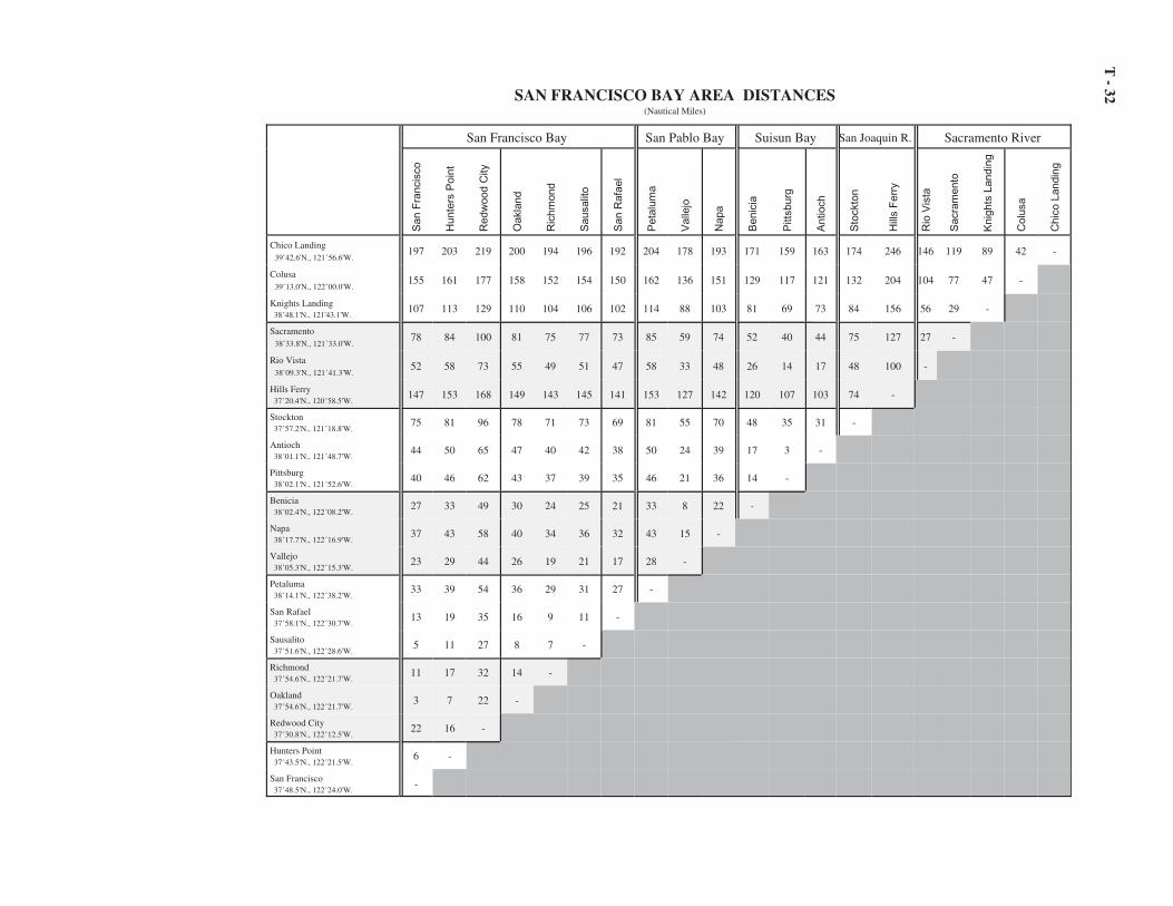
T -
32SAN FRANCISCO BAY AREA DISTANCES(Nautical Miles)
San Francisco Bay San Pablo Bay Suisun Bay San Joaquin R. Sacramento River
San F
rancis
co
Hunte
rs P
oin
t
Redw
ood C
ity
Oakla
nd
Ric
hm
ond
Sausalit
o
San R
afa
el
Peta
lum
a
Valle
jo
Napa
Benic
ia
Pitts
burg
Antioch
Sto
ckto
n
Hill
s F
err
y
Rio
Vis
ta
Sacra
mento
Knig
hts
Landin
g
Colu
sa
Chic
o L
andin
g
Chico Landing 39�42.6'N., 121�56.6'W.
197 203 219 200 194 196 192 204 178 193 171 159 163 174 246 146 119 89 42 -
Colusa 39�13.0'N., 122�00.0'W.
155 161 177 158 152 154 150 162 136 151 129 117 121 132 204 104 77 47 -
Knights Landing 38�48.1'N., 121'43.1'W.
107 113 129 110 104 106 102 114 88 103 81 69 73 84 156 56 29 -
Sacramento 38�33.8'N., 121�33.0'W.
78 84 100 81 75 77 73 85 59 74 52 40 44 75 127 27 -
Rio Vista 38�09.3'N., 121�41.3'W.
52 58 73 55 49 51 47 58 33 48 26 14 17 48 100 -
Hills Ferry 37�20.4'N., 120�58.5'W.
147 153 168 149 143 145 141 153 127 142 120 107 103 74 -
Stockton 37�57.2'N., 121�18.8'W.
75 81 96 78 71 73 69 81 55 70 48 35 31 -
Antioch 38�01.1'N., 121�48.7'W.
44 50 65 47 40 42 38 50 24 39 17 3 -
Pittsburg 38�02.1'N., 121�52.6'W.
40 46 62 43 37 39 35 46 21 36 14 -
Benicia 38�02.4'N., 122�08.2'W.
27 33 49 30 24 25 21 33 8 22 -
Napa 38�17.7'N., 122�16.9'W.
37 43 58 40 34 36 32 43 15 -
Vallejo 38�05.3'N., 122�15.3'W.
23 29 44 26 19 21 17 28 -
Petaluma 38�14.1'N., 122�38.2'W.
33 39 54 36 29 31 27 -
San Rafael 37�58.1'N., 122�30.7'W.
13 19 35 16 9 11 -
Sausalito 37�51.6'N., 122�28.6'W.
5 11 27 8 7 -
Richmond 37�54.6'N., 122�21.7'W.
11 17 32 14 -
Oakland 37�54.6'N., 122�21.7'W.
3 7 22 -
Redwood City 37�30.8'N., 122�12.5'W.
22 16 -
Hunters Point 37�43.5'N., 122�21.5'W.
6 -
San Francisco 37�48.5'N., 122�24.0'W.
-

T -
33
DISTANCES ON COLUMBIA RIVER SYSTEM(Nautical and Statute Miles)
Jo
hn
so
n B
ar
La
nd
ing
, ID
Le
wis
ton
, ID
Ce
ntr
al F
err
y,
WA
Ice
Ha
rbo
r D
am
, W
A
Ha
rris
bu
rg,
OR
Co
rva
lis,
OR
Alb
an
y,
OR
Sa
lem
, O
R
Ore
go
n C
ity,
OR
Po
rtla
nd
, O
R
Ric
hla
nd
, W
A
Pa
sco
, W
A
Po
rt o
f W
alla
Wa
lla,
WA
McN
ary
Lo
ck &
Da
m
Um
atilla
, O
R
Arl
ing
ton
, O
R
Jo
hn
Da
y L
ock &
Da
m
Th
e D
alle
s L
ock &
Da
m
Ho
od
Riv
er
(to
wn
), O
R
Bo
nn
evill
e L
ock &
Da
m
Va
nco
uve
r, W
A
St.
He
len
s,
OR
Lo
ng
vie
w,
WA
Asto
ria
, O
R
Wa
rre
nto
n,
OR
Ilw
aco
, W
A
Co
lum
bia
Riv
er
Mo
uth
Colu
mbia
Riv
er
Columbia River Mouth 46�14.8'N., 124�05.5'W.
483 404 354 291 230 203 192 162 110 97 293 285 276 254 251 210 188 166 148 126 92 75 58 12 11 6 -
Ilwaco, WA 484 404 355 292 230 203 193 163 111 98 294 286 276 254 252 211 189 167 149 127 93 76 59 13 12 - 7
Warrenton, OR 475 396 346 283 222 195 184 154 103 89 285 277 268 246 244 202 180 159 140 118 84 67 50 4 - 14 13
Astoria, OR 470 391 342 278 217 190 180 149 98 85 281 273 263 241 239 198 175 154 136 114 80 62 45 - 5 15 14
Longview, WA 425 345 296 233 171 144 134 104 52 39 235 227 217 195 193 152 130 108 90 68 34 17 - 52 58 68 67
St. Helens, OR 411 332 282 219 158 131 121 90 39 25 222 214 204 182 180 138 117 95 76 55 20 - 20 71 77 87 86
Vancouver, WA 391 312 262 199 145 118 108 77 26 13 202 193 184 162 160 118 96 75 56 35 - 23 39 92 97 107 106
Bonneville Lock & Dam 356 277 228 164 180 153 142 112 61 47 167 159 149 127 125 84 62 40 22 - 40 63 78 131 136 146 145
Hood River (town), OR 335 256 206 143 201 174 164 134 82 69 145 137 128 106 103 62 40 18 - 25 64 87 104 157 161 171 170
The Dalles Lock & Dam 316 237 188 124 220 193 183 152 101 87 127 119 109 87 85 44 22 - 21 46 86 109 124 177 183 192 191
John Day Lock & Dam 294 215 166 102 242 215 204 174 123 109 105 97 87 65 63 22 - 25 46 71 110 135 150 203 207 217 216
Arlington, OR 273 194 144 81 263 236 226 195 144 130 83 75 66 44 42 - 25 51 71 97 136 159 175 228 232 243 242
Umatilla, OR 231 152 103 39 305 278 268 237 186 172 42 34 24 2 - 48 72 98 119 144 184 207 222 275 281 290 289
McNary Lock & Dam 229 150 101 37 307 280 270 239 188 174 40 32 22 - 2 51 75 100 122 146 186 209 224 277 283 292 292
Port of Walla Walla, WA 207 128 79 15 329 302 292 261 210 196 18 10 - 25 28 76 100 125 147 171 212 235 250 303 308 318 318
Pasco, WA 204 125 75 12 339 312 301 271 220 206 8 - 12 37 39 86 112 137 158 183 222 246 261 314 319 329 328
Will
am
ett
e R
iver
Richland, WA 212 133 83 20 347 320 309 279 228 214 - 9 21 46 48 96 121 146 167 192 232 255 270 323 328 338 337
Portland, OR 403 324 275 211 133 106 96 65 14 - 246 237 226 200 198 150 125 100 79 54 15 29 45 98 102 113 112
Oregon City, OR 417 338 288 225 119 92 82 51 - 16 262 253 242 216 214 166 142 116 94 70 30 45 60 113 119 128 127
Salem, OR 468 389 340 276 68 41 31 - 59 75 321 312 300 275 273 224 200 175 154 129 89 104 120 171 177 188 186
Albany, OR 499 420 370 307 37 10 - 36 94 110 356 346 336 311 308 260 235 211 189 163 124 139 154 207 212 222 221
Corvalis, OR 509 430 380 317 27 - 12 47 106 122 368 359 348 322 320 272 247 222 200 176 136 151 166 219 224 234 234
Harrisburg, OR 536 457 407 344 - 31 43 78 137 153 399 390 379 353 351 303 278 253 231 207 167 182 197 250 255 265 265
Snake R
iver Ice Harbor Dam, WA 192 113 63 - 396 365 353 318 259 243 23 14 17 43 45 93 117 143 165 189 229 252 268 320 326 336 335
Central Ferry, WA 129 50 - 72 468 437 426 391 331 316 96 86 91 116 119 166 191 216 237 262 302 325 341 394 398 409 407
Lewiston, ID 79 - 58 130 526 495 483 448 389 373 153 144 147 173 175 223 247 273 295 319 359 382 397 450 456 465 465
Johnson Bar Landing, ID - 91 148 221 617 586 574 539 480 464 244 235 238 264 266 314 338 364 386 410 450 473 489 541 547 557 556
Nautical miles on top (upright text)
Statute miles on the bottom (shaded, slant text)

T -
34
DISTANCES IN STRAIT OF JUAN DE FUCA AND STRAIT OF GEORGIA(Nautical Miles)
Va
nco
uve
r, B
C,
Ca
na
da
Ne
w W
estm
inste
r, B
C,
Ca
na
da
Na
na
imo
, B
C,
Ca
na
da
Bla
ine
, W
A
Be
llin
gh
am
, W
A
An
aco
rte
s,
WA
Fri
da
y H
arb
or,
WA
Ro
ch
e H
arb
or,
WA
Oly
mp
ia,
WA
Ta
co
ma
, W
A
Bre
me
rto
n,
WA
Ea
gle
Ha
rbo
r, W
A
Se
att
le,
WA
Po
int W
ells
, W
A
Eve
rett
, W
A
Po
rt G
am
ble
, W
A
Po
rt L
ud
low
, W
A
Po
rt T
ow
nse
nd
, W
A
Vic
toria
, B
C,
Ca
na
da
Po
rt A
ng
ele
s,
WA
Ne
ah
Ba
y,
WA
Sw
ifts
ure
Ba
nk,
WA
Ca
pe
Fla
tte
ry,
WA
Cape Flattery, WA 48�26.0'N., 124�47.0'W.
141 139 145 112 108 93 87 83 168 143 131 123 124 111 117 104 100 86 62 61 10 10 -
Swiftsure Bank, WA 48�31.0'N., 125�00.0'W.
150 148 154 121 117 102 96 92 178 153 141 133 134 121 127 114 110 96 71 71 20 -
Neah Bay, WA 48�22.4'N., 124�36.5'W.
133 132 138 105 101 86 80 76 160 136 124 115 116 103 110 97 93 79 55 54 -
Port Angeles, WA 48�07.5'N., 123�26.4'W.
95 93 99 65 54 42 37 36 113 89 77 68 69 56 63 50 46 32 19 -
Victoria, BC, Canada 48�25.0'N., 123�23.5'W.
83 82 89 55 50 36 30 25 115 91 80 71 72 59 66 53 48 34 -
Port Townsend, WA 48�06.8N., 122�45.2'W.
92 91 97 59 43 30 30 41 84 59 48 40 40 27 34 21 16 -
Port Ludlow, WA 47�55.3'N., 122�41.0'W.
106 105 111 72 57 43 44 54 75 52 40 32 32 19 26 10 -
Port Gamble, WA 47�51.3'N., 122�34.7'W.
110 109 115 76 61 47 48 58 78 53 42 34 34 21 28 -
Everett, WA 47�59.3'N., 122�13.2'W.
115 114 118 80 63 49 62 71 73 49 38 29 30 16 -
Point Wells, WA 47�47.1'N., 122�23.7'W.
117 116 121 83 68 54 54 64 59 34 23 14 14 -
Seattle, WA 47�36.2'N., 122�20.3'W.
129 128 134 95 80 66 67 77 50 25 14 8 -
Eagle Harbor, WA 47�34.2'N.,122�30.7'W.
129 128 134 95 80 66 67 76 50 25 13 -
Bremerton, WA 47�33.5'N., 122�38.0'W.
138 137 142 104 88 74 76 85 50 29 -
Tacoma, WA 47�16.0'N., 122�26.0'W.
149 148 154 115 100 86 86 96 34 -
Olympia, WA 47�03.1'N., 122�54.3'W.
173 171 177 139 124 110 112 121 -
Roche Harbor, WA 48�36.6'N., 123�09.1W.
62 60 66 35 37 27 12 -
Friday Harbor, WA 48�32.2'N., 123�00.9'W.
62 60 69 37 28 18 -
Anacortes, WA 48�31.4'N., 122�36.7'W.
71 70 76 36 17 -
Bellingham, WA 48�45.1'N., 122�29.0'W.
72 71 75 38 -
Blaine, WA 48�59.5'N., 122�45.9'W.
48 48 55 -
Nanaimo, BC, Canada 49�10.1'N., 123�56.0'W.
36 48 -
New Westminster, BC, Canada 49�12.0'N., 122�54.5'W.
41 -
Vancouver, BC, Canada 49�17.4'N., 123�06.6'W.
-

T -
35
HAWAII DISTANCES(Nautical Miles)
Palm
yra
Isla
nd
Johnsto
n I
sla
nd
Mid
way I
sla
nd
Nonopapa,
Nih
au
Hanale
i, K
auai
Waim
ea,
Kauai
Port
Alle
n,
Kauai
Naw
iliw
ili,
Kauai
Ahukin
i, K
auai
Pearl H
arb
or,
Oahu
Honolu
lu,
Oahu
Kala
upapa,
Molo
kai
Hale
olo
no,
Molo
kai
Kaunakakai, M
olo
kai
Kam
alo
, M
olo
kai
Kaum
ala
pau,
Lanai
Kahalu
i, M
aui
Lahain
a (
Mala
),M
aui
Hana,
Maui
Mahukona,
Haw
aii
Kaw
aih
ae,
Haw
aii
Kailu
a,
Haw
aii
Napoopoo,
Haw
aii
Hilo
, H
aw
aii
Hilo, Hawaii 19�44.1'N., 155�03.5'W.
959 905 1338 332 308 303 297 287 287 201 196 154 155 145 137 136 121 125 85 72 83 109 120 -
Napoopoo, Hawaii 19�28.6'N., 155�55.3'W.
- - - 287 266 260 254 244 245 162 157 138 124 120 112 101 120 99 84 50 45 11 -
Kailua, Hawaii 19�38.6'N., 156�00.0'W.
- - - 278 257 251 245 235 236 152 147 127 114 109 102 91 110 88 73 39 34 -
Kawaihae, Hawaii 20�02.3'N., 155�49.9'W.
928 811 1278 277 251 246 240 230 230 145 140 110 103 93 86 82 85 72 48 12 -
Mahukona, Hawaii 20�11.2'N., 155�54.2'W.
- - - 272 244 239 233 223 223 138 133 102 95 85 77 76 74 63 36 -
Hana, Maui 20�45.6'N., 155�59.1'W.
- - - 262 224 226 220 210 210 124 119 70 80 69 59 72 37 57 -
Lahaina (Mala), Maui 20�53.5'N., 156�41.5'W.
- - - 214 186 182 177 165 165 78 73 39 34 23 15 25 27 -
Kahalui, Maui 20�54.0'N., 156�28.2'W.
1010 798 1232 232 194 199 193 181 181 94 89 41 50 39 30 50 -
Kaumalapau, Lanai 20�47.4'N., 156�59.7'W.
- - - 199 172 167 161 151 151 65 60 54 24 21 25 -
Kamalo, Molokai 21�02.9'N., 156�52.7'W.
- - - 203 173 169 163 153 153 66 61 37 22 12 -
Kaunakakai, Molokai 21�05.1'N., 157�02.0'W.
- - - 193 164 160 154 144 144 57 52 45 13 -
Haleolono, Molokai 21�05.2'N., 157�15.2'W.
- - - 181 152 148 142 132 132 45 40 33 -
Kalaupapa, Molokai 21�11.7'N., 156�59.3'W.
- - 194 159 162 156 144 143 58 53 -
Honolulu, Oahu 21�18.5'N., 157�52.3'W.
959 725 1150 147 116 112 106 96 96 9 -
Pearl Harbor, Oahu 21�20.0'N., 157�58.3'W.
960 722 1146 143 112 108 102 92 92 -
Ahukini, Kauai 21�59.7'N., 159�20.1'W.
- - - 65 29 29 23 5 -
Nawiliwili, Kauai 21�57.4'N., 159�21.5'W.
986 668 1069 63 32 27 21 -
Port Allen, Kauai 21�54.1'N., 159�35.6'W.
979 656 1042 45 42 8 -
Waimea, Kauai 21�57.4'N., 159�40.4'W.
- - - 40 35 -
Hanalei, Kauai 22�12.9'N., 159�30.1'W.
- - - 52 -
Nonopapa, Nihau 21�52.0'N., 160�14.1'W.
- - - --
Midway Island 28�13.0'N., 177�22.0'W.
1606 825 -
Johnston Island 16�44.6'N., 169�31.2'W.
785 -
Palmyra Island 5�52.5'N., 162�08.0'W.
-

T -
36GULF OF ALASKA DISTANCES(Nautical Miles)
Uni
mak
Pas
s
Fals
e Pa
ss
Ung
a
Chi
gnik
Uya
k
Kod
iak
Anc
hora
ge
Hom
er
Seld
ova
Sew
ard
Lat
ouch
e
Whi
ttier
Port
Val
dez
Cor
dova
Yak
utat
Cap
e Sp
ence
r
Sitk
a
Cap
e D
ecis
ion
Dix
on E
ntra
nce
Swif
tsur
e B
ank
Swiftsure Bank 48º31.0'N., 125º00.0'W.
1510 1473 1394 1301 1200 1124 1294 1178 1167 1100 1076 1113 1100 1093 869 739 681 588 500 -
Dixon Entrance 54º28.0'N., 132º52.0'W.
1120 1064 953 874 762 687 845 729 718 642 617 647 634 627 402 259 192 106 -
Cape Decision 55º59.4'N., 134º08.1'W.
1064 1016 892 811 689 613 763 647 636 553 527 542 529 522 295 162 95 -
Sitka 57º03.1'N., 135º20.5'W.
1027 980 865 772 628 564 708 591 580 494 467 492 479 472 231 85 -
Cape Spencer 58º10.0'N., 136º38.3'W.
987 926 811 717 571 505 641 525 514 422 395 413 400 393 141 -
Yakutat 59º32.9'N., 139º43.9'W.
897 844 730 636 480 414 538 422 411 312 286 298 285 278 -
Cordova 60º33.4'N., 145º45.3'W.
763 711 597 503 339 282 387 270 260 146 85 96 78 -
Port Valdez 61º06.0'N., 146º24.0'W
761 709 595 501 337 280 385 267 257 144 83 96 -
Whittier 60º46.8'N., 148º39.6'W.
742 689 574 481 317 261 367 249 239 125 64 -
Latouche 60º03.3'N., 147º54.1'W.
678 626 511 418 254 201 300 183 172 61 -
Seward 60º006.0'N., 149º26.0'W.
652 600 485 392 228 175 274 158 147 -
Seldova 59º26.5'N., 151º43.0'W.
562 510 395 302 138 115 139 16 -
Homer 59º36.0'N., 151º24.0'W.
573 521 406 313 149 126 143 -
Anchorage 61º14.2'N., 149º53.3'W.
688 636 521 428 264 242 -
Kodiak 57º47.1'N., 152º25.1'W.
505 453 338 245 80 -
Uyak 57º38.6'N., 154º00.0'W.
440 388 273 180 -
Chignik 56º17.8'N., 158º24.0'W.
289 236 122 -
Unga 55º10.6N., 160º29.8'W.
187 135 -
False Pass 54º51.4'N., 163º24.0'W.
86 -
Unimak Pass 54º20.0'N., 164º45.0'W.
-

T -
37
INSIDE-PASSAGE DISTANCESSeattle, Washington, to Cape Spencer, Alaska
(Nautical Miles)
Cap
e Sp
ence
r, A
K
Gus
tavu
s, A
K
Skag
way
, AK
Hai
nes,
AK
June
au, A
K
Pelic
an, A
K
Sitk
a, A
K
Pete
rsbu
rg, A
K
Port
Ale
xand
er, A
K
Cap
e D
ecis
ion,
AK
Wra
ngel
l, A
K
Cra
ig, A
K
Ket
chik
an, A
K
Met
laka
tla, A
K
Cap
e C
haco
n, A
K
Hyd
er, A
K
Dix
on E
ntra
nce,
B.C
.
Vic
tori
a, B
.C.
Seat
tle, W
A
Seattle, WA 47º36.2'N., 122º20.3'W.
976 938 962 950 879 989 883 771 812 788 749 716 659 660 640 690 664 72 -
Victoria, B.C. 48º25.0'N., 123º28.5'W.
924 886 910 898 827 937 832 719 761 737 697 664 608 608 588 638 612 -
Dixon Entrance, AK 54º28.0'N., 132º52.0'W.
319 290 371 359 288 332 221 180 150 126 157 77 79 66 34 169 -
Hyder, AK 55º54.2'N., 130º00.6'W.
451 423 447 435 364 464 368 256 297 273 234 212 144 148 136 -
Cape Chacon, AK 54º40.6'N., 131º59.7'W.
318 289 337 325 254 331 220 146 149 125 123 76 45 32 -
Metlakatla, AK 55º07.8'N., 131º34.2'W.
321 293 317 305 235 334 238 126 167 143 104 109 16 -
Ketchikan, AK 55º20.5'N., 131º38.7'W.
307 278 303 291 220 320 224 112 153 129 89 121 -
Craig, AK 55º28.7'N., 133º09.7'W
242 213 264 253 206 255 144 113 73 49 111 -
Wrangell, AK 56º28.2'N., 132º23.2'W.
235 208 231 219 148 248 170 40 99 75 -
Cape Decision, AK 55º59.4'N., 134º08.1'W.
193 164 215 204 157 206 95 76 24 -
Port Alexander, AK 56º14.8'N., 134º38.8'W.
173 147 198 186 140 186 82 100 -
Petersburg, AK 56º48.9'N., 132º57.8'W.
195 166 191 179 108 207 159 -
Sitka, AK 57º03.1'N., 135º20.5'W.
85 136 187 176 162 79 -
Pelican, AK 57º57.6'N., 136º13.8'W.
18 45 148 136 123 -
Juneau, AK 58º17.9'N., 134º24.7'W.
110 82 100 88 -
Haines, AK 59º13.8'N., 135º26.1'W.
124 96 14 -
Skagway, AK 59º26.8'N., 135º19.3'W.
136 106 -
Gustavus, AK 58º23.3N., 135º43.6'W.
32 -
CAPE SPENCER, AK 58º10.0'N., 136º38.3'W.
-

T - 38
DISTANCES ON YUKON RIVER, ALASKA
(Nautical Miles)
Apoon Pass (63°02.6'N., 163°22.3'W.) to:Hamilton. . . . . . . . . . . . . . . . . . . . . . . . . . . . . . . . . . . . . . . . . . . . . . . . . . . . . . . . . . . . 22Azacharak . . . . . . . . . . . . . . . . . . . . . . . . . . . . . . . . . . . . . . . . . . . . . . . . . . . . . . . . . . 85Pilot Station . . . . . . . . . . . . . . . . . . . . . . . . . . . . . . . . . . . . . . . . . . . . . . . . . . . . . . . . 115Marshall . . . . . . . . . . . . . . . . . . . . . . . . . . . . . . . . . . . . . . . . . . . . . . . . . . . . . . . . . . . 153Russian Mission . . . . . . . . . . . . . . . . . . . . . . . . . . . . . . . . . . . . . . . . . . . . . . . . . . . . . 195Paimiut . . . . . . . . . . . . . . . . . . . . . . . . . . . . . . . . . . . . . . . . . . . . . . . . . . . . . . . . . . . . 231Holy Cross . . . . . . . . . . . . . . . . . . . . . . . . . . . . . . . . . . . . . . . . . . . . . . . . . . . . . . . . . 257Anvik. . . . . . . . . . . . . . . . . . . . . . . . . . . . . . . . . . . . . . . . . . . . . . . . . . . . . . . . . . . . . . 292Kaltag . . . . . . . . . . . . . . . . . . . . . . . . . . . . . . . . . . . . . . . . . . . . . . . . . . . . . . . . . . . . . 409Nulato . . . . . . . . . . . . . . . . . . . . . . . . . . . . . . . . . . . . . . . . . . . . . . . . . . . . . . . . . . . . . 438Koyukuk . . . . . . . . . . . . . . . . . . . . . . . . . . . . . . . . . . . . . . . . . . . . . . . . . . . . . . . . . . . 453Galena. . . . . . . . . . . . . . . . . . . . . . . . . . . . . . . . . . . . . . . . . . . . . . . . . . . . . . . . . . . . . 481Ruby . . . . . . . . . . . . . . . . . . . . . . . . . . . . . . . . . . . . . . . . . . . . . . . . . . . . . . . . . . . . . . 526Kokrines . . . . . . . . . . . . . . . . . . . . . . . . . . . . . . . . . . . . . . . . . . . . . . . . . . . . . . . . . . . 556Tanana . . . . . . . . . . . . . . . . . . . . . . . . . . . . . . . . . . . . . . . . . . . . . . . . . . . . . . . . . . . . 628Rampart . . . . . . . . . . . . . . . . . . . . . . . . . . . . . . . . . . . . . . . . . . . . . . . . . . . . . . . . . . . 688Stevens . . . . . . . . . . . . . . . . . . . . . . . . . . . . . . . . . . . . . . . . . . . . . . . . . . . . . . . . . . . . 762Beaver . . . . . . . . . . . . . . . . . . . . . . . . . . . . . . . . . . . . . . . . . . . . . . . . . . . . . . . . . . . . . 835Fort Yukon . . . . . . . . . . . . . . . . . . . . . . . . . . . . . . . . . . . . . . . . . . . . . . . . . . . . . . . . . 896Circle. . . . . . . . . . . . . . . . . . . . . . . . . . . . . . . . . . . . . . . . . . . . . . . . . . . . . . . . . . . . . . 959Coal Creek. . . . . . . . . . . . . . . . . . . . . . . . . . . . . . . . . . . . . . . . . . . . . . . . . . . . . . . . 1,002Nation . . . . . . . . . . . . . . . . . . . . . . . . . . . . . . . . . . . . . . . . . . . . . . . . . . . . . . . . . . . 1,047Eagle . . . . . . . . . . . . . . . . . . . . . . . . . . . . . . . . . . . . . . . . . . . . . . . . . . . . . . . . . . . . 1,089U.S.–Canada International Boundary . . . . . . . . . . . . . . . . . . . . . . . . . . . . . . . . . 1,099Fortymile, Canada . . . . . . . . . . . . . . . . . . . . . . . . . . . . . . . . . . . . . . . . . . . . . . . . . 1,149Dawson, Canada . . . . . . . . . . . . . . . . . . . . . . . . . . . . . . . . . . . . . . . . . . . . . . . . . . . 1,197
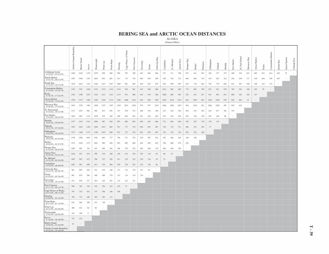
T -
39
BERING SEA and ARCTIC OCEAN DISTANCESALASKA
(Nautical Miles)
Ala
ska-
Can
ada
Bou
ndar
y
Bar
ter
Isla
nd
Bar
row
Wai
nwri
ght
Poin
t Lay
Poin
t Hop
e
Dee
ring
Cap
e Pr
ince
of
Wal
es
Por
t Cla
renc
e
Savo
onga
Nom
e
Gol
ovni
n B
ay
Una
lakl
eet
St.
Mic
hael
Apo
on P
ass
Hoo
per
Bay
Bet
hel
Plat
inum
Dill
ingh
am
Nak
nek
Mes
hik
Por
t Mol
ler
St.
Pau
l Isl
and
Mas
sacr
e B
ay
Alc
an H
arbo
r
Kis
ka
Con
stan
tine
Har
bor
Kul
uk B
ay
Dut
ch H
arbo
r
Uni
mak
Pas
s
UNIMAK PASS 54�20.0'N., 164�45.0'W.
1490 1428 1155 1079 998 868 900 702 708 642 646 686 737 711 708 472 421 307 384 377 277 208 254 833 805 672 614 463 75 -
Dutch Harbor 53�52.7'N., 166�31.8'W.
1503 1440 1167 1092 1011 881 913 715 720 654 659 699 750 724 721 485 464 343 432 425 325 256 239 777 749 616 558 407 -
Kuluk Bay 51�51.6'N., 176�37.6'W.
1678 1616 1343 1268 1187 1057 1089 891 896 830 835 875 926 900 897 678 776 662 785 779 694 627 387 396 368 235 175 -
Constantine Harbor 51�24.0'N., 179�18.1'W.
1763 1701 1428 1353 1272 1142 1174 976 981 915 920 960 1011 985 982 775 903 789 919 912 832 769 501 249 222 79 -
Kiska 51�58.3'N., 177�34.5'W.
1762 1700 1427 1352 1271 1141 1173 975 980 914 919 958 1009 984 981 783 931 817 951 945 871 809 526 185 157 -
Alcan Harbor 52�44.0'N., 174�04.5'W.
1795 1733 1460 1385 1304 1174 1206 1008 1013 945 950 990 1044 1018 1015 830 1007 893 1036 1029 978 920 604 33 -
Massacre Bay 52�48.9'N., 173�15.6'W.
1819 1756 1483 1408 1327 1197 1229 1031 1036 970 975 1015 1066 1040 1037 854 1034 921 1062 1056 991 934 632 -
St. Paul Island 57�07.6'N., 170�17.9'W.
1317 1255 982 906 825 695 727 529 535 468 470 504 555 529 528 304 415 302 444 437 381 335 -
Port Moller 55�59.0'N., 160�36.5'W.
1469 1407 1134 1059 978 848 880 682 687 621 618 652 703 678 676 452 310 196 207 198 88 -
Meshik 56�56.5'N., 158�49.0'W.
1477 1414 1141 1066 985 855 887 689 695 628 625 660 712 685 684 459 293 179 130 118 -
Naknek 58�41.5'N., 157�16.0'W.
1507 1442 1169 1094 1012 883 915 717 722 656 653 687 738 712 711 486 315 202 72 -
Dillingham 59�02.0'N., 158�29.0'W.
1513 1448 1175 1100 1019 889 921 723 728 662 659 693 744 719 718 493 322 208 -
Platinum 59�01.5'N., 161�52.0'W.
1358 1296 1023 948 866 737 769 571 576 510 507 541 592 566 565 340 120 -
Bethel 60�49.0'N., 161�47.0'W.
1472 1410 1137 1061 980 850 883 685 690 624 620 655 706 680 679 454 -
Hooper Bay 61�29.0'N., 166�04.0'W.
1058 995 722 647 566 436 468 270 276 209 200 235 286 260 259 -
Apoon Pass 63�02.6'N., 163�22.3'W.
1010 947 674 599 518 388 420 222 228 229 116 85 88 53 -
St. Michael 63�32.4'N., 161�54.8'W.
1007 945 672 596 515 385 417 219 225 230 110 59 35 -
Unalakleet 63�53.0'N., 160�50.0'W.
1025 963 690 615 534 404 436 238 244 254 126 66 -
Golovnin Bay 64�22.3'N., 163�06.7'W.
961 899 626 551 470 340 372 174 179 197 62 -
Nome 64�29.0'N., 165�26.0'W.
901 839 566 490 409 279 312 114 119 139 -
Savoonga 63�43.0'N., 170�27.0'W.
912 850 577 502 420 291 323 125 151 -
Port Clarence 65�17.1'N., 166�24.5'W.
846 783 510 435 354 223 255 57 -
Cape Prince of Wales 65�37.6'N., 168�31.5'W.
787 725 452 377 296 166 198 -
Deering 66�06.0'N., 162�44.0'W.
794 732 458 383 302 172 -
Point Hope 68�21.0'N., 167�18.0'W.
621 560 286 211 130 -
Point Lay 68�21.0'N., 163�08.0'W.
496 434 161 86 -
Wainwright 70�40.0'N., 160�00.0'W.
412 350 77 -
Barrow 71�18.0'N., 156�48.0'W. 337 274 -
Barter Island 70�09.0'N., 143�40.0'W.
62 -
Alaska-Canada Boundary 69�43.0'N., 141�00.0'W.
-

T -
40Table For Estimating Time of Transit
Distance
Speed in knots
8 9 10 11 12 13 14 15 16 17 18 19 20 21 22 23 24 25 30
Nautical
Miles
102030
405060
708090
100200300
400500600
700800900
1,0002,0003,000
4,0005,0006,000
Days-
hours
0-10-30-4
0-50-60-8
0-90-100-11
0-131-1
1-14
2-22-153-3
3-164-4
4-17
5-510-1015-15
20-2026-131-6
Days-
hours
0-10-20-3
0-40-60-7
0-80-9
0-10
0-110-221-9
1-202-8
2-19
3-63-174-4
4-159-6
13-21
18-2123-427-19
Days-
hours
0-10-20-3
0-40-50-6
0-70-80-9
0-100-201-6
1-162-2
2-12
2-223-8
3-18
4-48-8
12-12
16-1620-2025-0
Days-
hours
0-10-20-3
0-40-50-5
0-60-70-8
0-90-181-3
1-121-212-7
2-163-1
3-10
3-197-1411-9
15-418-2322-17
Days-
hours
0-10-20-2
0-30-40-5
0-60-70-8
0-80-171-1
1-91-182-2
2-102-193-3
3-116-2310-10
13-2117-920-20
Days-
hours
0-10-20-2
0-30-40-5
0-50-60-7
0-80-150-23
1-71-141-22
2-62-142-21
3-56-109-15
12-2016-119-6
Days-
hours
0-10-10-2
0-30-40-4
0-50-60-6
0-70-140-21
1-51-121-19
2-22-9
2-16
2-235-238-22
11-2214-2117-21
Days-
hours
0-10-10-2
0-30-30-4
0-50-50-6
0-70-130-20
1-31-9
1-16
1-232-5
2-12
2-195-138-8
11-313-2116-16
Days-
hours
0-10-10-2
0-30-30-4
0-40-50-6
0-60-130-19
1-11-7
1-14
1-202-22-8
2-155-5
7-20
10-1013-115-15
Days-
hours
0-10-10-2
0-20-30-4
0-40-50-5
0-60-120-18
1-01-5
1-11
1-171-232-5
2-114-227-8
9-1912-614-17
Days-
hours
0-10-10-2
0-20-30-3
0-40-40-5
0-60-110-17
0-221-41-9
1-151-202-2
2-84-156-23
9-611-1413-21
Days-
hours
0-10-10-2
0-20-30-3
0-40-40-5
0-50-110-16
0-211-21-8
1-131-181-23
2-54-9
6-14
8-1910-2313-4
Days-
hours
0-10-10-2
0-20-30-3
0-40-40-5
0-50-100-15
0-201-11-6
1-111-161-21
2-24-46-6
8-810-1012-12
Days-
hours
.....0-10-1
0-20-20-3
0-30-40-4
0-50-100-14
0-191-01-5
1-91-141-19
2-03-235-23
7-229-2211-22
Days-
hours
.....0-10-1
0-20-20-3
0-30-40-4
0-50-9
0-14
0-180-231-3
1-81-121-17
1-213-195-16
7-149-1111-9
Days-
hours
.....0-10-1
0-20-20-3
0-30-30-4
0-40-9
0-13
0-170-221-2
1-61-111-15
1-193-155-10
7-69-1
10-21
Days-
hours
.....0-10-1
0-20-20-3
0-30-30-4
0-40-8
0-13
0-170-211-1
1-51-9
1-14
1-183-115-5
6-238-1610-10
Days-
hours
.....0-10-1
0-20-20-2
0-30-30-4
0-40-8
0-12
0-160-201-0
1-41-8
1-12
1-163-85-0
6-168-8
10-0
Days-
hours
.....0-10-1
0-10-20-2
0-20-30-3
0-30-7
0-10
0-130-170-20
0-231-31-6
1-92-194-4
5-136-238-8

T - 41
Measurement and Conversion Factors
Equivalencies
nautical mile 1,852.0 meters6,076.12 feet
statute mile 5,280 feet;1,609.3 meters;1.6 093 kilometers
cable 0.1 nautical mile (Canada);720 feet (U.S.)
fathom 6 feet;1.8 288 meters
foot 0.3 048 meter
inch 2.54 centimeters
meter 39.37 inches;3.281 feet;1.0 936 yards
kilometer 1,000 meters
knot 1.6 877 feet per second0.5 144 meters per second
miles (statute) per hour 1.466 feet per second0.44 704 meters per second
acre 43,560 square feet4,046.82 square meters
pound (avoirdupois) 453.59 gram
gram 0.0 022 046 pound (avoirdupois)
short ton 2,000 pounds
long ton 2,240 pounds
metric ton 2,204.6 pounds;
gram 0.035 274 ounce
kilogram 2.2 pounds
liter 1.0 567 quarts
barrel (petroleum) 42 gallons (U.S.)

T - 42
Conversion Factors
Symbol When you know Multiply by To find Symbol
Linear
in inches 25.40 millimeters mmin inches 2.540 centimeters cmcm centimeters 0.032 808 feet ftft feet 30.48 centimeters cmft feet 0.3 048 meters mft feet 0.00 016 458 nautical miles nmyd yards 0.9 144 meters mm meters 3.2 808 feet ftm meters 1.094 yards ydm meters 0.0 005 399 nautical miles nmsm statute miles 0.86 897 nautical miles nmsm statute miles 1.6 093 kilometers kmsm statute miles 1,609.3 meters mnm nautical miles 1.151 statute miles sm
Area
ft2 square feet 0.0 929 square meters m2
m2 square meters 10.764 square feet ft2
acres 4,046.9 square meters m2
acres 43,560 square feet ft2
m2 square meters 0.0 002 471 acresft2 square feet 0.00 002 296 acresha hectare 2.471 054 acreha hectare 10,000 square meters m2
ha hectare 1.07 639x105 square feet ft2
acre 0.404 685 hectare ha
Depths
fathoms 1.8 288 meters mm meters 0.54 681 fathomsm meters 3.2 808 feet ftft feet 0.3 048 meters m

T - 43
Conversion Factors (continued)
Symbol When you know Multiply by To find Symbol
Rates
ft/sec feet per second 0.5 925 knots ktft/sec feet per second 0.6 818 miles per hour mphft/sec feet per second 30.48 centimeters per second cm/smph statute miles per hour 0.8 689 knots ktmph statute miles per hour 1.467 feet per second fpsmph statute miles per hour 0.447 meters per second m/skt knots 1.151 miles per hour mphkt knots 0.5 144 meters per second m/skt knots 1.6 878 feet per second fpscm/sec centimeter per second 0.01 944 knots ktcm/sec centimeter per second 0.02 237 miles per hour mphcm/sec centimeter per second 0.032 808 feet per second fps
Mass
g grams 0.035 275 ounces (avoirdupois) ozg grams 0.002 205 pounds (avoirdupois) lboz ounces (avoirdupois) 28.349 grams glb pounds 0.45 359 kilograms kg
short tons 2,000 pounds Lbshort tons 0.89 286 long tonsshort tons 0.9 072 metric tons tlong tons 2,240 pounds Lblong tons 1.12 short tonslong tons 1.016 metric tons t
t metric tons 1,000 kilograms kgt metric tons 0.9 842 long tonst metric tons 1.1 023 short tonst metric tons 2,204.6 pounds Lb
Volume
barrels (petroleum) 42 gallons (U.S.) galbarrels (petroleum) 158.99 liters Lbarrels (liquid, U.S.) 31.5 gallons (U.S.) galbarrels (liquid, U.S.) 26.229 gallons (British) galbarrels (liquid, U.S.) 119.24 liters L
gal gallons (U.S.) 0.02 381 barrels (petroleum)L liters 0.26 417 gallons (U.S.) Galgal gallons (U.S.) 3.7 854 liters L
Temperature
Degrees Fahrenheit 5/9 (after Degrees Celsiussubtracting 32)
Degrees Celsius 9/5 (then add 32) Degrees Fahrenheit

T - 44
METRIC STYLE GUIDE
Prefixes: Some of the metric units listed include prefixes such as kilo, centi, and milli. Prefixes, added to a unit name, createlarger or smaller units by factors that are powers of 10. For example, add the prefix kilo, which means a thousand, to the unitgram to indicate 1000 grams; thus 1000 grams become 1 kilogram. The more common prefixes follow.
Factor Prefix Symbol
1 000 000 106 mega M1 000 103 kilo k1/100 10-2 centi c1/1000 10-3 milli m1/1 000 000 10-6 micro µ
Spelling: All units and prefixes should be spelled as shown in this guide.
Conversions: Conversions should follow a rule of reason; do not include figures that imply more accuracy than justifiedby the original data. For example, 36 inches should be converted to 91 centimeters, not 91.44 centimeters (36 inches x 2.54centimeters per inch = 91.44 centimeters), and 40.1 inches converts to 101.9 centimeters, not 101.854.
Capitalization of Units: The names of all units start with a lower case letter except, of course, at the beginning of thesentence. There is one exception: in "degree Celsius" (symbol oC) the unit "degree" is lower case but the modifier "Celsius"is capitalized. Thus body temperature is written as 37 degrees Celsius.
Capitalization of Symbols: Unit symbols are written in lower case letters except for liter and those units derived from thename of a person (m for meter, but W for Watt, Pa for pascal, etc.).
Capitalization of Prefixes: Symbols of prefixes that mean a million or more are capitalized and those less than a millionare lower case (M for mega (millions), m for milli (thousandths)).
Pluralizations of Units: Names of units are made plural only when the numerical value that precedes them is more than1. For example, 0.25 liter or 1/4 liter, but 250 milliliters. Zero degrees Celsius is an exception to this rule.
Pluralization of Symbols: Symbols for units are never pluralized (250 mm=250 millimeters).
Incorrect Terms: The prefix "kilo" stands for one thousand of the named unit. It is not a stand-alone term in the metricsystem. The most common misuse of this is the use of "kilo" for a "kilogram" of something. The word "micron" is anobsolete term for the quantity "micrometer." Also "degree centigrade" is no longer the correct unit term for temperature inthe metric system; it has been replaced by degree Celsius.
Spacing: A space is used between the number and the symbol to which it refers. For example: 7 m, 31.4 kg, 37o C.
When a metric value is used as a one-thought modifier before a noun, hyphenating the quantity is not necessary. However,if a hyphen is used, write out the name of the metric quantity with the hyphen between the numeral and the quantity. Forexample:
a 2-liter bottle, not a 2-L bottle;a 100-meter relay, not a 100-m relay;35-millimeter film, not 35-mm film.
In names or symbols for units having prefixes, there is no space between letters making up the symbol or name. Examples:milligram, mg; kilometer, km.
Spaces (not commas) are used in writing metric values containing five or more digits. Examples 1 234 567 km, 0.123 456mm. For values with four digits, either a space or no space is acceptable.
Period: Do not use a period with metric unit names and symbols except at the end of a sentence.
Decimal Point: The dot or period is used as the decimal point within numbers. In numbers less than one, zero should bewritten before the decimal point. Examples: 7.038 g; 0.038 g.

APPENDIX
National Ocean Service Offices
(1) Washington, DC (Headquarters): AssistantAdministrator, National Ocean Service, NOAA, Her-bert C. Hoover Building, 14th Street and ConstitutionAvenue, NW, Washington, DC 20230-0001.
(2) Silver Spring: Chief, Office of Coast Survey(N/CS), National Ocean Service, NOAA, 1315East-West Highway, Silver Spring, MD 20910-3282.
(3) Norfolk: Director, Atlantic Marine Center, Na-tional Ocean Service, NOAA, 439 West York Street,Norfolk, VA 23510-1114.
(4) Seattle: Director, Pacific Marine Center, Na-tional Ocean Service, NOAA, 1801 Fairview AvenueEast, Seattle, WA 98102-3767.
Charts and Publications—National Ocean Service
(5) Sales Information.–National Ocean Service(NOS) publications, nautical charts and unclassifiedNational Imagery and Mapping Agency (NIMA) nau-tical charts are sold by NOS and its authorized salesagents in many U.S. ports and in some foreign portsthrough the National Aeronautical Charting Office.Mail orders should be addressed to:
(6) National Aeronautical Charting Office, AVN-530(7) FAA Distribution Division(8) 6501 Lafayette Avenue(9) Riverdale, MD 20737-1199
(10) Mail orders must be accompanied by a check ormoney order (payable in U.S. funds) payable to FAA.Remittance from outside the United States should bemade either by an International Money Order or by acheck payable on a U.S. bank.
(11) National Ocean Service Chart Catalogs.–Chart catalogs, which include a listing of authorizedsales agents, are free upon request. Telephone ordersmay be placed by calling 301-436-8301 or toll-free1-800-638-8972 (Visa or Mastercard accepted); or byFAX, 301-436-6829 or by Email: [email protected].
(12) NOS maintains an over-the-counter sales officeat the FAA, Riverdale, MD (see address above). Visa,Mastercard, checks, cash, and money orders are ac-cepted. Sales information is located on the internetwebsite address, http://www.naco.faa.gov.
(13) New York State Barge Canal.–The NationalOcean Service provides chart coverage of the NewYork State Barge Canal System from the Hudson Riverat Troy, NY, as far west as Lyons, NY. (See NationalOcean Service Sales Information, above.)
(14) National Imagery and Mapping Agency(NIMA), Department of Defense.–The National Im-agery and Mapping Agency provides hydrographic,
navigational, topographic, and geodetic data, charts,maps, and related products and services to the ArmedForces, other Federal Agencies, the Merchant Marineand mariners in general. Publications include SailingDirections, List of Lights, Distances Between Ports,Radio Navigational Aids, International Code of Sig-nals, American Practical Navigator (Bowditch), andNotice to Mariners.
(15) National Imagery and Mapping Agency Pro-curement Information.–Unclassified publicationsproduced by the National Imagery and MappingAgency (NIMA) are available from the U.S. Govern-ment Printing Office, Superintendent of Documents,P.O. Box 371954, Pittsburgh, PA 15250-1954. Orderscan be placed on the U.S. Government Online Book-store (http://bookstore.gpo.gov), by phone 202-512-1800 or by FAX 202-512-2250.
(16) Classified NIMA publications and charts areavailable to authorized users from National Imageryand Mapping Agency from the Defense Supply CenterRichmond (Attn: JNAA), 8000 Jefferson Davis High-way, Richmond, VA 23297-5336. Defense SupplyCenter Richmond, Customer Assistance Office may becontacted at 1-800-826-0342
(17) U.S. Army Corps of Engineer, Chart Cover-age.–Many of the inland waters tabulated in this publi-cation are charted by the Corps of Engineers, U.S.Army. The charts are sold by Office of the U.S. ArmyCorps of Engineers which have cognizance of the wa-ters. The telephone number listed is direct to “ChartSales.” District Engineer, St. Louis, has delegatedChart Sales to a private organization (see District Engi-neer, St. Louis, below.)
U.S. Army Corps of Engineer Offices: Districts
(18) U.S. Army Engineer District,(19) Vicksburg (CEMVK)
Attn: Map Sales(20) 4155 Clay Street(21) Vicksburg, MS 39183-3435(22) TEL 601-631-5042(23) FAX 601-631-5049
(24) U.S. Army Engineer District,(25) St. Louis (CEMVS)(26) 1222 Spruce Street(27) St. Louis, MO 63103-2833(28) (Chart Sales are actually by Jefferson National
Parks Association)(29) 10 South Broadway, Suite 1540(30) St. Louis, MO 63102(31) TEL 314-231-5474 or 1-800-537-7962
(32) U.S. Army Engineer District,(33) Memphis (CEMVM)(34) Attn: Map Sales, Rm. B-202
A–1

(35) 167 North Main Street(36) Memphis TN 38103-1894(37) TEL 901-544-3351(38) FAX 901-544-3814
(39) U.S. Army Engineer District,(40) New Orleans (CEMVN)
Attn: Map Sales(41) P.O. Box 60267(42) New Orleans LA 70160-0267(43) TEL 504-862-1896(44) FAX 504-862-1739
(45) U.S. Army Engineer District,(46) Rock Island (CEMVR)(47) P.O. Box 2004(48) Clock Tower Building(49) Rock Island IL 61204-2004(50) TEL 309-794-5338
(52) U.S. Army Engineer District,(53) Louisville (CELRL)(54) P.O. Box 59(55) Louisville KY 40201-0059(56) TEL 502-315-6630(57) FAX 502-315-6632
(58) U.S. Army Engineer District,(59) Huntington (CELRH)(60) 502 8th Street(61) Huntington WV 25701-2070(62) TEL 304-529-5293(63) FAX 304-529-5033
(64) U.S. Army Engineer District,(65) Pittsburgh (CELRP)(66) William S. Moorehead Federal Building(67) 1000 Liberty Avenue(68) Pittsburgh PA 15222-4186(69) TEL 412-395-7501(70) FAX412-644-3976
(71) U.S. Army Engineer District,(72) Nashville (CELRN)(73) ATTN: MAP SECTION(74) P.O. Box 1070(75) Nashville TN 37202-1070(76) TEL 615-736-7864(77) FAX 615-736-7643
(78) U.S. Army Engineer District,(79) Kansas City (CENWK)(80) 700 Federal Building(81) Kansas City MO 64106-2896(82) TEL 816-983-3329(83) (Chart Sales are available from U.S. Army Corps
of Engineers, Missouri River Information Center, P.O.Box 710, Yankton, SD 57078, TEL 866-285-3219)
(84) U.S. Army Engineer District,(85) Omaha (CENWO)(86) 215 North 17th Street(87) Omaha NE 68102-4978
(88) (Chart Sales are available from U.S. Army Corpsof Engineers, Missouri River Information Center, P.O.Box 710, Yankton, SD 57078, TEL 866-285-3219)
U.S. Army Corps of Engineers Chart Sales Information:
(89) Mississippi River Flood Control and Naviga-tion Maps of the Mississippi River
(90) Cairo, IL, to Gulf of Mexico(91) (Available from District Engineers, New Or-
leans, Vicksburg, and Memphis; and from JNEHA, seeDistrict Engineer, St. Louis, preceding.)
(92) Upper Mississippi River Navigation Charts(93) Mississippi Valley Division(94) (Available from District Engineers, St. Paul and
Rock Island.)
(95) Charts of Illinois Waterway,(96) from Mississippi River at Grafton, IL, to
Lake Michigan at Chicago(97) (Available from District Engineer, Rock Is-
land.)
(98) Navigation Charts Ohio River(99) Louisville District(100) Cairo, IL, to Foster, KY(101) (Available from District Engineers, Louisville,
Huntington and Pittsburgh.)
(102) Navigation Charts Ohio River(103) Huntington District(104) Foster, KY, to New Martinsville, WV(105) (Available from District Engineers, Louisville,
Huntington and Pittsburgh.)
(106) Navigation Charts Ohio River(107) Pittsburgh District(108) New Martinsville, WV to Pittsburgh, PA(109) (Available from District Engineers, Louisville,
Huntington and Pittsburgh.)
(110) Tennessee River Navigation Charts(111) Nashville District(112) Paducah, KY to Knoxville, TN(113) (Available from District Engineer, Nashville. )
(114) Missouri River Navigation Charts(115) Kansas City District(116) Kansas City, MO, to the mouth of Missouri
River(117) (Available from U.S. Army Corps of Engineers,
Missouri River Information Center, P.O. Box 710,Yankton, SD 57078, TEL 866-285-3219.)
(118) Missouri River Navigation Charts(119) Omaha District(120) Sioux City, IA to Kansas City, MO(121) (Available from U.S. Army Corps of Engineers,
Missouri River Information Center, P.O. Box 710,Yankton, SD 57078, TEL 866-285-3219.)
A–2 Appendix

State Abbreviations
AL Alabama NH New Hampshire
AK Alaska NJ New Jersey
AZ Arizona NM New Mexico
AR Arkansas NY New York
CA California NC North Carolina
CO Colorado ND North Dakota
CT Connecticut OH Ohio
DE Delaware OK Oklahoma
FL Florida OR Oregon
GA Georgia PA Pennsylvania
HI Hawaii RI Rhode Island
ID Idaho SC South Carolina
IL Illinois SD South Dakota
IN Indiana TN Tennessee
IA Iowa TX Texas
KS Kansas UT Utah
KY Kentucky VT Vermont
LA Louisiana VA Virginia
ME Maine WA Washington
MD Maryland WV West Virginia
MA Massachusetts WI Wisconsin
MI Michigan WY Wyoming
MN Minnesota CZ Canal Zone
MS Mississippi DC District of Columbia
MO Missouri GU Guam
MT Montana PR Puerto Rico
NE Nebraska VI Virgin Islands
NV Nevada
Appendix A–3

Aberdeen, WA . . . . . . . . . . . . . . . . . . . . . . . T–31Abbreviations, state . . . . . . . . . . . . . . . . . . . . . A–3Ahukini, Kauai . . . . . . . . . . . . . . . . . . . . . . . T–35Albany . . . . . . . . . . . . . . . . . . . . . . . . . . . T–5Albany, OR . . . . . . . . . . . . . . . . . . . . . . . . T–33Alcan Harbor. . . . . . . . . . . . . . . . . . . . . . . . T–39Alexandria Bay, NY . . . . . . . . . . . . . . . . . . . . . T–23Alexandria, VA . . . . . . . . . . . . . . . . . . . . . . . T–10Algiers Lock . . . . . . . . . . . . . . . . . . . . . . . . T–10Algoma Mills, Canada . . . . . . . . . . . . . . . . . . . . T–25Algoma, WI . . . . . . . . . . . . . . . . . . . . . . . . T–26Algonac, MI . . . . . . . . . . . . . . . . . . . . . . . . T–24Alpena, MI . . . . . . . . . . . . . . . . . . . . . . . . T–25Alpena, MI . . . . . . . . . . . . . . . . . . . . . . . . T–22Alton, Il . . . . . . . . . . . . . . . . . . . . . . . . . . T–19Amhertsburg, Canada . . . . . . . . . . . . . . . . . . . . T–24Amityville . . . . . . . . . . . . . . . . . . . . . . . . . T–4Anacortes, WA . . . . . . . . . . . . . . . . . . . . . . . T–34Anchorage . . . . . . . . . . . . . . . . . . . . . . . . . T–36Anchorage, AK . . . . . . . . . . . . . . . . . . . . . . . T–30Annapolis, MD . . . . . . . . . . . . . . . . . . . . . . . T–9Antioch . . . . . . . . . . . . . . . . . . . . . . . . . . T–32Anvik. . . . . . . . . . . . . . . . . . . . . . . . . . . T–38Apalachicola, FL . . . . . . . . . . . . . . . . . . . . . . T–17Apoon Pass . . . . . . . . . . . . . . . . . . . . . . . . T–38Apoon Pass . . . . . . . . . . . . . . . . . . . . . . . . T–39Aransas Pass, TX . . . . . . . . . . . . . . . . . . . . . . T–17Arctic Ocean . . . . . . . . . . . . . . . . . . . . . . . . T–38Arlington, OR . . . . . . . . . . . . . . . . . . . . . . . T–33Ashland, WI . . . . . . . . . . . . . . . . . . . . . . . . T–27Ashland, WI . . . . . . . . . . . . . . . . . . . . . . . . T–22Ashtabula, OH . . . . . . . . . . . . . . . . . . . . . . . T–24Ashtabula, OH . . . . . . . . . . . . . . . . . . . . . . . T–22Astor-Volusia . . . . . . . . . . . . . . . . . . . . . . . T–14Astoria, OR . . . . . . . . . . . . . . . . . . . . . . . . T–30Astoria, OR . . . . . . . . . . . . . . . . . . . . . . . . T–31Astoria, OR . . . . . . . . . . . . . . . . . . . . . . . . T–33Athens . . . . . . . . . . . . . . . . . . . . . . . . . . . T–5Atlantic City . . . . . . . . . . . . . . . . . . . . . . . . T–7Atlantic City, NJ . . . . . . . . . . . . . . . . . . . . . . . T–6Atlantic Ocean. . . . . . . . . . . . . . . . . . . . . . . . T–1Au Sable, MI . . . . . . . . . . . . . . . . . . . . . . . . T–25Augusta, ME . . . . . . . . . . . . . . . . . . . . . . . . T–2Auxvass River mouth . . . . . . . . . . . . . . . . . . . . T–20Avalon . . . . . . . . . . . . . . . . . . . . . . . . . . . T–7Azacharak . . . . . . . . . . . . . . . . . . . . . . . . . T–38
Babylon . . . . . . . . . . . . . . . . . . . . . . . . . . T–4Bahia de Aguadilla, PR . . . . . . . . . . . . . . . . . . . . T–18Bahia de Guanica, PR . . . . . . . . . . . . . . . . . . . . T–18Bahia de Guayanilla, PR . . . . . . . . . . . . . . . . . . . T–18Bahia de Jobos, PR . . . . . . . . . . . . . . . . . . . . . T–18Bahia de Tallaboa, PR . . . . . . . . . . . . . . . . . . . . T–18Balboa (Panama) . . . . . . . . . . . . . . . . . . . . . . T–29Baltimore, MD . . . . . . . . . . . . . . . . . . . . . . . T–1Baltimore, MD . . . . . . . . . . . . . . . . . . . . . . . T–9Bangor, ME. . . . . . . . . . . . . . . . . . . . . . . . . T–2Bar Harbor, ME . . . . . . . . . . . . . . . . . . . . . . . T–2Barnegat Inlet . . . . . . . . . . . . . . . . . . . . . . . . T–7Barnegat Inlet, NJ . . . . . . . . . . . . . . . . . . . . . . T–6Barrow . . . . . . . . . . . . . . . . . . . . . . . . . . T–39Barter Island . . . . . . . . . . . . . . . . . . . . . . . . T–39Bath, ME . . . . . . . . . . . . . . . . . . . . . . . . . . T–2Baton Rouge, LA . . . . . . . . . . . . . . . . . . . . . . T–19Battery, The. . . . . . . . . . . . . . . . . . . . . . . . . T–4Battery, The. . . . . . . . . . . . . . . . . . . . . . . . . T–5Battery, The. . . . . . . . . . . . . . . . . . . . . . . . . T–7Bay City, MI . . . . . . . . . . . . . . . . . . . . . . . . T–22Bay City, MI . . . . . . . . . . . . . . . . . . . . . . . . T–25Bay Head. . . . . . . . . . . . . . . . . . . . . . . . . . T–7Bay Shore . . . . . . . . . . . . . . . . . . . . . . . . . T–4Bayfield, WI . . . . . . . . . . . . . . . . . . . . . . . . T–27Beach Haven . . . . . . . . . . . . . . . . . . . . . . . . T–7
Beardstown, IL . . . . . . . . . . . . . . . . . . . . . . . T–21Beaufort, NC . . . . . . . . . . . . . . . . . . . . . . . . T–12Beaufort, SC . . . . . . . . . . . . . . . . . . . . . . . . T–12Beauharnois Lock, Canada . . . . . . . . . . . . . . . . . . T–23Beaumont, TX . . . . . . . . . . . . . . . . . . . . . . . T–15Beaumont, TX . . . . . . . . . . . . . . . . . . . . . . . T–17Beaver . . . . . . . . . . . . . . . . . . . . . . . . . . T–38Beaver Island Harbor, MI . . . . . . . . . . . . . . . . . . . T–26Belhaven, NC . . . . . . . . . . . . . . . . . . . . . . . T–12Belleville Dam . . . . . . . . . . . . . . . . . . . . . . . T–20Belleville, Canada . . . . . . . . . . . . . . . . . . . . . . T–23Bellingham, WA . . . . . . . . . . . . . . . . . . . . . . T–34Bellport . . . . . . . . . . . . . . . . . . . . . . . . . . T–4Benicia . . . . . . . . . . . . . . . . . . . . . . . . . . T–32Bering Sea . . . . . . . . . . . . . . . . . . . . . . . . . T–38Bethel . . . . . . . . . . . . . . . . . . . . . . . . . . T–39Big Nemaha River mouth . . . . . . . . . . . . . . . . . . . T–21Biloxi, MS. . . . . . . . . . . . . . . . . . . . . . . . . T–17Bladensburg, MD . . . . . . . . . . . . . . . . . . . . . . T–10Blaine, WA . . . . . . . . . . . . . . . . . . . . . . . . T–34Bonneville Lock and Dam . . . . . . . . . . . . . . . . . . T–33Boonville, MO . . . . . . . . . . . . . . . . . . . . . . . T–20Boothbay Harbor, ME. . . . . . . . . . . . . . . . . . . . . T–2Bordentown, NJ . . . . . . . . . . . . . . . . . . . . . . . T–8Boston, MA. . . . . . . . . . . . . . . . . . . . . . . . . T–1Boston, MA. . . . . . . . . . . . . . . . . . . . . . . . . T–2Bradenton . . . . . . . . . . . . . . . . . . . . . . . . . T–16Bremerton, WA. . . . . . . . . . . . . . . . . . . . . . . T–34Breton Bay entrance . . . . . . . . . . . . . . . . . . . . . T–10Bridgeport . . . . . . . . . . . . . . . . . . . . . . . . . T–20Bridgeport, CT . . . . . . . . . . . . . . . . . . . . . . . T–3Bridgeport, NJ . . . . . . . . . . . . . . . . . . . . . . . . T–8Bridgeton, NJ . . . . . . . . . . . . . . . . . . . . . . . . T–8Brookville, Canada . . . . . . . . . . . . . . . . . . . . . T–23Broward River mouth . . . . . . . . . . . . . . . . . . . . T–14Brunswick, GA . . . . . . . . . . . . . . . . . . . . . . . T–11Brunswick, GA . . . . . . . . . . . . . . . . . . . . . . . T–12Buck Harbor, ME . . . . . . . . . . . . . . . . . . . . . . T–2Bucksport, ME . . . . . . . . . . . . . . . . . . . . . . . T–2Bucksport, SC . . . . . . . . . . . . . . . . . . . . . . . T–12Buffalo, NY . . . . . . . . . . . . . . . . . . . . . . . . T–22Buffalo, NY . . . . . . . . . . . . . . . . . . . . . . . . T–24Buras, LA . . . . . . . . . . . . . . . . . . . . . . . . . T–19Burlington, IA . . . . . . . . . . . . . . . . . . . . . . . T–19Burlington, NJ . . . . . . . . . . . . . . . . . . . . . . . . T–8Byng Inlet, Canada . . . . . . . . . . . . . . . . . . . . . T–25
Cabot Strait . . . . . . . . . . . . . . . . . . . . . . . . . T–1Cairo, IL . . . . . . . . . . . . . . . . . . . . . . . . . T–20Calais, ME . . . . . . . . . . . . . . . . . . . . . . . . . T–2Cambridge, MD . . . . . . . . . . . . . . . . . . . . . . . T–9Canal, Cape May, west entrance . . . . . . . . . . . . . . . . . T–7Canal, Cape May, west entrance . . . . . . . . . . . . . . . . . T–8Canal, Cayuga and Seneca . . . . . . . . . . . . . . . . . . T–28Canal, Champlain . . . . . . . . . . . . . . . . . . . . . . T–28Canal, Chesapeake and Delaware . . . . . . . . . . . . . . . . T–9Canal, Chesapeake and Delaware, east entrance . . . . . . . . . . T–6Canal, Chesapeake and Delaware, east entrance . . . . . . . . . . T–7Canal, Chesapeake and Delaware, east entrance . . . . . . . . . . T–8Canal, Chesapeake and Delaware, east entrance . . . . . . . . . . T–9Canal, Chicago Sanitary and Ship. . . . . . . . . . . . . . . . T–21Canal, Erie. . . . . . . . . . . . . . . . . . . . . . . . . T–28Canal, Mendota . . . . . . . . . . . . . . . . . . . . . . . T–27Canal, New York State Barge. . . . . . . . . . . . . . . . . . A–1Canal, Oswego . . . . . . . . . . . . . . . . . . . . . . . T–28Canal, Panama (Atlantic Entrance) . . . . . . . . . . . . . . . . T–1Canal, Panama (Pacific Entrance) . . . . . . . . . . . . . . . . T–1Canal Panama (Pacific Entrance) . . . . . . . . . . . . . . . . T–30Canal, Shinnecock, north end . . . . . . . . . . . . . . . . . . T–4Cannelton Lock and Dam . . . . . . . . . . . . . . . . . . . T–19Cape Canaveral, FL . . . . . . . . . . . . . . . . . . . . . T–11Cape Chacon, AK . . . . . . . . . . . . . . . . . . . . . . T–37Cape Charles, VA . . . . . . . . . . . . . . . . . . . . . . T–9
Index I - 1
Page Page

Cape Cod Canal east entrance. . . . . . . . . . . . . . . . . . T–2Cape Cod Canal east entrance. . . . . . . . . . . . . . . . . . T–3Cape Decision . . . . . . . . . . . . . . . . . . . . . . . T–36Cape Decision, AK . . . . . . . . . . . . . . . . . . . . . T–37Cape Flattery, WA . . . . . . . . . . . . . . . . . . . . . T–30Cape Flattery, WA . . . . . . . . . . . . . . . . . . . . . T–31Cape Flattery, WA . . . . . . . . . . . . . . . . . . . . . T–34Cape Girardeau, MO . . . . . . . . . . . . . . . . . . . . . T–19Cape May Canal west entrance . . . . . . . . . . . . . . . . . T–7Cape May Canal west entrance . . . . . . . . . . . . . . . . . T–8Cape May Harbor . . . . . . . . . . . . . . . . . . . . . . T–7Cape May Harbor, NY . . . . . . . . . . . . . . . . . . . . T–6Cape Prince of Wales . . . . . . . . . . . . . . . . . . . . T–39Cape Sable. . . . . . . . . . . . . . . . . . . . . . . . . T–16Cape Spencer. . . . . . . . . . . . . . . . . . . . . . . . T–36Cape Spencer, AK. . . . . . . . . . . . . . . . . . . . . . T–30Cape Spencer, AK. . . . . . . . . . . . . . . . . . . . . . T–37Cape Vincent, NY . . . . . . . . . . . . . . . . . . . . . . T–23Captain Anthony Meldahl Dam . . . . . . . . . . . . . . . . T–19Carrabelle . . . . . . . . . . . . . . . . . . . . . . . . . T–16Catalogs, National Ocean Service Chart . . . . . . . . . . . . . A–1Catskill . . . . . . . . . . . . . . . . . . . . . . . . . . T–5Cayuga and Seneca Canal . . . . . . . . . . . . . . . . . . . T–28Cedar Key . . . . . . . . . . . . . . . . . . . . . . . . . T–16Central Ferry, WA. . . . . . . . . . . . . . . . . . . . . . T–33Cerro Gordo . . . . . . . . . . . . . . . . . . . . . . . . T–20Chain Bridge . . . . . . . . . . . . . . . . . . . . . . . . T–10Champlain Canal . . . . . . . . . . . . . . . . . . . . . . T–28Charitain River mouth . . . . . . . . . . . . . . . . . . . . T–20Charleston, SC. . . . . . . . . . . . . . . . . . . . . . . . T–1Charleston, SC . . . . . . . . . . . . . . . . . . . . . . . T–11Charleston, SC . . . . . . . . . . . . . . . . . . . . . . . T–12Charlevoix, MI . . . . . . . . . . . . . . . . . . . . . . . T–26Charlotte Amalie, VI. . . . . . . . . . . . . . . . . . . . . T–18Chart Coverage, Corps of Engineer . . . . . . . . . . . . . . . A–1Charts of Illinois Waterway . . . . . . . . . . . . . . . . . . A–2Chassell, MI . . . . . . . . . . . . . . . . . . . . . . . . T–27Chatham, Canada . . . . . . . . . . . . . . . . . . . . . . T–24Chattanooga, TN . . . . . . . . . . . . . . . . . . . . . . T–20Cheboygan, MI . . . . . . . . . . . . . . . . . . . . . . . T–25Chesapeake and Delaware Canal . . . . . . . . . . . . . . . . T–9Chesapeake and Delaware Canal east entrance . . . . . . . . . . . T–6Chesapeake and Delaware Canal east entrance . . . . . . . . . . . T–7Chesapeake and Delaware Canal east entrance . . . . . . . . . . . T–8Chesapeake Bay . . . . . . . . . . . . . . . . . . . . . . . T–9Chesapeake Bay entrance . . . . . . . . . . . . . . . . . . . T–1Chesapeake Bay entrance . . . . . . . . . . . . . . . . . . . T–6Chesapeake Bay entrance . . . . . . . . . . . . . . . . . . . T–9Chesapeake Bay entrance . . . . . . . . . . . . . . . . . . . T–11Chesapeake City, MD . . . . . . . . . . . . . . . . . . . . . T–9Chester, PA . . . . . . . . . . . . . . . . . . . . . . . . . T–6Chester, PA . . . . . . . . . . . . . . . . . . . . . . . . . T–8Chestertown, MD . . . . . . . . . . . . . . . . . . . . . . T–9Chicago River . . . . . . . . . . . . . . . . . . . . . . . T–21Chicago Sanitary and Ship Canal . . . . . . . . . . . . . . . . T–21Chicago, IL . . . . . . . . . . . . . . . . . . . . . . . . T–21Chicago, IL . . . . . . . . . . . . . . . . . . . . . . . . T–22Chicago, IL . . . . . . . . . . . . . . . . . . . . . . . . T–26Chickamauga Lock and Dam . . . . . . . . . . . . . . . . . T–20Chico Landing . . . . . . . . . . . . . . . . . . . . . . . T–32Chignik . . . . . . . . . . . . . . . . . . . . . . . . . . T–36Chillicothe, IL . . . . . . . . . . . . . . . . . . . . . . . T–21Chincoteague, VA . . . . . . . . . . . . . . . . . . . . . . T–6Chrisiansted, VI. . . . . . . . . . . . . . . . . . . . . . . T–18Cincinnati, OH . . . . . . . . . . . . . . . . . . . . . . . T–19Circle . . . . . . . . . . . . . . . . . . . . . . . . . . . T–38Clayton, NY . . . . . . . . . . . . . . . . . . . . . . . . T–23Clearwater . . . . . . . . . . . . . . . . . . . . . . . . . T–16Cleveland, OH . . . . . . . . . . . . . . . . . . . . . . . T–24Cleveland, OH . . . . . . . . . . . . . . . . . . . . . . . T–22Clewiston, FL . . . . . . . . . . . . . . . . . . . . . . . T–13Clinch River mouth . . . . . . . . . . . . . . . . . . . . . T–20Clinton, IA. . . . . . . . . . . . . . . . . . . . . . . . . T–19
Coal Creek. . . . . . . . . . . . . . . . . . . . . . . . . T–38Coan River mouth, VA . . . . . . . . . . . . . . . . . . . . T–10Cobourg, Canada . . . . . . . . . . . . . . . . . . . . . . T–23Cocoa, FL . . . . . . . . . . . . . . . . . . . . . . . . . T–13Coeymans . . . . . . . . . . . . . . . . . . . . . . . . . T–5Collingwood, Canada . . . . . . . . . . . . . . . . . . . . T–22Collingwood, Canada . . . . . . . . . . . . . . . . . . . . T–25Colonial Beach, VA . . . . . . . . . . . . . . . . . . . . . T–10Colquhoun Island, Canada . . . . . . . . . . . . . . . . . . T–23Columbia River . . . . . . . . . . . . . . . . . . . . . . . T–33Columbia River mouth . . . . . . . . . . . . . . . . . . . . T–33Columbia, NC . . . . . . . . . . . . . . . . . . . . . . . T–12Colusa . . . . . . . . . . . . . . . . . . . . . . . . . . T–32Commerce, MO. . . . . . . . . . . . . . . . . . . . . . . T–19Conneaut, OH . . . . . . . . . . . . . . . . . . . . . . . T–24Conneaut, OH . . . . . . . . . . . . . . . . . . . . . . . T–22Constantine Harbor . . . . . . . . . . . . . . . . . . . . . T–39Coos Bay, OR . . . . . . . . . . . . . . . . . . . . . . . T–31Copper Harbor, MI . . . . . . . . . . . . . . . . . . . . . T–27Cordova . . . . . . . . . . . . . . . . . . . . . . . . . . T–36Corps of Engineer, U.S. Army, Chart Sales Information . . . . . . . A–2Corps of Engineer Offices, U.S. Army . . . . . . . . . . . . . . A–1Corps of Engineers, U.S. Army, Chart Coverage . . . . . . . . . . A–1Corpus Christi, TX . . . . . . . . . . . . . . . . . . . . . . T–1Corpus Christi, TX . . . . . . . . . . . . . . . . . . . . . T–15Corpus Christi, TX . . . . . . . . . . . . . . . . . . . . . T–17Corvalis, OR . . . . . . . . . . . . . . . . . . . . . . . . T–33Cote St. Catherine Lock, Canada . . . . . . . . . . . . . . . . T–23Council Bluffs, IA. . . . . . . . . . . . . . . . . . . . . . T–21Coxsackie . . . . . . . . . . . . . . . . . . . . . . . . . T–5Craig, AK . . . . . . . . . . . . . . . . . . . . . . . . . T–37Crescent City. . . . . . . . . . . . . . . . . . . . . . . . T–14Crescent City, CA . . . . . . . . . . . . . . . . . . . . . . T–31Crisfield, MD . . . . . . . . . . . . . . . . . . . . . . . . T–9Cristobal (Colon) . . . . . . . . . . . . . . . . . . . . . . T–29Cruz Bay, VI . . . . . . . . . . . . . . . . . . . . . . . . T–18Cumberland River mouth . . . . . . . . . . . . . . . . . . . T–20
Dahlgren, VA . . . . . . . . . . . . . . . . . . . . . . . T–10Dakota City, NE . . . . . . . . . . . . . . . . . . . . . . T–21Dallas Lock and Dam, The . . . . . . . . . . . . . . . . . . T–33Dam, Anthony Meldahl. . . . . . . . . . . . . . . . . . . . T–19Dam Belleville . . . . . . . . . . . . . . . . . . . . . . . T–20Dam, Meldahl . . . . . . . . . . . . . . . . . . . . . . . T–19Dam No. 27 . . . . . . . . . . . . . . . . . . . . . . . . T–19Dam, Willow Island . . . . . . . . . . . . . . . . . . . . . T–20Dam 52 . . . . . . . . . . . . . . . . . . . . . . . . . . T–20Dam 53 . . . . . . . . . . . . . . . . . . . . . . . . . . T–20Dashields Lock and Dam . . . . . . . . . . . . . . . . . . . T–20Davenport, IA . . . . . . . . . . . . . . . . . . . . . . . T–19Dawson, Canada . . . . . . . . . . . . . . . . . . . . . . T–38Daytona Beach, FL . . . . . . . . . . . . . . . . . . . . . T–13De Tour, MI . . . . . . . . . . . . . . . . . . . . . . . . T–25Decatur, AL . . . . . . . . . . . . . . . . . . . . . . . . T–20Deering . . . . . . . . . . . . . . . . . . . . . . . . . . T–39Delaware Bay . . . . . . . . . . . . . . . . . . . . . . . . T–8Delaware Bay entrance . . . . . . . . . . . . . . . . . . . . T–6Delaware Bay entrance . . . . . . . . . . . . . . . . . . . . T–8Delaware River . . . . . . . . . . . . . . . . . . . . . . . T–8Depoe Bay, OR . . . . . . . . . . . . . . . . . . . . . . . T–31Depot Harbor, Canada . . . . . . . . . . . . . . . . . . . . T–25Des Plaines River . . . . . . . . . . . . . . . . . . . . . . T–21Deseronto, Canada . . . . . . . . . . . . . . . . . . . . . T–23Detroit River . . . . . . . . . . . . . . . . . . . . . . . . T–24Detroit River Light, MI . . . . . . . . . . . . . . . . . . . . T–24Detroit, MI. . . . . . . . . . . . . . . . . . . . . . . . . T–22Detroit, MI. . . . . . . . . . . . . . . . . . . . . . . . . T–24Diamond Shoals . . . . . . . . . . . . . . . . . . . . . . . T–1Diamond Shoals . . . . . . . . . . . . . . . . . . . . . . T–11Dillingham. . . . . . . . . . . . . . . . . . . . . . . . . T–39Distances Between Port, Pub. 151 . . . . . . . . . . . . . . . . . 1Distances Between United States Ports . . . . . . . . . . . . . . . 1Dixon Entrance . . . . . . . . . . . . . . . . . . . . . . . T–36
I - 2
PagePage
Dixon Entrance, AK . . . . . . . . . . . . . . . . . . . . . T–37Doctors Inlet . . . . . . . . . . . . . . . . . . . . . . . . T–14Dollar Bay, MI . . . . . . . . . . . . . . . . . . . . . . . T–27Donaldson, LA . . . . . . . . . . . . . . . . . . . . . . . T–19Dresden Island Lock . . . . . . . . . . . . . . . . . . . . . T–21Dubuque, IA . . . . . . . . . . . . . . . . . . . . . . . . T–19Duluth, MN . . . . . . . . . . . . . . . . . . . . . . . . T–22Duluth, MN . . . . . . . . . . . . . . . . . . . . . . . . T–27Dunkirk, NY . . . . . . . . . . . . . . . . . . . . . . . . T–24Dutch Harbor. . . . . . . . . . . . . . . . . . . . . . . . T–39
Eagle . . . . . . . . . . . . . . . . . . . . . . . . . . . T–38Eagle Harbor, MI . . . . . . . . . . . . . . . . . . . . . . T–27Eagle Harbor, WA. . . . . . . . . . . . . . . . . . . . . . T–34East Liverpool, OH . . . . . . . . . . . . . . . . . . . . . T–20East Rockaway Inlet . . . . . . . . . . . . . . . . . . . . . T–4East Tawas, MI . . . . . . . . . . . . . . . . . . . . . . . T–25Eastport, ME . . . . . . . . . . . . . . . . . . . . . . . . T–2Eau Gallie, FL . . . . . . . . . . . . . . . . . . . . . . . T–13Edenton, NC . . . . . . . . . . . . . . . . . . . . . . . . T–12Eisenhower Lock, NY . . . . . . . . . . . . . . . . . . . . T–23Elizabeth City, NC . . . . . . . . . . . . . . . . . . . . . T–12Elizabethport, NJ. . . . . . . . . . . . . . . . . . . . . . . T–3Emsworth Lock and Dam . . . . . . . . . . . . . . . . . . . T–20Ensenada Honda, Culebra . . . . . . . . . . . . . . . . . . . T–18Ensenada Honda, PR. . . . . . . . . . . . . . . . . . . . . T–18Erie Canal . . . . . . . . . . . . . . . . . . . . . . . . . T–28Erie, PA . . . . . . . . . . . . . . . . . . . . . . . . . . T–22Erie, PA . . . . . . . . . . . . . . . . . . . . . . . . . . T–24Escanaba, MI. . . . . . . . . . . . . . . . . . . . . . . . T–22Escanaba, MI. . . . . . . . . . . . . . . . . . . . . . . . T–26Eureka, CA . . . . . . . . . . . . . . . . . . . . . . . . T–31Evansville, IN . . . . . . . . . . . . . . . . . . . . . . . T–20Everett, WA . . . . . . . . . . . . . . . . . . . . . . . . T–34Everglades . . . . . . . . . . . . . . . . . . . . . . . . . T–16
Fairport, OH . . . . . . . . . . . . . . . . . . . . . . . . T–22Fairport, OH . . . . . . . . . . . . . . . . . . . . . . . . T–24Fajardo, PR . . . . . . . . . . . . . . . . . . . . . . . . T–18Falls River, MA . . . . . . . . . . . . . . . . . . . . . . . T–3False Pass . . . . . . . . . . . . . . . . . . . . . . . . . T–36Fernandina Beach, FL . . . . . . . . . . . . . . . . . . . . T–11Fernandina Beach, FL . . . . . . . . . . . . . . . . . . . . T–12Fernandina Beach, FL . . . . . . . . . . . . . . . . . . . . T–13Fire Island Inlet . . . . . . . . . . . . . . . . . . . . . . . T–4Flamingo . . . . . . . . . . . . . . . . . . . . . . . . . T–16Flamingo, FL. . . . . . . . . . . . . . . . . . . . . . . . T–13Florence, AL . . . . . . . . . . . . . . . . . . . . . . . . T–20Florence, IL . . . . . . . . . . . . . . . . . . . . . . . . T–21Florence, OR . . . . . . . . . . . . . . . . . . . . . . . . T–31Foreign Ports . . . . . . . . . . . . . . . . . . . . . . . . . 1Forked River (town) . . . . . . . . . . . . . . . . . . . . . T–7Fort Lauderdale, FL . . . . . . . . . . . . . . . . . . . . . T–13Fort Loudon Lock and Dam . . . . . . . . . . . . . . . . . . T–20Fort Madison, IA . . . . . . . . . . . . . . . . . . . . . . T–19Fort Myers. . . . . . . . . . . . . . . . . . . . . . . . . T–16Fort Myers, FL . . . . . . . . . . . . . . . . . . . . . . . T–13Fort Pierce, FL . . . . . . . . . . . . . . . . . . . . . . . T–11Fort Pierce, FL . . . . . . . . . . . . . . . . . . . . . . . T–13Fort Walton Beach, FL . . . . . . . . . . . . . . . . . . . . T–17Fort William, Canada . . . . . . . . . . . . . . . . . . . . T–27Fort Yukon . . . . . . . . . . . . . . . . . . . . . . . . T–38Fortymile, Canada . . . . . . . . . . . . . . . . . . . . . . T–38Frankfort, MI. . . . . . . . . . . . . . . . . . . . . . . . T–26Fredericksburg, VA. . . . . . . . . . . . . . . . . . . . . . T–9Frederiksted, VI. . . . . . . . . . . . . . . . . . . . . . . T–18Freeport . . . . . . . . . . . . . . . . . . . . . . . . . . T–4Freeport, TX . . . . . . . . . . . . . . . . . . . . . . . . T–15Freeport, TX . . . . . . . . . . . . . . . . . . . . . . . . T–17French River, Canada . . . . . . . . . . . . . . . . . . . . T–25Friday Harbor, WA . . . . . . . . . . . . . . . . . . . . . T–34
Galena . . . . . . . . . . . . . . . . . . . . . . . . . . T–38
Gallipolis Dam . . . . . . . . . . . . . . . . . . . . . . . T–20Gallipolis, OH . . . . . . . . . . . . . . . . . . . . . . . T–20Galveston, TX . . . . . . . . . . . . . . . . . . . . . . . . T–1Galveston, TX . . . . . . . . . . . . . . . . . . . . . . . T–15Galveston, TX . . . . . . . . . . . . . . . . . . . . . . . T–17Gananoque, Canada . . . . . . . . . . . . . . . . . . . . . T–23Gardner, OR . . . . . . . . . . . . . . . . . . . . . . . . T–31Gargantua Harbor, Canada . . . . . . . . . . . . . . . . . . T–27Garibaldi, OR . . . . . . . . . . . . . . . . . . . . . . . T–31Gary, IN. . . . . . . . . . . . . . . . . . . . . . . . . . T–22Gary, IN. . . . . . . . . . . . . . . . . . . . . . . . . . T–26Gasconade River mouth . . . . . . . . . . . . . . . . . . . T–20Gasconade, MO. . . . . . . . . . . . . . . . . . . . . . . T–20Gatun Locks . . . . . . . . . . . . . . . . . . . . . . . . T–29General Joe Wheeler Lock and Dam . . . . . . . . . . . . . . T–20Georgetown . . . . . . . . . . . . . . . . . . . . . . . . T–14Georgetown, SC . . . . . . . . . . . . . . . . . . . . . . T–11Georgetown, SC . . . . . . . . . . . . . . . . . . . . . . T–12Glasgow, MO . . . . . . . . . . . . . . . . . . . . . . . T–20Gloucester, MA . . . . . . . . . . . . . . . . . . . . . . . T–2Goderich, Canada . . . . . . . . . . . . . . . . . . . . . . T–22Goderich, Canada . . . . . . . . . . . . . . . . . . . . . . T–25Golovnin Bay . . . . . . . . . . . . . . . . . . . . . . . T–39Gore Bay, Canada . . . . . . . . . . . . . . . . . . . . . . T–25Grand Haven, MI . . . . . . . . . . . . . . . . . . . . . . T–26Grand Marais, MI . . . . . . . . . . . . . . . . . . . . . . T–27Grand Marais, MN . . . . . . . . . . . . . . . . . . . . . T–27Grand River mouth . . . . . . . . . . . . . . . . . . . . . T–20Grand Tower, IL . . . . . . . . . . . . . . . . . . . . . . T–19Great Lakes . . . . . . . . . . . . . . . . . . . . . . . . T–22Great Salt Pond, RI . . . . . . . . . . . . . . . . . . . . . . T–3Green Bay, WI . . . . . . . . . . . . . . . . . . . . . . . T–22Green Bay, WI (city). . . . . . . . . . . . . . . . . . . . . T–26Greenport. . . . . . . . . . . . . . . . . . . . . . . . . . T–4Greenport, NY. . . . . . . . . . . . . . . . . . . . . . . . T–3Greenup Dam . . . . . . . . . . . . . . . . . . . . . . . T–19Greenville, MS . . . . . . . . . . . . . . . . . . . . . . . T–19Gulf of Alaska . . . . . . . . . . . . . . . . . . . . . . . T–36Gulf of Maine . . . . . . . . . . . . . . . . . . . . . . . . T–2Gulf of Mexico . . . . . . . . . . . . . . . . . . . . . . . T–15Gulfport, MS . . . . . . . . . . . . . . . . . . . . . . . . T–15Gulfport, MS . . . . . . . . . . . . . . . . . . . . . . . . T–17Guntersville Lock and Dam . . . . . . . . . . . . . . . . . . T–20Gustavus, AK . . . . . . . . . . . . . . . . . . . . . . . T–37Gut of Canso . . . . . . . . . . . . . . . . . . . . . . . . T–1
Haines, AK . . . . . . . . . . . . . . . . . . . . . . . . T–37Haleolono, Molokai . . . . . . . . . . . . . . . . . . . . . T–35Hamilton . . . . . . . . . . . . . . . . . . . . . . . . . T–38Hamilton, Canada . . . . . . . . . . . . . . . . . . . . . . T–23Hana, Maui . . . . . . . . . . . . . . . . . . . . . . . . T–35Hanalei, Kauai . . . . . . . . . . . . . . . . . . . . . . . T–35Hannibal Lock and Dam . . . . . . . . . . . . . . . . . . . T–20Hannibal, MO . . . . . . . . . . . . . . . . . . . . . . . T–19Harbor of Refuge, DE . . . . . . . . . . . . . . . . . . . . . T–6Harbor Beach, MI . . . . . . . . . . . . . . . . . . . . . . T–25Hardin, IL . . . . . . . . . . . . . . . . . . . . . . . . . T–21Harrisburg, OR . . . . . . . . . . . . . . . . . . . . . . . T–33Hartford, CT . . . . . . . . . . . . . . . . . . . . . . . . T–3Harvey Canal. . . . . . . . . . . . . . . . . . . . . . . . T–19Haverstraw . . . . . . . . . . . . . . . . . . . . . . . . . T–5Havre de Grace, MD . . . . . . . . . . . . . . . . . . . . . T–9Hawaii . . . . . . . . . . . . . . . . . . . . . . . . . . T–35Head of Passes . . . . . . . . . . . . . . . . . . . . . . . T–19Helena, AR . . . . . . . . . . . . . . . . . . . . . . . . T–19Hennepin, IL . . . . . . . . . . . . . . . . . . . . . . . . T–21Hermann, MO . . . . . . . . . . . . . . . . . . . . . . . T–20Hertford, NC . . . . . . . . . . . . . . . . . . . . . . . . T–12Hills Ferry . . . . . . . . . . . . . . . . . . . . . . . . . T–32Hilo, Hawaii . . . . . . . . . . . . . . . . . . . . . . . . T–35Hilo, HI . . . . . . . . . . . . . . . . . . . . . . . . . . T–30Holland, MI . . . . . . . . . . . . . . . . . . . . . . . . T–26Holy Cross. . . . . . . . . . . . . . . . . . . . . . . . . T–38
I - 3
Page Page

Homer . . . . . . . . . . . . . . . . . . . . . . . . . . T–36Honolulu, HI . . . . . . . . . . . . . . . . . . . . . . . . T–30Honolulu, Oahu . . . . . . . . . . . . . . . . . . . . . . . T–35Hood River, OR (town). . . . . . . . . . . . . . . . . . . . T–33Hooper Bay . . . . . . . . . . . . . . . . . . . . . . . . T–39Hopewell, VA . . . . . . . . . . . . . . . . . . . . . . . . T–9Houghton, MI . . . . . . . . . . . . . . . . . . . . . . . T–22Houghton, MI . . . . . . . . . . . . . . . . . . . . . . . T–27Houma, LA . . . . . . . . . . . . . . . . . . . . . . . . T–17Houston, TX . . . . . . . . . . . . . . . . . . . . . . . . T–15Houston, TX . . . . . . . . . . . . . . . . . . . . . . . . T–17Hudson . . . . . . . . . . . . . . . . . . . . . . . . . . T–5Hudson River . . . . . . . . . . . . . . . . . . . . . . . . T–5Humacao, PR. . . . . . . . . . . . . . . . . . . . . . . . T–18Hunters Point. . . . . . . . . . . . . . . . . . . . . . . . T–32Huntington, WV . . . . . . . . . . . . . . . . . . . . . . T–20Huron Bay, MI (village) . . . . . . . . . . . . . . . . . . . T–27Huron, OH. . . . . . . . . . . . . . . . . . . . . . . . . T–24Hyde Park . . . . . . . . . . . . . . . . . . . . . . . . . T–5Hyder, AK. . . . . . . . . . . . . . . . . . . . . . . . . T–37
Ice Harbor Dam, WA . . . . . . . . . . . . . . . . . . . . T–33Illinois and Mississippi Canal . . . . . . . . . . . . . . . . . T–21Illinois River . . . . . . . . . . . . . . . . . . . . . . . . T–21Illinois River mouth . . . . . . . . . . . . . . . . . . . . . T–19Illinois River mouth . . . . . . . . . . . . . . . . . . . . . T–21Ilwaco, WA . . . . . . . . . . . . . . . . . . . . . . . . T–33Indian Head, MD . . . . . . . . . . . . . . . . . . . . . . T–10Indiana River Inlet, DE . . . . . . . . . . . . . . . . . . . . T–6Indiana Harbor, IN . . . . . . . . . . . . . . . . . . . . . T–26Industrial Canal . . . . . . . . . . . . . . . . . . . . . . . T–19Inner Harbor Navigational Canal . . . . . . . . . . . . . . . . T–19Intercoastal Waterway. . . . . . . . . . . . . . . . . . . . . T–7Intercoastal Waterway . . . . . . . . . . . . . . . . . . . . T–17International nautical mile . . . . . . . . . . . . . . . . . . . . 1Ironton, OH . . . . . . . . . . . . . . . . . . . . . . . . T–19Iroquois Lock, Canada . . . . . . . . . . . . . . . . . . . . T–23Isabel Segunda, Vieques . . . . . . . . . . . . . . . . . . . T–18
Jacksonville . . . . . . . . . . . . . . . . . . . . . . . . T–14Jacksonville, FL . . . . . . . . . . . . . . . . . . . . . . . T–1Jacksonville, FL . . . . . . . . . . . . . . . . . . . . . . T–11Jacksonville, FL . . . . . . . . . . . . . . . . . . . . . . T–13Jacksonville, NC . . . . . . . . . . . . . . . . . . . . . . T–12Jefferson City, MO . . . . . . . . . . . . . . . . . . . . . T–20John Day Lock and Dam . . . . . . . . . . . . . . . . . . . T–33Johnson Bar Landing, ID . . . . . . . . . . . . . . . . . . . T–33Johnston Island . . . . . . . . . . . . . . . . . . . . . . . T–35Joliet, IL . . . . . . . . . . . . . . . . . . . . . . . . . T–21Jones Beach. . . . . . . . . . . . . . . . . . . . . . . . . T–4Jones Inlet . . . . . . . . . . . . . . . . . . . . . . . . . T–4Jonesport, ME . . . . . . . . . . . . . . . . . . . . . . . . T–2Junction points . . . . . . . . . . . . . . . . . . . . . . . . . 1Juneau, AK . . . . . . . . . . . . . . . . . . . . . . . . T–37Jupiter, FL . . . . . . . . . . . . . . . . . . . . . . . . . T–13
Kahului, HI . . . . . . . . . . . . . . . . . . . . . . . . T–30Kahului, Maui . . . . . . . . . . . . . . . . . . . . . . . T–35Kailua, Hawaii . . . . . . . . . . . . . . . . . . . . . . . T–35Kalaupapa, Molokai . . . . . . . . . . . . . . . . . . . . . T–35Kaltag . . . . . . . . . . . . . . . . . . . . . . . . . . T–38Kamalo, Molokai . . . . . . . . . . . . . . . . . . . . . . T–35Kansas City, MO . . . . . . . . . . . . . . . . . . . . . . T–20Kansas City, MO . . . . . . . . . . . . . . . . . . . . . . T-21Kansas River . . . . . . . . . . . . . . . . . . . . . . . . T–20Kansas River mouth . . . . . . . . . . . . . . . . . . . . . T–20Kansas River mouth . . . . . . . . . . . . . . . . . . . . . T-21Kaumalapau, Lanai . . . . . . . . . . . . . . . . . . . . . T–35Kaunakakai, Molokai . . . . . . . . . . . . . . . . . . . . T–35Kawaihae, Hawaii . . . . . . . . . . . . . . . . . . . . . . T–35Kawaihae, HI. . . . . . . . . . . . . . . . . . . . . . . . T–30Kenosha, WI . . . . . . . . . . . . . . . . . . . . . . . . T–26Kentucky Lock and Dam . . . . . . . . . . . . . . . . . . . T–20
Keokuk, IA . . . . . . . . . . . . . . . . . . . . . . . . T–19Ketchikan, AK . . . . . . . . . . . . . . . . . . . . . . . T–30Ketchikan, AK . . . . . . . . . . . . . . . . . . . . . . . T–37Kewaunee, WI . . . . . . . . . . . . . . . . . . . . . . . T–26Keweenaw Waterway, MI. . . . . . . . . . . . . . . . . . . T–27Key Bridge . . . . . . . . . . . . . . . . . . . . . . . . T–10Key Harbor, Canada . . . . . . . . . . . . . . . . . . . . . T–25Key West, FL . . . . . . . . . . . . . . . . . . . . . . . . T–1Key West, FL . . . . . . . . . . . . . . . . . . . . . . . T–11Key West, FL . . . . . . . . . . . . . . . . . . . . . . . T–13Key West, FL . . . . . . . . . . . . . . . . . . . . . . . T–15Key West, FL . . . . . . . . . . . . . . . . . . . . . . . T–16Killarney, Canada . . . . . . . . . . . . . . . . . . . . . . T–25Kincardine, Canada . . . . . . . . . . . . . . . . . . . . . T–25Kingston . . . . . . . . . . . . . . . . . . . . . . . . . . T–5Kingston, Canada . . . . . . . . . . . . . . . . . . . . . . T–22Kingston, Canada . . . . . . . . . . . . . . . . . . . . . . T–23Kingsville, Canada . . . . . . . . . . . . . . . . . . . . . T–24Kiska . . . . . . . . . . . . . . . . . . . . . . . . . . . T–39Knights Landing . . . . . . . . . . . . . . . . . . . . . . T–32Knoxville, TN . . . . . . . . . . . . . . . . . . . . . . . T–20Kodiak . . . . . . . . . . . . . . . . . . . . . . . . . . T–36Kodiak, AK . . . . . . . . . . . . . . . . . . . . . . . . T–30Kokrines . . . . . . . . . . . . . . . . . . . . . . . . . T–38Koyukuk . . . . . . . . . . . . . . . . . . . . . . . . . T–38Krause Lagoon, VI . . . . . . . . . . . . . . . . . . . . . T–18Kuluk Bay . . . . . . . . . . . . . . . . . . . . . . . . . T–39
Kuluk Bay, AK . . . . . . . . . . . . . . . . . . . . . . . T–30L’Anse, MI . . . . . . . . . . . . . . . . . . . . . . . . T–27La Crosse, WI . . . . . . . . . . . . . . . . . . . . . . . T–19La Grange Lock. . . . . . . . . . . . . . . . . . . . . . . T–21La Grange, MO . . . . . . . . . . . . . . . . . . . . . . . T–19La Quinta, TX . . . . . . . . . . . . . . . . . . . . . . . T–15La Quinta, TX . . . . . . . . . . . . . . . . . . . . . . . T–17Lahanina, Maui . . . . . . . . . . . . . . . . . . . . . . . T–35Lake Champlain . . . . . . . . . . . . . . . . . . . . . . T–28Lake Charles, LA . . . . . . . . . . . . . . . . . . . . . . T–15Lake Charles, LA . . . . . . . . . . . . . . . . . . . . . . T–17Lake Erie . . . . . . . . . . . . . . . . . . . . . . . . . T–24Lake Harney . . . . . . . . . . . . . . . . . . . . . . . . T–14Lake Huron . . . . . . . . . . . . . . . . . . . . . . . . T–25Lake Linden, MI . . . . . . . . . . . . . . . . . . . . . . T–27Lake Michigan . . . . . . . . . . . . . . . . . . . . . . . T–26Lake Ontario . . . . . . . . . . . . . . . . . . . . . . . . T–23Lake Superior . . . . . . . . . . . . . . . . . . . . . . . T–27Lamine River mouth . . . . . . . . . . . . . . . . . . . . . T–20Latouche . . . . . . . . . . . . . . . . . . . . . . . . . T–36Leavenworth, KS . . . . . . . . . . . . . . . . . . . . . . T–21Leesburg . . . . . . . . . . . . . . . . . . . . . . . . . T–14Lewiston, ID . . . . . . . . . . . . . . . . . . . . . . . . T–33Lewiston, NY . . . . . . . . . . . . . . . . . . . . . . . T–23Lexington, MO . . . . . . . . . . . . . . . . . . . . . . . T–20Little Current, Canada . . . . . . . . . . . . . . . . . . . . T–25Liver River, SC . . . . . . . . . . . . . . . . . . . . . . . T–12Little Sodus Bay, NY . . . . . . . . . . . . . . . . . . . . T–23Lock and Dam No. 1 . . . . . . . . . . . . . . . . . . . . . T–19Lock and Dam No. 2 . . . . . . . . . . . . . . . . . . . . . T–19Lock and Dam No. 3 . . . . . . . . . . . . . . . . . . . . . T–19Lock and Dam No. 4 . . . . . . . . . . . . . . . . . . . . . T–19Lock and Dam No. 5 . . . . . . . . . . . . . . . . . . . . . T–19Lock and Dam No. 5A . . . . . . . . . . . . . . . . . . . . T–19Lock and Dam No. 6 . . . . . . . . . . . . . . . . . . . . . T–19Lock and Dam No. 7 . . . . . . . . . . . . . . . . . . . . . T–19Lock and Dam No. 8 . . . . . . . . . . . . . . . . . . . . . T–19Lock and Dam No. 9 . . . . . . . . . . . . . . . . . . . . . T–19Lock and Dam No. 10 . . . . . . . . . . . . . . . . . . . . T–19Lock and Dam No. 11 . . . . . . . . . . . . . . . . . . . . T–19Lock and Dam No. 12 . . . . . . . . . . . . . . . . . . . . T–19Lock and Dam No. 13 . . . . . . . . . . . . . . . . . . . . T–19Lock and Dam No. 14 . . . . . . . . . . . . . . . . . . . . T–19Lock and Dam No. 15 . . . . . . . . . . . . . . . . . . . . T–19Lock and Dam No. 16 . . . . . . . . . . . . . . . . . . . . T–19
I - 4
PagePage

Lock and Dam No. 17 . . . . . . . . . . . . . . . . . . . . T–19Lock and Dam No. 18 . . . . . . . . . . . . . . . . . . . . T–19Lock and Dam No. 19 . . . . . . . . . . . . . . . . . . . . T–19Lock and Dam No. 20 . . . . . . . . . . . . . . . . . . . . T–19Lock and Dam No. 21 . . . . . . . . . . . . . . . . . . . . T–19Lock and Dam No. 22 . . . . . . . . . . . . . . . . . . . . T–19Lock and Dam No. 23 . . . . . . . . . . . . . . . . . . . . T–19Lock and Dam No. 24 . . . . . . . . . . . . . . . . . . . . T–19Lock and Dam No. 25 . . . . . . . . . . . . . . . . . . . . T–19Lock and Dam, Bonneville . . . . . . . . . . . . . . . . . . T–33Lock and Dam, Cannelton. . . . . . . . . . . . . . . . . . . T–19Lock and Dam, Cashields . . . . . . . . . . . . . . . . . . . T–20Lock and Dam, Chicamauga . . . . . . . . . . . . . . . . . . T–20Lock and Dam, Emsworth. . . . . . . . . . . . . . . . . . . T–20Lock and Dam, Fort Loudon. . . . . . . . . . . . . . . . . . T–20Lock and Dam, Markland . . . . . . . . . . . . . . . . . . . T–19Lock and Dam, McAlphine . . . . . . . . . . . . . . . . . . T–19Lock and Dam, McNary . . . . . . . . . . . . . . . . . . . T–33Lock and Dam, Montgomery . . . . . . . . . . . . . . . . . T–30Lock and Dam, Nickajack. . . . . . . . . . . . . . . . . . . T–20Lock and Dam, Newburg . . . . . . . . . . . . . . . . . . . T–19Lock and Dam, New Cumberland. . . . . . . . . . . . . . . . T–20Lock and Dam, Pickwick Landing . . . . . . . . . . . . . . . T–20Lock and Dam, Pike Island . . . . . . . . . . . . . . . . . . T–20Lock and Dam, Smithland. . . . . . . . . . . . . . . . . . . T–19Lock and Dam, The Dallas . . . . . . . . . . . . . . . . . . T–33Lock and Dam, Watts Bar . . . . . . . . . . . . . . . . . . . T–20Lock and Dam, Wilson . . . . . . . . . . . . . . . . . . . . T–20Lock, Beauharnois, Canada . . . . . . . . . . . . . . . . . . T–23Lock, Cote St. Catherine, Canada . . . . . . . . . . . . . . . . T–23Lock, Dresden . . . . . . . . . . . . . . . . . . . . . . . T–21Lock, Eisenhower . . . . . . . . . . . . . . . . . . . . . . T–23Lock, La Grange . . . . . . . . . . . . . . . . . . . . . . T–21Lock, Miraflores . . . . . . . . . . . . . . . . . . . . . . T–29Lock No. 27 . . . . . . . . . . . . . . . . . . . . . . . . T–19Lock, Pedro Miguel . . . . . . . . . . . . . . . . . . . . . T–29Lock, Peoria . . . . . . . . . . . . . . . . . . . . . . . . T–21Lock, Snell . . . . . . . . . . . . . . . . . . . . . . . . T–23Lock, Troy . . . . . . . . . . . . . . . . . . . . . . . . . T–5Lockport, IL . . . . . . . . . . . . . . . . . . . . . . . . T–21Long Beach . . . . . . . . . . . . . . . . . . . . . . . . . T–4Long Beach, CA . . . . . . . . . . . . . . . . . . . . . . T–30Long Beach, CA . . . . . . . . . . . . . . . . . . . . . . T–31Longview, WA . . . . . . . . . . . . . . . . . . . . . . . T–31Longview, WA . . . . . . . . . . . . . . . . . . . . . . . T–33Lorain, OH . . . . . . . . . . . . . . . . . . . . . . . . T–22Lorain, OH . . . . . . . . . . . . . . . . . . . . . . . . T–24Los Angeles, CA . . . . . . . . . . . . . . . . . . . . . . T–30Los Angeles, CA . . . . . . . . . . . . . . . . . . . . . . T–31Loudon, TN . . . . . . . . . . . . . . . . . . . . . . . . T–20Louisville, KY . . . . . . . . . . . . . . . . . . . . . . . T–20Lower Machodoc Creek, VA . . . . . . . . . . . . . . . . . T–10Lubec, ME . . . . . . . . . . . . . . . . . . . . . . . . . T–2Ludington, MI . . . . . . . . . . . . . . . . . . . . . . . T–22Ludington, MI . . . . . . . . . . . . . . . . . . . . . . . T–26Lynn, MA . . . . . . . . . . . . . . . . . . . . . . . . . T–2
Machiasport, ME. . . . . . . . . . . . . . . . . . . . . . . T–2Mackinac Island, MI . . . . . . . . . . . . . . . . . . . . . T–25Madison, IN . . . . . . . . . . . . . . . . . . . . . . . . T–20Mahukona, Hawaii . . . . . . . . . . . . . . . . . . . . . T–35Mala, Maui . . . . . . . . . . . . . . . . . . . . . . . . T–35Manasquan Inlet . . . . . . . . . . . . . . . . . . . . . . . T–7Manasquan Inlet, NJ . . . . . . . . . . . . . . . . . . . . . T–4Manasquan Inlet, NJ . . . . . . . . . . . . . . . . . . . . . T–6Manistee, MI . . . . . . . . . . . . . . . . . . . . . . . . T–26Manistique, MI . . . . . . . . . . . . . . . . . . . . . . . T–26Manitowoc, WI . . . . . . . . . . . . . . . . . . . . . . . T–26Manteo, NC . . . . . . . . . . . . . . . . . . . . . . . . T–12Marathon . . . . . . . . . . . . . . . . . . . . . . . . . T–16Marathon, FL. . . . . . . . . . . . . . . . . . . . . . . . T–13Marblehead, MA . . . . . . . . . . . . . . . . . . . . . . . T–2Marcus Hook, PA . . . . . . . . . . . . . . . . . . . . . . T–6
Marcus Hook, PA . . . . . . . . . . . . . . . . . . . . . . T–8Marietta, OH . . . . . . . . . . . . . . . . . . . . . . . . T–20Marine City, MI . . . . . . . . . . . . . . . . . . . . . . T–24Marineland, FL . . . . . . . . . . . . . . . . . . . . . . . T–13Markland Lock and Dam . . . . . . . . . . . . . . . . . . . T–20Marquette, MI . . . . . . . . . . . . . . . . . . . . . . . T–22Marquette, MI . . . . . . . . . . . . . . . . . . . . . . . T–27Marseille Lock . . . . . . . . . . . . . . . . . . . . . . . T–21Marshall. . . . . . . . . . . . . . . . . . . . . . . . . . T–38Marshall Hall, MD . . . . . . . . . . . . . . . . . . . . . T–10Massacre Bay . . . . . . . . . . . . . . . . . . . . . . . T–39Matecumbe Harbor . . . . . . . . . . . . . . . . . . . . . T–16Matecumbe Harbor, FL. . . . . . . . . . . . . . . . . . . . T–13Mauricetown, NJ . . . . . . . . . . . . . . . . . . . . . . . T–8Mayaguez, PR . . . . . . . . . . . . . . . . . . . . . . . T–18Mayport . . . . . . . . . . . . . . . . . . . . . . . . . . T–14Mays Landing . . . . . . . . . . . . . . . . . . . . . . . . T–7McAlpine Lock and Dam . . . . . . . . . . . . . . . . . . . T–20McClellanville, SC . . . . . . . . . . . . . . . . . . . . . T–12McNary Lock and Dam. . . . . . . . . . . . . . . . . . . . T–33Meaford, Canada . . . . . . . . . . . . . . . . . . . . . . T–25Melbourne, FL . . . . . . . . . . . . . . . . . . . . . . . T–13Memphis, TN . . . . . . . . . . . . . . . . . . . . . . . T–19Mendota Canal, MI . . . . . . . . . . . . . . . . . . . . . T–27Menominee, MI and WI . . . . . . . . . . . . . . . . . . . T–26Meshik . . . . . . . . . . . . . . . . . . . . . . . . . . T–39Metiakatla, AK . . . . . . . . . . . . . . . . . . . . . . . T–37Miami, FL . . . . . . . . . . . . . . . . . . . . . . . . . T–11Miami, FL . . . . . . . . . . . . . . . . . . . . . . . . . T–13Miami, MO . . . . . . . . . . . . . . . . . . . . . . . . T–20Michigan City, IN . . . . . . . . . . . . . . . . . . . . . . T–26Michipicoten Harbor, Canada . . . . . . . . . . . . . . . . . T–27Middle River mouth . . . . . . . . . . . . . . . . . . . . . T–20Midland, Canada . . . . . . . . . . . . . . . . . . . . . . T–22Midland, Canada . . . . . . . . . . . . . . . . . . . . . . T–25Midway Island . . . . . . . . . . . . . . . . . . . . . . . T–30Midway Island . . . . . . . . . . . . . . . . . . . . . . . T–35Milwaukee, WI . . . . . . . . . . . . . . . . . . . . . . . T–22Milwaukee, WI . . . . . . . . . . . . . . . . . . . . . . . T–26Minneapolis, MN . . . . . . . . . . . . . . . . . . . . . . T–19Miraflores Lock. . . . . . . . . . . . . . . . . . . . . . . T–29Mississippi River . . . . . . . . . . . . . . . . . . . . . . T–19Mississippi River Flood Control and Navigation Maps
of the Mississippi River . . . . . . . . . . . . . . . . . . . A–2Missouri River . . . . . . . . . . . . . . . . . . . . . . . T–20Missouri River mouth . . . . . . . . . . . . . . . . . . . . T–19Missouri River mouth . . . . . . . . . . . . . . . . . . . . T–20Missouri River Navigation Charts, Kansas City District . . . . . . . A–2Missouri River Navigation Charts, Omaha District . . . . . . . . . A–2Mobile, AL . . . . . . . . . . . . . . . . . . . . . . . . . T–1Mobile, AL . . . . . . . . . . . . . . . . . . . . . . . . T–15Mobile, AL . . . . . . . . . . . . . . . . . . . . . . . . T–17Monroe, MI . . . . . . . . . . . . . . . . . . . . . . . . T–24Montauk Point, NY . . . . . . . . . . . . . . . . . . . . . . T–3Montauk Point, NY . . . . . . . . . . . . . . . . . . . . . . T–6Montauk, NY . . . . . . . . . . . . . . . . . . . . . . . . T–3Monterey, CA . . . . . . . . . . . . . . . . . . . . . . . T–31Montgomery Lock and Dam . . . . . . . . . . . . . . . . . . T–20Montoloking . . . . . . . . . . . . . . . . . . . . . . . . T–7Montreal, Canada . . . . . . . . . . . . . . . . . . . . . . T–1Montreal, Canada . . . . . . . . . . . . . . . . . . . . . . T–22Montreal, Canada . . . . . . . . . . . . . . . . . . . . . . T–23Moore Heaven, FL . . . . . . . . . . . . . . . . . . . . . T–13Morehead City, NC . . . . . . . . . . . . . . . . . . . . . T–11Morehead City, NC . . . . . . . . . . . . . . . . . . . . . T–12Morgan City, LA . . . . . . . . . . . . . . . . . . . . . . T–15Morgan City, LA . . . . . . . . . . . . . . . . . . . . . . T–17Moriches Inlet . . . . . . . . . . . . . . . . . . . . . . . . T–4Moss Buff Lock. . . . . . . . . . . . . . . . . . . . . . . T–14Mount Clemens, MI . . . . . . . . . . . . . . . . . . . . . T–24Mount Vernon, VA . . . . . . . . . . . . . . . . . . . . . T–10Munising, MI. . . . . . . . . . . . . . . . . . . . . . . . T–27Muskegon, MI . . . . . . . . . . . . . . . . . . . . . . . T–22
I - 5
Page Page

Muskegon, MI . . . . . . . . . . . . . . . . . . . . . . . T–26
Naknek . . . . . . . . . . . . . . . . . . . . . . . . . . T–39Nanaimo, Canada . . . . . . . . . . . . . . . . . . . . . . T–34Nantucket Shoals. . . . . . . . . . . . . . . . . . . . . . . T–1Nantucket Shoals. . . . . . . . . . . . . . . . . . . . . . . T–2Nantucket Shoals. . . . . . . . . . . . . . . . . . . . . . . T–3Nantucket Shoals. . . . . . . . . . . . . . . . . . . . . . . T–6Nantucket, MA . . . . . . . . . . . . . . . . . . . . . . . T–3Napa . . . . . . . . . . . . . . . . . . . . . . . . . . . T–32Naples . . . . . . . . . . . . . . . . . . . . . . . . . . T–16Naples, IL . . . . . . . . . . . . . . . . . . . . . . . . . T–21Napoleon, MO . . . . . . . . . . . . . . . . . . . . . . . T–20Napoopoo, Hawaii. . . . . . . . . . . . . . . . . . . . . . T–35Natchez, MS . . . . . . . . . . . . . . . . . . . . . . . . T–19Nation . . . . . . . . . . . . . . . . . . . . . . . . . . T–38National Imagery and Mapping Agency . . . . . . . . . . . . . . . 1National Imagery and Mapping Agency. . . . . . . . . . . . . . A–1National Imagery and Mapping Agency Procurement Information . . . A–1National Ocean Service Chart Catalogs . . . . . . . . . . . . . . A–1National Ocean Service Offices . . . . . . . . . . . . . . . . . A–1National Ocean Service Sales Information. . . . . . . . . . . . . A–1Nautical mile, International . . . . . . . . . . . . . . . . . . . . 1Navigation Charts Ohio River, Huntington District . . . . . . . . . A–2Navigation Charts Ohio River, Louisville District . . . . . . . . . . A–2Navigation Charts Ohio River, Pittsburgh District. . . . . . . . . . A–2Nawiliwili, HI . . . . . . . . . . . . . . . . . . . . . . . T–30Nawiliwili, Kauai . . . . . . . . . . . . . . . . . . . . . . T–35Neah Bay, WA . . . . . . . . . . . . . . . . . . . . . . . T–34Nebraska City, NE . . . . . . . . . . . . . . . . . . . . . T–21New Bedford, MA . . . . . . . . . . . . . . . . . . . . . . T–3New Bern, NC . . . . . . . . . . . . . . . . . . . . . . . T–12New Castle, DE . . . . . . . . . . . . . . . . . . . . . . . T–8New Cumberland Lock and Dam . . . . . . . . . . . . . . . . T–20New Haven, CT . . . . . . . . . . . . . . . . . . . . . . . T–3New Johnsonville, TN . . . . . . . . . . . . . . . . . . . . T–20New Jondon, CT . . . . . . . . . . . . . . . . . . . . . . . T–3New Orleans . . . . . . . . . . . . . . . . . . . . . . . . T–19New Orleans, LA . . . . . . . . . . . . . . . . . . . . . . T–1New Orleans, LA . . . . . . . . . . . . . . . . . . . . . . T–15New Orleans, LA . . . . . . . . . . . . . . . . . . . . . . T–17New Smyrna Beach, FL . . . . . . . . . . . . . . . . . . . T–13New Westminster, Canada . . . . . . . . . . . . . . . . . . T–34New York (The Battery) . . . . . . . . . . . . . . . . . . . . T–4New York (The Battery) . . . . . . . . . . . . . . . . . . . . T–5New York State Barge Canal . . . . . . . . . . . . . . . . . . A–1New York State Canal Guide . . . . . . . . . . . . . . . . . . A–1New York State Waterways . . . . . . . . . . . . . . . . . . T–28New York, NY . . . . . . . . . . . . . . . . . . . . . . . T–1New York, NY . . . . . . . . . . . . . . . . . . . . . . . T–3New York, NY . . . . . . . . . . . . . . . . . . . . . . . T–6New York, NY(The Battery) . . . . . . . . . . . . . . . . . . T–7Newburg . . . . . . . . . . . . . . . . . . . . . . . . . . T–5Newburg Lock and Dam . . . . . . . . . . . . . . . . . . . T–20Newburyport, MA . . . . . . . . . . . . . . . . . . . . . . T–2Newport Beach, CA . . . . . . . . . . . . . . . . . . . . . T–31Newport News, VA. . . . . . . . . . . . . . . . . . . . . . T–9Newport, OR . . . . . . . . . . . . . . . . . . . . . . . . T–31Newport, RI. . . . . . . . . . . . . . . . . . . . . . . . . T–3Niagara Falls, NY . . . . . . . . . . . . . . . . . . . . . . T–24Niagara River . . . . . . . . . . . . . . . . . . . . . . . T–24Niagara-on-the-Lake, Canada . . . . . . . . . . . . . . . . . T–23Nickajack Lock and Dam . . . . . . . . . . . . . . . . . . . T–20NIMA Pub 151 . . . . . . . . . . . . . . . . . . . . . . . . 1Nishnabotna River mouth . . . . . . . . . . . . . . . . . . . T–21Nome . . . . . . . . . . . . . . . . . . . . . . . . . . . T–39Nomini Bay, VA . . . . . . . . . . . . . . . . . . . . . . T–10Nonopapa, Niihau . . . . . . . . . . . . . . . . . . . . . . T–35Norfolk, VA . . . . . . . . . . . . . . . . . . . . . . . . T–1Norfolk, VA . . . . . . . . . . . . . . . . . . . . . . . . T–9Norfolk, VA . . . . . . . . . . . . . . . . . . . . . . . . T–11Norfolk, VA . . . . . . . . . . . . . . . . . . . . . . . . T–12Norfolk, VA . . . . . . . . . . . . . . . . . . . . . . . . T–13
Nulato . . . . . . . . . . . . . . . . . . . . . . . . . . T–38Nyack . . . . . . . . . . . . . . . . . . . . . . . . . . . T–5
Oakland . . . . . . . . . . . . . . . . . . . . . . . . . . T–32Oakland, CA . . . . . . . . . . . . . . . . . . . . . . . . T–31Occoquan, VA . . . . . . . . . . . . . . . . . . . . . . . T–10Ocean City . . . . . . . . . . . . . . . . . . . . . . . . . T–7Ocean City, MD . . . . . . . . . . . . . . . . . . . . . . . T–6Ocracoke, NC . . . . . . . . . . . . . . . . . . . . . . . T–12Ogdensburg, NY . . . . . . . . . . . . . . . . . . . . . . T–22Ogdensburg, NY . . . . . . . . . . . . . . . . . . . . . . T–23Ohio River. . . . . . . . . . . . . . . . . . . . . . . . . T–19Ohio River mouth . . . . . . . . . . . . . . . . . . . . . . T–19Oklawah River . . . . . . . . . . . . . . . . . . . . . . . T–14Olcott, NY. . . . . . . . . . . . . . . . . . . . . . . . . T–23Old Mackinac Point . . . . . . . . . . . . . . . . . . . . . T–23Old Mackinac Point . . . . . . . . . . . . . . . . . . . . . T–24Old Mackinac Point . . . . . . . . . . . . . . . . . . . . . T–25Old Mackinac Point . . . . . . . . . . . . . . . . . . . . . T–26Old Mackinac Point . . . . . . . . . . . . . . . . . . . . . T–27Olympia, WA . . . . . . . . . . . . . . . . . . . . . . . T–34Omaha, NE . . . . . . . . . . . . . . . . . . . . . . . . T–21Ontonagon, MI . . . . . . . . . . . . . . . . . . . . . . . T–27Orange, TX . . . . . . . . . . . . . . . . . . . . . . . . T–15Orange, TX . . . . . . . . . . . . . . . . . . . . . . . . T–17Oregon City, OR . . . . . . . . . . . . . . . . . . . . . . T–33Oriental, NC . . . . . . . . . . . . . . . . . . . . . . . . T–12Osage River mouth . . . . . . . . . . . . . . . . . . . . . T–20Ossining . . . . . . . . . . . . . . . . . . . . . . . . . . T–5Oswego Canal . . . . . . . . . . . . . . . . . . . . . . . T–28Oswego, NY . . . . . . . . . . . . . . . . . . . . . . . . T–22Oswego, NY . . . . . . . . . . . . . . . . . . . . . . . . T–23Ottawa, IL . . . . . . . . . . . . . . . . . . . . . . . . . T–21Owen Sound, Canada . . . . . . . . . . . . . . . . . . . . T–25Owensboro, KY. . . . . . . . . . . . . . . . . . . . . . . T–20
Pacific Coast . . . . . . . . . . . . . . . . . . . . . . . . T–31Pacific Ocean . . . . . . . . . . . . . . . . . . . . . . . T–30Paducah, KY . . . . . . . . . . . . . . . . . . . . . . . . T–19Paducah, KY . . . . . . . . . . . . . . . . . . . . . . . . T–20Paimiut . . . . . . . . . . . . . . . . . . . . . . . . . . T–38Palatka . . . . . . . . . . . . . . . . . . . . . . . . . . T–14Palmyra Island . . . . . . . . . . . . . . . . . . . . . . . T–35Panama Canal . . . . . . . . . . . . . . . . . . . . . . . T–29Panama Canal (Atlantic entrance) . . . . . . . . . . . . . . . . T–1Panama Canal (Pacific entrance) . . . . . . . . . . . . . . . . T–1Panama Canal (Pacific entrance) . . . . . . . . . . . . . . . . T–30Panama City, FL . . . . . . . . . . . . . . . . . . . . . . T–15Panama City, FL . . . . . . . . . . . . . . . . . . . . . . T–17Parkersburg, WV . . . . . . . . . . . . . . . . . . . . . . T–20Parry Sound, Canada. . . . . . . . . . . . . . . . . . . . . T–25Pascagoula, MS . . . . . . . . . . . . . . . . . . . . . . . T–15Pascagoula, MS . . . . . . . . . . . . . . . . . . . . . . . T–17Pasco, WA. . . . . . . . . . . . . . . . . . . . . . . . . T–33Passage Island, MI . . . . . . . . . . . . . . . . . . . . . T–27Patchogue . . . . . . . . . . . . . . . . . . . . . . . . . T–4Pearl Harbor, Oahu . . . . . . . . . . . . . . . . . . . . . T–35Pearl Harbor, HI . . . . . . . . . . . . . . . . . . . . . . T–30Pedro Miguel Lock . . . . . . . . . . . . . . . . . . . . . T–29Peekskill . . . . . . . . . . . . . . . . . . . . . . . . . . T–5Pelican, AK . . . . . . . . . . . . . . . . . . . . . . . . T–37Penetanguishene, Canada . . . . . . . . . . . . . . . . . . . T–25Peninsula harbor, Canada . . . . . . . . . . . . . . . . . . . T–27Pensacola, FL . . . . . . . . . . . . . . . . . . . . . . . . T–1Pensacola, FL . . . . . . . . . . . . . . . . . . . . . . . T–15Pensacola, FL . . . . . . . . . . . . . . . . . . . . . . . T–17Pentwater, MI . . . . . . . . . . . . . . . . . . . . . . . T–26Peoria Lock . . . . . . . . . . . . . . . . . . . . . . . . T–21Perryville, TN . . . . . . . . . . . . . . . . . . . . . . . T–20Perth Amboy, NJ. . . . . . . . . . . . . . . . . . . . . . . T–3Peru, IL . . . . . . . . . . . . . . . . . . . . . . . . . . T–21Petaluma . . . . . . . . . . . . . . . . . . . . . . . . . T–32Petersburg, AK . . . . . . . . . . . . . . . . . . . . . . . T–37
I - 6
PagePage

Petersburg, VA . . . . . . . . . . . . . . . . . . . . . . . T–9Petoskey, MI . . . . . . . . . . . . . . . . . . . . . . . . T–26Philadelphia, PA . . . . . . . . . . . . . . . . . . . . . . . T–1Philadelphia, PA . . . . . . . . . . . . . . . . . . . . . . . T–6Philadelphia, PA . . . . . . . . . . . . . . . . . . . . . . . T–8Pickwick Landing Lock and Dam. . . . . . . . . . . . . . . . T–20Picton, Canada . . . . . . . . . . . . . . . . . . . . . . . T–23Pike Island Lock and Dam . . . . . . . . . . . . . . . . . . T–20Piney Point, MD . . . . . . . . . . . . . . . . . . . . . . T–10Pittsburgh . . . . . . . . . . . . . . . . . . . . . . . . . T–32Pittsburgh, PA . . . . . . . . . . . . . . . . . . . . . . . T–20Plaquemine, LA. . . . . . . . . . . . . . . . . . . . . . . T–19Platinum . . . . . . . . . . . . . . . . . . . . . . . . . T–39Plattsmouth, NE . . . . . . . . . . . . . . . . . . . . . . T–21Plymouth, MA. . . . . . . . . . . . . . . . . . . . . . . . T–2Plymouth, NC . . . . . . . . . . . . . . . . . . . . . . . T–12Point Comfort, TX . . . . . . . . . . . . . . . . . . . . . T–15Point Hope. . . . . . . . . . . . . . . . . . . . . . . . . T–39Point Lay . . . . . . . . . . . . . . . . . . . . . . . . . T–39Port Wells, WA . . . . . . . . . . . . . . . . . . . . . . . T–34Ponca, NE . . . . . . . . . . . . . . . . . . . . . . . . . T–21Ponce, PR . . . . . . . . . . . . . . . . . . . . . . . . . T–18Port of Palm Beach, FL. . . . . . . . . . . . . . . . . . . . T–11Port of Palm Beach, FL. . . . . . . . . . . . . . . . . . . . T–13Port of Walla Walla, WA . . . . . . . . . . . . . . . . . . . T–33Port Alexander, AK . . . . . . . . . . . . . . . . . . . . . T–37Port Allen, HI . . . . . . . . . . . . . . . . . . . . . . . T–30Port Allen, Kauae . . . . . . . . . . . . . . . . . . . . . . T–35Port Angeles, WA . . . . . . . . . . . . . . . . . . . . . . T–34Port Arthur, Canada . . . . . . . . . . . . . . . . . . . . . T–22Port Arthur, Canada . . . . . . . . . . . . . . . . . . . . . T–27Port Arthur, TX . . . . . . . . . . . . . . . . . . . . . . . T–1Port Arthur, TX . . . . . . . . . . . . . . . . . . . . . . . T–15Port Arthur, TX . . . . . . . . . . . . . . . . . . . . . . . T–17Port Boca Grande . . . . . . . . . . . . . . . . . . . . . . T–16Port Boca Grande, FL . . . . . . . . . . . . . . . . . . . . T–15Port Brownsville, TX . . . . . . . . . . . . . . . . . . . . T–15Port Brownsville, TX . . . . . . . . . . . . . . . . . . . . T–17Port Burwell, Canada . . . . . . . . . . . . . . . . . . . . T–24Port Clarence. . . . . . . . . . . . . . . . . . . . . . . . T–39Port Clinton, OH . . . . . . . . . . . . . . . . . . . . . . T–24Port Colborne . . . . . . . . . . . . . . . . . . . . . . . T–23Port Colborne . . . . . . . . . . . . . . . . . . . . . . . T–24Port Colborne . . . . . . . . . . . . . . . . . . . . . . . T–27Port Colborne, Canada . . . . . . . . . . . . . . . . . . . . T–22Port Dolomite, MI . . . . . . . . . . . . . . . . . . . . . . T–25Port Dover, Canada . . . . . . . . . . . . . . . . . . . . . T–24Port Everglades, FL . . . . . . . . . . . . . . . . . . . . . T–11Port Everglades, FL . . . . . . . . . . . . . . . . . . . . . T–13Port Gamble, WA . . . . . . . . . . . . . . . . . . . . . . T–34Port Hope, Canada . . . . . . . . . . . . . . . . . . . . . T–23Port Hueneme, CA . . . . . . . . . . . . . . . . . . . . . T–31Port Huron. . . . . . . . . . . . . . . . . . . . . . . . . T–23Port Huron. . . . . . . . . . . . . . . . . . . . . . . . . T–24Port Huron. . . . . . . . . . . . . . . . . . . . . . . . . T–25Port Huron. . . . . . . . . . . . . . . . . . . . . . . . . T–27Port Huron, MI . . . . . . . . . . . . . . . . . . . . . . . T–22Port Inland, MI . . . . . . . . . . . . . . . . . . . . . . . T–26Port Isabel, XT . . . . . . . . . . . . . . . . . . . . . . . T–15Port Isabel, TX . . . . . . . . . . . . . . . . . . . . . . . T–17Port Jefferson, NY . . . . . . . . . . . . . . . . . . . . . . T–3Port Ludlow, WA . . . . . . . . . . . . . . . . . . . . . . T–34Port Maitland, Canada . . . . . . . . . . . . . . . . . . . . T–24Port Mansfield, TX . . . . . . . . . . . . . . . . . . . . . T–17Port Mayaca, FL . . . . . . . . . . . . . . . . . . . . . . T–13Port McNicoli, Canada . . . . . . . . . . . . . . . . . . . . T–25Port Moller . . . . . . . . . . . . . . . . . . . . . . . . T–39Port Newark, NJ . . . . . . . . . . . . . . . . . . . . . . . T–3Port O’Connor, TX . . . . . . . . . . . . . . . . . . . . . T–17Port Royal, SC . . . . . . . . . . . . . . . . . . . . . . . T–11Port San Luis, CA . . . . . . . . . . . . . . . . . . . . . . T–31Port Sanilac, MI . . . . . . . . . . . . . . . . . . . . . . T–25Port St. Joe, FL . . . . . . . . . . . . . . . . . . . . . . . T–15
Port St. Joe, FL . . . . . . . . . . . . . . . . . . . . . . . T–17Port Stanley, Canada . . . . . . . . . . . . . . . . . . . . . T–24Port Sulphur, LA . . . . . . . . . . . . . . . . . . . . . . T–19Port Tampa, FL . . . . . . . . . . . . . . . . . . . . . . . T–15Port Townsend, WA . . . . . . . . . . . . . . . . . . . . . T–34Port Valdez . . . . . . . . . . . . . . . . . . . . . . . . T–36Port Valdez, AK . . . . . . . . . . . . . . . . . . . . . . T–30Port Washington, WI. . . . . . . . . . . . . . . . . . . . . T–26Port Weller, NY . . . . . . . . . . . . . . . . . . . . . . T–23Port Wing, WI . . . . . . . . . . . . . . . . . . . . . . . T–27Portage Entry, MI . . . . . . . . . . . . . . . . . . . . . . T–27Portage Lake, MI . . . . . . . . . . . . . . . . . . . . . . T–26Portland, ME . . . . . . . . . . . . . . . . . . . . . . . . T–1Portland, ME . . . . . . . . . . . . . . . . . . . . . . . . T–2Portland, OR . . . . . . . . . . . . . . . . . . . . . . . . T–30Portland, OR . . . . . . . . . . . . . . . . . . . . . . . . T–31Portland, OR . . . . . . . . . . . . . . . . . . . . . . . . T–33Portsmouth, NW . . . . . . . . . . . . . . . . . . . . . . . T–2Portsmouth, OR. . . . . . . . . . . . . . . . . . . . . . . T–19Potomac River . . . . . . . . . . . . . . . . . . . . . . . T–10Potomac River (U.S. 301) Bridge . . . . . . . . . . . . . . . . T–10Potomac River mouth . . . . . . . . . . . . . . . . . . . . . T–9Potomac River mouth . . . . . . . . . . . . . . . . . . . . T–10Poughkeepsie . . . . . . . . . . . . . . . . . . . . . . . . T–5Prairie du Chien, WI . . . . . . . . . . . . . . . . . . . . . T–19Providence, RI. . . . . . . . . . . . . . . . . . . . . . . . T–3Provincetown, MA . . . . . . . . . . . . . . . . . . . . . . T–2Puerto Arcibo, PR . . . . . . . . . . . . . . . . . . . . . . T–18Puerto Rico . . . . . . . . . . . . . . . . . . . . . . . . T–18Put-in-Bay, OH . . . . . . . . . . . . . . . . . . . . . . . T–24
Quantico, VA . . . . . . . . . . . . . . . . . . . . . . . T–10Quebec Harbor, Canada . . . . . . . . . . . . . . . . . . . T–27Quebec, Canada. . . . . . . . . . . . . . . . . . . . . . . T–23Quincy, IL . . . . . . . . . . . . . . . . . . . . . . . . . T–19
Racine, WI. . . . . . . . . . . . . . . . . . . . . . . . . T–26Rampart . . . . . . . . . . . . . . . . . . . . . . . . . . T–38Red River mouth, LA . . . . . . . . . . . . . . . . . . . . T–19Redwood City . . . . . . . . . . . . . . . . . . . . . . . T–32Rensselaer . . . . . . . . . . . . . . . . . . . . . . . . . T–5Richland, WA . . . . . . . . . . . . . . . . . . . . . . . T–33Richmond . . . . . . . . . . . . . . . . . . . . . . . . . T–32Richmond, VA . . . . . . . . . . . . . . . . . . . . . . . T–9Rio Vista . . . . . . . . . . . . . . . . . . . . . . . . . T–32Riverside . . . . . . . . . . . . . . . . . . . . . . . . . . T–4Road Town, BVI . . . . . . . . . . . . . . . . . . . . . . T–18Roche Harbor, WA . . . . . . . . . . . . . . . . . . . . . T–34Rochester, NY . . . . . . . . . . . . . . . . . . . . . . . T–22Rochester, NY . . . . . . . . . . . . . . . . . . . . . . . T–23Rock of Ages, MI . . . . . . . . . . . . . . . . . . . . . . T–27Rockaway Point . . . . . . . . . . . . . . . . . . . . . . . T–4Rockland, ME . . . . . . . . . . . . . . . . . . . . . . . . T–2Rockport, MA . . . . . . . . . . . . . . . . . . . . . . . . T–2Rockport, MI . . . . . . . . . . . . . . . . . . . . . . . . T–25Rockport, TX. . . . . . . . . . . . . . . . . . . . . . . . T–17Rogers City, MI. . . . . . . . . . . . . . . . . . . . . . . T–25Rondeau, Canada . . . . . . . . . . . . . . . . . . . . . . T–24Roosevelt Inlet, DE . . . . . . . . . . . . . . . . . . . . . . T–8Rossport, Canada . . . . . . . . . . . . . . . . . . . . . . T–27Ruby . . . . . . . . . . . . . . . . . . . . . . . . . . . T–38Rulo, NE . . . . . . . . . . . . . . . . . . . . . . . . . T–21Russian Mission . . . . . . . . . . . . . . . . . . . . . . T–38
Sacketts Harbor, NY . . . . . . . . . . . . . . . . . . . . . T–23Sacramento . . . . . . . . . . . . . . . . . . . . . . . . T–32Sacramento, CA . . . . . . . . . . . . . . . . . . . . . . T–31Sag Harbor . . . . . . . . . . . . . . . . . . . . . . . . . T–4Sag Harbor, NY . . . . . . . . . . . . . . . . . . . . . . . T–3Saginaw, MI . . . . . . . . . . . . . . . . . . . . . . . . T–25Saint Croix, VI . . . . . . . . . . . . . . . . . . . . . . . T–18Salem, MA . . . . . . . . . . . . . . . . . . . . . . . . . T–2Salem, NJ . . . . . . . . . . . . . . . . . . . . . . . . . T–8
I - 7
Page Page

Salem, OR . . . . . . . . . . . . . . . . . . . . . . . . . T–33Salerno, FL . . . . . . . . . . . . . . . . . . . . . . . . T–13Salisbury, MD . . . . . . . . . . . . . . . . . . . . . . . . T–9Saltillo . . . . . . . . . . . . . . . . . . . . . . . . . . T–20San Diego, CA . . . . . . . . . . . . . . . . . . . . . . . T–30San Diego, CA . . . . . . . . . . . . . . . . . . . . . . . T–31San Francisco . . . . . . . . . . . . . . . . . . . . . . . T–32San Francisco Bay. . . . . . . . . . . . . . . . . . . . . . T–32San Francisco, CA. . . . . . . . . . . . . . . . . . . . . . T–30San Francisco, CA. . . . . . . . . . . . . . . . . . . . . . T–31San Juan, PR . . . . . . . . . . . . . . . . . . . . . . . . T–1San Juan, PR . . . . . . . . . . . . . . . . . . . . . . . . T–18San Rafael . . . . . . . . . . . . . . . . . . . . . . . . . T–32Sandusky, OH . . . . . . . . . . . . . . . . . . . . . . . T–24Sanford . . . . . . . . . . . . . . . . . . . . . . . . . . T–14Santa Barbara, CA. . . . . . . . . . . . . . . . . . . . . . T–31Sarasota . . . . . . . . . . . . . . . . . . . . . . . . . . T–16Saugatuck, MI . . . . . . . . . . . . . . . . . . . . . . . T–26Saugerties . . . . . . . . . . . . . . . . . . . . . . . . . T–5Sault Ste. Marie. . . . . . . . . . . . . . . . . . . . . . . T–25Sault Ste. Marie. . . . . . . . . . . . . . . . . . . . . . . T–27Sault Ste. Marie, MI . . . . . . . . . . . . . . . . . . . . . T–22Sausalito . . . . . . . . . . . . . . . . . . . . . . . . . T–32Savannah . . . . . . . . . . . . . . . . . . . . . . . . . T–20Savannah, GA . . . . . . . . . . . . . . . . . . . . . . . . T–1Savannah, GA . . . . . . . . . . . . . . . . . . . . . . . T–11Savannah, GA . . . . . . . . . . . . . . . . . . . . . . . T–12Savoonga . . . . . . . . . . . . . . . . . . . . . . . . . T–39Schuylkill River mouth, PA . . . . . . . . . . . . . . . . . . T–8Scituate, MA . . . . . . . . . . . . . . . . . . . . . . . . T–2Sea Isle City . . . . . . . . . . . . . . . . . . . . . . . . T–7Searsport, ME . . . . . . . . . . . . . . . . . . . . . . . . T–2Seaside Park . . . . . . . . . . . . . . . . . . . . . . . . T–7Seattle, WA . . . . . . . . . . . . . . . . . . . . . . . . T–30Seattle, WA . . . . . . . . . . . . . . . . . . . . . . . . T–34Seattle, WA . . . . . . . . . . . . . . . . . . . . . . . . T–37Seldovia. . . . . . . . . . . . . . . . . . . . . . . . . . T–36Seward . . . . . . . . . . . . . . . . . . . . . . . . . . T–36Seward, AK . . . . . . . . . . . . . . . . . . . . . . . . T–30Shark River Inlet . . . . . . . . . . . . . . . . . . . . . . . T–7Sheboygan, WI . . . . . . . . . . . . . . . . . . . . . . . T–26Sheffield, AL. . . . . . . . . . . . . . . . . . . . . . . . T–20Shinnecock Canal north end . . . . . . . . . . . . . . . . . . T–4Shinnecock Inlet . . . . . . . . . . . . . . . . . . . . . . . T–4Silver Bay, MN . . . . . . . . . . . . . . . . . . . . . . . T–27Silver Springs . . . . . . . . . . . . . . . . . . . . . . . T–14Sioux City, IA . . . . . . . . . . . . . . . . . . . . . . . T–21Sitka . . . . . . . . . . . . . . . . . . . . . . . . . . . T–36Sitka, AK . . . . . . . . . . . . . . . . . . . . . . . . . T–30Sitka, AK . . . . . . . . . . . . . . . . . . . . . . . . . T–37Skagway, AK . . . . . . . . . . . . . . . . . . . . . . . T–37Smith Creek mouth, MD . . . . . . . . . . . . . . . . . . . T–10Smithland Lock and Dam . . . . . . . . . . . . . . . . . . . T–20Smryna River mouth, DE . . . . . . . . . . . . . . . . . . . T–8Snell Lock, NY . . . . . . . . . . . . . . . . . . . . . . . T–23Sodus Bay . . . . . . . . . . . . . . . . . . . . . . . . . T–23Solomons, MD . . . . . . . . . . . . . . . . . . . . . . . T–9South Bend, WA . . . . . . . . . . . . . . . . . . . . . . T–31South Chicago, IL . . . . . . . . . . . . . . . . . . . . . . T–26South Haven, MI . . . . . . . . . . . . . . . . . . . . . . T–26South Norwalk, CT . . . . . . . . . . . . . . . . . . . . . . T–3South Pittsburgh . . . . . . . . . . . . . . . . . . . . . . T–20Southampton, Canada . . . . . . . . . . . . . . . . . . . . T–25Southport, NC . . . . . . . . . . . . . . . . . . . . . . . T–11Southport, NC . . . . . . . . . . . . . . . . . . . . . . . T–12St. Augustine, FL . . . . . . . . . . . . . . . . . . . . . . T–11St. Augustine, FL . . . . . . . . . . . . . . . . . . . . . . T–13St. Charles, MO. . . . . . . . . . . . . . . . . . . . . . . T–20St. Clair Flats, MI, Canada . . . . . . . . . . . . . . . . . . T–24St. Clair River . . . . . . . . . . . . . . . . . . . . . . . T–24St. Clair, MI . . . . . . . . . . . . . . . . . . . . . . . . T–24St. Croix, VI . . . . . . . . . . . . . . . . . . . . . . . . T–18St. Helens, OR . . . . . . . . . . . . . . . . . . . . . . . T–33
St. Ignace, MI . . . . . . . . . . . . . . . . . . . . . . . T–25St. John, VI . . . . . . . . . . . . . . . . . . . . . . . . T–18St. Johns River . . . . . . . . . . . . . . . . . . . . . . . T–14St. Johns River mouth . . . . . . . . . . . . . . . . . . . . T–14St. Johns River mouth, DE . . . . . . . . . . . . . . . . . . . T–8St. Joseph, MI . . . . . . . . . . . . . . . . . . . . . . . T–26St. Joseph, MO . . . . . . . . . . . . . . . . . . . . . . . T–21St. Lawrence River . . . . . . . . . . . . . . . . . . . . . T–23St. Louis, MO . . . . . . . . . . . . . . . . . . . . . . . T–19St. Marks . . . . . . . . . . . . . . . . . . . . . . . . . T–16St. Marys River . . . . . . . . . . . . . . . . . . . . . . . T–25St. Marys River mouth, MD . . . . . . . . . . . . . . . . . . T–10St. Michael . . . . . . . . . . . . . . . . . . . . . . . . T–39St. Michael, MD . . . . . . . . . . . . . . . . . . . . . . . T–9St. Paul Island . . . . . . . . . . . . . . . . . . . . . . . T–39St Paul, MN . . . . . . . . . . . . . . . . . . . . . . . . T–19St. Petersburg . . . . . . . . . . . . . . . . . . . . . . . T–16St. Petersburg, FL . . . . . . . . . . . . . . . . . . . . . . T–15St. Thomas, VI . . . . . . . . . . . . . . . . . . . . . . . T–18Stamford, CT . . . . . . . . . . . . . . . . . . . . . . . . T–3State abbreviations . . . . . . . . . . . . . . . . . . . . . . A–2Steubenville, OH . . . . . . . . . . . . . . . . . . . . . . T–20Stevens . . . . . . . . . . . . . . . . . . . . . . . . . . T–38Stockton. . . . . . . . . . . . . . . . . . . . . . . . . . T–32Stockton, CA. . . . . . . . . . . . . . . . . . . . . . . . T–31Stone Harbor . . . . . . . . . . . . . . . . . . . . . . . . T–7Stoneport, MI . . . . . . . . . . . . . . . . . . . . . . . T–25Stonington, CT . . . . . . . . . . . . . . . . . . . . . . . T–3Stonington, ME . . . . . . . . . . . . . . . . . . . . . . . T–2Strait of Georgia . . . . . . . . . . . . . . . . . . . . . . T–34Strait of Juan de Fuca . . . . . . . . . . . . . . . . . . . . T–34Straits of Florida . . . . . . . . . . . . . . . . . . . . . . . T–1Straits of Florida . . . . . . . . . . . . . . . . . . . . . . T–11Straits of Florida . . . . . . . . . . . . . . . . . . . . . . T–15Stratford, CT . . . . . . . . . . . . . . . . . . . . . . . . T–3Stuart, FL . . . . . . . . . . . . . . . . . . . . . . . . . T–11Stuart, FL . . . . . . . . . . . . . . . . . . . . . . . . . T–13Sturgeon Bay, WI (town) . . . . . . . . . . . . . . . . . . . T–26Suffolk, VA. . . . . . . . . . . . . . . . . . . . . . . . . T–9Superior, WI . . . . . . . . . . . . . . . . . . . . . . . . T–27Swansboro, NC . . . . . . . . . . . . . . . . . . . . . . . T–12Swiftsure Bank . . . . . . . . . . . . . . . . . . . . . . . T–36Swiftsure Bank, WA . . . . . . . . . . . . . . . . . . . . . T–30Swiftsure Bank, WA . . . . . . . . . . . . . . . . . . . . . T–34
Tacoma, WA . . . . . . . . . . . . . . . . . . . . . . . . T–34Taconite, MN . . . . . . . . . . . . . . . . . . . . . . . T–27Tampa . . . . . . . . . . . . . . . . . . . . . . . . . . T–16Tampa, FL . . . . . . . . . . . . . . . . . . . . . . . . . T–1Tampa, FL . . . . . . . . . . . . . . . . . . . . . . . . . T–15Tanana . . . . . . . . . . . . . . . . . . . . . . . . . . T–38Tarkio River mouth . . . . . . . . . . . . . . . . . . . . . T–21Tarpon Springs . . . . . . . . . . . . . . . . . . . . . . . T–16Tarrytown . . . . . . . . . . . . . . . . . . . . . . . . . T–5Tavernier, FL. . . . . . . . . . . . . . . . . . . . . . . . T–13Tennessee River . . . . . . . . . . . . . . . . . . . . . . T–20Tennessee River mouth . . . . . . . . . . . . . . . . . . . . T–20Tennessee River Navigation Charts . . . . . . . . . . . . . . . A–2Texas City, TX . . . . . . . . . . . . . . . . . . . . . . . T–15Texas City, TX . . . . . . . . . . . . . . . . . . . . . . . T–17The Dallas Lock and Dam. . . . . . . . . . . . . . . . . . . T–33Thessalon, Canada. . . . . . . . . . . . . . . . . . . . . . T–25Thousand Island, NY . . . . . . . . . . . . . . . . . . . . T–23Thunder Bay, Canada . . . . . . . . . . . . . . . . . . . . T–27Thunder Bay, Canada . . . . . . . . . . . . . . . . . . . . T–22Thunderbolt, GA . . . . . . . . . . . . . . . . . . . . . . T–12Titusville, FL. . . . . . . . . . . . . . . . . . . . . . . . T–13Toledo, OH . . . . . . . . . . . . . . . . . . . . . . . . T–22Toledo, OH . . . . . . . . . . . . . . . . . . . . . . . . T–24Toms River (town) . . . . . . . . . . . . . . . . . . . . . . T–7Tonawanda, NY . . . . . . . . . . . . . . . . . . . . . . T–24Toronto, Canada . . . . . . . . . . . . . . . . . . . . . . T–22Toronto, Canada (west entrance) . . . . . . . . . . . . . . . . T–23
I - 8
PagePage

Tortola, BVI . . . . . . . . . . . . . . . . . . . . . . . . T–18Traverse City, MI . . . . . . . . . . . . . . . . . . . . . . T–26Trenton, Canada . . . . . . . . . . . . . . . . . . . . . . T–23Trenton, MI . . . . . . . . . . . . . . . . . . . . . . . . T–24Trenton, NJ . . . . . . . . . . . . . . . . . . . . . . . . . T–6Trenton, NJ . . . . . . . . . . . . . . . . . . . . . . . . . T–8Troy . . . . . . . . . . . . . . . . . . . . . . . . . . . . T–5Troy Lock . . . . . . . . . . . . . . . . . . . . . . . . . T–5Two Harbors, MN . . . . . . . . . . . . . . . . . . . . . . T–22Two Harbors, MN . . . . . . . . . . . . . . . . . . . . . . T–27Two Rivers, WI. . . . . . . . . . . . . . . . . . . . . . . T–26
U.S. Army Corps of Engineer Chart Coverage . . . . . . . . . . . A–1U.S. Army Corps of Engineer Chart Sales Information . . . . . . . . A–2U.S. Army Corps of Engineer Offices . . . . . . . . . . . . . . A–1Umatilla, OR . . . . . . . . . . . . . . . . . . . . . . . . T–33Unalakleet . . . . . . . . . . . . . . . . . . . . . . . . . T–39Unga . . . . . . . . . . . . . . . . . . . . . . . . . . . T–36Unimak Pass . . . . . . . . . . . . . . . . . . . . . . . . T–36Unimak Pass . . . . . . . . . . . . . . . . . . . . . . . . T–39Unimak Pass, AK . . . . . . . . . . . . . . . . . . . . . . T–30Upper Mississippi River Navigation Charts . . . . . . . . . . . . A–2Uyak . . . . . . . . . . . . . . . . . . . . . . . . . . . T–36US Steel Basin, PA . . . . . . . . . . . . . . . . . . . . . . T–6US Steel Basin, PA . . . . . . . . . . . . . . . . . . . . . . T–8
Valejo . . . . . . . . . . . . . . . . . . . . . . . . . . T–32Vancouver, Canada . . . . . . . . . . . . . . . . . . . . . T–34Vancouver, WA. . . . . . . . . . . . . . . . . . . . . . . T–31Vancouver, WA. . . . . . . . . . . . . . . . . . . . . . . T–33Venice . . . . . . . . . . . . . . . . . . . . . . . . . . T–16Vermilion, OH . . . . . . . . . . . . . . . . . . . . . . . T–24Vero Beach, FL . . . . . . . . . . . . . . . . . . . . . . . T–13Vicksburg, MS . . . . . . . . . . . . . . . . . . . . . . . T–19Victoria, Canada . . . . . . . . . . . . . . . . . . . . . . T–34Victoria, Canada . . . . . . . . . . . . . . . . . . . . . . T–37Vineyard Haven, MA . . . . . . . . . . . . . . . . . . . . . T–3Virgin Islands . . . . . . . . . . . . . . . . . . . . . . . T–18
Wabash River mouth. . . . . . . . . . . . . . . . . . . . . T–20Waimea, Kauai . . . . . . . . . . . . . . . . . . . . . . . T–35Wainwright . . . . . . . . . . . . . . . . . . . . . . . . T–39Warrenton, OR . . . . . . . . . . . . . . . . . . . . . . . T–33Washburn, WI . . . . . . . . . . . . . . . . . . . . . . . T–27
Washington, DC . . . . . . . . . . . . . . . . . . . . . . . T–9Washington, DC . . . . . . . . . . . . . . . . . . . . . . T–10Washington, MO . . . . . . . . . . . . . . . . . . . . . . T–20Washington, NC . . . . . . . . . . . . . . . . . . . . . . T–12Waterloo, AL. . . . . . . . . . . . . . . . . . . . . . . . T–20Watervliet . . . . . . . . . . . . . . . . . . . . . . . . . T–5Watts Bar Lock and Dam . . . . . . . . . . . . . . . . . . . T–20Waukegan, IL . . . . . . . . . . . . . . . . . . . . . . . T–26Waverly, MO. . . . . . . . . . . . . . . . . . . . . . . . T–20Weiaka . . . . . . . . . . . . . . . . . . . . . . . . . . T–14West Point . . . . . . . . . . . . . . . . . . . . . . . . . T–5West Point, VA . . . . . . . . . . . . . . . . . . . . . . . T–9Westhampton Beach . . . . . . . . . . . . . . . . . . . . . T–4Wheeling, WV . . . . . . . . . . . . . . . . . . . . . . . T–20White Lake, MI . . . . . . . . . . . . . . . . . . . . . . . T–26Whitefish Point, MI . . . . . . . . . . . . . . . . . . . . . T–27Whittier . . . . . . . . . . . . . . . . . . . . . . . . . . T–36Wiarton, Canada . . . . . . . . . . . . . . . . . . . . . . T–25Wicomico River mouth, MD. . . . . . . . . . . . . . . . . . T–10Wildwood . . . . . . . . . . . . . . . . . . . . . . . . . T–7Willow Island Dam . . . . . . . . . . . . . . . . . . . . . T–20Wilmington, DE . . . . . . . . . . . . . . . . . . . . . . . T–6Wilmington, DE . . . . . . . . . . . . . . . . . . . . . . . T–8Wilmington, NC . . . . . . . . . . . . . . . . . . . . . . . T–1Wilmington, NC . . . . . . . . . . . . . . . . . . . . . . T–11Wilmington, NC . . . . . . . . . . . . . . . . . . . . . . T–12Wilson Lock and Dam . . . . . . . . . . . . . . . . . . . . T–20Winona, MN . . . . . . . . . . . . . . . . . . . . . . . . T–19Wiscasset, ME. . . . . . . . . . . . . . . . . . . . . . . . T–2Woods Hole, MA . . . . . . . . . . . . . . . . . . . . . . T–3Wrangell, AK . . . . . . . . . . . . . . . . . . . . . . . T–37Wrightsville, NC . . . . . . . . . . . . . . . . . . . . . . T–12Wyandotte, MI . . . . . . . . . . . . . . . . . . . . . . . T–24
Yakutat . . . . . . . . . . . . . . . . . . . . . . . . . . T–36Yeocomico River mouth, VA . . . . . . . . . . . . . . . . . T–10Yonkers . . . . . . . . . . . . . . . . . . . . . . . . . . T–5York Harbor, ME . . . . . . . . . . . . . . . . . . . . . . T–2Yorktown, VA. . . . . . . . . . . . . . . . . . . . . . . . T–9Yucatan Channel . . . . . . . . . . . . . . . . . . . . . . . T–1Yucatan Channel . . . . . . . . . . . . . . . . . . . . . . T–15Yukon River . . . . . . . . . . . . . . . . . . . . . . . . T–38
I - 9
Page Page