dissertation submission
DESCRIPTION
undergrad dissertationTRANSCRIPT


3
What are we scared of?: Does the threat of climate change and sea level rise present a unique opportunity to re-imagine the way we live with water?


i
This dissertation is protected by copyright. Do not copy any part
of it for any purpose other than personal academic study without
the permission of the author.

ii

iii
What are we scared of?: Does the threat of climate change and sea
level rise present a unique opportunity to re-imagine the way we
live with water?

iv
v
The issue of climate change and the various effects it will have
on sea level and extreme weather events has become increasingly
accepted by governments, architects and planners.
The aim of this study is to investigate whether these effects offer
an opportunity to adopt an entirely new architectural approach to
living with water.
The study first describes the scientific basis for the acceptance of
climate change as a phenomenon and then moves onto to examine
the current policy response within the UK. The outcome of this
policy analysis is then compared to proposals and studies produced
by various bodies investigating new approaches to flooding and
sea level rise in order to establish a criteria for innovative new
development.
This criteria is then used to analyse various case studies, from
vernacular architecture to highly theoretical and speculative
proposals to develop a understanding of the current state of
architectural responses to water.
Analysis of these case studies along with an understanding of the
scientific and policy context allows the conclusion to be drawn
that there is significant scope for new and plausible alternatives
to simply building higher and higher flood defences, provided the
government can take a visionary and directing role.
Abstract

vi

vii
ContentsChapters
Introduction
Methodology
Scientific Context
Literature Review
Policy Review
Case Studies
Conclusion
References
Figure Credits
Page
1
5
9
13
23
27
49
55
59

viii
ix
Figure ListFigures
The centre of Bristol flooded
IPCC prediction of global sea level rise
UKCP09 prediction of sea level rise in S.E. England
Tewkesbury flooded in 2007
New Orleans flooded
Great Britain following a 70m rise in sea level
Aftermath of 1953 storm surge
LifE approach to rising sea levels and flooding
Vernacular response to a flooded landscape
Retreat, defend and attack diagrams
Typical flood resilient houses in the UK
Palafito houses in Chile
Surviving fortified houses in Texas
Fortified house design
Badjao people in the Phillipines
Oil Rocks aerial view
Oil Rocks road network
Floatel Superior in a Norwegian fjord
Mobile houseboat in Amsterdam
Stationary houseboats in Vancouver
Steigereiland site plan
Floating houses at Steigereiland
Steigereiland typologies
Salt House lifting method
Alison Brooks’ Salt House
Studio Linfors’ image of a flooded Times Square
Squint Opera’s image of fishing in London
Anthony Lau’s Maritime City
RIBA’s proposal for Hull to attack rising sea levels
A scheme for the flooded centre of Bristol
Page
1
10
11
13
14
15
16
17
19
20
26
28
30
31
32
33
Page
34
36
37
38
40
41
41
43
44
45
46
47
48
53

x

1
“The bulk of the city had long since vanished, and only the steel
supported buildings of the central commercial and financial areas had
survived the encroaching flood waters.” (Ballard 1962, p19)
J G Ballard’s vision of a flooded city presents an extreme view of
the aftermath of climate change and a resultant sea-level rise in the
future as in figure 1. However, the issue of climate change and the
pressing need to both mitigate and adapt to its consequent effects
has come to the forefront of international and national policy in
recent years. This study takes this increased interest in climate
change and its impacts as a sign that developments in the built
environment will be forced by government policy and practical
necessity to reflect the predicted changes. Primarily the study will
investigate the current predictions for sea-level rise, the risk of
flooding and the reaction to this within architecture and planning
and then go beyond the immediate situation to investigate a
possible future world where living with water has become a part of
everyday life.
Introduction
figure 1 - the centre of Bristol flooded

2
The most recent report from the United Nations (UN)
Intergovernmental Panel on Climate Change (IPCC) presented
four scenarios based on different levels of emissions and reductions
that would have a significant effect on global sea levels, with the
minimum rise by 2100 estimated at 18 cm up to a maximum of
59 cm. The report also predicted that there would very likely be a
significant increase in extreme weather events, including periods of
heavy rainfall (Pachauri & Reisinger 2007, p.2).
In Britain the issue of climate change and its effects has risen in both
the public consciousness and in importance within government
policy. A major influence on UK government policy has been the
Stern review of 2006, which took an economic approach to the
issue of climate change and concluded that “adaptation is the only
response available for the impacts that will occur over the next
several decades before mitigation measures can have an effect.”
(Stern 2006, xxi).
This study investigates the possible architectural responses to
flooding, first by examining the scientific basis behind this new
concern for climate change, to establish the rationale for this
study. Following this, literature concerning the new concern for
climate change and its effects forms the central basis for the study.
This literature approaches the issue from two perspectives: firstly,
attitudes and responses to flooding and why people choose to
still live in areas under threat and, secondly, think-tank produced
papers making recommendations as to how the UK government
should respond to the problems. Government policy will then be
investigated in terms of the conclusions of the relevant texts to
analyse the current approach and evaluate its success.
These texts will then be used as the basis for an analysis of a selection
of case studies to establish the potential for architecture to address
the threats of climate change.

3
The combination of the analysis drawn from these case studies and
the policy examined earlier will be used to consider and suggest an
answer to the research question and examine future possibilities
that may come to exist if the most extreme climatic changes take
place.
Will government policy drive a change in attitudes and lead to
a change in our relationship with water, or will dramatic natural
events force architects, planners and other shapers of the built
environment to come up with solutions to these changing
conditions?

4

5
This study is formed from two supporting strands of research, the
first establishes the current consensus in science for the existence
of climate change and sea level rise, explores texts that make
recommendations for dealing with sea level rise and flooding and
finally examines current Government policy. The second strand
examines case studies and analyses these in the terms of the first
strand of research in order to identify useful precedents and
successful technologies.
The bulk of this report has been written using secondary research,
obtained from journal articles, government policy documents
and the publications of quangos and other public and private
organisations with an interest in the relationship between water
and the built environment.
In the process of the original literature search it became clear that
policy and research concerning living with water came from a
much wider disciplinary background than purely planning and
architecture. The scope of the secondary research was widened
to take this into account, including articles from the insurance
industry through to sociological research. This scope will be
discussed in the literature review.
The study then moves onto an investigation of case studies of
architectural responses to water. The studies are divided into four
sections - vernacular, 20th century, contemporary and speculative.
The categories cover the entire spectrum of construction and
ensure that examples from outside common western practice are
included. These sections give a wide variety of typologies and
construction methods, details that can either be used wholesale
in a new development, or adapted to fit specific circumstances. It
is felt that by dividing the case studies into these sections a clarity
and structure is given to the analysis that could otherwise become
mired in the vast array of available examples.
Methodology

6
Vernacular covers all examples of buildings that have not been
expressly designed, but rather evolved through local practices in
response to specific conditions. Stilt houses around the world and
nomadic boat peoples are discussed, contrasting a typology with a
way of life that are both tolerant of water.
20th century takes into account modern construction methods
and technology and first investigates the Azerbaijani Oil Rocks
city, built on piles and manmade islands on the Caspian Sea and
secondly urban houseboats, two different technologies that could
be adapted to many sites to manage changing conditions.
Contemporary includes examples that are specifically addressing the
changes brought about by climate change and examines projects
on two very different scales: Marlies Rohmer’s Steigereiland
development, part of an urban extension to Amsterdam, which
comprises a mix of artificial islands, stilt buildings and floating
dwellings and Alison Brookes’ Salt House, a single dwelling that uses
a mix of resilient technologies to suit its flood threatened location
on the Essex coast. These contrasting scales allow an investigation
of water influenced architecture from a masterplanning level
down to specific construction details. The Netherlands example is
considered particularly relevant due to the approach taken in that
country, where the significant pressure of flooding and the risk
of the possible rise in sea-level caused by climate change has led
to a coordinated approach to deal with “new water management
problems” (Hooimeijer et al, 2005, p.8) and “Cities [that] are not
able to withstand the extreme conditions of flooding that have
occurred in recent years” (ibid).
Finally, Speculative compares illustrative projects that propose
fantasy versions of the results of climate change with Anthony
Lau’s Maritime City, a more realistic project to re-use maritime
infrastructure to create a floating city in the Thames Estuary. These
case studies give an opportunity to look at positive interpretations
of the changes that may occur as a result of climate change.

7
These case studies are investigated and analysed based on criteria
extracted in the literature review to ascertain which factors could
be adopted for future developments.
Again the research into the case studies has been secondary
in nature, such is the volume of material produced regarding
these areas it was felt that there was sufficient depth to gain an
understanding of their strengths and weaknesses.
The penultimate stage of the study considers the issues raised both
from the analysis of policy and the available case studies in order
to answer the original research question and to suggest how the
knowledge gained should be applied, specifically within the UK.
This knowledge will be of particular relevance to areas such as
the Thames Gateway, a much discussed example of development
proposed in an area where:
“1.25 million people are already at risk from flooding by the Thames
and a major flood in the Thames Gateway could cost as much as £12
billion [and] according to the recent Association of British Insurers
report, climate change could increase fluvial and coastal flood risk
by a factor of 8 to 12 times” (London Assembly Environment
Committee, 2005, p.4).
Finally, the results of this analysis are examined to suggest areas of
further research.
As mentioned above, it is critical to this study to understand the
real world context of the issues being examined. The following
chapters examine and analyse this context.

8

9
Scientific ContextWhile it is not within the scope of this study to critically examine
the arguments surrounding climate change, it is important to
establish the evidence base that is being used as a rationale for
the study. The notion of a global scientific consensus on climate
change is driven by the work of the Intergovernmental Panel
on Climate Change (IPCC), this body was set up jointly by the
United Nations Environment Programme (UNEP) and the World
Meteorological Organisation (WMO) to “provide the world with
a clear scientific view on the current state of knowledge in climate
change and its potential environmental and socio-economic
impacts” (IPCC 2011). The IPCC produces regular reports on the
current state of climate science and aims to be “policy-relevant and
yet policy-neutral, never policy-prescriptive” (IPCC 2011).
To understand the current situation, the most recent report
produced by the IPCC is the fourth assessment report, Climate
Change 2007. This report contains a mass of climate data, but it is
summarised that “warming of the climate system is unequivocal”
(Pachouli & Reisinger 2007 p.2) and that “many natural systems
are being affected by regional climate changes” (ibid). The report
goes on to describe how “most of the observed increase in global
average temperatures since the mid-20th century is very likely
due to the observed increase in anthropogenic [greenhouse gas]
concentrations” (ibid p.5). Therefore, it is clear that a scientific
consensus exists that climate change is occurring and is likely to be
happening as a result of human activity.
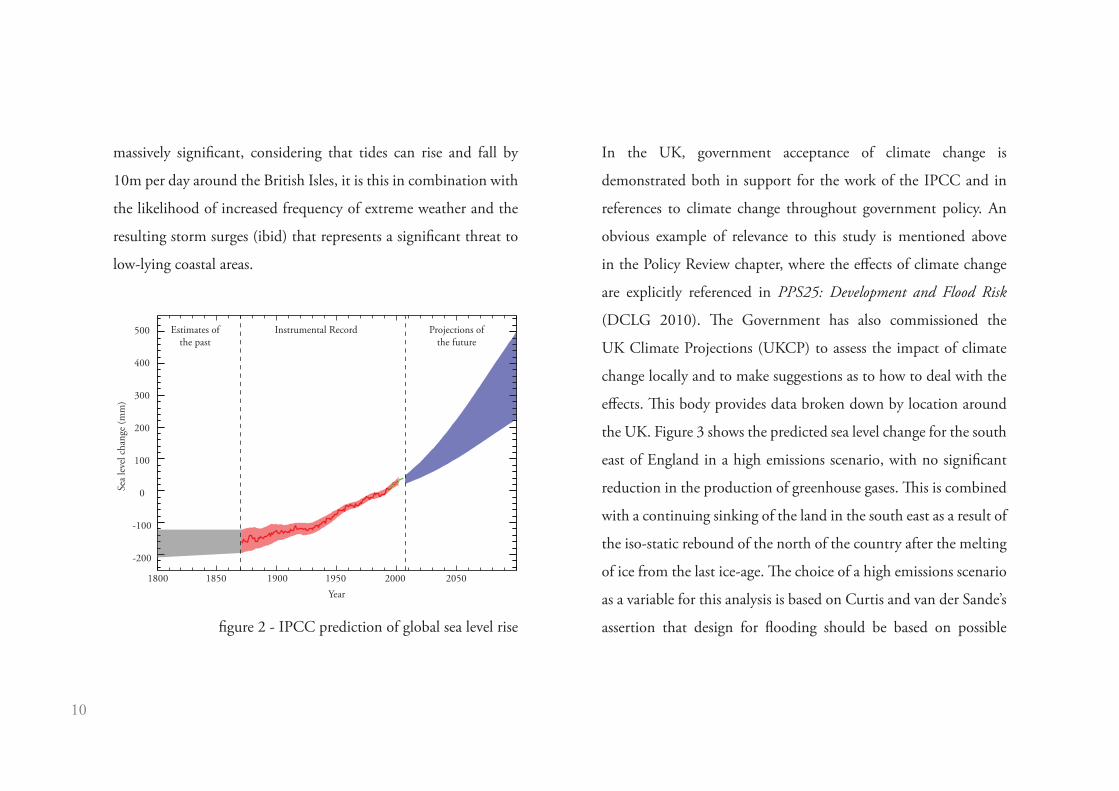
The report then goes on to examine the likely effect of different
emissions scenarios on continued climate change, with the most
extreme scenario, assuming a lack of emissions control leading
to a possible 6.4°C rise in global temperatures and a 0.6m rise
in sea-level by 2100 (ibid p.8) (see figure 2). Evidence for this
being influenced by human activity is shown from archaeological
investigations that have established that sea levels stabilised around
3000 years ago, following the last ice-age and remained stable until
around 1850 (ibid). While a 0.6m rise in sea level does not seem
10
massively significant, considering that tides can rise and fall by
10m per day around the British Isles, it is this in combination with
the likelihood of increased frequency of extreme weather and the
resulting storm surges (ibid) that represents a significant threat to
low-lying coastal areas.
In the UK, government acceptance of climate change is
demonstrated both in support for the work of the IPCC and in
references to climate change throughout government policy. An
obvious example of relevance to this study is mentioned above
in the Policy Review chapter, where the effects of climate change
are explicitly referenced in PPS25: Development and Flood Risk
(DCLG 2010). The Government has also commissioned the
UK Climate Projections (UKCP) to assess the impact of climate
change locally and to make suggestions as to how to deal with the
effects. This body provides data broken down by location around
the UK. Figure 3 shows the predicted sea level change for the south
east of England in a high emissions scenario, with no significant
reduction in the production of greenhouse gases. This is combined
with a continuing sinking of the land in the south east as a result of
the iso-static rebound of the north of the country after the melting
of ice from the last ice-age. The choice of a high emissions scenario
as a variable for this analysis is based on Curtis and van der Sande’s
assertion that design for flooding should be based on possible
1800 1850 1900 1950 2000 2050Year
Estimates ofthe past
Instrumental Record Projections ofthe future
Sea
leve
l cha
nge
(mm
)
500
400
300
200
100
0
-100
-200
figure 2 - IPCC prediction of global sea level rise

11
consequences, rather than the likelihood of them happening, to
avoid a catastrophic event (RIBA 2007 p.24).
This sea leavel rise along with the possibility of another storm surge
similar to the one that struck the east coast of England in 1953 has
the potential to cause water levels in excess of 6.5m above mean sea
level in the Thames Estuary.
It is obvious from this data that there is a clear need to prepare
for the increased likelihood of an event of this kind and that
architecture has a significant role to play in creating a new way of
living with water that minimises the risks of flooding.
The following chapter will examine the literature that has arisen
in this climate of scientific consensus for the acceptance of
anthropogenic climate change and the resulting increase in sea
level and extreme weather events.
0.0m
0.2m
0.4m
0.6m
0.8m
1.0m
5% Certain
50% Certain
95% Certain
212121112101209120812071206120512041203120212011
UKCP09 Relative sea level rise in high emissions scenario:South East United Kingdom
figure 3 - UKCP09 prediction of sea level rise in South East
England

12

13
The academic justification for this study is based on two supporting
and related bodies of work. Firstly, the critical reaction to existing
government policy regarding how we live with water and secondly,
academic and real world suggestions of new ways of living with
water.
Criticism of the government’s approach has come from numerous
directions. Before the most recent large scale floods that hit the
UK in 2007 (see figure 4), White and Howe were convinced that
“current planning policy and practice, albeit unintentionally,
foster[s] an environment susceptible to flooding” (2002, p.743).
They argued that any attempt to improve the situation could
not simply rely on engineering schemes to control floodwater,
but would have to address the “economic, social and political
factors influencing wider society and underpinning the impact of
damaging floods” (ibid, p.744).
Literature Review
figure 4 - Tewkesbury flooded in 2007

14
Another criticism of building larger and more elaborate flood
defences comes from Lewis and Kelman’s paper that investigates the
risk ecology of building housing in areas at risk of flooding. They
argue that “flood defences have so often implied a falsely absolute
protection, under the assumption of which more development has
taken place, leading to greater destruction, damage and casualties
when flooding eventually, inevitably, occurred” (2009, p.16) (see
figure 5). Therefore the existing practise of building in areas at
risk of flooding and then attempting to protect these areas with
massive engineering projects is unsustainable and unrealistic.
This argument is backed up by the UK government’s Foresight
Programme, which examined the challenges of flooding posed by
climate change and “found that if we used engineering alone to
manage the additional risks, it could cost £52 billion of investment.
This compares with £22 billion when using engineering in concert
with a range of non-engineering measures” (Evans & Hall 2004,
p.56).
figure 5 - New Orleans flooded after Hurricane Katrina,
August 2005

15
However, this excessive cost does not mean that simply ignoring
the issue of sea level rise and increased flooding is realistic, in
Adapting Buildings and Cities for Climate Change, the possible
threat is outlined, with a minimum 300mm rise in global sea
levels likely by 2100 in a best case scenario and up to 700mm
if mitigation efforts fail (Roaf et al 2005, p.193). This effect is
compounded in the UK by the continued effects of the last ice
age, 18,000 years ago. This change, known as isostatic rebound
is causing land to fall in the south of England as the north of
the UK rebounds from the removed weight of the ice sheet and
the entire island tilts. This change combined with the effects of
climate change could cause an increase in sea level of 1000mm
by 2100 in the south east of England (ibid). In addition to this,
Roaf also speculates that with increased global temperatures, the
Greenland and Antarctic ice sheets may begin to melt and into
the 22nd century leading to massive increases in sea level of up
to 70m (ibid, p.192) (see figure 6). It is therefore clear that a
solution will need to be found. However, Roaf ’s book, despite its
figure 6 - Great Britain following a 70m rise in sea level

16
title, suggests little in the way of mitigation measures or alternative
approaches beyond vague speculation that “we may then see, over
the next decades, the migrations of populations to less climatically
exposed regions of the British Isles” (ibid, p.204). This assertion is
undermined by evidence given in the same chapter, that London
has suffered from numerous catastrophic floods in its history, most
famously the 1953 flooding that resulted from a storm surge in the
North Sea, shown in figure 7, and yet is still the most populous
city in the UK and forecast to grow further (ibid p.203).
If we accept that population pressure in the south east of the UK is
likely to continue and that this area is the most susceptible to the
various threats resulting from climate change, then it is clear that a
considered approach is necessary. This leads to the LifE project, or
Long-term Initiatives for Flood-risk Environments. This text takes the
threat of climate change and its resultant effects as a given and states
that there are 5 million people in 2 million homes in England and
Wales at risk of flooding (baca architects, 2009, p.3). The report figure 7 - aftermath of 1953 storm surge

17
proposes numerous strategies, applicable to different scenarios, for
dealing with flooding. The strategies are all characterised by being
both long-term and non-defensive and are underpinned by the
concept of “making space for water” and illustrated in figure 8 (ibid,
p.4), an approach suggested by the Department for Rural Affairs
(Defra) which is focused on “managing the risks from flooding [...]
by employing an integrated portfolio of approaches which reflect
both local and national priorities” (ibid). Making space for water
means controlling floodwater and mitigating its effects rather than
simply attempting to hold it at bay. The project proposes solutions
to flooding that attempt to mitigate the threat to both existing
and proposed developments as well as creating opportunities for
additional amenities and energy generation. This text goes much
further than Adapting Buildings and Cities for Climate Change and
takes real-life scenarios that have characteristics that appear across
the British Isles and proposes best practice solutions. This study
will return to the recommendations in the LifE report, but for
now it is most important to note that when considering the issue
of cost, the report suggests that the recommendations made may
incur expenses of up to 30% more than traditional construction
methods. However, this figure does not take into account the
additional cost of flood defences that may be needed or the costs
and time taken to repair any flood damage to developments that
do not make space for water, costs that should be offset by the
money saved after a single flooding event (ibid, p.26).
figure 8 - LifE approach
to rising sea levels and
flooding

18
To focus this study on a single area in order to assess its success
and suitability this study has drawn on the work of the RIBA’s
Building Futures thinktank. This body produced a number of
texts dealing with the issue of flooding and living with water. The
collection of papers, Living with water - Visions of a flooded future,
examines first of all the threat facing the UK from climate change
and its effects and then presents papers from various professionals
working in the built environment. The threat of flooding is broken
down simply into its cost, currently a total of £2.2 billion per year,
made up of £800 million spent on defences and £1.4 billion spent
on repairing damage caused by flooding. The text also draws on
the UK government’s Foresight Project, that has been mentioned
previously, to argue that the cost of damage could rise to £25 billion
in the worst case scenario (RIBA 2007 p.3) and the number of
people in the UK at risk from flooding increase from 1.5 million to
3.5 million as a result of climate change. The introduction to this
text makes a number of statements regarding the ongoing threat of
flooding, of particular relevance to this study is the suggestion that
“Challenges [faced] now and in the coming years may drive us back
towards embracing the previously dynamic relation between land,
water and community” (ibid, p.5)
Visions of a flooded future also presents a quote from Bill Getting,
the RIBA President’s Sustainability Advisor,
Vernacular architecture somewhere in the world is probably already
designed to cope with the extremes of climate we will face - whether
flooding, drought or high winds. We can learn from these precedents
(ibid) (see figure 9).
The combination of these two notions has been particularly
influential on this study. The papers in this text contain a
number of inspiring statements, intended to spur discussion and
innovation, rather than specific solutions - statements specific
to the Thames Estuary - but applicable to any area at risk from
flooding. Kim Wilkie argues that an elemental landscape such as

19
that of the estuary should set the priorities for new architecture
and encourage building forms sympathetic to the location and
tolerant or “even welcoming of water” (ibid, p.11). David Price
presents development in the Thames Estuary as “potentially the
most magical expression of our gradually evolving relationship
between land and water,” (ibid, p.12). In their paper, Paul Ruff
and Glenn Moorley examine two scenarios for development in the
estuary, the first reliant on a massive engineering intervention to
create a new barrage across the mouth of the river and the second a
softer and holistic approach that “gives the opportunity for each of
the areas’ problems to be addressed individually through tailored
solutions (ibid, p.21). They argue that this approach, with its scope
for flexibility, is the more seductive and provides the possibility
of developing a unique identity for the area through innovative
design. Finally, Kiran Curtis and Kees van der Sande challenge
the currently accepted wisdom of designing for probability - the
Environment Agency’s 1 in 100 or 1 in 1000 year flood levels - a
mindset that leaves us at risk of a “[flooding] event that has a low
figure 9 - a vernacular response to a flooded landscape

20
chance of happening, but is catastrophic if it does” (ibid p.24). They
argue that an increased awareness of the risk of flooding amongst
the general public is needed to drive demand for mitigations
measures, an argument that reflects the conclusion of Lewis and
Kelman’s paper mentioned above.
Most relevant to this study is another Building Futures paper, the
2009 text, Facing up to Rising Sea-levels: Retreat, Defend, Attack?
This document takes the standpoint that there is a possibility of
sea-level rise of up to 1960 mm in some parts of the UK (UK
Climate Projections 2009). The problems caused by this sea-level
rise will be felt particularly in densely populated urban areas (RIBA
2009, p.2), ranging from flooding from rainwater, storm-surges
and increased wave damage and coastal erosion. Theses problems
require drastic solutions because the cities affected are important
to the national fabric both in terms of identity and economic
activity, either as ports and trading areas or as tourism draws (ibid
p.4). Therefore simply abandoning these areas and relocating their
populations is not a viable option. This document proposes three
varied approaches towards flood management, emphasising
a long-term strategic approach that provides a framework for
immediate action. These three options, as described in the title
are characterised as retreat, defend and attack and shown in
figure 10. Retreat is intended to be managed and long-term and
involves allowing water into areas that are not economically viable
to defend. This strategy, however, is not necessarily practical
in densely populated areas and does not provide solutions to
other conflicting issues such as population growth and creating
sustainable communities. Defend is the most expensive group of
solutions, and requires a great deal of coordination across large
areas, the high cost means that this strategy is only practical in
Retreat Defend Attack
figure 10 - retreat, defend and attack diagrams

21
extremely high value areas such as the City of London. The final
approach, Attack, is also expensive but involves creating extremely
flexible and dynamic space for cities to expand into, areas that take
advantage of the amenity of waterside locations and could possibly
provide a significant economic return on the cost of investment
(ibid p.10).
Retreat, Defend, Attack? takes a similar approach to the LifE project
in describing the threat posed by climate change and sea-level rise,
proposing different solutions and then applying these to real-life
examples. In addition to these practical proposals, the text draws
three main conclusions that, it is argued, must be met in order to
successfully respond to the threat posed by sea-level rise. The first
conclusion is the original rationale for the thinktank’s work, that
the UK has limited resources and simply cannot afford to protect
the entirety of its coastline, therefore a variety of solutions are
required, solutions that are economically viable and can be shown
to generate an income or balance their costs against savings made
in other areas. Secondly, the report argues that due to the large
scale of the issue, solutions will require a coordinated approach
and strong leadership from a body with a strategic overview that
can communicate the threats and solutions effectively. Finally the
text goes much further than the LifE Project by looking at examples
concerning entire cities and proposing solutions that could provide
practical development options in extremely long term situations,
up to 200 years. This long term approach is presented as necessary
in contrast to the current situation where long term strategic
planning is crippled by the conflicting timescales of the four year
electoral cycle, 10 to 15 year scope of local planning, 20 year
timeframe of infrastructure development and 50 to 100 year, or
longer, scale of change in the climate and coastal environment. The
text proposes that to deal effectively with this, a successful proposal
will need to provide a long term framework for development, but
with the possibility of immediate action (ibid p.26).

22
The literature examined in this chapter combined with the scientific
data described earlier provides the framework and theoretical
underpinnings of government policy in the UK; the next chapter
will examine the current state of this policy and consider its
effectiveness.

23
In order to explain the architectural response to flooding in the
UK, this chapter will provide an overview of government policy as
it applies to flooding and development. Development policy in the
main is controlled by the Town and Country Planning system, this
system is comprised of a body of national policy that then informs
regional policy and finally plan making, objective setting and
decision making at a local level. Government policy therefore has
an indirect influence over all development taking place in locations
affected by flooding across the UK.
National planning policy is framed in overarching terms by
Planning Policy Statement (PPS) 1, Delivering Sustainable
Development (DCLG 2005), which sets out a set of objectives
that need to be “taken into account by regional planning bodies
[…], the Mayor of London […] and local planning authorities
in the preparation of local development documents (p. iii DCLG
2005). PPS1 makes “sustainable development the core principle
Policy Reviewunderpinning planning” (p.2 ibid) and bases this principle on the
classic definition given by the Brundtland Report:
“Sustainable development is development that meets the needs of the
present without compromising the ability of future generations to meet
their own needs” (Brundtland 1987).
In terms of flooding PPS1 states that local planning authorities
should consider :
“the potential impact of the environment on proposed developments
by avoiding new development in areas at risk of flooding and sea-level
rise, and as far as possible, by accommodating natural hazards and the
impacts of climate change” (DCLG 2005 p.8)
Planning authorities also have a responsibility to prepare robust
policy that are based on objectives for the future of the area,
objectives that should include ensuring that developments “are

24
sustainable, durable and adaptable (including taking account of
natural hazards such as flooding) and make efficient and prudent
use of resources” (p.14 ibid).
PPS1 influences all other planning policy, which when looking
specifically at flooding is controlled by PPS25, Development
and Flood Risk (DCLG 2010) which sets out the framework for
national policy on flooding and again outlines the objectives that
regional planning bodies, the Mayor of London and local planning
authorities must consider when preparing local development
documents.
PPS25 accepts that flooding is a natural, unavoidable process and
that we have to concentrate on management and reducing its
effects. PPS25 also describes the Government’s belief that climate
change is likely to mean “milder wetter winters and hotter drier
summers in the UK, while sea levels will continue to rise” (DCLG
2010 p.1) which will cause both an increased flooding where this is
already experienced and entirely new risks where flooding has not
occurred in the past. The aim of planning should be to “appraise,
manage and reduce this risk” (p.2 ibid) where possible.
To achieve this, PPS25 describes a risk based approach whereby
local planning authorities are required to deal with three factors,
firstly the source of flood risk, by reducing development in flood
risk areas and minimising run-off from new development. Secondly,
the pathways of floodwater, by managing the routes taken by flood
water and managing unavoidable run-off. Finally, the receptors of
floodwater, reducing the impact on anything affected by floods,
from people to property (p.6 ibid).
PPS25 insists that all applications for development within areas at
risk of flooding, designated by the Environment Agency, must be
accompanied by a flood risk assessment. This document, prepared
by the developer, must demonstrate the effect of flooding on the
proposed development, prove that the development is safe, will
25
not cause increased flooding elsewhere, reduces flood risk overall if
possible, and describe any measures proposed to combat flooding
(p.8 ibid). This assessment is then judged by the Environment
Agency and local authorities should take their verdict into account
when determining applications.
As an example of how this policy is interpreted by local authorities,
this study has also examined the proposed Core Strategy of
Dartford Borough Council. This council covers an area on the
south bank of the Thames Estuary, to the east of London and its
core strategy is the central planning document that will outline the
framework and objectives for development in the borough over
the next 10 to 15 years. It highlights the challenges facing the UK
in accommodating housing demand in the south east and dealing
with flooding, while PPS25 insists that development should be
avoided in flood risk areas, the Dartford Core Strategy, influenced
by other government objectives, states that 11,700 new homes
should be built in the Thames waterfront area (Dartford Borough
Council 2011 p. 44). The document also demonstrates a lack of
imagination when dealing with flooding, despite the current risk
and likely future increase, the Core Strategy simply refers back
to policies set out in PPS25 to require flood risk assessments and
the implementation of Sustainable Drainage Strategies (SUDS)
(p.85 ibid). The only local originality is a stated aim to safeguard
green infrastructure and make provision for water bodies in new
development (p.86 ibid).
The shortcomings in this document highlight the discrepancy
between the integrated approach described as absolutely necessary
in reports such as LifE in previous chapters and also required in
national policy and the reality of local planning today. It is in this
gap between recommendations and actual policy that this study
argues there is space for a new, integrated and ambitious approach
to living with water.

26
The preceding chapters demonstrate that there is not only a sci-
entific consensus that climate change is happening and will have
long lasting and dramatic effects but also a multitude of theoreti-
cal responses suggested and a political will to implement them.
However, in the UK development of any kind that responds
specifically to water in an innovative way is scarce and most likely
to take the form of houses with uninhabited ground floors, see
figure 11, a typology that creates a streetscape devoid of life and
seems an inappropriate response to a threat of flooding that could
become much more frequent, or even a permanent state of inun-
dation.
The following chapter investigates and analyses case studies from
around the world that take the challenge of flooding and rising
sea levels and use this constraint as an inspiration to create ways
of living with water that are new to the UK or implemented only
on a very small scale.
figure 11 - typical flood resilient houses in the UK

27
There is a massive variety of examples of the potential for
architecture to offer a new perspective on our attitude to water and
how to live with it. This study will examine these examples under
four categories, categories that will occasionally overlap but should
remain fairly distinct. Firstly, there is vernacular architecture,
or rather, structures created purely to deal with practical issues
of water encroaching onto land occupied by humans. These
structures have existed throughout human history and across
the planet, this study will examine various examples of these and
suggest building methods and typologies that could be adapted
to deal with contemporary issues. Secondly, twentieth century
examples, designs from the post-industrial revolution era that have
sort to address living with water, whether through necessity or
simply for effect. This period is particularly interesting due to the
application of different technologies that emerged, from building
with reinforced concrete to the high-technology building solutions
that emerged in the latter part of the century. The third category
is that of contemporary examples, with the growing recognition
of the issue of climate change and its effects, new approaches
have been taken to living with water, from prosaic examples of
resilient buildings in the UK that employ raised floor levels and
materials that can be easily cleaned to housing developments in the
Netherlands that have combined facets of that country’s houseboat
tradition with modern housing types to create floating estates that
can adapt to changing conditions. The final category under which
the case studies will be examined is that of speculative projects. As
mentioned before, the issue of climate change has been steadily
increasing in importance and recognition, this has resulted in a
rash of speculative architectural solutions to the problems caused,
from the adaptation of existing water-borne infrastructure to the
repurposing of entire cities once they become flooded. This chapter
will deal with these categories in turn and offer examples, analysis
and suggest features from each that could be adopted in an attempt
to find a new way to live with water.
Case Studies

28
Vernacular
When considering vernacular building types that respond to
flooding, the most obvious example is that of the stilt house. These
buildings are found around the world from Palafito houses in
Venezuela and Chile to Nipa huts and Pang uks in the Philippines
and Thailand to Crannogs in Scotland and Ireland (figure 12).
These buildings all share common locations, areas of large bodies
of water such as coasts, lakes and deltas, where the inhabitants lived
intimately with the water, often in subsistence lifestyles, using the
water to supply food and as a means of transport. As a result of this
lifestyle the buildings require minimal infrastructure, there is no
need for roads and modern day stilt houses in South East Asia often
still have no access to services such as running water and electricity.
They use local materials for construction - bamboo in Asia, timber
or stone in Scotland and timber in South America - and are very
flexible and adaptable in construction, easily extended, dismantled figure 12 - Palafito houses in Chile

29
or raised depending on local conditions such as weather or food
supplies. They also serve additional uses, such as in South East
Asia, providing space for building where the expanses of water
makes traditional construction impossible and land too valuable
for agricultural use to build on. In Scotland, island dwellings gave
protection and in South America provided space for living in areas
next to rivers, the major transport routes.
Stilt dwellings fill many of the criteria set out by the various texts
in the Literature Review chapter. In areas where various social,
economic and political factors have combined to induce people
to live, despite the risks of flooding (White & Howe 2002), they
provide reasonably safe accommodation for their inhabitants.
They are also much cheaper to build than the massive engineering
projects that would be needed to protect vast areas such as river
deltas from flooding and due to the nature of their construction
and the lifestyles of the people that inhabit them, they help to
prevent the false sense of safety and security that Lewis & Kelman
(2009) argue is responsible for the extremely high costs of damage
from flooding in areas that rely on defences. As an extension to this,
the close relationship that the buildings foster with water means
that the inhabitants are very sensitive to changes in climate and its
impacts and are likely to be much more aware of the consequences
of human activity on their lifestyles and therefore more likely to
be willing to make changes and adapt to prevent or mitigate such
consequences. Stilt houses also represent an architectural style that
responds particularly successfully to its environment, occupying
locations that take advantage of natural shelter, exploit resources
in a sustainable way and helping to create unique identities for
the areas in which they are built, all characteristics that Living
with water insists must be a part of new developments in flood-
prone areas in the UK (RIBA 2007). However, where vernacular
stilt houses fall down as examples of appropriate development
that could be adopted in the UK is in two key issues raised in
Retreat, defend, attack, specifically that for development to respond
to flooding on a large scale and offer a successful alternative, it

30
would need to be coordinated, strategically planned and very long-
term (RIBA 2009). In contrast to this the silt houses discussed
here are developed on a small scale, individuals responding to
specific conditions and constraints, using materials that are light
and easy to work but with fundamentally short life spans. While
this produces architecture incredibly well adapted to its location,
it does not necessarily provide a solution that can be adopted on
a large scale. However more modern developments have adapted
this typology, particularly in the South-eastern United States where
frequent hurricanes and a coordinated effort by the insurance
industry has created the Fortified...for safer living programme, this
specifies stilt houses, with living areas located above catastrophic
storm surge levels with decks and storage designed to breakaway
below. Figure 13 shows the a group of fortified homes, left standing
after Hurricane Ike hit Texas, amid the rubble of traditionally built
homes. This emphasises the success of this design (figure 14) and of
the importance of designing to possible consequences as opposed
to weighing up the probability of risks (RIBA 2007).
figure 13 - surviving fortified houses in Texas folowing
Hurricane Ike in in 2008

31
It is clear that the stilt house typology offers numerous advantages
that could be adopted and adapted in contemporary housing
to address the threat posed by climate change, sea level rise and
flooding and create a new way of living with water. However, new
challenges would also be created, how to supply and safeguard
services to housing that could often be surrounded by water or
threatened by storm surges.
Another, more extreme, vernacular approach to living with water,
is that of the nomadic populations of South East Asia, such as
the Badjao people of the Philippines and the Moken in Thailand
and Burma. These people live an even more transient existence
than those inhabiting stilt houses, their lives mainly conducted on
boats and often existing outside of constructed ideas of nationality
and property (figure 15). They rely on subsistence fishing and
small amounts of trading and visit land rarely. It is difficult to
appraise this lifestyle in an architectural sense, however, there are
facets of it that could be adapted to the UK, provided support
networks and infrastructure were provided to enable people to
live conveniently and hygienically on boats. The mobile nature of
their accommodation means that the nomadic people are able to
move entirely at will, to areas with better food supplies or to avoid
conflict. If sea levels did eventually rise to the extremes suggested
by Roaf (2005) then the scope for boats as both accommodation
and travel could increase massively in the UK and this could
rigid structure to resist wind and wave action
platform above predicted storm surge level
stairs and decks designed to break away
rigid piles strong enough to resist �oating debris
rigid piles sunk deep into solid ground
predicted storm surge
figure 14 - fortified house design

32
be adapted to moving to find employment, or improved living
conditions and not being restricted by ownership of a solid,
immovable building and the vagaries of the housing market. This
way of life also corresponds with the suggestions in the Living with
water paper, that solutions should address problems individually
and develop uniquely to specific areas. In the UK areas that are
already extremely low lying such as the Norfolk Broads and other
spaces that have been reclaimed from the sea, could be retreated
from and turned over instead to roving populations of boat people.
For this to succeed, again the assertion in the Retreat… report
(RIBA 2009) is key, that a long term, coordinated approach would
be needed to provide appropriate infrastructure.
figure 15 - Badjao people in the Phillipines

33
20th Century
The first 20th century case study chosen is not a development
that was intended to deal with flooding, but rather one that had
to approach water in a different way, driven by economic forces
to exploit resources. This is Neft Daslari or Oil Rocks, an oil
production facility on the Caspian Sea in Azerbaijan. Originally
built by the Soviets, construction started in 1949 and the complex
is still partially operational, with investment attracted by the
Azerbaijani government leading to new additions being added to
the original structure.
The complex itself is comprised of around 600 oil wells strung out
into the Caspian Sea, linked by 120 miles of trestle pathways to
each other and back to larger man-made islands (figure 16). The
original construction was built 34 miles offshore on piles using
sunken ships as foundations and as the complex grew larger the
islands were extended with earth and landfill. The islands now figure 16 - Oil Rocks
aerial view

34
support shops, hotels, cinemas and a Palace of Culture to occupy
the 5000 oil workers that spend week long shifts offshore.
Although Oil Rocks was not designed to respond to changing water
levels but rather the permanent presence of water (figure 17), it
does demonstrate a further development of the kind of technology
used in stilt houses mentioned above to create settlements that
exploit water while also making space for it (baca architects 2009).
It does this in a way that is permanent yet flexible and cheaper
than attempting to drain or protect a similar area from the water.
It also shows how an extremely coordinated response, with strong
leadership as suggested by the RIBA’s Retreat… report (2009),
can create very large engineering and development schemes,
although this highlights how difficult it may be to achieve similar
developments in the UK if it requires coordination on the level of
a communist dictatorship.
figure 17 - Oil Rocks road network

35
By developing the idea of Oil Rocks further, it is also possible to
see how this kind of development could meet many of the other
requirements from the various papers examined in the Literature
Review. Building housing on stilts out onto the water reduces
pressure on the land both in terms of space for housing and space
for water in times of flood, therefore, areas up- or down-stream or
further along the coast will not suffer increased flooding as space
has been left for water (baca architects 2009). Living over water
would also give the inhabitants a better perspective over the active
climate and river systems and make them more aware of changes,
their own impacts and the threat of flooding - helping to counter
the false sense of safety described by Lewis & Kelman (2009). A
large framework like Oil Rocks would also provide opportunities
for siting renewable power generation facilities as described in
the LifE Report, so a development could mitigate the effects of
climate change in multiple ways (baca architects 2009). Finally if
a development such as Oil Rocks was designed around a modular
framework it could be made flexible and dynamic, responding to
changing economic or climatic conditions, population change
or resource availability, growing in size to respond to demand or
changing shape to adapt to changing river or coastal morphology
in the manner recommended in the RIBA’s Retreat… (2009).
A second 20th century example of living with water is that of the
urban house-boat. These craft are found across the world and vary
in execution on a spectrum from boats that can be lived on to
houses that float. They can also vary in scale from units that would
provide enough space for one or two people up to massive floatels,
used in the offshore oil industry that provide accommodation for
around 500 people in safety and comfort in harsh locations such
as the North Sea (figure 18). One notable characteristic of smaller
houseboats is that they are often found in the harbour areas of
post-industrial cities, occupying waterfronts that no longer serve
any practical purpose. In these locations, colonisation by house-
boats frequently takes place before redevelopment of the former
industrial areas has gathered pace and the homes exist in a semi-

36

37
legal status, re-using obsolete docks and often converting boats
discarded by the post-industrial society. These house-boats also
have varied requirements; those such as the narrow boats found on
British canals are relatively self sufficient, generate their own power
and only require occasional facilities to fill up water tanks and
empty chemical toilets (figure 19). These house-boats represent
the ultimately flexible solution to living with water and are able
to move in response to economic or climatic conditions and settle
wherever there is space. In contrast, house-boats in places such as
Vancouver and Denmark are much more floating houses, requiring
permanent moorings and connections to services in order to
survive. These craft often have no form of propulsion, only moving
once in their existence, from shipyard to berth (figure 20).
As a solution to the threat of flooding, a mixture of these types of
house-boat seems appropriate - smaller, more self sufficient craft
could move around, providing accommodation where economic,
political or social reasons have created a demand for people to live,
preceding page - figure 18 - Floatel Superior in a Norwegian fjord
figure 19 - mobile houseboat in Amsterdam

38
able to exist regardless of flood risk (White & Howe 2002). More
permanent craft would be more suitable in areas where population
is more stable, but pressures from flooding are extreme enough to
require a solution more flexible and dynamic than stilt buildings.
House-boats of any kind would be adaptable to all consequences
of climate change and sea level rise, fulfilling Living with water’s
requirement that solutions accommodate possible consequences,
rather than judging their likelihood of occurring (RIBA 2007).
Furthermore they are the only accommodation that could cope
with the extreme sea level rise forecast by Roaf et al, were the polar
ice caps to melt (2005). House-boats would also seem to address
Lewis & Kelman’s (2009) concerns about false ideas of protection,
as inhabitants of houseboats would have the same relationship
to water as the nomadic south east Asian communities discussed
above, aware of every change in their environment and the effect
of human activity upon it. A criticism of houseboats may be that
they do not really create the unique architectural identity of an
area suggested in Living with water (2007), rather seeming to result figure 20 - stationary houseboats in Vancouver

39
in entirely individual approaches and solutions, although this
haphazard nature could be argued to be of more character than
uniform housing estates currently being built in Britain. A final
positive feature of house-boats is that due to their individualistic
nature, they would not require the same degree of leadership
and coordination demanded by the RIBA’s Retreat… (2009) and
therefore, may be more appropriate as an immediate solution,
prior to the establishment of longer term frameworks.

40
Contemporary
A very recent case study for architecture that responds to the
challenge of living with water is Architectenbureau Marlies
Rohmer’s Steigereiland development in Amsterdam (figure 21).
This development is being built in the Ijmeer to the east of
Amsterdam, on one of a series of new islands forming an urban
extension to the city, known as Ijburg. Ijburg is an archipelago of
seven islands constructed from dredged sand and intended to be
occupied, once completed, by 45,000 people and provide 12,000
jobs. The island extension was originally proposed in the 1960s
but plans were shelved until the 1990s when population pressures
in Amsterdam forced a reassessment of the city’s expansion. The
islands are bisected by both a main road and a tramline that
connects them to the city as well as a number of pedestrian and
bicycle bridges.
resilient lower �oor uses
stilt buildings�oating houses alongside pontoons
arti�cial island
road and tramway
figure 21 - Steigereiland site plan

41
Steigereiland itself is the first island in the chain and closest to
the centre of Amsterdam. Rohmer’s scheme lies partially on this
artificial island and partially floats in an area surrounded by
dykes to the north of the transport spine (figure 22). The scheme
comprises a mix of both programmes from houses to apartments,
offices and shops and a mix of water-tolerant typologies (figure
23). Uses that are more resilient to flooding, shops and offices, are
resilient lower�oor uses - shop etc
arti�cial island
protected escape route
stilt buildings - housing above shops
�oating houses on concrete pontoons
jetties
figure 23 - Steigereiland typologies
figure 22 - floating houses at Steigereiland

42
located on the ground floor of buildings that line the perimeter
of the site, with apartments above. On the shoreline, more
apartments that blur the edge of the dry land extend out over the
water on stilts. Finally housing units, individual homes, attached
dwellings and more apartments, constructed in timber, float on
concrete rafts, attached to jetties and bridges that stretch out into
an enclosed area of the Ijmeer, able to move up and down on steel
piles in response to changing water levels. The floating houses were
constructed in a shipyard and towed to site, they have no means of
propulsion and are intended to remain in-situ, fostering a sense of
permanence to counteract their vertically mobile nature and avoid
the nature of a transient community. The intention has been to
create a scheme that will appear as an addition to the city and
function as a community There is no attempt to foster a sense of
detachment from the rest of the city and the buildings are mixed
to create “a pleasantly varied character” (Rohmer in Architecture
Today 214, January 2011). Chris Foges argues in Architecture Today
that this sense of relationship to the rest of the city is what makes
the scheme successful, that there is no sense of isolation and that it
is “the foundation of the city, its social and technical organisation,
that make the project possible.” (Architecture Today, p.17). Foges
also points out that another factor, crucial in the success of the
project, is a perceived national consensus in the Netherlands to
work collectively to combat the problems of living with water
and achieve the incredibly high level of coordination for such a
complex project to succeed (ibid). For a scheme of this type to
succeed in the UK it may be questionable whether such a high
level of coordination can be achieved, this relates back to the
argument presented in the RIBA’s Retreat... that a coordinating
body is needed in the UK to successfully respond to the threats of
climate change (RIBA 2009, p.26).
On a much smaller scale, another example of architecture that
deals with flood risk is the Salt House by Alison Brooks Architects
(RIBA Journal November 2005). Completed in 2005, this house
is situated on the Essex coast in an area at significant risk of

43
flooding from the sea. This building is an example of an approach
that combines both short and long term measures to combat the
threat of flooding. In the short term the building is designed to be
resilient to flood waters; electrical supplies are brought down from
the first floor to supply the ground floor, doors are designed to
be fitted with extra panels to hold back the water and the sewage
system is designed to prevent waste flowing back into the house. As
a long-term strategy the building was constructed 500mm above
the current flood risk level, a level lower than that recommended
by the Environment Agency (EA).
This was agreed due to the floating pile method of construction
that has been used. The house is constructed as a steel portal frame
sitting on a ground floor slab, which was cast on top of the piles
and a bed of solid foam, which was then removed to leave the slab
suspended. In the event of a long term rise in sea level the piles
supporting the house can be cut and the entire building can be
jacked up to a higher level and additional caps added to the piles
to support this new level (figure 24). The building is designed to
allow flood waters to flow beneath it and remain occupied during
short periods of flooding.
On an individual level this design seems to meet the EA’s
requirements to defend against future flood risk. However, as an
example that could be adopted on a widespread scale, the notion
of jacking up the entire building is impractical, indeed in the
article it is mentioned that although the EA approved the flood
management strategy for the house, they did note that although
the house met current requirements, they believed that in the event
piles cut house jacked up caps added to piles
figure 24 - Salt House lifting method

44
of a breach of the sea wall, it would be impossible to lift the house
in time to avoid the rising water level. While obviously an example
of intriguing house design (figure 25) - the building having been
awarded the RIBA Manser Medal for the best one-off house (RIBA
Online) - it is also an example of innovative methods being used
to deal with the letter of the law regarding flood protection, rather
than a practical solution.
The reality of this project highlights the need for a powerful body
to coordinate and control development in areas at risk of flooding
to avoid this kind of solution that on the surface appears to be
acceptable but fails to deal with the threats outlined in the earlier
chapters.
figure 25 - Alison Brooks’ Salt House

45
Speculative
The rising awareness and public and political interest in climate
change and its resultant effects has spawned a massive variety of
speculative projects that attempt to look at possible future scenarios
and sometimes suggest solutions.
One branch of these projects is a series of fantastical images
produced by Studio Linfors, Squint Opera and for the London
Futures exhibition which show the results of extreme climate
change on familiar landmarks around the world where New York’s
Times Square is re-imagined as a Venetian landscape, St Paul’s is
transformed into a natural swimming pool and people fish outside
London churches (figures 26 & 27). These images, although highly
unrealistic, are useful in provoking thought about the possibility
of significant changes coming about as a result of climate change
- another way of overcoming the false security described by Lewis
and Kelman (2009). Hopefully these images will encourage people
figure 26 - Studio Linfors’ image of a flooded Times Square

46
to imagine solutions to problems that we may be facing, but are
also valuable in proposing positive views of future adaptation
rather than viewing the changes as disastrous.
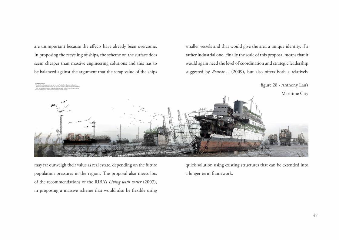
One project that has more of a practical application is Anthony Lau’s
masters project for a new maritime city within the Thames Estuary
(figure 28), this project suggests using redundant oil industry
infrastructure and obsolete ships to create a new floating city within
the estuary. This proposal would site new living accommodation
where demand is greatest, meeting economic and social issues
as White and Howe (2002) demand. It would also satisfy Lewis
and Kelman’s (2009) concern that major engineering projects
give people a false sense of security about the threat of flooding
by exposing the inhabitants constantly to the water. However, the
solution is so extreme and large in scale that it risks creating a
new false sense of security, that threats from climate change are
inconsequential due to the massive new floating infrastructure
created and therefore efforts to mitigate greenhouse gas emissions
figure 27 - Squint Opera’s image of fishing
at St Mary Woolnoth in London
47
are unimportant because the effects have already been overcome.
In proposing the recycling of ships, the scheme on the surface does
seem cheaper than massive engineering solutions and this has to
be balanced against the argument that the scrap value of the ships
may far outweigh their value as real estate, depending on the future
population pressures in the region. The proposal also meets lots
of the recommendations of the RIBA’s Living with water (2007),
in proposing a massive scheme that would also be flexible using
smaller vessels and that would give the area a unique identity, if a
rather industrial one. Finally the scale of this proposal means that it
would again need the level of coordination and strategic leadership
suggested by Retreat… (2009), but also offers both a relatively
quick solution using existing structures that can be extended into
a longer term framework.
figure 28 - Anthony Lau’s
Maritime City
48
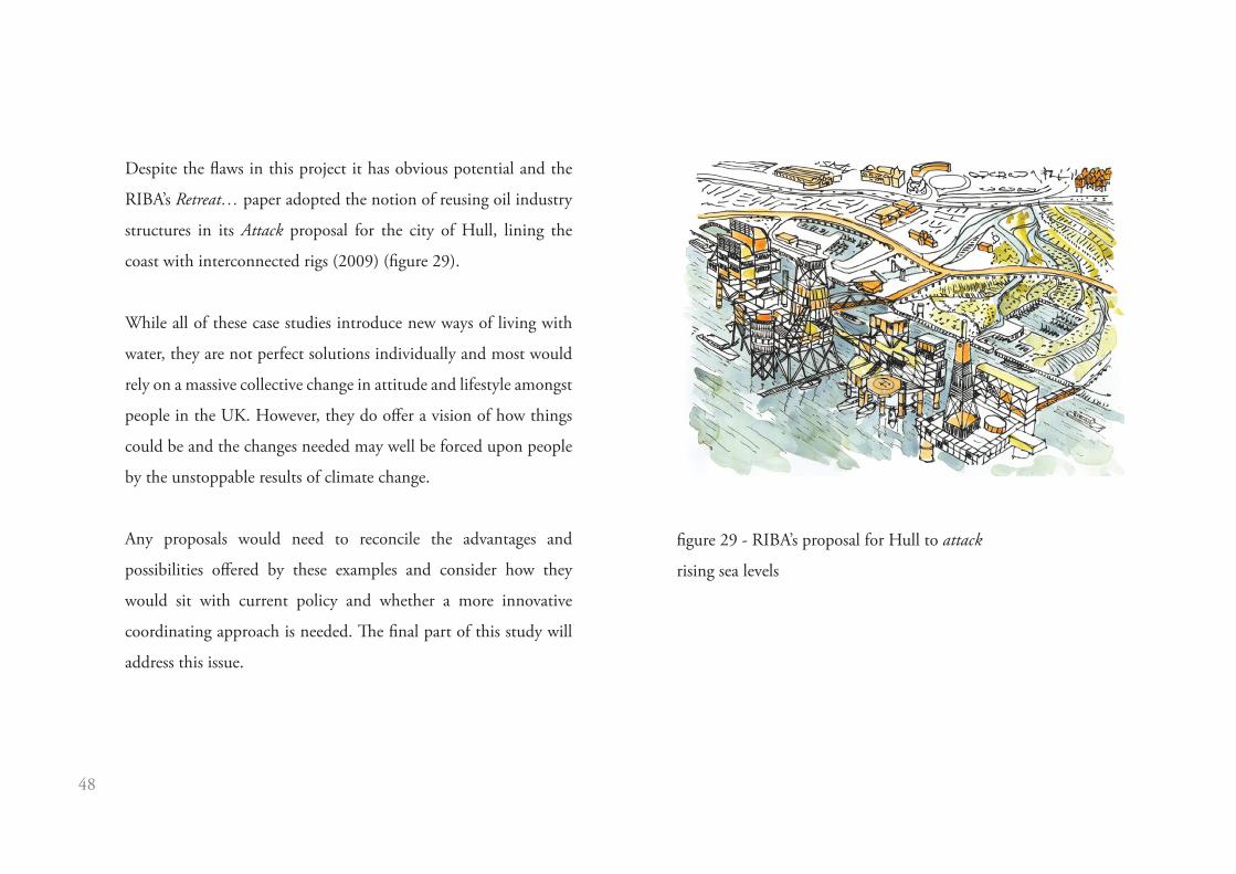
Despite the flaws in this project it has obvious potential and the
RIBA’s Retreat… paper adopted the notion of reusing oil industry
structures in its Attack proposal for the city of Hull, lining the
coast with interconnected rigs (2009) (figure 29).
While all of these case studies introduce new ways of living with
water, they are not perfect solutions individually and most would
rely on a massive collective change in attitude and lifestyle amongst
people in the UK. However, they do offer a vision of how things
could be and the changes needed may well be forced upon people
by the unstoppable results of climate change.
Any proposals would need to reconcile the advantages and
possibilities offered by these examples and consider how they
would sit with current policy and whether a more innovative
coordinating approach is needed. The final part of this study will
address this issue.
figure 29 - RIBA’s proposal for Hull to attack
rising sea levels

49
Our current attitude to the threat of flooding regards it as
an infrequent danger throughout the world. During normal
conditions water seems a harmless element, flowing smoothly
through river channels and lapping gently against the sea-shore.
The severity of flooding events is balanced out by their perceived
rarity. A flood may be catastrophic, but it occurs so irregularly that
our response to it is characterised by frantic activity to deal with
the immediate threat, followed by a gentle slide into disinterest
and public apathy, except among those directly affected and busy
rebuilding their homes and lives.
In the process of researching for this study it became clear that
in the UK there was a flurry of activity immediately after the
2007 floods, culminating in the Pitt Review (2007) and the
various reports and speculative documents produced by the RIBA.
However, since then, attention has shifted away from the threat of
flooding, even as global temperatures have crept upwards and sea
levels have continued their inexorable rise.
It is obvious that this sea level rise still presents a massive threat
to property and lives, particularly in the South East and that this
rise will change the way flooding happens. Over time, rather
than being an irregular event, measured in 100 or even 1000 year
instances, flooding will become a seasonal and then a constant
occurrence. In fact, considering it as flooding, merely a temporary
state of inundation, will become unreasonable; rather the land will
be claimed by the sea, permanently changing the shape of the UK’s
coastline and leading to long-lasting changes in where and how
people live.
From the literature and policy review it can be seen that there is
a slowly emerging consensus, framed by the notion that we need
both short term action and a long term framework to deal with
the more drastic possible changes that we face. However, no single
player has yet taken responsibility for establishing this framework,
planning departments and the Environment Agency disagree over
who is ultimately responsible for building in flooding threatened
Conclusion

50
areas and no overarching body exists. As the pressure exerted by
sea level rise grows greater each year, it will also start to have more
strategic impacts on the UK, as demand for farm land begins to
conflict with population pressures, particularly in the South-east
as more intense, but less sustained rainfall and higher extraction
for drinking water continues to impact on the productivity of
farmland.
The case studies described and analysed above show that there are
established and speculative proposals for both dealing with the
threat of flooding and the damage it causes to property and at the
same time creating more space for living that does not take up
valuable agricultural land. There is a potential for architecture to
contribute to a re-imagining of our entire relationship with water.
There is an opportunity for us to change our attitude, to learn to
live with water and to welcome it. To enjoy its proximity through
new forms of architecture that are not threatened by floodwater and
to exploit its potential to generate power and provide enjoyment
rather than danger. In taking this new approach we could manage
to both mitigate the effects of climate change and its causes, living
more sustainably in a changed environment.
Rohmer’s scheme for Ijburg in the Netherlands is the most
comprehensive example of this, that project provides flexible living
space, protected from rising sea levels and manages to create all
of this without occupying any additional land. In the UK this
model could be implemented in many of the larger towns and
cities, the majority of which are situated in coastal or river-side
locations (figure 30). However, to achieve this the most important
factor is a collective political will to create a strategic overarching
body that could mediate between different stakeholders such as
planning departments and the Environment Agency and provide
the positive environment and coordination that developers would
require to be willing to invest in schemes as innovative as Rohmer’s.

51
It is this need for a coordinated and strategic approach that is the
most fundamental issue to the success or failure of our adaptation to
climate change. Further study needs to go beyond the technological
and architectural solutions, which have been demonstrated to exist,
and examine the underlying structural issues and investigate White
and Howe’s (2002) economic, social and political reasons for why
people are willing to live in flood threatened areas. At present,
development in areas such as the Thames Gateway, a place at
significant threat from sea level rise, seems more of an experiment
into what happens when thousands of people decide to live in a
volatile river environment. Another opportunity for future study
would be to investigate whether specific locations in areas like the
Thames Estuary could accommodate schemes like Rohmer’s and
demonstrate that any additional costs in construction could be
outweighed in the long term by increased flood resistance and the
value of any land preserved elsewhere for more productive uses.

52
following page - figure 30 - a scheme taking advantage of the
flooded centre of Bristol

53

54
55
baca architects. (2009) The LiFE Report. London: BRE Press.
Ballard, J. G. (1962) The Drowned World. London: Harper Collins.
Brundtland, G. H. (chair) (1987) Our common future by the World Commission on Environment and Development. Oxford: Oxford University
Press
Cabinet Office (2007) The Pitt Review: Lessons learned from the 2007 floods. London: The Stationery Office.
Dartford Borough Council (2011) Dartford’s Core Strategy – Preferred Policy Approaches Document. London: Dartford Borough Council.
DCLG (2005) Planning Policy Statement 1: Delivering Sustainable Development. London: The Stationery Office
DCLG (2010) Planning Policy Statement 25: Development and Flood Risk. London: The Stationery Office
Evans, E. Hall, J. A new climate for flood planning. Ingenia 2004, (21), 51-56.
Foges, C. (2011) Liquid Assets. Architecture Today. (214), 12-17.
References
56
Hooimeijer, F. Et al (eds). (2009) Atlas of Dutch Water Cities. 2nd Edition. Amsterdam: Sun.
IPCC. (2011) Organisation [online]. Available from: http://www.ipcc.ch/organization/organization.shtml. [Accessed 3rd April 2011].
Kucharek, J-C. (2005) Salt and vinegar. RIBA journal. 112 (11), 55-62.
Lewis, J & Kelman, I. (2009) Housing, Flooding and Risk Ecology. Journal of Architectural and Planning Research. 26 (1), 14-29.
London Assembly Environment Committee (2005) London under threat? Flooding risk in the Thames Gateway. London: Greater London
Authority.
Pachauri, R.K. and Reisinger, A. (Eds.) (2007) Contribution of Working Groups I, II and III to the Fourth Assessment Report of the
Intergovernmental Panel on Climate Change. Geneva: IPCC.
RIBA. (2007) Salt House wins RIBA prize for the UKs best architect-designed home [online]. Available from: http://www.architecture.com/
NewsAndPress/News/AwardsNews/Press/2007/Salt%20House%20wins%20RIBA%20prize%20for%20the%20UKs%20.aspx. [Accessed 3rd
April 2011].

57
RIBA (2007) Building Futures: Living With Water. London: RIBA.
RIBA (2009) Facing up to rising sea levels: Retreat? Defend? Attack? London: RIBA.
Roaf, S. (2005) Adapting buildings and cities for climate change : a 21st century survival guide. Oxford: Architectural Press
Stern, N. H. (2006) The economics of climate change: the Stern review. Cambridge: Cambridge University Press.
UK Climate Projections. (2009) South East England [online]. Available from: http://ukclimateprojections.defra.gov.uk/content/view/379/499/.
[Accessed 3rd April 2011].
White, I. & Howe, J. (2002) ‘Flooding and the Role of Planning in England and Wales: A Critical Review’, Journal of Environmental Planning
and Management, 45: 5, 735 — 745

58

59
Figures
The centre of Bristol flooded
IPCC prediction of global sea level rise
UKCP09 prediction of sea level rise in S.E. England
Tewkesbury flooded in 2007
New Orleans flooded
Great Britain following a 70m rise in sea level
Aftermath of 1953 storm surge
LifE approach to rising sea levels and flooding
Vernacular response to a flooded landscape
Retreat, defend and attack diagrams
Typical flood resilient houses in the UK
Palafito houses in Chile
Surviving fortified houses in Texas
Fortified house design
Badjao people in the Phillipines
Oil Rocks aerial view
Figure CreditsCredits
Bing Maps and author’s work
Fourth Assessment Report of the Intergovernmental Panel on Climate Change
UK Climate Projections
http://img.thesun.co.uk/multimedia/archive/00347/F_200707_July27ed__i347175a.jpg
http://upload.wikimedia.org/wikipedia/commons/9/9f/KatrinaNewOrleansFlooded.jpg
Google Maps and author’s work
http://upload.wikimedia.org/wikipedia/commons/9/9d/Watersnoodramp_1953.gif
LifE Report
https://picasaweb.google.com/lh/photo/Onli-nOQRFqEpNr_6gLxhA
Facing up to rising sea levels: Retreat? Defend? Attack?
http://images.portalimages.com/large/tp/92053/1591/ecimage1/527542.jpg
http://www.flickr.com/photos/bekahlp/1233160492/
http://www.texasgulfcoastonline.com/Portals/0/GilchristFortifiedHomesHoldUptoIke.jpg
Author’s work
http://www.flickr.com/photos/diamonds_in_the_soles_of_her_shoes/4793301692/sizes/o/in/photos/
Google Maps

60
Oil Rocks road network
Floatel Superior in a Norwegian fjord
Mobile houseboat in Amsterdam
Stationary houseboats in Vancouver
Steigereiland site plan
Floating houses at Steigereiland figure
Steigereiland typologies
Salt House lifting method
Alison Brooks’ Salt House
Studio Linfors’ image of a flooded Times Square
Squint Opera’s image of fishing in London
Anthony Lau’s Maritime City
RIBA’s proposal for Hull to attack rising sea levels
A scheme for the flooded centre of Bristol
http://www.dcenvironmentalfilmfest.org/images/uploads/2/media.2692.jpg
http://www.flickr.com/photos/svein-age/5185089803/in/photostream/
http://www.flickr.com/photos/liz/3753907184/
http://www.flickr.com/photos/cronncc/5106325374/sizes/l/in/photostream/
Author’s work
http://www.rohmer.nl/
Author’s work
Author’s work
http://www.anglonautes.com/ill_pho_archi/ill_pho_archi_salt_house.jpg
http://www.designboom.com/weblog/cat/9/view/8222/studio-lindfors-aqualta.html
http://www.squintopera.com/blog/media/5_st_marys.jpg
http://www.flickr.com/photos/bldgblog/4740720078/in/set-72157624266798837/
Facing up to rising sea levels: Retreat? Defend? Attack?
Bing Maps and author’s work

61

62