discovering human places of interest from multimodal mobile phone...
TRANSCRIPT

Discovering Human Places of Interest from MultimodalMobile Phone Data ∗
Raul MontoliuInstitute of New Image Technologies (iNIT)
Jaume I University. Campus Riu Sec s/n 12071Castellón, Spain
Dept. Ingeniería y Ciencia de los ComputadoresJaume I University. Campus Riu Sec s/n 12071
Castellón, [email protected]
Daniel Gatica-PerezIdiap Research Institute.
CH-1920 Martigny, SwitzerlandÉcole Polytechnique Fédérale de Lausanne
(EPFL)CH-1015 Lausanne, Switzerland
ABSTRACTIn this paper, a new framework to discover places-of-interest frommultimodal mobile phone data is presented. Mobile phones havebeen used as sensors to obtain location information from users’ reallives. Two levels of clustering are used to obtain places of interest.First, user location points are grouped using a time-based clusteringtechnique which discovers stay points while dealing with missinglocation data. The second level performs clustering on the staypoints to obtain stay regions. A grid-based clustering algorithmhas been used for this purpose.
To obtain more user location points, a client-server system has beeninstalled on the mobile phones, which is able to obtain location in-formation by integrating GPS, Wifi, GSM and accelerometer sen-sors, among others. An extensive set of experiments have beenperformed to show the benefits of using the proposed framework,using data from the real life of 8 users over 5 continuous months ofnatural phone usage.
Categories and Subject DescriptorsH.5.1 [Multimedia Information Systems]: Evaluation/methodology;J.4 [Social and Behavioral Sciences]: Sociology
General TermsAlgorithms, Human factors
KeywordsMobile phones, Multimodal data, Place discovering, real-life long-term experiments
∗This work was supported by Nokia Research Center Lausanne(NRC) through the LS-CONTEXT project. R. Montoliu was alsosupported by the Spanish Ministerio de Ciencia e Innovación un-der project Consolider Ingenio 2010 CSD2007-00018 and grantJC2009-00038.
Permission to make digital or hard copies of all or part of this work forpersonal or classroom use is granted without fee provided that copies arenot made or distributed for profit or commercial advantage and that copiesbear this notice and the full citation on the first page. To copy otherwise, torepublish, to post on servers or to redistribute to lists, requires prior specificpermission and/or a fee.MUM ’10, December 1-3, 2010, Limassol, Cyprus.Copyright c©2010 ACM 978-1-4503-0424-5/10/12 $10.00
1. INTRODUCTIONMobile phones are emerging as an attractive option for large-scalesensing of human behaviors. Modern smartphones are equippedwith a variety of sensors, including GPS, accelerometers, Wifi andBluetooth among others. Furthermore, almost everybody carries amobile phone everyday. For instance, in many European countries,there are more mobile phone accounts than inhabitants and this sit-uation is similar in many other countries. Therefore, the use ofdata provided from mobile phone sensors, instead of using custom-made sensor architectures, is an interesting option to study humanbehaviors.
The automatic learning of places of interest is one of the key taskswhen studying human behavior and for designing new applicationsfor wearable computers including mobile phones. Several potentialapplications could be developed for associating a to-do list witheach learned location [11], for predicting user movements [1], forhelping mobile devices to make decisions on how to behave basedon their location [6] (e.g. the phone could automatically switchedto a silent mode when the user enters a place where the ring is inap-propriate), for inferring people’s transportation modes [12, 17, 18,13], for mining individual life patterns [15], and for recommendinglocations and activities [16, 10], among others.
In order to clarify some terms used in this paper, the concepts ofLocation Point, Stay Point, and Stay Region are defined as follows:
• A Location Point is a measurement provided by the sensorabout the location of a user (e.g. the GPS coordinates) to-gether with the time when the sensor captures the locationinformation. A location point is represented using the lo-cation coordinates together with the time where the sensorcaptures the location information, e.g. ([46.6N, 6.5E], [16 :34 : 57]).
• A Stay Point is a cluster of location points (from the sameday) which represents a geographic region in which the userstayed for a while. A stay point is represented using thecoordinates of the centroid of the cluster and the time mo-ments where the user arrived and left the stay point, e.g.([46.6N, 6.5E], [16 : 30 : 00], [17 : 54 : 34]).
• A Stay Region is a cluster of stay points (from several days)with the same semantic meaning. A stay region is repre-sented using the coordinates of the centroid of the cluster andthe minimum and maximum coordinates of the stay points

belonging to the cluster, e.g. ([46.6N, 6.5E], [46.595N,-46.599N ], [6.498E, 6.502E]). Therefore, a stay region canbe represented by using a rectangle centered at the centroidof the cluster whose size depends on the minimum and max-imum coordinates.
In this paper, stay region and place of interest are synonymous.
As it has been previously exposed in some previous works ([1],[6]), for most location systems, including GPS, multiple measure-ments in the same location do not necessarily yield the exact samecoordinates due to errors and variations in the measured phenom-ena. This is true even if the user stops for a while at precisely thesame point every day. Therefore, two estimated stay points couldhave the same semantic meaning (e.g. “work”, “home”, “museum”,etc.) but not necessarily the same exact coordinates. To deal withthis problem, the concept of stay region is used.
Figure 1 shows an illustrative example of the three concepts. Inthe left map, the location points extracted for a hypothetical uservisiting an European city are shown. Each color corresponds to adifferent day. Note that the paths followed by the user are differentin the two days. The user stayed in the two days in the areas of theParc Olympique and the Lausanne train station. One of the days(blue), the user also stayed in the area of the Parc de Milan. Themiddle map shows the stay points estimated for each day using asinput data the location points shown in the left map. Note that thelocation of the stay points do not fall in the same coordinates, butthey represent the same semantic meaning, i.e. Parc Olympiqueand Lausanne train station. The right map shows the stay regionsestimated using the previous stay points.
In this paper, an algorithm to accurately estimate stay points andstay regions from the real life of users from mobile phone sensordata is presented. The maximum size of the region and the min-imum time that a user must be in this region are controlled usingtwo parameters. In the proposed algorithm, an important constrainthas been introduced, which consists in that between two consec-utive location points their time difference must also be bounded.The use of this new constraint arises from the use in this work ofdata obtained from users’ real lives. Thanks to this constraint allthe consecutive location points included in a stay point are close intime. To estimate stay regions from stay points, a clustering algo-rithm must be used. In this paper, two clustering algorithms havebeen studied. The first one is a density-based method [3], previ-ously used in [15], and the second one is a grid-based one presentedin [16].
One of the most important aspects of this work is that mobile phonesare used to obtain user location data, instead of custom-made archi-tectures or professional GPS sensors. The use of mobiles phonesfor large-scale sensing of human activity is an interesting alterna-tive since people wear mobile phones almost all the time and there-fore data can be obtained in a natural manner and without the neces-sity to wear another device, which could be uncomfortable to theuser or unrealistic [2]. In addition, the data obtained by mobilesphones reflects better the real life of users, since the phones used inthe experiments reported in this paper were their real (and unique)phones. However, one import drawback of using mobile phones isthat location data might not be obtained everytime, since the GPSsensors included in mobile phones do not provide the same qualityas professional dedicated GPS sensors. Then, when using mobilephones there are more missing location data due to sensor failure
to obtain GPS coordinates.
To collect data, a novel client-server system has been used, whichrecords GSM, GPS, Bluetooth, Wifi and motion, in conditions thatare feasible for large-scale sensing and comfortable for users. Theclient component of the system is installed in the user mobile phoneto collect data. To save battery and also to provide more location in-formation where GPS might not be available, the system scans Wifiaccess points (APs) to build a private library of geocoded base sta-tions, allowing future location observations when the user’s phoneobserves a previously learned Wifi AP. In addition, it is also pos-sible to recognize periods of time when the phone is static usingthe accelerometer and other sensors. Thanks to the use of this sys-tem and also to the way in which the information provided by thesystem has been used in this work, more location points can be ob-tained with respect to the case of only using the GPS sensor, thusallowing for large-scale sensing along normal user days.
This paper has three main contributions:
1. We propose a new framework to accurately estimate placesof interest from users real life location data. The proposedframework deals with missing location data, an inevitableproblem when working with data from users’ real lives.
2. We manage the information obtained by the use of a robustsensing system which provides location data in conditionsthat are feasible for large-scale sensing and comfortable forusers. Our approach is multimodal since location informa-tion is obtained from multiple sensors such as GPS, WifiAPs, GSM, accelerometer.
3. We conduct extensive experiments to evaluate the effective-ness of the proposed approach, using real-life mobile phonelocation data collected by 8 volunteers over a long-term pe-riod of 5 consecutive months.
The rest of the paper is organized as follows: Section 2 provides adiscussion of the previous works in the area of learning and recog-nition of places of interest. In Section 3, an overview of the pro-posed approach is presented. Section 4 describes how location datacan be obtained by using mobile phones and discusses the proposedsystem for sensing data. In Section 5, the algorithms to estimateplaces of interest are explained in detail. The experiments per-formed to validate our work are discussed in Section 6. Finally,the conclusions are drawn in Section 7.
2. RELATED WORKIn this section, we review two families of methods to estimateplaces of interest, geometry-based and fingerprint-based.
2.1 Geometry-based methodsGeometry-based techniques use location data (as GPS) to producecoordinates, circles, or polygons to describe the significant placeswhere the user goes. These algorithms take a history of locationpoints and find places where the person stays for significant periodsof time using a clustering-based technique. The main drawbacks ofGPS include its inability to function well indoors, its occasionallack of accuracy due to the geometry of visible satellites, and theloss of signal in urban canyons and other “shadowed“ areas. Earlywork on place learning from GPS used the loss of signal to inferthe location of important indoor places as buildings [11, 1]. These

(a) Location Points (b) Stay Points (c) Stay Regions
Figure 1: Left: Location points obtained for a hypothetic user during two days (red and blue). Middle: stay points discovered forthe two days. Right: stay regions estimated using the previous stay points as input data.
approaches are sufficient to identify indoor places that are smallerthan a certain size (e.g. a home), but do not account for outdoorplaces and larger indoor places (an office complex or a conventioncenter), and are prone to generating false positives (caused by themany possible outdoor GPS shadows).
The previous algorithms depend on properties of the GPS satellitesignals to work properly. To avoid this dependence, Kang et al. de-signed a new algorithm using temporal point clustering [6]. It takesas input a stream of timestamped coordinates derived from a loca-tion estimation system, and performs the segmentation and mergingsteps simultaneously using time-based clustering. One of the maindifferences from previous works is that location information is ob-tained using the PlaceLab system [9], which allows the devices tolocate themselves by finding radio beacons such as Wifi APs, GSMcell phone towers, and fixed bluetooth devices that already existin the environment. The main advantage of using this system in-stead of real GPS data is that it can obtain location information inmany places where GPS cannot, and so, more location points can beobtained. Therefore, algorithms can estimate more accurately theplaces of interest. The main drawback is that PlaceLab has a criticaldependence on the availability of beacon locations, otherwise it isimpossible to estimate the location of the user. Although there aresome public and user-created databases, there are still a lot of bea-cons without location information in practice, for instance, most ofthe ones corresponding to the geographical region where our exper-iments were conducted. Ye et. al. [15] recently presented a similaralgorithm that also uses temporal-based clustering, but in this case,location data is obtained using GPS sensors. The main difference(in the strategy to obtain places of interest) is that this algorithmworks offline where the one presented in [6] works online.
2.2 Fingerprint-based methodsFingerprint algorithms, in contrast, obtain a list of places wherethe user goes, but provide no direct information about where theplace is geographically located. Fingerprint-based techniques de-tect stable radio environments that indicate a stay. They define thefingerprint of a place as a vector of currently visible cell towersor Wifi APs, and use it to recognize when the device returns to a
place. Two of the most important fingerprint-based algorithms areBeaconPrint [5] and PlaceSense [7]. One of the biggest challengesis dealing with intermittent beacons. According to [7], PlaceSenseworks better in this case than BeaconPrint by using multiple suc-cessive scans and also thanks to a more robust technique that usesseparate mechanisms for detecting place entrances and departures.
Both papers performed a comparative study of the accuracy of theiralgorithms against geometry-based techniques. In both cases, fin-gerprint-based algorithms obtained better accuracy results on learn-ing and recognizing places, mainly because geometry-based meth-ods use data from GPS sensors while fingerprint-based use datafrom GSM and Wifi sensors, who have more coverage in cities.However, the main drawback of fingerprinting is that the exact loca-tion information cannot be obtained using this kind of techniques.Then, for many applications where the location of the place mustbe known, geometry-based are the only choice.
3. AN OVERVIEW OF OUR APPROACHThe algorithm to learn places of interest strongly depends on thedata that can be obtained from the sensor. Most systems in theliterature for human activity sensing have used custom-made sen-sor architectures rather than the integrated frameworks existing onphones [11, 1, 6, 15]. However, the need to carry additional de-vices and their social acceptability limits the use of some of thesearchitectures at large-scale.
In this work, Nokia N95 8GB smartphones have been used to col-lect location data. Figure 2 shows the framework of the proposedapproach. Data has been collected using a client-server systemwhich records GSM, GPS, Bluetooth, Wifi, motion, as well as mostof the smartphone applications, in conditions that are practicallyfeasible, with respect to phone usage and battery consumption, forlarge-scale data collection. One of the main advantages of this sys-tem is the design of a set of operation modes (in the client side)that imposes a tradeoff between sensing sampling rate and batteryconsumption, resulting in efficient sampling at reasonable compu-tational cost. The system consists of a client program that runs onthe phone to collect and transmit data over Internet, and a secure

back-end database server to store data. The client stores data un-til a Wifi connection is available to upload the logged data to theserver, which usually happens at home or at work.
From the raw data, location data is extracted (see Section 4). Thenthe algorithm to estimate stay points is performed using the dataobtained for each day of a user. Using the stay points discoveredfor the user for all the days, the algorithm to discover stay regionsis executed. Both algorithms are explained in Section 5. Onceplaces of interest have been extracted, they can be used in manyapplications as the ones discussed in Section 1.
4. OBTAINING LOCATION POINTS FROMMULTIMODAL MOBILE PHONE DATA
While the extraction of location data directly from GPS is concep-tually attractive, it has two practical limitations when using mobilephones. First, GPS is expensive in terms of battery consumption.Second, the GPS sensor on phones fail in practice more often thannot, even when using assisted GPS. At the same time, dealing withreal-life human location has two inherent advantages. On one hand,most people are habitual and tend to spend a significant proportionof time in exactly the same places [2, 4]. On the other, smartphonesare endowed with multiple sensors from which location can be in-ferred.
Our work relies on a location estimation system that addresses theabove four points, recently described in [8]. This system tacklesthe critical problem of battery consumption by defining an adaptivesensing strategy for location estimation, which integrates the basicknowledge about human habits with the use of multiple phone sen-sors. More concretely, the phone sensing strategy is defined by aset of operating modes, each of which decides what sensors oughtto be activated, at what sampling rate, and how to make transitionsbetween each other.
The knowledge about habitual behavior is represented as follows[8]. For each user, the phone periodically scans for Wifi APs tobuild a map of georeferenced Wifi APs that are observed for a rea-sonable time period. Urban areas in the developed world often havea high density of Wifi APs in most neighborhoods, so the phoneclient can build a map of the user’s habitual locations, and use thisknowledge to avoid activating the GPS sensor unnecessarily. Eachphone learns its own Wifi AP location map using the GPS data ex-tracted in the time periods when the phone observes a Wifi, if avail-able. After that, the Wifi AP location is estimated as the centroidof all GPS observations obtained for each AP. From then on, eachtime the phone observes a Wifi in its map, it switches off the GPSsensor and assigns the corresponding learned location, thus savingbattery. This operating mode is called Wifi map. This method hassimilarities to PlaceLab [9], as both try to obtain additional loca-tion points to those that the sole GPS sensor can provide by usingWifi APs. The system we use, however, has the important advan-tage of not needing an external database of beacon locations, butrather learns it by itself. This is important since there are still a lotof beacons without available location information at the geograph-ical region where our experiments were conducted. The system weuse also bears similarities with the sensing system reported in [14],which is aimed at recognizing user activities.
The phone also detects when it is static by combining the accelerom-eter, GSM, and Wifi sensors [8]. In this mode, GPS is also switchedoff to save battery. The phone enters this mode when no signifi-cant motion is detected using the accelerometer and the phone re-
mains connected to the same GSM tower or Wifi AP for some time.Similarly to the Wifi location map creation, static location can beestimated using the previous GPS data obtained (if available) justbefore entering into this mode.
Summarizing, with the multimodal system, there are four possiblesituations regarding location estimation:
1. In Wifi Map mode, location is obtained from the learned Wifilocation map.
2. In Static mode, location can be obtained from the locationobtained just previous to enter such mode (if available).
3. If the phone is in neither of the previous modes, locationis directly obtained from GPS when the latter is active andworking.
4. If the phone is in neither of the previous modes, and GPSfails (due to no coverage, phone switched off, etc), it is notpossible to obtain location.
In real life, the last situation is still common. Therefore, algorithmsto learn places of interest should handle this issue.
Regarding energy consumption, the client running on a N95 resultsin significant savings of battery life, and allows for the use of thephone on a daily basis in regular conditions. Based on an empiricalevaluation, three conditions can be observed [8]:
• In the case where the set of operating modes is not used, andall sensors are on, the phone is operational for less than threehours before the battery drains.
• In contrast, if the phone stays constantly in the Wifi Map op-erating mode, which is one of the most common ones in prac-tice (occurring in average on 40% of the time), the phonebattery lasts for over 20 hours.
• Finally, if the phone stays without interruptions in outdoors(i.e. with Wifi and GPS sensors active), the battery drains inabout 8 hours.
In practice, the phone operates between the battery duration boundsdescribed in the last two cases, and can in principle last for a "nor-mal day" for most people, only requiring to be plugged in for recharg-ing once a day, typically when people return home in the evening.
5. ALGORITHMS TO DISCOVER PLACESOF INTEREST
For each day and for each user, the user mobile phone provides alist of consecutive location points lp = (p1, p2, . . . , pN ) where Nis the number of location points. Each pi is defined using a 3-tuple:pi = (lat, long, T ) containing the location (latitude and longitude)and the time when the sensor obtained this location. Note that ∀i ∈[2, N ]: Ti > Ti−1.
As explained previously (see Section 4), location points could beobtained from the GPS sensor, from the Wifi map mode or from thestatic mode.

GPS
GSM
WLAN
ACCEL.
...
Client
Server
Wifi Loc.Libray
Loc. Points
Stay Points
Stay Regions
DiscoverStay Points
DiscoverStay Regions
Operation modes
ExtractLoc. Points
RowData
Applications
Figure 2: Framework of our approach.
5.1 Estimating stay points from location pointsUsing the list of consecutive location points lp for a user and fora day, the objective of the algorithm is to obtain a list of staypoints lsp = (sp1, sp2, . . . , spM ), where M is the number of re-sulting stay points. Each spj is defined using a 4-tuple: spj =(lat, long, T start, T end) containing the location and time whenthe stay point started and ended. Note that ∀j ∈ [2, M − 1]:spj .T
start > spj−1.Tend and spj .T
end < spj+1.Tstart.
The proposed algorithm to estimate stay points from location pointsis an improved extension to the one proposed by Ye et. al. in [15].In this algorithm, a stay point represents a geographic region inwhich a user stays for a while. More formally, there exists a staypoint from location point ps to location point pe if the two follow-ing constraints are fulfilled:
SpaceDistance(ps, pe) < Dmax (1)T imeDifference(ps, pe) > Tmin (2)
where Dmax and Tmin are two tuning parameters. Dmax is themaximum distance that a user can cover in a place to be consideredas stay point. Tmin is the minimum time that the user must be inthe same place to be considered as stay point.
In the proposed algorithm, a new constraint is added:
T imeDifference(pk, pk+1) < Tmax, ∀k ∈ [s, e− 1] (3)
This new constraint establishes that between two consecutive loca-tion points the time difference must be bounded by Tmax. Then,all the consecutive location points belonging to a stay point mustbe close in time. The proposed steps to estimate stay points fromlocation points are resumed in Algorithm 1.
Figure 3a illustrates the behavior of the algorithm showing a se-quence of location points in a latitude-longitude coordinate space.Two consecutive location points are connected with lines. The lineis green when the time difference between the two connected loca-tion points is less than Tmax and it is red otherwise. A stay pointis detected (grouping p1, p2, p3 and p4) since we are assuming thatthe time difference between p1 and p4 is bigger than Tmin and thephysical distance between p1 and p4 is less than Dmax. But, evenassuming that the time difference between p7 and p10 is biggerthan Tmin and the physical distance is less than Dmax, there is nota stay point in the set p7, p8, p9 and p10, since the time differencebetween p8 and p9 is bigger than Tmax, exceeding the maximumtime allowed between two consecutive location points.
When working with real-life data, it is possible to often have sit-uations with substantial time difference between two consecutivelocation points, which is mainly due to the limitation of accuratelysensing location in many real places. One possibility is the oneshown in Figure 3b that illustrates the real behavior of the user.Between location points p8 and p9, the user visited many other lo-cations (from p8,1 to p8,4), but they could not be captured by thesensor. Note that without using the third constraint (see Eq. 3)an incorrect stay point could have been obtained between locationpoints p7 and p10.

Dmax
P2 P3
P4
P11
P5 P6
P7
P9
P12
P8
P10
P1
(a)
Dmax
P2 P3
P4
P8,3
P5 P6
P7
P8,1
P8,4P8
P8,2
P1
P9P12 P11
P10
(b)
Figure 3: a) An example of the behavior of the proposed technique to estimate stay points from location points. b) An example ofwhich can be the real situation between location points p8 and p9(see text for details).
5.2 Estimating stay regions from stay pointsFor each user and for each day, the algorithm for estimating staypoints is executed. The process of estimating stay regions consistsof performing a clustering technique using all the stay points ex-tracted for a user. The general steps to estimate stay regions fromstay points for a user are summarized in Algorithm 2. Note thatwe are assuming that we are working with data from Q days, andtherefore there are Q different list of stay points lsp, one for eachday.
Some of the clustering techniques that have been used for similarproblems in the past include k-means or variants as in [1], density-based as in [15] and grid-based as in [16]. Density-based cluster-ing produces better results than k-means but has the problem of notconstraining the clusters size. To deal with this problem, Zhenget. al designed in [16] a new grid-based clustering algorithm whichconstrains the cluster size. From the results obtained in the ex-periments shown in Section 6, the grid-based is a better option toperform this task.
————————————————————————
6. EVALUATION AND DISCUSSION6.1 Data acquisitionOur data has been collected from 8 volunteers using the N95 smart-phone during 5 continuous months of real life. Users live in threedifferent European communities ranging from small village to midd-le-size city. Users used the mobile phones in a normal manner,since it was their real (and unique) phone. No instructions weregiven to the users about which places to visit or about how longthey should have stayed in such places. The only recommendationwas to carry the phone as frequently as they could, something theywould naturally do as it was their real phone.
Instead of having to recharge the phone several times a day (as in[7]) users only needed to recharge once a day (during the night). Intotal, more than 550, 000 location points have been obtained servedfrom 24/7 phone data.
6.2 Evaluation method and collecting the groundtruth
To evaluate the effectiveness of the proposed framework, we mustfirst decide on a criterion for evaluation. Intuitively, a place extrac-tion scheme should be judged on how well it identifies the placesthat a user claims as important. Therefore, it is necessary to have aground truth of the places reflecting the real-life patterns of users.
Three are the possibilities for collecting ground truth from users:
1. Users can follow a scripted tour of places to stay [7].
2. Users can keep a diary of the names and times when theyentered and left every place during the data collection time[7, 5].
3. Users can fill, at the end of the collection period, a survey ofthe places where they stayed.
The first two options are uncomfortable for users when collectingdata during a long period of time. Furthermore, the scripting op-tion might not be looking at truly interesting places from the usersviewpoint, or be unrealistic (e.g. requesting people to visit as manyplaces as they can). In addition, the results highly depend on theinvolvement of each user with the scripted task. The third optionabove has the main drawback that some places might not be re-membered after some time. In our work, to collect ground truth,users filled a survey with the places where they remembered to havestayed for more than 30 minutes.
To evaluate our real-life place-of-interest discovery method, weused an evaluation system partially based on the one recently pro-posed in [7]. Stay regions (i.e. places of interest) extracted usingthe proposed framework are called Discovered, and places remem-bered by users are called Remembered. Remembered places thathave not been discovered are called Missed, while places that areboth remembered and discovered are called: Correct when a singleplace reported by the user has been discovered as a single place,Merged when two different places reported by the user have beendiscovered as a single place, or Divided when a single place re-ported by the user has been discovered as multiple places. Placesthat have been discovered but not remembered are called Ghostcandidate.

Algorithm 1 Algorithm to estimate stay points from location pointsRequire: lp = (p1, . . . , pN ): List of location points.
Tmin, Tmax: Time thresholds.Dmax: Distance threshold.
Ensure: lsp: List of resulting stay points.i← 1;lsp ← ∅;while i < N do
j ← i + 1;while j < N do
t← T imeDifference(pj , pj−1);if (t > Tmax) then
i← j;break;
end ifd← SpaceDistance(pi, pj);if d > Dmax then
t← T imeDifference(pi, pj−1);if t > Tmin then
[lat, long] ← EstimateCentroid(pk|k ∈ [i, j −1]);T start ← pi.T ;T end ← pj−1.T ;sp← [lat, long, T start, T end];lsp ← lsp ∪ sp;
end ifi← j;break;
end ifj ← j + 1;
end whileend while
If we rely on user memory, all the places discovered but not remem-bered (i.e. Ghost candidate places) are places where the user didnot stay. But unfortunately, in practice there are many places whereusers stayed but that they can not actually remember them. This isa natural limitation of human recall. To deal with this issue, Ghostcandidate places are divided in Forgotten (when the user claimsthat the place has been correctly discovered after reviewing the re-sult) and False (in the opposite case).
Finally, it is possible that users remember places where they stayed,but they can not remember if they carried the mobile phone, if itwas switched on, etc. Therefore, in principle, some places labeledas Missed could (strictly speaking) not be algorithmic errors, sinceusers can remember places that are impossible to estimate sincethere is no location information available for this moment of theday. Unfortunately, it is impossible to deal with this issue.
With the above definitions, the objective of an automatic method isto obtain more Correct and Forgotten places, while reducing Falseand Missed places. To evaluate the performance, a set of measures(Pα, Pβ , R, Fα and Fβ), where P , R and F denote Precision,Recall, and F-measure, respectively, have been defined as follows(# stands for "number of"):
Algorithm 2 Algorithm for estimating stay regions from staypoints
Require: l1sp, . . . , lQsp: set of stay point lists.
Require: Dmax: Distance threshold.Ensure: lsr: List of resulting stay regions.
SP ← ∅;for d← 1 : Q do
SP ← SP ∪ ldsp;end forlsr ← Clustering(SP, Dmax);
Pα =#Correct
#Discovered
Pβ =(#Correct + #Forgotten)
#Discovered
R =#Correct
#Remembered
Fα = 2 ∗ (Pα ∗R)
(Pα + R)
Fβ = 2 ∗ (Pβ ∗R)
(Pβ + R)(4)
Note that, while Pα and Fα are stricter measures, Pβ and Fβ intro-duce a correction factor for user forgetfulness.
6.3 ExperimentsSeveral experiments have been performed to evaluate the perfor-mance of the proposed approach:
• Experiment 1 shows that with the combined use of the sys-tem explained in Section 3 and our data management strat-egy (see Section 4), more location points are obtained withrespect to using only the GPS sensor.
• Experiment 2 provides a comparison between two cluster-ing techniques to obtain stay regions from stay points. Wedemonstrate that the grid-based technique obtains better re-sults than the density-based one.
• Experiment 3 provides a comparison of our stay points learn-ing strategy with the ones presented by Kang et. al [6] and byYe et. al. [15]. We demonstrate that on our real-life dataset,our proposed approach outperforms [6] and [15] discoveringthe users’ most important places.
6.3.1 Experiment 1: Extracting location pointsTo assess the effectiveness of the system for sensing location, wefirst divided each day of the 5-months period in slots of 5 minutes.Then, for each slot, we counted the number of location points fromeach source, i.e. if the location point had been obtained directly bythe GPS sensor, by the Wifi map mode or by the static mode. Thesource with the maximum number of entries was the one that wasassigned to this time slot. If there were not location points in a timeslot, it was labelled as ”No location”. This process was repeatedfor all days and for all users.
Table 1 shows the average values for all users and for all days. Notehow by using the operation mode-based sensing system, approxi-mately for 63% of the day it is possible to estimate the location of a

Table 1: Percentage of time when user location data was ob-tained from GPS, Wifi map mode, static mode, or not obtained.
GPS Wifi map static No location4% 35% 24% 37%
user and only 4% from the direct GPS sensor. This is an interestingresult, as some studies [9, 7] show that GPS coverage is availableonly 5 − 30% of the time on average for devices carried by usersduring a typical day.
6.3.2 Experiment 2: Density-based vs Grid-based forstay points clustering
In this experiment a density-based clustering technique is com-pared against a grid-based one for clustering stay points into stayregions. First, stay points for all users and for all days have beenestimated using the proposed approach, setting Tmin = 30 min.,Dmax = 250 m. and Tmax = 10 min. Then, both clusteringtechniques have been applied to estimate places of interest.
DBSCAN [3] has been selected as a representative density-basedclustering technique. This algorithm has two main parameters, theminimum number of points in a cluster and the maximum distancebetween two points belonging to the same cluster. The minimumnumber of points has been set to 2 and the maximum distance toDmax. DBSCAN also detects outliers, that in our case are isolatedstay points. For each outlier detected, a cluster with only the isolatestay point has been created.
The grid-based technique is the one presented in [16]. The only pa-rameter of this algorithm is the maximum size allowed for a cluster.We used Dmax for this purpose. Note that in the grid-based methodthe maximum size of a cluster is bounded by Dmax (the same valueused for discovering places), while in the density-based one, theclusters size is not bounded for any quantity (even if smaller valuesthan Dmax are used as maximum distance between two points).
Figure 4 shows the typical results of both clustering techniques fora particular user. It is clear that the grid-based technique obtainsbetter results since DBSCAN tends to merge stay points with differ-ent semantic meaning in the same clusters. In particular, using ourreal-life dataset, DBSCAN has obtained 67 Correct and 26 Mergedplaces, while the grid-based has obtained 89 Correct and only 4Merged.
6.3.3 Experiment 3: Comparative results on place ofinterest discovering
We compare the proposed approach with Kang et. al. [6] and Yeet. al. [15] ones for estimating stay points from location points. Animportant point of this experiment is that all algorithms have beentested in the same conditions regarding input location data, sinceour objective is to test which strategy is the best for learning placesfrom location points. Therefore, the input of three algorithms arethe rich location points obtained with our proposed framework in-stead of just GPS data. In addition, the same parameters have beenused in the three algorithms, i.e. Tmin = 30 min., Dmax = 250m. and Tmax = 10 min. All algorithms use Tmin and Dmax, butonly ours uses Tmax.
After the stay points have been extracted using the three algorithms,the grid-based clustering technique has been applied, using each
set of extracted stay points to obtain the places of interest. Table 2shows the results obtained for the three algorithms.
The proposed technique discovered less stay regions than [15] dueto the use of the new constraint (see Equation 3). However, thenumber of places considered as Correct and Missed are very sim-ilar. Therefore, if we rely only in user remembered places (i.e.considering all Ghost candidate places as False) the proposed tech-nique obtains better results according to the Fα measure. Note that,while human recall is imperfect, users tend to remember the mostimportant places in their normal lives and therefore our methodseems to be more effective at extracting the most relevant placesfor a person.
On the other hand, as discussed previously, users forget a lot ofplaces that they visit but cannot remember when they fill a survey.To know how many Ghost candidate places could be considered asForgotten, we showed the results to the users and asked them aboutthe number of Forgotten places. In this cases the performance ofthe three algorithms is quite similar, [15] being slightly better thanthe proposed one.
6.4 Parameters settingThe algorithms proposed in this work, have only three parameters:Dmax, Tmin and Tmax.
Dmax is the maximum distance that a user can cover in a placeto be considered as a stay point (see section 5.1) and also is themaximum size of a stay region (see section 5.2). On the one hand,big values of Dmax could merge several places in only one. Onthe other side, small values could divide a place. The correct valuedepends on the application. From our experience, values from 200to 300 meters produce the best results.
Tmin is the minimum time that the user must be in the same place tobe considered as a stay point. High values allow to discover placeswhere the user stayed for long time (home, work, etc.). On the otherhand, small values allow to discover places where the user stayedfor a few minutes (bus stop, train station, etc.). Similar to Dmax,the correct value depends on the application. From our experience,values from 20 to 40 minutes produce the best results.
Finally, between two consecutive location points the time differ-ence must be bounded by Tmax (see section 5.1). High values ofTmax allow to discover more places, but more False places couldbe discovered too. This could be useful in some applications wherewe are interested in discovering a lot of places of interest. On theother hand, by setting Tmax to a low value, only the most signifi-cant places for users are going to be discovered, which can be alsouseful to another application where we are only interested in themost meaningful places for users. The optimum value for Tmaxthus, also depends on the application.
7. CONCLUSIONSIn this paper, a new framework to discover places-of-interest frommultimodal mobile phone data has been presented. Mobile phoneshave been used as sensors to obtain location information from users’real lives. To obtain richer user location points a client system hasbeen installed in the mobile phones, which is able to obtain locationinformation by using GPS, Wifi, GSM and accelerometer sensors.Thanks to the use of this system, it is possible to obtain locationdata for 63% (approximately) of the day in real life (i.e. not inscripted experiments or artificially encourage mobility). Location
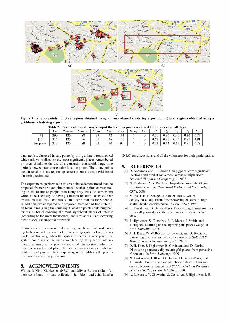
(a) (b)
(c)Figure 4: a) Stay points. b) Stay regions obtained using a density-based clustering algorithm. c) Stay regions obtained using agrid-based clustering algorithm.
Table 2: Results obtained using as input the location points obtained for all users and all days.Disc. Remem. Correct Missed False Forg. Merg. Div. R Pα Fα Pβ Fβ
[6] 290 125 88 33 42 161 4 0 0.70 0.30 0.42 0.86 0.77[15] 314 125 96 25 46 172 4 0 0.76 0.31 0.44 0.85 0.81
Proposed 212 125 89 31 30 92 4 0 0.71 0.42 0.53 0.85 0.78
data are first clustered in stay points by using a time-based methodwhich allows to discover the most significant places rememberedby users thanks to the use of a constraint that avoids large timeperiods between two consecutive location points. Then, stay pointsare clustered into stay regions (places of interest) using a grid-basedclustering technique.
The experiments performed in this work have demonstrated that theproposed framework can obtain more location points correspond-ing to actual life of people than using only the GPS sensor andwithout the necessity of having a beacon location database. Ourevaluation used 24/7 continuous data over 5 months for 8 people.In addition, we compared our proposed method and two state-of-art techniques (using the same input location points) obtaining bet-ter results for discovering the most significant places of interest(according to the users themselves) and similar results discoveringother places less important for users.
Future work will focus on implementing the place-of-interest learn-ing technique in the client part of the sensing system of our frame-work. In this way, when the system discovers a new place, thesystem could ask to the user about labeling the place to add se-mantic meaning to the places discovered. In addition, when theuser reaches a learned place, the device can ask the user whetherhe/she is really in this place, improving and simplifying the places-of-interest evaluation procedure.
8. ACKNOWLEDGMENTSWe thank Niko Kiukkonen (NRC) and Olivier Bornet (Idiap) fortheir contribution to data collection, Jan Blom and Juha Laurila
(NRC) for discussions, and all the volunteers for their participation.
9. REFERENCES[1] D. Ashbrook and T. Starner. Using gps to learn significant
locations and predict movement across multiple users.Personal Ubiquitous Computing, 7, 2003.
[2] N. Eagle and A. S. Pentland. Eigenbehaviors: identifyingstructure in routine. Behavioral Ecology and Sociobiology,63(7), 2009.
[3] M. Ester, H. P. Kriegel, J. Sander, and X. Xu. Adensity-based algorithm for discovering clusters in largespatial databases with noise. In Proc. KDD, 1996.
[4] K. Farrahi and D. Gatica-Perez. Discovering human routinesfrom cell phone data with topic models. In Proc. ISWC,2008.
[5] J. Hightower, S. Consolvo, A. LaMarca, I. Smith, andJ. Hughes. Learning and recognizing the places we go. InProc. Ubicomp, 2005.
[6] J. H. Kang, W. Welbourne, B. Stewart, and G. Borriello.Extracting places from traces of locations. SIGMOBILEMob. Comput. Commun. Rev., 9(3), 2005.
[7] D. H. Kim, J. Hightower, R. Govindan, and D. Estrin.Discovering semantically meaningful places from pervasiverf-beacons. In Proc. Ubicomp, 2009.
[8] N. Kiukkonen, J. Blom, O. Dousse, D. Gatica-Perez, andJ. Laurila. Towards rich mobile phone datasets: Lausannedata collection campaign. In ACM Int. Conf. on PervasiveServices (ICPS), Berlin, Jul. 2010, 2010.
[9] A. LaMarca, Y. Chawathe, S. Consolvo, J. Hightower, I. E.

Smith, J. Scott, T. Sohn, J. Howard, J. Hughes, F. Potter,J. Tabert, P. Powledge, G. Borriello, and B. N. Schilit. Placelab: Device positioning using radio beacons in the wild. InPervasive, 2005.
[10] L. Liao, D. Fox, and H. Kautz. Extracting places andactivities from gps traces using hierarchical conditionalrandom fields. International Journal of Robotics Research,26(1), 2007.
[11] N. Marmasse and C. Schmandt. Location-aware informationdelivery with commotion. In Proc. Huc, 2000.
[12] D. J. Patterson, L. Liao, D. Fox, and H. A. Kautz. Inferringhigh-level behavior from low-level sensors. In Proc.Ubicomp, 2003.
[13] S. Reddy, J. Burke, D. Estrin, M. Hansen, and M. Srivastava.Determining transportation mode on mobile phones. In Proc.ISWC, 2008.
[14] Y. Wang, J. Lin, M. Annavaram, Q. A. Jacobson, J. Hong,B. Krishnamachari, and N. Sadeh. A framework of energyefficient mobile sensing for automatic user state recognition.In Proc. MobiSys, 2009.
[15] Y. Ye, Y. Zheng, Y. Chen, J. Feng, and X. Xie. Miningindividual life pattern based on location history. In Proc.MDM, 2009.
[16] V. W. Zheng, Y. Zheng, X. Xie, and Q. Yang. Collaborativelocation and activity recommendations with gps history data.In Proc. WWW, 2010.
[17] Y. Zheng, Q. Li, Y. Chen, X. Xie, and W.-Y. Ma.Understanding mobility based on gps data. In Proc.Ubicomp, 2008.
[18] Y. Zheng, L. Liu, L. Wang, and X. Xie. Learningtransportation mode from raw gps data for geographicapplications on the web. In Proc. WWW, 2008.