discover v11.0 release notes - pitney...
TRANSCRIPT
What’s New in Discover 11?
Support for MapInfo Professional 10.•
Updated support for version 4.2.0 •of the acQuire database model.
Direct link to our regularly updated and •searchable online Knowledge Base.
New Command Search function (either •by tool name or keywords) means no more browsing through multiple menustofindthatelusivetool.
release notes
discover version 11.0
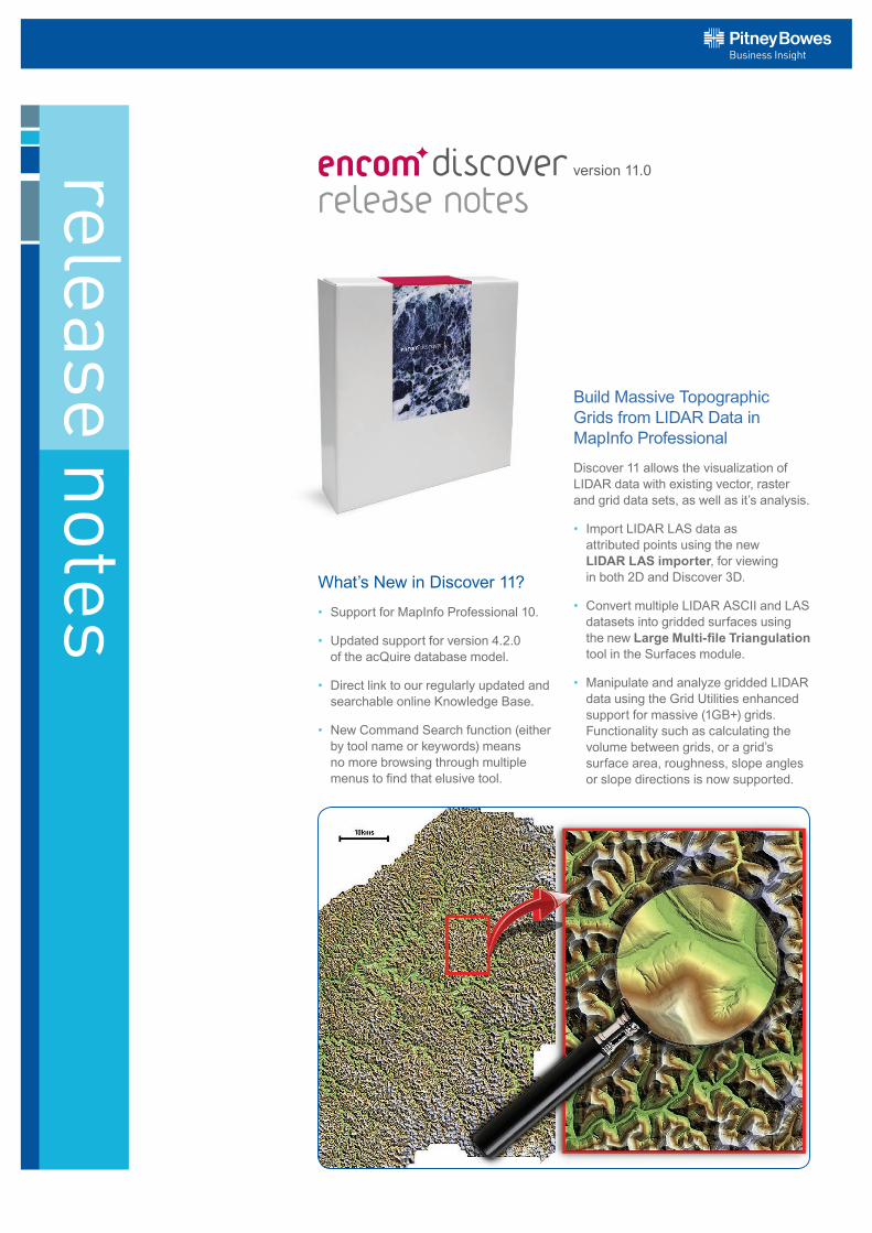
Build Massive Topographic Grids from LIDAR Data in MapInfo Professional
Discover 11 allows the visualization of LIDAR data with existing vector, raster and grid data sets, as well as it’s analysis.
Import LIDAR LAS data as •attributed points using the new LIDAR LAS importer, for viewing in both 2D and Discover 3D.
Convert multiple LIDAR ASCII and LAS •datasets into gridded surfaces using the new Large Multi-file Triangulation tool in the Surfaces module.
Manipulate and analyze gridded LIDAR •data using the Grid Utilities enhanced support for massive (1GB+) grids. Functionality such as calculating the volume between grids, or a grid’s surface area, roughness, slope angles or slope directions is now supported.
release notes
Continued Support for Multi-Gigabyte Grids
Enhanced Grid UtilitiesBuilding on the very large grid (e.g. continental-scale) import and visualization support implemented previously, Discover 11 can now manipulate massive grids using its powerful Grid Utilities, such as Reproject, Clip, Overlay and Merge.
New Large Multi-file triangulation tool
Discover can now build very large gridsfrommultipleinputfilesand/ormassive data sets such as LIDAR data.
Interpolatemultipleinputfiles•into a single gridded surface using triangulation.
Interpolate massive data sets such •as LIDAR ASCII and LAS data, TABpointandcontourfilesintogriddedfilesusingtriangulation.
New large grid formats supported
USGS DEM grids•
USGS grids•
Geopak grids•
GeoTIFFs with embedded elevation•
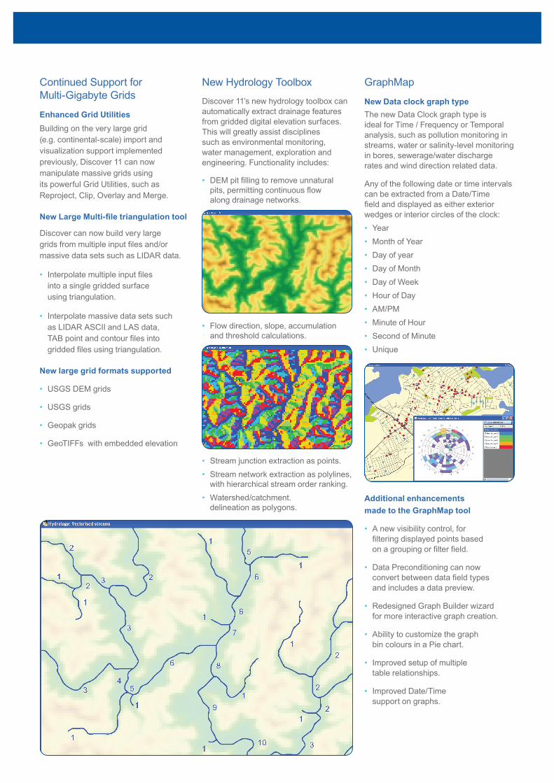
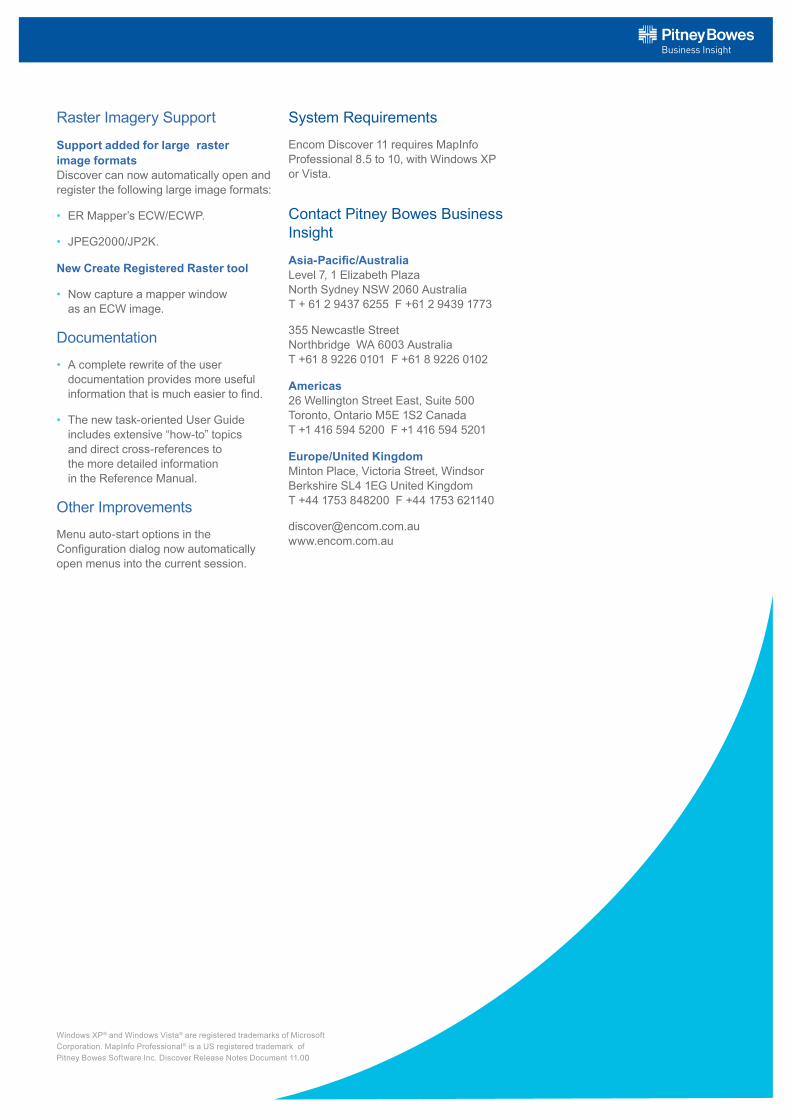
New Hydrology Toolbox
Discover 11’s new hydrology toolbox can automatically extract drainage features from gridded digital elevation surfaces. This will greatly assist disciplines such as environmental monitoring, water management, exploration and engineering. Functionality includes:
DEMpitfillingtoremoveunnatural•pits,permittingcontinuousflowalong drainage networks.
Flow direction, slope, • accumulation and threshold calculations.
Stream junction extraction as points.•Stream network extraction as polylines, •with hierarchical stream order ranking.Watershed/catchment.•delineation as polygons.
GraphMap
New Data clock graph typeThe new Data Clock graph type is idealforTime/FrequencyorTemporalanalysis, such as pollution monitoring in streams, water or salinity-level monitoring inbores,sewerage/waterdischargerates and wind direction related data.
Any of the following date or time intervals canbeextractedfromaDate/Timefieldanddisplayedaseitherexteriorwedges or interior circles of the clock:
Year•Month of Year •Day of year•Day of Month•Day of Week•Hour of Day•AM/PM•Minute of Hour•Second of Minute•Unique•
Additional enhancements made to the GraphMap tool
A new visibility control, for •filteringdisplayedpointsbasedonagroupingorfilterfield.
Data Preconditioning can now •convertbetweendatafieldtypesand includes a data preview.
Redesigned Graph Builder wizard •for more interactive graph creation.
Ability to customize the graph •bin colours in a Pie chart.
Improved setup of multiple •table relationships.
ImprovedDate/Time•support on graphs.

Drillholes
New Polyline Section definition tool Drillhole cross sections can now bedefinedalonganon-linearpath, using a selected polyline (for vertical drillholes only).
This functionality is ideal for the hydrological, geological and environmental engineering industries who often need to analyze data along non linear sections such as pipe lines, roads, tunnels and subsurface palaeochannels oraquifers.
New Project Session managementProject Sessions allow cross-section and plan layouts and all associated components (titleblock, legends, scale bars, map windows, etc.) to be easily saved and reopened, much like a MapInfo Professional workspace. However, drillhole project sessions also preserve the parent drillhole project, reopeningalltherequireddataandsettings when the session is opened.
This is a very powerful way of handling projects when saving multiple sections’ layout windows for hardcopy output, or regularly opening a number of cross-section map windows.
New Display Downhole Data toolA completely redesigned tool makes creatingandfinessingthedownholedata displays on your sections interactive and painless. New features include:
An intuitive interface that provides clear •visualizationandeasymodificationof display settings, including the adjustment of the individual display type offsets with respect to each other.
Downhole display settings are •now easily shared between users. Thesecanbeprojectspecific,andare automatically stored with each section for hassle-free reuse.
The width of linegraphs and histograms •cannowbespecified(ratherthanascale) in millimetres, allowing precise sizing control to prevent overlaps.
Other changesAdditional interface and performance improvements have been made to the following tools:
Project Manager•Section Manager•Draw Section Grid•Add Section Layout•
New Tenement Module
The Discover Tenement module has been completely redesigned to provide an interactive interface for creating new applications, searching through existing tenement data and for downloading regular tenement updates:
Download regularly-updated Australian •mineral tenement data via a web-based subscription service. Straightforward tenement •queryingbydate,licencetypeand holder information. New application interface with •interactive state and datum selection. Create polygonised block and •sub-block reference grids.Create new or modify existing •applications by selecting sub-blocks manually or interactively, including sub-block counter, limit and area checks.Tenement application reports •automatically created for entry into standard statutory application forms.
New Import Support
DataSight database importer: •Import data directly from the DataSight environmental data management platform.
ioGAS Importer. •
LIDAR LAS importer: Import LIDAR •data as points. LAS data can now also be gridded using the new Large Multi-file Triangulation tool.
Raster Imagery Support
Support added for largesraster image formatsDiscover can now automatically open and register the following large image formats:
ERMapper’sECW/ECWP.•
JPEG2000/JP2K.•
New Create Registered Raster tool
Now capture a mapper window •as an ECW image.
Documentation
A complete rewrite of the user •documentation provides more useful informationthatismucheasiertofind. i
The new task-oriented User Guide •includes extensive “how-to” topics and direct cross-references to the more detailed information in the Reference Manual.
Other Improvements
Menu auto-start options in the Configurationdialognowautomaticallyopen menus into the current session.
SystemRequirements
EncomDiscover11requiresMapInfoProfessional 8.5 to 10, with Windows XP or Vista.
Contact Pitney Bowes Business Insight
Asia-Pacific/AustraliaLevel 7, 1 Elizabeth Plaza North Sydney NSW 2060 Australia T + 61 2 9437 6255 F +61 2 9439 1773
355 Newcastle Street Northbridge WA 6003 Australia T +61 8 9226 0101 F +61 8 9226 0102
Americas26 Wellington Street East, Suite 500 Toronto, Ontario M5E 1S2 Canada T +1 416 594 5200 F +1 416 594 5201
Europe/United KingdomMinton Place, Victoria Street, Windsor Berkshire SL4 1EG United Kingdom T +44 1753 848200 F +44 1753 621140
[email protected] www.encom.com.au
Windows XP® and Windows Vista® are registered trademarks of Microsoft Corporation. MapInfo Professional® is a US registered trademark of Pitney Bowes Software Inc. Discover Release Notes Document 11.00