discover british columbia’s our guide - northern bc€¦ · discover british columbia’s ......
TRANSCRIPT

www.StewartCassiarHighway.com i
Road TourGuide
Discover British Columbia’s
www.StewartCassiarHighway.com
landscape • history culture • wildl ife
TRAVEL THE GREAT NORTHERN CIRCLE TOUR!Hwy 37

SitesKitwanga Totem PolesKitwancool-Gitanyow Totem PolesNisga’a HighwayMeziadan River Fish LadderHighway 37ABell II, Tatogga, IskutIskut Lakes & Iskut River ValleyKinaskan Lake Provincial Park / Natadesleen TrailStikine RiverGnat Pass / Klappan Road / Rail GradeTelegraph Road / Stikine CanyonSawmill PointCassiar / Jade CityBoya Lake
1
2
3
4
5
6
7
8
9
10
11
12
13
14
accommodations interpretive trail
boat launch mountain biking
camping museum
canoeing / kayaking
picnic site
drinking water rv parking
first nations history swimming
fishing telephone
gas toilets
hiking wheelchair access
internet wildlife viewing
Paved or hard surfaceGravelFerry Route (approximate)Provincial Campground
Legend & Features not to scale
Discover campingreservation site for bc parks https://secure.camis.com/Discovercamping/
TRAVEL THE GREAT NORTHERN CIRCLE TOUR!Hwy 37
Mileage Chart
kilometresmiles
Kitwanga Hwy 37N & 16
15697
220137
406252
488303
508378
724450
746474
1155718
Meziadin Junction 15697
6440
249155
333207
453282
568353
590367
999621
Stewart/Hyder 220137
6440
314195
398247
518322
632393
654407
1063660
Iskut/Tatogga 406252
249155
314195
8452
204127
319198
341112
750466
Dease Lake 488303
333207
398247
8452
12075
235146
257160
667414
Telegraph Creek 508378
453282
518322
204127
12075
355221
377235
787489
Alaska Hwy Junction 724450
568353
632393
319198
235146
355221
2214
431268
Alaska Hwy Watson Lake east
746474
590367
654407
341112
257160
377235
2214
453282
Alaska Hwy Whitehorse west
1155718
999621
1063660
750466
667414
787489
431268
453282
Kit
wa
ng
a
Hw
y 37
N &
16
Me
zia
din
Ju
nct
ion
Ste
wa
rt/
Hyd
er
Isku
t/Ta
tog
ga
De
ase
La
ke
Tele
gra
ph
Cre
ek
Ala
ska
Hw
y Ju
nct
ion
Ala
ska
Hw
y
Wa
tso
n L
ake
eas
tA
lask
a H
wy
W
hit
eh
ors
e w
est
16
9797
16
37
37
37A
12
45
8
9
1011
12
13
14
3
MILE / KM 0
if your driving tour starts here
MILE 398 / KM 640
if your driving tour
ends here
Liard River
Watson Lake
Good Hope LakeJade City
Telegraph CreekGlenora
Dease Lake
Iskut
Tatogga Lake
Bob Quinn
Meziadin Junction
The Hazeltons
Smithers
Terrace
Gitwangak/Kitwanga
Stewart
New Aiyansh
Hyder, Alaska
Meziadin Lake Provincial Park Campground
Nisga’a Memorial Lava Bed Provincial
Park
Bell II
former Cassiar
townsite
Yukon Territory
British Columbia 98 km61 miles
138 km86 miles
83 km52 miles
107 km66 miles
48 km30 miles
94 km59 miles
156 km97 miles
67 km42 miles
120 km75 miles
Boya Lake Provincial Park Campground
Mount Edziza Park
Spatsizi Plateau Wilderness Park
Kinaskan Lake Provincial Park
CampgroundDea
se R
iver
Dease Lake
Bowser Lake
Stiki
ne R
iver
Iskut River
Portland Canal Nass River
Skeena River
Yellowhead Highway
Bell Irving River
Stikine River
Alaska Highway
British ColumbiaAlaska
Gitanyow/Kitwancool
6 7
6

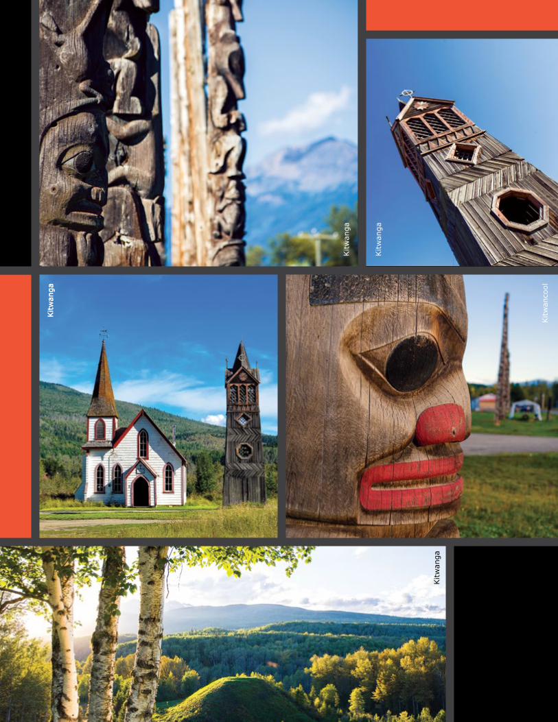
Kitwancool-Gitanyow Totem PolesA significant collection of totem poles can be found at the village of Gitanyow (formerly Kitwancool), 15 kms north of Kitwanga. This site is rich in First Nations culture, history and archaeology. Old carving sheds and a graveyard contribute to the magical feeling here, famously captured in paintings by Emily Carr. Gas, phone and a small store are available on-site; other services including RV camping can be found at Kitwanga. Besides viewing salmon and eagles at the Kitwanga river, watch for the legendary Kermode (white spirit bears) found in this area.
2
see page 1
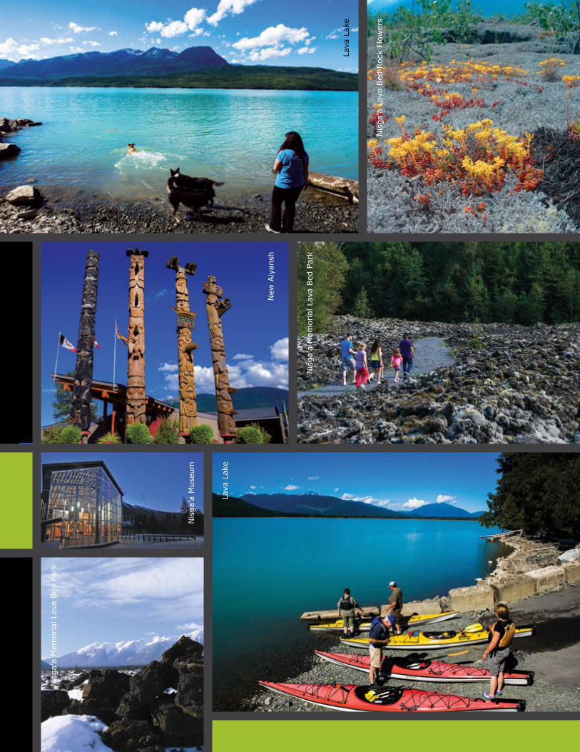
Nisga’a HighwayTake the Nisga’a Highway north from Terrace or west from Highway 37 to discover the lands of the Nisga’a First Nation. Walk though the lava beds that were deposited here over 250 years ago during a volcanic eruption that killed thousands. Stop at the Nisga’a Memorial Lava Beds Provincial Park to get a guided tour of the volcanic crater, and learn more at the park’s Visitor Info Centre, built as a traditional longhouse. And be sure to check out the new Nisga’a Museum in Laxgalts’ap (Greenville). Take a scenic side-trip downstream along the shore of the mighty Nass River to Kincolith, a First Nation village located where the river flows into the Pacific Ocean.
3
see pages 2-3
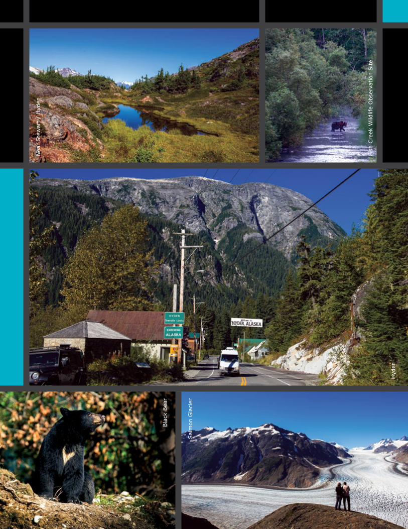
Highway 37A: Meziadin to StewartFor a dramatic and rewarding side-trip, take the 65-km drive on Highway 37A to Stewart. This well-built road is fun and exciting, with fantastic scenery unfolding around every bend. Along the way you pass below overhanging glaciers on the nearby mountains, and beside the Bear Glacier as it ends in a lake at road level. Set at sea level at the northern end of the Portland Canal, Stewart offers full facilities and charm including restaurants, motels, gas stations, bakeries, and museums. Follow the road through town into Hyder, Alaska, where you can watch grizzly and black bears catching and eating salmon at the Fish Creek bear-viewing platform. Further along, the road climbs steadily into the subalpine above the Granduc Mine. You can hike from here onto the rolling ridges above.
5
see pages 6-9
Kinaskan Lake ProvincialPark/ Natadesleen Lake TrailThis popular and relaxing spot, with its well-maintained 50-site campground, offers spectacular panoramic views, great trout fishing and excellent wildlife viewing. Kinaskan Lake is part of Tahltan traditional territory and is the starting point for a historical 20 km trail that leads to the volcanic cinder-cones of the Mt. Edziza area. Another trail leaves Highway 37 about 10 km south of Kinaskan Lake and leads 1 km to the shore of Natadesleen Lake. Portage your canoe here and fish, or paddle across the Lake to the outlet where a rough trail follows the fast-moving Iskut River to Cascade Falls 300m below the lake.
8
see page 15
Kitwanga Totem PolesKitwanga, at the southern end of Highway 37, is one of the best places in BC to see authentic totem poles. Now a National Historic Site, some 50 amazing totems are within an hour’s drive from here. The Seven Sisters Mountain Range lends a spectacular scenic backdrop to the area. Visit Battle Hill, a fortified village occupied during the late 1700s by the Gitwangak First Nation. Strategically located, it was encircled by spiked logs designed to roll onto approaching enemies. Watch for black bears with cubs on the roadsides in spring, and feeding on salmon in late summer and early fall.
1
see page 1
Stikine River After the steep descent into the Stikine River valley, stop at the bridge to take in the landscape and history of the area. It was not until 1973 that a bridge existed at this location; previous to that time there was a small ferry here. A popular week-long wilderness canoe route from the upper Stikine ends here, and just downstream the river enters the formidable Grand Canyon of the Stikine, considered unnavigable except by the most extreme kayakers. Jet-boat tours of the river are available. For thousands of years the Stikine was a main First Nations’ transportation route, and in the late 1800s became the principal route to the Yukon’s Klondike goldfields.
9
see page 15
Gnat Pass/BC Rail gradeGnat Pass, at over 4,000 ft, provides the best view of the old BC Rail grade, a railroad through the wilderness that was never completed. It now provides rough road access into some of BC’s remote interior. Both Upper and Lower Gnat Lakes offer scenic and serene canoeing and fishing. Trumpeter swans can be seen on the lakes during their migration in spring and fall. Several rough tracks from the vicinity provide hiking access to alpine areas. Northern Mountain caribou abound in fall, winter and spring. Other wildlife includes wolves, bears, lynx, wolverine and eagles.
10
see page 17
Sawmill PointThe Sawmill Point Recreation Site, 41 km north of the community of Dease Lake, gives access to Dease Lake itself. Once the site of a very short-lived Hudson’s Bay Company post established in 1838 and abandoned in 1839, it is today a popular camping and fishing spot for locals and travellers alike. Try your hand at catching the good-sized lake trout here, and look for the remains of the foundation of the old fort. The lake has historically been an important First Nations’ transportation corridor. Camping is available here and motel accommodations can be found in the nearby town of Dease Lake.
12
see page 23
Cassiar/Jade CityJade City, named for the rich jade deposits found in the area, offers overnight RV parking, washrooms, coffee, a jade picture gallery and an interactive mining museum. Just north of here, a short 10-km drive from the highway leads to the asbestos-mining ghost town of Cassiar. Closed in 1992, flowers now bloom where houses once stood, and an abandoned tramline still stands. Note: there are no public facilities in the old town-site, and it is closed to visitors. The Cassiar gold rush left a rich history of mining claims for nature to reclaim. Abandoned cabins and equipment let you imagine the life of early miners and settlers. At the old Cassiar graveyard you will recognise many names now found on the map as mountains, rivers and other place-names.
13
see page 23
Boya LakeWith islands and shorelines that inspire tranquillity and wonder, Boya Lake may be the best lake in Northern BC for canoeing and kayaking. Look into its depths to see fish, ducks and beavers swimming below you, visible against the white marl bottom. Its unique aqua-green hue and relatively warm and swimmable water makes Boya lake a must-visit place on your journey to the north. Camping along with canoe and kayak rentals are available from the park operator. Two interpretive trails lead from the campground around the shores of the lake where you will find a wide variety of wildflowers, and a chance to see beavers hard at work, moose rearing their calves, and roaming caribou. Boya Lake lies within the traditional territory of the Kaska Dene First Nation who continue to hunt and trap in the area.
14
see page 23
Telegraph Rd/Dease Lake /Stikine Canyon
For a journey back into history and geologic time, take the road from Dease Lake to Telegraph Creek. Following a First Nations’ trading route and the path of early gold-seekers, the road follows the ledges of the lower Stikine Canyon, with dramatic views of the sheer walls created by the river cutting its way through layers of volcanic lava. Mountain goats find protection among the ledges and rock outcrops of the canyon. The breathtaking road finally descends to the community of Telegraph Creek, which was the limit of navigation on the river for boats travelling upstream from the coast. The Stikine has been inhabited for centuries by the Tahltan First Nation, who still live in the area and harvest the Stikine’s prolific salmon run. Scenic floatplane flights and rafting trips are available, as well as a heart-stopping helicopter tour into the Stikine’s Grand Canyon. Services such as fuel, accommodation and groceries are available in Dease Lake.
11
see pages 18-21
Meziadin AreaLocated just downstream from Meziadin Lake, the Meziadin River Fish Ladder is a popular stop for fish and wildlife viewing. Large chinook and sockeye salmon can be seen leaping into the air as they navigate the ladder in late summer. Grizzly and black bears, eagles and moose may often be spotted here. Access:100m north of the Nass River Bridge turn west on the logging road. At 1km, follow the gravel trail south about 0.5 km on the east side of the Meziadin River. This road may not be suitable for large RVs—walking is recommended. Camping (with Internet) is available 15 km north at Meziadin Lake Provincial Park. Fishing and boating are excellent here. Bear watching and salmon viewing opportunities abound at Hanna Creek 2 km south of the Park.
4
see pages 4-5
Bell II, Tatogga, IskutBell II is located where Highway 37 crosses the Bell Irving River. Most services are available here including food, fuel and accommodation. Bell II is a gateway to incredible lakes, streams, rivers and mountain ranges with spectacular wildlife viewing. Heading north, you will drive through the small, unincorporated community of Tatogga. Charter a float plane, hire a wilderness guide and rent boating and fishing gear from Tatogga to explore the lakes and mountains that surround the region. Even further north is the community of Iskut, home of the Tahltan First Nation. Iskut is situated between Mount Edziza and the Spatzizi Plateau Wilderness Park. Iskut also has basic services for visitors either travelling through or enjoying the region.
6
see pages 10-11
Iskut Lakes & Iskut River ValleyThe Iskut Lakes and Iskut River Valley is one of the world’s last wild frontiers. This scenic corridor boasts multiple provincial parks with camping, hiking, fishing and boating along a chain of over 50km of lakes and rivers. This area is home to the worlds largest population of Stone Sheep, with Mountain Goat, Grizzly and Black Bear, Moose and Caribou frequenting the area. Hike to Mount Edziza, North America’s youngest volcanic cone and experience the world famous Stikine River in all its might and power. If outdoor adventure is what you seek, make sure to give yourself some time to explore this incredible region of the north west.
7
see pages 12-15
Kitw
anga
Kitw
anga
Kitw
anga
Kitw
anga
Kitw
anga
Kitw
anco
ol

www.StewartCassiarHighway.com 1
Highway 37 heading north to
www.StewartCassiarHighway.com
Kitwanga - Kitwancool
Community of Kitwanga Kitwanga, or Gitwangak (“place of rabbits”), the starting point of the Stewart Cassiar Highway, is at the junction of Highways 16 and 37 and the confluence of the Kitwanga and Skeena Rivers. Outstanding carved cedar poles - some more than a century old - are found here, as well as St. Paul’s Anglican Church, built in 1893. There are more than 50 incredible totem poles within an hour’s drive. Kitwanga is also adjacent to the Upper Skeena “Grease Trail”, named after the eulachon oil trading route that connected the inland and coastal First Nations. The Grease Trails are believed to have extended as far north as the Bering Sea.
This is also the site of the Gitwangak Battle Hill National Historic Site of Canada. This site commemorates the struggle of Battle Hill, a fortified village occupied by the Gitwangak
◆ Totem Poles◆ Battle Hill◆ Highway 16/37
Junction
First Nation in the late 1700s and early 1800s. The fort was strategically located atop a hill with views of the valley and river. Gitwangak warriors would roll logs down the hill to stop attackers. The historic site includes a self-guided tour and ample parking for RV’s.
Community of Gitanyow Gitanyow, or Kitwancool, is 15 kilometers (nine miles) north of Kitwanga and was designated a National Historic Site in 1972. Gitanyow, at one point, had the one of the largest number of original totem poles of any Coastal First Nations village, many dating from the mid 19th century. Now, less than twenty original poles remain. Some were sent to the Provincial Museum in Victoria, in about 1960, in exchange for replicas by noted Kwakiutl carver, Henry Hunt. The copies were re-erected in 1970, and the remaining poles were restored and re-erected by the Skeena River Totem Pole Preservation Society in 1968. Famous Canadian artist Emily Carr visited in 1928, and painted many of the village’s poles. Magnificent poles, carving sheds and a graveyard contribute to the magical feeling of the site.
16
9797
16
37
37
37A
Liard River
Watson Lake
Good Hope LakeJade City
Telegraph CreekGlenora
Iskut
Tatogga Lake
Dease Lake
Bob Quinn
Meziadin Junction
The Hazeltons
Smithers
Terrace
Gitwangak / Kitwanga
Stewart
New Aiyansh
Hyder, Alaska
Meziadin Lake Provincial Park Campground
Nisga’a Memorial Lava Bed Provincial
Park
Bell II
former Cassiar
townsite
Yukon Territory
British Columbia 98 km61 miles
138 km86 miles
83 km52 miles
48 km30 miles
94 km59 miles
156 km97 miles
67 km42 miles
120 km75 miles
Boya Lake Provincial Park Campground
Mount Edziza Park
Spatsizi Plateau Wilderness Park
Kinaskan Lake Provincial Park
Campground
Dease
Rive
r
Dease Lake
Bowser Lake
Stiki
ne R
iver
Iskut River
Portland Canal Nass River
Skeena River
Yellowhead Highway
Bell Irving River
Stikine River
Alaska Highway
British ColumbiaAlaska Gitanyow / Kitwancool
107 km66 miles
Kitw
anco
ol
Lava
Lak
e
Lava
Lak
e
Nis
ga’a
Mus
eum
Nis
ga’a
Lav
a Bed
Roc
k Fl
ower
s
New
Aiy
ansh
Nis
ga’a
Mem
oria
l Lav
a Bed
Par
k
Nis
ga’a
Mem
oria
l Lav
a Bed
Par
k

www.StewartCassiarHighway.com 3www.StewartCassiarHighway.com 3
The Nass Valley – home of the self-governed Nisga’a First Nation– is a side trip worth taking. The main access is via the Nisga’a Highway, north from Terrace off of Highway 16. The Nass Valley is also accessible from Highway 37, albeit a rougher road. From Highway 37, turn west at km 76 onto the Nass Forest Service Road, a narrow, winding, 61 km gravel road to New Aiyansh. (Note- This is a Forest Service Road with limited maintenance and drivers are asked to take additional care when driving this route.)
The Nass River travels through a valley formed by molten lava on its way to the Pacific Ocean. The Nisga’a Memorial Lava Bed Provincial Park is the site of Canada’s most recent volcanic eruption. The lava beds were created in 1750, about the time the Spanish explorers arrived in the area. Starting from a small cinder cone, lava flowed into the Nass River
◆ Museum◆ Lava Bed Park◆ Nisga’a
Valley and travelled downstream, creating a lake with red sand beaches.
The Nass Valley is comprised of the four Nisga’a villages of Gitlaxt’aamiks (New Aiyansh)-Capital of the Nisga’a Nation, Gitwinksihlkw (Canyon City), Laxgalts’ap (Greenville) and Gingolx (Kincolith)-Seafood Capital of the Nass.
Nisga’a MuseumThe Nisga’a Museum and its collection are directly related to the historic Nisga’a Final Agreement (treaty). The Ancestor’s Collection is made up of 330 artifacts and art objects that through the treaty process, were returned from the Royal British Columbia Museum and Canadian Museum of Civilization to the Nisga’a people. This unique collection includes carved masks, bentwood boxes, headdresses, soul catchers, and other works of art known as Anhooya’ahl Ga’angigatgum’ – the Ancestors’ Collection. The museum is open seasonally from mid-May through to late October. For more information visit www.nisgaamuseum.ca
Nisga’a Memorial Lava Bed ParkAnhluut’ukwsim Laxmihl Angwinga’asanskwhl Nisga’a (Nisga’a Memorial Lava Bed Park) features a dramatic volcanic landscape, and was the first British Columbia provincial park to combine interpretation of natural features and native culture. Nisga’a Memorial Lava Bed Park is also the first provincial park to be jointly managed by a First Nation and BC Parks. Lava features visible include tree casts, lava tubes, and blocky lava. Please stay on designed paths. Download a map of the Nisga’a Memorial Lava Bed Park from BC Parks.
Nass Valley {side trip}
16
9797
16
37
37
37A
Liard River
Watson Lake
Good Hope LakeJade City
Telegraph CreekGlenora
Iskut
Dease Lake
Tatogga Lake
Bob Quinn
Meziadin Junction
The Hazeltons
Smithers
Terrace
Gitwangak/Kitwanga
StewartHyder, Alaska
Meziadin Lake Provincial Park Campground
Nisga’a Memorial Lava Bed Provincial Park Nisga’a
Highway
Bell II
former Cassiar
townsite
Yukon Territory
British Columbia 98 km61 miles
138 km86 miles
83 km52 miles
48 km30 miles
94 km59 miles
156 km97 miles
67 km42 miles
120 km75 miles
Boya Lake Provincial Park Campground
Mount Edziza Park
Spatsizi Plateau Wilderness Park
Kinaskan Lake Provincial Park
Campground
Dease
Rive
r
Dease Lake
Bowser Lake
Stiki
ne R
iver
Iskut River
Portland Canal Nass River
Skeena River
Yellowhead Highway
Bell Irving River
Stikine River
Alaska Highway
British ColumbiaAlaska
Gitanyow/KitwancoolNew
Aiyansh
107 km66 miles

Mez
iadi
n La
ke
Fox
Mez
iadi
n La
keM
ezia
din
Lake
www.StewartCassiarHighway.com 5
Highway 37 heading north to
www.StewartCassiarHighway.com
MeziadinMeziadin Fish LadderLocated just downstream from Meziadin Lake, the Meziadin River Fish Ladder is a popular stop for fish and wildlife viewing. Large Chinook and Sockeye salmon can be seen leaping into the air as they navigate the ladder in late summer to return to their spawning grounds. Grizzly and black bears, eagles, moose and wolves are often spotted here. Roughly 100 meters past (north) of the Nass River Bridge, turn off to the left (west). After 1km, follow the gravel trail south about 0.5 km along the side of the Meziadin River. Large RV’s should park at the top of the hill and walk down, as the road may not be suitable for them.
Built for salmon to navigate past Victoria Falls, the original fish ladder was built in 1914 and replaced in 1966. Today, 70 to 80 percent of the Nass River Sockeye Salmon run return to the Meziadin system, accounting for over 200,000 fish counted each season.
Historically, this place represents one of the main fishing sites of both the Nisga’a and Gitanyow people. Today, this significance is still seen in seasonal fishing camps and smokehouses along the north bank of the Meziadin River, and the use of traditional dipnet fishing methods by the Gitanyow.
Meziadin Lake (Grizzly Viewing)Meziadin Lake Provincial Park is a popular summer campsite and fishing spot. The park has recently been updated with 66 vehicle sites, most directly on the lake. The lake boasts excellent fishing for Rainbow Trout, Mountain Whitefish and Dolly Varden. The salmon spawning creeks, which feed Meziadin Lake, are favourite feeding grounds for grizzlies. The lake is one of only three places in the province where salmon spawn in the bays and inlets of a lake, rather than a river. Four species of salmon return yearly. Internet (wifi) access available.
Meziadin JunctionMeziadin Junction is located at the intersection of Highway 37 (north) and Highway 37A, which leads west to Stewart, BC and Hyder, Alaska.
There is a small general store at Meziadin Lake Provincial Park selling basic groceries as well as fishing licenses, tackle and guided tours of the lake and area. Fuel is available at either Stewart (64km west) or Bell 2 (94km north).
16
9797
16
37
37
37A
Liard River
Watson Lake
Good Hope LakeJade City
Telegraph CreekGlenora
Iskut
Dease Lake
Tatogga Lake
Bob Quinn
Meziadin Junction
The Hazeltons
Smithers
Terrace
Gitwangak/Kitwanga
Stewart
New Aiyansh
Hyder, Alaska
Meziadin Lake Provincial Park Campground
Nisga’a Memorial Lava Bed Provincial
Park
Bell II
former Cassiar
townsite
Yukon Territory
British Columbia 98 km61 miles
138 km86 miles
83 km52 miles
48 km30 miles
94 km59 miles
156 km97 miles
67 km42 miles
120 km75 miles
Boya Lake Provincial Park Campground
Mount Edziza Park
Spatsizi Plateau Wilderness Park
Kinaskan Lake Provincial Park
Campground
Dease
Rive
r
Dease Lake
Bowser Lake
Stiki
ne R
iver
Iskut River
Portland Canal Nass River
Skeena River
Yellowhead Highway
Bell Irving River
Stikine River
Alaska Highway
British ColumbiaAlaska
Gitanyow/Kitwancool
107 km66 miles
◆ Fish Ladder
◆ Camping◆ Salmon

Bea
r G
laci
er
Wat
er F
alls
Nea
r Ste
war
t
Ste
war
t
Sal
mon
Gla
cier
Bea
r G
laci
er

www.StewartCassiarHighway.com 7
Meziadin to Stewart {side trip}
www.StewartCassiarHighway.com
For a dramatic and rewarding side-trip, take the 65-km drive on Highway 37A to Stewart. This well-built road is as exciting as it is scenic with overhanging glaciers, mountains and wildlife around every bend.
Stewart The town of Stewart sits at the head of the Portland Canal, a steep, narrow ocean fjord that forms a natural boundary between British Columbia and Alaska. With a population of approximately 500, Stewart has all the amenities of a larger town, including restaurants, motels, gas stations, bakeries, and museums.
Before the stock market crash of 1929, Stewart was a
boomtown of more than ten thousand people. It was the base for people working in the enormous and fabulously rich Premier gold and silver mine, the Big Missouri Mine and the Riverside Mine. The town’s colourful history is now chronicled in the Stewart Historical Museum, as well as a number of restored heritage buildings that are marked by historic signage.
The Stewart/Hyder area offers an excellent range of outdoor recreational opportunities. Charter boats and guides will take you out on the waters of the Portland Canal to fish for salmon or halibut, or show you an eco-paradise filled with bears, porpoise, mountain goats and eagles.
OTHER ATTRACTIONS INCLUDE: An Estuary Boardwalk with a spectacular view of the Portland Canal, a golf facility with a mountain backdrop and Bear Glacier, visible from the road into Stewart. For more information on Stewart and the surrounding area visit www.districtofstewart.com
Salmon GlacierAnother spectacular sight is the Salmon Glacier, which is a 37km (23 mile) drive from Stewart, via Hyder. The Salmon Glacier, the fifth largest in Canada, is a remnant of that last great age of glaciers. The self-guided sightseeing tour along Salmon Glacier Road, built to connect Stewart to mining interests, is a must when visiting the area! Summit viewpoint provides a perfect view of the area and has facilities making it a great place for a picnic.
Pick up your new Salmon Glacier Auto Tour Guide throughout the Northern BC region and along the Stewart Cassiar Highway.
◆ Bear Glacier
◆ Salmon Glacier◆ Highway 37A
16
9797
16
37
37
37A
Liard River
Watson Lake
Good Hope LakeJade City
Telegraph CreekGlenora
Iskut
Dease Lake
Tatogga Lake
Bob Quinn
Meziadin Junction
The Hazeltons
Smithers
Terrace
Gitwangak/Kitwanga
Stewart
New Aiyansh
Hyder, Alaska
Meziadin Lake Provincial Park Campground
Nisga’a Memorial Lava Bed Provincial
Park
Bell II
former Cassiar
townsite
Yukon Territory
British Columbia 98 km61 miles
138 km86 miles
83 km52 miles
48 km30 miles
94 km59 miles
156 km97 miles
67 km42 miles
120 km75 miles
Boya Lake Provincial Park Campground
Mount Edziza Park
Spatsizi Plateau Wilderness Park
Kinaskan Lake Provincial Park
Campground
Dease
Rive
r
Dease Lake
Bowser Lake
Stiki
ne R
iver
Iskut River
Portland Canal Nass River
Skeena River
Yellowhead Highway
Bell Irving River
Stikine River
Alaska Highway
British ColumbiaAlaska
Gitanyow/Kitwancool
107 km66 miles
Nea
r Ste
war
t /
Hyd
er
Bla
ck B
ear
Sal
mon
Gla
cier
Fish
Cre
ek W
ildlif
e O
bser
vatio
n Site
Hyd
er

www.StewartCassiarHighway.com 9www.StewartCassiarHighway.com
Sluice Box/Barneys Gulch Trail This is a short moderate hike that follows the original railway bed leading out of Stewart and then turns right, climbing up along the historic sluice box, to a viewpoint overlooking the town of Stewart and the Portland Canal. ACCESS: When leaving Stewart on Highway 37A cross the Bear River and take the first right towards the Stewart landfill. Park before the bridge leading to the landfill and follow signs to the trailhead.
United Empire Trail This is a steep trail that follows the Bear River and then climbs to a viewpoint (1 km) overlooking the Bear River Valley and Stewart. The steep, rough trail continues beyond the viewpoint, climbing to the site of the old United Empire mine at 4.3 km, then onto the Bear River ridge and alpine (7.3 km). The trail beyond the viewpoint is recommended for experienced hikers only and should not be attempted until at least late June. ACCESS: The trailhead begins off of Highway 37A, across from the B.C. Ministry of Highways service yard, in the town of Stewart.
HyderThree kilometres from Stewart is Hyder, Alaska. Hyder bills itself as the “friendliest ghost town in Alaska.” With a year round population of perhaps 60, Hyder explodes with activity in the summer months. Hyder is a world-class destination for Grizzly and Black Bear viewing during the salmon spawning at the Fish Creek Wildlife Observation Site. Plan your visit to coincide with the annual Bear Festival in August.
Fish Creek Wildlife Observation SiteThe Fish Creek Wildlife Observation Site provides excellent opportunities to view Black and Grizzly bears during the months of July and August, as they feed on salmon in the creek below the platform.
The Fish Creek site is open from 6:00 am to 10:00 pm daily. Forest Service employees are at the site during these hours to provide information about the bears and salmon, enforce site rules, and answer questions from visitors. There is a small admission charge to access the viewing facility. No camping is permitted on site but available in Hyder. ACCESS: Drive north of Hyder 6.4 km (4 miles) along the Salmon River Road. Parking for the Observation Site is located immediately after crossing the Fish Creek bridge.
Feeling adventurous? Try the Titan Trail This is a difficult 7.7 km (4.8 mile) climb that follows a mule trail, leading to the historic Titan Mine site. The trail, built in 1922, also provided access to several other mineral claims in the area. ACCESS: Drive north of Hyder 6.8 (4.25 miles) along the Salmon River Road where the trailhead is located on the right hand side.
◆ Fish Creek◆ Grizzly
Viewing◆ Alaska

Nea
r Is
kut
Isku
tBel
l II
www.StewartCassiarHighway.com 11
Highway 37 heading north to
www.StewartCassiarHighway.com
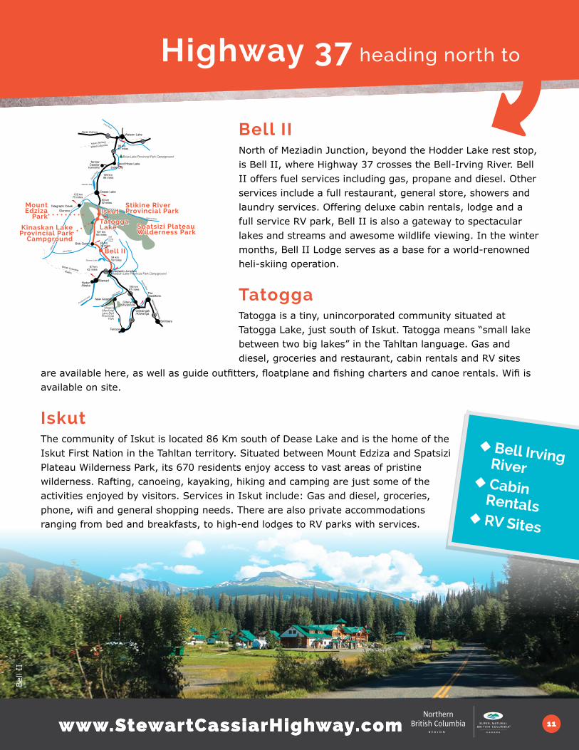
Bell IINorth of Meziadin Junction, beyond the Hodder Lake rest stop, is Bell II, where Highway 37 crosses the Bell-Irving River. Bell II offers fuel services including gas, propane and diesel. Other services include a full restaurant, general store, showers and laundry services. Offering deluxe cabin rentals, lodge and a full service RV park, Bell II is also a gateway to spectacular lakes and streams and awesome wildlife viewing. In the winter months, Bell II Lodge serves as a base for a world-renowned heli-skiing operation.
Tatogga Tatogga is a tiny, unincorporated community situated at Tatogga Lake, just south of Iskut. Tatogga means “small lake between two big lakes” in the Tahltan language. Gas and diesel, groceries and restaurant, cabin rentals and RV sites
are available here, as well as guide outfitters, floatplane and fishing charters and canoe rentals. Wifi is available on site.
IskutThe community of Iskut is located 86 Km south of Dease Lake and is the home of the Iskut First Nation in the Tahltan territory. Situated between Mount Edziza and Spatsizi Plateau Wilderness Park, its 670 residents enjoy access to vast areas of pristine wilderness. Rafting, canoeing, kayaking, hiking and camping are just some of the activities enjoyed by visitors. Services in Iskut include: Gas and diesel, groceries, phone, wifi and general shopping needs. There are also private accommodations ranging from bed and breakfasts, to high-end lodges to RV parks with services.
◆ Bell Irving River◆ Cabin
Rentals◆ RV Sites
16
9797
16
37
37
37A
Liard River
Watson Lake
Good Hope LakeJade City
Telegraph CreekGlenora Iskut
Dease Lake
Tatogga Lake
Bob Quinn
Meziadin Junction
The Hazeltons
Smithers
Terrace
Gitwangak/Kitwanga
Stewart
New Aiyansh
Hyder, Alaska
Meziadin Lake Provincial Park Campground
Nisga’a Memorial Lava Bed Provincial
Park
Bell II
former Cassiar
townsite
Yukon Territory
British Columbia 98 km61 miles
138 km86 miles
83 km52 miles
48 km30 miles
94 km59 miles
156 km97 miles
67 km42 miles
120 km75 miles
Boya Lake Provincial Park Campground
Mount Edziza
Park
Spatsizi Plateau Wilderness Park
Kinaskan Lake Provincial Park
Campground
Dease
Rive
r
Dease Lake
Bowser Lake
Stiki
ne R
iver
Iskut River
Portland Canal Nass River
Skeena River
Yellowhead Highway
Bell Irving River
Stikine River
Alaska Highway
British ColumbiaAlaska
Gitanyow/Kitwancool
Stikine River Provincial Park
107 km66 miles
Bel
l II

www.StewartCassiarHighway.com12
Isku
t
Edzi
zaSpa
tziz
i
Isku
t
Isku
t

www.StewartCassiarHighway.com 13
Iskut Lakes & Iskut River Valley
The Iskut Lakes region is truly one of North America’s last wild frontiers. The Iskut/Tatogga area is a scenic corridor and the gateway to the Stikine area, Spatsizi Plateau Wilderness Park, Mount Edziza Park, the Grand Canyon of the Stikine, and the Upper Stikine River. The area is the traditional home of the Tahltan First Nation. The Tahltan make up over half the population of Iskut, Dease Lake and Telegraph Creek.
This area is known for the Barrage Burn of 1958, when fire destroyed 78,000 hectares. Now, this area is the largest huckleberry patch in British Columbia. The Iskut Lakes area is also home to the world’s largest population of Stone Sheep and one of the largest populations of moose in North America.
The Iskut Lakes area, a chain of over 50 km of lakes along Highway 37, boasts multiple Provincial parks with rafting, canoeing, kayaking, hiking, fishing, hunting and camping for visitors. Many of the parks in the area are day use and tent camping only with the exception of Kinaskan Lake Provincial Park, which has 50 RV sites. Some of these parks include:
Todagin South Slope Provincial ParkThe world’s largest population of nursing Stone Sheep. The park protects habitat for a wide variety of wildlife, including mountain goats, grizzly bears, moose and caribou. Recreation opportunities include wildlife viewing and bow hunting in a backcountry wilderness.
Mount Edziza Provincial ParkThe youngest volcanic cone in North America encompasses over 230,000 hectares of the Tahltan Highlands in northwestern British Columbia. This remote park showcases a spectacular volcanic landscape that includes lava flows, basalt plateaus, cinder fields and cinder cones. In the years since Mount Edziza became dormant, numerous small eruptions have taken place around it, creating more than 30 cinder cones. Perfectly symmetrical, Eve Cone rises 150 meters above the plateau. Mount Edziza, the park’s most outstanding feature, reaches 2,787 meters (9,144 ft).
Spatzizi Plateau Wilderness Provincial ParkSpatsizi Wilderness Park: Spatsizi is a Tahltan word for “Land of the Red Goat”. This extraordinary wilderness park was named after its mountain goats that roll in the park’s iron oxide soil and colour their white coats red. This is one of Canada’s largest and most significant parks, with a true wilderness atmosphere, outstanding scenery and varied terrain; Excellent for quality hiking, photography, and nature study. Lands within the park have an excellent capability for supporting large populations of wildlife.
◆ Parks◆ Sheep◆ Volcano
{side trips}

Kin
aski
n La
ke
Stik
ine
Isku
t
Grizz
lyKin
aski
n La
ke

www.StewartCassiarHighway.com 15www.StewartCassiarHighway.com
Stikine River & Stikine River Provincial ParkThe Stikine River, originating in the Spatsizi Plateau Wilderness Provincial Park, connects that park with the Stikine River Provincial Park and Mt. Edziza Provincial Park
For thousands of years before European contact, the Stikine River was a vital transportation route, and in the late 1800s was a principal route to the Yukon’s Klondike goldfields. The river offers many opportunities for outdoor enthusiasts to “experience the wild”. Experienced canoeists, kayakers or rafters can run sections of the Stikine River through the Coast Mountains to the Pacific Ocean at Wrangell, Alaska. John Muir, in Travels to Alaska, described the river as “a Yosemite that was a hundred miles long”.
Stikine River Provincial Park is a geological feature unparalleled in Canada. Eighty kilometers of steep-walled canyon, composed of sedimentary and volcanic rock, has been carved through eons of river erosion. In the bottom of this sometimes 300 meter deep chasm flows the wild and unnavigable Stikine River, which varies in width from 200 meters to as little as 2 meters at a point near the Tanzilla and Stikine confluence.
Kinaskan Lake Provincial ParkOvernight campers and avid fishers will find Kinaskan Lake to be the perfect spot to stop and relax. The campsites provide a spectacular introduction to northern scenery. From the lakefront campground, visitors are afforded sweeping views up the length of the lake with Todagin Mountains to the east and the Klastline Plateau to the west.
Located at the south end of Kinaskan Lake between the Skeena and Coast Mountain Ranges, this park offers spectacular scenery and good rainbow trout fishing. The Iskut River runs through the park to the south, where it enters a smaller lake called Natadesleen. The Little Iskut River branches off to the west into Mt. Edziza Provincial Park and Recreation Area.
Iskut River Valley (Mountain Goat Viewing)The Iskut River Valley is characterized by a collection of headwater lakes, adjacent plateaus, and is sharply divided by spectacular falls and unnavigable canyons. Traditional trails and excellent wildlife viewing opportunities, including Stone Sheep and mountain goat are possible when accompanied by a knowledgeable guide.
◆ Stikine◆ Mountain Goats◆ Camping
Isku
t

Dea
se L
ake
Dea
se L
ake
Mor
chue
a La
ke
www.StewartCassiarHighway.com 17
Highway 37 heading north to
◆ Gnat Pass◆ Arctic Pacific Divide
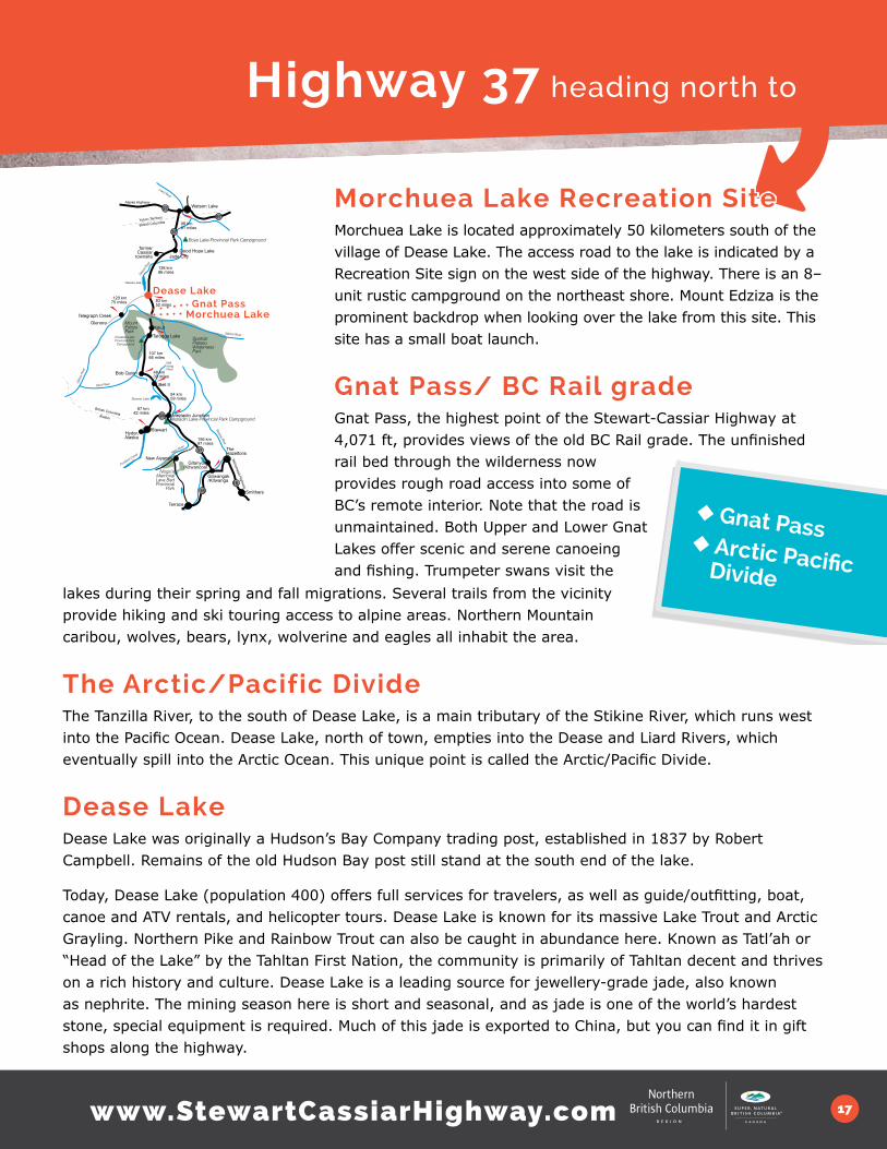
Morchuea Lake Recreation SiteMorchuea Lake is located approximately 50 kilometers south of the village of Dease Lake. The access road to the lake is indicated by a Recreation Site sign on the west side of the highway. There is an 8–unit rustic campground on the northeast shore. Mount Edziza is the prominent backdrop when looking over the lake from this site. This site has a small boat launch.
Gnat Pass/ BC Rail gradeGnat Pass, the highest point of the Stewart-Cassiar Highway at 4,071 ft, provides views of the old BC Rail grade. The unfinished rail bed through the wilderness now provides rough road access into some of BC’s remote interior. Note that the road is unmaintained. Both Upper and Lower Gnat Lakes offer scenic and serene canoeing and fishing. Trumpeter swans visit the
lakes during their spring and fall migrations. Several trails from the vicinity provide hiking and ski touring access to alpine areas. Northern Mountain caribou, wolves, bears, lynx, wolverine and eagles all inhabit the area.
The Arctic/Pacific DivideThe Tanzilla River, to the south of Dease Lake, is a main tributary of the Stikine River, which runs west into the Pacific Ocean. Dease Lake, north of town, empties into the Dease and Liard Rivers, which eventually spill into the Arctic Ocean. This unique point is called the Arctic/Pacific Divide.
Dease Lake Dease Lake was originally a Hudson’s Bay Company trading post, established in 1837 by Robert Campbell. Remains of the old Hudson Bay post still stand at the south end of the lake.
Today, Dease Lake (population 400) offers full services for travelers, as well as guide/outfitting, boat, canoe and ATV rentals, and helicopter tours. Dease Lake is known for its massive Lake Trout and Arctic Grayling. Northern Pike and Rainbow Trout can also be caught in abundance here. Known as Tatl’ah or “Head of the Lake” by the Tahltan First Nation, the community is primarily of Tahltan decent and thrives on a rich history and culture. Dease Lake is a leading source for jewellery-grade jade, also known as nephrite. The mining season here is short and seasonal, and as jade is one of the world’s hardest stone, special equipment is required. Much of this jade is exported to China, but you can find it in gift shops along the highway.
16
9797
16
37
37
37A
Liard River
Watson Lake
Good Hope LakeJade City
Telegraph CreekGlenora
Iskut
Dease Lake
Tatogga Lake
Bob Quinn
Meziadin Junction
The Hazeltons
Smithers
Terrace
Gitwangak/Kitwanga
Stewart
New Aiyansh
Hyder, Alaska
Meziadin Lake Provincial Park Campground
Nisga’a Memorial Lava Bed Provincial
Park
Bell II
former Cassiar
townsite
Yukon Territory
British Columbia 98 km61 miles
138 km86 miles
83 km52 miles
48 km30 miles
94 km59 miles
156 km97 miles
67 km42 miles
120 km75 miles
Boya Lake Provincial Park Campground
Mount Edziza Park
Spatsizi Plateau Wilderness Park
Kinaskan Lake Provincial Park
Campground
Dease
Rive
r
Dease Lake
Bowser Lake
Stiki
ne R
iver
Iskut River
Portland Canal Nass River
Skeena River
Yellowhead Highway
Bell Irving River
Stikine River
Alaska Highway
British ColumbiaAlaska
Gitanyow/Kitwancool
107 km66 miles
Morchuea Lake Gnat Pass

www.StewartCassiarHighway.com18
Drivi
ng t
o Te
legr
aph
Cre
ek
Drivi
ng t
o Te
legr
aph
Cre
ek
Drivi
ng t
o Te
legr
aph
Cre
ek
Stik
ine
Riv
er
Tele
grap
h Cre
ek

www.StewartCassiarHighway.com 19
For an adventurous journey back in time, take the 112-kilometer (70 mile) gravel road from Dease Lake to Telegraph Creek along the Grand Canyon of the Stikine. Following a First Nations’ trading route and the path of early gold prospectors, the road winds along the Stikine Canyon, with dramatic views of the sheer walls cut by the river through layers of volcanic lava. Mountain goats can be spotted among the ledges and rock outcrops of the canyon. The breathtaking road descends to the community of Telegraph Creek, which was once the limit of navigation for riverboats bringing passengers and goods inland.
The Tahltan First Nation has lived in this area for generations, and still harvest the Stikine’s prolific salmon run. Scenic floatplane flights are available, as well as a heart-stopping helicopter tour into the Grand Canyon of the Stikine.
All visitors are asked to respect traditional Tahltan sites. Permission to fish in Tahltan waters can be acquired from the Band Office.
◆ Grand Canyon
◆ Tahltan
Dease Lake to Telegraph Creek
Grand Canyon of the StikineThe Stikine Grand Canyon has prevented all but the most skillful kayakers from paddling the entire length of the river. More people have walked on the moon than have paddled through the Grand Canyon.
{side trip}
16
9797
16
37
37
37A
Liard River
Watson Lake
Good Hope LakeJade City
Telegraph Creek
Glenora Iskut
Dease Lake
Tatogga Lake
Bob Quinn
Meziadin Junction
The Hazeltons
Smithers
Terrace
Gitwangak/Kitwanga
Stewart
New Aiyansh
Hyder, Alaska
Meziadin Lake Provincial Park Campground
Nisga’a Memorial Lava Bed Provincial
Park
Bell II
former Cassiar
townsite
Yukon Territory
British Columbia 98 km61 miles
138 km86 miles
83 km52 miles
48 km30 miles
94 km59 miles
156 km97 miles
67 km42 miles
120 km75 miles
Boya Lake Provincial Park Campground
Mount Edziza Park
Spatsizi Plateau Wilderness Park
Kinaskan Lake Provincial Park
Campground
Dease
Rive
r
Dease Lake
Bowser Lake
Stiki
ne R
iver
Iskut River
Portland Canal Nass River
Skeena River
Yellowhead Highway
Bell Irving River
Stikine River
Alaska Highway
British ColumbiaAlaska
Gitanyow/Kitwancool
107 km66 miles
Drivi
ng t
o Te
legr
aph
Cre
ek

www.StewartCassiarHighway.com20
Tele
grap
h Cre
ek
Tele
grap
h Cre
ekTe
legr
aph
Cre
ek
Tele
grap
h Cre
ekTe
legr
aph
Cre
ek
Padd
ling
Sou
th fro
m T
eleg
raph
Gra
nd C
anyo
n of
the
Stik
ine

www.StewartCassiarHighway.com 21
Points of interest from Dease Lake to Telegraph Creek
Tahltan 92 KM FROM DEASE LAKE: Tahltan is a First Nations historic fishing site at the confluence of the Stikine and Tahltan Rivers. On the canyon wall across the river is Home of the Crow- or Sesk’iye cho kime (pronounced Sis Kia Cho Kima). Naturally occurring in the basalt rock face of the canyon is the shape of the massive outstretched wings and head of a bird. In Tahltan culture, the crow is the Trickster, the creator of light, who helped bring humans into the world. Some describe this location as the birthplace of the Tahltan.
Waterfall Viewpoint Trail 101KM FROM DEASE LAKE: A pullout at the road’s side leads to this short and very steep trail, but the view of the waterfall freefalling from the canyon’s edge is worth the stop. Use caution!
Telegraph Creek112 KM FROM DEASE LAKE: A community of roughly 250 permanent residents, Telegraph Creek has very basic services so ensure you have all supplies in case services are closed. Built on terraces overlooking the Stikine River, Telegraph Creek is rich with history. First a Tahltan settlement, it became an important transportation and communication centre during the exciting times of the gold rushes of the 1860s and 1870s, and a trailhead for Yukon gold seekers of the 1890s. Prospectors once enlivened this quiet riverside community, which provides glimpses of a bygone era with a former Hudson Bay Trading Post and other turn of the century buildings.
Telegraph Creek’s name hails from the 1860s, when the Collins Overland Telegraph was racing to complete the first telegraph line between North America and Europe, across the Bering Strait. Beat out in August 1866 by a trans-Atlantic connection, Collins abandoned the line, but not before it had crossed the Stikine River at -Telegraph Creek. Built later, the Yukon Telegraph followed a similar route and linked Dawson City to southern Canada. Remains of the telegraph line and its network of service cabins can still be found.
Sawmill Lake 114KM FROM DEASE LAKE: Sawmill Lake has great trout fishing, a picnic site and serves as a landing location for float planes.
Glenora 131 KM FROM DEASE LAKE: Upstream from Telegraph Creek, Glenora was the original Hudson Bay Fort location. Because Telegraph Creek was head of navigation for sternwheelers carrying prospectors up the Stikine en route to the Klondike, it was a better location. The fort was actually dismantled and moved to its current location in Telegraph Creek.
◆ Waterfall◆ Fishing◆ Telegraph Creek
www.StewartCassiarHighway.com22
Jade
City
Jade
City
Jade
City
Jade
City
Boy
a La
ke
Boy
a La
kePi
ke

www.StewartCassiarHighway.com 23
Highway 37 heading north to
Sawmill Point Recreation SiteSawmill Point Recreation Site, 41 km north of the community of Dease Lake, gives direct access to the lake. Once the site of a short-lived Hudson’s Bay Company post established in 1838 and abandoned in 1839, now it is a popular camping and fishing spot. Try your hand at catching the good-sized lake trout here, and look for the remains of the foundation of the old fort. Dease Lake has historically been an important First Nations’ transportation corridor.
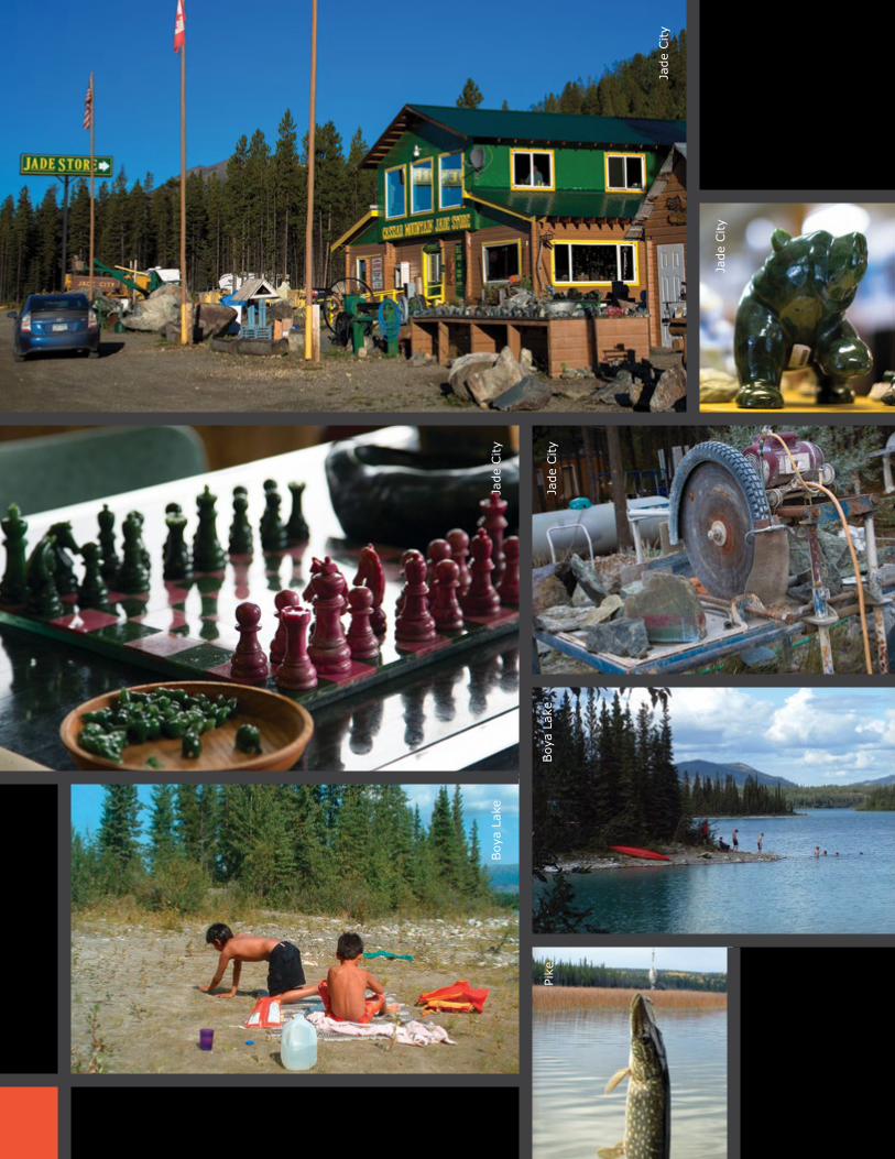
Jade City/CassiarJade City, named for the extensive jade deposits found nearby, offers a glimpse into mining this lovely stone. With a population of approximately 20 people, the family-run jade mining operation is a stop of particular interest on the Stewart Cassiar Highway. With 40 years of history mining in the area, the owners of the Cassiar Mountain Jade
Store are experts in everything from prospecting to carving it. In Jade City you will find FREE overnight RV parking, accommodation, a restaurant, native art shop, jade gallery and mining exhibits.
A 10-km drive west off the highway leads to the ghost town of Cassiar. An asbestos mining town, the mine operations ended in 1992. Flowers now bloom where houses stood and an abandoned tramline still stands idle. Abandoned cabins and equipment let you imagine the life of early miners and settlers. Old mining trails into the mountains can be travelled on foot or with 4x4 vehicles or ATVs, with chances to see Thinhorn mountain sheep, mountain goat, caribou and moose. NOTE: There are no public facilities in the old Cassiar town-site, and it is closed to visitors.
boya lake
cassiar
16
9797
16
37
37
37A
Liard River
Watson Lake
Good Hope Lake
Jade City
Telegraph CreekGlenora
Iskut
Dease Lake
Tatogga Lake
Bob Quinn
Meziadin Junction
The Hazeltons
Smithers
Terrace
Gitwangak/Kitwanga
Stewart
New Aiyansh
Hyder, Alaska
Meziadin Lake Provincial Park Campground
Nisga’a Memorial Lava Bed Provincial
Park
Bell II
former Cassiar
townsite
Yukon Territory
British Columbia 98 km61 miles
138 km86 miles
83 km52 miles
48 km30 miles
94 km59 miles
156 km97 miles
67 km42 miles
120 km75 miles
Boya Lake Provincial Park Campground
Mount Edziza Park
Spatsizi Plateau Wilderness Park
Kinaskan Lake Provincial Park
Campground
Dease Lake
Bowser Lake
Stiki
ne R
iver
Iskut River
Portland Canal Nass River
Skeena River
Yellowhead Highway
Bell Irving River
Stikine River
Alaska Highway
British ColumbiaAlaska
Gitanyow/Kitwancool
107 km66 miles
sawmill pointDease River
Boya Lake Provincial ParkWith many islands and lovely bays, Boya Lake Provincial Park is an excellent place for canoeing or kayaking. Look into its depths to see fish swimming below, visible against the white marl bottom. Its unique aqua-green hue and relatively warm and swimmable water makes Boya Lake a must-visit place on the route. There are 44 campsites with ample parking. Canoe and kayak rentals are available from the park operator. Two interpretive trails lead from the campground around the shores of the lake, where you will find a wide variety of wildflowers, and the chance to see beavers, moose, and caribou. Boya Lake lies within the traditional territory of the Kaska Dene First Nation who still hunt and trap in the area.
North to the YukonNorthbound from Boya Lake lies the Yukon Territory with the British Columbia/ Yukon border 81km (50 miles) north of the park. The Alaska Highway junction is 86km (53 miles), Watson Lake 109km (68 miles) and Whitehorse is 509km (367 miles) from Boya Lake. All services and amenities are available in Watson Lake. For more information pick up the new Watson Lake/ Yukon guide or visit www.yukoninfo.com
◆ Jewelry◆ Cassiar◆ Yukon

www.StewartCassiarHighway.com
The Stewart Cassiar Visitor Guide is a joint publication of Northern BC Tourism and the Regional District of Kitimat Stikine, with contributions from:
Destination BCStewart Cassiar Tourism CouncilBC Parks
Photos: Simon Ratcliffe, Rob Seaton, Tim Swanky, JF Bergeron, Sue Chief Gary Fiegehen Photography, Sandra Smith, Paul Glover
Design: Sandra Smith at Spark Design
These maps are not to scale and are meant as a visual illustration only.
This document is available electronically at www.stewartcassiarhighway.com
©2014 Northern BC Tourism and, Regional District of Kitimat Stikine
PRINTED IN CANADA
A Northern BC Tourism Association initiative.
There’s a new app in town.
Introducing the new ‘Northern BC’ Travel App available free at the
App Store for iPhone or iPad and at Google Play for Android.
The road
trip of a
lifetime!
landscape • history culture • wildl ife