discover-aq outlook for sunday, july 3, 2011 · pdf file7/2/2011 · discover-aq...
TRANSCRIPT

DISCOVER-AQ Outlook for Sunday, July 3, 2011
Despite a forecast high-temperature day tomorrow in the Baltimore-Washington area, considerable cloud cover will prevent ozone from reaching the high values seen today. Code Yellow ozone is forecast for tomorrow in the Baltimore area and borderline Code Yellow/Orange in the DC area. The GEOS-5 aerosol forecast brings considerable smoke aerosol into the region on Sunday with AOT possibly reaching values over 1.0. However, cloud cover may prevent us from seeing much of this aerosol plume. The NAM model produces broken to overcast high clouds in the morning and the possibility of thunderstorms in the afternoon. These clouds and possible storms are associated with a frontal system approaching from the west. Therefore, we have decided not to fly on Sunday. The front will stall just to the southeast of the DC area, and will lead to continued high cloudiness on Monday. Therefore, tomorrow we will need to revisit the forecast for Monday, July 4.

Clare FlynnJuly 2, 2011
Recommendations for July 3rd-July 6th:
Sun., July 3: No Fly, Hot but Considerable Cloudiness
Mon., July 4: Perhaps No Fly (clouds) – to be updated tomorrow
Tues., July 5: Perhaps Fly, Cooler, less clouds
Wed., July 6: Perhaps Fly -- clouds increasing

Code Orange Ozone Alert Today
– 1 hr Ozone at 9 AM: 80 ppbv Edgewood79 Beltsville75 Padonia
- 8-hr Ozone: Code Orange reached at Essex, Edgewood and Beltsville by 2 PM; Code Red at Edgewood at 3 PM.

Current Conditions• Broken clouds above 20,000 ft
• Temp – mid 80s, Dew – mid 50s
• SLP – 1018 mb and falling slowly
• Convection in OH
• Thin line of opaque Ci pushing to SE
• Fires in NC

Sunday: Hot. Chance of showers. Cold front brings clouds and scattered convection.

Monday: Hot but lower humidity. Cold front stalls south of region.

Sunday ->
Monday ->

Tuesday ->
Wednesday->

Thursday ->

Bufkit – NAM (12 UTC 02 July)
-Clouds and precip Sunday afternoon
-Low clouds linger into early AM Monday
-BL on Monday just under 5,000 ft
-High clouds on Monday afternoon reaching below 25,000 ft at 1900 EDT
-Clear on Tuesday with BL ~ 6,000 ft
Clouds
Precip
SundayMonday
BL Height
Tuesday

Sunday 2pm: Presence of high clouds (above 18,000ft) throughout day

Monday 8am: High clouds present through at least morning (NCAR NAM); NWS predicts clouds by 2pm

NAM – MSLP and Clouds Monday Evening
• Front associated with Low in Canada moves out to the east
• Lingering high-level clouds throughout the day
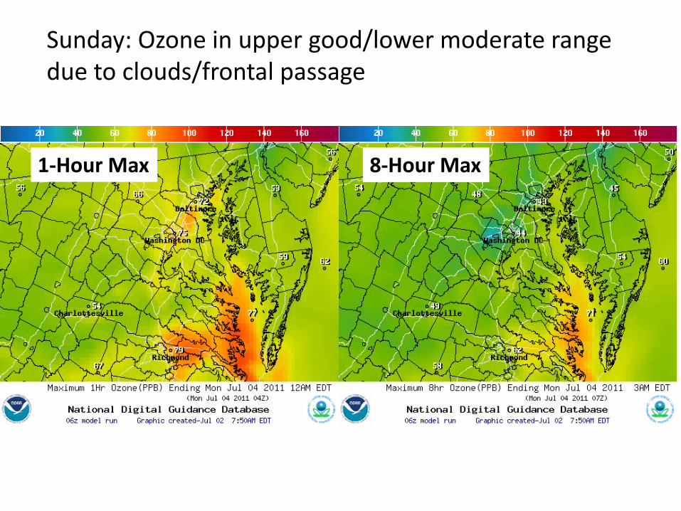
Sunday: Ozone in upper good/lower moderate range due to clouds/frontal passage
1-Hour Max 8-Hour Max

Sunday (4pm): Ozone air quality much better than Saturday, concentrations ~ 30-50ppbv lower
1-Hour 8-Hour
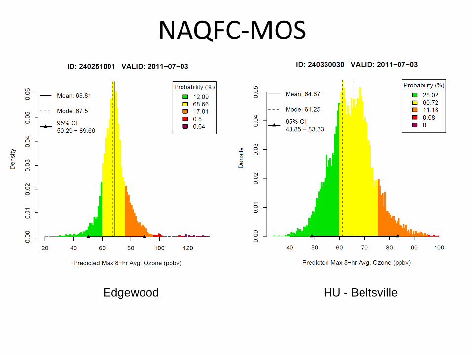
NAQFC-MOS
Edgewood HU - Beltsville

Today’s AOT forecast, no major impact of wildfires

Smoke moves through region through Sun. afternoon/evening

By Sunday a pronounced impact may be seen over regionSome impact through Monday morning, then moves off coast

GEOS-5 Aerogram through 06 July
Smoke influence on Sunday through early Monday
Persistent clouds at mid and upper levels on Sunday
Precip. on Sunday
High clouds on Monday
Aerosol Extinction peaking in afternoon at surface.
Aerosol Extinction peak at ~ 18,000 ft