disaster management projects using wireless sensor networks… · · 2017-01-09disaster...
TRANSCRIPT

Disaster Management Projects using Wireless Sensor
Networks: An Overview
Imane Benkhelifa
CERIST Research Center
Algiers, Algeria
Nadia Nouali-Taboudjemat
CERIST Research Center
Algiers, Algeria
Samira Moussaoui
USTHB- Department of Informatics
Algiers, Algeria
Abstract— There are numerous projects dealing with disaster
management and emergency response that use wireless sensor
networks technologies. Indeed, WSNs offer a good alternative
compared to traditional ad hoc networks. Air pollution
monitoring, forest fire detection, landslide detection, natural
disaster prevention, industrial sense and control applications,
dangerous gas leakage, water level monitoring, vibration
detection to prevent an earthquake, radiation monitoring are
examples of the WSN applications related to disaster
management. This paper presents an overview of the recent
projects using WSN to collect data in disaster areas.
Keywords—Wireless Sensor Networks; Disaster Management;
Emergency Response; Information Systems.
I. INTRODUCTION
Collecting and sharing disaster information about damaged
area is the most important activity to support decision-
making in rescue processes.
Disaster Management Systems that use Wireless Sensor
Networks (WSNs) have received much attention by
researchers in the last five years. This interest comes from
the increasing number of disasters all around the world,
causing the loss of a huge number of lives and properties and
on the easy use of these new and cheap technologies. Indeed,
WSNs offer an interesting alternative to wired networks
when infrastructures collapse, for instance, after an
earthquake or a tsunami. In addition, WSN have attractive
characteristics, they are known to be auto-configurable, auto-
organizing, have small volumes, etc.
Different environment parameters can be detected by
sensors, such as, the atmosphere humidity and temperature
useful for detecting forest and building fires, toxic gases
caused by an explosion, water level to detect and prevent
floods, vibration level to detect chocks and earthquakes and
many other data. Sensors can offer additional useful services.
For instance, an estimation of the victim number by
calculating the number of persons holding Bluetooth devices,
a rapid localization of incidents and victims, a fast and
wireless communication between sensors, first responders
and command centers. Furthermore, multimedia sensors can
take useful photos and videos of the affected area and
transfer them in real-time to help first responders and
decision makers getting a global idea about the current
situation.
In the following section, we give general descriptions of
some disaster management projects that use wireless sensor
networks. Some were proposed to manage specific disasters
such as earthquakes, landslides, air pollution and healthcare
while others can be applied in many scenarios.
II. DISASTER MANAGEMENT PROJECTS
A. SENDROM
SENDROM (SEnsor Network for Disaster Relief
Operations Management) was mainly proposed to be used in
the case of earthquakes in Turkey as it is one of the most
subject countries to earthquakes [1].
The architecture of SENDROM consists of sensor nodes
deployed prior to a disaster and central nodes stored nearby
strategic centers and linked to the SENDROM database.
The nodes are divided into several types; Cnodes are data
Collector Nodes such as mobile computers. Snodes, deployed
prior to a disaster, sense and report any living human in the
vicinity. They are divided into Standalone nodes which are
located, for instance, inside drawers and cabinets and
Embedded nodes located, for example, in washing machines.
This kind of nodes is capable of detecting vibration during an
earthquake. Inodes are used for individuals and human
beings. They are also divided into Standalone nodes which
can be placed, for example, in pockets or in individual bags
and Embedded ones in wristwatches, for instance. Cnodes
invoke the Snodes and Inodes and then send the received
data to the Central SENDROM Database. This latter is
continuously updated by the EOCs (Emergency Operation
Center) and Cnodes. Figure 1 (Cayirci et al. 2007) shows the
SENDROM architecture after a disaster.

Figure 1: SENDROM after a disaster (Cayirci et al. 2007).
SENDROM Database Server (SDS) has the role of getting
information about buildings and individuals. This server can
be queried form Internet allowing rescue teams to get prior
information while on the way to the site. Rescue teams and
EOCs query the SDS via Cnodes. Snodes and Inodes send
data to the SDS via mobile access points (UAVs, cars, etc.).
Note that Inodes always generate reports while Snodes
generate them only when they detect a living human being in
their vicinity. Sensor nodes include in the report the task id.
of the query and Cnodes use the directional antennae to
broadcast the task depending on their regions.
B. INSYEME
The main aim of the IN.Sy.EME (Integrated System for
Emergency) project is to define an integrated system to
support emergency operations that integrate a pervasive Grid
structure and a wireless communication network [2]. The
network is composed of a variety of fixed and mobile
processing nodes. The main characteristics of this network
are the high heterogeneity, the mobility, and the dynamism of
its nodes. In particular, Wireless Sensor Networks are needed
to collect data from the environment in order to support
forecasting methods to monitor and predict the disaster
evolution. The vehicle grid then becomes a sink of the
network which can be remotely accessed from the Internet.
Authors of INSYEME propose also to equip the sensing
devices with interfaces to wireless access networks such as
2/3G, WLAN and WMAN enabling ubiquitous connectivity.
Figure 2: The forecasting model in INSYEME (Fantacci et al. 2010).
In addition, they propose to use WIMAX which can serve as
a backbone for integrating WSNs and connecting
heterogeneous networks. However, the WIMAX has to be
optimized in order to provide an excellent Non Line of Sight
(NLoS) coverage.
Figure 3: A heterogeneous WIFI-WIMAX network (Fantacci et al. 2010).
For routing purposes, authors propose to use an
interconnection technique between an IEEE 802.11x network
and a WIMAX network while maintaining the same QoS
level between the two networks.
C. Telemedicine with WSNs
This project was proposed to relay gathered information
from the disaster scene with a telemedicine system [3].
The proposed architecture supports multi hopping
mechanism to transfer the information among multiple cells
using Ad hoc relay stations that collect data from sensor
nodes. Some of the nodes are also used as base stations in
order to route the data from one location to another in critical
emergency conditions. The base station is GSM based if a
cellular network is available otherwise a WiMax based
antennae is used. The purpose of using multi-channel cluster-
based architecture is to provide energy efficient routing
protocol among multiple sinks; each sink is responsible for
maintaining a cluster tree and sending signal to the
neighborhood.
The proposed network architecture is composed of three
entities; Wireless Sensor Network, emergency response data
center and satellite communication infrastructure.
Wireless Sensor Network: the network is divided
into four adjacent cells where each cell is composed of four
ad hoc relay stations covering each cluster. Each cluster is
directly interfaced with a sink node, responsible for
maintaining communication path to the base station.
Emergency Response Database: the role of this unit
is to receive and store information about critical disaster
conditions.
Satellite Communication Interface: Information
related to the disaster is transferred via this communication
media towards some medical services such as mobile
ambulances and hospitals using telemedicine based
infrastructure.
Figure 4: WSNs with Telemedicine (Ahmad et al. 2011).
Authors affirmed that their networked architecture allows
reducing energy consumption; however, no performance
analysis was conducted.
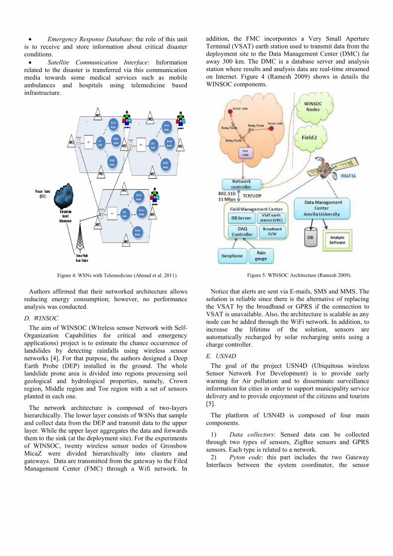
D. WINSOC
The aim of WINSOC (WIreless sensor Network with Self-
Organization Capabilities for critical and emergency
applications) project is to estimate the chance occurrence of
landslides by detecting rainfalls using wireless sensor
networks [4]. For that purpose, the authors designed a Deep
Earth Probe (DEP) installed in the ground. The whole
landslide prone area is divided into regions processing soil
geological and hydrological properties, namely, Crown
region, Middle region and Toe region with a set of sensors
planted in each one.
The network architecture is composed of two-layers
hierarchically. The lower layer consists of WSNs that sample
and collect data from the DEP and transmit data to the upper
layer. While the upper layer aggregates the data and forwards
them to the sink (at the deployment site). For the experiments
of WINSOC, twenty wireless sensor nodes of Grossbow
MicaZ were divided hierarchically into clusters and
gateways. Data are transmitted from the gateway to the Filed
Management Center (FMC) through a Wifi network. In
addition, the FMC incorporates a Very Small Aperture
Terminal (VSAT) earth station used to transmit data from the
deployment site to the Data Management Center (DMC) far
away 300 km. The DMC is a database server and analysis
station where results and analysis data are real-time streamed
on Internet. Figure 4 (Ramesh 2009) shows in details the
WINSOC components.
Figure 5: WINSOC Architecture (Ramesh 2009).
Notice that alerts are sent via E-mails, SMS and MMS. The
solution is reliable since there is the alternative of replacing
the VSAT by the broadband or GPRS if the connection to
VSAT is unavailable. Also, the architecture is scalable as any
node can be added through the WiFi network. In addition, to
increase the lifetime of the solution, sensors are
automatically recharged by solar recharging units using a
charge controller.
E. USN4D
The goal of the project USN4D (Ubiquitous wireless
Sensor Network For Development) is to provide early
warning for Air pollution and to disseminate surveillance
information for cities in order to support municipality service
delivery and to provide enjoyment of the citizens and tourists
[5].
The platform of USN4D is composed of four main
components.
1) Data collectors: Sensed data can be collected
through two types of sensors, ZigBee sensors and GPRS
sensors. Each type is related to a network.
2) Pyton code: this part includes the two Gateway
Interfaces between the system coordinator, the sensor

networks and the Database Interface linking the system
coordinator to a MySQL database (See figure 6).
3) Database: an actual relational database (MySQL)
was used.
4) End User Interface: the user can query the database
and extract analyzed and localized data. Results can be
shown via GoogleMaps services.
Figure 6: USN4D Platform (Bagula et al. 2012).
USN4D uses XBee Waspmotes [8] which work with both
GPRS (enabling sending and receiving SMS) and ZigBee as
dissemination protocols. In addition, Data are stored in SD
cards available on the mote. The used Gas card of a
Waspmote can support 11 different gas sensors (CO, CO2,
C6H5CH3, etc) but only six can be piggybacked at once, in
addition to temperature, humidity and atmospheric pressure
sensors. Some experiments were successfully tested namely:
(a) Monitoring a room’s temperature every five minutes and
sending SMS alerts if it is greater than 20°c. (b) During
transportation of containers, sending SMS with GPS
coordinates if a container is stolen. (c) Monitoring motor
behavior by measuring the motor acceleration four times per
second and sending SMS or with other wireless method the
alert to a pc. (d) Measuring air pollution in Cape Town, by
reading data every thirty (30) seconds from Gas sensors,
storing them on SD card with date, time and position, and
sending SMS to a given phone number when pollution
reaches given threshold values.
F. AWARE
AWARE is the acronym of Platform for Autonomous self-
deploying and operation of Wireless sensor-actuator
networks cooperating with AeRial objects [6].
This European project consists in developing a platform
enabling the cooperation of autonomous aerial vehicles
(UAVs) with ground wireless sensor-actuator networks
composed of static and mobile nodes. Additionally, the
project also considers the self-deployment of the network
using autonomous helicopters that have the ability to
transport and deploy loads. The main goal of this project is to
build a middleware enabling the cooperation of
heterogeneous objects including aerial vehicles, static-
actuator nodes and mobile nodes carried by ground vehicles
and agents, so that the whole system can detect events (e.g.
fire) by means of temperature sensors and wirelessly
communicate these events [6][9].
Figure 7: AWARE Architecture (Erman et al. 2008).
The platform consists of two different networks, a High
Bandwidth Network (HBN) and Low Bandwidth Network
(LBN), connected through “gateways”. HBN is composed of
personal computers, Ground Camera Nodes and mobile
robots capable of transmitting data through IEEE 802.3 or
IEEE 802.11 networks. The LBN is composed of WSN
nodes having very limited computing and data transmitting
capabilities. In addition, any device capable of direct
communication with both networks might act as a gateway
(see figure 7 and 8).
The AWARE middleware contains three main components:
Routing Engine, Filtering Engine and Gateway Management
Engine. For routing, researchers used some variants of
flooding gossiping, AODV as well as geographic routing.
The filtering engine is responsible of the data processing and
aggregation and message suppression. Location is one of the
main factors used in the filtering phase.
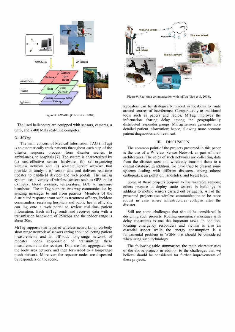
Figure 8: AWARE (Ollero et al. 2007).
The used helicopters are equipped with sensors, cameras, a
GPS, and a 400 MHz real-time computer.
G. MiTag
The main concern of Medical Information TAG (miTag)
is to automatically track patients throughout each step of the
disaster response process, from disaster scenes, to
ambulances, to hospitals [7]. The system is characterized by
(a) cost-effective sensor hardware, (b) self-organizing
wireless network and (c) scalable server software that
provide an analysis of sensor data and delivers real-time
updates to handheld devices and web portals. The miTag
system uses a variety of wireless sensors such as GPS, pulse
oximetry, blood pressure, temperature, ECG to measure
heartbeats. The miTag supports two-way communication by
sending messages to and from patients. Members of the
distributed response team such as treatment officers, incident
commanders, receiving hospitals and public health officials,
can log onto a web portal to review real-time patient
information. Each miTag sends and receives data with a
transmission bandwidth of 250kbps and the indoor range is
about 20m.
MiTag supports two types of wireless networks: an on-body
short range network of sensors caring about collecting patient
measurements and an off-body long-range network of
repeater nodes responsible of transmitting these
measurements to the receiver. Data are first aggregated via
the body area network and then forwarded to a long-range
mesh network. Moreover, the repeater nodes are dispensed
by responders on the scene.
Figure 9: Real-time communication with miTag (Gao et al. 2008).
Repeaters can be strategically placed in locations to route
around sources of interference. Comparatively to traditional
tools such as papers and radios, MiTag improves the
information sharing delay among the geographically
distributed responder groups. MiTag sensors generate more
detailed patient information; hence, allowing more accurate
patient diagnostics and treatment.
III. DISCUSSION
The common point of the projects presented in this paper
is the use of a Wireless Sensor Network as part of their
architectures. The roles of such networks are collecting data
from the disaster area and wirelessly transmit them to a
central database. In addition, we have tried to present some
systems dealing with different disasters, among others:
earthquakes, air pollution, landslides, and forest fires.
Some of these projects propose to use wearable sensors;
others propose to deploy static sensors in buildings in
addition to mobile sensors carried out by agents. All of the
presented projects use wireless communication to be more
robust in case where infrastructures collapse after the
disaster.
Still are some challenges that should be considered in
designing such projects. Routing emergency messages with
delay constraints is one the important tasks. In addition,
locating emergency responders and victims is also an
essential aspect while the energy consumption is a
fundamental problem in WSNs that should be considered
when using such technology.
The following table summarizes the main characteristics
of the above projects in addition to the challenges that we
believe should be considered for further improvements of
these projects.

TABLE I: DISASTER MANAGEMENT PROJECTS
Project Main Scenario Supported Networks Challenges
SENDROM [1] Earthquake Detection WSN Indoor Localization
INSYEME [2] Emergency Operations WSN, WiFi, WiMax Localization and Security
WSN with Tele-
medicine [3]
Evacuating Victims WSN, GSM, WiMax Heterogeneity of networks
WINSOC [4] Landslide Detection WSN, WiFi, Satellite communication,
GPRS
The DEP-sensor deployment
USN4D [5] Air Pollution Detection WSN, GPRS, ZigBee Real-time Routing
AWARE [6][9] Surveying and Filming,
Fire Detection
WSN, Mobile WSN, Multimedia
WSN
The choice among Multitude of routing
protocols
MiTag [7] Tracking patients WSN & RFID, Mesh, WAN Radio Interferences
IV. CONCLUSION
In this paper, we have presented some disaster and
emergency management projects that use wireless
sensor networks in their architectures to measure and
communicate useful data. The role of a sensor node is to
sense the environment, communicate and exchange
sensory data with other nodes in the area, locally
process its own data and make smart decisions about
what it observes. Many national and international
projects that use WSNs have been investigated in order
to facilitate the response management and hence save
lives. To the best of our knowledge, this paper is the
first that surveys the projects dealing with disaster
management and emergency response and that use the
technology of wireless sensor networks. Since these
projects are based on WSNs, they inherit all the
advantages and the limits of such networks, so,
designers must take this point into consideration.
In order to benefit from previous projects and
experiences, we plan soon to design a novel architecture
based on wireless mesh sensor networks that responds
to emergency requirements such as the mobility of first
responders and real-time routing and localization while
taking account of the energy conservation of the sensor
network.
ACKNOWLEDGMENTS
This work is part of the national research project
SAGESSE supported by CERIST Research Center,
Algiers, Algeria and funding from the Algerian General
Direction of Scientific Research and Technological
Development fund under the grant 5/CR0167/177.
REFERENCES
[1] E. Cayirci and T. Coplu. “SENDROM: Sensor Networks for
Disaster Relief Operations Management”. Wireless Networks,
Vol. 13 Issue 3, June 2007. pp. 409-423.
[2] R. Fantacci, D. Marabissi and D. Tarchi; “A novel
communication infrastructure for emergency management: the In.Sy.Eme. vision”. Wirel. Commun. Mob. Comput. 2010. pp.
1673-1681.
[3] N. Ahmad, N. Riaz and M. Hussain.”Ad hoc wireless Sensor
Network Architecture for Disaster Survivor Detection”.
International Journal of Advanced Science and Technology Vol. 34, September, 2011. pp. 9-16.
[4] M. V. Ramesh. “Real-time Wireless Sensor Network for
Landslide Detection”. In Proc. of the Third International Conference on Sensor Technologies and Applications
(SENSORCOMM). 2009. pp. 405-409.
[5] A. Bagula, M. Zennaro, G. Inggs, S. Scott and D. Gascon.” Ubiquitous Sensor Networking for Development (USN4D): An
Application to Pollution Monitoring”. Sensors 2012. Vol. 12. pp. 391- 414.
[6] A. Ollero, M. Bernard, M. La Civita, L. Van Hoesel, P.J.
Marron, J. Lepley and E. De Andres.” AWARE: Platform for Autonomous self-deploying and operation of Wireless sensor-
actuator networks cooperating with unmanned AeRial vehicles”.
In Proc. of the 2007 IEEE International Workshop on Safety, Security and Rescue Robotics. September 2007.pp. 1-6.
[7] T. Gao, C. Pesto, L. Selavo, Y. Chen, J. Ko, J. Lim, A. Terzis, A. Watt, J. Jeng, B. Chen, K. Lorincz, and M. Welsh. “Wireless
Medical Sensor Networks in Emergency Response:
Implementation and Pilot Results”. In Proc. of the IEEE Conference on Technologies for Homeland Security, 2008. pp.
187 - 192
[8] Waspmote Plug & Sense! Technical Guide. Document Version:
v0.2 - 11/2012. ©Libelium Comunicaciones Distribuidas S.L.
2012. pp. 1-136.
[9] A. T. Erman, L. Van Hoesel and P. Havinga. “AWARE:
Platform for Autonomous Self-Deploying and Operation of
Wireless Sensor-Actuator Networks Cooperating with AeRial ObjEcts”. Univesity of Twenty. The Netherlands. 2008. pp.1-2.